Unfortunately, we don't support your browser (Internet Explorer) anymore, some functionalities could not work. Click here to get information on how to upgrade your browser.
Ruufer - bike path
BE - DE - NL

Travelogue
is now used as a trolley station. Good starting point for the journey to the starting point of the first stage.
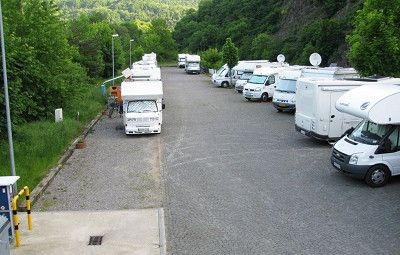
Have big parking lot. NO designated WOMO parking space. We stayed there and it didn't bother anyone.
is now used as a trolley station. Good starting point for the journey to the starting point of the first stage.
Have big parking lot. NO designated WOMO parking space. We stayed there and it didn't bother anyone.
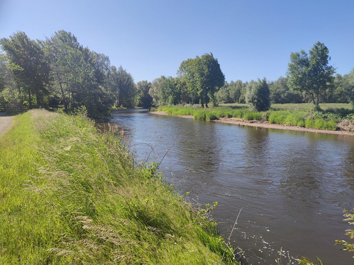
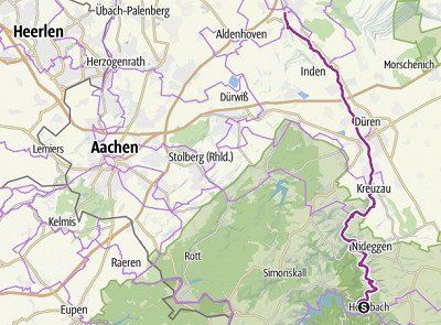
Anyone who goes to Rurquelle in the Belgian Fagnes will not initially believe that this enchanted place is only a few kilometers away from Aachen, Eupen or Liège. Here, at the highest point in Belgium, visitors can expect an unusual habitat and an ecosystem that is unique in Central Europe, a raised bog of an unusual size. The town of Monschau invites every cyclist to take a rest, explore the city center and enjoy the flair of the former stronghold of cloth making. Through the deep notched valley of the Rur we head towards the Rurseenplatte. Towering slate rocks accompany the small road and the subsequent off-road paths that lead through the valley to Einruhr.
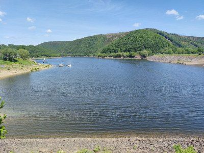
The next section of the RurUfer cycle path focuses on the only national park in NRW, the Eifel National Park, in addition to the large dammed water areas. You will experience the area where wild cats, woodpeckers and wall lizards call the shots and where people "let nature be nature". The RurUfer cycle path runs along both banks of the Rursee. The route to the right of the bank crosses the national park, to the left you will come across the water sports resort of Woffelsbach before you reach your destination, Heimbach.
Distance 65.3 km
Duration 4:30 h
Ascent 303 m
Descent 793 m
Highest point 693 m
Lowest point 204 m
Source: outdooractive.com
Anyone who goes to Rurquelle in the Belgian Fagnes will not initially believe that this enchanted place is only a few kilometers away from Aachen, Eupen or Liège. Here, at the highest point in Belgium, visitors can expect an unusual habitat and an ecosystem that is unique in Central Europe, a raised bog of an unusual size. The town of Monschau invites every cyclist to take a rest, explore the city center and enjoy the flair of the former stronghold of cloth making. Through the deep notched valley of the Rur we head towards the Rurseenplatte. Towering slate rocks accompany the small road and the subsequent off-road paths that lead through the valley to Einruhr.
The next section of the RurUfer cycle path focuses on the only national park in NRW, the Eifel National Park, in addition to the large dammed water areas. You will experience the area where wild cats, woodpeckers and wall lizards call the shots and where people "let nature be nature". The RurUfer cycle path runs along both banks of the Rursee. The route to the right of the bank crosses the national park, to the left you will come across the water sports resort of Woffelsbach before you reach your destination, Heimbach.
Distance 65.3 km
Duration 4:30 h
Ascent 303 m
Descent 793 m
Highest point 693 m
Lowest point 204 m
Source: outdooractive.com
Starting from Kalterherberg train station, we first ride on the old railway line to then reach the starting point of the Signal de Botrange cycle path on the banks of the Rur.
Back the same way and on to Monschau. The plan was that only I would drive back to get the camper and use the parking space in Monschau for the next night.
After seeing the Monschau parking space https://www.promobil.de/stellplatz/stellplatz-am-vennbad-5a143c59f28b876f71468351.html we changed our plans and drove to Ruhrberg.
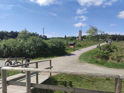
https://www.promobil.de/stellplatz/wohnmobilstellplatz-rurberg-588f1ff7721d54a528161964.html
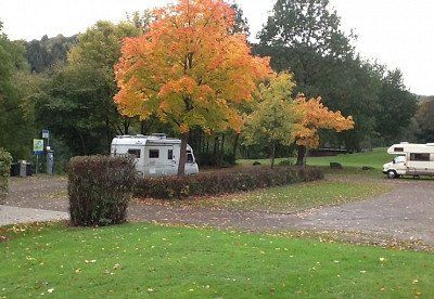
Beautifully situated at the bathing lake. Has everything a decent pitch needs, except a baker. Unfortunately quite expensive.
https://www.promobil.de/stellplatz/wohnmobilstellplatz-rurberg-588f1ff7721d54a528161964.html
Beautifully situated at the bathing lake. Has everything a decent pitch needs, except a baker. Unfortunately quite expensive.
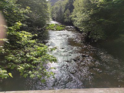
Back to Monschau it goes through a narrow valley that the Rur dug here.
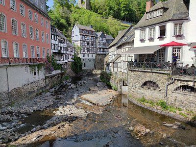
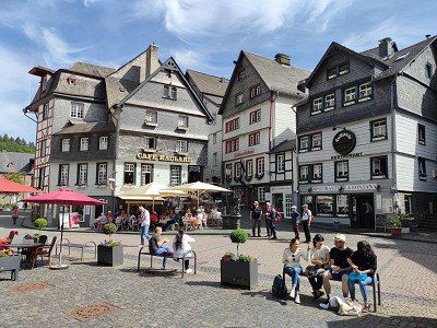
A lot of half-timbering and beautiful old houses give an idea that a lot of money was once made in Monschau. The city is well preserved and now lives from tourism.
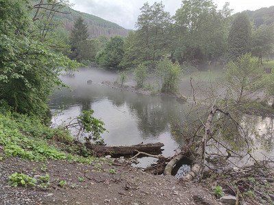
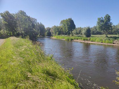
Back at the Rursee we are dealing with a completely different landscape. Of course, man intervened and dammed this lake. With many side arms, which were probably formed by some tributaries, it goes to Heimbach. As a way back to the parking space, we use the other side of the lake as a small shortcut.
Then we transfer to Heimbach.
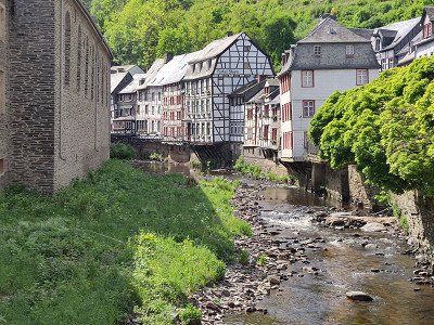
Back to Monschau it goes through a narrow valley that the Rur dug here.
A lot of half-timbering and beautiful old houses give an idea that a lot of money was once made in Monschau. The city is well preserved and now lives from tourism.
Back at the Rursee we are dealing with a completely different landscape. Of course, man intervened and dammed this lake. With many side arms, which were probably formed by some tributaries, it goes to Heimbach. As a way back to the parking space, we use the other side of the lake as a small shortcut.
Then we transfer to Heimbach.
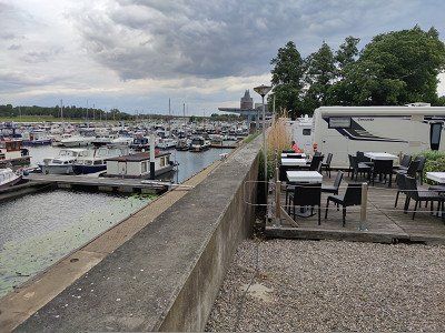
https://www.promobil.de/stellplatz/wohnmobilhafen-heimbach-588f207a721d54a528162585.html
Being right next to the train station is of course practical, but also noisy when the trains come. But not many come and at night we don't hear anything. The road directly next to it is also so busy that it bothers us.
Rugged rock formations, castles and wildly towering rock towers as well as a gently undulating Börde landscape with arable land and artificially created arms of the river characterize this stage. Düren with its 1950s charm, Jülich with its fortifications and Indeland, which is in the midst of a structural change from opencast lignite mining to a new landscape, also characterize this stage of the RurUfer cycle path.
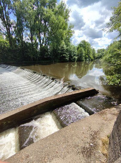
From Heimbach it goes along the northern part of the national park and below the towering red sandstone cliffs of Nideggen to the last reservoir of the Rur. Be sure to check out the fish ladder at Obermaubach, which will allow migratory fish to resume their normal life cycle in the spawning waters of the upper reaches of the river. After that, the mountains disappear and large alluvial forests line the Rur to Düren. A detour to the district town is worthwhile to take a break at the traffic-calmed market square or to visit one of the museums. We continue to Julich. At least three special features await you there. Before reaching the city, a visit to the Inden open-cast lignite mine is tempting. This can be circumnavigated with a 12 km long loop. The steel Indemann invites you to climb and enjoy a magnificent all-round view.
In Jülich, be sure to visit the Renaissance citadel and the Bridgehead Park from Napoleonic times. Here the third stage can be finished.
Distance 48.8 km
Duration 3:30 h
Ascent 77 m
Descent 208 m
Highest point 221 m
Lowest point77 hm
Source: outdooractive.com
Since the mobile home port in Heimbach is right next to the train station and Jülich also has a train station, it makes sense here to complete the stage and catch up with the mobile home by taking public transport back. This also worked very well, but took a little over 2.5 hours.
Rugged rock formations, castles and wildly towering rock towers as well as a gently undulating Börde landscape with arable land and artificially created arms of the river characterize this stage. Düren with its 1950s charm, Jülich with its fortifications and Indeland, which is in the midst of a structural change from opencast lignite mining to a new landscape, also characterize this stage of the RurUfer cycle path.
From Heimbach it goes along the northern part of the national park and below the towering red sandstone cliffs of Nideggen to the last reservoir of the Rur. Be sure to check out the fish ladder at Obermaubach, which will allow migratory fish to resume their normal life cycle in the spawning waters of the upper reaches of the river. After that, the mountains disappear and large alluvial forests line the Rur to Düren. A detour to the district town is worthwhile to take a break at the traffic-calmed market square or to visit one of the museums. We continue to Julich. At least three special features await you there. Before reaching the city, a visit to the Inden open-cast lignite mine is tempting. This can be circumnavigated with a 12 km long loop. The steel Indemann invites you to climb and enjoy a magnificent all-round view.
In Jülich, be sure to visit the Renaissance citadel and the Bridgehead Park from Napoleonic times. Here the third stage can be finished.
Distance 48.8 km
Duration 3:30 h
Ascent 77 m
Descent 208 m
Highest point 221 m
Lowest point77 hm
Source: outdooractive.com
Since the mobile home port in Heimbach is right next to the train station and Jülich also has a train station, it makes sense here to complete the stage and catch up with the mobile home by taking public transport back. This also worked very well, but took a little over 2.5 hours.
https://www.promobil.de/stellplatz/stellplatz-am-brueckenkopf-park-588f200b721d54a528161b7b.html
Sufficient space, even for very large and giant vehicles. It's a bit of a stretch in the city. Bike is an advantage
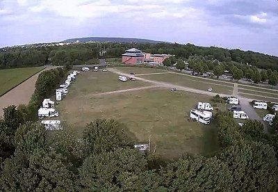
https://www.promobil.de/stellplatz/stellplatz-am-brueckenkopf-park-588f200b721d54a528161b7b.html
Sufficient space, even for very large and giant vehicles. It's a bit of a stretch in the city. Bike is an advantage
The country becomes flatter and flatter, the Rur calmer and the journey more leisurely the further north you go. Linnich holds the glass painting museum and then it goes on to the Heinsberger Land. You drive between meadows and pastures through the wide floodplain landscape, past mansions and moated castles (Haus Großkünkel, Haus Kleinkünkel, Rittergut Grittern, Burg Wassenberg, Haus Effelt), idyllic small towns and various lakes (Adolfosee in Ratheim, Effelder Waldsee). The Hilfarth district of Hückelhoven was known in earlier times for the production of woven baskets and other objects made of willow branches. In the past, the basket-making villages lined up like a string of pearls. The museum in Hückelhoven-Hilfarth tells the history of basket making on the Rur and invites visitors to join in. Winding towers and tailings dumps in Hückelhoven and Ratheim, on the other hand, are reminiscent of the former Sophia-Jacoba colliery and the importance of hard coal mining in the region. At the end of the tour, you cross the border in the direction of Roermond, which invites you to stroll and stroll with its numerous shops and cafés.
Distance 56.2 km
Duration 2:30 h
Ascent 49 m
Descent 92 m
Highest point79 hm
Lowest point 17 m
Source: outdooractive.com
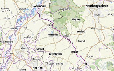
We have planned about half of stage three. This is the town of Hückelhofen. The route had no significant highlights and neither did Hückelhofen. That's why we had enough time to move to Roermond, where we had reserved - and that was a good thing.
We have planned about half of stage three. This is the town of Hückelhofen. The route had no significant highlights and neither did Hückelhofen. That's why we had enough time to move to Roermond, where we had reserved - and that was a good thing.
https://www.promobil.de/stellplatz/camperplaats-helenawerf-588f1d5d721d54a52815d2b6.html
Being able to reserve here is a big advantage. Otherwise we would probably have been very far out of town. The prices are decent. But we also stood here nice and quiet.
https://www.promobil.de/stellplatz/camperplaats-helenawerf-588f1d5d721d54a52815d2b6.html
Being able to reserve here is a big advantage. Otherwise we would probably have been very far out of town. The prices are decent. But we also stood here nice and quiet.
However, we turned around shortly before because the Father's Day hustle and bustle in Germany was much heavier than in the Dutch section of our tour.
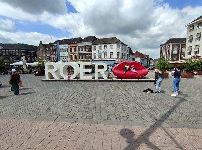
We then paid a visit to the Roermond designer outlet and ended our Rur tour with it.
However, we turned around shortly before because the Father's Day hustle and bustle in Germany was much heavier than in the Dutch section of our tour.
We then paid a visit to the Roermond designer outlet and ended our Rur tour with it.
Route
Show newest first- 50.52 6.2059
- 50° 31' 12.2" N 6° 12' 21.1" E
Wer sich zu Rurquelle im belgischen Venn begibt glaubt zunächst nicht, dass dieser verwunschene Ort nur wenige Kilometer von Aachen, Eupen oder Lüttich entfernt liegt. Hier, am höchsten Punkt Belgiens erwartet den Besucher ein ungewöhnlicher Lebensraum und ein in Mitteleuropa einzigartiges Ökosystem, ein Hochmoor ungewöhnlicher Größe. Das Städtchen Monschau lädt jeden Radfahrer ein, zu rasten, die Innenstadt zu erkunden und Flair der ehemaligen Hochburg der Tuchermacherei zu genießen. Durch das tiefe Kerbtal der Rur geht es Richtung Rurseenplatte. Hoch aufragende Schieferfelsen begleiten die kleine Straße und die sich anschließenden abseits gelegenen Wege, die durch das Tal bis Einruhr führen.
Der nächste Abschnitt des RurUfer-Radweges thematisiert neben den großen aufgestauten Wasserflächen den einzigen Nationalpark in NRW, den Nationalpark-Eifel. Sie erleben das Revier, in dem Wildkatze, Spechte und Mauereidechsen das Sagen haben und wo der Mensch „Natur Natur sein lässt“. Der RurUfer-Radweg läuft entlang der beiden Ufer des Rursees. Die Strecke rechts des Ufers durchquert den Nationalpark, links herum treffen Sie noch auf den Wassersportort Woffelsbach, bevor Sie den Zielort Heimbach erreichen.
Strecke 65,3 km
Dauer 4:30 h
Aufstieg 303 hm
Abstieg 793 hm
Höchster Punkt 693 hm
Tiefster Punkt 204 hm
Quelle: outdooractive.com
Ausgehend vom Bahnhof Kalterherberg fahren wir zunächst an der alten Bahnlinie um dann den Startpunkt des RurUfer-Radweges Signal de Botrange zu erreichen.
Auf dem gleichen Weg wieder zurück und weiter nach Monschau. Der Plan war, dass nur ich zurückfahre um das Womo zu holen und den Stellplatz in Monschau für die nächste Übernachtung zu nutzen.
Nachdem wir den Stellplatz Monschau https://www.promobil.de/stellplatz/stellplatz-am-vennbad-5a143c59f28b876f71468351.html gesehen haben disponierten wir um und fuhren nach Ruhrberg.
- 50.6069 6.3799
- 50° 36' 25" N 6° 22' 47.8" E
Zurück nach Monschau geht es durch ein schmales Tal, das sich die Rur hier gegraben hat.
Viel Fachwerk und schöne alte Häuser lassen erahnen, dass in Monschau mal viel Geld verdient wurde. Die Stadt ist gut erhalten und lebt heute vom Tourismus.
Wieder zurück am Rursee haben wir es hier mit einer ganz anderen Landschaft zu tun. Klar, der Mensch hat eingegriffen und diesen See aufgestaut. Mit vielen Seitenarmen, die wohl durch einige Zuflüsse gestaltet wurden geht es nach Heimbach. Als Weg zurück zum Stellplatz nutzen wir hier als kleine Abkürzung die andere Seeseite.
Anschließend setzen wir noch um nach Heimbach.
- 50.6364 6.4731
- 50° 38' 11" N 6° 28' 23" E
Zerklüftete Gesteinsformationen, Burgen und wild aufragende Felstürme sowie eine sanft gewellte Börde-Landschaft mit Ackerflächen und künstlich angelegten Flussarmen stecken diese Etappe ab. Düren mit seinem 50er Jahre-Charme, Jülich mit seinen Festungsbauwerken sowie das Indeland, das sich mitten im Strukturwandel vom Braunkohletagebau zu einer neuen Landschaft befindet prägen des Weiteren diese Etappe des RurUfer-Radwegs.
Von Heimbach geht es entlang des nördlichen Teiles im Nationalpark und unterhalb der hoch aufragenden Buntsandsteinfelsen Nideggens zum letzten Stausee der Rur. Unbedingt anschauen sollten Sie die Fischtreppe in Obermaubach, die es Wanderfischen ermöglichen wird, ihren normalen Lebenszyklus in die Laichgewässer der oberen Flussabschnitte wieder aufzunehmen. Danach verschwinden die Berge und große Auwälder umsäumen die Rur bis Düren. Ein Abstecher in die Kreisstadt lohnt, um dort am verkehrsberuhigten Marktplatz zu pausieren oder eines der Museen zu besuchen. Weiter geht es nach Jülich. Dort warten mindestens drei Besonderheiten. Bevor die Stadt erreicht wird, reizt der Besuch des Braunkohletagebaues Inden. Dieser kann mit einer 12 km langen Schleife umrundet werden. Der stählerne Indemann lädt zum Aufstieg und zu einem grandiosen Rundumblick.
In Jülich unbedingt auch die Zitadelle aus der Renaissance und den Brückenkopf-Park aus napoleonischer Zeit besuchen. Hier kann die dritte Etappe beendet werden.
Strecke 48,8 km
Dauer 3:30 h
Aufstieg 77 hm
Abstieg 208 hm
Höchster Punkt 221 hm
Tiefster Punkt77 hm
Quelle: outdooractive.com
Da der Wohnmobilhafen in Heimbach direkt am Bahnhof liegt und Jülich ebenfall einen Bahnhof hat, bietet es sich hier an, die Etappe komplett zu fahren und das Womo nachzuholen, indem einer mit dem ÖPNV zurück fährt. Dies hat auch sehr gut funktioniert, aber etwas mehr als 2,5 h gedauert.
- 50.9233 6.3406
- 50° 55' 24" N 6° 20' 26" E
- 51.058 6.2227
- 51° 3' 28.8" N 6° 13' 21.6" E
- 51.0626 6.0889
- 51° 3' 45.5" N 6° 5' 20.1" E
Das Land wird immer flacher, die Rur immer ruhiger und die Fahrt immer gemütlicher, je weiter man nach Norden kommt. Linnich hält das Glasmalerei-Museum vor und dann geht es auch schon weiter ins Heinsberger Land. Sie fahren zwischen Wiesen und Weiden durch die weite Flussauenlandschaft, vorbei an Herrenhäusern und Wasserschlösschen (Haus Großkünkel, Haus Kleinkünkel, Rittergut Grittern, Burg Wassenberg, Haus Effelt), idyllischen kleinen Orten und verschiedenen Seen (Adolfosee in Ratheim, Effelder Waldsee). Der Hückelhovener Ortsteil Hilfarth war in früheren Zeiten für die Herstellung von geflochtenen Körben und anderen Gegenständen aus Weidenzweigen bekannt. Wie eine Perlenkette reihten sich die Korbmacherdörfer in früheren Jahren aneinander. Das Museum in Hückelhoven-Hilfarth erzählt die Geschichte der Korbmacherei an der Rur und lädt die Besucher zum Mitmachen ein. Fördertürme und Bergehalden in Hückelhoven und Ratheim erinnern dagegen an die ehemaligen Zeche Sophia-Jacoba und die Bedeutung des Steinkohlebergbaus in der Region. Zum Ende der Tour geht es dan über die Grenze Richtung Roermond, das mit seinen zahlreichen Geschäften und Cafés zum Bummeln und flanieren einlädt.
Strecke 56,2 km
Dauer 2:30 h
Aufstieg 49 hm
Abstieg 92 hm
Höchster Punkt79 hm
Tiefster Punkt 17 hm
Quelle: outdooractive.com
ca. die Hälfte der Etappe drei haben wir uns vorgenommen. Das ist die Stadt Hückelhofen. Die Strecke hatte keine wesentlichen Highlights und Hückelhofen auch nicht. Deswegen hatten wir ausreichend Zeit nach Roermond umzusetzen, wo wir reserviert hatten - und das war auch gut so.
- 51.1938 5.9801
- 51° 11' 37.6" N 5° 58' 48.4" E
wir haben jedoch kurz vorher schon wieder umgedreht, da der Vatertagstrubel in D doch viel heftiger war als im niederländischen Abschnitt unserer Tour.
Wir haben dann noch dem Designeroutlet Roermond einen Besuch abgestattet und unsere Rur-Tour damit abgeschlossen.
Travelogue
is now used as a trolley station. Good starting point for the journey to the starting point of the first stage.
Have big parking lot. NO designated WOMO parking space. We stayed there and it didn't bother anyone.
is now used as a trolley station. Good starting point for the journey to the starting point of the first stage.
Have big parking lot. NO designated WOMO parking space. We stayed there and it didn't bother anyone.
Anyone who goes to Rurquelle in the Belgian Fagnes will not initially believe that this enchanted place is only a few kilometers away from Aachen, Eupen or Liège. Here, at the highest point in Belgium, visitors can expect an unusual habitat and an ecosystem that is unique in Central Europe, a raised bog of an unusual size. The town of Monschau invites every cyclist to take a rest, explore the city center and enjoy the flair of the former stronghold of cloth making. Through the deep notched valley of the Rur we head towards the Rurseenplatte. Towering slate rocks accompany the small road and the subsequent off-road paths that lead through the valley to Einruhr.
The next section of the RurUfer cycle path focuses on the only national park in NRW, the Eifel National Park, in addition to the large dammed water areas. You will experience the area where wild cats, woodpeckers and wall lizards call the shots and where people "let nature be nature". The RurUfer cycle path runs along both banks of the Rursee. The route to the right of the bank crosses the national park, to the left you will come across the water sports resort of Woffelsbach before you reach your destination, Heimbach.
Distance 65.3 km
Duration 4:30 h
Ascent 303 m
Descent 793 m
Highest point 693 m
Lowest point 204 m
Source: outdooractive.com
Starting from Kalterherberg train station, we first ride on the old railway line to then reach the starting point of the Signal de Botrange cycle path on the banks of the Rur.
Back the same way and on to Monschau. The plan was that only I would drive back to get the camper and use the parking space in Monschau for the next night.
After seeing the Monschau parking space https://www.promobil.de/stellplatz/stellplatz-am-vennbad-5a143c59f28b876f71468351.html we changed our plans and drove to Ruhrberg.
https://www.promobil.de/stellplatz/wohnmobilstellplatz-rurberg-588f1ff7721d54a528161964.html
Beautifully situated at the bathing lake. Has everything a decent pitch needs, except a baker. Unfortunately quite expensive.
https://www.promobil.de/stellplatz/wohnmobilstellplatz-rurberg-588f1ff7721d54a528161964.html
Beautifully situated at the bathing lake. Has everything a decent pitch needs, except a baker. Unfortunately quite expensive.
Back to Monschau it goes through a narrow valley that the Rur dug here.
A lot of half-timbering and beautiful old houses give an idea that a lot of money was once made in Monschau. The city is well preserved and now lives from tourism.
Back at the Rursee we are dealing with a completely different landscape. Of course, man intervened and dammed this lake. With many side arms, which were probably formed by some tributaries, it goes to Heimbach. As a way back to the parking space, we use the other side of the lake as a small shortcut.
Then we transfer to Heimbach.
https://www.promobil.de/stellplatz/wohnmobilhafen-heimbach-588f207a721d54a528162585.html
Being right next to the train station is of course practical, but also noisy when the trains come. But not many come and at night we don't hear anything. The road directly next to it is also so busy that it bothers us.
Rugged rock formations, castles and wildly towering rock towers as well as a gently undulating Börde landscape with arable land and artificially created arms of the river characterize this stage. Düren with its 1950s charm, Jülich with its fortifications and Indeland, which is in the midst of a structural change from opencast lignite mining to a new landscape, also characterize this stage of the RurUfer cycle path.
From Heimbach it goes along the northern part of the national park and below the towering red sandstone cliffs of Nideggen to the last reservoir of the Rur. Be sure to check out the fish ladder at Obermaubach, which will allow migratory fish to resume their normal life cycle in the spawning waters of the upper reaches of the river. After that, the mountains disappear and large alluvial forests line the Rur to Düren. A detour to the district town is worthwhile to take a break at the traffic-calmed market square or to visit one of the museums. We continue to Julich. At least three special features await you there. Before reaching the city, a visit to the Inden open-cast lignite mine is tempting. This can be circumnavigated with a 12 km long loop. The steel Indemann invites you to climb and enjoy a magnificent all-round view.
In Jülich, be sure to visit the Renaissance citadel and the Bridgehead Park from Napoleonic times. Here the third stage can be finished.
Distance 48.8 km
Duration 3:30 h
Ascent 77 m
Descent 208 m
Highest point 221 m
Lowest point77 hm
Source: outdooractive.com
Since the mobile home port in Heimbach is right next to the train station and Jülich also has a train station, it makes sense here to complete the stage and catch up with the mobile home by taking public transport back. This also worked very well, but took a little over 2.5 hours.
https://www.promobil.de/stellplatz/stellplatz-am-brueckenkopf-park-588f200b721d54a528161b7b.html
Sufficient space, even for very large and giant vehicles. It's a bit of a stretch in the city. Bike is an advantage
https://www.promobil.de/stellplatz/stellplatz-am-brueckenkopf-park-588f200b721d54a528161b7b.html
Sufficient space, even for very large and giant vehicles. It's a bit of a stretch in the city. Bike is an advantage
The country becomes flatter and flatter, the Rur calmer and the journey more leisurely the further north you go. Linnich holds the glass painting museum and then it goes on to the Heinsberger Land. You drive between meadows and pastures through the wide floodplain landscape, past mansions and moated castles (Haus Großkünkel, Haus Kleinkünkel, Rittergut Grittern, Burg Wassenberg, Haus Effelt), idyllic small towns and various lakes (Adolfosee in Ratheim, Effelder Waldsee). The Hilfarth district of Hückelhoven was known in earlier times for the production of woven baskets and other objects made of willow branches. In the past, the basket-making villages lined up like a string of pearls. The museum in Hückelhoven-Hilfarth tells the history of basket making on the Rur and invites visitors to join in. Winding towers and tailings dumps in Hückelhoven and Ratheim, on the other hand, are reminiscent of the former Sophia-Jacoba colliery and the importance of hard coal mining in the region. At the end of the tour, you cross the border in the direction of Roermond, which invites you to stroll and stroll with its numerous shops and cafés.
Distance 56.2 km
Duration 2:30 h
Ascent 49 m
Descent 92 m
Highest point79 hm
Lowest point 17 m
Source: outdooractive.com
We have planned about half of stage three. This is the town of Hückelhofen. The route had no significant highlights and neither did Hückelhofen. That's why we had enough time to move to Roermond, where we had reserved - and that was a good thing.
We have planned about half of stage three. This is the town of Hückelhofen. The route had no significant highlights and neither did Hückelhofen. That's why we had enough time to move to Roermond, where we had reserved - and that was a good thing.
https://www.promobil.de/stellplatz/camperplaats-helenawerf-588f1d5d721d54a52815d2b6.html
Being able to reserve here is a big advantage. Otherwise we would probably have been very far out of town. The prices are decent. But we also stood here nice and quiet.
https://www.promobil.de/stellplatz/camperplaats-helenawerf-588f1d5d721d54a52815d2b6.html
Being able to reserve here is a big advantage. Otherwise we would probably have been very far out of town. The prices are decent. But we also stood here nice and quiet.
However, we turned around shortly before because the Father's Day hustle and bustle in Germany was much heavier than in the Dutch section of our tour.
We then paid a visit to the Roermond designer outlet and ended our Rur tour with it.
However, we turned around shortly before because the Father's Day hustle and bustle in Germany was much heavier than in the Dutch section of our tour.
We then paid a visit to the Roermond designer outlet and ended our Rur tour with it.
Comments (0)
Comments from Freeontour users