Unfortunately, we don't support your browser (Internet Explorer) anymore, some functionalities could not work. Click here to get information on how to upgrade your browser.
Norway - Sweden

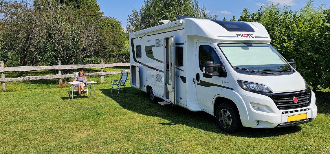
Travelogue
Pick up package for Norway.
Pick up package for Norway.
motorhome contact 62605
Great, free!, place to stay overnight on your way to Denmark. Groceries (large supermarket) and breakfast (at the bakery) across the street in the shopping center. The toilets in the shopping center can be used during opening hours. at night it is quiet and you are back on the highway in a few minutes.
https://www.citti-park-flensbu...
Site code: 9923
Bredkærvej 89
9800, Hjorring, Denmark
57° 26' 26" N
10° 3' 26" E
57.44059
10.05735
Site code: 9923
Bredkærvej 89
9800, Hjorring, Denmark
57° 26' 26" N
10° 3' 26" E
57.44059
10.05735
Alternative 48625
Tornby Strand Camping Hirtshals, Denmark
Alternative 48625
Tornby Strand Camping Hirtshals, Denmark
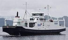
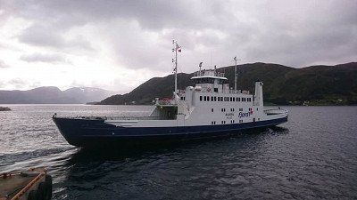
Crossing takes 2 hours and 15 minutes.
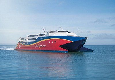
Crossing takes 2 hours and 15 minutes.
Deliver package to family.
Deliver package to family.
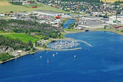
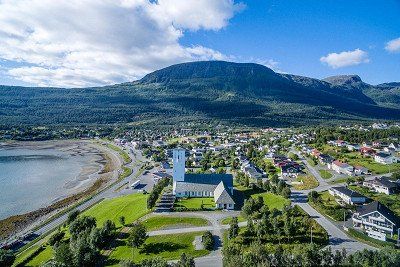
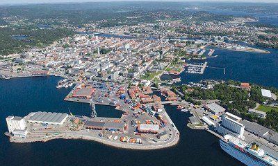
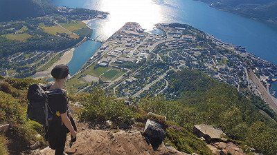
Arendal is a town in the Arendal municipality in the Norwegian county of Agder in southern Norway. In the center is the Tyholmen area with wooden houses from around 1600. The harbor is called Pollen, where you can find the fish market, cafes and restaurants.
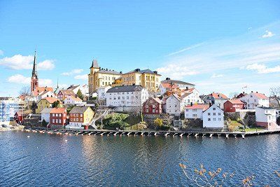
Arendal is a town in the Arendal municipality in the Norwegian county of Agder in southern Norway. In the center is the Tyholmen area with wooden houses from around 1600. The harbor is called Pollen, where you can find the fish market, cafes and restaurants.
Åmli is a village and municipality in fylke Agder in Norway. It is a typical rural community that largely consists of forest. In January 2017, Åmli had 1,856 inhabitants. The board is located in the village of Åmli, where about 600 people live.
Åmli is a village and municipality in fylke Agder in Norway. It is a typical rural community that largely consists of forest. In January 2017, Åmli had 1,856 inhabitants. The board is located in the village of Åmli, where about 600 people live.
Treungen is a village in and the administrative center of Nissedal Municipality, Telemark County in Norway. Located just east of the village of Tveitsund, it is part of the urban area of the same name, which has a population of 361 as of January 1, 2009.
Treungen is a village in and the administrative center of Nissedal Municipality, Telemark County in Norway. Located just east of the village of Tveitsund, it is part of the urban area of the same name, which has a population of 361 as of January 1, 2009.
Brunkeberg is a village in Kviteseid Municipality in Vestfold og Telemark County, Norway. The European route E134 which runs from Drammen to Haugesund passes through the village. The Brunkebergkerk is a white cruciform church from 1790
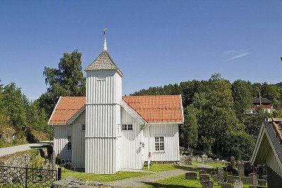
Brunkeberg is a village in Kviteseid Municipality in Vestfold og Telemark County, Norway. The European route E134 which runs from Drammen to Haugesund passes through the village. The Brunkebergkerk is a white cruciform church from 1790
Vinje is a municipality in Vestfold og Telemark county in southern Norway. The municipality had 3,726 inhabitants in January 2017.
Vinje is located in the Hjart valley, southeast of the plateau Hardangervidda. It borders Nore og Uvdal to the north, Tinn and Seljord to the east, Tokke and Bykle to the south, and Suldal, Odda and Ullensvang to the west.
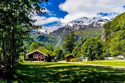
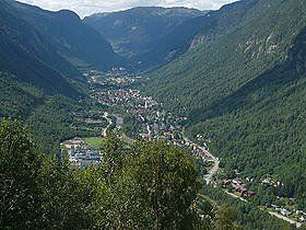
Rjukan is a place in the municipality of Tinn in the county of Vestfold og Telemark in Norway. It is one of the few cities in Norway designed on the drawing board.
THE VILLAGE OF RJUKAN IN TELEMARK, SOUTH NORWAY
The town of Rjukan is located near the Hardanger National Park and is known for the famous Gaustatoppen (1833 meters) and its important role in the Second World War. Museums It with exhibitions about the industrial development of Norway and Rjukan in particular. Very special is the exhibition about Rjukan in the Second World War, especially about the resistance fighters who sabotaged the German plans to develop an atomic bomb in Vemork. The Tinn Museum, an open-air museum with buildings from the 16th to the 20th century. The mountain farms are still working as before. The Tinn Håndverksenter is a combination of art and home crafts exhibitions. Cable car Kitelsen. Very special is the Krossobanen, the first funicular in Northern Europe, built in 1928 and built for the population so that they could see the sun in winter. The cable car takes you to an altitude of 866 meters. At the top you have a beautiful view. www.krossobanen.no(link is external)
Nature
First of all, the Gaustatoppen with a height of 1883 meters above sea level. In clear weather you can see a sixth part of Norway! You can also take a train up to 860 meters up the mountain. The Hardangervidda is a vast mountain plateau, an untouched wilderness. The largest herd of wild reindeer in Northern Europe lives here. A beautiful area for the experienced hiker. The Rjukan Waterfall is 104 meters high and definitely worth a visit.
Left to the north follow the Tessungdalen to the main road to GEILO
Geilo is a town in the county of Viken in southern Norway with about 2300 inhabitants. Geilo belongs to the municipality of Hol. It is located on the lake Ustedalsfjorden. Geilo is best known as a ski area, with 39 slopes, 20 ski lifts and about 220 km of cross-country trails.
Geilo is a town in the county of Viken in southern Norway with about 2300 inhabitants. Geilo belongs to the municipality of Hol. It is located on the lake Ustedalsfjorden. Geilo is best known as a ski area, with 39 slopes, 20 ski lifts and about 220 km of cross-country trails.
Gol is a municipality in the Norwegian province of Viken. The municipality had 4612 inhabitants in January 2017. Gol borders Ål, Hemsedal and Nes and Nord-Aurdal and Sør-Aurdal in Oppland county.
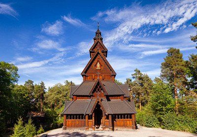
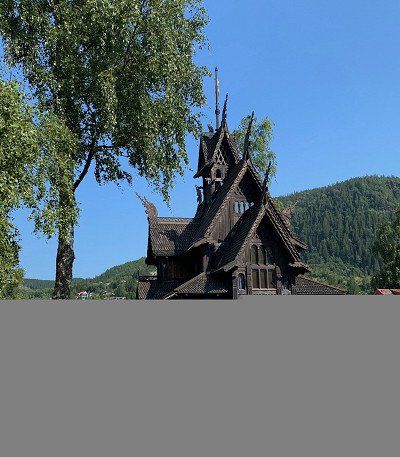
Located in the medieval park Gordarike, the Gol Stave Church is a faithful copy of the Gol Stave Church built in the 1200s. The example was built in the 1980s and consecrated by the Bishop of Tunsberg in 1994. summer evening on Wednesdays there is a devotional and sometimes musical performance. The church is often used for weddings. The woodwork in the church is still bright and it's easy to see all the beautiful carvings and details. Visit the church and be humbled by the mood with which you are greeted. Inside you can listen to the beautiful Gregorian choral music (CD). You can study the stave church architecture in the Viking Hall next to the exhibition. Same opening hours/entrance ticket as for the Gordarike Family Park. Gol Stave Church (Gol stavkirke) is a stave church originally from Gol, Hallingdal, Norway. It is now located in the Norwegian Museum of Cultural History in Bygdøy in Oslo, Norway. When the city built a new church around 1880, it was decided to demolish the old stave church. It was saved from destruction by the Society for the Preservation of Ancient Norwegian Monuments, who bought the materials to rebuild the church elsewhere. It was purchased by King Oscar II, who financed its relocation and restoration as the central building of his private open-air museum near Oslo. The restoration, overseen by architect Waldemar Hansteen, was completed in 1885. In 1907 this early open-air museum, the world's first, was merged with the Norwegian Museum of Cultural History, which now manages the stave church, still nominally owned by the reigning monarch . The church is dendrochronologically dated to 1212. In the 1980s,
Gol is a municipality in the Norwegian province of Viken. The municipality had 4612 inhabitants in January 2017. Gol borders Ål, Hemsedal and Nes and Nord-Aurdal and Sør-Aurdal in Oppland county.
Located in the medieval park Gordarike, the Gol Stave Church is a faithful copy of the Gol Stave Church built in the 1200s. The example was built in the 1980s and consecrated by the Bishop of Tunsberg in 1994. summer evening on Wednesdays there is a devotional and sometimes musical performance. The church is often used for weddings. The woodwork in the church is still bright and it's easy to see all the beautiful carvings and details. Visit the church and be humbled by the mood with which you are greeted. Inside you can listen to the beautiful Gregorian choral music (CD). You can study the stave church architecture in the Viking Hall next to the exhibition. Same opening hours/entrance ticket as for the Gordarike Family Park. Gol Stave Church (Gol stavkirke) is a stave church originally from Gol, Hallingdal, Norway. It is now located in the Norwegian Museum of Cultural History in Bygdøy in Oslo, Norway. When the city built a new church around 1880, it was decided to demolish the old stave church. It was saved from destruction by the Society for the Preservation of Ancient Norwegian Monuments, who bought the materials to rebuild the church elsewhere. It was purchased by King Oscar II, who financed its relocation and restoration as the central building of his private open-air museum near Oslo. The restoration, overseen by architect Waldemar Hansteen, was completed in 1885. In 1907 this early open-air museum, the world's first, was merged with the Norwegian Museum of Cultural History, which now manages the stave church, still nominally owned by the reigning monarch . The church is dendrochronologically dated to 1212. In the 1980s,
Leira is a place in the Norwegian municipality of Nord-Aurdal, province of Innlandet. Leira has 788 inhabitants (2007) and has an area of 1.22 km².
Leira is a place in the Norwegian municipality of Nord-Aurdal, province of Innlandet. Leira has 788 inhabitants (2007) and has an area of 1.22 km².
From here a small road to the north east to GAUSDAL SEGELSTAD- BRU
From here a small road to the north east to GAUSDAL SEGELSTAD- BRU
Segalstad bru is a place in Gausdal Municipality, Innlandet County, Norway. Segalstad bru has 862 inhabitants and has an area of 1.17 km². It is the main town of the municipality.
Segalstad bru is a place in Gausdal Municipality, Innlandet County, Norway. Segalstad bru has 862 inhabitants and has an area of 1.17 km². It is the main town of the municipality.
From here road nr: 255 north west to VINSTRA then south east to the north of RINGEBU
From here road nr: 255 north west to VINSTRA then south east to the north of RINGEBU
Ringebu is a municipality and ski resort in Gudbrandsdal in the Norwegian county of Innlandet. Ringebu borders Sør-Fron to the northwest, Gausdal to the southwest, Øyer to the south and Stor-Elvdal in Hedmark County to the east. Ringebu is located at 182 meters above sea level.
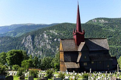
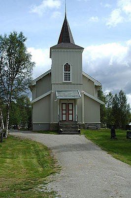
About Ringebu Stave Church Built in about 1220, this distinctive and much-photographed stave church is one of only 28 remaining in Norway. Once common, more than 1000 scattered across the countryside, with their unique style of architecture and construction, and they are symbolic of old Norway. Christianity was introduced to Norway around 1000 AD and about a thousand stave churches were built in the years that followed.
The original church was renovated in the 17th century when the distinctive red tower was added, and while the interior was painted white at one point, the original color has since been restored.
Ringebu Stave Church and the surrounding cemetery, amid hills and farmland, are strikingly beautiful, with immaculate grounds. A thoughtful touch is provided by the watering cans left at each tap for the use of people tending the graves, and these are clearly put to good use. Nearly every grave on the property has been planted with a small garden, and all are still lovingly maintained, making this a truly beautiful and distinctive resting place.
Traditionally built without the use of a single nail, they are composed of wood that has been skilfully swallowed, with vertical posts and wall planks resting on ground beams. Again, the use of tar to preserve the wood resulted in the loss and destruction by fire of many stave churches. Post holes have also been found here in Ringebu, indicating the presence of an even older church, with a cache of over 900 medieval coins found beneath the church, which have contributed to dating its construction.
The Rectory of Ringebu Built in 1743, the Rectory of Ringebu occupies a beautiful location north of the Ringebu Stave Church and was fully in use until 1991. Today, this monumental and restored rectory is a historic experience in itself. There are 5 buildings in the yard; the main building, two warehouses, staff quarters and an outbuilding.
Please note that the church may be closed in connection with church events, such as church services, weddings, funerals and the like
Ringebu is a municipality and ski resort in Gudbrandsdal in the Norwegian county of Innlandet. Ringebu borders Sør-Fron to the northwest, Gausdal to the southwest, Øyer to the south and Stor-Elvdal in Hedmark County to the east. Ringebu is located at 182 meters above sea level.
About Ringebu Stave Church Built in about 1220, this distinctive and much-photographed stave church is one of only 28 remaining in Norway. Once common, more than 1000 scattered across the countryside, with their unique style of architecture and construction, and they are symbolic of old Norway. Christianity was introduced to Norway around 1000 AD and about a thousand stave churches were built in the years that followed.
The original church was renovated in the 17th century when the distinctive red tower was added, and while the interior was painted white at one point, the original color has since been restored.
Ringebu Stave Church and the surrounding cemetery, amid hills and farmland, are strikingly beautiful, with immaculate grounds. A thoughtful touch is provided by the watering cans left at each tap for the use of people tending the graves, and these are clearly put to good use. Nearly every grave on the property has been planted with a small garden, and all are still lovingly maintained, making this a truly beautiful and distinctive resting place.
Traditionally built without the use of a single nail, they are composed of wood that has been skilfully swallowed, with vertical posts and wall planks resting on ground beams. Again, the use of tar to preserve the wood resulted in the loss and destruction by fire of many stave churches. Post holes have also been found here in Ringebu, indicating the presence of an even older church, with a cache of over 900 medieval coins found beneath the church, which have contributed to dating its construction.
The Rectory of Ringebu Built in 1743, the Rectory of Ringebu occupies a beautiful location north of the Ringebu Stave Church and was fully in use until 1991. Today, this monumental and restored rectory is a historic experience in itself. There are 5 buildings in the yard; the main building, two warehouses, staff quarters and an outbuilding.
Please note that the church may be closed in connection with church events, such as church services, weddings, funerals and the like
Then via road nr 27 which splits to FOLLDAL.
Then via road nr 27 which splits to FOLLDAL.
Folldal is a municipality in the Norwegian county of Innlandet. The municipality had 1,577 inhabitants in January 2017. Folldal borders Oppdal and Tynset in the north, Alvdal in the east, Stor-Elvdal, Sør-Fron and Sel in the south and Dovre in the west.
Rondane National Tourist Route is one of 18 selected road sections in Norway. It runs from Muen and Sollia Church to Folldal.
The road follows the east side of the Rondane National Park and switches between cultural landscape and a majestic mountain range. The drive along the Blue Mountains is a journey of discovery in nature, culture and geology. At Atnasjøen you can experience the mighty view from the Sohlbergplassen. Take a walk to Fallfossen and the old Grimsa Bridge or take a break in the Strømbu Rest Area. The Rest Area is the starting point for walks from the east and for mountain walks in Alvdal Vestfjell and Breisjøseter Tourist Cabin. In Folldal you can visit the old Mining Company and enjoy the panorama from the viewpoint.
FROM THE SOUTH
Gateway Ringebu: If you drove from Oslo on the E6 highway, the Rondane National Tourist Route can start from Ringebu. From there you can drive over the mountains, Venabygdsfjellet, and down where you can choose to head towards Hjerkinn in the west and Alvdal in the east.
Gateway Atna: If you are on route no. 3 from Elverum you can start from Atna and drive northwest. Here too you can choose whether you drive towards Hjerkinn or Alvdal.
FROM THE NORTH
Hjerkinn Port: Departing from Dovrefjell and west, Hjerkinn is an excellent gateway for your journey along the Rondanevegen. From the mountain plateau on Dovrefjell, the route leads to Folldal. After a few kilometers you can already see the contours of the Rondane mountains on the right.
Gateway Alvdal: If you're coming from the northeast and Røros or maybe from Sweden, start from Alvdal. While driving you will see the beginning of the Rondane mountains to the east and from Folldal you will drive through the characteristic landscape for which the Rondane mountains are known.
RONDANE National Park road no: 29 east to ALFDAL
RONDANE National Park road no: 29 east to ALFDAL
Alvdal is a village in Alvdal Municipality, Innlandet County, Norway. Alvdal has 667 inhabitants and has an area of 1.63 km². It is the seat of the municipal council. The village is located where the River Folla flows into the Glomma. The village has a station at Rørosbanen.
The largest gorge in Northern Europe, formed during the last ice age, about 10,000 years ago. You can experience the Jutulhogget Gorge on foot by descending the steep trail, or you can enjoy the view from the edge.
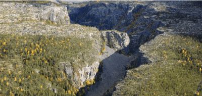
Then via the E3 to the north towards TYNSET
Then via the E3 to the north towards TYNSET
Tynset is a municipality in the Norwegian county of Innlandet. The municipality had 5584 inhabitants in January 2017. The municipal council is located in the town of the same name.
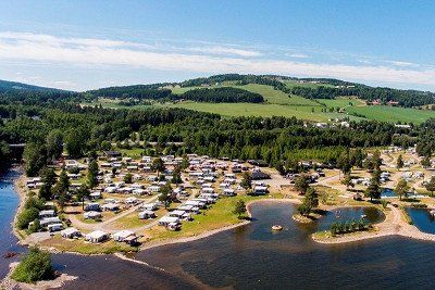
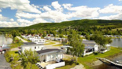
Tynset Rom & Camping is idyllically located next to the river "Glomma", directly over the bridge and centrally located in the center of Tynset. Here you will find accommodation in rooms, apartments and cabins, ranging from simple to luxurious. There is also a large site with electricity that can accommodate caravans, motorhomes and tents.
Tynset Rom & Camping is idyllically located next to the river "Glomma", directly over the bridge and centrally located in the center of Tynset. Here you will find accommodation in rooms, apartments and cabins, ranging from simple to luxurious. There is also a large site with electricity that can accommodate caravans, motorhomes and tents.
Tynset is a municipality in the Norwegian county of Innlandet. The municipality had 5584 inhabitants in January 2017. The municipal council is located in the town of the same name.
Tynset Rom & Camping is idyllically located next to the river "Glomma", directly over the bridge and centrally located in the center of Tynset. Here you will find accommodation in rooms, apartments and cabins, ranging from simple to luxurious. There is also a large site with electricity that can accommodate caravans, motorhomes and tents.
Tynset Rom & Camping is idyllically located next to the river "Glomma", directly over the bridge and centrally located in the center of Tynset. Here you will find accommodation in rooms, apartments and cabins, ranging from simple to luxurious. There is also a large site with electricity that can accommodate caravans, motorhomes and tents.
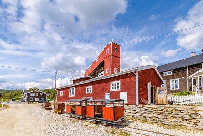
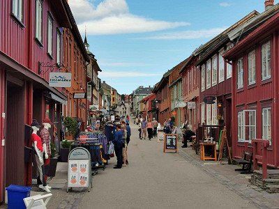
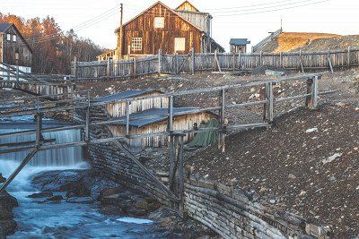
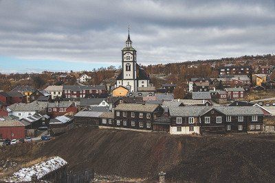
Røros is a town and municipality in the Norwegian county of Trøndelag. The municipality had 5623 inhabitants in January 2017. Røros is the highest town in Norway, at 628 meters above sea level. It has a station on Rørosbanen to Trondheim. Just west is the airport.
Røros is tucked away in inland Norway, not far from the border with Sweden. It is not an undiscovered village, as UNESCO listed it as a World Heritage Site in the 1980s, but arriving in Røros feels like walking into a fairytale, as if time has stood still here. Colorful wooden houses with white snowy roofs. Horse and carriage pass with ringing bells. Everywhere you look it is white and every house looks like you want to live there. A village from a winter fairytale.
It's actually quite special that people live in Røros, because it can get incredibly cold here. The record is about 50 degrees below zero, but on average it is minus 30 here in winter. The reason that Røros is still inhabited has to do with the history of the village. Long ago copper was discovered in the ground here and that turned out to be the jackpot. Røros and the surrounding area are now on the UNESCO World Heritage List for the mining history of this area.
To get there, you have to make a long journey, because it also takes about three hours by road from Trondheim (the nearest large city), but the nice thing is that the journey itself is a special experience in itself.
The figurehead of Røros is of course the striking church that can be seen from almost anywhere in the village. It was a gift from the mine bosses to the inhabitants of the village, with exactly as many seats as there were residents at the time. Nice to see inside and out, but the real nice part of Røros is of course the small streets downtown. Behind every door there is something special: a store with warm clothing or home accessories, a coffee bar to warm up with hot chocolate or maybe you step into a Norwegian cafe. Anyone who has ever seen Pippi Longstocking's films may recognize one of the streets. Not all wooden houses in the village are inhabited, but most of the windows have a poinsettia and so there is life indoors.
The mining museum
For a long time, life in this area was completely occupied by the copper mines. In the museum, in the middle of the old town, you can learn something about this time. You can see how incredibly hard it was for the miners here, because they had to work hard under harsh conditions. It is part of the history of Røros and is well worth a visit!
Breken, is a place and former municipality in Norway. The municipality was located in what was then Sør-Trøndelag County. The municipality was founded in 1926 as a split from Røros. In 1964 the municipality was again added to Røros. The old congregation still exists as a parish of the Norwegian Church.
Breken, is a place and former municipality in Norway. The municipality was located in what was then Sør-Trøndelag County. The municipality was founded in 1926 as a split from Røros. In 1964 the municipality was again added to Røros. The old congregation still exists as a parish of the Norwegian Church.
(to Myrmoen) then north on road mr: 705 from SELBU to ST JORDAL
(to Myrmoen) then north on road mr: 705 from SELBU to ST JORDAL
Selbu is a municipality in the Norwegian county of Trøndelag. The towns of Mevangen and Trøa are part of the municipality. The municipality had 4,098 inhabitants in January 2017. Surrounding municipalities are Tydal in the south and Malvik in the north.
Selbu is a municipality in the Norwegian county of Trøndelag. The towns of Mevangen and Trøa are part of the municipality. The municipality had 4,098 inhabitants in January 2017. Surrounding municipalities are Tydal in the south and Malvik in the north.
Stjørdal is a municipality in the Norwegian county of Trøndelag. The municipality had 23,625 inhabitants in January 2017. Stjørdal's coat of arms contains a tapeworm.
The Stjørdalsfjord is an arm of the Trondheimsfjord that extends east to the mouth of the Stjørdalselva River at the head of the fjord. The Stjørdal Delta has for the most part developed into Stjørdal town, industrial areas and an airport. Fragments of the original delta habitats are more or less intact, but still attract a number of wetland species during migration, both at the estuary and along the river.
NAFCamp camping - pitches on water - mini kiosk - supermarket 300m - center 750m.
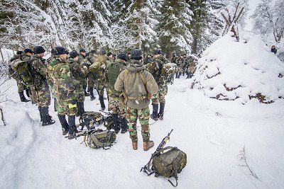
Was stationed here during its time as a Marine 1984 cold weather training.
NAFCamp camping - pitches on water - mini kiosk - supermarket 300m - center 750m.
Was stationed here during its time as a Marine 1984 cold weather training.
Bjerka is a place in Hemnes Municipality, Nordland County, Norway. Bjerka has 428 inhabitants and has an area of 0.89 km².
NAFCamp camping - pitches on water - mini kiosk - supermarket 300m - center 750m.
Bjerka is a place in Hemnes Municipality, Nordland County, Norway. Bjerka has 428 inhabitants and has an area of 0.89 km².
NAFCamp camping - pitches on water - mini kiosk - supermarket 300m - center 750m.
Mo i Rana is a town in Rana Municipality on the Ranfjord in Nordland in northern Norway. To the south is Mosjøen and to the north Fauske. It is the fourth largest city in northern Norway, with approximately 18,000 inhabitants. The city is located just south of the Arctic Circle at 66.5° N
Mo i Rana
Mo i Rana is a town in Rana Municipality on the Ranfjord in Nordland in northern Norway. The town is located north of Mosjøen and south of Fauske. It is the fourth largest city in northern Norway. The city is located just south of the Arctic Circle.
caves
Near Mo i Rana are more than 200 caves, the most famous of which are the Setergrotta and Grønli Cave. The latter is the most visited limestone cave in Norway.
Sights
In addition to a visit to the caves, a visit to the Arctic Circle Center is a good option. In addition, a visit to the Saltfjellet-Svartisen National Park with the Svartisen glacier and the Engabreen tributary is a must. For those interested, Mo i Rana is a branch of the National Library of Norway.
Mo i Rana Camping
Mo i Rana Camping is a campsite in Mo i Rana (Nordland, Norway), located a river/stream. The campsite is used by many people as a place to stay overnight on the way to the North Cape. The campsite has which are marked out and pitches without shade. It is possible to rent hikers' cabins, rooms and apartments. In the vicinity you can swim in the river/stream. It is possible to use the internet, because the campsite has one or more computers with an internet connection and there is a wifi point.
The Nordlandsbanen train route passes Mo i Rana and there is an airport, Mo i Rana Airport. Traffic and transport are done via the E6.
https://viatioga.nl/voorpret/b...
https://autopassferje.no/priser/
Torghatten Nord AS (torghatten-nord.no)
http://www.torghatten-nord.no

https://autopassferje.no/priser/
Torghatten Nord AS (torghatten-nord.no)
http://www.torghatten-nord.no
https://autopassferje.no/prise...
https://autopassferje.no/prise...
Narvik is a municipality in Nordland county in Norway that acquired city rights in 1902. The city has 18,630 inhabitants. With its location at 68° north latitude, it is the northernmost city in Europe with a railway station after Murmansk in Russia, which is slightly more northerly.
The town of Narvik is located in Northern Norway and is surrounded by majestic nature. High mountains tower over the blue Ofotfjord and are perfect for hiking and skiing. In winter, the Northern Lights dance across the sky at night, and the midnight sun makes for long, clear summer nights.
From Narvik you can hop on one of the most beautiful train journeys in the world on the Ofoten Railway. It was built by the navvies at the end of the 19th century. During the journey you can see traces of the Battle of Narvik which took place during the Second World War. You will learn more about it at the Narvik War Museum.
The Polar Park in Narvik is the northernmost zoo in the world. Admire animals such as wolves, lynx and bears, as well as reindeer, moose and arctic foxes.
Narvik is currently undergoing the process of obtaining the Sustainable Destination Certificate, a seal of approval awarded to destinations that systematically try to counteract the negative impact of tourism.
Detailed travel information can be found on Narvik's official website. https://www.visitnarvik.com/
Bjerkvik is a place in Narvik Municipality, Nordland County, Norway. Bjerkvik has 1195 inhabitants and has an area of 1.42 km². Bjervik includes hotels, supermarkets, rental car service and a comprehensive school with kindergarten, primary, secondary and gymnasium.
Bjerkvik is a place in Narvik Municipality, Nordland County, Norway. Bjerkvik has 1195 inhabitants and has an area of 1.42 km². Bjervik includes hotels, supermarkets, rental car service and a comprehensive school with kindergarten, primary, secondary and gymnasium.
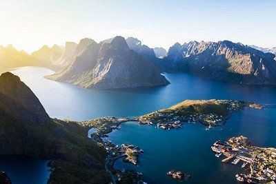
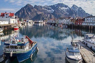
The Lofoten are an archipelago off the coast of Nordland county in northern Norway. The Lofoten consists of a number of islands. The best known are: Røst Værøy Gimsøya Moskenesøya Vestvågøy Austvågøy Flakstadøya Some places on the Lofoten are Svolvær, Leknes, Vågan, Ramberg, Moskenes and Reine.
The Lofoten
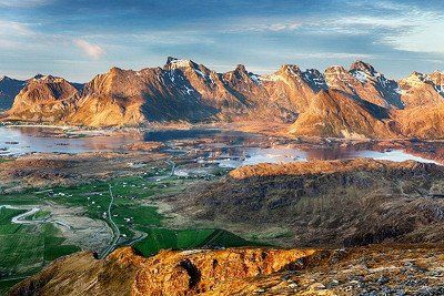
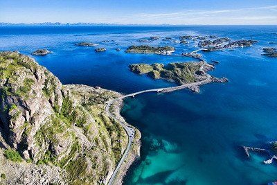
The Lofoten are sometimes jokingly referred to as 'the Norwegian Maldives'. The comparison lies in the unprecedented island splendor, because the weather is different here (although the cold is not too bad, see below!). The Lofoten are located well above the Arctic Circle in the middle of the North Sea. The landscape of the island archipelago is of pristine, magical beauty; an untouched wilderness full of wild mountain ranges, deep fjords, long sandy beaches and idyllic fishing villages with typical red houses. The Lofoten is also ideal for outdoor enthusiasts: you can go hiking, kayaking, rafting, whale watching, skiing, climbing, fishing and even surfing.
The main islands of Austvågøy, Vestvågøy, Flakstadøy and Moskenesøy are separated from the mainland by the sea of Vestfjorden, but are all connected by bridges and tunnels. One of the best ways to discover the islands is via the E10, a winding road that covers all corners of the islands.
Lofoten highlights and sights
The main attraction of Lofoten is the overwhelmingly beautiful landscape. Some of the best activities include kayaking in the golden midnight sun, rafting in the Trollfjord (where you'll almost certainly spot the mighty sea eagle, seals and countless seabirds!) and of course the Northern Lights safaris. Furthermore, there are countless remote characteristic fishing villages on the Lofoten with typical red fishermen's houses on the water (some of them converted into residential accommodation!). Of course you will find some of the best fishing waters on earth.
Lofoten towns and accommodation
The largest and most important town in Lofoten is Svolvær (population 5,000), which is also where the Hurtigruten (the famous Norwegian Coastal Express boat) moors. A bit more atmospheric is nearby Kabelvåg, which, like Svolvær, is located on the main island of Austvågøy. The town of Leknes (approx. 3000 inhabitants) on the central island of Vestvågøy is considered an unofficial 'capital town', it is also the only hospital in the region.
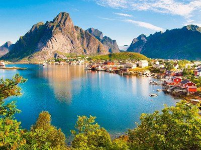
The village of Henningsvær is spread over several small islands, which is especially popular for its special location. Another much-photographed fishing village is the more remote and very picturesque Reine on Moskenesøy, arguably the prettiest of them all. Close to Reine – on a small island between two bridges – is the equally photogenic Hamnoy, with its beautiful harbor.
The Lofoten are an archipelago off the coast of Nordland county in northern Norway. The Lofoten consists of a number of islands. The best known are: Røst Værøy Gimsøya Moskenesøya Vestvågøy Austvågøy Flakstadøya Some places on the Lofoten are Svolvær, Leknes, Vågan, Ramberg, Moskenes and Reine.
The Lofoten
The Lofoten are sometimes jokingly referred to as 'the Norwegian Maldives'. The comparison lies in the unprecedented island splendor, because the weather is different here (although the cold is not too bad, see below!). The Lofoten are located well above the Arctic Circle in the middle of the North Sea. The landscape of the island archipelago is of pristine, magical beauty; an untouched wilderness full of wild mountain ranges, deep fjords, long sandy beaches and idyllic fishing villages with typical red houses. The Lofoten is also ideal for outdoor enthusiasts: you can go hiking, kayaking, rafting, whale watching, skiing, climbing, fishing and even surfing.
The main islands of Austvågøy, Vestvågøy, Flakstadøy and Moskenesøy are separated from the mainland by the sea of Vestfjorden, but are all connected by bridges and tunnels. One of the best ways to discover the islands is via the E10, a winding road that covers all corners of the islands.
Lofoten highlights and sights
The main attraction of Lofoten is the overwhelmingly beautiful landscape. Some of the best activities include kayaking in the golden midnight sun, rafting in the Trollfjord (where you'll almost certainly spot the mighty sea eagle, seals and countless seabirds!) and of course the Northern Lights safaris. Furthermore, there are countless remote characteristic fishing villages on the Lofoten with typical red fishermen's houses on the water (some of them converted into residential accommodation!). Of course you will find some of the best fishing waters on earth.
Lofoten towns and accommodation
The largest and most important town in Lofoten is Svolvær (population 5,000), which is also where the Hurtigruten (the famous Norwegian Coastal Express boat) moors. A bit more atmospheric is nearby Kabelvåg, which, like Svolvær, is located on the main island of Austvågøy. The town of Leknes (approx. 3000 inhabitants) on the central island of Vestvågøy is considered an unofficial 'capital town', it is also the only hospital in the region.
The village of Henningsvær is spread over several small islands, which is especially popular for its special location. Another much-photographed fishing village is the more remote and very picturesque Reine on Moskenesøy, arguably the prettiest of them all. Close to Reine – on a small island between two bridges – is the equally photogenic Hamnoy, with its beautiful harbor.
Beautiful resting place
Beautiful resting place
Let's make a cut here to the south.
From NARVIK to E10 over Sweden?
Let's make a cut here to the south.
From NARVIK to E10 over Sweden?
Sweden E10 Sakajärvi to the E45
Sweden E10 Sakajärvi to the E45
Jokkmokk is a town in northern Sweden and the administrative center of the municipality of the same name. The place is located about 5 kilometers inside the Arctic Circle. The town has 2976 inhabitants. The name Jokkmokk is a Swedish corruption of the Sami name, which means bend in the river.
Jokkmokk and the Sami
Jokkmokk has been a meeting and trading place for the Sami, the original inhabitants of Lapland, for centuries. Every year on the first Thursday, Friday and Saturday of February, Jokkmokks Marknad, a winter market, takes place. An age-old tradition, because this happened for the first time in 1605.
https://www.ishetnogver.nl/eur...
Östersund is a town in the municipalities of Östersund and Krokom in the Jämtland countryside and Jämtlands län county in Sweden. The city has 49,806 inhabitants and an area of 2684 hectares.
Östersund is a town in the municipalities of Östersund and Krokom in the Jämtland countryside and Jämtlands län county in Sweden. The city has 49,806 inhabitants and an area of 2684 hectares.
take the E14 west to STJORDAL - TRONDHEIM - ORKANGER road nr 71 or 65 to KRISTIANSUND
take the E14 west to STJORDAL - TRONDHEIM - ORKANGER road nr 71 or 65 to KRISTIANSUND
Trondheim is a city in the Norwegian county of Trøndelag. With 198 219 inhabitants, it is the third largest city in Norway. Trondheim is located on the Trondheimfjord. The Hurtigruten ferry service docks in the city's harbour.
https://allesovernoorwegen.nl/...
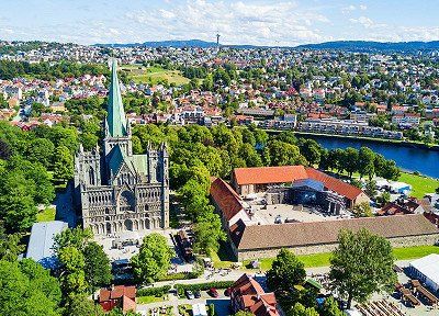
In ancient times, Trondheim was the capital of Norway and the center of the Norwegian Vikings. The city is located in the county of Trøndelag on the Trondheimfjord and has almost 195,000 inhabitants. With this number of inhabitants, Trondheim is the third largest city in Norway and also the largest city in the middle of Norway!
Although it is often not a city that immediately rings a bell with everyone, it is definitely worth a visit during a tour of Norway. Trondheim is surrounded by impressive nature. It is also a real student city and has numerous cozy restaurants, cafes and museums. In short, a versatile destination with plenty to do!
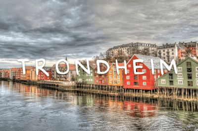
Trondheim is a city in the Norwegian county of Trøndelag. With 198 219 inhabitants, it is the third largest city in Norway. Trondheim is located on the Trondheimfjord. The Hurtigruten ferry service docks in the city's harbour.
https://allesovernoorwegen.nl/...
In ancient times, Trondheim was the capital of Norway and the center of the Norwegian Vikings. The city is located in the county of Trøndelag on the Trondheimfjord and has almost 195,000 inhabitants. With this number of inhabitants, Trondheim is the third largest city in Norway and also the largest city in the middle of Norway!
Although it is often not a city that immediately rings a bell with everyone, it is definitely worth a visit during a tour of Norway. Trondheim is surrounded by impressive nature. It is also a real student city and has numerous cozy restaurants, cafes and museums. In short, a versatile destination with plenty to do!
TRONDHEIM E6 - OPPDAL road no:70 - SUNNDALSRORA road no: 62 then at NESSET to road no: 660 to road no: 64 - ANDALSNES

TRONDHEIM E6 - OPPDAL road no:70 - SUNNDALSRORA road no: 62 then at NESSET to road no: 660 to road no: 64 - ANDALSNES
Orkanger is a place in Orkland Municipality, Norway, in Trøndelag County. It is the capital of the municipality and has more than 8,000 inhabitants. Orkanger has an area of 6.25 km². In 2014, the place received city status. Between 1920 and 1963 Orkanger was an independent municipality.
Orkanger is a place in Orkland Municipality, Norway, in Trøndelag County. It is the capital of the municipality and has more than 8,000 inhabitants. Orkanger has an area of 6.25 km². In 2014, the place received city status. Between 1920 and 1963 Orkanger was an independent municipality.
Road no: 65 then E39 then road no: 70 (direction KRISTIANSUND
Ferry: Halsa - Kanestraum Fjord1 AS
See app for departure times costs about € 13,-
Road no: 65 then E39 then road no: 70 (direction KRISTIANSUND
Ferry: Halsa - Kanestraum Fjord1 AS
See app for departure times costs about € 13,-
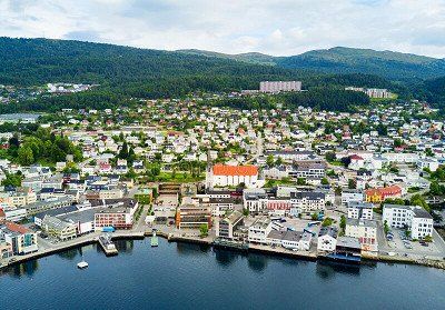
Kristiansund is a town and municipality in Møre og Romsdal county, Norway. The municipality, with 24,442 inhabitants, consists of the city of Kristiansund and the island of Frei. The town of Kristiansund is located on the coast of Nordmøre and consists of several islands; Kirkelandet, Nordlandet and Innlandet.
Walking in the center of Kristiansund
Kristiansund is a small town but offers a variety of cafes, shops and city facilities. In addition, there are various hiking options in or near the city. "The Ocean Path" is only 20 minutes away. on foot from the port.
The terrain is partly hilly, but there are bridges and steps on some parts of the trail to ensure good accessibility. There are fantastic views of the open sea and during the tour you will also come across historical sites such as bunkers from the Second World War. There are information boards about the special fauna in the area.
The tour is suitable for those with some hiking experience and is marked as moderately challenging. It has a total length of 4 km, consisting of part natural path and part dirt road.
Road no: 64
Ferry: Åfarnes - Sølsnes Fjord1 AS
See app for departure times € 10,-

The Atlantic Road is part of Fylkesvei 64 in Møre og Romsdal county in western Norway. The road connects the islands from Averøy to Vevang and Eide to the mainland to Kristiansund and Molde. Work began on August 1, 1983, until it opened on July 7, 1989.
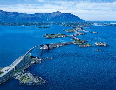
The Atlantic Road is part of Fylkesvei 64 in Møre og Romsdal county in western Norway. The road connects the islands from Averøy to Vevang and Eide to the mainland to Kristiansund and Molde. Work began on August 1, 1983, until it opened on July 7, 1989.
Molde is the capital of the Norwegian province of Møre og Romsdal. The municipality had a population of 26,822 in January 2017. It is also the seat of the Bishop of Møre. In 2020 Molde was expanded with the former municipalities of Midsund and Nesset.
The city of roses, that is how the fjord city of Molde is also called. This Norwegian city is particularly popular with travelers and tourists who enjoy panoramic views. Molde is located on a large lake and near the ocean, on a slope at the Romsdalsfjord. Molde owes the nickname city of roses to its old houses, beautiful gardens and parks. You can find Molde in the Western fjord area of Norway, in the province of More og Romsdal. But what is there to do in this city and its surroundings? We have listed the to-do's for you for an unforgettable experience in Molde.
View over no less than 222 (!) mountain peaks from Varden
Around Molde you may find one of the most beautiful areas in Norway. This is due to the many mountains and beautifully situated fjords. Climb the Varden viewpoint, located about 400 meters above sea level. From this point you have a beautiful view over the city of Molde, the fjord and the various islands and mountains. On a clear day with good weather you seem to be able to see all 222 (!) mountain peaks with snow in the vicinity.
The walk to the Varden viewpoint is easy to do, both for novice and experienced hikers. You have beautiful views along the way! For the less fanatics among us it is also possible to drive up Mount Varden by car. And you can rent mountain bikes in the area and climb Varden by bike, highly recommended!
Åndalsnes is a small town in Rauma Municipality in Møre og Romsdal County. Åndalsnes has approximately 3,000 inhabitants and is located at the mouth of the Rauma River that flows through the valley of Romsdal. The place can be reached via the railway line Raumabanen to Åndalsnes.
In addition to majestic mountains towering over deep valleys and verdant rivers, Åndalsnes is also home to gems such as Trollveggen, the Romsdalseggen ridge and the Geiranger-Trollstigen Norwegian Scenic Route.
The town of Åndalsnes in the northern part of Fjord Norway is known for its high mountains and long mountaineering tradition. That is why it is often referred to as the Alpine village by the fjord. The region has many mountains suitable for beginners, but there are also more challenging routes for experienced hikers and climbers. In winter, swap your hiking boots for skis!
For a different view of the landscape, you can walk along the via ferrata of Romsdalsstigen. Or walk along a route that was partly built by Nepalese Sherpas, towards the Rampestreken lookout point.
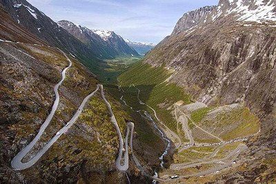
Experience the Trollstigen mountain road, one of the most visited attractions in Norway, at the UNESCO-protected Geirangerfjord.
The Trollstigen National Tourist Route is a 106 kilometer road through western Norway. Here, nature is at its best, with breathtaking views over mountain ridges, waterfalls, deep fjords and green valleys.
With a gradient of 9%, the Trollstigen mountain road consists of 11 hairpin bends. High mountains surround the road. The mountains all have stately names such as Kongen ('the King'), Dronningen ('the Queen') and Bishop ('the Bishop').
Trollstigen has been a magnet for tourists since the road opened in 1936. It is now possible, thanks to the skills of engineers and road builders, to drive up the steep mountain wall of Trollstigfoten to Stigerøra.
Ørnevegen (“the Eagle Road”) is the name of the steepest part of the road from Geiranger to Eidsdal on the highway Fv63. At Ørnesvingen you have a beautiful panoramic view of Geiranger; the waterfall 'De syv søstrene' (Seven Sisters), the mountain farm Knivsflå, and the most famous fjord in the world – Geirangerfjorden, which is also a UNESCO World Heritage Site.
Distance is not correct due to mountain pass route is shorter.
Distance is not correct due to mountain pass route is shorter.
Ferry to GUDVANGEN
crossing: Stranda-Liabygda
https://www.fjord1.no/Ruteover...
Zia app for departure times € 9,-
Ferry to GUDVANGEN
crossing: Stranda-Liabygda
https://www.fjord1.no/Ruteover...
Zia app for departure times € 9,-
Gudvangen is a village in Aurland Municipality in Sogn og Fjordane County in Norway. It is located by the Nærøyfjord, a tributary of the Sognefjord, and is a popular holiday destination. Close by is Stalheim. There is a ferry connection between Gudvangen - Kaupanger to Lærdal.
Kjelfossen Waterfall
From the quay in the center and from the main road you can see one of the highest waterfalls in Norway. With a height of 755 meters, the Kjelfossen is even one of the top twenty highest waterfalls in the world. In the months of June and July, this waterfall is at its most powerful, because of the large amount of melt water from the mountains. If you visit it at the end of the day, you will see how the waterfall colors beautifully in the setting sun. From the top of the mountain Stalheimskleiva the view of the Kjelfossen waterfall is also very good, although from a distance. In addition to a view of this waterfall, you can also see the Stalheimsfossen and Sivlefossen waterfalls.
Kjelfossen Waterfall, Gudvangen
Viking village Njardarheimr
On the outskirts of Gudvangen is the lively Viking village of Njardarheimr. The village of Gudvangen was even bigger in the time of the Vikings than it is today. Become a Viking and participate in the authentic activities in the village. The Viking Experience is a guided tour through the village. Hear the history stories about the Vikings and learn about their travels, boats and life.
Viking village Njardarheimr, Gudvangen
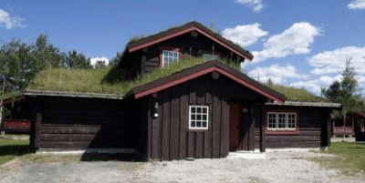
(equipped with SERVICE PLACE CAMPER)
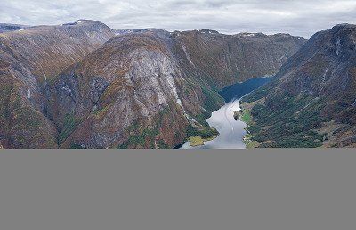
Næroyfjord
Another highlight is a visit to the Nærøyfjord. It is not for nothing that it is on the UNESCO World Heritage List, because it is the narrowest fjord in the world. At its narrowest point, this fjord is only 250 meters wide. A fun way to see this fjord is to take a sightseeing cruise from Gudvangen, which takes you between the spectacular mountains. You have a view of waterfalls that flow along the high and snow-capped mountain peaks. You also have a view of colorful villages that lie on the banks, hidden among the greenery. A boat trip takes about two to four hours.
Nærøyfjord, Gudvangen
kayaking
Experience the fairytale fjord landscape from a kayak and sail the waters of Nærøyfjord. A special experience guaranteed. Paddle past the beautiful waterfalls, small settlements and farms. You will reach places that can only be reached by kayak. You cannot rent a single kayak unless you are very experienced, but a double kayak for two is possible. Of course you can also go on an excursion accompanied by a guide.
Gudvangen is a village in Aurland Municipality in Sogn og Fjordane County in Norway. It is located by the Nærøyfjord, a tributary of the Sognefjord, and is a popular holiday destination. Close by is Stalheim. There is a ferry connection between Gudvangen - Kaupanger to Lærdal.
Kjelfossen Waterfall
From the quay in the center and from the main road you can see one of the highest waterfalls in Norway. With a height of 755 meters, the Kjelfossen is even one of the top twenty highest waterfalls in the world. In the months of June and July, this waterfall is at its most powerful, because of the large amount of melt water from the mountains. If you visit it at the end of the day, you will see how the waterfall colors beautifully in the setting sun. From the top of the mountain Stalheimskleiva the view of the Kjelfossen waterfall is also very good, although from a distance. In addition to a view of this waterfall, you can also see the Stalheimsfossen and Sivlefossen waterfalls.
Kjelfossen Waterfall, Gudvangen
Viking village Njardarheimr
On the outskirts of Gudvangen is the lively Viking village of Njardarheimr. The village of Gudvangen was even bigger in the time of the Vikings than it is today. Become a Viking and participate in the authentic activities in the village. The Viking Experience is a guided tour through the village. Hear the history stories about the Vikings and learn about their travels, boats and life.
Viking village Njardarheimr, Gudvangen
(equipped with SERVICE PLACE CAMPER)
Næroyfjord
Another highlight is a visit to the Nærøyfjord. It is not for nothing that it is on the UNESCO World Heritage List, because it is the narrowest fjord in the world. At its narrowest point, this fjord is only 250 meters wide. A fun way to see this fjord is to take a sightseeing cruise from Gudvangen, which takes you between the spectacular mountains. You have a view of waterfalls that flow along the high and snow-capped mountain peaks. You also have a view of colorful villages that lie on the banks, hidden among the greenery. A boat trip takes about two to four hours.
Nærøyfjord, Gudvangen
kayaking
Experience the fairytale fjord landscape from a kayak and sail the waters of Nærøyfjord. A special experience guaranteed. Paddle past the beautiful waterfalls, small settlements and farms. You will reach places that can only be reached by kayak. You cannot rent a single kayak unless you are very experienced, but a double kayak for two is possible. Of course you can also go on an excursion accompanied by a guide.
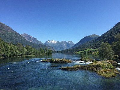
from ferry road nr 60 and then the 15 to STRYN
Stryn is a municipality and ski resort located on the Nordfjord in the Norwegian county of Vestland. The municipality had 7,218 inhabitants in January 2017. The municipality consists of the main town of Stryn and the villages of Loen, Olden, Innvik, Utvik, Nordsida and Markane on both sides of the fjord.
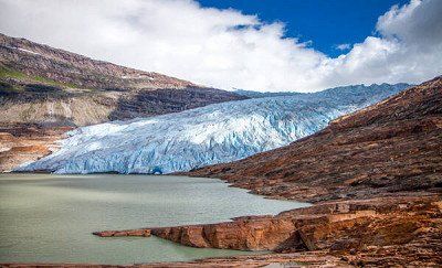
Briksdal Glacier (Briksdalbreen), Stryn
Nestled between thundering waterfalls and high cliffs along a small glacial lake, Briksdal Glacier (Briksdalbreen) represents an easily accessible arm of continental Europe's largest pancake glacier. Explore the lush valley on foot, taking the trails leading from the local mountain refuge and following streams of melting ice that flow to the sea. Take a "troll buggy" trip to the glacier if ice conditions and weather permit. Otherwise, opt for a guided glacier safari in a rafting boat on the lake. Tourist-friendly facilities include a restaurant and the largest gift shop in the area. Beware of roadblocks - glacier movement and the threat of avalanches can make roads dangerous. Use our Stryn trip planner to visit Briksdal Glacier (Briksdalbreen) on your trip to Strynen, and learn what else travelers and our writers recommend seeing nearby.
Stryn is a municipality and ski resort located on the Nordfjord in the Norwegian county of Vestland. The municipality had 7,218 inhabitants in January 2017. The municipality consists of the main town of Stryn and the villages of Loen, Olden, Innvik, Utvik, Nordsida and Markane on both sides of the fjord.
Briksdal Glacier (Briksdalbreen), Stryn
Nestled between thundering waterfalls and high cliffs along a small glacial lake, Briksdal Glacier (Briksdalbreen) represents an easily accessible arm of continental Europe's largest pancake glacier. Explore the lush valley on foot, taking the trails leading from the local mountain refuge and following streams of melting ice that flow to the sea. Take a "troll buggy" trip to the glacier if ice conditions and weather permit. Otherwise, opt for a guided glacier safari in a rafting boat on the lake. Tourist-friendly facilities include a restaurant and the largest gift shop in the area. Beware of roadblocks - glacier movement and the threat of avalanches can make roads dangerous. Use our Stryn trip planner to visit Briksdal Glacier (Briksdalbreen) on your trip to Strynen, and learn what else travelers and our writers recommend seeing nearby.
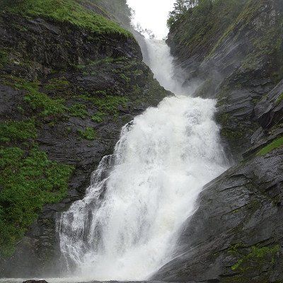
Huldefossen is a waterfall in the basin of the river Gaular and located near Mo, part of the municipality of Sunnfjord in the Norwegian county of Vestland. The Huldefossen is sometimes also called the Huldrefossen and is located in the river after which the waterfall is named, the Hulda.
Huldefossen is located in Mo, off the E39, about 10 km from Førde. There are signs to the parking lot. It is about 500 meters walk over a wooden bridge and along the river. The waterfall has a fall of approximately 90 meters in length and is one of the most photographed waterfalls in Fjord Norway.
Huldefossen, 6819 Førde, Norway (address)
Road nr : Fv13 to BALESTRAND narrow roads and hairpin bends. Beautiful route
Road nr : Fv13 to BALESTRAND narrow roads and hairpin bends. Beautiful route
Balestrand is a former municipality in the Norwegian county of Sogn og Fjordane, on the Sognefjord. The municipality had 1,288 inhabitants in January 2017. The Esefjord empties into the Sognefjord on the east side of Balestrand. The main sources of income were agriculture and tourism.
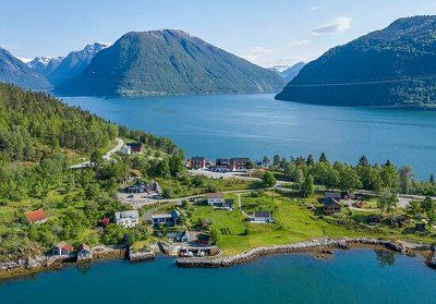
Balestrand is a former municipality in the Norwegian county of Sogn og Fjordane, on the Sognefjord. The municipality had 1,288 inhabitants in January 2017. The Esefjord empties into the Sognefjord on the east side of Balestrand. The main sources of income were agriculture and tourism.
Dragsvik - Vangsness ferry crossing
https://www.rome2rio.com/s/Van...
https://autopassferje.no/prise...
€60
Dragsvik - Vangsness ferry crossing
https://www.rome2rio.com/s/Van...
https://autopassferje.no/prise...
€60
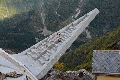
Vangsnes is a village of Vik Municipality in Vestland County in Norway. In the village stands the 22 meter tall statue Fridtjof den frøkne. It represents the main character of the Old Norse Frithjofssaga.
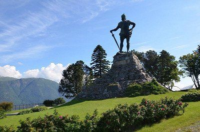
Vangsnes is a village of Vik Municipality in Vestland County in Norway. In the village stands the 22 meter tall statue Fridtjof den frøkne. It represents the main character of the Old Norse Frithjofssaga.
Vossevangen is a place in the municipality of Voss herad in the Norwegian province of Vestland. Vossevangen has 5674 inhabitants and has an area of 4.51 km². Voss van de Bergensbanen is located in Vossevangen.
Are you ready for action-packed adventures, the extreme environment and Norwegian culinary specialties in Voss, the adrenaline capital of Europe?
You are most welcome in the village of Voss with its snow-capped mountains, green valleys, wild rivers, rugged waterfalls and calm lakes. About 15,000 people live there and Voss is strategically located between Bergen, the Sognefjord and the Hardangerfjord.
Are you an adrenaline junkie? Then Voss is the place to be! Take on the rapids of one of the best rivers in Europe for rafting, jump out of a plane (with a parachute of course) or soar above the landscape with a paraglider.
The two ski areas, Myrkdalen Fjellandsby and Voss Resort, turn Voss into one of Fjord Norway's top ski destinations in winter. The rest of the year, the varied landscape is ideal for hiking and cycling, or how about mountain climbing or kayaking? There is always something to experience, also for you!
Or you can hop on the Voss gondola that takes you from the train station to the mountains in nine minutes!
On top of Hangurstoppen mountain, 820 meters above sea level, is the largest restaurant in Voss.
The region carries 'Tasty food!' literally and figuratively high on the agenda. Even Gordon Ramsay has visited the region to sample the traditional regional dish, smalahove (sheep's head). Farm Smalahovetunet prepares this specialty especially for you. There is also cured meat, salted and dried mutton ribs and porridge with sour cream on the menu.
This village also hosts a number of well-known events, such as Vossa Jazz and Ekstremsportveko, the largest extreme sports festival in the world!
Detailed travel information can be found on the official Voss website.
Kinsarvik is a place in the Norwegian municipality of Ullensvang, province of Vestland. Kinsarvik has 453 inhabitants and has an area of 0.71 km². Kinsarvik was an independent municipality in Hordaland between 1913 and 1964. Kinsarvik is located on the Sørfjord, a tributary of the Hardangerfjord.
Kinsarvik is a place in the Norwegian municipality of Ullensvang, province of Vestland. Kinsarvik has 453 inhabitants and has an area of 0.71 km². Kinsarvik was an independent municipality in Hordaland between 1913 and 1964. Kinsarvik is located on the Sørfjord, a tributary of the Hardangerfjord.
Odda is a former municipality in the Norwegian province of Hordaland with 7025 inhabitants. Odda was located on the Sørfjord, a tributary of the Hardangerfjord. On January 1, 2020, Odda was incorporated together with the municipality of Jondal into the municipality of Ullensvang which was incorporated into the province of Vestland formed on the same day.
Odda is a former municipality in the Norwegian province of Hordaland with 7025 inhabitants. Odda was located on the Sørfjord, a tributary of the Hardangerfjord. On January 1, 2020, Odda was incorporated together with the municipality of Jondal into the municipality of Ullensvang which was incorporated into the province of Vestland formed on the same day.
Haukeligrend is a place belonging to the municipality of Vinje in the county of Vestfold og Telemark in southern Norway. It is located along the E134 at the point where Riksvei 9 ends.
Haukeligrend is a place belonging to the municipality of Vinje in the county of Vestfold og Telemark in southern Norway. It is located along the E134 at the point where Riksvei 9 ends.
Route
Show newest first- 51.6014 5.3122
- 51° 36' 5.2" N 5° 18' 43.8" E
- 51.8875 5.194
- 51° 53' 14.9" N 5° 11' 38.4" E
- 54.7737 9.3939
- 54° 46' 25.4" N 9° 23' 38.1" E
- 57.4568 9.9958
- 57° 27' 24.4" N 9° 59' 44.7" E
- 57.5553 9.9332
- 57° 33' 19.2" N 9° 55' 59.6" E
- 57.587 9.9668
- 57° 35' 13" N 9° 58' 0.6" E
Oversteek duurt 2 uur en 15 minuten.
- 58.1599 8.0182
- 58° 9' 35.7" N 8° 1' 5.5" E
- 58.3617 8.6613
- 58° 21' 42.2" N 8° 39' 40.7" E
- 58.617 8.3941
- 58° 37' 1.2" N 8° 23' 38.7" E
Verder over de weg 41 naar AMLI
Over de E134 naar VINJE
Via wegnr: 37 naar RJUKAN
Links af naar het noorden volg het Tessungdalen naar de hoofdweg naar GEILO
Richting het oosten wegnr: 7 naar GOL
dan naar noordenweg nr: 51 tot LEIRA
- 60.9697 9.2911
- 60° 58' 10.9" N 9° 17' 28" E
Vanuit hier een klein weggetje naar het noord oosten tot GAUSDAL SEGELSTAD- BRU
- 61.2282 10.2226
- 61° 13' 41.5" N 10° 13' 21.2" E
- 60.8487 14.5409
- 60° 50' 55.5" N 14° 32' 27.4" E
Van hieruit wegnr: 255 richting noord west tot VINSTRA vervolgens rijden naar het zuidoosten tot aan het noorden van RINGEBU
Dan via wegnr 27 die zich splitst naar FOLLDAL.
Nationaal park RONDANE wegnr: 29 naar het oosten tot ALFDAL
Dan via de E3 naar het noorden richting TYNSET
Rechts af wegnr: 30 naar ROROS
Nu richting het oosten richting BREKKEN
(naar Myrmoen) dan naar het noorden op wegmr: 705 van SELBU tot ST JORDAL
- 66.2092 13.8048
- 66° 12' 33" N 13° 48' 17.2" E
Over de E6 naar MO I RANA
https://autopassferje.no/priser/
Torghatten Nord AS (torghatten-nord.no)
http://www.torghatten-nord.no
https://autopassferje.no/prise...
vanuit hier naar de LOFOTEN
Mooie rustplaats
- 68.4385 17.4273
- 68° 26' 18.6" N 17° 25' 38.1" E
Gaan we hier een doorsteek maken naar zuiden.
Vanuit NARVIK naar E10 over Zweden?
Zweden E10 Sakajärvi naar de E45
neem de E14 naar het westen tot STJORDAL - TRONDHEIM - ORKANGER wegnr 71 of 65 tot KRISTIANSUND
TRONDHEIM E6 - OPPDAL wegnr:70 - SUNNDALSRORA wegnr: 62 dan bij NESSET naar wegnr: 660 naar wegnr: 64 - ANDALSNES
Wegnr: 65 dan E39 dan wegnr: 70 (richting KRISTIANSUND
Veerboot: Halsa - Kanestraum Fjord1 AS
Zie app voor vertrektijden kosten ca € 13,-
Wegnr: 64
Veerboot: Åfarnes - Sølsnes Fjord1 AS
Zie app voor vertrektijden € 10,-
- 63.001 7.2916
- 63° 0' 3.6" N 7° 17' 29.9" E
- 62.4549 7.666
- 62° 27' 17.7" N 7° 39' 57.5" E
Afstand klopt niet ivm bergpas route is korter.
Veerboot naar GUDVANGEN
oversteek: Stranda-Liabygda
https://www.fjord1.no/Ruteover...
Zia app voor vertrektijden € 9,-
vanaf veerboot wegnr 60 en dan de 15 naar STRYN
E39 naar MOSKOG
- 61.411 6.1268
- 61° 24' 39.4" N 6° 7' 36.5" E
Wegnr : Fv13 tot BALESTRAND smalle wegen en haarspeld bochten. Mooie route
Overtocht met veerboot Dragsvik - Vangsness
https://www.rome2rio.com/s/Van...
https://autopassferje.no/prise...
€ 60,-
- 60.6296 6.4222
- 60° 37' 46.4" N 6° 25' 19.7" E
- 59.5604 7.3567
- 59° 33' 37.6" N 7° 21' 24.1" E
- 58.582 7.7943
- 58° 34' 55" N 7° 47' 39.4" E
- 58.3447 8.5949
- 58° 20' 40.9" N 8° 35' 41.5" E
- 57.587 9.9668
- 57° 35' 13" N 9° 58' 0.6" E
- 51.6014 5.3122
- 51° 36' 5.2" N 5° 18' 43.8" E
Travelogue
Pick up package for Norway.
Pick up package for Norway.
motorhome contact 62605
Great, free!, place to stay overnight on your way to Denmark. Groceries (large supermarket) and breakfast (at the bakery) across the street in the shopping center. The toilets in the shopping center can be used during opening hours. at night it is quiet and you are back on the highway in a few minutes.
https://www.citti-park-flensbu...
motorhome contact 62605
Great, free!, place to stay overnight on your way to Denmark. Groceries (large supermarket) and breakfast (at the bakery) across the street in the shopping center. The toilets in the shopping center can be used during opening hours. at night it is quiet and you are back on the highway in a few minutes.
https://www.citti-park-flensbu...
Site code: 9923
Bredkærvej 89
9800, Hjorring, Denmark
57° 26' 26" N
10° 3' 26" E
57.44059
10.05735
Site code: 9923
Bredkærvej 89
9800, Hjorring, Denmark
57° 26' 26" N
10° 3' 26" E
57.44059
10.05735
Alternative 48625
Tornby Strand Camping Hirtshals, Denmark
Alternative 48625
Tornby Strand Camping Hirtshals, Denmark
Crossing takes 2 hours and 15 minutes.
Crossing takes 2 hours and 15 minutes.
Deliver package to family.
Deliver package to family.
Arendal is a town in the Arendal municipality in the Norwegian county of Agder in southern Norway. In the center is the Tyholmen area with wooden houses from around 1600. The harbor is called Pollen, where you can find the fish market, cafes and restaurants.
Arendal is a town in the Arendal municipality in the Norwegian county of Agder in southern Norway. In the center is the Tyholmen area with wooden houses from around 1600. The harbor is called Pollen, where you can find the fish market, cafes and restaurants.
Åmli is a village and municipality in fylke Agder in Norway. It is a typical rural community that largely consists of forest. In January 2017, Åmli had 1,856 inhabitants. The board is located in the village of Åmli, where about 600 people live.
Åmli is a village and municipality in fylke Agder in Norway. It is a typical rural community that largely consists of forest. In January 2017, Åmli had 1,856 inhabitants. The board is located in the village of Åmli, where about 600 people live.
Treungen is a village in and the administrative center of Nissedal Municipality, Telemark County in Norway. Located just east of the village of Tveitsund, it is part of the urban area of the same name, which has a population of 361 as of January 1, 2009.
Treungen is a village in and the administrative center of Nissedal Municipality, Telemark County in Norway. Located just east of the village of Tveitsund, it is part of the urban area of the same name, which has a population of 361 as of January 1, 2009.
Brunkeberg is a village in Kviteseid Municipality in Vestfold og Telemark County, Norway. The European route E134 which runs from Drammen to Haugesund passes through the village. The Brunkebergkerk is a white cruciform church from 1790
Brunkeberg is a village in Kviteseid Municipality in Vestfold og Telemark County, Norway. The European route E134 which runs from Drammen to Haugesund passes through the village. The Brunkebergkerk is a white cruciform church from 1790
Vinje is a municipality in Vestfold og Telemark county in southern Norway. The municipality had 3,726 inhabitants in January 2017.
Vinje is located in the Hjart valley, southeast of the plateau Hardangervidda. It borders Nore og Uvdal to the north, Tinn and Seljord to the east, Tokke and Bykle to the south, and Suldal, Odda and Ullensvang to the west.
Rjukan is a place in the municipality of Tinn in the county of Vestfold og Telemark in Norway. It is one of the few cities in Norway designed on the drawing board.
THE VILLAGE OF RJUKAN IN TELEMARK, SOUTH NORWAY
The town of Rjukan is located near the Hardanger National Park and is known for the famous Gaustatoppen (1833 meters) and its important role in the Second World War. Museums It with exhibitions about the industrial development of Norway and Rjukan in particular. Very special is the exhibition about Rjukan in the Second World War, especially about the resistance fighters who sabotaged the German plans to develop an atomic bomb in Vemork. The Tinn Museum, an open-air museum with buildings from the 16th to the 20th century. The mountain farms are still working as before. The Tinn Håndverksenter is a combination of art and home crafts exhibitions. Cable car Kitelsen. Very special is the Krossobanen, the first funicular in Northern Europe, built in 1928 and built for the population so that they could see the sun in winter. The cable car takes you to an altitude of 866 meters. At the top you have a beautiful view. www.krossobanen.no(link is external)
Nature
First of all, the Gaustatoppen with a height of 1883 meters above sea level. In clear weather you can see a sixth part of Norway! You can also take a train up to 860 meters up the mountain. The Hardangervidda is a vast mountain plateau, an untouched wilderness. The largest herd of wild reindeer in Northern Europe lives here. A beautiful area for the experienced hiker. The Rjukan Waterfall is 104 meters high and definitely worth a visit.
Left to the north follow the Tessungdalen to the main road to GEILO
Geilo is a town in the county of Viken in southern Norway with about 2300 inhabitants. Geilo belongs to the municipality of Hol. It is located on the lake Ustedalsfjorden. Geilo is best known as a ski area, with 39 slopes, 20 ski lifts and about 220 km of cross-country trails.
Geilo is a town in the county of Viken in southern Norway with about 2300 inhabitants. Geilo belongs to the municipality of Hol. It is located on the lake Ustedalsfjorden. Geilo is best known as a ski area, with 39 slopes, 20 ski lifts and about 220 km of cross-country trails.
Gol is a municipality in the Norwegian province of Viken. The municipality had 4612 inhabitants in January 2017. Gol borders Ål, Hemsedal and Nes and Nord-Aurdal and Sør-Aurdal in Oppland county.
Located in the medieval park Gordarike, the Gol Stave Church is a faithful copy of the Gol Stave Church built in the 1200s. The example was built in the 1980s and consecrated by the Bishop of Tunsberg in 1994. summer evening on Wednesdays there is a devotional and sometimes musical performance. The church is often used for weddings. The woodwork in the church is still bright and it's easy to see all the beautiful carvings and details. Visit the church and be humbled by the mood with which you are greeted. Inside you can listen to the beautiful Gregorian choral music (CD). You can study the stave church architecture in the Viking Hall next to the exhibition. Same opening hours/entrance ticket as for the Gordarike Family Park. Gol Stave Church (Gol stavkirke) is a stave church originally from Gol, Hallingdal, Norway. It is now located in the Norwegian Museum of Cultural History in Bygdøy in Oslo, Norway. When the city built a new church around 1880, it was decided to demolish the old stave church. It was saved from destruction by the Society for the Preservation of Ancient Norwegian Monuments, who bought the materials to rebuild the church elsewhere. It was purchased by King Oscar II, who financed its relocation and restoration as the central building of his private open-air museum near Oslo. The restoration, overseen by architect Waldemar Hansteen, was completed in 1885. In 1907 this early open-air museum, the world's first, was merged with the Norwegian Museum of Cultural History, which now manages the stave church, still nominally owned by the reigning monarch . The church is dendrochronologically dated to 1212. In the 1980s,
Leira is a place in the Norwegian municipality of Nord-Aurdal, province of Innlandet. Leira has 788 inhabitants (2007) and has an area of 1.22 km².
Leira is a place in the Norwegian municipality of Nord-Aurdal, province of Innlandet. Leira has 788 inhabitants (2007) and has an area of 1.22 km².
From here a small road to the north east to GAUSDAL SEGELSTAD- BRU
From here a small road to the north east to GAUSDAL SEGELSTAD- BRU
Segalstad bru is a place in Gausdal Municipality, Innlandet County, Norway. Segalstad bru has 862 inhabitants and has an area of 1.17 km². It is the main town of the municipality.
Segalstad bru is a place in Gausdal Municipality, Innlandet County, Norway. Segalstad bru has 862 inhabitants and has an area of 1.17 km². It is the main town of the municipality.
From here road nr: 255 north west to VINSTRA then south east to the north of RINGEBU
From here road nr: 255 north west to VINSTRA then south east to the north of RINGEBU
Ringebu is a municipality and ski resort in Gudbrandsdal in the Norwegian county of Innlandet. Ringebu borders Sør-Fron to the northwest, Gausdal to the southwest, Øyer to the south and Stor-Elvdal in Hedmark County to the east. Ringebu is located at 182 meters above sea level.
About Ringebu Stave Church Built in about 1220, this distinctive and much-photographed stave church is one of only 28 remaining in Norway. Once common, more than 1000 scattered across the countryside, with their unique style of architecture and construction, and they are symbolic of old Norway. Christianity was introduced to Norway around 1000 AD and about a thousand stave churches were built in the years that followed.
The original church was renovated in the 17th century when the distinctive red tower was added, and while the interior was painted white at one point, the original color has since been restored.
Ringebu Stave Church and the surrounding cemetery, amid hills and farmland, are strikingly beautiful, with immaculate grounds. A thoughtful touch is provided by the watering cans left at each tap for the use of people tending the graves, and these are clearly put to good use. Nearly every grave on the property has been planted with a small garden, and all are still lovingly maintained, making this a truly beautiful and distinctive resting place.
Traditionally built without the use of a single nail, they are composed of wood that has been skilfully swallowed, with vertical posts and wall planks resting on ground beams. Again, the use of tar to preserve the wood resulted in the loss and destruction by fire of many stave churches. Post holes have also been found here in Ringebu, indicating the presence of an even older church, with a cache of over 900 medieval coins found beneath the church, which have contributed to dating its construction.
The Rectory of Ringebu Built in 1743, the Rectory of Ringebu occupies a beautiful location north of the Ringebu Stave Church and was fully in use until 1991. Today, this monumental and restored rectory is a historic experience in itself. There are 5 buildings in the yard; the main building, two warehouses, staff quarters and an outbuilding.
Please note that the church may be closed in connection with church events, such as church services, weddings, funerals and the like
Then via road nr 27 which splits to FOLLDAL.
Then via road nr 27 which splits to FOLLDAL.
Folldal is a municipality in the Norwegian county of Innlandet. The municipality had 1,577 inhabitants in January 2017. Folldal borders Oppdal and Tynset in the north, Alvdal in the east, Stor-Elvdal, Sør-Fron and Sel in the south and Dovre in the west.
Rondane National Tourist Route is one of 18 selected road sections in Norway. It runs from Muen and Sollia Church to Folldal.
The road follows the east side of the Rondane National Park and switches between cultural landscape and a majestic mountain range. The drive along the Blue Mountains is a journey of discovery in nature, culture and geology. At Atnasjøen you can experience the mighty view from the Sohlbergplassen. Take a walk to Fallfossen and the old Grimsa Bridge or take a break in the Strømbu Rest Area. The Rest Area is the starting point for walks from the east and for mountain walks in Alvdal Vestfjell and Breisjøseter Tourist Cabin. In Folldal you can visit the old Mining Company and enjoy the panorama from the viewpoint.
FROM THE SOUTH
Gateway Ringebu: If you drove from Oslo on the E6 highway, the Rondane National Tourist Route can start from Ringebu. From there you can drive over the mountains, Venabygdsfjellet, and down where you can choose to head towards Hjerkinn in the west and Alvdal in the east.
Gateway Atna: If you are on route no. 3 from Elverum you can start from Atna and drive northwest. Here too you can choose whether you drive towards Hjerkinn or Alvdal.
FROM THE NORTH
Hjerkinn Port: Departing from Dovrefjell and west, Hjerkinn is an excellent gateway for your journey along the Rondanevegen. From the mountain plateau on Dovrefjell, the route leads to Folldal. After a few kilometers you can already see the contours of the Rondane mountains on the right.
Gateway Alvdal: If you're coming from the northeast and Røros or maybe from Sweden, start from Alvdal. While driving you will see the beginning of the Rondane mountains to the east and from Folldal you will drive through the characteristic landscape for which the Rondane mountains are known.
RONDANE National Park road no: 29 east to ALFDAL
RONDANE National Park road no: 29 east to ALFDAL
Alvdal is a village in Alvdal Municipality, Innlandet County, Norway. Alvdal has 667 inhabitants and has an area of 1.63 km². It is the seat of the municipal council. The village is located where the River Folla flows into the Glomma. The village has a station at Rørosbanen.
The largest gorge in Northern Europe, formed during the last ice age, about 10,000 years ago. You can experience the Jutulhogget Gorge on foot by descending the steep trail, or you can enjoy the view from the edge.
Then via the E3 to the north towards TYNSET
Then via the E3 to the north towards TYNSET
Tynset is a municipality in the Norwegian county of Innlandet. The municipality had 5584 inhabitants in January 2017. The municipal council is located in the town of the same name.
Tynset Rom & Camping is idyllically located next to the river "Glomma", directly over the bridge and centrally located in the center of Tynset. Here you will find accommodation in rooms, apartments and cabins, ranging from simple to luxurious. There is also a large site with electricity that can accommodate caravans, motorhomes and tents.
Tynset Rom & Camping is idyllically located next to the river "Glomma", directly over the bridge and centrally located in the center of Tynset. Here you will find accommodation in rooms, apartments and cabins, ranging from simple to luxurious. There is also a large site with electricity that can accommodate caravans, motorhomes and tents.
Røros is a town and municipality in the Norwegian county of Trøndelag. The municipality had 5623 inhabitants in January 2017. Røros is the highest town in Norway, at 628 meters above sea level. It has a station on Rørosbanen to Trondheim. Just west is the airport.
Røros is tucked away in inland Norway, not far from the border with Sweden. It is not an undiscovered village, as UNESCO listed it as a World Heritage Site in the 1980s, but arriving in Røros feels like walking into a fairytale, as if time has stood still here. Colorful wooden houses with white snowy roofs. Horse and carriage pass with ringing bells. Everywhere you look it is white and every house looks like you want to live there. A village from a winter fairytale.
It's actually quite special that people live in Røros, because it can get incredibly cold here. The record is about 50 degrees below zero, but on average it is minus 30 here in winter. The reason that Røros is still inhabited has to do with the history of the village. Long ago copper was discovered in the ground here and that turned out to be the jackpot. Røros and the surrounding area are now on the UNESCO World Heritage List for the mining history of this area.
To get there, you have to make a long journey, because it also takes about three hours by road from Trondheim (the nearest large city), but the nice thing is that the journey itself is a special experience in itself.
The figurehead of Røros is of course the striking church that can be seen from almost anywhere in the village. It was a gift from the mine bosses to the inhabitants of the village, with exactly as many seats as there were residents at the time. Nice to see inside and out, but the real nice part of Røros is of course the small streets downtown. Behind every door there is something special: a store with warm clothing or home accessories, a coffee bar to warm up with hot chocolate or maybe you step into a Norwegian cafe. Anyone who has ever seen Pippi Longstocking's films may recognize one of the streets. Not all wooden houses in the village are inhabited, but most of the windows have a poinsettia and so there is life indoors.
The mining museum
For a long time, life in this area was completely occupied by the copper mines. In the museum, in the middle of the old town, you can learn something about this time. You can see how incredibly hard it was for the miners here, because they had to work hard under harsh conditions. It is part of the history of Røros and is well worth a visit!
Breken, is a place and former municipality in Norway. The municipality was located in what was then Sør-Trøndelag County. The municipality was founded in 1926 as a split from Røros. In 1964 the municipality was again added to Røros. The old congregation still exists as a parish of the Norwegian Church.
Breken, is a place and former municipality in Norway. The municipality was located in what was then Sør-Trøndelag County. The municipality was founded in 1926 as a split from Røros. In 1964 the municipality was again added to Røros. The old congregation still exists as a parish of the Norwegian Church.
(to Myrmoen) then north on road mr: 705 from SELBU to ST JORDAL
(to Myrmoen) then north on road mr: 705 from SELBU to ST JORDAL
Selbu is a municipality in the Norwegian county of Trøndelag. The towns of Mevangen and Trøa are part of the municipality. The municipality had 4,098 inhabitants in January 2017. Surrounding municipalities are Tydal in the south and Malvik in the north.
Selbu is a municipality in the Norwegian county of Trøndelag. The towns of Mevangen and Trøa are part of the municipality. The municipality had 4,098 inhabitants in January 2017. Surrounding municipalities are Tydal in the south and Malvik in the north.
Stjørdal is a municipality in the Norwegian county of Trøndelag. The municipality had 23,625 inhabitants in January 2017. Stjørdal's coat of arms contains a tapeworm.
The Stjørdalsfjord is an arm of the Trondheimsfjord that extends east to the mouth of the Stjørdalselva River at the head of the fjord. The Stjørdal Delta has for the most part developed into Stjørdal town, industrial areas and an airport. Fragments of the original delta habitats are more or less intact, but still attract a number of wetland species during migration, both at the estuary and along the river.
NAFCamp camping - pitches on water - mini kiosk - supermarket 300m - center 750m.
Was stationed here during its time as a Marine 1984 cold weather training.
NAFCamp camping - pitches on water - mini kiosk - supermarket 300m - center 750m.
Was stationed here during its time as a Marine 1984 cold weather training.
Bjerka is a place in Hemnes Municipality, Nordland County, Norway. Bjerka has 428 inhabitants and has an area of 0.89 km².
NAFCamp camping - pitches on water - mini kiosk - supermarket 300m - center 750m.
Bjerka is a place in Hemnes Municipality, Nordland County, Norway. Bjerka has 428 inhabitants and has an area of 0.89 km².
NAFCamp camping - pitches on water - mini kiosk - supermarket 300m - center 750m.
Mo i Rana is a town in Rana Municipality on the Ranfjord in Nordland in northern Norway. To the south is Mosjøen and to the north Fauske. It is the fourth largest city in northern Norway, with approximately 18,000 inhabitants. The city is located just south of the Arctic Circle at 66.5° N
Mo i Rana
Mo i Rana is a town in Rana Municipality on the Ranfjord in Nordland in northern Norway. The town is located north of Mosjøen and south of Fauske. It is the fourth largest city in northern Norway. The city is located just south of the Arctic Circle.
caves
Near Mo i Rana are more than 200 caves, the most famous of which are the Setergrotta and Grønli Cave. The latter is the most visited limestone cave in Norway.
Sights
In addition to a visit to the caves, a visit to the Arctic Circle Center is a good option. In addition, a visit to the Saltfjellet-Svartisen National Park with the Svartisen glacier and the Engabreen tributary is a must. For those interested, Mo i Rana is a branch of the National Library of Norway.
Mo i Rana Camping
Mo i Rana Camping is a campsite in Mo i Rana (Nordland, Norway), located a river/stream. The campsite is used by many people as a place to stay overnight on the way to the North Cape. The campsite has which are marked out and pitches without shade. It is possible to rent hikers' cabins, rooms and apartments. In the vicinity you can swim in the river/stream. It is possible to use the internet, because the campsite has one or more computers with an internet connection and there is a wifi point.
The Nordlandsbanen train route passes Mo i Rana and there is an airport, Mo i Rana Airport. Traffic and transport are done via the E6.
https://viatioga.nl/voorpret/b...
https://autopassferje.no/priser/
Torghatten Nord AS (torghatten-nord.no)
http://www.torghatten-nord.no
https://autopassferje.no/priser/
Torghatten Nord AS (torghatten-nord.no)
http://www.torghatten-nord.no
https://autopassferje.no/prise...
https://autopassferje.no/prise...
Narvik is a municipality in Nordland county in Norway that acquired city rights in 1902. The city has 18,630 inhabitants. With its location at 68° north latitude, it is the northernmost city in Europe with a railway station after Murmansk in Russia, which is slightly more northerly.
The town of Narvik is located in Northern Norway and is surrounded by majestic nature. High mountains tower over the blue Ofotfjord and are perfect for hiking and skiing. In winter, the Northern Lights dance across the sky at night, and the midnight sun makes for long, clear summer nights.
From Narvik you can hop on one of the most beautiful train journeys in the world on the Ofoten Railway. It was built by the navvies at the end of the 19th century. During the journey you can see traces of the Battle of Narvik which took place during the Second World War. You will learn more about it at the Narvik War Museum.
The Polar Park in Narvik is the northernmost zoo in the world. Admire animals such as wolves, lynx and bears, as well as reindeer, moose and arctic foxes.
Narvik is currently undergoing the process of obtaining the Sustainable Destination Certificate, a seal of approval awarded to destinations that systematically try to counteract the negative impact of tourism.
Detailed travel information can be found on Narvik's official website. https://www.visitnarvik.com/
Bjerkvik is a place in Narvik Municipality, Nordland County, Norway. Bjerkvik has 1195 inhabitants and has an area of 1.42 km². Bjervik includes hotels, supermarkets, rental car service and a comprehensive school with kindergarten, primary, secondary and gymnasium.
Bjerkvik is a place in Narvik Municipality, Nordland County, Norway. Bjerkvik has 1195 inhabitants and has an area of 1.42 km². Bjervik includes hotels, supermarkets, rental car service and a comprehensive school with kindergarten, primary, secondary and gymnasium.
The Lofoten are an archipelago off the coast of Nordland county in northern Norway. The Lofoten consists of a number of islands. The best known are: Røst Værøy Gimsøya Moskenesøya Vestvågøy Austvågøy Flakstadøya Some places on the Lofoten are Svolvær, Leknes, Vågan, Ramberg, Moskenes and Reine.
The Lofoten
The Lofoten are sometimes jokingly referred to as 'the Norwegian Maldives'. The comparison lies in the unprecedented island splendor, because the weather is different here (although the cold is not too bad, see below!). The Lofoten are located well above the Arctic Circle in the middle of the North Sea. The landscape of the island archipelago is of pristine, magical beauty; an untouched wilderness full of wild mountain ranges, deep fjords, long sandy beaches and idyllic fishing villages with typical red houses. The Lofoten is also ideal for outdoor enthusiasts: you can go hiking, kayaking, rafting, whale watching, skiing, climbing, fishing and even surfing.
The main islands of Austvågøy, Vestvågøy, Flakstadøy and Moskenesøy are separated from the mainland by the sea of Vestfjorden, but are all connected by bridges and tunnels. One of the best ways to discover the islands is via the E10, a winding road that covers all corners of the islands.
Lofoten highlights and sights
The main attraction of Lofoten is the overwhelmingly beautiful landscape. Some of the best activities include kayaking in the golden midnight sun, rafting in the Trollfjord (where you'll almost certainly spot the mighty sea eagle, seals and countless seabirds!) and of course the Northern Lights safaris. Furthermore, there are countless remote characteristic fishing villages on the Lofoten with typical red fishermen's houses on the water (some of them converted into residential accommodation!). Of course you will find some of the best fishing waters on earth.
Lofoten towns and accommodation
The largest and most important town in Lofoten is Svolvær (population 5,000), which is also where the Hurtigruten (the famous Norwegian Coastal Express boat) moors. A bit more atmospheric is nearby Kabelvåg, which, like Svolvær, is located on the main island of Austvågøy. The town of Leknes (approx. 3000 inhabitants) on the central island of Vestvågøy is considered an unofficial 'capital town', it is also the only hospital in the region.
The village of Henningsvær is spread over several small islands, which is especially popular for its special location. Another much-photographed fishing village is the more remote and very picturesque Reine on Moskenesøy, arguably the prettiest of them all. Close to Reine – on a small island between two bridges – is the equally photogenic Hamnoy, with its beautiful harbor.
Beautiful resting place
Beautiful resting place
Let's make a cut here to the south.
From NARVIK to E10 over Sweden?
Let's make a cut here to the south.
From NARVIK to E10 over Sweden?
Sweden E10 Sakajärvi to the E45
Sweden E10 Sakajärvi to the E45
Jokkmokk is a town in northern Sweden and the administrative center of the municipality of the same name. The place is located about 5 kilometers inside the Arctic Circle. The town has 2976 inhabitants. The name Jokkmokk is a Swedish corruption of the Sami name, which means bend in the river.
Jokkmokk and the Sami
Jokkmokk has been a meeting and trading place for the Sami, the original inhabitants of Lapland, for centuries. Every year on the first Thursday, Friday and Saturday of February, Jokkmokks Marknad, a winter market, takes place. An age-old tradition, because this happened for the first time in 1605.
https://www.ishetnogver.nl/eur...
Östersund is a town in the municipalities of Östersund and Krokom in the Jämtland countryside and Jämtlands län county in Sweden. The city has 49,806 inhabitants and an area of 2684 hectares.
Östersund is a town in the municipalities of Östersund and Krokom in the Jämtland countryside and Jämtlands län county in Sweden. The city has 49,806 inhabitants and an area of 2684 hectares.
take the E14 west to STJORDAL - TRONDHEIM - ORKANGER road nr 71 or 65 to KRISTIANSUND
take the E14 west to STJORDAL - TRONDHEIM - ORKANGER road nr 71 or 65 to KRISTIANSUND
Trondheim is a city in the Norwegian county of Trøndelag. With 198 219 inhabitants, it is the third largest city in Norway. Trondheim is located on the Trondheimfjord. The Hurtigruten ferry service docks in the city's harbour.
https://allesovernoorwegen.nl/...
In ancient times, Trondheim was the capital of Norway and the center of the Norwegian Vikings. The city is located in the county of Trøndelag on the Trondheimfjord and has almost 195,000 inhabitants. With this number of inhabitants, Trondheim is the third largest city in Norway and also the largest city in the middle of Norway!
Although it is often not a city that immediately rings a bell with everyone, it is definitely worth a visit during a tour of Norway. Trondheim is surrounded by impressive nature. It is also a real student city and has numerous cozy restaurants, cafes and museums. In short, a versatile destination with plenty to do!
TRONDHEIM E6 - OPPDAL road no:70 - SUNNDALSRORA road no: 62 then at NESSET to road no: 660 to road no: 64 - ANDALSNES
TRONDHEIM E6 - OPPDAL road no:70 - SUNNDALSRORA road no: 62 then at NESSET to road no: 660 to road no: 64 - ANDALSNES
Orkanger is a place in Orkland Municipality, Norway, in Trøndelag County. It is the capital of the municipality and has more than 8,000 inhabitants. Orkanger has an area of 6.25 km². In 2014, the place received city status. Between 1920 and 1963 Orkanger was an independent municipality.
Orkanger is a place in Orkland Municipality, Norway, in Trøndelag County. It is the capital of the municipality and has more than 8,000 inhabitants. Orkanger has an area of 6.25 km². In 2014, the place received city status. Between 1920 and 1963 Orkanger was an independent municipality.
Road no: 65 then E39 then road no: 70 (direction KRISTIANSUND
Ferry: Halsa - Kanestraum Fjord1 AS
See app for departure times costs about € 13,-
Road no: 65 then E39 then road no: 70 (direction KRISTIANSUND
Ferry: Halsa - Kanestraum Fjord1 AS
See app for departure times costs about € 13,-
Kristiansund is a town and municipality in Møre og Romsdal county, Norway. The municipality, with 24,442 inhabitants, consists of the city of Kristiansund and the island of Frei. The town of Kristiansund is located on the coast of Nordmøre and consists of several islands; Kirkelandet, Nordlandet and Innlandet.
Walking in the center of Kristiansund
Kristiansund is a small town but offers a variety of cafes, shops and city facilities. In addition, there are various hiking options in or near the city. "The Ocean Path" is only 20 minutes away. on foot from the port.
The terrain is partly hilly, but there are bridges and steps on some parts of the trail to ensure good accessibility. There are fantastic views of the open sea and during the tour you will also come across historical sites such as bunkers from the Second World War. There are information boards about the special fauna in the area.
The tour is suitable for those with some hiking experience and is marked as moderately challenging. It has a total length of 4 km, consisting of part natural path and part dirt road.
Road no: 64
Ferry: Åfarnes - Sølsnes Fjord1 AS
See app for departure times € 10,-
The Atlantic Road is part of Fylkesvei 64 in Møre og Romsdal county in western Norway. The road connects the islands from Averøy to Vevang and Eide to the mainland to Kristiansund and Molde. Work began on August 1, 1983, until it opened on July 7, 1989.
The Atlantic Road is part of Fylkesvei 64 in Møre og Romsdal county in western Norway. The road connects the islands from Averøy to Vevang and Eide to the mainland to Kristiansund and Molde. Work began on August 1, 1983, until it opened on July 7, 1989.
Molde is the capital of the Norwegian province of Møre og Romsdal. The municipality had a population of 26,822 in January 2017. It is also the seat of the Bishop of Møre. In 2020 Molde was expanded with the former municipalities of Midsund and Nesset.
The city of roses, that is how the fjord city of Molde is also called. This Norwegian city is particularly popular with travelers and tourists who enjoy panoramic views. Molde is located on a large lake and near the ocean, on a slope at the Romsdalsfjord. Molde owes the nickname city of roses to its old houses, beautiful gardens and parks. You can find Molde in the Western fjord area of Norway, in the province of More og Romsdal. But what is there to do in this city and its surroundings? We have listed the to-do's for you for an unforgettable experience in Molde.
View over no less than 222 (!) mountain peaks from Varden
Around Molde you may find one of the most beautiful areas in Norway. This is due to the many mountains and beautifully situated fjords. Climb the Varden viewpoint, located about 400 meters above sea level. From this point you have a beautiful view over the city of Molde, the fjord and the various islands and mountains. On a clear day with good weather you seem to be able to see all 222 (!) mountain peaks with snow in the vicinity.
The walk to the Varden viewpoint is easy to do, both for novice and experienced hikers. You have beautiful views along the way! For the less fanatics among us it is also possible to drive up Mount Varden by car. And you can rent mountain bikes in the area and climb Varden by bike, highly recommended!
Åndalsnes is a small town in Rauma Municipality in Møre og Romsdal County. Åndalsnes has approximately 3,000 inhabitants and is located at the mouth of the Rauma River that flows through the valley of Romsdal. The place can be reached via the railway line Raumabanen to Åndalsnes.
In addition to majestic mountains towering over deep valleys and verdant rivers, Åndalsnes is also home to gems such as Trollveggen, the Romsdalseggen ridge and the Geiranger-Trollstigen Norwegian Scenic Route.
The town of Åndalsnes in the northern part of Fjord Norway is known for its high mountains and long mountaineering tradition. That is why it is often referred to as the Alpine village by the fjord. The region has many mountains suitable for beginners, but there are also more challenging routes for experienced hikers and climbers. In winter, swap your hiking boots for skis!
For a different view of the landscape, you can walk along the via ferrata of Romsdalsstigen. Or walk along a route that was partly built by Nepalese Sherpas, towards the Rampestreken lookout point.
Experience the Trollstigen mountain road, one of the most visited attractions in Norway, at the UNESCO-protected Geirangerfjord.
The Trollstigen National Tourist Route is a 106 kilometer road through western Norway. Here, nature is at its best, with breathtaking views over mountain ridges, waterfalls, deep fjords and green valleys.
With a gradient of 9%, the Trollstigen mountain road consists of 11 hairpin bends. High mountains surround the road. The mountains all have stately names such as Kongen ('the King'), Dronningen ('the Queen') and Bishop ('the Bishop').
Trollstigen has been a magnet for tourists since the road opened in 1936. It is now possible, thanks to the skills of engineers and road builders, to drive up the steep mountain wall of Trollstigfoten to Stigerøra.
Ørnevegen (“the Eagle Road”) is the name of the steepest part of the road from Geiranger to Eidsdal on the highway Fv63. At Ørnesvingen you have a beautiful panoramic view of Geiranger; the waterfall 'De syv søstrene' (Seven Sisters), the mountain farm Knivsflå, and the most famous fjord in the world – Geirangerfjorden, which is also a UNESCO World Heritage Site.
Distance is not correct due to mountain pass route is shorter.
Distance is not correct due to mountain pass route is shorter.
Ferry to GUDVANGEN
crossing: Stranda-Liabygda
https://www.fjord1.no/Ruteover...
Zia app for departure times € 9,-
Ferry to GUDVANGEN
crossing: Stranda-Liabygda
https://www.fjord1.no/Ruteover...
Zia app for departure times € 9,-
Gudvangen is a village in Aurland Municipality in Sogn og Fjordane County in Norway. It is located by the Nærøyfjord, a tributary of the Sognefjord, and is a popular holiday destination. Close by is Stalheim. There is a ferry connection between Gudvangen - Kaupanger to Lærdal.
Kjelfossen Waterfall
From the quay in the center and from the main road you can see one of the highest waterfalls in Norway. With a height of 755 meters, the Kjelfossen is even one of the top twenty highest waterfalls in the world. In the months of June and July, this waterfall is at its most powerful, because of the large amount of melt water from the mountains. If you visit it at the end of the day, you will see how the waterfall colors beautifully in the setting sun. From the top of the mountain Stalheimskleiva the view of the Kjelfossen waterfall is also very good, although from a distance. In addition to a view of this waterfall, you can also see the Stalheimsfossen and Sivlefossen waterfalls.
Kjelfossen Waterfall, Gudvangen
Viking village Njardarheimr
On the outskirts of Gudvangen is the lively Viking village of Njardarheimr. The village of Gudvangen was even bigger in the time of the Vikings than it is today. Become a Viking and participate in the authentic activities in the village. The Viking Experience is a guided tour through the village. Hear the history stories about the Vikings and learn about their travels, boats and life.
Viking village Njardarheimr, Gudvangen
(equipped with SERVICE PLACE CAMPER)
Næroyfjord
Another highlight is a visit to the Nærøyfjord. It is not for nothing that it is on the UNESCO World Heritage List, because it is the narrowest fjord in the world. At its narrowest point, this fjord is only 250 meters wide. A fun way to see this fjord is to take a sightseeing cruise from Gudvangen, which takes you between the spectacular mountains. You have a view of waterfalls that flow along the high and snow-capped mountain peaks. You also have a view of colorful villages that lie on the banks, hidden among the greenery. A boat trip takes about two to four hours.
Nærøyfjord, Gudvangen
kayaking
Experience the fairytale fjord landscape from a kayak and sail the waters of Nærøyfjord. A special experience guaranteed. Paddle past the beautiful waterfalls, small settlements and farms. You will reach places that can only be reached by kayak. You cannot rent a single kayak unless you are very experienced, but a double kayak for two is possible. Of course you can also go on an excursion accompanied by a guide.
from ferry road nr 60 and then the 15 to STRYN
Stryn is a municipality and ski resort located on the Nordfjord in the Norwegian county of Vestland. The municipality had 7,218 inhabitants in January 2017. The municipality consists of the main town of Stryn and the villages of Loen, Olden, Innvik, Utvik, Nordsida and Markane on both sides of the fjord.
Briksdal Glacier (Briksdalbreen), Stryn
Nestled between thundering waterfalls and high cliffs along a small glacial lake, Briksdal Glacier (Briksdalbreen) represents an easily accessible arm of continental Europe's largest pancake glacier. Explore the lush valley on foot, taking the trails leading from the local mountain refuge and following streams of melting ice that flow to the sea. Take a "troll buggy" trip to the glacier if ice conditions and weather permit. Otherwise, opt for a guided glacier safari in a rafting boat on the lake. Tourist-friendly facilities include a restaurant and the largest gift shop in the area. Beware of roadblocks - glacier movement and the threat of avalanches can make roads dangerous. Use our Stryn trip planner to visit Briksdal Glacier (Briksdalbreen) on your trip to Strynen, and learn what else travelers and our writers recommend seeing nearby.
Huldefossen is a waterfall in the basin of the river Gaular and located near Mo, part of the municipality of Sunnfjord in the Norwegian county of Vestland. The Huldefossen is sometimes also called the Huldrefossen and is located in the river after which the waterfall is named, the Hulda.
Huldefossen is located in Mo, off the E39, about 10 km from Førde. There are signs to the parking lot. It is about 500 meters walk over a wooden bridge and along the river. The waterfall has a fall of approximately 90 meters in length and is one of the most photographed waterfalls in Fjord Norway.
Huldefossen, 6819 Førde, Norway (address)
Road nr : Fv13 to BALESTRAND narrow roads and hairpin bends. Beautiful route
Road nr : Fv13 to BALESTRAND narrow roads and hairpin bends. Beautiful route
Balestrand is a former municipality in the Norwegian county of Sogn og Fjordane, on the Sognefjord. The municipality had 1,288 inhabitants in January 2017. The Esefjord empties into the Sognefjord on the east side of Balestrand. The main sources of income were agriculture and tourism.
Balestrand is a former municipality in the Norwegian county of Sogn og Fjordane, on the Sognefjord. The municipality had 1,288 inhabitants in January 2017. The Esefjord empties into the Sognefjord on the east side of Balestrand. The main sources of income were agriculture and tourism.
Dragsvik - Vangsness ferry crossing
https://www.rome2rio.com/s/Van...
https://autopassferje.no/prise...
€60
Dragsvik - Vangsness ferry crossing
https://www.rome2rio.com/s/Van...
https://autopassferje.no/prise...
€60
Vangsnes is a village of Vik Municipality in Vestland County in Norway. In the village stands the 22 meter tall statue Fridtjof den frøkne. It represents the main character of the Old Norse Frithjofssaga.
Vangsnes is a village of Vik Municipality in Vestland County in Norway. In the village stands the 22 meter tall statue Fridtjof den frøkne. It represents the main character of the Old Norse Frithjofssaga.
Vossevangen is a place in the municipality of Voss herad in the Norwegian province of Vestland. Vossevangen has 5674 inhabitants and has an area of 4.51 km². Voss van de Bergensbanen is located in Vossevangen.
Are you ready for action-packed adventures, the extreme environment and Norwegian culinary specialties in Voss, the adrenaline capital of Europe?
You are most welcome in the village of Voss with its snow-capped mountains, green valleys, wild rivers, rugged waterfalls and calm lakes. About 15,000 people live there and Voss is strategically located between Bergen, the Sognefjord and the Hardangerfjord.
Are you an adrenaline junkie? Then Voss is the place to be! Take on the rapids of one of the best rivers in Europe for rafting, jump out of a plane (with a parachute of course) or soar above the landscape with a paraglider.
The two ski areas, Myrkdalen Fjellandsby and Voss Resort, turn Voss into one of Fjord Norway's top ski destinations in winter. The rest of the year, the varied landscape is ideal for hiking and cycling, or how about mountain climbing or kayaking? There is always something to experience, also for you!
Or you can hop on the Voss gondola that takes you from the train station to the mountains in nine minutes!
On top of Hangurstoppen mountain, 820 meters above sea level, is the largest restaurant in Voss.
The region carries 'Tasty food!' literally and figuratively high on the agenda. Even Gordon Ramsay has visited the region to sample the traditional regional dish, smalahove (sheep's head). Farm Smalahovetunet prepares this specialty especially for you. There is also cured meat, salted and dried mutton ribs and porridge with sour cream on the menu.
This village also hosts a number of well-known events, such as Vossa Jazz and Ekstremsportveko, the largest extreme sports festival in the world!
Detailed travel information can be found on the official Voss website.
Kinsarvik is a place in the Norwegian municipality of Ullensvang, province of Vestland. Kinsarvik has 453 inhabitants and has an area of 0.71 km². Kinsarvik was an independent municipality in Hordaland between 1913 and 1964. Kinsarvik is located on the Sørfjord, a tributary of the Hardangerfjord.
Kinsarvik is a place in the Norwegian municipality of Ullensvang, province of Vestland. Kinsarvik has 453 inhabitants and has an area of 0.71 km². Kinsarvik was an independent municipality in Hordaland between 1913 and 1964. Kinsarvik is located on the Sørfjord, a tributary of the Hardangerfjord.
Odda is a former municipality in the Norwegian province of Hordaland with 7025 inhabitants. Odda was located on the Sørfjord, a tributary of the Hardangerfjord. On January 1, 2020, Odda was incorporated together with the municipality of Jondal into the municipality of Ullensvang which was incorporated into the province of Vestland formed on the same day.
Odda is a former municipality in the Norwegian province of Hordaland with 7025 inhabitants. Odda was located on the Sørfjord, a tributary of the Hardangerfjord. On January 1, 2020, Odda was incorporated together with the municipality of Jondal into the municipality of Ullensvang which was incorporated into the province of Vestland formed on the same day.
Haukeligrend is a place belonging to the municipality of Vinje in the county of Vestfold og Telemark in southern Norway. It is located along the E134 at the point where Riksvei 9 ends.
Haukeligrend is a place belonging to the municipality of Vinje in the county of Vestfold og Telemark in southern Norway. It is located along the E134 at the point where Riksvei 9 ends.
Comments (1)
Comments from Freeontour users
Das ist eine interessante Route, aber ich glaube nicht das ihr das in dieser Zeit schafft! Im Herbst sind wir in Norwegen gewesen und haben nur den unteren Teil gemacht (Zwischen Oslo und Bergen eine Linie ziehen und südlich bleiben). Da ihr an den Fjorden nicht schnell fahren könnt (durch entgegenkommende LKW‘s bzw. Wohnmobile.). Das Übernachten in bzw. an den Fjorden ist wunderschön. Zum durchrauschen ist Norwegen eigentlich das falsche Land. Wenn ihr wandern wollt, dann empfehle ich die „Kleine“ Trolltunga und definitiv die Preijkestolen! Allein das ist jeweils 1 Tag. Außerdem durch das ständige Fähre fahren (keine Straße) kommt ihr pro Tag nicht weit!
Bei Interesse kann ich euch gerne unsere gefahrene Route mal schicken!
Lg
Hallo Mike,
danke für deinen Kommentar zur Norwegen-Runde. Da wir ebenfalls eine Route planen, hätten wir Interesse an deiner gefahrenen Route, da wir auch befürchten uns zu übernehmen !
Liebe Grüsse
Hallo Mike,
Danke für die Kommentare.
Die Reise war noch nicht zu Ende, aber wir haben uns für diese Route 4 Wochen Zeit genommen.
Aber deine Ma schickt mir immer deine Route.
Danke im Voraus.
grüße Wilco