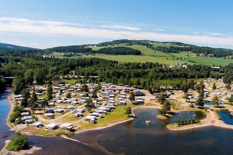
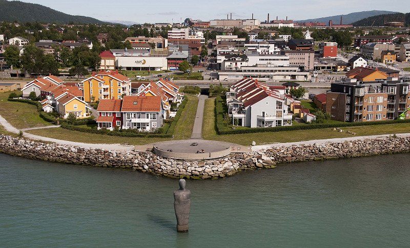
A trip to Norway is planned in 2022. We have always wanted to go here. During my military service I followed a cold weather training in Norway for 3 years. So we like to go to the places where I used to be. We are still preparing this trip. We are going in August.
Day
Boxtel, Nederland
51° 36' 5.2" N 5° 18' 43.8" E
51.6014370 5.3121773
• Head toward Nimrodlaan on Halderheiweg. Go for 486 m.
• Turn left onto Baandervrouwenlaan. Go for 374 m.
• Turn left onto Bosscheweg. Go for 1.4 km.
• Turn left and take ramp onto A2 toward 's-Hertogenbosch. Go for 7.2 km.
• Keep left onto A2 (St. Michielsgestel) toward Amsterdam/Utrecht. Go for 29.6 km.
• Take exit 14 toward Beesd. Go for 542 m.
• Turn right onto Katijdeweg toward Beesd/'s-Hertogenbosch/A2/Industrieterrein 6000-6500. Go for 233 m.
• Continue on Parkweg. Go for 308 m.
• Take the 1st exit from roundabout onto Parkweg toward Beesd. Go for 456 m.
• Turn left onto Homburg toward Industrieterrein 6000-6300. Go for 7 m.
• Turn right onto Parkweg. Go for 156 m.
• Continue on Wilhelminastraat. Go for 515 m.
• Turn right onto Jeugdlaan. Go for 55 m.
• Arrive at Jeugdlaan. Your destination is on the right.
☍
41,4 km
( 27 min.)
Beesd, Nederland
Pick up package for Norway.
4153 Beesd, Nederland
51° 53' 14.9" N 5° 11' 38.4" E
51.8874751 5.1940016
• Head toward Wilhelminastraat on Jeugdlaan. Go for 55 m.
• Turn left onto Wilhelminastraat. Go for 515 m.
• Continue on Parkweg. Go for 156 m.
• Turn left onto Homburg. Go for 7 m.
• Turn right onto Parkweg. Go for 410 m.
• Take the 1st exit from roundabout onto A2 toward 's-Hertogenbosch. Go for 4.3 km.
• Take the exit toward Nijmegen/Tiel onto A15. Go for 40.6 km.
• Take the exit toward Oberhausen onto A50. Go for 15.2 km.
• Take the exit toward Zwolle/Apeldoorn/Oberhausen/Arnhem onto A12/A50. Go for 6.5 km.
• Take the exit toward Apeldoorn/Zwolle onto A50. Go for 21.8 km.
• Take the exit toward Hengelo/Deventer onto A1. Go for 49.0 km.
• Take the exit toward Osnabrück/Enschede/Hengelo onto A1/A35. Go for 3.9 km.
• Continue on A1 toward Osnabrück/Hengelo/Borne. Go for 20.6 km.
• Take exit 34 toward De Lutte. Go for 505 m.
• Turn left onto Bentheimerstraat (N735). Go for 784 m.
• Turn right onto Bentheimerstraat. Go for 776 m.
• Turn right onto Bentheimerstraat. Go for 349 m.
• Turn left onto Bentheimerstraat. Go for 1.8 km.
• Continue on Hengeloer Straße (L39). Go for 1.4 km.
• Turn left onto K26. Go for 1.1 km.
• Pass 2 roundabouts and continue on Baumwollstraße (K26). Go for 1.1 km.
• Turn left and take ramp onto A30 toward Hannover/Osnabrück. Go for 62.3 km.
• Take exit 14 toward Bremen/Osnabrück-Hafen onto A1 (Hansalinie). Go for 202 km.
• Take exit 43 toward Flensburg/Kiel/Hamburg-West/Tötensen/Flughafen onto A261 (Buchholzer Dreieck). Go for 10.3 km.
• Continue on A7. Go for 11.6 km.
• Keep right onto A7. Go for 155 km.
• Take exit 2 toward Flensburg/Harrislee/Handewitt/Niebüll/Leck. Go for 332 m.
• Turn left onto B199. Go for 3.2 km.
• Turn right onto Lilienthalstraße (K19) toward Gewerbegebiet FL-Weiche/CITTI-PARK P+R. Go for 47 m.
• Turn right onto Lilienthalstraße. Go for 77 m.
• Turn left toward Schäferweg. Go for 130 m.
• Turn left onto Schäferweg. Go for 24 m.
• Turn left onto Schäferweg. Go for 104 m.
• Turn right. Go for 36 m.
• Arrive at your destination on the left.
☍
616,2 km
(5 hrs. 30 min.)
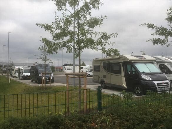
Wohnmobilstellplatz "Citti-Park" - Flensburg, Lilienthalstraße, Flensburg, Sleeswijk-Holstein, Duitsland
motorhome contact 62605
Great, free!, place to stay overnight on your way to Denmark. Groceries (large supermarket) and breakfast (at the bakery) across the street in the shopping center. The toilets in the shopping center can be used during opening hours. at night it is quiet and you are back on the highway in a few minutes.
https://www.citti-park-flensbu...
Lilienthalstraße 6, 24941 Flensburg, Duitsland
54° 46' 25.4" N 9° 23' 38.1" E
54.7737090 9.3939284
• Head toward Schäferweg. Go for 36 m.
• Turn left onto Schäferweg. Go for 104 m.
• Turn right onto Schäferweg. Go for 24 m.
• Turn right toward Lilienthalstraße. Go for 130 m.
• Turn right onto Lilienthalstraße. Go for 14 m.
• Turn slightly right onto Lilienthalstraße. Go for 115 m.
• Turn left onto Lilienthalstraße (K19). Go for 101 m.
• Turn left onto Lecker Chaussee (B199). Go for 3.1 km.
• Take ramp onto A7 toward Kolding. Go for 4.0 km.
• Continue on E45 (Sønderjyske Motorvej). Go for 89.5 km.
• Keep left onto E45 (Kolding) toward Århus/Vejle. Go for 205 km.
• Keep right onto E39 (Vendsyssel) toward Hirtshals/Hjørring/Brønderslev/Høvejen/Thisted. Go for 40.3 km.
• Take exit 4 toward Hjørring S. Go for 433 m.
• Turn right onto Brønderupvej (553) toward Sæby/Tårs/Hjørring Ø. Go for 632 m.
• Turn left onto Sæbyvej. Go for 3.2 km.
• Take the 2nd exit from roundabout onto Frilandsvej. Go for 1.1 km.
• Turn right onto Bispensgade. Go for 186 m.
• Continue on Broensvej. Go for 48 m.
• Continue on Bispensgade. Go for 41 m.
• Arrive at Bispensgade. Your destination is on the left.
☍
348,5 km
(3 hrs. 24 min.)
Day
Site code 9923 9800 Hjørring, Denemarken
Site code: 9923
Bredkærvej 89
9800, Hjorring, Denmark
57° 26' 26" N
10° 3' 26" E
57.44059
10.05735
9800 Hjørring, Denemarken
57° 27' 24.4" N 9° 59' 44.7" E
57.4567788 9.9957635
• Head north on Bispensgade.
• Continue on Tørholmsvej. Go for 1.0 km.
• Turn left onto Møllevej. Go for 522 m.
• Turn left onto Skagensvej. Go for 32 m.
• Turn right onto Nørrebro. Go for 250 m.
• Continue on Hirtshalsvej. Go for 2.2 km.
• Turn right onto Krustrupvej (55) toward Hirtshals. Go for 9.2 km.
• Turn left onto Strandvejen toward Tornby Strand. Go for 327 m.
• Arrive at Strandvejen. Your destination is on the right.
☍
13,5 km
( 15 min.)
Strandvejen 13, 9850 Hirtshals, Denemarken
Alternative 48625
Tornby Strand Camping Hirtshals, Denmark
57° 33' 19.2" N 9° 55' 59.6" E
57.5553470 9.9332290
• Head toward Marius Østergaardsvej on Strandvejen. Go for 327 m.
• Turn left onto Hovedvejen (55). Go for 1.4 km.
• Continue on Hovedvejen. Go for 2.6 km.
• Take the 1st exit from roundabout onto Søndergade. Go for 225 m.
• Turn left onto Lillehedenvej. Go for 359 m.
• Arrive at Lillehedenvej. Your destination is on the right.
☍
5,0 km
( 6 min.)
Day
Hirtshals, Denemarken
9850 Hirtshals, Denemarken
57° 35' 13" N 9° 58' 0.6" E
57.5869530 9.9668379
• Head toward Damsvej on Lillehedenvej. Go for 268 m.
• Turn left onto Skovvejen. Go for 61 m.
• Take the 1st exit from roundabout onto Østergade. Go for 511 m.
• Turn right onto Willemoesvej. Go for 153 m.
• Turn right onto Aalborgvej (E39) toward Hirtshals/Color Line. Go for 274 m.
• Keep left onto E39 toward Color Line/Check-in. Go for 783 m.
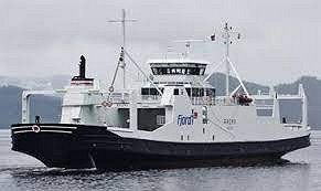
• Take the Hirtshals-Kristiansand Ferry. Stay on for 139 km.
• Head northwest. Go for 606 m.
• Take the 1st exit from roundabout onto Vesterveien toward Oslo/E18/Evje/9/Sentrum. Go for 361 m.
• Take the 2nd exit from roundabout onto E18 toward Oslo. Go for 2.5 km.
• Take ramp toward Lund Ø/Gimle. Go for 192 m.
• Enter the roundabout. Go for 58 m.
• Arrive at your destination on the right.
☍
144,7 km
(4 hrs. 11 min.)
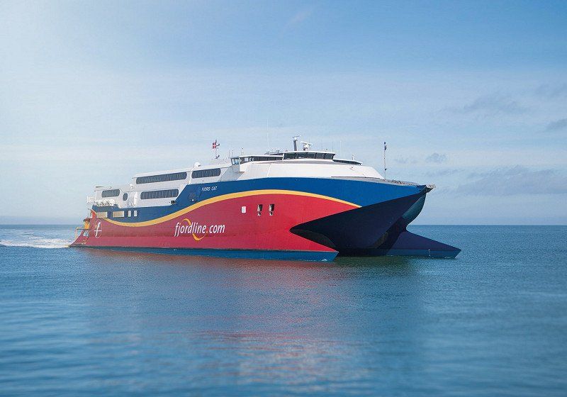
Oversteek met boot naar Kristiansand met de Fjordline
Crossing takes 2 hours and 15 minutes.
Kristiansand, Noorwegen
58° 9' 35.7" N 8° 1' 5.5" E
58.1599119 8.0182064
• Follow the roundabout. Go for 27 m.
• Take the 2nd exit from roundabout onto E18 toward Oslo. Go for 46.9 km.
• Take ramp toward Fevik/Vik. Go for 186 m.
• Take the 3rd exit from roundabout onto Vik (420) toward Fevik. Go for 2.1 km.
• Turn right onto Salverødveien. Go for 203 m.
• Turn slightly left onto Salverødveien. Go for 134 m.
• Turn right onto Salverødveien. Go for 63 m.
• Turn slightly left toward Grefstadveien. Go for 169 m.
• Turn right onto Grefstadveien. Go for 185 m.
• Turn left. Go for 438 m.
• Turn right toward Grefstadheia. Go for 415 m.
• Continue on Grefstadheia. Go for 58 m.
• Arrive at Grefstadheia. Your destination is on the left.
☍
50,9 km
( 37 min.)
Grefstadheia 1, 4885 Grimstad, Noorwegen
Deliver package to family.
58° 21' 42.2" N 8° 39' 40.7" E
58.3617351 8.6613156
• Head toward Grefstadvigveien on Grefstadheia. Go for 473 m.
• Turn left toward Grefstadveien. Go for 438 m.
• Turn right onto Grefstadveien. Go for 779 m.
• Turn right onto Fevikveien (420). Go for 4.5 km.
• Pass 2 roundabouts and continue on Vesterveien (420). Go for 2.0 km.
• Take the 2nd exit from roundabout. Go for 60 m.
• Take ramp onto E18 toward Oslo/Arendal. Go for 7.5 km.
• Take ramp toward Tromøy/409/Arendal. Go for 204 m.
• Take the 2nd exit from roundabout onto Langsæveien (410) toward Arendal/Tromøy/409. Go for 1.5 km.
• Pass 2 roundabouts and continue on Barbudalen (410). Go for 391 m.
• Take the 3rd exit from roundabout onto Møllebakken (410). Go for 314 m.
• Take the 1st exit from roundabout onto Kystveien. Go for 254 m.
• Turn right onto Skytebaneveien. Go for 195 m.
• Turn right onto Korketrekkeren. Go for 17 m.
• Arrive at Korketrekkeren. Your destination is on the right.
☍
18,6 km
( 22 min.)
Day
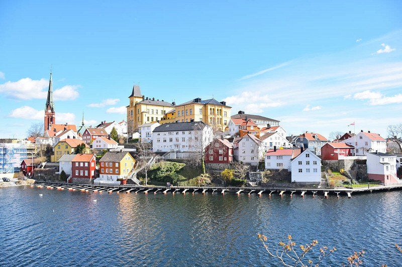
Arendal, Noorwegen
Arendal is a town in the Arendal municipality in the Norwegian county of Agder in southern Norway. In the center is the Tyholmen area with wooden houses from around 1600. The harbor is called Pollen, where you can find the fish market, cafes and restaurants.
58° 27' 42.3" N 8° 46' 20.8" E
58.4617568 8.7724499
• Head toward Skytebaneveien on Korketrekkeren. Go for 17 m.
• Turn right onto Skytebaneveien. Go for 115 m.
• Turn slightly right onto Mølleheia. Go for 194 m.
• Turn right onto Iuellsklev. Go for 121 m.
• Turn right toward Barbudalen/410. Go for 22 m.
• Take the 3rd exit from roundabout onto Barbudalen (410). Go for 256 m.
• Take the 3rd exit from roundabout onto 410. Go for 1.1 km.
• Take the 1st exit from roundabout onto Myreneveien (42). Go for 76 m.
• Take the 3rd exit from roundabout onto Myreneveien (42). Go for 668 m.
• Take the 4th exit from roundabout onto Frolandsveien (42). Go for 1.4 km.
• Take the 2nd exit from roundabout onto Frolandsveien (42). Go for 176 m.
• Turn right onto Frolandsveien (42). Go for 307 m.
• Pass 2 roundabouts and continue on Frolandsveien (42). Go for 6.6 km.
• Take the 2nd exit from roundabout onto Frolandsveien (42). Go for 1.0 km.
• Pass 2 roundabouts and continue on Frolandsveien (42). Go for 21.4 km.
• Continue on Telemarksveien (41/42) toward Evje/Åmli. Go for 2.6 km.
• Continue on Evjeveien (42) toward Evje. Go for 21 m.
• Arrive at Evjeveien (42). Your destination is on the left.
☍
36,1 km
( 37 min.)
Svenes, Noorwegen
58° 37' 1.2" N 8° 23' 38.7" E
58.6170070 8.3940900
• Head toward Telemarksveien on Evjeveien (42). Go for 21 m.
• Turn left onto Telemarksveien (41) toward 42. Go for 12.2 km.
• Turn right onto Dølemo (41) toward Åmli. Go for 11.1 km.
• Turn right onto Gata (3710). Go for 549 m.
• Turn right onto Kyrkjekleiva. Go for 10 m.
• Turn slightly left onto Haugvegen. Go for 67 m.
• Arrive at Haugvegen. Your destination is on the right.
☍
24,0 km
( 22 min.)
Route
Continue on road 41 to AMLI
Åmli, Noorwegen
Åmli is a village and municipality in fylke Agder in Norway. It is a typical rural community that largely consists of forest. In January 2017, Åmli had 1,856 inhabitants. The board is located in the village of Åmli, where about 600 people live.
58° 46' 6.4" N 8° 29' 11.5" E
58.7684458 8.4865146
• Head toward Kyrkjekleiva on Haugvegen. Go for 67 m.
• Turn slightly right onto Kyrkjekleiva. Go for 10 m.
• Turn right onto Gata (3710). Go for 227 m.
• Continue on Høgvollvegen (3716). Go for 18 m.
• Continue on 41. Go for 33.3 km.
• Turn right onto Tveitvegen. Go for 240 m.
• Turn sharp right toward Tveitvegen. Go for 15 m.
• Continue on Tveitvegen. Go for 14 m.
• Arrive at Tveitvegen. Your destination is on the left.
☍
33,9 km
( 30 min.)
Treungen, Noorwegen
Treungen is a village in and the administrative center of Nissedal Municipality, Telemark County in Norway. Located just east of the village of Tveitsund, it is part of the urban area of the same name, which has a population of 361 as of January 1, 2009.
59° 1' 17.5" N 8° 31' 25.5" E
59.0215279 8.5237506
• Head north on Tveitvegen. Go for 29 m.
• Turn sharp left onto Tveitvegen. Go for 240 m.
• Turn right onto Treungvegen (41). Go for 57.2 km.
• Turn right onto Brunkebergvegen. Go for 91 m.
• Arrive at Brunkebergvegen. Your destination is on the left.
☍
57,6 km
( 55 min.)
Brunkeberg, Noorwegen
Brunkeberg is a village in Kviteseid Municipality in Vestfold og Telemark County, Norway. The European route E134 which runs from Drammen to Haugesund passes through the village. The Brunkebergkerk is a white cruciform church from 1790
59° 26' 5.6" N 8° 29' 9.7" E
59.4348801 8.4860199
• Head toward Kviteseidvegen on Brunkebergvegen. Go for 91 m.
• Turn right onto Kviteseidvegen (41). Go for 271 m.
• Turn left onto Brunkebergvegen (E134) toward Haugesund/Haukeli. Go for 49.5 km.
• Turn right onto Jordivegen. Go for 150 m.
• Turn slightly right onto Uppistog Vinje. Go for 61 m.
• Arrive at Uppistog Vinje.
☍
50,1 km
( 42 min.)
Vinje, Noorwegen
Vinje is a municipality in Vestfold og Telemark county in southern Norway. The municipality had 3,726 inhabitants in January 2017.
Vinje is located in the Hjart valley, southeast of the plateau Hardangervidda. It borders Nore og Uvdal to the north, Tinn and Seljord to the east, Tokke and Bykle to the south, and Suldal, Odda and Ullensvang to the west.
59° 37' 14.3" N 7° 50' 41" E
59.6206302 7.8447236
• Head toward Jordivegen on Uppistog Vinje. Go for 61 m.
• Turn slightly left onto Jordivegen. Go for 150 m.
• Turn left onto Vinjevegen (E134). Go for 11.8 km.
• Turn left onto Raulandsvegen (37) toward Rjukan/Rauland. Go for 65.6 km.
• Turn left onto Skogvegen. Go for 179 m.
• Arrive at Skogvegen. Your destination is on the right.
☍
77,9 km
(1 hrs. 18 min.)
Route
Via road no: 37 to RJUKAN
Day
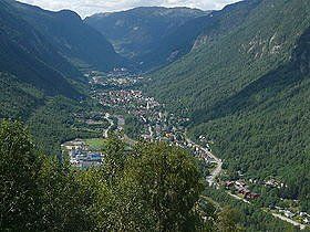
Rjukan, Noorwegen
Rjukan is a place in the municipality of Tinn in the county of Vestfold og Telemark in Norway. It is one of the few cities in Norway designed on the drawing board.
THE VILLAGE OF RJUKAN IN TELEMARK, SOUTH NORWAY
The town of Rjukan is located near the Hardanger National Park and is known for the famous Gaustatoppen (1833 meters) and its important role in the Second World War. Museums It with exhibitions about the industrial development of Norway and Rjukan in particular. Very special is the exhibition about Rjukan in the Second World War, especially about the resistance fighters who sabotaged the German plans to develop an atomic bomb in Vemork. The Tinn Museum, an open-air museum with buildings from the 16th to the 20th century. The mountain farms are still working as before. The Tinn Håndverksenter is a combination of art and home crafts exhibitions. Cable car Kitelsen. Very special is the Krossobanen, the first funicular in Northern Europe, built in 1928 and built for the population so that they could see the sun in winter. The cable car takes you to an altitude of 866 meters. At the top you have a beautiful view. www.krossobanen.no(link is external)
Nature
First of all, the Gaustatoppen with a height of 1883 meters above sea level. In clear weather you can see a sixth part of Norway! You can also take a train up to 860 meters up the mountain. The Hardangervidda is a vast mountain plateau, an untouched wilderness. The largest herd of wild reindeer in Northern Europe lives here. A beautiful area for the experienced hiker. The Rjukan Waterfall is 104 meters high and definitely worth a visit.
59° 52' 48.3" N 8° 36' 50.9" E
59.8800821 8.6141339
• Head southwest on Skogvegen. Go for 179 m.
• Turn left onto Sam Eydes gate (37). Go for 12.6 km.
• Continue on 364 toward 37/Hovin/Austbygde. Go for 19.0 km.
• Turn left onto Øvrebygde (3432). Go for 326 m.
• Continue on Bakko Nordre (3432). Go for 173 m.
• Continue on Øvrebygde (3432). Go for 131 m.
• Continue on Gunleiksbøen (3432). Go for 104 m.
• Continue on Øvrebygde (3432). Go for 751 m.
• Continue on 3432. Go for 353 m.
• Continue on Øvrebygde (3432). Go for 2.3 km.
• Continue on Nord Haukås (3432). Go for 117 m.
• Continue on Øvrebygde (3432). Go for 986 m.
• Turn right onto Skirvedalsvegen. Go for 17.7 km.
• Keep left. Go for 500 m.
• Turn right. Go for 202 m.
• Turn sharp right. Go for 234 m.
• Turn right toward 2794. Go for 4.5 km.
• Continue on 2794. Go for 186 m.
• Continue on Ligrendvegen (2794). Go for 431 m.
• Continue on 2794. Go for 309 m.
• Continue on Ligrendvegen (2794). Go for 123 m.
• Continue on 2794. Go for 163 m.
• Continue on Ligrendvegen (2794). Go for 922 m.
• Continue on 2794. Go for 1.3 km.
• Continue on Ligrendvegen (2794). Go for 645 m.
• Continue on 2794. Go for 91 m.
• Turn left onto 2796. Go for 975 m.
• Continue on Bølestveiten (2796). Go for 91 m.
• Continue on 2796. Go for 1.8 km.
• Continue on Kallerud (2796). Go for 141 m.
• Continue on 2796. Go for 3.6 km.
• Continue on Nordre Fossebrekke (2796). Go for 94 m.
• Continue on 2796. Go for 741 m.
• Turn left onto Norevegen (40). Go for 90.0 km.
• Enter the roundabout. Go for 43 m.
• Arrive at your destination on the right.
☍
161,9 km
(2 hrs. 44 min.)
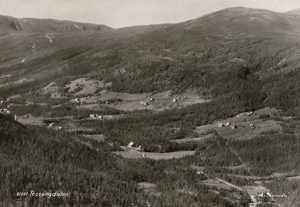
Route
Left to the north follow the Tessungdalen to the main road to GEILO
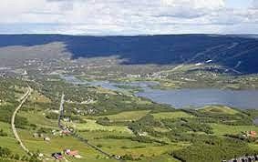
Geilo, Noorwegen
Geilo is a town in the county of Viken in southern Norway with about 2300 inhabitants. Geilo belongs to the municipality of Hol. It is located on the lake Ustedalsfjorden. Geilo is best known as a ski area, with 39 slopes, 20 ski lifts and about 220 km of cross-country trails.
60° 32' 1.1" N 8° 12' 31.7" E
60.5336513 8.2087948
• Follow the roundabout. Go for 24 m.
• Take the 2nd exit from roundabout onto Lienvegen (7). Go for 48.9 km.
• Take the 2nd exit from roundabout onto Lauvrudvegen (52) toward Lærdal/Hemsedal/Fagernes/Golsfjellet/Gol Sentrum. Go for 1.1 km.
• Turn right onto 51. Go for 83 m.
• Turn right onto Sentrumsvegen. Go for 125 m.
• Turn left onto Sentrumsvegen. Go for 497 m.
• Arrive at Sentrumsvegen. Your destination is on the left.
☍
50,7 km
( 43 min.)
Route
Eastbound road nr: 7 to GOL
Gol, Noorwegen
Gol is a municipality in the Norwegian province of Viken. The municipality had 4612 inhabitants in January 2017. Gol borders Ål, Hemsedal and Nes and Nord-Aurdal and Sør-Aurdal in Oppland county.
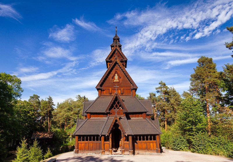
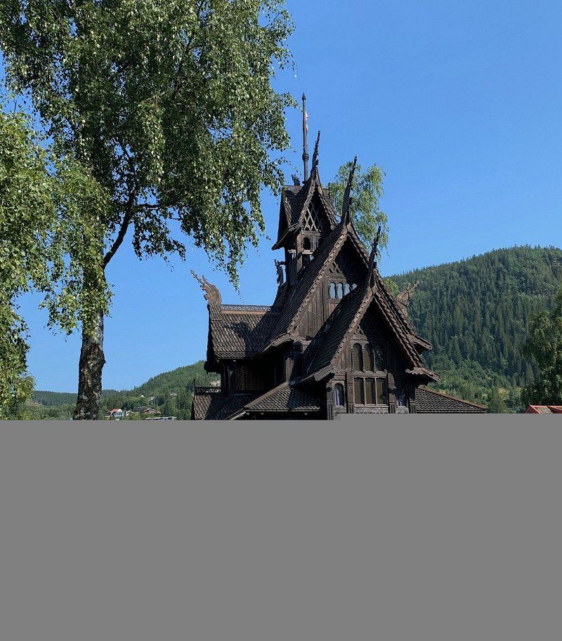
Located in the medieval park Gordarike, the Gol Stave Church is a faithful copy of the Gol Stave Church built in the 1200s. The example was built in the 1980s and consecrated by the Bishop of Tunsberg in 1994. summer evening on Wednesdays there is a devotional and sometimes musical performance. The church is often used for weddings. The woodwork in the church is still bright and it's easy to see all the beautiful carvings and details. Visit the church and be humbled by the mood with which you are greeted. Inside you can listen to the beautiful Gregorian choral music (CD). You can study the stave church architecture in the Viking Hall next to the exhibition. Same opening hours/entrance ticket as for the Gordarike Family Park. Gol Stave Church (Gol stavkirke) is a stave church originally from Gol, Hallingdal, Norway. It is now located in the Norwegian Museum of Cultural History in Bygdøy in Oslo, Norway. When the city built a new church around 1880, it was decided to demolish the old stave church. It was saved from destruction by the Society for the Preservation of Ancient Norwegian Monuments, who bought the materials to rebuild the church elsewhere. It was purchased by King Oscar II, who financed its relocation and restoration as the central building of his private open-air museum near Oslo. The restoration, overseen by architect Waldemar Hansteen, was completed in 1885. In 1907 this early open-air museum, the world's first, was merged with the Norwegian Museum of Cultural History, which now manages the stave church, still nominally owned by the reigning monarch . The church is dendrochronologically dated to 1212. In the 1980s,
60° 42' 5.5" N 8° 56' 43.1" E
60.7015342 8.9452964
• Head east on Sentrumsvegen.
• Take the 4th exit from roundabout onto Sentrumsvegen. Go for 572 m.
• Turn right onto Sentrumsvegen. Go for 95 m.
• Turn sharp right onto Valdresvegen (51). Go for 45.1 km.
• Take the 1st exit from roundabout onto Skulevegen. Go for 80 m.
• Turn right. Go for 21 m.
• Turn left. Go for 49 m.
• Turn right. Go for 36 m.
• Arrive at your destination on the left.
☍
46,0 km
( 43 min.)
Route
then to north road no: 51 to LEIRA
Elkjøp Valdres AS (tidl. Fagernes), Skulevegen, Leira i Valdres, Noorwegen
Leira is a place in the Norwegian municipality of Nord-Aurdal, province of Innlandet. Leira has 788 inhabitants (2007) and has an area of 1.22 km².
Skulevegen 2, 2920 Leira i Valdres, Noorwegen
60° 58' 10.9" N 9° 17' 28" E
60.9696884 9.2911062
• Head west. Go for 52 m.
• Turn right. Go for 48 m.
• Turn left toward Skulevegen. Go for 21 m.
• Turn left onto Skulevegen. Go for 53 m.
• Take the 1st exit from roundabout onto Golsvegen (51). Go for 119 m.
• Take the 1st exit from roundabout onto Oslovegen (E16). Go for 12.7 km.
• Turn left onto Tonsåslinna (33) toward Gjøvik/Dokka. Go for 38.3 km.
• Turn left onto Storgata. Go for 1.1 km.
• Turn left onto 250. Go for 44.9 km.
• Take the 1st exit from roundabout onto E6. Go for 3.1 km.
• Take the 1st exit from roundabout onto E6. Go for 8.8 km.
• Take ramp toward Gausdal/Stor-Hove/Fåberg. Go for 127 m.
• Take the 3rd exit from roundabout onto 255. Go for 290 m.
• Pass 2 roundabouts and continue on Gausdalsvegen (255). Go for 15.0 km.
• Arrive at Gausdalsvegen (255). Your destination is on the left.
☍
124,5 km
(1 hrs. 41 min.)
Day
Route
From here a small road to the north east to GAUSDAL SEGELSTAD- BRU
Segalstad bru, Noorwegen
Segalstad bru is a place in Gausdal Municipality, Innlandet County, Norway. Segalstad bru has 862 inhabitants and has an area of 1.17 km². It is the main town of the municipality.
61° 13' 41.5" N 10° 13' 21.2" E
61.2281931 10.2225502
• Head southeast on Gausdalsvegen (255). Go for 13.3 km.
• Take the 2nd exit from roundabout onto Gausdalsvegen (255). Go for 1.6 km.
• Take the 1st exit from roundabout onto E6. Go for 9.1 km.
• Take the 2nd exit from roundabout onto E6. Go for 21.9 km.
• Take the 3rd exit from roundabout onto Mjøsbrua (E6) toward Oslo/Hamar. Go for 31.3 km.
• Take the exit. Go for 270 m.
• Take the 3rd exit from roundabout onto Vangsvegen (25). Go for 10.4 km.
• Take the 2nd exit from roundabout onto Chausseen (25). Go for 183 m.
• Take the 2nd exit from roundabout onto 3. Go for 14.3 km.
• Turn right toward 25/2/Trysil/Elverum/Kongsvinger. Go for 534 m.
• Take the 1st exit from roundabout onto 25 toward 2. Go for 642 m.
• Pass 3 roundabouts and continue on Trysilvegen (25). Go for 65.8 km.
• Turn right onto 25/26 toward Karlstad/Sälen/Østby. Go for 560 m.
• Take the 2nd exit from roundabout onto 25 toward Sälen/Østby. Go for 23.3 km.
• Turn right onto 2168. Go for 6.9 km.
• Continue on 569. Go for 33 m.
• Continue on 2168. Go for 94 m.
• Continue on 569. Go for 14 m.
• Continue on Gränsbo. Go for 656 m.
• Continue on Nybo. Go for 1.8 km.
• Continue on Ängesåsen. Go for 2.9 km.
• Continue on Rörbäcksnäs. Go for 4.2 km.
• Continue on Vallsjön. Go for 5.2 km.
• Continue on Kråkbrickan. Go for 5.7 km.
• Continue on Kinnvallsjön. Go for 9.1 km.
• Continue on Bockmyrbäcken. Go for 7.4 km.
• Continue on Svarthammaren. Go for 856 m.
• Continue on Blästheden. Go for 391 m.
• Continue on Hammarsbyn. Go for 1.4 km.
• Continue on Hjulslätt. Go for 444 m.
• Continue on Sörnäs. Go for 691 m.
• Turn right onto Torgås (66). Go for 10.9 km.
• Turn left onto Bu toward Venjan. Go for 44 m.
• Turn right onto Bu. Go for 460 m.
• Turn left onto Buvalltäppan toward Venjan. Go for 15.2 km.
• Continue on Torsjöåsen. Go for 245 m.
• Continue on Juntlandsvägen. Go for 106 m.
• Continue on Torsjöåsen. Go for 324 m.
• Continue on Juntlandsvägen. Go for 7.5 km.
• Continue on Ogviksvägen. Go for 1.1 km.
• Continue on Hålltjärnsvägen. Go for 7.1 km.
• Continue on Moravägen. Go for 6.5 km.
• Continue on Solbodarna. Go for 1.6 km.
• Continue on Järpesbo. Go for 3.5 km.
• Continue on Vinäs. Go for 1.4 km.
• Continue on Rullbodarna. Go for 993 m.
• Continue on Vinäs. Go for 5.3 km.
• Continue on Sjöändan. Go for 64 m.
• Turn left onto Kättbo (E45). Go for 23.0 km.
• Turn right onto Ryssa bygata toward Ryssa/Leksand/Sollerön/Gesunda. Go for 1.5 km.
• Continue on Bönhusvägen. Go for 74 m.
• Continue on Ryssa bygata. Go for 3.0 km.
• Continue on Gesundavägen. Go for 1.8 km.
• Turn right onto Måstäppsvägen. Go for 1.2 km.
• Turn left onto Borrbergsvägen. Go for 2.8 km.
• Turn slightly left onto Övre Borrberg. Go for 438 m.
• Continue straight ahead. Go for 634 m.
• Turn slightly left. Go for 40 m.
• Arrive at your destination.
☍
337,9 km
(4 hrs. 16 min.)
RGXR+F9 Mångberg, Zweden
60° 50' 55.5" N 14° 32' 27.4" E
60.8487491 14.5409318
• Head east. Go for 704 m.
• Continue on Övre Borrberg. Go for 438 m.
• Turn slightly right onto Borrbergsvägen. Go for 2.8 km.
• Turn right onto Måstäppsvägen. Go for 1.2 km.
• Turn left onto Gesundavägen. Go for 3.3 km.
• Continue on Ryssa bygata. Go for 1.6 km.
• Continue on Bönhusvägen. Go for 23 m.
• Continue on Ryssa bygata. Go for 329 m.
• Turn left onto Budselvägen. Go for 1.5 km.
• Turn left onto E45. Go for 21.9 km.
• Turn right onto Sjöändan toward Venjan. Go for 64 m.
• Continue on Vinäs. Go for 5.3 km.
• Continue on Rullbodarna. Go for 993 m.
• Continue on Vinäs. Go for 4.6 km.
• Continue on Järpesbo. Go for 1.5 km.
• Continue on Solbodarna. Go for 2.5 km.
• Continue on Moravägen. Go for 4.4 km.
• Continue on Limavägen. Go for 7.1 km.
• Continue on Ogviksvägen. Go for 1.1 km.
• Continue on Hålltjärnsvägen. Go for 7.5 km.
• Continue on Torsjöåsen. Go for 324 m.
• Continue on Juntlandsvägen. Go for 106 m.
• Continue on Torsjöåsen. Go for 245 m.
• Continue toward Venjanvägen. Go for 2.9 km.
• Continue on Venjanvägen. Go for 12.3 km.
• Turn right onto Bu toward Ludvika/Salen/Limedsforsen. Go for 460 m.
• Turn left onto Bu. Go for 44 m.
• Turn right onto Bu (66) toward Sälen. Go for 10.9 km.
• Turn left toward Sörnäs. Go for 96 m.
• Continue on Sörnäs. Go for 595 m.
• Continue on Hjulslätt. Go for 444 m.
• Continue on Hammarsbyn. Go for 1.4 km.
• Continue on Blästheden. Go for 546 m.
• Continue on Svarthammaren. Go for 6.5 km.
• Continue on Bockmyrbäcken. Go for 9.8 km.
• Continue on Kinnvallsjön. Go for 921 m.
• Continue toward Kråkbrickan. Go for 3.1 km.
• Continue on Kråkbrickan. Go for 6.6 km.
• Continue on Vallsjön. Go for 3.7 km.
• Continue on Rörbäcksnäs. Go for 4.5 km.
• Continue on Ängesåsen. Go for 912 m.
• Continue on Nybo. Go for 942 m.
• Continue on Gränsbo. Go for 656 m.
• Continue on 569. Go for 14 m.
• Continue on 2168. Go for 94 m.
• Continue on 569. Go for 33 m.
• Continue on 2168. Go for 6.9 km.
• Turn left onto 25. Go for 23.2 km.
• Take the 2nd exit from roundabout onto 25/26. Go for 612 m.
• Turn left onto 25 toward Hamar/Elverum. Go for 63.8 km.
• Pass 4 roundabouts. Go for 3.0 km.
• Take the 2nd exit from roundabout onto 3 toward 25/E6. Go for 14.1 km.
• Take ramp onto Chausseen (25) toward Hamar/Løten. Go for 10.5 km.
• Take the 1st exit from roundabout onto E6. Go for 31.6 km.
• Take the 1st exit from roundabout onto Lillehammervegen (E6) toward Trondheim/Lillehammer. Go for 21.8 km.
• Take the 1st exit from roundabout onto E6. Go for 60.0 km.
• Arrive at Gudbrandsdalsvegen (E6). Your destination is on the right.
☍
372,6 km
(4 hrs. 47 min.)
Route
From here road nr: 255 north west to VINSTRA then south east to the north of RINGEBU
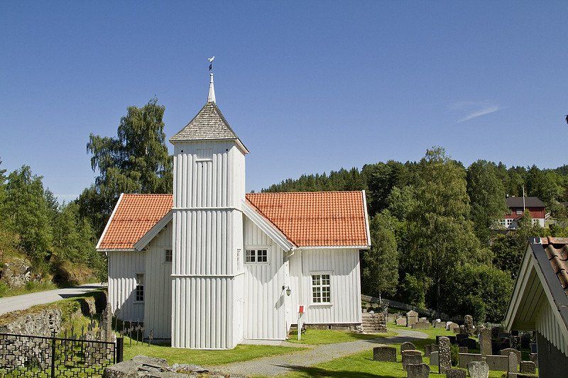
Ringebu, Noorwegen
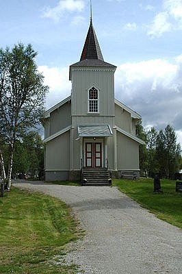
Ringebu is a municipality and ski resort in Gudbrandsdal in the Norwegian county of Innlandet. Ringebu borders Sør-Fron to the northwest, Gausdal to the southwest, Øyer to the south and Stor-Elvdal in Hedmark County to the east. Ringebu is located at 182 meters above sea level.
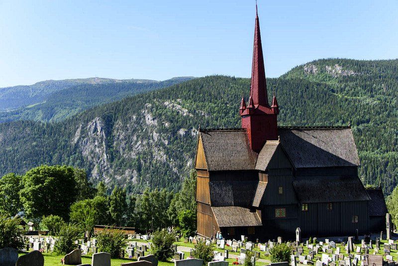
About Ringebu Stave Church Built in about 1220, this distinctive and much-photographed stave church is one of only 28 remaining in Norway. Once common, more than 1000 scattered across the countryside, with their unique style of architecture and construction, and they are symbolic of old Norway. Christianity was introduced to Norway around 1000 AD and about a thousand stave churches were built in the years that followed.
The original church was renovated in the 17th century when the distinctive red tower was added, and while the interior was painted white at one point, the original color has since been restored.
Ringebu Stave Church and the surrounding cemetery, amid hills and farmland, are strikingly beautiful, with immaculate grounds. A thoughtful touch is provided by the watering cans left at each tap for the use of people tending the graves, and these are clearly put to good use. Nearly every grave on the property has been planted with a small garden, and all are still lovingly maintained, making this a truly beautiful and distinctive resting place.
Traditionally built without the use of a single nail, they are composed of wood that has been skilfully swallowed, with vertical posts and wall planks resting on ground beams. Again, the use of tar to preserve the wood resulted in the loss and destruction by fire of many stave churches. Post holes have also been found here in Ringebu, indicating the presence of an even older church, with a cache of over 900 medieval coins found beneath the church, which have contributed to dating its construction.
The Rectory of Ringebu Built in 1743, the Rectory of Ringebu occupies a beautiful location north of the Ringebu Stave Church and was fully in use until 1991. Today, this monumental and restored rectory is a historic experience in itself. There are 5 buildings in the yard; the main building, two warehouses, staff quarters and an outbuilding.
Please note that the church may be closed in connection with church events, such as church services, weddings, funerals and the like
61° 31' 44.9" N 10° 8' 45" E
61.5291322 10.1458343
• Head northwest on Gudbrandsdalsvegen (E6). Go for 11 m.
• Turn right onto Brugata (2576) toward Atna/Friisvegen. Go for 549 m.
• Turn right onto Kjønnåsvegen (2578). Go for 3.7 km.
• Turn right onto Venabygdsvegen (27). Go for 32.8 km.
• Turn left onto 27. Go for 48.2 km.
• Arrive at 27.
☍
85,2 km
(1 hrs. 16 min.)
Route
Then via road nr 27 which splits to FOLLDAL.
Folldal, Noorwegen
Folldal is a municipality in the Norwegian county of Innlandet. The municipality had 1,577 inhabitants in January 2017. Folldal borders Oppdal and Tynset in the north, Alvdal in the east, Stor-Elvdal, Sør-Fron and Sel in the south and Dovre in the west.
Rondane National Tourist Route is one of 18 selected road sections in Norway. It runs from Muen and Sollia Church to Folldal.
The road follows the east side of the Rondane National Park and switches between cultural landscape and a majestic mountain range. The drive along the Blue Mountains is a journey of discovery in nature, culture and geology. At Atnasjøen you can experience the mighty view from the Sohlbergplassen. Take a walk to Fallfossen and the old Grimsa Bridge or take a break in the Strømbu Rest Area. The Rest Area is the starting point for walks from the east and for mountain walks in Alvdal Vestfjell and Breisjøseter Tourist Cabin. In Folldal you can visit the old Mining Company and enjoy the panorama from the viewpoint.
FROM THE SOUTH
Gateway Ringebu: If you drove from Oslo on the E6 highway, the Rondane National Tourist Route can start from Ringebu. From there you can drive over the mountains, Venabygdsfjellet, and down where you can choose to head towards Hjerkinn in the west and Alvdal in the east.
Gateway Atna: If you are on route no. 3 from Elverum you can start from Atna and drive northwest. Here too you can choose whether you drive towards Hjerkinn or Alvdal.
FROM THE NORTH
Hjerkinn Port: Departing from Dovrefjell and west, Hjerkinn is an excellent gateway for your journey along the Rondanevegen. From the mountain plateau on Dovrefjell, the route leads to Folldal. After a few kilometers you can already see the contours of the Rondane mountains on the right.
Gateway Alvdal: If you're coming from the northeast and Røros or maybe from Sweden, start from Alvdal. While driving you will see the beginning of the Rondane mountains to the east and from Folldal you will drive through the characteristic landscape for which the Rondane mountains are known.
62° 7' 56.8" N 9° 59' 48.5" E
62.1324578 9.9967955
• Head northwest on 27.
• Turn right onto Folldalsvegen (29). Go for 40.4 km.
• Turn right onto 3. Go for 1.6 km.
• Take the 2nd exit from roundabout onto 3. Go for 809 m.
• Turn left onto Skulbakken. Go for 25 m.
• Continue on Steia. Go for 108 m.
• Turn right onto Steia. Go for 191 m.
• Arrive at your destination.
☍
43,1 km
( 36 min.)
Route
RONDANE National Park road no: 29 east to ALFDAL
Alvdal, Noorwegen
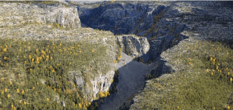
Alvdal is a village in Alvdal Municipality, Innlandet County, Norway. Alvdal has 667 inhabitants and has an area of 1.63 km². It is the seat of the municipal council. The village is located where the River Folla flows into the Glomma. The village has a station at Rørosbanen.
The largest gorge in Northern Europe, formed during the last ice age, about 10,000 years ago. You can experience the Jutulhogget Gorge on foot by descending the steep trail, or you can enjoy the view from the edge.
62° 6' 30.8" N 10° 38' 2.7" E
62.1085597 10.6340715
• Head northeast.
• Turn left onto Müllergata. Go for 523 m.
• Turn slightly right toward Müllergata. Go for 50 m.
• Turn right onto 2222. Go for 2.2 km.
• Continue on Tronstad (2222). Go for 108 m.
• Continue on 2222. Go for 904 m.
• Continue on Nordli (2222). Go for 103 m.
• Continue on 2222. Go for 985 m.
• Continue on Rognset (2222). Go for 102 m.
• Continue on 2222. Go for 263 m.
• Continue on Nygarden (2222). Go for 99 m.
• Continue on 2222. Go for 242 m.
• Continue on Skreda (2222). Go for 101 m.
• Continue on 2222. Go for 2.4 km.
• Continue on Tronly (2222). Go for 66 m.
• Continue on 2222. Go for 4.8 km.
• Continue on Aumveien (2222). Go for 8.7 km.
• Continue on Kongsveien (2222). Go for 1.5 km.
• Turn right onto Parkveien (2222). Go for 277 m.
• Enter the roundabout. Go for 35 m.
• Arrive at your destination on the left.
☍
23,4 km
( 22 min.)
Route
Then via the E3 to the north towards TYNSET
Tynset, Noorwegen
Tynset is a municipality in the Norwegian county of Innlandet. The municipality had 5584 inhabitants in January 2017. The municipal council is located in the town of the same name.
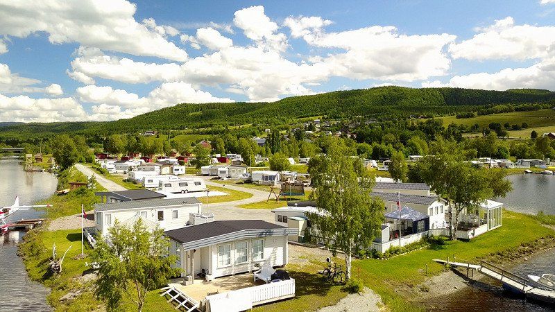
Tynset Rom & Camping is idyllically located next to the river "Glomma", directly over the bridge and centrally located in the center of Tynset. Here you will find accommodation in rooms, apartments and cabins, ranging from simple to luxurious. There is also a large site with electricity that can accommodate caravans, motorhomes and tents.
Tynset Rom & Camping is idyllically located next to the river "Glomma", directly over the bridge and centrally located in the center of Tynset. Here you will find accommodation in rooms, apartments and cabins, ranging from simple to luxurious. There is also a large site with electricity that can accommodate caravans, motorhomes and tents.
62° 16' 33.5" N 10° 46' 57.1" E
62.2759715 10.7825389
• Follow the roundabout. Go for 17 m.
• Take the 2nd exit from roundabout onto Ringveien (30). Go for 536 m.
• Take the 1st exit from roundabout onto Brugata (30). Go for 623 m.
• Take the 1st exit from roundabout onto Rørosveien (30). Go for 41.0 km.
• Take the 2nd exit from roundabout onto Rørosveien (30) toward Røros. Go for 12.4 km.
• Take the 2nd exit from roundabout onto Osloveien (30) toward Trondheim/Sentrum. Go for 364 m.
• Turn right onto Kjerkgata. Go for 54 m.
• Turn left onto Peder Hiortgata. Go for 40 m.
• Turn right onto Tufta. Go for 104 m.
• Turn right onto Henrik Grønns vei. Go for 67 m.
• Turn right onto Kjerkgata. Go for 95 m.
• Arrive at Kjerkgata. Your destination is on the right.
☍
55,3 km
( 48 min.)
Route
Right turn no.: 30 to ROROS
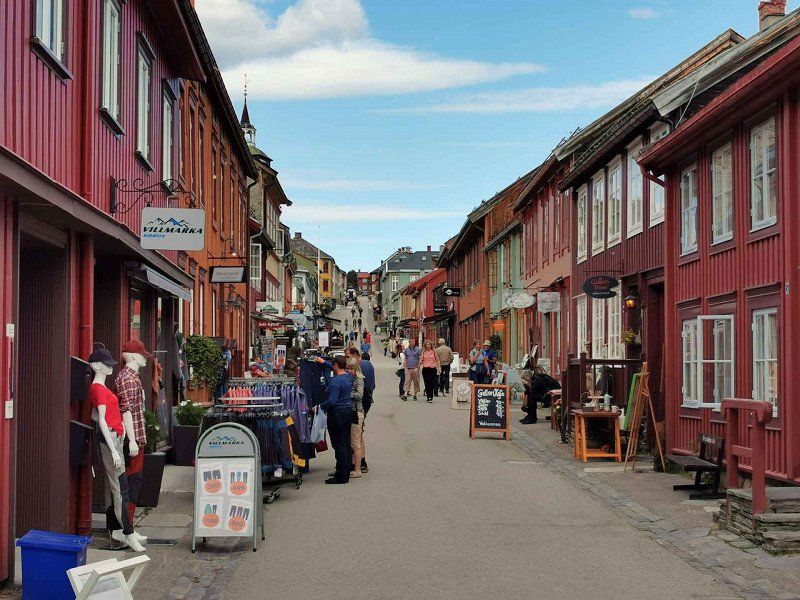
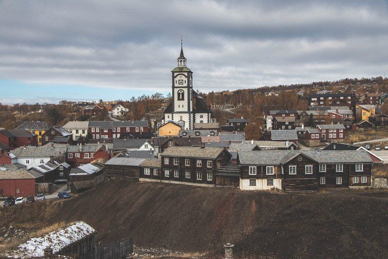
Røros, Noorwegen
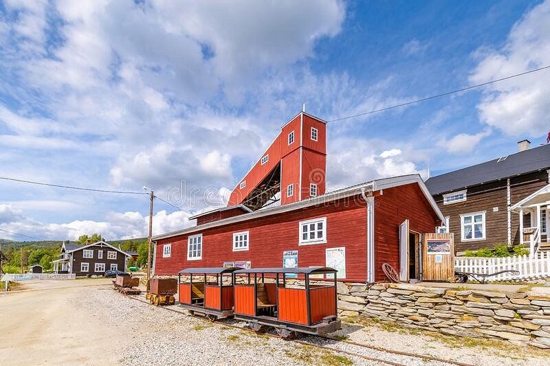
Røros is a town and municipality in the Norwegian county of Trøndelag. The municipality had 5623 inhabitants in January 2017. Røros is the highest town in Norway, at 628 meters above sea level. It has a station on Rørosbanen to Trondheim. Just west is the airport.
Røros is tucked away in inland Norway, not far from the border with Sweden. It is not an undiscovered village, as UNESCO listed it as a World Heritage Site in the 1980s, but arriving in Røros feels like walking into a fairytale, as if time has stood still here. Colorful wooden houses with white snowy roofs. Horse and carriage pass with ringing bells. Everywhere you look it is white and every house looks like you want to live there. A village from a winter fairytale.
It's actually quite special that people live in Røros, because it can get incredibly cold here. The record is about 50 degrees below zero, but on average it is minus 30 here in winter. The reason that Røros is still inhabited has to do with the history of the village. Long ago copper was discovered in the ground here and that turned out to be the jackpot. Røros and the surrounding area are now on the UNESCO World Heritage List for the mining history of this area.
To get there, you have to make a long journey, because it also takes about three hours by road from Trondheim (the nearest large city), but the nice thing is that the journey itself is a special experience in itself.
The figurehead of Røros is of course the striking church that can be seen from almost anywhere in the village. It was a gift from the mine bosses to the inhabitants of the village, with exactly as many seats as there were residents at the time. Nice to see inside and out, but the real nice part of Røros is of course the small streets downtown. Behind every door there is something special: a store with warm clothing or home accessories, a coffee bar to warm up with hot chocolate or maybe you step into a Norwegian cafe. Anyone who has ever seen Pippi Longstocking's films may recognize one of the streets. Not all wooden houses in the village are inhabited, but most of the windows have a poinsettia and so there is life indoors.
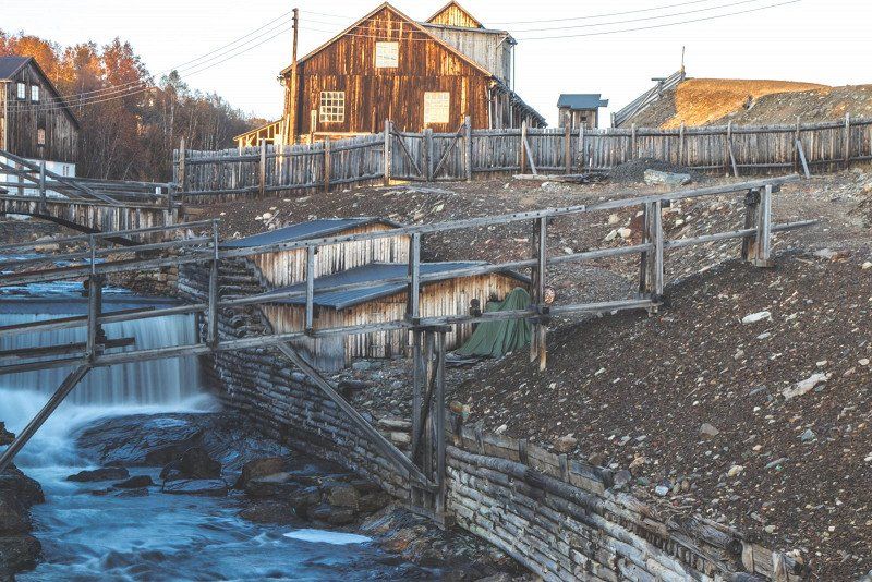
The mining museum
For a long time, life in this area was completely occupied by the copper mines. In the museum, in the middle of the old town, you can learn something about this time. You can see how incredibly hard it was for the miners here, because they had to work hard under harsh conditions. It is part of the history of Røros and is well worth a visit!
62° 34' 29.3" N 11° 23' 2.8" E
62.5748112 11.3841068
• Head toward Peder Hiortgata on Kjerkgata. Go for 67 m.
• Turn left onto Osloveien (30). Go for 326 m.
• Take the 3rd exit from roundabout onto Falunveien (31) toward Funäsdalen/Brekken. Go for 1.6 km.
• Turn right onto Svenskveien (31) toward Funäsdalen/Brekken/705/Stjørdal. Go for 32.1 km.
• Turn left onto Aursundveien (705) toward Stjørdal/Tydal/Glåmos/30. Go for 110 m.
• Turn right onto Brekkmoen. Go for 51 m.
• Turn left onto Brekkmoen. Go for 28 m.
• Arrive at Brekkmoen. Your destination is on the right.
☍
34,3 km
( 30 min.)
Day
Brekken, Noorwegen
Breken, is a place and former municipality in Norway. The municipality was located in what was then Sør-Trøndelag County. The municipality was founded in 1926 as a split from Røros. In 1964 the municipality was again added to Røros. The old congregation still exists as a parish of the Norwegian Church.
62° 38' 49.9" N 11° 52' 0.9" E
62.6471925 11.8669281
• Head north on Brekkmoen. Go for 128 m.
• Turn left onto Brekkmoen. Go for 48 m.
• Turn right onto Aursundveien (705). Go for 107 km.
• Arrive at Gjelbakken (705). Your destination is on the right.
☍
107,4 km
(1 hrs. 29 min.)
Route
(to Myrmoen) then north on road mr: 705 from SELBU to ST JORDAL
Selbu, Noorwegen
Selbu is a municipality in the Norwegian county of Trøndelag. The towns of Mevangen and Trøa are part of the municipality. The municipality had 4,098 inhabitants in January 2017. Surrounding municipalities are Tydal in the south and Malvik in the north.
63° 13' 9.3" N 11° 2' 28.6" E
63.2192454 11.0412901
• Head toward Hårstadvegen on Gjelbakken (705). Go for 35.8 km.
• Turn left onto Woldsethbakken (705). Go for 31 m.
• Take ramp. Go for 116 m.
• Continue on 950. Go for 406 m.
• Continue toward 705. Go for 34 m.
• Take the 2nd exit from roundabout onto 950. Go for 355 m.
• Take the 4th exit from roundabout. Go for 285 m.
• Take ramp onto Værnestunnelen (E6). Go for 1.7 km.
• Keep right toward Sundsvoll/Meråker/Sentrum. Go for 99 m.
• Continue on E14. Go for 105 m.
• Take the 2nd exit from roundabout onto Innherredsvegen (6806). Go for 171 m.
• Turn right onto Kjøpmannsgata. Go for 139 m.
• Turn right onto Parkvegen. Go for 29 m.
• Arrive at Parkvegen. Your destination is on the right.
☍
39,2 km
( 36 min.)
Day
Stjørdal, Noorwegen
Stjørdal is a municipality in the Norwegian county of Trøndelag. The municipality had 23,625 inhabitants in January 2017. Stjørdal's coat of arms contains a tapeworm.
The Stjørdalsfjord is an arm of the Trondheimsfjord that extends east to the mouth of the Stjørdalselva River at the head of the fjord. The Stjørdal Delta has for the most part developed into Stjørdal town, industrial areas and an airport. Fragments of the original delta habitats are more or less intact, but still attract a number of wetland species during migration, both at the estuary and along the river.
63° 28' 4.1" N 10° 55' 3.3" E
63.4677972 10.9175960
• Head south on Parkvegen. Go for 39 m.
• Turn left toward E14. Go for 86 m.
• Turn right onto E14 toward E6. Go for 147 m.
• Take the 2nd exit from roundabout onto E14 toward E6. Go for 144 m.
• Turn right onto Tangtunnelen (E6) toward Narvik. Go for 966 m.
• Pass 3 roundabouts and continue on Riksvegen (E6). Go for 21.5 km.
• Take the 1st exit from roundabout onto Breivegen (E6). Go for 2.8 km.
• Turn right toward Gamle Kongeveg Sør/6854. Go for 387 m.
• Take the 1st exit from roundabout onto Gamle Kongeveg Sør (6854). Go for 1.3 km.
• Continue on Gamle Kongeveg Sør (6854). Go for 3.8 km.
• Continue on 6854. Go for 227 m.
• Continue on 79. Go for 73 m.
• Continue on 6854. Go for 54 m.
• Continue on Kirkaunbakken (6854). Go for 22 m.
• Continue on Gamle E6 (6854). Go for 176 m.
• Turn left onto Eknesvegen (6856). Go for 940 m.
• Turn right and take ramp onto E6 toward E6 N. Go for 8.9 km.
• Pass 9 roundabouts and continue on Kvamsvegen (E6). Go for 312 km.
• Take the 1st exit from roundabout onto E6 toward Narvik. Go for 1.2 km.
• Take the 1st exit from roundabout onto Vollanvegen (E6) toward Narvik. Go for 4.3 km.
• Take the 2nd exit from roundabout onto E6. Go for 59.1 km.
• Arrive at Europavegen (E6). Your destination is on the left.
☍
417,7 km
(5 hrs. 32 min.)
E6 4, 8643 Bjerka, Noorwegen
NAFCamp camping - pitches on water - mini kiosk - supermarket 300m - center 750m.
Was stationed here during its time as a Marine 1984 cold weather training.
E6 4, 8642 Finneidfjord, Noorwegen
66° 12' 33" N 13° 48' 17.2" E
66.2091528 13.8047870
• Head southwest on Europavegen (E6). Go for 8.6 km.
• Turn left onto Nergårdsgata. Go for 214 m.
• Turn right onto Rønningveien. Go for 34 m.
• Turn right onto Smibakkveien. Go for 93 m.
• Arrive at Smibakkveien. Your destination is on the left.
☍
8,9 km
( 7 min.)
Day
Bjerka, Noorwegen
Bjerka is a place in Hemnes Municipality, Nordland County, Norway. Bjerka has 428 inhabitants and has an area of 0.89 km².
NAFCamp camping - pitches on water - mini kiosk - supermarket 300m - center 750m.
66° 8' 46" N 13° 50' 6" E
66.1461112 13.8350048
• Head southeast on Smibakkveien. Go for 10 m.
• Turn right onto Smibakkveien. Go for 392 m.
• Turn right onto Nergårdsgata. Go for 119 m.
• Turn left onto Nergårdsgata. Go for 43 m.
• Turn right onto E6. Go for 29.0 km.
• Take the 2nd exit from roundabout onto E6 toward Narvik. Go for 102 m.
• Take the 2nd exit from roundabout onto Ole Tobias Olsens gate toward Sentrum. Go for 63 m.
• Continue on Sørlandsveien. Go for 134 m.
• Take the 2nd exit from roundabout onto Ole Tobias Olsens gate. Go for 288 m.
• Take the 3rd exit from roundabout onto Kirkegata. Go for 419 m.
• Take the 1st exit from roundabout onto Lars Meyers gate. Go for 435 m.
• Turn left onto Doktorbakken. Go for 150 m.
• Turn right onto Skoginspektør Nilsens vei. Go for 46 m.
• Turn right onto Lensmann Hansens gate. Go for 39 m.
• Arrive at Lensmann Hansens gate. Your destination is on the right.
☍
31,2 km
( 29 min.)
Day
Mo i Rana, Noorwegen
Mo i Rana is a town in Rana Municipality on the Ranfjord in Nordland in northern Norway. To the south is Mosjøen and to the north Fauske. It is the fourth largest city in northern Norway, with approximately 18,000 inhabitants. The city is located just south of the Arctic Circle at 66.5° N
Mo i Rana
Mo i Rana is a town in Rana Municipality on the Ranfjord in Nordland in northern Norway. The town is located north of Mosjøen and south of Fauske. It is the fourth largest city in northern Norway. The city is located just south of the Arctic Circle.
caves
Near Mo i Rana are more than 200 caves, the most famous of which are the Setergrotta and Grønli Cave. The latter is the most visited limestone cave in Norway.
Sights
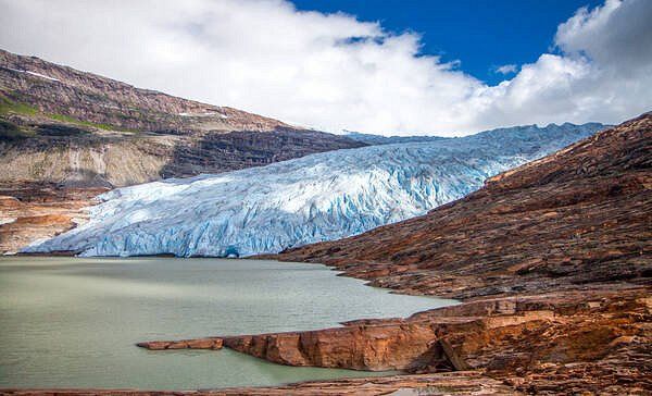
In addition to a visit to the caves, a visit to the Arctic Circle Center is a good option. In addition, a visit to the Saltfjellet-Svartisen National Park with the Svartisen glacier and the Engabreen tributary is a must. For those interested, Mo i Rana is a branch of the National Library of Norway.
Mo i Rana Camping
Mo i Rana Camping is a campsite in Mo i Rana (Nordland, Norway), located a river/stream. The campsite is used by many people as a place to stay overnight on the way to the North Cape. The campsite has which are marked out and pitches without shade. It is possible to rent hikers' cabins, rooms and apartments. In the vicinity you can swim in the river/stream. It is possible to use the internet, because the campsite has one or more computers with an internet connection and there is a wifi point.
The Nordlandsbanen train route passes Mo i Rana and there is an airport, Mo i Rana Airport. Traffic and transport are done via the E6.
https://viatioga.nl/voorpret/b...
66° 18' 49.4" N 14° 8' 31.1" E
66.3137122 14.1419749
• Head toward Skolegata on Lensmann Hansens gate. Go for 128 m.
• Turn right onto Skolegata. Go for 98 m.
• Turn left onto Lars Meyers gate. Go for 184 m.
• Continue on Nordlandsveien. Go for 533 m.
• Take the 2nd exit from roundabout onto Skansen. Go for 217 m.
• Take the 2nd exit from roundabout onto E6. Go for 982 m.
• Pass 2 roundabouts and continue on Selforsveien (E6). Go for 504 m.
• Take the 1st exit from roundabout onto Saltfjellveien (E6) toward Narvik. Go for 173 km.
• Take the 1st exit from roundabout onto Storgaten (E6) toward Narvik. Go for 416 m.
• Take the 1st exit from roundabout onto Follaveien (E6) toward Narvik. Go for 117 km.
• Take the 2nd exit from roundabout onto E6. Go for 11.5 km.
• Turn right onto Dragsarmen (827) toward Narvik/Ferge Kjøpsvik/Drag. Go for 4.4 km.
• Turn left onto 827. Go for 41 m.
• Take the Drag-Kjøpsvik Ferry. Stay on for 13.9 km.
• Head northeast on Kjøpsvikveien (827). Go for 466 m.
• Take the 2nd exit from roundabout onto 827. Go for 954 m.
• Take the 2nd exit from roundabout onto Kjøpsvikveien (827). Go for 33.5 km.
• Turn right onto Efjord-E6 (E6). Go for 22.0 km.
• Pass 3 roundabouts and continue on E6. Go for 41.0 km.
• Enter the roundabout. Go for 17 m.
• Arrive at your destination on the right.
☍
421,0 km
(6 hrs. 3 min.)
Day
Alternatief via Bodø veerboot kade - Moskenes veerboot kade -
https://autopassferje.no/priser/
Torghatten Nord AS (torghatten-nord.no)
http://www.torghatten-nord.no
https://autopassferje.no/priser/?lang=en
https://autopassferje.no/prise...
Day
Narvik, Noorwegen
Narvik is a municipality in Nordland county in Norway that acquired city rights in 1902. The city has 18,630 inhabitants. With its location at 68° north latitude, it is the northernmost city in Europe with a railway station after Murmansk in Russia, which is slightly more northerly.
The town of Narvik is located in Northern Norway and is surrounded by majestic nature. High mountains tower over the blue Ofotfjord and are perfect for hiking and skiing. In winter, the Northern Lights dance across the sky at night, and the midnight sun makes for long, clear summer nights.
From Narvik you can hop on one of the most beautiful train journeys in the world on the Ofoten Railway. It was built by the navvies at the end of the 19th century. During the journey you can see traces of the Battle of Narvik which took place during the Second World War. You will learn more about it at the Narvik War Museum.
The Polar Park in Narvik is the northernmost zoo in the world. Admire animals such as wolves, lynx and bears, as well as reindeer, moose and arctic foxes.
Narvik is currently undergoing the process of obtaining the Sustainable Destination Certificate, a seal of approval awarded to destinations that systematically try to counteract the negative impact of tourism.
Detailed travel information can be found on Narvik's official website. https://www.visitnarvik.com/
68° 26' 18.6" N 17° 25' 38.1" E
68.4384984 17.4272612
• Follow the roundabout. Go for 39 m.
• Take the 3rd exit from roundabout onto Kongensgate (E6). Go for 1.8 km.
• Pass 2 roundabouts and continue on Leirvik (E6/E10). Go for 14.2 km.
• Enter the roundabout. Go for 19 m.
• Arrive at your destination on the right.
☍
16,0 km
( 14 min.)
Bjerkvik, Noorwegen
Bjerkvik is a place in Narvik Municipality, Nordland County, Norway. Bjerkvik has 1195 inhabitants and has an area of 1.42 km². Bjervik includes hotels, supermarkets, rental car service and a comprehensive school with kindergarten, primary, secondary and gymnasium.
68° 32' 57.5" N 17° 33' 27" E
68.5492955 17.5575034
• Follow the roundabout. Go for 15 m.
• Take the 2nd exit from roundabout onto Kong Olavs vei (E10). Go for 60.5 km.
• Take the 2nd exit from roundabout onto Tjeldsundveien (E10) toward Sortland/Lødingen/Å i Lofoten. Go for 32.5 km.
• Take the 1st exit from roundabout onto Kong Olavs vei (E10). Go for 15.9 km.
• Turn right onto Kong Olavs vei (E10). Go for 18.1 km.
• Take the 3rd exit from roundabout onto E10. Go for 79.6 km.
• Take the 1st exit from roundabout onto Kong Olavs vei (E10). Go for 29.7 km.
• Turn left onto Valbergsveien (815). Go for 21.4 km.
• Turn right onto Valbergsveien. Go for 130 m.
• Arrive at Valbergsveien.
☍
257,7 km
(3 hrs. 41 min.)
Day
Lofoten, Noorwegen
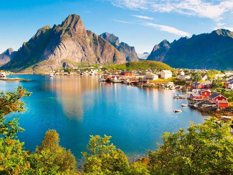
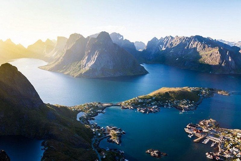
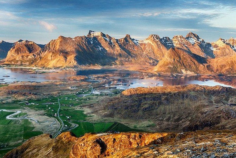
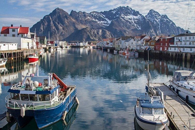
The Lofoten are an archipelago off the coast of Nordland county in northern Norway. The Lofoten consists of a number of islands. The best known are: Røst Værøy Gimsøya Moskenesøya Vestvågøy Austvågøy Flakstadøya Some places on the Lofoten are Svolvær, Leknes, Vågan, Ramberg, Moskenes and Reine.
The Lofoten
The Lofoten are sometimes jokingly referred to as 'the Norwegian Maldives'. The comparison lies in the unprecedented island splendor, because the weather is different here (although the cold is not too bad, see below!). The Lofoten are located well above the Arctic Circle in the middle of the North Sea. The landscape of the island archipelago is of pristine, magical beauty; an untouched wilderness full of wild mountain ranges, deep fjords, long sandy beaches and idyllic fishing villages with typical red houses. The Lofoten is also ideal for outdoor enthusiasts: you can go hiking, kayaking, rafting, whale watching, skiing, climbing, fishing and even surfing.
The main islands of Austvågøy, Vestvågøy, Flakstadøy and Moskenesøy are separated from the mainland by the sea of Vestfjorden, but are all connected by bridges and tunnels. One of the best ways to discover the islands is via the E10, a winding road that covers all corners of the islands.
Lofoten highlights and sights
The main attraction of Lofoten is the overwhelmingly beautiful landscape. Some of the best activities include kayaking in the golden midnight sun, rafting in the Trollfjord (where you'll almost certainly spot the mighty sea eagle, seals and countless seabirds!) and of course the Northern Lights safaris. Furthermore, there are countless remote characteristic fishing villages on the Lofoten with typical red fishermen's houses on the water (some of them converted into residential accommodation!). Of course you will find some of the best fishing waters on earth.
Lofoten towns and accommodation
The largest and most important town in Lofoten is Svolvær (population 5,000), which is also where the Hurtigruten (the famous Norwegian Coastal Express boat) moors. A bit more atmospheric is nearby Kabelvåg, which, like Svolvær, is located on the main island of Austvågøy. The town of Leknes (approx. 3000 inhabitants) on the central island of Vestvågøy is considered an unofficial 'capital town', it is also the only hospital in the region.
The village of Henningsvær is spread over several small islands, which is especially popular for its special location. Another much-photographed fishing village is the more remote and very picturesque Reine on Moskenesøy, arguably the prettiest of them all. Close to Reine – on a small island between two bridges – is the equally photogenic Hamnoy, with its beautiful harbor.
68° 12' 31" N 13° 54' 56.7" E
68.2086069 13.9157370
• Head south on Valbergsveien. Go for 130 m.
• Turn left onto Valbergsveien (815). Go for 21.4 km.
• Turn right onto Grundstadveien (E10). Go for 29.7 km.
• Take the 3rd exit from roundabout onto Kong Olavs vei (E10). Go for 79.5 km.
• Take the 1st exit from roundabout onto Kong Olavs vei (E10). Go for 18.2 km.
• Turn left onto Kong Olavs vei (E10). Go for 15.8 km.
• Take the 1st exit from roundabout onto Kong Olavs vei (E10). Go for 32.5 km.
• Take the 1st exit from roundabout onto Kong Olavs vei (E10) toward Narvik/Evenes Lufthavn. Go for 60.5 km.
• Pass 3 roundabouts and continue on Rombaksveien (E6). Go for 16.0 km.
• Arrive at Kongensgate (E6). Your destination is on the right.
☍
273,6 km
(4 hrs. 8 min.)
Day
Rasteplass, E10, 8326 Myrland, Noorwegen
Day
Day
Narvik, Noorwegen
68° 26' 18.6" N 17° 25' 38.1" E
68.4384984 17.4272612
• Head southwest on Kongensgate (E6). Go for 3 m.
• Take the 3rd exit from roundabout onto Kongensgate (E6). Go for 1.8 km.
• Take the 2nd exit from roundabout onto E6 toward Alta. Go for 5.6 km.
• Take the 1st exit from roundabout onto Leirvik (E6/E10) toward Kiruna. Go for 6.4 km.
• Turn left onto Nygård (E10) toward Luleå. Go for 27.4 km.
• Continue on E10. Go for 129 km.
• Pass 3 roundabouts and continue on E10. Go for 6.7 km.
• Take the 3rd exit from roundabout onto E10. Go for 105 km.
• Turn right onto Inlandsvägen (E45) toward Flygplats/Gällivare. Go for 8.7 km.
• Take the 2nd exit from roundabout onto Nuolajärvivägen toward E10/Luleå/Gällivare. Go for 1.8 km.
• Take the 2nd exit from roundabout onto Luleåvägen. Go for 207 m.
• Continue on Lasarettsgatan. Go for 307 m.
• Take the 3rd exit from roundabout onto Parkgatan (E45). Go for 93.2 km.
• Turn right onto Föreningsgatan. Go for 15 m.
• Turn left onto Klockartorget. Go for 115 m.
• Arrive at Klockartorget. Your destination is on the right.
☍
385,8 km
(4 hrs. 42 min.)
Vanuit NARVIK naar E10 over Zweden?
Let's make a cut here to the south.
From NARVIK to E10 over Sweden?
Zweden E10 Sakajärvi naar de E45
Sweden E10 Sakajärvi to the E45
Day
Jokkmokk, Zweden
Jokkmokk is a town in northern Sweden and the administrative center of the municipality of the same name. The place is located about 5 kilometers inside the Arctic Circle. The town has 2976 inhabitants. The name Jokkmokk is a Swedish corruption of the Sami name, which means bend in the river.
Jokkmokk and the Sami
Jokkmokk has been a meeting and trading place for the Sami, the original inhabitants of Lapland, for centuries. Every year on the first Thursday, Friday and Saturday of February, Jokkmokks Marknad, a winter market, takes place. An age-old tradition, because this happened for the first time in 1605.
https://www.ishetnogver.nl/eur...
66° 36' 25.1" N 19° 49' 22.5" E
66.6069609 19.8229206
• Head north on Klockartorget. Go for 115 m.
• Turn right onto Föreningsgatan. Go for 15 m.
• Turn right onto Klockarvägen (E45). Go for 132 m.
• Pass 2 roundabouts and continue on Inlandsvägen (E45). Go for 160 km.
• Turn left onto Inlandsvägen (E45) toward Östersund/Storuman/Slagnäs. Go for 72.9 km.
• Turn left onto Stationsgatan (E45). Go for 70.7 km.
• Turn left onto Blå vägen (E12/E45) toward Umeå/Östersund/Centrum. Go for 2.0 km.
• Turn right onto E45. Go for 90.2 km.
• Continue on Meselefors (E45) toward Östersund. Go for 33.2 km.
• Turn left onto E45 toward Östersund. Go for 70.1 km.
• Pass 2 roundabouts and continue on Brogatan (E45). Go for 97.2 km.
• Continue on Lövlunda. Go for 271 m.
• Take the 2nd exit from roundabout onto Lövlunda toward Flygplats Frösön/Centrum. Go for 878 m.
• Take the 1st exit from roundabout onto Pampasvägen toward Flygplats Frösön/Centrum. Go for 581 m.
• Take the 3rd exit from roundabout toward Flygplats Frösön/Centrum. Go for 109 m.
• Continue on Rådhusgatan. Go for 329 m.
• Take the 2nd exit from roundabout onto Rådhusgatan. Go for 996 m.
• Turn right onto Postgränd. Go for 259 m.
• Turn left onto Storgatan. Go for 43 m.
• Arrive at Storgatan. Your destination is on the left.
☍
600,0 km
(7 hrs. 3 min.)
Day
Östersund, Zweden
Östersund is a town in the municipalities of Östersund and Krokom in the Jämtland countryside and Jämtlands län county in Sweden. The city has 49,806 inhabitants and an area of 2684 hectares.
63° 10' 36.1" N 14° 38' 9.8" E
63.1766832 14.6360681
• Head toward Hamngatan on Storgatan. Go for 167 m.
• Turn right onto Thoméegränd. Go for 84 m.
• Turn right onto Köpmangatan. Go for 587 m.
• Turn right toward Färjemansgatan. Go for 28 m.
• Turn right onto Färjemansgatan. Go for 324 m.
• Turn left onto Rådhusgatan. Go for 603 m.
• Take the 2nd exit from roundabout onto Rådhusgatan toward E14/E45. Go for 399 m.
• Take the 2nd exit from roundabout onto Trondheimsvägen toward Trondheim/Lugnvik. Go for 2.9 km.
• Take left ramp onto E14 toward Trondheim. Go for 16.9 km.
• Take the 2nd exit from roundabout onto E14 toward Trondheim. Go for 141 km.
• Continue on Mellomriksveien (E14). Go for 65.5 km.
• Pass 3 roundabouts and continue on E14. Go for 1.6 km.
• Take the 3rd exit from roundabout onto E6 toward Trondheim/Værnes Lufthavn. Go for 3.0 km.
• Take the 1st exit from roundabout onto E6. Go for 16.4 km.
• Take ramp toward Vikhammer/Bostad. Go for 239 m.
• Turn left onto Leistadvegen (6706) toward Bostad. Go for 412 m.
• Turn right onto Markabygdvegen (6672). Go for 759 m.
• Turn right onto Markabygdvegen (6672). Go for 2.3 km.
• Continue toward Væresvegen/6672. Go for 21 m.
• Continue on 6672. Go for 280 m.
• Continue on Kjersti Wæhres veg (6672). Go for 148 m.
• Continue on Væresvegen (6672). Go for 874 m.
• Turn left onto Malvikvegen (950). Go for 1.5 km.
• Take the 2nd exit from roundabout. Go for 60 m.
• Continue on Kockhaugvegen (950). Go for 29 m.
• Take ramp onto E6 toward Trondheim. Go for 2.8 km.
• Take ramp onto 706 toward 715. Go for 4.3 km.
• Take the 2nd exit from roundabout onto 706 toward E6/Oslo/Havna/Sentrum. Go for 406 m.
• Take the 3rd exit from roundabout onto Havnegata (6692). Go for 398 m.
• Continue on Havnegata. Go for 16 m.
• Continue on Brattørbrua. Go for 33 m.
• Continue on Kjøpmannsgata. Go for 222 m.
• Turn right onto Olav Tryggvasons gate (6690). Go for 182 m.
• Turn left onto Søndre gate. Go for 336 m.
• Turn right onto Kongens gate. Go for 228 m.
• Arrive at Kongens gate. Your destination is on the right.
☍
265,3 km
(3 hrs. 29 min.)
Route
take the E14 west to STJORDAL - TRONDHEIM - ORKANGER road nr 71 or 65 to KRISTIANSUND
Day
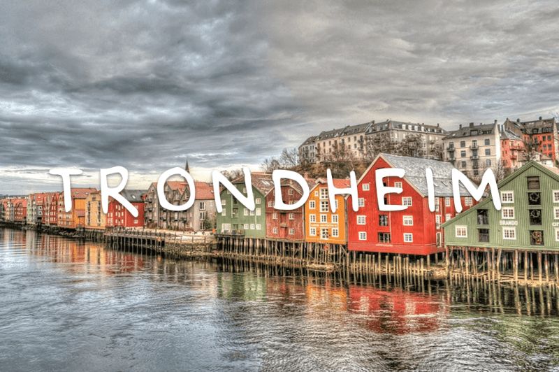
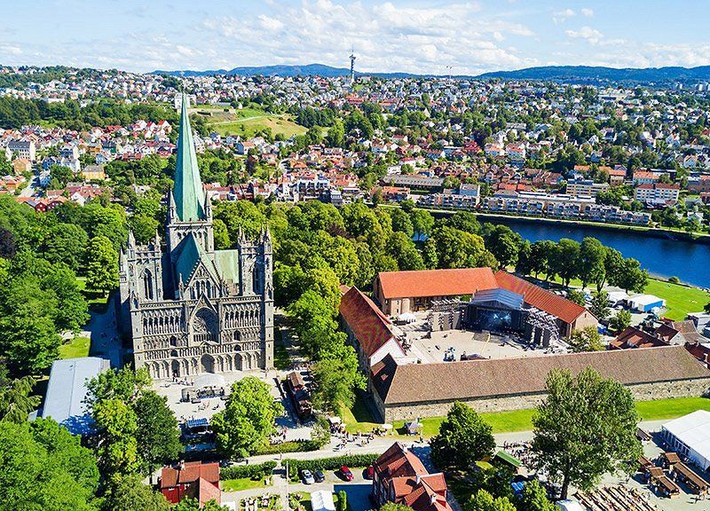
Trondheim, Noorwegen
Trondheim is a city in the Norwegian county of Trøndelag. With 198 219 inhabitants, it is the third largest city in Norway. Trondheim is located on the Trondheimfjord. The Hurtigruten ferry service docks in the city's harbour.
https://allesovernoorwegen.nl/...
In ancient times, Trondheim was the capital of Norway and the center of the Norwegian Vikings. The city is located in the county of Trøndelag on the Trondheimfjord and has almost 195,000 inhabitants. With this number of inhabitants, Trondheim is the third largest city in Norway and also the largest city in the middle of Norway!
Although it is often not a city that immediately rings a bell with everyone, it is definitely worth a visit during a tour of Norway. Trondheim is surrounded by impressive nature. It is also a real student city and has numerous cozy restaurants, cafes and museums. In short, a versatile destination with plenty to do!
63° 25' 49.9" N 10° 23' 42.2" E
63.4305149 10.3950528
• Head toward Apotekerveita on Kongens gate. Go for 296 m.
• Turn right onto Kjøpmannsgata. Go for 171 m.
• Turn right onto Erling Skakkes gate. Go for 391 m.
• Turn left onto Prinsens gate (6690). Go for 3.6 km.
• Continue on E6. Go for 2.9 km.
• Keep left onto E6 toward Oslo/E39. Go for 7.4 km.
• Take exit 30 toward Ålesund/Orkanger/707/715. Go for 549 m.
• Take the 2nd exit from roundabout onto E39 toward Ålesund/Orkanger. Go for 25.4 km.
• Turn sharp right onto Trondheimsveien toward Orkanger. Go for 226 m.
• Turn right toward Grensen. Go for 88 m.
• Continue on Grensen. Go for 220 m.
• Turn right onto Kaares gate. Go for 96 m.
• Turn left onto Sveligata. Go for 43 m.
• Arrive at Sveligata. Your destination is on the left.
☍
41,4 km
( 36 min.)
Route Alternatief naar ANDALSNES
TRONDHEIM E6 - OPPDAL road no:70 - SUNNDALSRORA road no: 62 then at NESSET to road no: 660 to road no: 64 - ANDALSNES
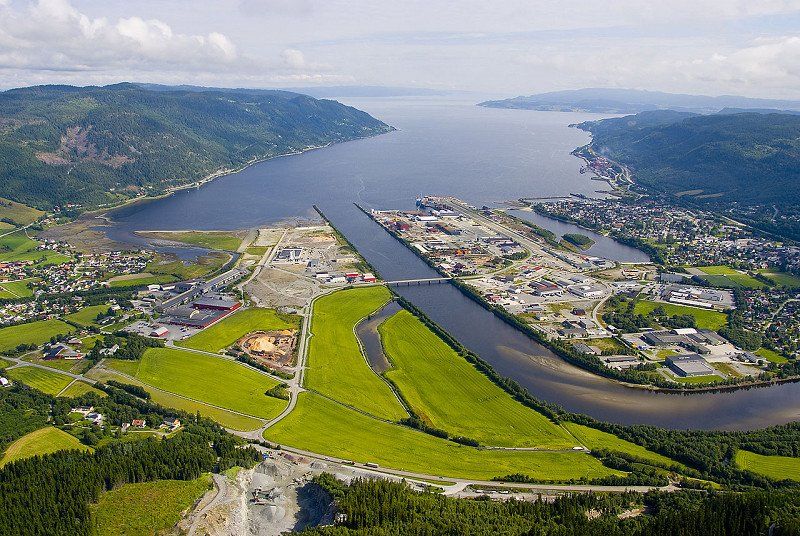
Orkanger, Noorwegen
Orkanger is a place in Orkland Municipality, Norway, in Trøndelag County. It is the capital of the municipality and has more than 8,000 inhabitants. Orkanger has an area of 6.25 km². In 2014, the place received city status. Between 1920 and 1963 Orkanger was an independent municipality.
63° 18' 44" N 9° 51' 12.7" E
63.3122326 9.8535236
• Head toward Kaares gate on Sveligata. Go for 43 m.
• Turn right onto Kaares gate. Go for 96 m.
• Turn left onto Grensen. Go for 308 m.
• Turn left onto Trondheimsveien. Go for 214 m.
• Turn right onto E39. Go for 1.3 km.
• Take the 1st exit from roundabout onto E39 toward Ålesund/710/714/Orkanger. Go for 120 m.
• Pass 3 roundabouts and continue on E39. Go for 2.9 km.
• Turn left onto E39 toward Ålesund/Frøya/714/Hitra. Go for 46.6 km.
• Turn left onto Vinjefjordsveien (E39) toward Ålesund/Kristiansund/Vinjeøra. Go for 43.4 km.
• Turn right onto Landvegen (E39) toward Ålesund/Kristiansund. Go for 7.3 km.
• Take the Halsa-Kanestraum Ferry. Stay on for 5.6 km.
• Head southwest on Straumsnesvegen (E39). Go for 8.8 km.
• Turn right onto Tingvollvegen (E39) toward Ålesund/Kristiansund. Go for 13.1 km.
• Take the 1st exit from roundabout onto 70 toward Kristiansund. Go for 16.4 km.
• Turn left onto Freikollveien (70). Go for 2.0 km.
• Pass 2 roundabouts and continue on Nordmørsveien (70). Go for 2.7 km.
• Turn right onto Wilhelm Dalls vei (70). Go for 1.7 km.
• Take the 2nd exit from roundabout onto Wilhelm Dalls vei (70). Go for 605 m.
• Continue on Langveien (70). Go for 1.2 km.
• Arrive at Langveien (70). Your destination is on the left.
☍
154,3 km
(2 hrs. 45 min.)
Day
Route
Road no: 65 then E39 then road no: 70 (direction KRISTIANSUND
Ferry: Halsa - Kanestraum Fjord1 AS
See app for departure times costs about € 13,-
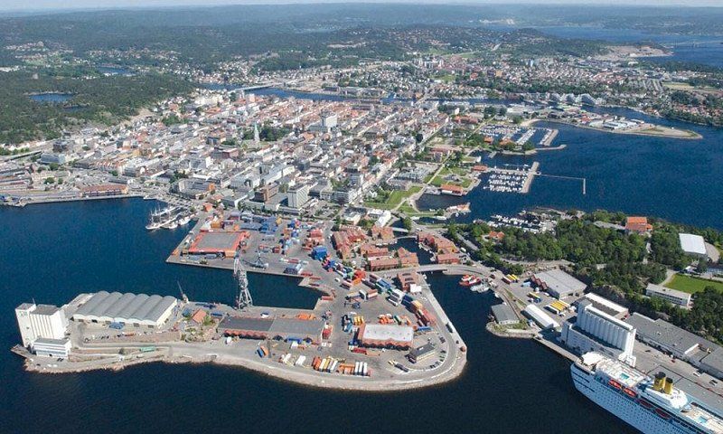
Kristiansund, Noorwegen
Kristiansund is a town and municipality in Møre og Romsdal county, Norway. The municipality, with 24,442 inhabitants, consists of the city of Kristiansund and the island of Frei. The town of Kristiansund is located on the coast of Nordmøre and consists of several islands; Kirkelandet, Nordlandet and Innlandet.
Walking in the center of Kristiansund
Kristiansund is a small town but offers a variety of cafes, shops and city facilities. In addition, there are various hiking options in or near the city. "The Ocean Path" is only 20 minutes away. on foot from the port.
The terrain is partly hilly, but there are bridges and steps on some parts of the trail to ensure good accessibility. There are fantastic views of the open sea and during the tour you will also come across historical sites such as bunkers from the Second World War. There are information boards about the special fauna in the area.
The tour is suitable for those with some hiking experience and is marked as moderately challenging. It has a total length of 4 km, consisting of part natural path and part dirt road.
63° 6' 37.2" N 7° 43' 41.1" E
63.1103346 7.7280790
• Head south on Langveien (70).
• Turn left onto Kaibakken (70). Go for 277 m.
• Turn left onto Vågeveien (70). Go for 221 m.
• Continue on Fosnagata (70). Go for 319 m.
• Continue on Hollendergata (539). Go for 74 m.
• Continue on Kranaveien (539). Go for 754 m.
• Take the 2nd exit from roundabout onto 64. Go for 281 m.
• Take the 3rd exit from roundabout onto Averøyveien (64). Go for 9.6 km.
• Take the 2nd exit from roundabout onto 64. Go for 19.2 km.
• Turn right onto 64. Go for 8.6 km.
• Arrive at 64.
☍
39,3 km
( 38 min.)
Route
Road no: 64
Ferry: Åfarnes - Sølsnes Fjord1 AS
See app for departure times € 10,-
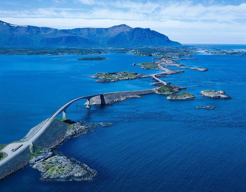
Atlanterhavsveien, 6494 Vevang, Noorwegen
The Atlantic Road is part of Fylkesvei 64 in Møre og Romsdal county in western Norway. The road connects the islands from Averøy to Vevang and Eide to the mainland to Kristiansund and Molde. Work began on August 1, 1983, until it opened on July 7, 1989.
Atlanterhavsveien, Vevang, Noorwegen
63° 0' 3.6" N 7° 17' 29.9" E
63.0010055 7.2916487
• Head toward Djupdalsvegen on 64. Go for 308 m.
• Turn left onto Vevangvegen (64). Go for 29.2 km.
• Pass 2 roundabouts and continue on Malmefjordvegen (64). Go for 9.6 km.
• Continue on Årødalsvegen. Go for 1.9 km.
• Take the 1st exit from roundabout onto Fannefjordsvegen (E39). Go for 893 m.
• Take the 1st exit from roundabout onto Fannefjordsvegen (E39) toward Ålesund/Molde. Go for 3.2 km.
• Take the 3rd exit from roundabout onto Fannestrandvegen (E39). Go for 492 m.
• Continue on Fannestrandvegen (537). Go for 638 m.
• Take the 3rd exit from roundabout onto Storgata (537). Go for 141 m.
• Turn left onto Rutebilholdeplassen. Go for 47 m.
• Arrive at Rutebilholdeplassen. Your destination is on the right.
☍
46,5 km
( 46 min.)
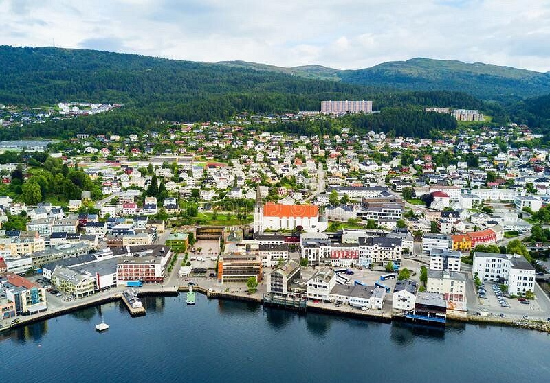
Molde, Noorwegen
Molde is the capital of the Norwegian province of Møre og Romsdal. The municipality had a population of 26,822 in January 2017. It is also the seat of the Bishop of Møre. In 2020 Molde was expanded with the former municipalities of Midsund and Nesset.
The city of roses, that is how the fjord city of Molde is also called. This Norwegian city is particularly popular with travelers and tourists who enjoy panoramic views. Molde is located on a large lake and near the ocean, on a slope at the Romsdalsfjord. Molde owes the nickname city of roses to its old houses, beautiful gardens and parks. You can find Molde in the Western fjord area of Norway, in the province of More og Romsdal. But what is there to do in this city and its surroundings? We have listed the to-do's for you for an unforgettable experience in Molde.
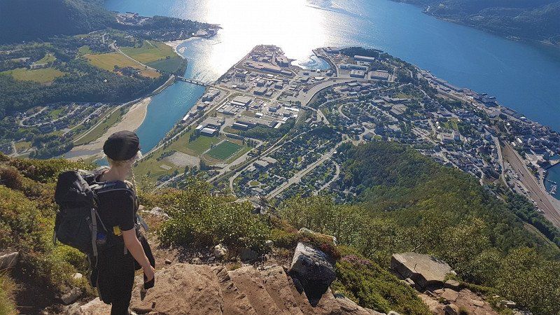
View over no less than 222 (!) mountain peaks from Varden
Around Molde you may find one of the most beautiful areas in Norway. This is due to the many mountains and beautifully situated fjords. Climb the Varden viewpoint, located about 400 meters above sea level. From this point you have a beautiful view over the city of Molde, the fjord and the various islands and mountains. On a clear day with good weather you seem to be able to see all 222 (!) mountain peaks with snow in the vicinity.
The walk to the Varden viewpoint is easy to do, both for novice and experienced hikers. You have beautiful views along the way! For the less fanatics among us it is also possible to drive up Mount Varden by car. And you can rent mountain bikes in the area and climb Varden by bike, highly recommended!
62° 44' 14" N 7° 9' 38.6" E
62.7372352 7.1607306
• Head south on Rutebilholdeplassen. Go for 88 m.
• Turn slightly right onto Apoteker Aas gate. Go for 42 m.
• Turn left onto Rektor Brinchmanns gate. Go for 30 m.
• Continue on Gotfred Lies plass. Go for 50 m.
• Turn right onto Strandgata (537). Go for 1.1 km.
• Take the 1st exit from roundabout onto Fannefjordsvegen (E39) toward Trondheim/Kristiansund. Go for 3.2 km.
• Take the 1st exit from roundabout onto Skålavegen (64) toward Åndalsnes/Bolsøya. Go for 17.4 km.
• Take the Sølsnes-Åfarnes Ferry. Stay on for 3.2 km.
• Head toward Langfjordsstranda on 64. Go for 360 m.
• Turn right onto Nordsidevegen (64). Go for 31.9 km.
• Take the 1st exit from roundabout onto Romsdalsvegen (64). Go for 614 m.
• Arrive at Romsdalsvegen (64). Your destination is on the right.
☍
57,9 km
(1 hrs. 27 min.)
Einde route Alternatief naar ANDALSNES
Åndalsnes, Noorwegen
Åndalsnes is a small town in Rauma Municipality in Møre og Romsdal County. Åndalsnes has approximately 3,000 inhabitants and is located at the mouth of the Rauma River that flows through the valley of Romsdal. The place can be reached via the railway line Raumabanen to Åndalsnes.
In addition to majestic mountains towering over deep valleys and verdant rivers, Åndalsnes is also home to gems such as Trollveggen, the Romsdalseggen ridge and the Geiranger-Trollstigen Norwegian Scenic Route.
The town of Åndalsnes in the northern part of Fjord Norway is known for its high mountains and long mountaineering tradition. That is why it is often referred to as the Alpine village by the fjord. The region has many mountains suitable for beginners, but there are also more challenging routes for experienced hikers and climbers. In winter, swap your hiking boots for skis!
For a different view of the landscape, you can walk along the via ferrata of Romsdalsstigen. Or walk along a route that was partly built by Nepalese Sherpas, towards the Rampestreken lookout point.
62° 34' 2.8" N 7° 41' 14" E
62.5674461 7.6872200
• Head toward Vollan on Romsdalsvegen (64). Go for 8 m.
• Turn left onto Jernbanegata. Go for 128 m.
• Turn left onto Storgata. Go for 628 m.
• Take the 1st exit from roundabout onto Nordsidevegen (64). Go for 637 m.
• Continue on Sørsidevegen (E136). Go for 43.3 km.
• Take the 2nd exit from roundabout onto Brastadstranda (E39) toward Ålesund. Go for 21.5 km.
• Turn left onto Giskemovegen (522). Go for 176 m.
• Continue on Valgermo (522). Go for 97 m.
• Continue on Giskemovegen (522). Go for 142 m.
• Continue on 522. Go for 43 m.
• Continue on Giskemovegen (522). Go for 1.0 km.
• Turn left onto Storfjordvegen (650). Go for 43.0 km.
• Turn left onto 63. Go for 35.1 km.
• Arrive at Isterdalsvegen (63). Your destination is on the right.
☍
145,9 km
(2 hrs. 16 min.)
Day
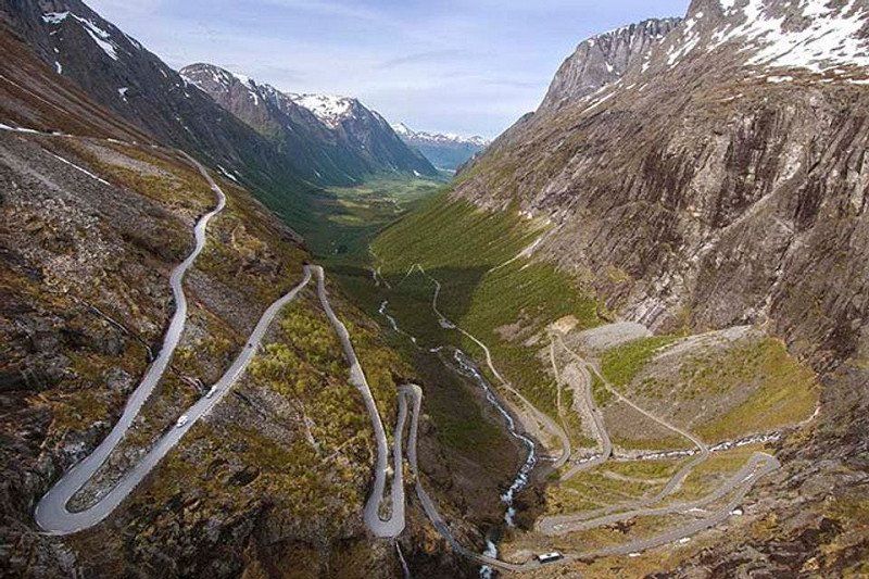
Trollstigen, Åndalsnes, Noorwegen
Experience the Trollstigen mountain road, one of the most visited attractions in Norway, at the UNESCO-protected Geirangerfjord.
The Trollstigen National Tourist Route is a 106 kilometer road through western Norway. Here, nature is at its best, with breathtaking views over mountain ridges, waterfalls, deep fjords and green valleys.
With a gradient of 9%, the Trollstigen mountain road consists of 11 hairpin bends. High mountains surround the road. The mountains all have stately names such as Kongen ('the King'), Dronningen ('the Queen') and Bishop ('the Bishop').
Trollstigen has been a magnet for tourists since the road opened in 1936. It is now possible, thanks to the skills of engineers and road builders, to drive up the steep mountain wall of Trollstigfoten to Stigerøra.
Ørnevegen (“the Eagle Road”) is the name of the steepest part of the road from Geiranger to Eidsdal on the highway Fv63. At Ørnesvingen you have a beautiful panoramic view of Geiranger; the waterfall 'De syv søstrene' (Seven Sisters), the mountain farm Knivsflå, and the most famous fjord in the world – Geirangerfjorden, which is also a UNESCO World Heritage Site.
Trollstigen, 6300 Åndalsnes, Noorwegen
62° 27' 17.7" N 7° 39' 57.5" E
62.4549066 7.6659830
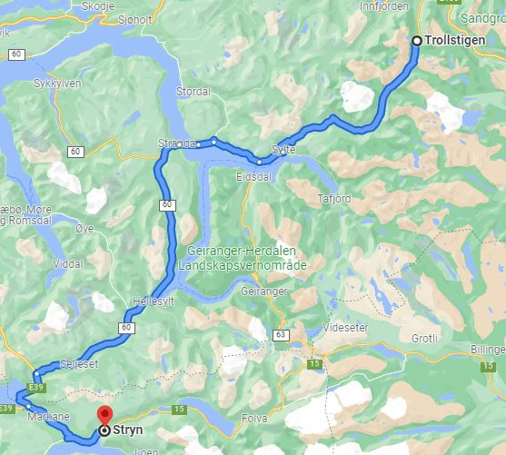
• Head southwest on Isterdalsvegen (63). Go for 35.1 km.
• Turn right onto 63. Go for 4.3 km.
• Continue on Lingestranda (650). Go for 8.4 km.
• Turn left onto Gravanesvegen (650). Go for 3.1 km.
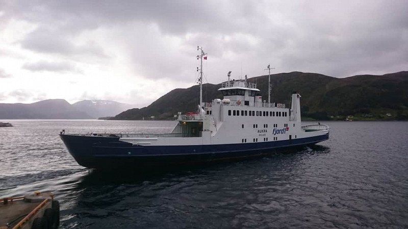
• Take the Liabygda-stranda Ferry. Stay on for 2.9 km.
• Head toward Bankgata on Sjøgata (60). Go for 1.6 km.
• Continue on Dalevegen (60). Go for 52.0 km.
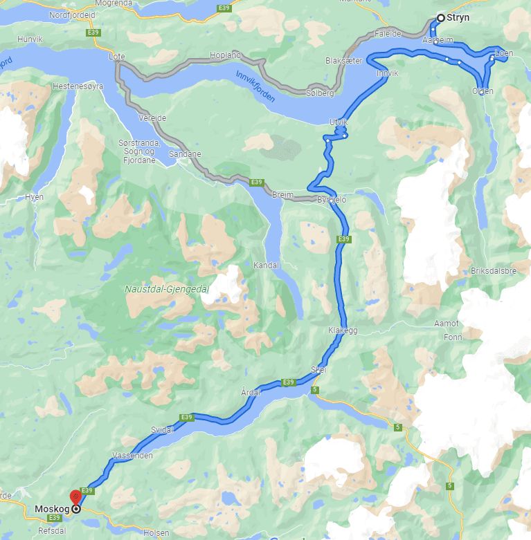
• Turn left onto E39 toward Bergen/Stryn/60. Go for 8.3 km.
• Turn left onto Nordfjordvegen (15) toward Stryn. Go for 15.8 km.
• Take the 1st exit from roundabout onto Visnesvegen (60) toward E39/Byrkjelo/Førde. Go for 57.4 km.
• Turn left onto Breimsvegen (E39). Go for 19.9 km.
• Take the 2nd exit from roundabout onto 5 toward Sogndal/Fjærland. Go for 61.1 km.
• Take the 3rd exit from roundabout onto Gravensteinsgata (5) toward E16/Lærdal/55/Lom. Go for 133 m.
• Pass 3 roundabouts and continue on 5. Go for 17.8 km.
• Turn left onto 5. Go for 60 m.
• Take the Mannheller-Fodnes Ferry. Stay on for 3.1 km.
• Head east on 5. Go for 8.8 km.
• Take the 2nd exit from roundabout onto Fodnesvegen (5) toward E16. Go for 227 m.
• Take the 2nd exit from roundabout onto 5 toward E16/Oslo/Bergen/Aurland. Go for 6.8 km.
• Take the 1st exit from roundabout onto E16 toward Bergen/Aurland. Go for 25.1 km.
• Take the 2nd exit from roundabout onto E16 toward Bergen/Voss. Go for 27.8 km.
• Turn right onto Gudvangatunnelen (5623). Go for 142 m.
• Arrive at Gudvangatunnelen (5623). Your destination is on the right.
☍
359,9 km
(6 hrs. 33 min.)
Route
Distance is not correct due to mountain pass route is shorter.
Day
Route
Ferry to GUDVANGEN
crossing: Stranda-Liabygda
https://www.fjord1.no/Ruteover...
Zia app for departure times € 9,-
Gudvangen, Noorwegen
Gudvangen is a village in Aurland Municipality in Sogn og Fjordane County in Norway. It is located by the Nærøyfjord, a tributary of the Sognefjord, and is a popular holiday destination. Close by is Stalheim. There is a ferry connection between Gudvangen - Kaupanger to Lærdal.
Kjelfossen Waterfall
From the quay in the center and from the main road you can see one of the highest waterfalls in Norway. With a height of 755 meters, the Kjelfossen is even one of the top twenty highest waterfalls in the world. In the months of June and July, this waterfall is at its most powerful, because of the large amount of melt water from the mountains. If you visit it at the end of the day, you will see how the waterfall colors beautifully in the setting sun. From the top of the mountain Stalheimskleiva the view of the Kjelfossen waterfall is also very good, although from a distance. In addition to a view of this waterfall, you can also see the Stalheimsfossen and Sivlefossen waterfalls.
Kjelfossen Waterfall, Gudvangen
Viking village Njardarheimr
On the outskirts of Gudvangen is the lively Viking village of Njardarheimr. The village of Gudvangen was even bigger in the time of the Vikings than it is today. Become a Viking and participate in the authentic activities in the village. The Viking Experience is a guided tour through the village. Hear the history stories about the Vikings and learn about their travels, boats and life.
Viking village Njardarheimr, Gudvangen
(equipped with SERVICE PLACE CAMPER)
Næroyfjord
Another highlight is a visit to the Nærøyfjord. It is not for nothing that it is on the UNESCO World Heritage List, because it is the narrowest fjord in the world. At its narrowest point, this fjord is only 250 meters wide. A fun way to see this fjord is to take a sightseeing cruise from Gudvangen, which takes you between the spectacular mountains. You have a view of waterfalls that flow along the high and snow-capped mountain peaks. You also have a view of colorful villages that lie on the banks, hidden among the greenery. A boat trip takes about two to four hours.
Nærøyfjord, Gudvangen
kayaking
Experience the fairytale fjord landscape from a kayak and sail the waters of Nærøyfjord. A special experience guaranteed. Paddle past the beautiful waterfalls, small settlements and farms. You will reach places that can only be reached by kayak. You cannot rent a single kayak unless you are very experienced, but a double kayak for two is possible. Of course you can also go on an excursion accompanied by a guide.
60° 52' 43.4" N 6° 50' 19.6" E
60.8787189 6.8387736
• Head south on Gudvangatunnelen (5623). Go for 142 m.
• Turn left onto E16. Go for 27.8 km.
• Take the 2nd exit from roundabout onto E16 toward Oslo/Lærdal. Go for 25.1 km.
• Take the 2nd exit from roundabout onto 5 toward Sogndal/Lærdal. Go for 6.8 km.
• Take the 1st exit from roundabout onto Fodnesvegen (5) toward Sogndal/Årdal. Go for 208 m.
• Take the 2nd exit from roundabout onto Grandavegen (5) toward Sogndal/Årdal. Go for 8.5 km.
• Keep left onto 5. Go for 366 m.
• Take the Fodnes-Mannheller Ferry. Stay on for 3.1 km.
• Head north on 5. Go for 16.5 km.
• Pass 3 roundabouts and continue on Gravensteinsgata (5). Go for 1.4 km.
• Take the 1st exit from roundabout onto 5 toward Førde/Skei. Go for 61.0 km.
• Take the 1st exit from roundabout onto Jølstravegen (E39) toward Ålesund/Nordfjordeid. Go for 19.9 km.
• Turn right onto Fjellvegen (60) toward Stryn. Go for 57.4 km.
• Take the 1st exit from roundabout onto Tonningsgata (15). Go for 340 m.
• Arrive at Tonningsgata (15).
☍
228,5 km
(3 hrs. 49 min.)
Route
from ferry road nr 60 and then the 15 to STRYN
Stryn, Noorwegen
Stryn is a municipality and ski resort located on the Nordfjord in the Norwegian county of Vestland. The municipality had 7,218 inhabitants in January 2017. The municipality consists of the main town of Stryn and the villages of Loen, Olden, Innvik, Utvik, Nordsida and Markane on both sides of the fjord.
Briksdal Glacier (Briksdalbreen), Stryn
Nestled between thundering waterfalls and high cliffs along a small glacial lake, Briksdal Glacier (Briksdalbreen) represents an easily accessible arm of continental Europe's largest pancake glacier. Explore the lush valley on foot, taking the trails leading from the local mountain refuge and following streams of melting ice that flow to the sea. Take a "troll buggy" trip to the glacier if ice conditions and weather permit. Otherwise, opt for a guided glacier safari in a rafting boat on the lake. Tourist-friendly facilities include a restaurant and the largest gift shop in the area. Beware of roadblocks - glacier movement and the threat of avalanches can make roads dangerous. Use our Stryn trip planner to visit Briksdal Glacier (Briksdalbreen) on your trip to Strynen, and learn what else travelers and our writers recommend seeing nearby.
61° 54' 16" N 6° 43' 22.5" E
61.9044329 6.7229249
• Head toward Tinggata on Tonningsgata (15). Go for 330 m.
• Take the 2nd exit from roundabout onto Visnesvegen (60) toward E39/Førde/Byrkjelo/Måløy. Go for 57.4 km.
• Turn left onto Breimsvegen (E39). Go for 19.9 km.
• Take the 1st exit from roundabout onto Jølstravegen (E39) toward Bergen/Førde. Go for 32.2 km.
• Turn left onto 613 toward Balestrand. Go for 3.1 km.
• Turn right onto Nydalsvegen. Go for 5.1 km.
• Turn right onto Nyddalen. Go for 388 m.
• Arrive at your destination.
☍
118,4 km
(1 hrs. 47 min.)
Moskog, Førde, Noorwegen
Huldefossen is a waterfall in the basin of the river Gaular and located near Mo, part of the municipality of Sunnfjord in the Norwegian county of Vestland. The Huldefossen is sometimes also called the Huldrefossen and is located in the river after which the waterfall is named, the Hulda.
Huldefossen is located in Mo, off the E39, about 10 km from Førde. There are signs to the parking lot. It is about 500 meters walk over a wooden bridge and along the river. The waterfall has a fall of approximately 90 meters in length and is one of the most photographed waterfalls in Fjord Norway.
Huldefossen, 6819 Førde, Norway (address)
6819 Førde, Noorwegen
61° 24' 39.4" N 6° 7' 36.5" E
61.4109520 6.1268142
• Head toward Nydalsvegen. Go for 300 m.
• Continue on Nyddalen. Go for 88 m.
• Turn left onto Nydalsvegen. Go for 123 m.
• Continue on Nydalsvegen. Go for 5.0 km.
• Turn right onto 613. Go for 79.5 km.
• Take the 1st exit from Norafjordvegen roundabout onto Lunde (55) toward Vadheim/Balestrand. Go for 9.3 km.
• Arrive at Balestrandvegen (55). Your destination is on the left.
☍
94,4 km
(1 hrs. 31 min.)
Route
Road nr : Fv13 to BALESTRAND narrow roads and hairpin bends. Beautiful route
Balestrand, Noorwegen
Balestrand is a former municipality in the Norwegian county of Sogn og Fjordane, on the Sognefjord. The municipality had 1,288 inhabitants in January 2017. The Esefjord empties into the Sognefjord on the east side of Balestrand. The main sources of income were agriculture and tourism.
61° 12' 15.7" N 6° 31' 34.5" E
61.2043670 6.5262627
• Head north on Balestrandvegen (55). Go for 734 m.
• Turn right onto Kaivegen (55) toward Sentrum/Ferge Fjærlandsfjorden. Go for 329 m.
• Continue on 55. Go for 14 m.
• Continue on Holmen (55). Go for 86 m.
• Continue on 55. Go for 37 m.
• Take the Balestrand-Dragsvik Ferry. Stay on for 2.1 km.
• Take the Dragsvik Kai-Hella Ferry. Stay on for 1.8 km.
• Take the Hella-Vangsnes Ferry. Stay on for 4.2 km.
• Head south on 13. Go for 33 m.
• Turn left onto Vangsnesvegen (13). Go for 24 m.
• Arrive at Vangsnesvegen (13). Your destination is on the left.
☍
9,4 km
( 44 min.)
Day
Route nog uitzoeken
Dragsvik - Vangsness ferry crossing
https://www.rome2rio.com/s/Van...
https://autopassferje.no/prise...
€60
Vangsnes, Noorwegen
Vangsnes is a village of Vik Municipality in Vestland County in Norway. In the village stands the 22 meter tall statue Fridtjof den frøkne. It represents the main character of the Old Norse Frithjofssaga.
61° 10' 29.6" N 6° 38' 15.6" E
61.1748940 6.6376674
• Head west on Vangsnesvegen (13). Go for 58.1 km.
• Take the 1st exit from roundabout onto Vinjadalen (E16) toward Bergen/13/Voss. Go for 16.9 km.
• Pass 4 roundabouts and continue on Strandavegen (E16). Go for 2.6 km.
• Turn right onto Strandavegen (E16). Go for 1.2 km.
• Continue on Vangsgata (E16). Go for 49 m.
• Turn right onto Vangsgata. Go for 57 m.
• Turn right onto Bonangergata. Go for 31 m.
• Turn left onto Bonangergata. Go for 33 m.
• Arrive at Bonangergata. Your destination is on the right.
☍
78,9 km
(1 hrs. 14 min.)
Voss, Noorwegen
Vossevangen is a place in the municipality of Voss herad in the Norwegian province of Vestland. Vossevangen has 5674 inhabitants and has an area of 4.51 km². Voss van de Bergensbanen is located in Vossevangen.
Are you ready for action-packed adventures, the extreme environment and Norwegian culinary specialties in Voss, the adrenaline capital of Europe?
You are most welcome in the village of Voss with its snow-capped mountains, green valleys, wild rivers, rugged waterfalls and calm lakes. About 15,000 people live there and Voss is strategically located between Bergen, the Sognefjord and the Hardangerfjord.
Are you an adrenaline junkie? Then Voss is the place to be! Take on the rapids of one of the best rivers in Europe for rafting, jump out of a plane (with a parachute of course) or soar above the landscape with a paraglider.
The two ski areas, Myrkdalen Fjellandsby and Voss Resort, turn Voss into one of Fjord Norway's top ski destinations in winter. The rest of the year, the varied landscape is ideal for hiking and cycling, or how about mountain climbing or kayaking? There is always something to experience, also for you!
Or you can hop on the Voss gondola that takes you from the train station to the mountains in nine minutes!
On top of Hangurstoppen mountain, 820 meters above sea level, is the largest restaurant in Voss.
The region carries 'Tasty food!' literally and figuratively high on the agenda. Even Gordon Ramsay has visited the region to sample the traditional regional dish, smalahove (sheep's head). Farm Smalahovetunet prepares this specialty especially for you. There is also cured meat, salted and dried mutton ribs and porridge with sour cream on the menu.
This village also hosts a number of well-known events, such as Vossa Jazz and Ekstremsportveko, the largest extreme sports festival in the world!
Detailed travel information can be found on the official Voss website.
Vossevangen, Noorwegen
60° 37' 46.4" N 6° 25' 19.7" E
60.6295624 6.4221512
• Head east on Bonangergata. Go for 33 m.
• Turn right onto Bonangergata. Go for 31 m.
• Turn left onto Vangsgata. Go for 42 m.
• Turn right toward Sverresplassen/E16. Go for 59 m.
• Turn left onto Uttrågata (13) toward Gjernes. Go for 1.8 km.
• Turn right onto Hardangervegen (13). Go for 30.2 km.
• Take the 1st exit from roundabout onto Vallaviktunnelen (13). Go for 3.3 km.
• Take the 2nd exit from Butunnelen roundabout onto Butunnelen (13). Go for 13.6 km.
• Arrive at Kinsarvikvegen (13). Your destination is on the left.
☍
49,1 km
( 43 min.)
Kinsarvik, Noorwegen
Kinsarvik is a place in the Norwegian municipality of Ullensvang, province of Vestland. Kinsarvik has 453 inhabitants and has an area of 0.71 km². Kinsarvik was an independent municipality in Hordaland between 1913 and 1964. Kinsarvik is located on the Sørfjord, a tributary of the Hardangerfjord.
60° 22' 32.4" N 6° 43' 20.9" E
60.3756766 6.7224791
• Head west on Kinsarvikvegen (13). Go for 40.8 km.
• Arrive at Eitrheimsvegen (13). Your destination is on the left.
☍
40,8 km
( 39 min.)
Odda, Noorwegen
Odda is a former municipality in the Norwegian province of Hordaland with 7025 inhabitants. Odda was located on the Sørfjord, a tributary of the Hardangerfjord. On January 1, 2020, Odda was incorporated together with the municipality of Jondal into the municipality of Ullensvang which was incorporated into the province of Vestland formed on the same day.
60° 4' 9" N 6° 32' 46.4" E
60.0691756 6.5462350
• Head west on Eitrheimsvegen (13). Go for 291 m.
• Take the 2nd exit from roundabout onto Røldalsvegen (13). Go for 17.7 km.
• Turn left onto E134 toward Haukeli/Rødal. Go for 78.1 km.
• Turn left onto Hauganvegen. Go for 16 m.
• Turn right onto Gugardsvegen. Go for 30 m.
• Arrive at Gugardsvegen. Your destination is on the right.
☍
96,2 km
(1 hrs. 24 min.)
Day
Haukeligrend, Noorwegen
Haukeligrend is a place belonging to the municipality of Vinje in the county of Vestfold og Telemark in southern Norway. It is located along the E134 at the point where Riksvei 9 ends.
59° 44' 5.6" N 7° 33' 7.9" E
59.7349011 7.5521979
• Head toward Hauganvegen on Gugardsvegen. Go for 30 m.
• Turn left onto Hauganvegen. Go for 16 m.
• Continue on 9. Go for 26.6 km.
• Take the 2nd exit from roundabout onto Setesdalsvegen (9). Go for 891 m.
• Arrive at Setesdalsvegen (9). Your destination is on the right.
☍
27,5 km
( 25 min.)
Hovden, Noorwegen
59° 33' 37.6" N 7° 21' 24.1" E
59.5604493 7.3567043
• Head toward Skisentervegen on Setesdalsvegen (9). Go for 54.0 km.
• Pass 3 roundabouts and continue on Setesdalsvegen (9). Go for 93.1 km.
• Turn right onto Verksvegen. Go for 49 m.
• Turn left onto Verksvegen. Go for 260 m.
• Arrive at Verksvegen. Your destination is on the left.
☍
147,3 km
(1 hrs. 59 min.)
Evje, Noorwegen
58° 34' 55" N 7° 47' 39.4" E
58.5819568 7.7942706
• Head toward Malmvegen on Verksvegen. Go for 260 m.
• Turn right onto Verksvegen. Go for 49 m.
• Turn left onto Setesdalsvegen (9). Go for 1.1 km.
• Turn right onto Arendalsvegen (42). Go for 22.3 km.
• Turn right onto Vegusdalveien (405) toward Vennesla/Iveland/Engesland. Go for 4.9 km.
• Turn left onto Vegusdalveien (406). Go for 17.8 km.
• Turn right onto Herefossveien (41). Go for 11.0 km.
• Turn left onto Birkelandsveien (402). Go for 9.5 km.
• Pass 2 roundabouts and continue on Birkelandsveien (402). Go for 954 m.
• Take the 2nd exit from roundabout onto E18 toward Oslo. Go for 20.1 km.
• Take ramp toward Grimstad. Go for 104 m.
• Continue on Arendalsveien (420). Go for 1.4 km.
• Turn right onto Levermyrveien. Go for 42 m.
• Turn right onto Levermyrveien. Go for 158 m.
• Turn right onto Furuheia. Go for 105 m.
• Arrive at Furuheia. Your destination is on the right.
☍
89,7 km
(1 hrs. 21 min.)
Day
Grimstad, Noorwegen
58° 20' 40.9" N 8° 35' 41.5" E
58.3447019 8.5948668
• Head toward Furuli terrasse on Furuheia. Go for 204 m.
• Turn left onto Furuliveien. Go for 496 m.
• Continue on Frivoldveien. Go for 114 m.
• Take the 2nd exit from roundabout onto Frivoldveien. Go for 378 m.
• Turn right onto Storgaten (3624). Go for 169 m.
• Continue on E18. Go for 153 m.
• Turn left and take ramp onto E18 toward Kristiansand. Go for 45.6 km.
• Take ramp toward Evje/Terminalen/E39/Danmark/Terminal. Go for 174 m.
• Take the 2nd exit from roundabout onto Vesterveien toward Stavanger/E39/Danmark. Go for 373 m.
• Take the 3rd exit from roundabout onto Vesterveien toward E39/Danmark. Go for 219 m.
• Turn sharp right. Go for 447 m.
• Take the Kristiansand-Hirtshals Ferry. Stay on for 139 km.
• Head southeast on E39. Go for 1.1 km.
• Turn left onto Willemoesvej toward Østhavn. Go for 160 m.
• Turn left onto Østergade. Go for 500 m.
• Take the 3rd exit from roundabout onto Skovvejen. Go for 114 m.
• Turn right onto Lillehedenvej. Go for 268 m.
• Arrive at Lillehedenvej. Your destination is on the left.
☍
189,3 km
(4 hrs. 42 min.)
Day
Hirtshals, Denemarken
9850 Hirtshals, Denemarken
57° 35' 13" N 9° 58' 0.6" E
57.5869530 9.9668379
• Head west on Lillehedenvej. Go for 93 m.
• Turn left onto Margrethevej. Go for 759 m.
• Take the 3rd exit from roundabout onto Søndergade. Go for 1.1 km.
• Turn left onto Dalsagervej (55) toward Hjørring/E39/Skagen/579/Tversted. Go for 82 m.
• Take the 2nd exit from roundabout onto Aalborgvej (E39) toward Aalborg/Skagen/597. Go for 2.2 km.
• Take the 2nd exit from roundabout onto E39 (Hirtshalsmotorvejen) toward Aalborg. Go for 57.0 km.
• Continue on Vendsyssel. Go for 196 m.
• Continue on E45 (Vendsyssel). Go for 212 km.
• Continue on E45 (Sønderjyske Motorvej) toward Flensborg. Go for 83.2 km.
• Continue on A7. Go for 156 km.
• Keep left onto A7. Go for 14.7 km.
• Keep right onto A261 (Autobahndreieck Hamburg-Südwest) toward Bremen/Tötensen. Go for 9.0 km.
• Take exit 4 toward Osnabrück/Bremen/Rade onto A1. Go for 202 km.
• Take exit 72 toward Amsterdam/Rheine onto A30. Go for 65.1 km.
• Continue on A1. Go for 25.8 km.
• Take the exit toward Amsterdam/Deventer onto A1. Go for 47.2 km.
• Take exit 21 toward Arnhem onto A50. Go for 24.1 km.
• Take the left exit toward Rotterdam/Eindhoven/Nijmegen/Utrecht onto A12/A50. Go for 7.3 km.
• Take the exit toward Rotterdam/Eindhoven/Nijmegen onto A50. Go for 39.2 km.
• Take the exit toward Oss/'s-Hertogenbosch onto A59 (Knooppunt Paalgraven). Go for 17.4 km.
• Take the left exit toward Ring-Zuid/Eindhoven/Tilburg onto A2 (Ring 's-Hertogenbosch). Go for 11.3 km.
• Take exit 25 toward Boxtel-Noord/Esch. Go for 434 m.
• Turn left onto Bosscheweg. Go for 918 m.
• Turn right onto Baandervrouwenlaan. Go for 374 m.
• Turn right onto Halderheiweg. Go for 486 m.
• Arrive at Halderheiweg. Your destination is on the left.
☍
977,7 km
(9 hrs. 2 min.)
Day
Boxtel, Nederland
51° 36' 5.2" N 5° 18' 43.8" E
51.6014370 5.3121773