Unfortunately, we don't support your browser (Internet Explorer) anymore, some functionalities could not work. Click here to get information on how to upgrade your browser.

Travelogue


Route
Show newest first-
Send-To-Car (Zenec)
-
46.8928 8.628
-
46° 53' 34.3" N 8° 37' 40.8" E
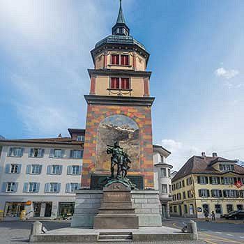
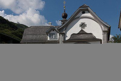
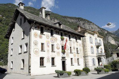
Laut dem Stück von Friedrich Schiller ist Altdorf der Schauplatz des Apfelschusses von Wilhelm Tell. Nachdem dieser sich weigerte, Gesslers Hut auf der Stange zu grüssen, wurde er von Gessler dazu gezwungen, einen Apfel vom Kopf seines Sohnes zu schiessen. Dies soll sich auf dem Altdorfer Marktplatz ereignet haben, wo deswegen 1895 am Fusse eines alten Turms (Türmli) das Telldenkmal, eine Bronzestatue des Zürchers Richard Kissling, die Tell und seinen Sohn zeigt, errichtet wurde. 1899 wurde nahe dem Ort ein Theater (Tellspielhaus) eröffnet mit dem alleinigen Zweck, Friedrich Schillers Schauspiel Wilhelm Tell aufzuführen.
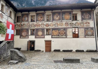
Das Haus für Kunst Uri wurde im Jahr 2004 eröffnet. Es bietet auf drei Geschossen, in einer Erweiterungshalle und in einem grosszügigen Hof Raum für zeitgenössische Ausstellungen. Neben dem Ausstellungsprogramm mit überregionaler Ausstrahlung wird das Werk des Urner Künstlers Heinrich Danioth (1896–1953) besonders gewürdigt.
Kirchenschatzmuseum St. Martin: Seit 1982 ist der kostbare Kirchenschatz der Pfarrei St. Martin Altdorf im Pfarreizentrum öffentlich zugänglich.
Türmli Altdorf: Das Türmli ist ein mittelalterlicher Wohnturm und wurde im frühen 16. Jahrhundert zu einem Rathaus-Campanile umfunktioniert. Beim Türmli war auch der öffentliche Pranger aufgestellt. 1895 wurde vor dem Türmli das Telldenkmal von Richard Kissling eingeweiht. Das Türmli ist seit 2011 öffentlich zugänglich und enthält eine kleine Ausstellung.
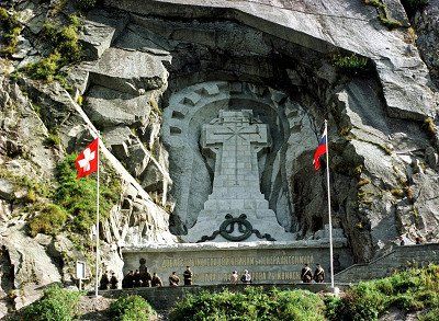
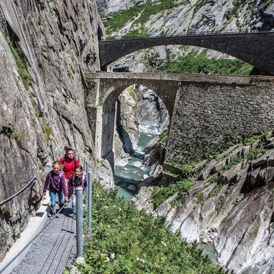
Das Suworow-Denkmal ist ein in den Fels gehauenes 12 Meter hohes Gedenkkreuz in der Schöllenenschlucht bei der Teufelsbrücke. Es erinnert seit September 1899 an die Kampfhandlungen, die am 25. September 1799 im Rahmen des Zweiten Koalitionskrieges in dieser Gegend zwischen napoleonischen Truppen unter Claude-Jacques Lecourbe (1758–1815) und von General Alexander Wassiljewitsch Suworow befehligten russischen Truppen stattfanden.
Das Denkmal wurde von Fürst Sergei Galitzin initiiert, der das Werk auf eigene Kosten errichten lassen wollte. Im Jahr 1883 stimmte der Schweizer Bundesrat dem Ansinnen zu, erklärte aber Gestaltung und Inschrift als bewilligungspflichtig. Auch dies geschah nur, nachdem der Zweck der Stätte abgeändert worden war und nun zu Ehren der gefallenen Soldaten errichtet werden sollte. Der Bau eines Denkmals für einen fremdländischen General wäre aus Gründen der Neutralität nicht möglich gewesen. Die Kantonsregierung konnte sich zur Gänze nicht mit einem Denkmal zur «Invasion fremder Mächte» anfreunden.
Die Errichtung wurde vom Besitzer des Landes, dem Korporationsrat Urseren, genehmigt, wobei das Gelände laut dem Entscheid des Korporationsrats vom 13. Oktober 1893 unentgeltlich dem Russischen Kaiserreich abgetreten wurde. Die Bauarbeiten mit Unterstützung des russischen Aussenministeriums dauerten annähernd drei Jahre, dies zum Missfallen der Landesregierung, die gemäss Ratsprotokoll eine «Erinnerungstafel an die Opfer», ein Totenmal, bewilligt hatte. Bereits zuvor war ein heroisierender Entwurf abgelehnt worden.
Das 563 m² grosse Areal (449 m² Fels und 114 m² Zugangsweg) wird von der Gemeinde Andermatt unterhalten, Eigentümer ist der russische Staat in Form der russischen Botschaft in Bern. Die betreffende Parzelle Nr. 725 des Grundbuchs Andermatt ist dem schweizerischen Recht uneingeschränkt unterworfen und Bestandteil des schweizerischen Territoriums.
-
Send-To-Car (Zenec)
-
46.6319 8.5919
-
46° 37' 55" N 8° 35' 31" E
www.andermatt.ch/de/region-ent...
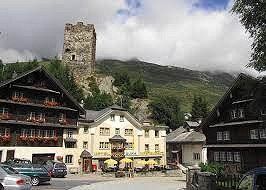
Das markanteste Bauwerk ist der Turm der Herren von Hospental, erbaut in der ersten Hälfte des 13. Jahrhunderts. Er diente als Wohnturm, ist aber seit dem 15. Jahrhundert nicht mehr bewohnt. Sehenswert ist auch die barocke Pfarrkirche Maria Himmelfahrt (1706–1708) mit überaus prunkvollen Altären. Im Dorfkern stehen zahlreiche in Blockbauweise erstellte Holzhäuser, die nach dem Dorfbrand von 1669 entstanden. Am Dorfrand stehen die Kapelle und das Pfrundhaus St. Karl. Die barocke Kapelle aus dem Jahr 1721 wurde 1907 in neubarockem Stil renoviert. Die Kapelle St. Nikolaus im Weiler Zumdorf stammt ursprünglich aus dem Jahr 1591 und wurde 1758 im Stil des Barock erneuert.
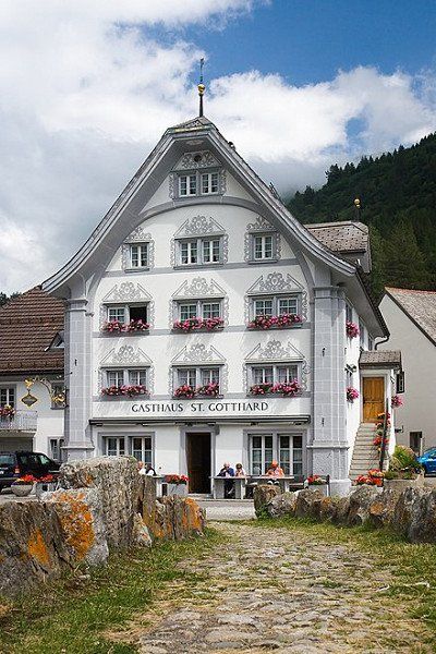
Im Hotel Gotthard stieg General Suvarow ab. Die Küche ist empfehlenswert.
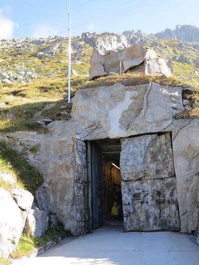
Das Festungsgebiet Gotthard gehörte zusammen mit den Festungen Saint-Maurice und Sargans zu den drei grossen Festungsräumen der Schweizer Armee im Reduit-Verteidigungsdispositiv des Zweiten Weltkriegs und fortdauernd während des Kalten Krieges. Nach Kriegsende wurden die alten Festungen als Kampfanlagen aufgehoben und teilweise als Truppenunterkünfte verwendet. Während des Kalten Krieges wurden die neuen Festungen unterhalten, modernisiert und neuen Entwicklungen (neue Waffensysteme, AC-Schutz usw.) angepasst. Zusätzlich wurden moderne Unterstände (Typ U4, U12) für die Truppen gebaut.
Mit den neuen Truppenordnungen (TO 47 und 51) kam die 9. Division definitiv in das neu gegliederte 3. Armeekorps. 1947 entstand um die Gotthardfestung mit der Reduitbrigade 23 «Gotthardbrigade» (Stab Reduitbrigade 23, Festungsartillerieregiment 23, Infanterieregiment 65, Territorialregiment 81) wieder ein selbständiger Verband. 1951 (TO 51) wurde sie zur Festungsbrigade 23 umbenannt. Mit der Armee 61 wurde die 9. Division zur Gebirgsdivision 9 (Geb Div 9) unter dem umbenannten Gebirgsarmeekorps 3. In der zweisprachigen Division leisteten Wehrmänner aus 14 Kantonen ihren Dienst. Mit dem Rüstungsprogramm 1993 wurden acht BISON-Geschützbunker auf die Festungsräume St. Maurice, Gotthard und Sargans verteilt. Jede Batterie hatte zwei Monoblockbunker mit je zwei 15,5 cm Festungskanonen 89 L52 BISON. Die Bison-Batterien konnten dank ihrer Feuerkraft und mit ihren selbstzielsuchenden Granaten den Verlust der aufgehobenen Festungen mehr als ausgleichen.
Am 25. August 2012 wurde in der einst streng geheimen Festung Sasso da Pigna das Museum Sasso San Gottardo eröffnet. Der Name stammt von der Felsterrasse Sasso di San Gottardo.2019, bereits nach der siebten vollen Saison, hatte das Museum über 200.000 Besucher.
Tief im Innern des Berges verbergen sich die kilometerlangen Stollen und Kavernen der einst streng geheimen Gotthardfestung. Es gibt zwei Sektoren in der unterirdischen Anlage: den Sektor 'Ausstellungen' und den Sektor 'historische Festung'.
Sektor Ausstellungen
- Caverna Grande mit der Bildmaschine 'Reduit' von Tullio Zanovello
- Mythos Gotthard
- Goethe am Gotthard (ab Sommer 2022)
- Riesenkristalle
- Wunderkammer
- Energiekaverne der ehemaligen Festung
Bildmaschine 'Reduit'
Es handelt sich um die grösste jemals von Tullio Zanovello erbaute Bildmaschine. Während der rund dreissigminütigen Performance der Bildmaschine erzählen sich bewegende Gemälde von den alten Sagen und Mythen des Gotthards. Der multitalentierte Kunstmaler aus Zürich hat nicht nur die zahllosen Bilder gemalt und die grosse Statue der Helvetia gebaut, sondern die Maschine auch selbst konstruiert, die Musik dazu komponiert und den Chortext geschrieben.[5]
Riesenkristalle / Wunderkammer
1,5 Tonnen reine, bis meterhohe Bergkristalle, gefunden 2008 von Franz von Arx und Elio Müller. In der Wunderkammer wird gezeigt, wie in der Schweiz auch heute noch Schmuck mit Quarzkristallen aus den Bergkantonen hergestellt wird. Diese Ausstellung hat Sasso San Gottardo gemeinsam mit dem Schweizer Label ELVETIA - Schmuck und dem Urner Berufsstrahler Elio Müller realisiert.
Mythos Gotthard
In einem Ausstellungsraum werden die verschiedenen Phasen des Mythos Gotthard gezeigt: Von der Namensgebung über Goethes Gotthardmythos und damit verbunden mit der Tell-Sage bis zum Reduit von General Guisan, dessen Kernstück die Gotthardfestung war.
Goethe am Gotthard
Schweizweit erstmals wird im Sommer 2022 eine neue Dauerausstellung über Goethes Gotthardreisen eingerichtet. Die Vernissage findet am 2. und 3. Juli 2022 statt.
Energiekaverne
Im Sektor Ausstellungen befindet sich die Energiekaverne noch im Originalzustand. Hier wird gezeigt, wie mit Dieselgeneratoren Strom für den Eigenbedarf der Festung produziert wurde.
Metro del Sasso
Durch einen langen Verbindungsstollen führt der grosse Rundgang weiter zur Metro del Sasso. Der Schrägaufzug wurde 2012 für den Museumsbetrieb eingerichtet. Ursprünglich fuhr auf den Geleisen nur eine Munitionstransportbühne. Die Truppe nutzte die Treppe mit 475 Stufen, um die 80 Meter Höhendifferenz zu überwinden.
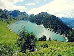
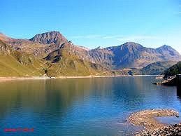
Der Lago Ritóm ist ein Speichersee im Pioratal (Val Piora), einem Seitental der Leventina in der Schweizer Gemeinde Quinto. Nördlich befindet sich der kleine Lago di Tom.
Der See ist glazialen Ursprungs und ist von 1917 bis 1920 zum Stausee für das Ritom-Kraftwerk der SBB erweitert worden. Die 170 Meter lange Schwergewichtsmauer wurde 1950 auf eine Höhe von 23 Meter und 309 Meter Länge gebracht. Aufgrund des porösen Untergrunds im oberen Bereich ist diese Höhe aber nicht komplett nutzbar.
Der See ist über Bergwanderwege, eine Fahrstrasse oder über die sehr steile Standseilbahn Ritom (max. 87,8 %) bequem zugänglich. Bei der Staumauer befindet sich auch eine Unterkunft.
Das Piora Tal ist auch sehr bekannt für seinen legendären Piora Käse, den Sie nicht verpassen dürfen! Auf einsamen und weiten Weiden grasen ab Juni die Kühe und diesen verdanken wir das herrliche Produkt. Die Alpe Piora umfasst das grösste Weidegebiet des Kantons Tessin. Auf 3500 Hektaren grasen ca. 300 Milchkühe und 200 Rinder. Ein Käse von Weltruf, sagen die Einheimischen stolz.
Es werden jährlich ca. 100-120 Tonnen produziert, die sofort zu den guten Adressen gelangen. Der stolze Preis von CHF 55.- fürs Kilo einjährigen Käse ist eine lohnende Investition und rundet jeden Ausflug ins Val Piora gelungen ab.
-
Send-To-Car (Zenec)
-
46.4019 8.8772
-
46° 24' 6.9" N 8° 52' 38" E
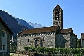
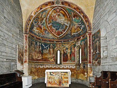
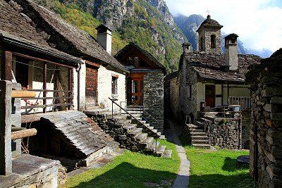
Das Dorf ist von Weinbergen und Kastanienwäldern umgeben. Der alte Dorfkern, der im Inventar schützenswerten Ortsbilder der Schweiz (ISOS) als schützenswertes Ortsbild der Schweiz von nationaler Bedeutung eingestuft ist, besteht vorwiegend aus Steinhäusern. Bekannt ist Giornico besonders für seine romanischen Kirchen.
Kirchen
- Die Kirche San Nicolao ist das bedeutendste romanische Baudenkmal im Tessin und stammt aus den 1120er-Jahren. Sie enthält unter anderem mit Tiermotiven verzierte Kapitelle sowie Wandmalereien aus dem 13. und 15. Jahrhundert auf, darunter ein Tricephalus, die mehrmals verbotene Darstellung der Dreifaltigkeit mittels ineinander übergehender Gesichter.
- Die Pfarrkirche San Michele wurde 1210 erstmals bezeugt; der heutige Chor datiert von 1644, das heutige Schiff von 1787.
- Die Kirche Santa Maria di Castello steht an der Stelle einer 1518 auf Betreiben der Urner zerstörten Burg und integriert die Mauern des ehemaligen Palas.
- Die Kirche San Pellegrino im Ortsteil Altirolo enthält den bedeutendsten Freskenzyklus des späten 16. Jahrhunderts im Tessin.
Wohnhäuser und Museen
- Im Dorfzentrum des Ortsteiles Chironico steht ein sechsgeschossiger Wohnturm, der mit dem im 10. Jahrhundert wirkenden Bischof Atto von Vercelli in Verbindung gebracht wird. Die heutige Bausubstanz reicht ins 14. Jahrhundert zurück.
- Die Casa Stanga ist ein altes Wirtshaus aus dem 16. Jahrhundert, dessen Fassade um 1589 mit gemalten Wappen berühmter Gäste verziert wurde. Seit 1972 beherbergt es das Regionalmuseum der Leventina.
- La Congiunta ist ein 1992 vom Architekten Peter Märkli entworfenes, dem Bildhauer Hans Josephsohn gewidmetes Museum.
Brücken
- Zwei romanische Steinbrücken, über die der mittelalterliche Saumpfad führte, verbinden den rechtsseitigen Dorfteil über eine Tessininsel mit dem links des Flusses gelegenen Viertel. Sie wurden im 14. Jahrhundert erstmals erwähnt. Im Gasthaus zwischen den Brücken gibt es die besten Forellen aus dem Fluss Tessin.
- Das Biaschina-Viadukt mit seinen Spannweiten bis zu 160 m und einer Höhe von 100 m ist das markanteste Bauwerk der Autobahn A2 und wurde 1978–1980 erbaut.
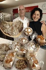
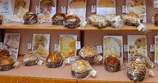
In der Gemeinde Maggia ist die Pannetteria Poncini domiziliert. Eine typische Dorfbäckerei mit Maggiatal-Brot (Spezialität aus dem Tal). Mehrfach wurde Poncini für seine Panettone (Tessiner Art) prämiert. Eine Sünde wert.
Cevio Vecchio
- Pfarrkirche Santi Maria Assunta e Giovanni Battista, Zentralbau aus dem 16. Jahrhundert mit Erweiterungen und Umbauten aus dem 17., 19. und frühen 20. Jahrhundert; Beinhaus von 1739
- Case Franzoni, stattliche Gruppe herrschaftlicher Häuser aus dem 16. bis 18. Jahrhundert
- Palazzo Franzoni (heute Museum des Maggiatals, 1. Ausstellungsgebäude), erbaut 1630, mit Wand- und Sgraffito-Malereien von 1688
- Casa Franzoni, mit zweiarmiger Treppe und Portal sowie freskierten Wappen aus dem 18. Jahrhundert
- Casa Respini-Moretti (heute Museum des Maggiatals, 2. Ausstellungsgebäude), erbaut im 17. und umgebaut im 18. Jahrhundert
Am Fusse des rechten Talhanges über Cevio Vecchio, unmittelbar hinter dem Museum, befindet sich der Schuttkegel eines grossen Felssturzes, der durch den Einsturz der 300 Meter darüber liegenden Felswand entstanden ist.
Zwischen den grossen Felsblöcken wurden auf einer Fläche von etwa zwei Hektaren mehr als 60 Keller gegraben, die den Kern der so genannten Grotti bilden. Ein Netz von schmalen engen Wegen durchzieht die gesamte Zone und ermöglicht den Zugang zu den verschiedenen Räumen, von denen einige sehr tief sind. Der Museumsverein plant den Ausbau des Lehrpfades.
www.museovalmaggia.ch/de
Cevio Piazza
- Dorfplatz, erbaut nach dem Baureglement von 1833
- Casa Calanchini-Respini, erbaut im 17. Jahrhundert, früherer Wohnsitz der Landvögte
- Villa Respini, erbaut 1890, mit raffinierter Dekorationsmalerei
- Pretorio, ehemaliges Vogteigebäude aus der Mitte des 16. Jahrhunderts, mit freskierten Wappen der Kantone und der Landvögte aus dem 17. und 18. Jahrhundert
- An der Piazza ist ein kleines Lebensmittelgeschäft mit lokalen Produkten aus dem Maggiatal
-
Send-To-Car (Zenec)
-
46.3382 8.6089
-
46° 20' 17.5" N 8° 36' 31.9" E
Bavonatal Wanderungen (www.ticinotopten.ch/de/wanderungen/bavonatal-tessin)
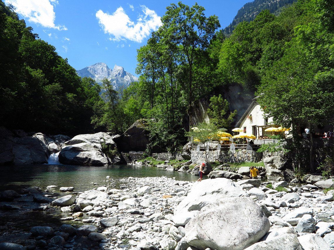
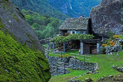
Das Bavonatal, das vom Maggiatal abzweigt, ist ein sehr wildes Tal. Noch heute gibt es dort keinen elektrischen Strom und es wird nur im Sommer bewohnt. Der Zauber der Natur, zusammen mit von Menschenhand Geschaffenem, hat diesem Tal Frieden und Harmonie verliehen. Eines der schönsten Tessiner Täler, mit hohen Felshängen und Resten von kolossalen Bergrutschen, die es auch zu einem der steilsten und steinigsten der gesamten Alpen machen. Eine wunderschöne Wanderung, die durch die zwölf Siedlungen im Tal führt, unter anderem Foroglio mit seinem herrlichen Wasserfall, erlaubt es dem Besucher, diese faszinierende Welt zu schätzen.
Rundgang: Bavonatal (5 St., Karte)
Die Wanderung ist nicht nur wegen des naturalistischen Aspekts faszinierend, sondern auch wegen der Eingriffe seitens der Menschen, die es verstanden haben, die Landschaft zu interpretieren und sich auch die noch so feindseligen Naturelemente zu Verbündeten zu machen. Sehr interessant sind die sogenannten splüi (Bauten unter den Felsen), die es erlaubten, die Natur den menschlichen Bedürfnissen anzupassen und somit zu Unterschlupf, Wohnung und Stall wurden. Erstaunlich auch die geniale Idee, auf den oberen Flächen der massigen Felsbrocken kleine Gemüsegärten anzubauen, um sie dort vor der Gefrässigkeit der Ziegen zu schützen. Die Wanderung, die durch das gesamte Bavonatal führt, kann in Bignasco oder in Cavergno beginnen. Entlang des Weges trifft man auf diverse splüi und durchquert Kastanienwälder. Der Kastanienbaum wurde früher der Baum des Lebens genannt, da er grundlegend für den Lebensunterhalt war. In Foroglio, der bekanntesten Dorf im Tal, wegen seines spektakulären Wasserfalls, scharen sich einige Häuser mit weitläufigen Lauben und Getreidespeicher um die kleine Kirche, in der sich ein interessanter Altar aus dem 16. Jhd. befindet. Ausserdem finden wir hier das Grotto Froda, das von Martino Giovanettina geführt wird, ein Intellektueller aus dem Maggiatal, der typische Tessiner Küche bietet. Interessant ist auch der Dorfkern von Sonlerto, wo die Wohnstätten zwischen den Felsbrocken eines prähistorischen Bergrutsches gebaut wurden, um dem Weideland nicht zu viel Fläche zu rauben. Das hübsche Oratorium von Gannariente mit wertvollen Fresken aus dem 16. Jhd. ist seit undenklichen Zeiten Ziel einer historischen Prozession, die am ersten Sonntag im Mai stattfindet. In San Carlo angekommen, demr letzten Ort im Bavonatal und auch der Ausgangspunkt der Seilbahn nach Robiei unter dem Basodino-Gletscher, kann man mit dem Postauto nach Bignasco oder Cavergno zurückfahren.
-
Send-To-Car (Zenec)
-
46.3993 8.653
-
46° 23' 57.6" N 8° 39' 10.7" E
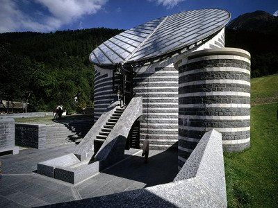
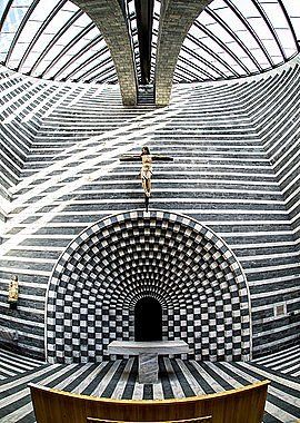
San Giovanni Battista (Hl. Johannes der Täufer) ist ein modernes römisch-katholisches Kirchengebäude in dem kleinen Bergdorf Mogno, Gemeinde Lavizzara. Die Kirche wurde von Mario Botta entworfen und in den Jahren 1992–1996 erbaut. Mario Botta * 1. April 1943 in Mendrisio, Kanton Tessin) ist ein Schweizer Architekt, Professor und Leiter der Accademia di Architettura der Università della Svizzera italiana in Mendrisio.
VorgeschichteHintergrund des Baus war die vollständige Zerstörung der alten barocken Dorfkirche von Mogno zusammen mit zahlreichen Häusern durch eine Lawine im Jahr 1986. Nach einer langen Phase der Planungen und Diskussionen entschied das Komitee für den Wiederaufbau, ein auffälliges, zukunftsweisendes Projekt zu wagen und den Plan des renommierten Luganer Architekten Botta zu realisieren. Seit ihrer Fertigstellung hat die Kirche zahlreiche Besucher angezogen.
ArchitekturBotta entwarf die Kirche als ein Zusammenspiel vielfältiger naturhafter und spiritueller Symbolik. Er gab ihr die Form eines turmartigen, oben in 45-Grad-Neigung abgeschrägten Ovals mit kreisrundem Glasdach. Die Kirche hat die gleiche Höhe wie der von der Lawine weggerissene Kirchturm. Als Baumaterial wählte er Marmor und Gneis in lagenweisem Wechsel und erzeugte dadurch einen reizvollen Hell-Dunkel-Effekt. Der Marmor stammt aus dem Steinbruch im nahen Val Peccia und ist gesägt. Der Gneis, Beola genannt, wurde in den Steinbrüchen von Riveo im Maggiatal gewonnen. Seine Oberfläche ist gehauen. Die unterschiedlichen Oberflächenbearbeitungen unterstreichen den genannten Effekt. Diese geometrische Form und die Farbkontraste sind Gestaltungs-Elemente, die Botta bereits beim San Francisco Museum of Modern Art (erbaut 1992–1995) verwendet hatte. Der Innenraum ist im Grundriss rechteckig; die Wände vollziehen den Wechsel vom Dachrund zum orthogonalen Boden in allmählichem Übergang. Der Altar steht vor einer quasi-byzantinischen rundbogigen, abgestuften Durchgangsnische, hinter der sich die Sakristei befindet – wegen der Hanglage unterirdisch und von aussen unsichtbar. Der Eingang auf der gegenüberliegenden Seite ist aussen unter einem kleinen treppenförmigen Aquädukt, innen hinter einer Säule verborgen. Die Wassertreppe, über die bei Regen das Wasser vom Dach abfliesst, setzt sich innen unter dem Glasdach in einer bogenförmigen „Himmelsleiter“ fort. Zwei weitere Nischen an den Schmalseiten des Raumes setzen in dem postmodernen Kontext zusätzliche archaische Akzente. Nur wenige Bankreihen aus hellem Holz verstellen den ebenfalls im Hell-Dunkel-Wechsel gestalteten Steinboden.
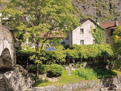
Das Grotto Pozzasc liegt in Peccia (oberes Maggiatal) an einem idyllischen Ort bei einem Naturbecken, das sich aus dem Fluss des Pecciatals geformt hat. Ursprünglich diente das Grotto als Mühle, wovon noch einige Baureste aus Holz und Stein zeugen. Jeden Tag werden am Kamin Polenta zubereitet und mit Voressen, verschiedene Käsesorten, Mortadella und Codegotto serviert. An den Granittischen im Schatten der grossen Bäume können sowohl die kulinarischen Köstlichkeiten als auch der herrliche Ausblick auf den Fluss genossen werden.
Travelogue