Unfortunately, we don't support your browser (Internet Explorer) anymore, some functionalities could not work. Click here to get information on how to upgrade your browser.

Tuscany of Baden-Württemberg

Travelogue
Stopover: Beilstein
Arrival: 11:00 a.m.
In Beilstein, we drove to the discounter ALDI before visiting the castle to buy the essentials for the day. There was so much going on at ALDI that a larger line of people lined up in front of the shopping carts. We went to the discounter REWE next door, this was normal shopping.
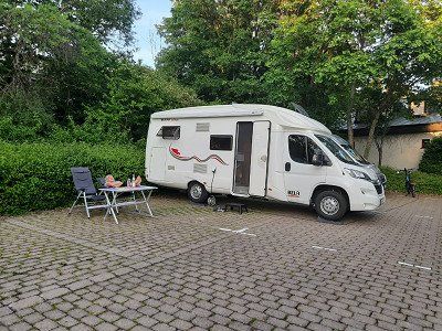
After shopping we drove to our planned parking lot at the sports area. (GPS: 49.041993,9.318279)
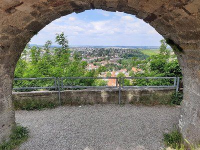
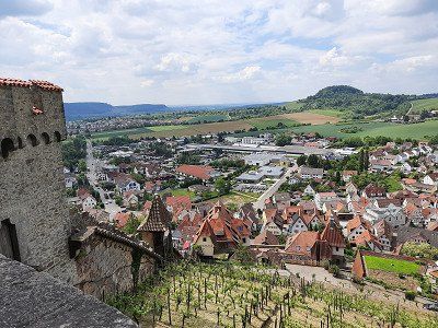
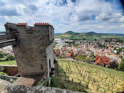
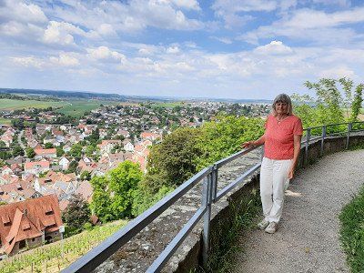
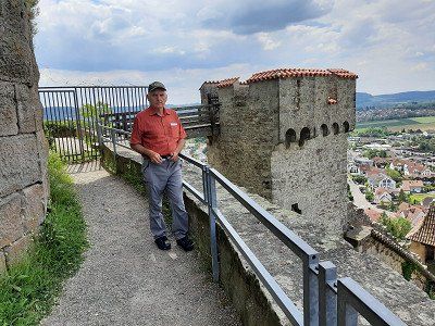
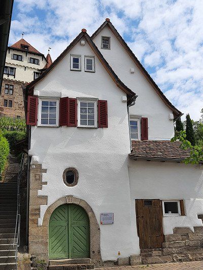
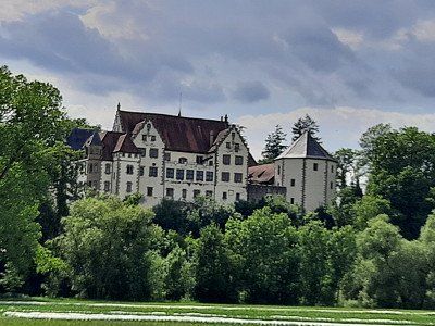
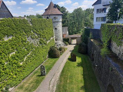
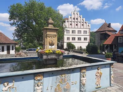
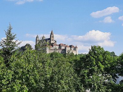
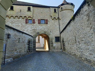
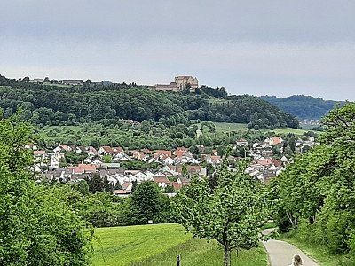
A free parking space was found at the sports grounds and schools. 10 minutes to the center. The path led us first to the castle, at the top of the castle there are two nice large parking lots. You could have parked well here, a camper parked. The castle is on a beautiful hill with a wonderful all-round view. No public traffic was encountered at the castle.
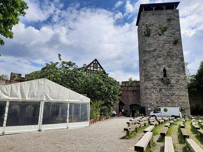
Hohenbeilstein Castle was built between 1070 and 1080.
When the builder family died out, the castle passed to the Margrave of Baden in 1234.
And that from a Count of Württemberg, something like that would be quite normal today, because the castle went back to Württemberg in 1340. Today you can visit the castle very well, because there is not only a restaurant in it, but also a falconry in the ruins.
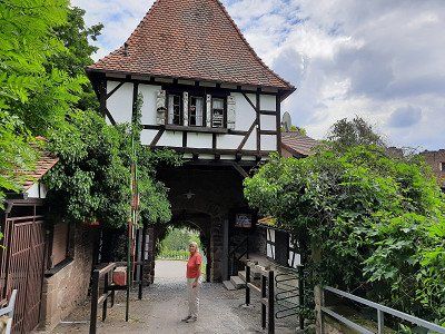
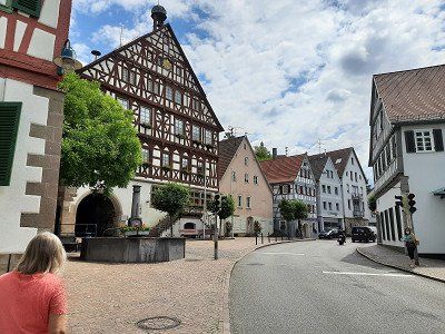
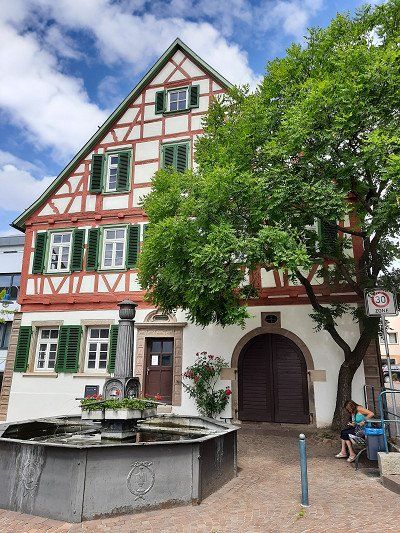
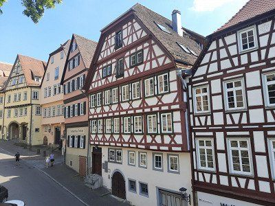
The town at the foot of the castle was only mentioned in a document in 1304. The town can impress with beautiful half-timbered houses. Beilstein is a wine town in the Heilbronn district, located at the foot of the Löwenstein Mountains. An hour of sightseeing is enough.
Stopover: Beilstein
Arrival: 11:00 a.m.
In Beilstein, we drove to the discounter ALDI before visiting the castle to buy the essentials for the day. There was so much going on at ALDI that a larger line of people lined up in front of the shopping carts. We went to the discounter REWE next door, this was normal shopping.
After shopping we drove to our planned parking lot at the sports area. (GPS: 49.041993,9.318279)
A free parking space was found at the sports grounds and schools. 10 minutes to the center. The path led us first to the castle, at the top of the castle there are two nice large parking lots. You could have parked well here, a camper parked. The castle is on a beautiful hill with a wonderful all-round view. No public traffic was encountered at the castle.
Hohenbeilstein Castle was built between 1070 and 1080.
When the builder family died out, the castle passed to the Margrave of Baden in 1234.
And that from a Count of Württemberg, something like that would be quite normal today, because the castle went back to Württemberg in 1340. Today you can visit the castle very well, because there is not only a restaurant in it, but also a falconry in the ruins.
The town at the foot of the castle was only mentioned in a document in 1304. The town can impress with beautiful half-timbered houses. Beilstein is a wine town in the Heilbronn district, located at the foot of the Löwenstein Mountains. An hour of sightseeing is enough.
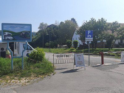
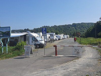
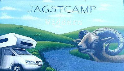
The seats were all reserved. No. 6 was the only one that only started on May 21. was reserved, the only free place for today. What luck for us!
Fee: 8 € with ES. Electricity with an extra charge.
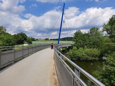
After the coffee break, I got our bicycles out of the garage and set off on the first bike tour towards Götzenburg and Schöntal Abbey for the time being along the Jagst.
The seats were all reserved. No. 6 was the only one that only started on May 21. was reserved, the only free place for today. What luck for us!
Fee: 8 € with ES. Electricity with an extra charge.
After the coffee break, I got our bicycles out of the garage and set off on the first bike tour towards Götzenburg and Schöntal Abbey for the time being along the Jagst.
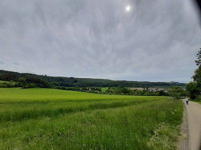
The Jagst is a low mountain river in the north of Baden-Württemberg. In addition to the Kocher and the Enz, it is one of the three largest tributaries of the Neckar with a length of 190.2 kilometers. Many natural sections invite you to cycle.
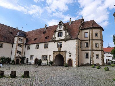
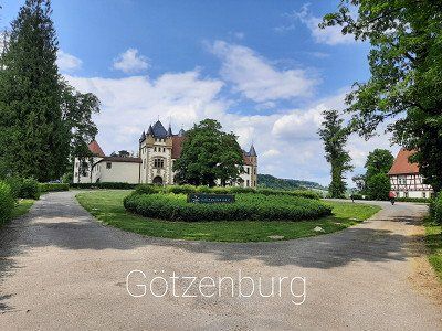
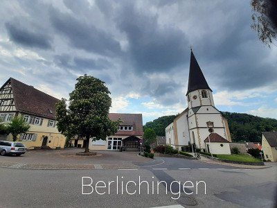
The first sight was the Jagsthausen Castle, later also the Old Castle, and more recently in Jagsthausen, based on Goethe's drama Götz von Berlichingen Götzenburg. In front of the Schöntal monastery we drive through the village of Berlichingen, whose church we looked at.
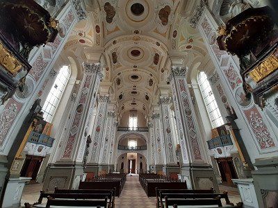
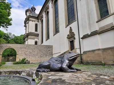
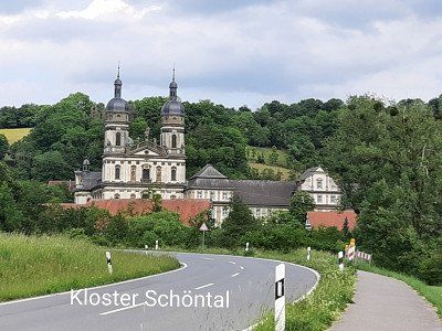
Schöntal an der Jagst Monastery is a former Cistercian abbey with an ornate baroque church.
Round trip: 36 km. The Jagsttal is a beautiful landscape ideal for cycling, great bike paths.


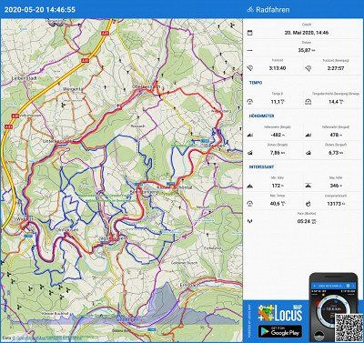
The Jagst is a low mountain river in the north of Baden-Württemberg. In addition to the Kocher and the Enz, it is one of the three largest tributaries of the Neckar with a length of 190.2 kilometers. Many natural sections invite you to cycle.
The first sight was the Jagsthausen Castle, later also the Old Castle, and more recently in Jagsthausen, based on Goethe's drama Götz von Berlichingen Götzenburg. In front of the Schöntal monastery we drive through the village of Berlichingen, whose church we looked at.
Schöntal an der Jagst Monastery is a former Cistercian abbey with an ornate baroque church.
Round trip: 36 km. The Jagsttal is a beautiful landscape ideal for cycling, great bike paths.
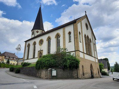
Before we continued our journey, we looked around in the smallest town in Baden Württemberg.
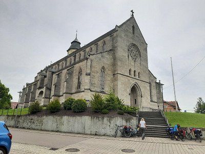
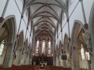
The Evangelical Laurentiuskirche was mentioned for the first time in 1258 and was rebuilt in its present form from 1892 to 1895 while maintaining the late Gothic core of the building. Grave monuments from the 15th to the 18th centuries have been preserved in the church.
You could see individual half-timbered houses


Before we continued our journey, we looked around in the smallest town in Baden Württemberg.
The Evangelical Laurentiuskirche was mentioned for the first time in 1258 and was rebuilt in its present form from 1892 to 1895 while maintaining the late Gothic core of the building. Grave monuments from the 15th to the 18th centuries have been preserved in the church.
You could see individual half-timbered houses
When we arrived at the parking space in Michelbach GPS: 49.071301,9.769860, there was a camper on the pitch. The two marked parking spaces for campers were still free, of which we placed our Womo in first place. Electricity, water and parking fees are free. A short time later two more womos came, so we were lucky to get a parking space.
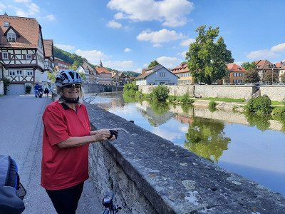
We got the bikes out of the garage and got ready for the second bike tour on this trip, which led to Vellberg - Schwäbisch Hall and the former Comburg monastery.


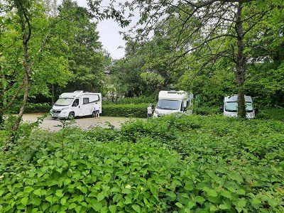

When we arrived at the parking space in Michelbach GPS: 49.071301,9.769860, there was a camper on the pitch. The two marked parking spaces for campers were still free, of which we placed our Womo in first place. Electricity, water and parking fees are free. A short time later two more womos came, so we were lucky to get a parking space.
We got the bikes out of the garage and got ready for the second bike tour on this trip, which led to Vellberg - Schwäbisch Hall and the former Comburg monastery.
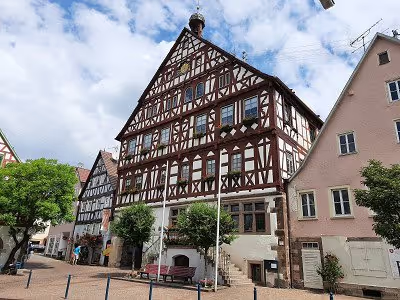
Vellberg was our first goal. We were amazed at the magnificent city complex with its preserved city walls, towers and city gates. It is gigantic and the height of the city wall. The many half-timbered houses are also impressive with their construction. As nice as the town is the gastronomy is to be criticized in the coffee one was stupid and in another gas station one was not served despite repeated requests to the waitress. For these reasons we saw a stop from here. (I think everything works differently without Corona).
The onward journey to Schwäbisch Hall was also not without problems, in part the cycle paths were poorly signposted due to the lack of signs and once the cycle path ended in a newly built construction area. Here we had lost quite a bit of time and effort to get back on the bike path. This section of the route between the two cities was easy to drive, you could do a lot without an electric motor.
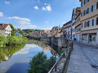
Schwäbisch Hall was of course the highlight of the tour, I did not imagine the city as impressive. The beautiful facades of the half-timbered houses, the narrow streets with the picturesque gables. The old wooden bridges that lead over the Kocher and the river itself give the city a very special flair. Unfortunately the church, which we would have liked to see, was already closed when we arrived.
In a coffee right outside the church we enjoyed our piece of cake in wonderful summer weather.
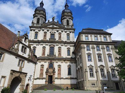
Continue to the last stage of the round tour, the former Comburg monastery. At first it was difficult to find the right way out of the alleys of the old town, which led to the Comburg. In front of the monastery, a beautiful avenue with chestnut trees leads up to Comburg.
The Comburg, also written Komburg and called Großcomburg, is a former Benedictine monastery and later knighthood.
The Großcomburg was founded in 1078. The castle-like complex with its walls, towers, chapels and buildings experienced its first flowering during the Staufer period.
The Großcomburg Abbey rises majestically and majestically high above the Kochertal Valley - a monument of European rank.The Großcomburg grounds are freely accessible and the 420 m long walk-in walkway offers wonderful views of the city of Schwäbisch Hall and the panoramic mountain Einkorn (510 m high) ).
It is known for two treasures: the gold-plated antependium and the Romanesque chandelier.
Visiting the Church of St. Nicholas is only possible on short tours. Unfortunately, the church is closed to visitors due to Corone, so all we had to do was visit the complex with the rampart.
After an extensive inspection, we continue our journey, it was only a few kilometers to our parking space in Michelbach.


Vellberg was our first goal. We were amazed at the magnificent city complex with its preserved city walls, towers and city gates. It is gigantic and the height of the city wall. The many half-timbered houses are also impressive with their construction. As nice as the town is the gastronomy is to be criticized in the coffee one was stupid and in another gas station one was not served despite repeated requests to the waitress. For these reasons we saw a stop from here. (I think everything works differently without Corona).
The onward journey to Schwäbisch Hall was also not without problems, in part the cycle paths were poorly signposted due to the lack of signs and once the cycle path ended in a newly built construction area. Here we had lost quite a bit of time and effort to get back on the bike path. This section of the route between the two cities was easy to drive, you could do a lot without an electric motor.
Schwäbisch Hall was of course the highlight of the tour, I did not imagine the city as impressive. The beautiful facades of the half-timbered houses, the narrow streets with the picturesque gables. The old wooden bridges that lead over the Kocher and the river itself give the city a very special flair. Unfortunately the church, which we would have liked to see, was already closed when we arrived.
In a coffee right outside the church we enjoyed our piece of cake in wonderful summer weather.
Continue to the last stage of the round tour, the former Comburg monastery. At first it was difficult to find the right way out of the alleys of the old town, which led to the Comburg. In front of the monastery, a beautiful avenue with chestnut trees leads up to Comburg.
The Comburg, also written Komburg and called Großcomburg, is a former Benedictine monastery and later knighthood.
The Großcomburg was founded in 1078. The castle-like complex with its walls, towers, chapels and buildings experienced its first flowering during the Staufer period.
The Großcomburg Abbey rises majestically and majestically high above the Kochertal Valley - a monument of European rank.The Großcomburg grounds are freely accessible and the 420 m long walk-in walkway offers wonderful views of the city of Schwäbisch Hall and the panoramic mountain Einkorn (510 m high) ).
It is known for two treasures: the gold-plated antependium and the Romanesque chandelier.
Visiting the Church of St. Nicholas is only possible on short tours. Unfortunately, the church is closed to visitors due to Corone, so all we had to do was visit the complex with the rampart.
After an extensive inspection, we continue our journey, it was only a few kilometers to our parking space in Michelbach.


In Abtsgmünd we wanted to visit the castle garden, it should be beautifully laid out. We found and saw no castle, so we visited the local church, which is also beautiful.
The Catholic parish church of St. Michael is a neo-Gothic basilica with a late Romanesque basement. The Rechberg Cross has been in front of the church since 1994; this cross, dated to 1331, is the second oldest stone cross in Baden-Württemberg. It was probably created by a sideline of the Counts of Rechberg.
We used the parking lot to park, it is big enough for our Womo and is on the outskirts of the city on the railway line. Good starting point for our hike.

We used the parking lot to park, it is big enough for our Womo and is on the outskirts of the city on the railway line. Good starting point for our hike.
The Kapfenburg is located on a mountain nose of the Albtrauf, 130 meters above the city of Lauchheim.
After the fall of the Staufer, the Counts of Oettingen and their feudal lords, the Lords of Gromberg, took over a large part of the lands around the Kapfenburg. In 1364 the Teutonic Order House Mergentheim acquired the castle. It was the last coming foundation of the order in southern Germany. The religious state in Prussia and the religious houses in the empire were already living apart. The Kapfenburg is above all a testimony to a small spiritual and knightly residence of the late Middle Ages and early modern times.
In the Rhine Confederation Act of 1806, Napoleon abolished the Teutonic Order and awarded the Kapfenburg to King Friedrich of Württemberg. Since then it has been owned by the country.
The further hiking trail ran through various forests, mainly Buchenwald. We stopped at the beautiful stone hiking point. The further route now went downhill to the town of Lauchheim. We were quite surprised when we came across a beautiful city gate with remains of the old city wall. Tower tower system from 1621 with octagonal tower with coat of arms as
Part of the city fortifications built around 1400. A few half-timbered gables can still be seen in the center.
The Catholic parish church of St. Peter and Paul is worth seeing.
In an elevated topographical position and eaves oriented towards the main street, the tower from the period around 1500, the nave with the octagonal choir tower after the city fire in neoclassical style in 1869 by G. v. Morlock renewed in sandstone.
On the way to the camper we used the little detour through the center to get to know the place better.
The monastery complex could only be visited from the outside, due to the Corona crisis, the monastery and church are closed to visitors and no church services were held.
The Neresheim Abbey is a Benedictine monastery in the Diocese of Rottenburg-Stuttgart in Baden-Württemberg and a member of the Beuron Congregation. The monastery complex is located above the town of Neresheim on the Ulrichsberg in a dominant position above the Härtsfeld. The monastery was founded in 1095 by Count Hartmann I von Dillingen and his wife Adelheid von Winterthur-Kyburg, presumably a daughter of the last Winterthur Count Adalbert II the count of Kyburg, founded as an Augustinian canon at his castle in Neresheim and converted in 1106 into a Benedictine abbey, which joined the Hirsau reform. The first (Benedictine) monks came from Petershausen Abbey in 1106 and a second group from Zwiefalten Abbey in 1119. In addition to the men's community, there was also a women's convent, which however entered into in the middle of the 13th century.
After the monastery tour in the monastery courtyard, we went back to the Womo. Now the decision was to spend the night here or to move to another parking space. We refrained from spending the night in the parking lot, the space was too sloping. We decided to drive to the parking space in Heidenheim an der Brenz for the night. Heidenheim is new to us and is definitely an interesting place with its castle.
22 parking spaces, asphalt access, gravel underground. On arrival the place was 50% full.
Arrived at the parking space around 6:30 p.m.
We ended the day with dinner and sat in front of the Womo. It became significantly cooler, as in the evenings of the past few days.


22 parking spaces, asphalt access, gravel underground. On arrival the place was 50% full.
Arrived at the parking space around 6:30 p.m.
We ended the day with dinner and sat in front of the Womo. It became significantly cooler, as in the evenings of the past few days.
In the city center there is the Evangelical Michaelskirche (old parish church of the city), the Elmar Doch House (Touristik Info) with the Knöpfleswäscherin fountain. At other Protestant churches in the core city there is the Evangelische Pauluskirche (built 1895-1898, today's main and dean's church) which was open and we visited
Two hours are enough to visit the museum without visiting it. After returning from the motorhome it started to rain and we drove straight to Owen, where our grandchildren were waiting for us.
Route
Show newest first- 48.1978 8.6944
- 48° 11' 52" N 8° 41' 40" E
Die Jagst ist ein Mittelgebirgsfluss im Norden Baden-Württembergs. Neben dem Kocher und der Enz zählt sie zu den drei größten Nebenflüssen des Neckars mit der Länge 190,2 Kilometern. Viele naturbelassene Abschnitte laden zum Radfahren ein.
Die erste Sehenswürdigkeit war die Burg Jagsthausen, später auch Altes Schloss und in jüngerer Zeit in Anlehnung an Goethes Drama Götz von Berlichingen Götzenburg genannt, in Jagsthausen. Vor dem Kloster Schöntal durchfahren wir die Ortschaft Berlichingen deren Kirche wir anschauten.
Das Kloster Schöntal an der Jagst ist eine ehemalige Zisterzienserabtei mit einer kunstvollen Barockkirche.
Rundtour: 36 km. Das Jagsttal ist eine schöne Landschaft ideal zum Radeln, super Radwege.
Vor der Weiterfahrt sahen wir uns in der kleinsten Stadt Baden Württemberg um.
Die evangelische Laurentiuskirche wurde 1258 erstmals erwähnt und in ihrer heutigen Form unter Beibehaltung des spätgotischen Gebäudekerns von 1892 bis 1895 neu erbaut. In der Kirche sind Grabdenkmäler vom 15. bis zum 18. Jahrhundert erhalten.
Zu sehen waren einzelne Fachwerkhäuser
- 49.0694 9.7642
- 49° 4' 9.7" N 9° 45' 51.2" E
Vellberg war unser erstes Ziel. Wir waren erstaunt über die prächtige Stadtanlage mit ihrer erhaltenen Stadtmauer, Türme und Stadttore. Sie ist gigantisch und was für eine Höhe die Stadtmauer aufweist. Auch die vielen Fachwerkhäuser sind beeindruckend mit ihrer Bauweise. So schön auch das Städtchen ist die Gastronomie ist zu bemängeln im Kaffee wurde man blöd angegangen und in einer weiteren Gasstätte wurde man trotz mehrmaliger Aufforderung an die Bedienung nicht bedient.Aus diesen Gründen sahen wir ab hier eine Einkehr zu machen. (Ich denke ohne Corona läuft hier alles anders).
Die Weiterfahrt nach Schwäbisch Hall war auch nicht ganz ohne Probleme, zum Teil waren die Radwege schlecht ausgeschildert wegen fehlender Schilder und einmal endete der Radweg an einem neu angelegtem Baugebiet. Hier hatten wir ziemliche Zeit verloren und Mühe, um wieder auf den Radweg zu gelangen. Dieser Streckenabschnitt zwischen den zwei Städten war eben zu befahren, man konnte viel ohne E-Motor zurücklegen.
Schwäbisch Hall war natürlich das Highlight der Tour, so beeindruckend habe ich mir die Stadt nicht vorgestellt. Die wunderschönen Fassaden der Fachwerkhäuser, die engen Gassen mit den malerischen Hausgiebeln. Die alten Holzbrücken die über die Kocher führen und der Fluss selbst geben der Stadt ein ganz besonderes Flair. Leider hatte die Kirche bei unserer Ankunft schon geschlossen, die wir gerne uns angeschaut hätten.
In einem Kaffee unmittelbar bei der Kirche im Freien genossen wir unser Torten Stück bei herrlichem Sommerwetter.
Weiterfahrt zum letzten Etappenziel der Rundtour, das ehemalige Kloster Comburg. Anfangs war es schwierig aus den Gassen der Altstadt den Richtigen Weg zu finden, der zur Comburg führte. Vor dem Kloster führt eine schöne Allee mit Kastanienbäume hinauf zur Comburg.
Die Comburg, auch Komburg geschrieben und Großcomburg genannt, ist ein ehemaliges Kloster der Benediktiner und späteres Ritterstift.
Die Großcomburg wurde im Jahre 1078 gegründet. Die burgartige Anlage mit ihren Mauern, Türmen, Kapellen und Gebäuden erlebte ihre erste Blüte während der Stauferzeit.
Hoch über dem Kochertal erhebt sich wehrhaft und majestätisch das Kloster Großcomburg - ein Monument von europäischem Rang.Die Außenanlage der Großcomburg ist frei zugänglich und der 420 m lange umlaufend begehbare Wehrgang bietet wunderbare Ausblicke auf die Stadt Schwäbisch Hall und den Aussichtsberg Einkorn (510 m hoch).
Für zwei Kostbarkeiten ist es bekannt: das vergoldete Antependium und den romanischen Radleuchter.
Besichtigung der Kirche St. Nikolaus ist nur im Rahmen von Kurzführungen möglich. Leider ist die Kirche wegen Corone für Besucher geschlossen so blieb uns nur die Anlage mit Wehrgang zu besichtigen.
Nach ausgiebiger Besichtigung setzen wir unsere Fahrt fort, es waren nur noch wenige Kilometer bis zu unserem Stellplatz in Michelbach.
- 48.8713 10.2433
- 48° 52' 16.9" N 10° 14' 35.8" E
Die Kapfenburg liegt auf einer Bergnase des Albtraufs, 130 Meter über der Stadt Lauchheim.
Nach dem Untergang der Staufer übernahmen die Grafen von Oettingen und ihre Lehnsherren, die Herren von Gromberg, einen Großteil der Ländereien um die Kapfenburg. 1364 erwarb das Deutschordenshaus Mergentheim das Schloss. Es war die letzte Kommendegründung des Ordens im süddeutschen Raum. Der Ordensstaat in Preußen und die Ordenshäuser im Reich lebten sich bereits auseinander. So gibt die Kapfenburg vor allem Zeugnis über eine kleine geistlich-ritterliche Residenz des späten Mittelalters und der frühen Neuzeit.
In der Rheinbundakte von 1806 hob Napoleon den Deutschen Orden auf und sprach die Kapfenburg König Friedrich von Württemberg zu. Seither ist sie im Besitz des Landes.
Der weiterführende Wanderweg verlief eben durch verschiedene Wälder, überwiegend Buchenwalder. Beim Wanderpunkt schöner Stein legten wir eine Rast ein. Die weitere Wegstrecke führte nun bergab bis ins Städtchen Lauchheim. Wir waren ganz überrascht als wir auf ein schönes Stadttor stoßen mit Reste der alten Stadtmauer Stadtmauer.Torturmanlage von 1621 mit oktogonalem Turm mit Wappentafel als
Bestandteil der um 1400 errichteten Stadtbefestigung. Im Zentrum sind noch wenige Fachwerkhäusergiebel zu betrachten.
Die Kath. Pfarrkirche St. Peter und Paul ist sehenswert.
In erhöhter topographischer Lage und traufständig zur Hauptstraße ausgerichteter Kirchenbau, der Turm aus der Zeit um 1500, das Langhaus samt oktogonalem Chorturm nach dem Stadtbrand in neoklassizistischem Stil 1869 von G. v. Morlock in Sandstein erneuert.
Auf dem Weg zum Wohnmobil nutzten wir den kleinen Abstecher durchs Zentrum um den Ort näher kennen zu lernen.
- 48.7559 10.3437
- 48° 45' 21.1" N 10° 20' 37.4" E
- 48.6944 10.1631
- 48° 41' 40" N 10° 9' 47" E
In der Innenstadt befinden sich die evangelische Michaelskirche (alte Pfarrkirche der Stadt), das Elmar-Doch-Haus (Touristik Info) mit dem Knöpfleswäscherin-Brunnen. An weiteren evangelischen Kirchen in der Kernstadt gibt es die Evangelische Pauluskirche (erbaut 1895–1898, heutige Haupt- und Dekanatskirche) die geöffnet war und wir besichtigten
Zwei Stunden reichen aus für die Besichtigung ohne Museumsbesuche. Nach Rückkehr am Wohnmobil fing es auch an zu regnen und wir fuhren gleich los auf kürzesten Weg nach Owen, wo unsere Enkel auf uns warteten.
- 48.5878 9.4501
- 48° 35' 16.1" N 9° 27' 0.3" E
- 48.1978 8.6944
- 48° 11' 52" N 8° 41' 40" E
Travelogue
Stopover: Beilstein
Arrival: 11:00 a.m.
In Beilstein, we drove to the discounter ALDI before visiting the castle to buy the essentials for the day. There was so much going on at ALDI that a larger line of people lined up in front of the shopping carts. We went to the discounter REWE next door, this was normal shopping.
After shopping we drove to our planned parking lot at the sports area. (GPS: 49.041993,9.318279)
A free parking space was found at the sports grounds and schools. 10 minutes to the center. The path led us first to the castle, at the top of the castle there are two nice large parking lots. You could have parked well here, a camper parked. The castle is on a beautiful hill with a wonderful all-round view. No public traffic was encountered at the castle.
Hohenbeilstein Castle was built between 1070 and 1080.
When the builder family died out, the castle passed to the Margrave of Baden in 1234.
And that from a Count of Württemberg, something like that would be quite normal today, because the castle went back to Württemberg in 1340. Today you can visit the castle very well, because there is not only a restaurant in it, but also a falconry in the ruins.
The town at the foot of the castle was only mentioned in a document in 1304. The town can impress with beautiful half-timbered houses. Beilstein is a wine town in the Heilbronn district, located at the foot of the Löwenstein Mountains. An hour of sightseeing is enough.
The seats were all reserved. No. 6 was the only one that only started on May 21. was reserved, the only free place for today. What luck for us!
Fee: 8 € with ES. Electricity with an extra charge.
After the coffee break, I got our bicycles out of the garage and set off on the first bike tour towards Götzenburg and Schöntal Abbey for the time being along the Jagst.
The Jagst is a low mountain river in the north of Baden-Württemberg. In addition to the Kocher and the Enz, it is one of the three largest tributaries of the Neckar with a length of 190.2 kilometers. Many natural sections invite you to cycle.
The first sight was the Jagsthausen Castle, later also the Old Castle, and more recently in Jagsthausen, based on Goethe's drama Götz von Berlichingen Götzenburg. In front of the Schöntal monastery we drive through the village of Berlichingen, whose church we looked at.
Schöntal an der Jagst Monastery is a former Cistercian abbey with an ornate baroque church.
Round trip: 36 km. The Jagsttal is a beautiful landscape ideal for cycling, great bike paths.
Before we continued our journey, we looked around in the smallest town in Baden Württemberg.
The Evangelical Laurentiuskirche was mentioned for the first time in 1258 and was rebuilt in its present form from 1892 to 1895 while maintaining the late Gothic core of the building. Grave monuments from the 15th to the 18th centuries have been preserved in the church.
You could see individual half-timbered houses
When we arrived at the parking space in Michelbach GPS: 49.071301,9.769860, there was a camper on the pitch. The two marked parking spaces for campers were still free, of which we placed our Womo in first place. Electricity, water and parking fees are free. A short time later two more womos came, so we were lucky to get a parking space.
We got the bikes out of the garage and got ready for the second bike tour on this trip, which led to Vellberg - Schwäbisch Hall and the former Comburg monastery.
Vellberg was our first goal. We were amazed at the magnificent city complex with its preserved city walls, towers and city gates. It is gigantic and the height of the city wall. The many half-timbered houses are also impressive with their construction. As nice as the town is the gastronomy is to be criticized in the coffee one was stupid and in another gas station one was not served despite repeated requests to the waitress. For these reasons we saw a stop from here. (I think everything works differently without Corona).
The onward journey to Schwäbisch Hall was also not without problems, in part the cycle paths were poorly signposted due to the lack of signs and once the cycle path ended in a newly built construction area. Here we had lost quite a bit of time and effort to get back on the bike path. This section of the route between the two cities was easy to drive, you could do a lot without an electric motor.
Schwäbisch Hall was of course the highlight of the tour, I did not imagine the city as impressive. The beautiful facades of the half-timbered houses, the narrow streets with the picturesque gables. The old wooden bridges that lead over the Kocher and the river itself give the city a very special flair. Unfortunately the church, which we would have liked to see, was already closed when we arrived.
In a coffee right outside the church we enjoyed our piece of cake in wonderful summer weather.
Continue to the last stage of the round tour, the former Comburg monastery. At first it was difficult to find the right way out of the alleys of the old town, which led to the Comburg. In front of the monastery, a beautiful avenue with chestnut trees leads up to Comburg.
The Comburg, also written Komburg and called Großcomburg, is a former Benedictine monastery and later knighthood.
The Großcomburg was founded in 1078. The castle-like complex with its walls, towers, chapels and buildings experienced its first flowering during the Staufer period.
The Großcomburg Abbey rises majestically and majestically high above the Kochertal Valley - a monument of European rank.The Großcomburg grounds are freely accessible and the 420 m long walk-in walkway offers wonderful views of the city of Schwäbisch Hall and the panoramic mountain Einkorn (510 m high) ).
It is known for two treasures: the gold-plated antependium and the Romanesque chandelier.
Visiting the Church of St. Nicholas is only possible on short tours. Unfortunately, the church is closed to visitors due to Corone, so all we had to do was visit the complex with the rampart.
After an extensive inspection, we continue our journey, it was only a few kilometers to our parking space in Michelbach.
In Abtsgmünd we wanted to visit the castle garden, it should be beautifully laid out. We found and saw no castle, so we visited the local church, which is also beautiful.
The Catholic parish church of St. Michael is a neo-Gothic basilica with a late Romanesque basement. The Rechberg Cross has been in front of the church since 1994; this cross, dated to 1331, is the second oldest stone cross in Baden-Württemberg. It was probably created by a sideline of the Counts of Rechberg.
We used the parking lot to park, it is big enough for our Womo and is on the outskirts of the city on the railway line. Good starting point for our hike.
We used the parking lot to park, it is big enough for our Womo and is on the outskirts of the city on the railway line. Good starting point for our hike.
The Kapfenburg is located on a mountain nose of the Albtrauf, 130 meters above the city of Lauchheim.
After the fall of the Staufer, the Counts of Oettingen and their feudal lords, the Lords of Gromberg, took over a large part of the lands around the Kapfenburg. In 1364 the Teutonic Order House Mergentheim acquired the castle. It was the last coming foundation of the order in southern Germany. The religious state in Prussia and the religious houses in the empire were already living apart. The Kapfenburg is above all a testimony to a small spiritual and knightly residence of the late Middle Ages and early modern times.
In the Rhine Confederation Act of 1806, Napoleon abolished the Teutonic Order and awarded the Kapfenburg to King Friedrich of Württemberg. Since then it has been owned by the country.
The further hiking trail ran through various forests, mainly Buchenwald. We stopped at the beautiful stone hiking point. The further route now went downhill to the town of Lauchheim. We were quite surprised when we came across a beautiful city gate with remains of the old city wall. Tower tower system from 1621 with octagonal tower with coat of arms as
Part of the city fortifications built around 1400. A few half-timbered gables can still be seen in the center.
The Catholic parish church of St. Peter and Paul is worth seeing.
In an elevated topographical position and eaves oriented towards the main street, the tower from the period around 1500, the nave with the octagonal choir tower after the city fire in neoclassical style in 1869 by G. v. Morlock renewed in sandstone.
On the way to the camper we used the little detour through the center to get to know the place better.
The monastery complex could only be visited from the outside, due to the Corona crisis, the monastery and church are closed to visitors and no church services were held.
The Neresheim Abbey is a Benedictine monastery in the Diocese of Rottenburg-Stuttgart in Baden-Württemberg and a member of the Beuron Congregation. The monastery complex is located above the town of Neresheim on the Ulrichsberg in a dominant position above the Härtsfeld. The monastery was founded in 1095 by Count Hartmann I von Dillingen and his wife Adelheid von Winterthur-Kyburg, presumably a daughter of the last Winterthur Count Adalbert II the count of Kyburg, founded as an Augustinian canon at his castle in Neresheim and converted in 1106 into a Benedictine abbey, which joined the Hirsau reform. The first (Benedictine) monks came from Petershausen Abbey in 1106 and a second group from Zwiefalten Abbey in 1119. In addition to the men's community, there was also a women's convent, which however entered into in the middle of the 13th century.
After the monastery tour in the monastery courtyard, we went back to the Womo. Now the decision was to spend the night here or to move to another parking space. We refrained from spending the night in the parking lot, the space was too sloping. We decided to drive to the parking space in Heidenheim an der Brenz for the night. Heidenheim is new to us and is definitely an interesting place with its castle.
22 parking spaces, asphalt access, gravel underground. On arrival the place was 50% full.
Arrived at the parking space around 6:30 p.m.
We ended the day with dinner and sat in front of the Womo. It became significantly cooler, as in the evenings of the past few days.
22 parking spaces, asphalt access, gravel underground. On arrival the place was 50% full.
Arrived at the parking space around 6:30 p.m.
We ended the day with dinner and sat in front of the Womo. It became significantly cooler, as in the evenings of the past few days.
In the city center there is the Evangelical Michaelskirche (old parish church of the city), the Elmar Doch House (Touristik Info) with the Knöpfleswäscherin fountain. At other Protestant churches in the core city there is the Evangelische Pauluskirche (built 1895-1898, today's main and dean's church) which was open and we visited
Two hours are enough to visit the museum without visiting it. After returning from the motorhome it started to rain and we drove straight to Owen, where our grandchildren were waiting for us.
Comments (3)
Comments from Freeontour users
Danke für die gute Beschreibung und die vielen Bilder.
Eine gute und ausführliche Reisebeschreibung für Coronazeit. Danke!
Eine wirklich auch sehr gut dokumentierte Tour - danke dafür. An Vellberg haben wir schon vor 40 Jahre schöne Erinnerungen. Damals wurde an der Restaurierung der Wehranlagen noch gearbeitet und uns wurde erzählt, dass jeder Bewohner im Ort verpflichtet war daran mitzuwirken. Das Ergebnis dieser Bemühungen dürfte inzwischen sicher herausragend sein. Der Besuch in Vellberg lohnt sich im Übrigen auch für die Weiterfahrt nach München. Dort lohnt zumindest eine Zwischenübernachtung.