
Spring is the best time of year to try out winter camping in Norway with your motorhome. Strap on your cross-country skis or snowshoes and explore the area around the mountains in the eastern part of Jotunheimen National Park, which is still covered in deep snow in 'spring winter', i.e. an additional season in the far north of Scandinavia consisting of wintry weather in early spring. Randsverk is a great starting point for your adventure thanks to its year-round campsite.
Our tip for spring winter: the Valdresflye National Scenic Route
Many Norwegians look forward to spring after the long, dark winter: there's more sunshine during the day, temperatures are just above zero, yet the nights are still so cold that the snow doesn't melt away – perfect for all kinds of outdoor activities. These conditions usually fall between mid-March and the end of April, therefore often during the Easter holidays.
There is another advantage to caravanning in Norway in spring winter: depending on the weather, a few scenic routes that are usually closed during winter are open again from mid/end March. Instead of driving on the motorway, you could travel at a leisurely pace through Norway on a number of scenic roads, e.g. the Valdresflye National Scenic Route towards Jotunheimen National Park. The walls of snow lining the road are often several metres high, reaching up to the sky. The road literally cuts its way through spring winter in the eastern edge of Jotunheimen – an experience you'll never forget nor encounter anywhere else!
The Valdresflye National Scenic Route is almost 50 kilometres long and runs through the treeless Norwegian mountains, rising almost 1,400 metres above sea level between the towns of Garli and Hindsæter. As the southern part of the road between Gardli and Maurvangen is generally closed between the end of December and the end of March/beginning of April, the area can only be reached from the north via Randsverk. If coming from Oslo, this means a five-hour drive on the E6 through Gudbrandsdalen and road 257. If the Valdresflye is open, you can also take the E16 from Oslo to Fagernes and then head towards the scenic route via Beitostølen.

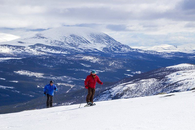
Classic skiing in eastern Jotunheimen
Experienced cross-country skiers and ski tourers can get going as soon as they leave the Valdresflye Scenic Route. Rasletinden is a popular ski mountain in eastern Jotunheimen. Its summit is exactly 2,105 metres high and rewards visitors with a great view of the peaks of the highest Scandinavian mountain range. A relatively easy trail goes from Valdresflye Vandrerhjem – almost 1,400 metres above sea level – to the summit, which is just one reason why it's a favourite with Norwegians. Or you can visit Høgdebrotet a few kilometres further north. It is less frequented, but no less beautiful. There is usually a track in the slope, making it easier for you to go uphill. Flat at first, it gets slightly steeper, then there's a small incline before you get to the top of the 2,226-metre peak. The view is breathtaking: the narrow asphalt strip of the Valdresflye Route (road 51) to the east winds its way through the glistening white blanket, while the peaks of the Jotunheimen mountains rise high into the sky in the other directions. If visibility is good, you can even make out Galdhøpiggen, the highest mountain in Scandinavia.
A bad weather alternative near Randsverk
There will obviously be a few hours or days in spring winter when bad weather prevails, restricting in turn your enjoyment of the mountains. Fortunately, there is a modern and well-developed campsite in Randsverk just below the tree line. The added advantage here is the campsite manager's extensive knowledge of the surrounding area. He readily gives guests tips on activities, speaks excellent German and is only too happy to help organise winter sports equipment, if need be. We recommend Lake Lemonsjøen, a few kilometres from Randsverk, where you can come across up to 120 kilometres of freshly prepared cross-country ski trails nearby, depending on the weather.
The pretty bad weather today has forced us to rethink our plans, so we decide to go on a tour here around the Gråhøe mountain. But the snow filling the track makes every kilometre harder than the one before. We finally get to Dyrtjørni, a secluded frozen forest lake, and begrudgingly decide to cut our tour short and glide back to Lake Lemonsjøen. The alternative wouldn't have been bad either as Fjellstue, the local mountain hut, is known for its excellent food. They serve tasty, traditional Norwegian fare, and around here that means fish and reindeer dishes. Vel bekome!

Snowshoeing at Lemonsjø
A small ski resort with three lifts, Lemonsjø Alpinsenter is not even four kilometres from the campsite in Randsverk. The longest lift goes up 1,400 metres on the east side of Kalvfjellet. It's a steep ride over the treeless fell. There are five ski slopes here. A magnificent terrain for fast descents awaits skiers and freeriders alike, whereas beginners and children can practice in the flatter area. However, snowshoe hikers should head to Trollhøe, a neighbouring peak. You have to go up through a wind-protected valley until the 1,370-metre peak comes into view. There is one last steep ascent, during which the claws of your snowshoes will have to dig into the wind-pressed snow one more time until you get to the top.

Natural attractions on the Sjoa river
There is an unusual attraction just a few kilometres from the Randsverk campsite: the Sjoa river forces its way through a bottleneck a few kilometres south of Randsverk. A sign on road 51 indicates the way to Ridderspranget, 'Knight's leap' in English. It's only a few hundred metres on foot from here to the chasm. The name Ridderspranget comes from a legend claiming that the knight Sigvart crossed a narrow passage eight metres deep and almost two metres wide here, holding a fair damsel in his arms on horseback while fleeing from an adversary. Please don't try this yourself! However, if you hike a little upstream along the gorge, you'll come upon an amazing sight: a secluded pine forest forms the backdrop for a fantastic spectacle as this is where the Sjoa river shows its two faces. The river sometimes roars down over rock formations, causing the water fog to freeze on the rocks in seconds.

The frost discovers its artistic talents by creating amazing sculptures and turning water into ice. Then the river suddenly calms down. It flows sluggishly through deep cauldrons, changing colour from foaming white to iridescent green. You can even see the stones at the bottom. Time after time, the beaten path goes past new vantage points, which sometimes tower over the river like a pulpit in a church. You can even climb down into the canyon at one spot. The panorama framed by the surrounding rocks will be burnt into your memory forever. A masterpiece!