Unfortunately, we don't support your browser (Internet Explorer) anymore, some functionalities could not work. Click here to get information on how to upgrade your browser.
Back to the source.
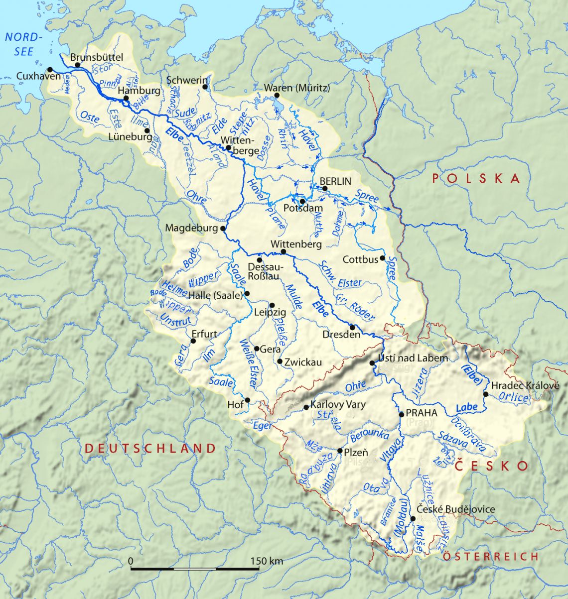
Motorhome tour along the Elbe.
From Cuxhaven to Spindlermühle

Travelogue
The current Cuxhaven was created on December 4, 1872 by merging the villages Ritzebüttel and Cuxhaven. Although Ritzebüttel was historically larger and more important, Cuxhaven became the name for the merged municipality. Ritzebüttel has remained the center of the city. In 1907 the new place received city rights. The city was expanded several times by annexing municipalities. In 1924 Cuxhaven became a city of Hamburg, although it is not adjacent to it at all, Ritzebüttel had been Hamburg for centuries. Cuxhaven was then ceded to Prussia under the Greater Hamburg Act of 1937.
Until 1977, Cuxhaven was a city district. From that year on, the city is the capital of the district of Cuxhaven. The symbol of Cuxhaven is a wooden beacon that stands at the Elbe estuary: the Kugelbake. It is also depicted in the city coat of arms.
Hiking route: Blick zur Kugelbake – Alter Fischereihafen Round trip from Duhnen 4km to be found on Komoot
At the time of publication, Cuxhaven has 16 charging points for electric motorhomes
Hiking route:
Idyllischer Pfad – Entlang der Stör Round trip from Itzehoe 16km on Komoot
Hiking route:
Idyllischer Pfad – Entlang der Stör Round trip from Itzehoe 16km on Komoot
Stade is possibly the oldest city in northern Germany. The first people to settle here date back to 1000 BC. near Stade. In the 8th century BC. a permanent settlement with a harbor emerged. The settlement was sacked by Vikings in 994, and the city was also mentioned in writing for the first time in that year as Stethu . After the extinction of the counts of Stade, the city fell to Hendrik de Leeuw. After his disempowerment in 1180, there was a dispute between the Archbishopric of Bremen and the Welfs who exercised authority over the city. In 1209 Emperor Otto IV granted Stade city rights, staple rights and exemption from the lordship. It is not clear whether and when Stade was a member or was excluded from the Hanseatic League, it was only in 2008 that the Lower Saxon government re-granted the honorary title of Hanseatic City. In 1279 the Stade city council wrote a constitution that would go down in history as the Stader Statutes . From 1361, Stade had the right to enter into alliances, and was thus de facto a free Imperial city. Stade's heyday lasted until the Thirty Years' War. In 1628 Tilly captured the city, which was captured by Swedish troops shortly afterwards. The city remained in Swedish possession until 1636. After a Danish occupation, the Swedes finally conquered the city in 1643 and retained control over it (alongside the Archdiocese of Bremen). Sweden was officially assigned the territories at the Peace of Westphalia.
Map from 1640In the great city fire of May 26, 1659, two-thirds of the city burned to the ground. During the reconstruction, the original street plan was preserved. The Swedish rule ended in 1712. After this came a period when Stade briefly belonged to Denmark, after which it (after a Danish siege) became part of the Electorate of Hanover from 1715.
Until the district reclassification of 1978 it was a landdrostambt or chief town of Regierungsbezirk in Lower Saxony.
From the Swedish era it has been a garrison town until the Von-Goeben-Kaserne, which emerged from the Stade Air Base, was disbanded in 1994.
Stade has 18 charging points for electric motorhomes at the time of publication
Sights
St. Michaelis ChurchChurches
- Saint Catherine's Church
- New Mariadom
- Nikolaiturm
- St.-Petri-Kirche
- Saint James Church
- St. Michaelis Church
Concert halls
The Elbphilharmonie- Elbphilharmonie
- Laeiszhalle
Theatres
- Deutsches Schauspielhaus
- Thalia Theater
- Altonaer Theater
- Ernst Deutsch Theater
- Ohnsorg Theater
- Kammerspiele
- Harburger Theater
- The English Theater of Hamburg
- Komödie Winterhuder Fährhaus
- Theater an der Marschnerstraße
- Allee Theater
Museums
Hamburger Kunsthalle Museum für Kunst und Gewerbe- ComposersQuartier Hamburg , affiliated with:
- Brahms Museum
- Telemann Museum
- Carl Philipp Emanuel Bach Museum
- Johann Adolf Hasse Museum
- Gustav Mahler Museum
- Fanny & Felix Mendelssohn Museum
- Beatlemania Hamburg (2009-2012)
- Hamburger Kunsthalle
- Museum für Kunst und Gewerbe
- Museum für Volkerkunde Hamburg
- Archäologisches Museum Hamburg , formerly called Helms-Museum
- Museum für Hamburgische Geschichte , located in the far west of the beautiful, elongated Planten un Blomen park
- Afghan Museum Hamburg
- Ernst-Barlach-Haus Hamburg in Jenischpark
- Bucerius Art Forum
- Free Academy of Art in Hamburg
- Kunstverein in Hamburg
- Deichtorhallen
- Internationales Haus der Photographie Hamburg in the Deichtorhallen
- Puppy Museum Falkenstein
- Das Auswanderer Museum BallinStadt
- International Maritime Museum Hamburg
- Maritime Museum Museumshafen Oevelgönne
- U-Boat Museum U-434
- museum ship Cap San Diego
Miscellaneous
Speicherstadt- Speicherstadt and the Kontorhausviertel with the Chilehaus (UNESCO World Heritage)
- Hamburg Hauptbahnhof
- St. Pauli-Landungsbrücken passenger terminal
- St. Pauli Elb Tunnel
- Walking route: Speicherstadt – Jan Fedder Promenade Round trip from Reeperbahn 14 km to be found on Komoot
- Hamburg has 682 charging points for electric motorhomes at the time of publication
Drage is a municipality in the German state of Lower Saxony. The municipality is part of the Samtgemeinde Elbmarsch in the Landkreis Harburg. Drage (Elbe) has 4,235 inhabitants.
Hiking route:
Biberland – Sitzliege Round trip from Schnakenbek 11 km to be found on KomootDrage is a municipality in the German state of Lower Saxony. The municipality is part of the Samtgemeinde Elbmarsch in the Landkreis Harburg. Drage (Elbe) has 4,235 inhabitants.
Hiking route:
Biberland – Sitzliege Round trip from Schnakenbek 11 km to be found on KomootHiking route: Bleckede, Schloß – Blick vom Deich Round trip from Brackede 7.5 km to be found on Komoot
Lauenburg has 6 charging points for electric motorhomes at the time of publication
Hiking route: Bleckede, Schloß – Blick vom Deich Round trip from Brackede 7.5 km to be found on Komoot
Lauenburg has 6 charging points for electric motorhomes at the time of publication
Culture
From May 1 to September 30, a city tour of Hitzacker (Elbe) is offered daily at 6:00 PM. Here you have the opportunity to get to know the charming island town on a one-hour city walk. Meeting point: Market Square Hitzacker, Price: € 3.00 per person
section A F – left of the Elbe – approx. 300 m from the Elberadweg
Hitzacker (Lower Saxony/D)
If you want to know how people lived then, how they made their tools, where they lived, how they dressed, what they ate, what dangers threatened them and how archaeologists know all this, just step in. We will show you how to knock fire out of the stone, how to grind grain, how to burn ceramic pots or how to drive the dugout. Find summer and fall herbs that brought food and healing. Search the past and the future in the wickerwork labyrinth. Put yourself in the role of the family hunter and supplier on the archery range. If you want to take a closer look, book one of our action programs, which says "Touch and join" One click will take you back more than 3000 years to the Bronze Age. The inhabitants of the small village on the banks of the river are already waiting for you! The museum is also accessible to people with walking disabilities. Since 2015 there is a bicycle station at the entrance with:
- 30 bicycle sheds, 10 of which are covered
- Charging station for five e-bikes at the same time
- Free luggage storage in a luggage room
- Sanitary facilities in the same building
- Accommodation for guests
- Offer of route maps and information brochures in the store
Hiking trail: Hiddo-Steg – Zwischen Elbe und Jeetzel Round trip from Hitzacker (Elbe) 7.6 km on Komoot
The Hitzacker area has 2 charging points for electric motorhomes at the time of publication
Schnackenburg is a municipality in the German state of Lower Saxony. The municipality is part of the Samtgemeinde Gartow in the Landkreis Lüchow-Dannenberg. Schnackenburg has 531 inhabitants.
Hiking route: Aussichtsturm Schwedenschanze – Castellum Hohbuoki Round trip from Vietze 6.66 km to be found on Komoot
Hiking route: Havelberger Dom – Stadtkanal Round trip from Havelberg 3.12 km on Komoot
Havelberg has 1 charging point for electric motorhomes at the time of publication
Hiking route: Havelberger Dom – Stadtkanal Round trip from Havelberg 3.12 km on Komoot
Havelberg has 1 charging point for electric motorhomes at the time of publication
Hiking route: Neustädter Tor (Stadttor) – Hafen von Tangermünde Round trip from Tangermünde 4 km to be found on Komoot
Tangermünde has 4 charging points for electric motorhomes at the time of publication
Hiking route: Neustädter Tor (Stadttor) – Hafen von Tangermünde Round trip from Tangermünde 4 km to be found on Komoot
Tangermünde has 4 charging points for electric motorhomes at the time of publication
Hiking route: Beach Niegripper See – Ev. Kreuz Kirche Niegripp Round trip from Niegripp 8.07 km to be found on Komoot
Hiking route: Beach Niegripper See – Ev. Kreuz Kirche Niegripp Round trip from Niegripp 8.07 km to be found on Komoot
Magdeburg was one of the most important cities of the Holy Roman Empire in the Middle Ages. Emperor Otto I had his imperial palace there and founded a bishopric there, which during his lifetime was elevated to the Archdiocese of Magdeburg and which was an important point of support against the pagan Slavs. After his death in 973 Otto I was interred in the cathedral. This church was reduced to ashes during a city fire in 1207, which also destroyed the Palatinate, and was replaced by the current, first Gothic church in Germany.
Magdeburg received city rights in 1035. Dozens of towns east of the Elbe would later receive city rights that were grafted onto Magdeburg's: Magdeburg's city rights were, together with that of Lübeck, the most influential in Germany. In the thirteenth century, the city joined the Hanseatic League. The city is located just east of a city that has been around since about 5000 BC. exploited by man and because of its "black earth" very fertile agricultural area, the Magdeburger Börde . This, in combination with the staple rights granted to the city, will certainly have contributed to Magdeburg's nickname "the granary of the Hanse".
Magdeburg was conquered in 1631 during the Thirty Years' War after a siege by the Imperial general Johan t'Serclaes of Tilly, during which the city went up in flames and most of the 30,000 inhabitants lost their lives.
Otto von Guericke was mayor of Magdeburg from 1646 to 1681. He was also a renowned physicist, who in 1657 conducted the famous experiment of the Magdeburg hemispheres, which proved the existence of vacuum and air pressure.
During the Second World War, the city was again almost completely destroyed. After the last world war, the city belonged to the GDR from 1949-1990 and relatively little of the original cityscape was restored. The cathedral, however, was restored.
Magdeburg is now making considerable progress. There are buildings by famous architects, such as the Hundertwasser project 'Grüne Zitadelle'.
Sights
Museums
- Magdeburg Art Museum in the Kloster Unser Lieben Frauen with outdoor collection of sculptures in Skulpturenpark Magdeburg
Theatres
- Magdeburg Puppet Theater in the Buckau . district
Hiking route: Waldpädagogisches Zentrum – Ehle Round trip from Magdeburg Herrenkrug 14.4 km on Komoot
Maagedenburg has 37 charging points for electric motorhomes at the time of publication
Sights
- St. John's Church
- Saint James Church
- Hiking route: Natur – Wasserstellen Round trip from Pretzien 9.64 km to be found on Komoot
- At the time of publication, Schönebeck has 4 charging points for electric motorhomes
Sights
- St. John's Church
- Saint James Church
- Hiking route: Natur – Wasserstellen Round trip from Pretzien 9.64 km to be found on Komoot
- At the time of publication, Schönebeck has 4 charging points for electric motorhomes
Culture
Bauhaus-DessauFounded in Weimar in 1919 by Walter Gropius, the Bauhaus was Germany's most famous art and design institution of classical modernism. The works created at the Bauhaus between 1919 and 1933 influenced the understanding of architecture and design worldwide. In 1925/26, the Bauhaus building in Dessau was built to designs by Walter Gropius, after the school left its Weimar headquarters for political reasons. The expansive ensemble of glass, steel and concrete, in which each element is integrated without attached effects, corresponds to the idea of its founder: form obeys function.
With their unique creative atmosphere, the studio wing, workshops, vocational school and stage clearly embody the Bauhaus idea. Today, the building is home to the Bauhaus Dessau Foundation and is more than just a school or museum. It is a place of design, research and education that provides space for members of design disciplines to engage with the important topics of urban development today. Since 1999, the Bauhauskolleg has been an interdisciplinary postgraduate program for designers from all over the world. The Bauhaus offers guided tours and excursions to the other Bauhaus buildings in Dessau, exhibitions can be visited and the Bauhaus stage is used for cultural events.
Just a 5-minute walk away, the small settlement of the MEISTERHÄUSER for the Bauhaus teachers was built at the same time as the Bauhaus building. A visit to the living quarters of Paul Klee, Wassily Kandinsky or Oskar Schlemmer will give you a good impression of the ideal of modern life at the time. The Gropius House and the semi-detached house next door were destroyed during the war, rebuilt in recent years and reopened to the public in 2014. Once in Dessau, you must also have seen the Törten estate, the Kornhaus excursion restaurant, the former employment office and the other buildings of the Bauhaus architects in Dessau.
Hiking route: Stillgewässer an der Elbe-Aue – Versuchsstraße Round trip from Roßlau 5.17 km to be found in Komoot.
Dessau-Rosslau has 16 charging points for electric motorhomes at the time of publication
Culture
asisi Panorama Luther
Immerse yourself in the Wittenberg of the Reformation. In his monumental work LUTHER 1517, Yadegar Asisi describes the groundbreaking events here on the spot. In addition to history and stories about Luther and his comrades in arms, you will experience the daily life of citizens, farmers and students, the life of the clergy and the nobility. Embedded in a day-night rhythm and accompanied by specially composed music, you will experience on 15 x 75 meters how a new era broke into the ground. The panorama can be seen in Lutherstadt Wittenberg until October 2021.
Hiking route: Schloss Wittenberg – Denkmal Martin Luther Round trip from Lutherstadt Wittenberg 7.11 km on Komoot.
Luther Wittenberg has 9 charging points for electric motorhomes at the time of publication
Zahna Elster has 1 charging point for electric campers at the time of publication
Zahna Elster has 1 charging point for electric campers at the time of publication
Hiking route: Burg Klöden Round trip from Klöden 12.4 km to be found on Komoot
Hiking route: Burg Klöden Round trip from Klöden 12.4 km to be found on Komoot
Beilrode is a municipality and place in the German state of Saxony, and is part of the Nordsachsen district. Beilrode has 4,122 inhabitants
Since January 1, 2011, the former independent municipality of Rosenfeld has been part of Beilrode
The nearby Torgau has 7 charging points for electric motorhomes at the time of publication
The first documented settlement was on a sand island in the River Elbe. The island was a safe crossing point and was protected by the nearby castle. Excavations show that as early as 600 BC. people were buried.
On April 24, 1547, the Battle of Mühlberg took place in which Charles V won an important victory and the Duke of Saxony was captured. In the town hall in Veere there is a gilded cup on which this is depicted.
In August 2002, Mühlberg was evacuated because of the high water levels in Central Europe. On May 24, 2010, Whit Monday, the city was hit by another natural disaster; first a heavy hailstorm, then a tornado followed. More than 300 houses were badly damaged and the church tower of the Marienstern Monastery fell.
There are two mills in Mühlberg, a flour mill from 1834 and a flour mill from 1894
Struggling
From September 1939 a prisoner of war camp, Stalag IV-B, was located here. About 300,000 prisoners of different nationalities were imprisoned, of whom about 3,000 died in the camp (mostly Russians). They were housed in barracks for 800 men. As the Red Army approached, 200 men were transported by the Germans to Böhmisch Kamnitz in Sudetenland. Fifty men did not survive that journey. On April 23, 1945, the remaining prisoners were liberated by the Red Army, including 1200 Dutchmen. From September 1945 to November 1948 the camp was used by the Soviet intelligence service NKVD. It became 'Speziallager Nr. 1 Muhlberg'. About 6,700 of their prisoners died of starvation, disease or exhaustion and were buried in mass graves outside the camp. A monument commemorates all the victims.
Hiking route: Hospiz – Kloster Marienstern Round trip from Mühlberg/Elbe 6.56 km to be found on Komoot
Riesa is a municipality and place in the German state of Saxony, located on the Elbe in the Landkreis Meißen. The municipality has 29,256 inhabitants
The city is best known for the steel industry and as a sports city with many sporting events. Furthermore, Riesa is the seat of a factory of typical German noodles, which is named after the city. This factory has a giant as its logo. According to a story made up in the 18th century, Riesa was founded by a giant. In reality, the city originated at a medieval monastery near a Slavic settlement at a river estuary. The name comes from the Sorbian designation riezowe for a valley at a river mouth.
Since 1994, Riesa has had Große Kreisstadt status in the state of Saxony.
Sights
- The Stadtmuseum is located in Haus am Poppitzer Platz .
- Jahnishausen Palace in the Jahnishausen district.
- Animal park with monastery.
Churches
- Church of St. Marien
- Trinity Church
- Riesa-Gröba Church
Other places of interest
- Town hall created by the renovation of an old castle, which in turn was created in the Middle Ages by the renovation of a monastery.
- Zunftbaum ( Gildeboom )
- public observatory
- Largest iron statue in Europe Immendorffs Elbquelle
- Noodle Museum
- Hiking route: Riesa – Klosterkirche St. Marien Round trip from Riesa 8.97 km to be found on Komoot.
- Riesa has 12 charging points for electric motorhomes at the time of publication
Meißen is a municipality and place 25 km northwest of Dresden, in the German state of Saxony. It is the Kreisstadt of the Landkreis Meißen. The city has 28,231 inhabitants
The settlement was formed at a bend in the Elbe and is first mentioned at the end of the 9th century. A Gothic cathedral arose in the thirteenth century on the steep castle hill, which was embellished with two iconic towers in the nineteenth century. At the end of the fifteenth century, the Albrechtsburg Castle was built next to it, the first castle in Germany not built as a fortress, intended as a residence for the Dukes of Saxony.
In 1710 Johann Friedrich Böttger started manufacturing the famous Meissen porcelain in Albrechtsburg, which made the name Meissen more famous than anything else.
Hiking trail: Blick auf Meißen – Weinberg Schloss Proschwitz Round trip from Meißen 13.7 km on Komoot.
At the time of publication, Meissen has 8 charging points for electric motorhomes
Sights
Churches
- Frauenkirche (reconstruction completed in 2005)
- Kathedrale Sankt Trinitatis (former Katholische Hofkirche )
- Dreikonigskirche
Palaces
Residence Castle- Zwinger
- Residence Castle
- Coselpalais
- Taschenberg Palace
- Jagerhof
- Kurlanderpalais
- Japanese Palais
- Castle Pillnitz
- Landhaus
Museums
Gemäldegalerie Alte Meister Albertinum- Staatliche Kunstsammlungen Dresden including
- the Gemäldegalerie Alte Meister
- Porzellansammlung
- Rüstkammer (armor, pistols, etc.)
- Mathematical-Physikalischer Salon (a collection of instruments, such as clocks, globes, astronomical instruments)
- the Grünes Gewölbe (the treasury of the Saxon electors)
- the Albertinum ( Sculpturenhalle and Galerie Neue Meister )
- the Kunsthalle im Lipsius Bau
- Deutsche Hygiene Museum
- Landesmuseum für Vorgeschichte
- Staatliche Naturhistorische Sammlungen Dresden
- Museum für Volkerkunde Dresden
- Universitätssammlung Kunst + Technik
- Johanneum Traffic Museum Dresden
- Museums of the City of Dresden
- Carl-Maria-von-Weber-Museum
- Military History Museum of the Bundeswehr
- Botanical Garden of the Technical University of Dresden
- Richard-Wagner-Stätten , in Graupa near Dresden
Theater and Opera
semperoper- Semperoper ( Sachsische Staatsoper )
- Schauspielhaus am Zwinger
Squares and streets
- Altmarkt , important square in the Old Town with the Kreuzkirche
- Neumarkt reconstructed square with the Frauenkirche . in the middle
- Bruhlsche Terrasse
Bridges
- Albertbrucke
- Loschwitzer Brücke , nicknamed the Blaues Wunder
Other places of interest
Cigarette Factory Yenidze- The Fürstenzug , probably the largest tile panel in the world depicting all the princes of the House of Wettin up to 1918
- Sächsisches Ständehaus
- Yenidze Cigarette Factory
- Großer Garten (city park)
- Gläserne Manufaktur (Volkswagen Glass Factory)
- Statue of Augustus the Strong ( Goldener Reiter )
- Pfunds Molkerei
- The only mountain ropeway in the world (connection between the Loschwitz and Oberloschwitz districts)
- Steamships on the Elbe
- Ernemann Turm' (former camera factory and now technical museum)
- Dresden City Hall
- Blockhaus
- Saxony Chancellery
World Heritage List
An 18 km long section of the Elbe Valley, including part of Dresden, was declared a World Heritage Site by UNESCO in July 2004. Due to plans to build the Waldschlösschen Bridge, it was red-listed two years later. On June 25, 2009, the Elbe Valley was again removed from the World Heritage List, because the city considered the construction of the bridge more important than its place on this list. The traffic between the "Altstadt" and the "Neustadt" always went via the monumental bridge "das blaue Wunder". This bridge became overloaded due to the increasing amount of traffic. The discussion on whether to remain on the World Heritage List and whether it would be better for the city's infrastructure to build a new bridge could often be attended "live" on the street. The city's residents often felt that Dresden has so much appeal that a UNESCO listing would not be necessary. The Waldschlösschen Bridge was put into use in 2013.
Hiking route: Wolfshügel – Schwesternquelle Round trip from Waldschlösschenviertel 7.75 km to be found on Komoot.
Dresden has 134 charging points for electric motorhomes at the time of publication
Hiking route: Liebethaler Grund – Stiege in der Lohmener Klamm Round trip from Jessen 10.4 km to be found on Komoot.
Pirna has 12 charging points for electric motorhomes at the time of publication
Hiking route: Liebethaler Grund – Stiege in der Lohmener Klamm Round trip from Jessen 10.4 km to be found on Komoot.
Pirna has 12 charging points for electric motorhomes at the time of publication
Bad Schandau is a municipality and place in the German state of Saxony, and is part of the Landkreis Sächsische Schweiz-Osterzgebirge. Bad Schandau has 3,511 inhabitants
The historic Kirnitzschtalbahn departs from Bad Schandau.
Hiking route: Schrammsteintor – Schrammsteinaussicht Round trip from Ostrau 9.71 km on Komoot.
Bad Schandau has 3 charging points for electric motorhomes at the time of publication
The first written mention of the village dates back to 1579. Dolní Žleb used to belong to the Děčín estate of the Thun family, most inhabitants were German until 1945.
Initially there was a pub in the village, later houses and a sawmill were built. In 1752 there was a school, which was demolished in 1789-1791 by order of the Count of Děčín, who then built a new school, which was used for education until 1902. At that time there was also a gendarmerie, post office, customs office and municipal office. A button factory was built in Dolní Žleb in 1774, and in the first half of the 20th century there was a Tamany factory producing ointments, tinctures and extracts.
After 1945, the original German population was gradually expelled. As a result, the part of the village called Globt (Czech: Klopoty), which extended to the state border formed by the Klopotský stream (Gelobtbach), was destroyed by the army in 1956 as part of the border area. The village of Dolní Žleb itself disappeared in 1980 when it was added to the town of Děčín.
Culture
Aquapark Decin section P - right of the Elbe - approx. 200 m from the Elberadweg (Ustecky kraj/CZ) Water world with horseshoe pool and real waves, counter current, relaxation and outdoor pool.
Hiking route: Wunderschöne Aussicht – Edmundsklamm (Silent Klamm) Round trip from Schöna 17.3 km to be found on Komoot
Neštědice (German: Nestersitz) is a part of the municipality of Povrly in the Ústí nad Labem district. It is located in the west of Povrly. The Praha-Děčín railway line and the I/62 road run through it. In 2011, 633 people lived here permanently.
Hiking route: Masaryk-Schleuse – Hrad Střekov Round trip from Ústí nad Labem hlavní nádraží 10.9 km to be found on Komoot
Culture
An otherwise cozy and pleasant theater hall, the Karel Hynek Mácha Stone Theater in Litoměřice underwent a major renovation in the 1980s and 1990s; the hall has no regular theater and no permanent professional ensemble, and is used for touring theatre, amateur artistic activities, concerts and other social purposes
Litoměřice House of Culture, started construction in the 1980s, completed in the 1990s, arguably the most important center of living culture in the city. It replaces the original inadequate building "Na hrádku" in the former castle of Litoměřice. Concerts, balls, courses, seminars and other social events are organized here.
The Museum of History in Litoměřice, an exposition on the history of the city and the entire Litoměřice region
The North Bohemian Gallery of Fine Arts in Litoměřice, an exhibition space with regular exhibitions of important Czech and foreign artists, a permanent exhibition of naive painting, the largest exhibition of this type of art in the Czech Republic, the gallery also includes the Museum of the Diocese of Litoměřice
Karel Hynek Mácha Memorial Site - KH Mácha's memorial on the eastern slope of Dómský Hill
Zahrada Čech exhibition area, a place for business, social and cultural life all year round, various cultural events take place here during individual exhibitions, especially concerts of popular music artists, rallies of historic motor vehicles and other accompanying events
The Litoměřice Organ Summer Music Festival takes place in St. Stephen's Cathedral
The existence of several children's or youth choirs, the Litoměřice Notation Choir Festival
The Litoměřice Vintage Festival, a traditional cultural and social event, usually takes place on the penultimate weekend of September in Mírovo Square and Střelecký ostrov
Litoměřice Underground, an exhibition of cellars and catacombs related to the history of the city (city lapidarium)
Observation terrace in the Kalich building (Litoměřice Town Hall) on Mírové náměstí (Peace Square)
The headquarters of the Board of the Protected Landscape Area of the Bohemian Central Highlands, a specialized department of the state nature conservation (located in the protected bastion of the original Litoměřice walls)
Karel Hynek Mácha Municipal Library on Mírov Square
Cinema Máj from Litoměřice, permanently in operation, in summer also a summer cinema on Střelecký ostrov.
Walking route: Radobýl – Marktplatz von Litoměřice Round trip from Litoměřice město 10.1 km to be found on Komoot.
This place has 2 charging points for electric motorhomes at the time of publication
The first written mention of the village ( Radcicz ) refers to the year 1295. As can be seen from this example, the name was originally Radčice , ie a settlement of the Radek people (from the personal name Radek). Until the end of the eighties of the twentieth century, Račice belonged to the local parts of the town of Štětí, since July 1, 1990 again an independent village
Hiking route: Bergtour Rip – Aussichtspunkt Round trip from Roudnice nad Labem 14.7 km on Komoot
- Mělník Castle, built in Baroque style on an elevated place above the river, originally a medieval castle, from which the vaulted hall in the west wing and the gate from the 15th century have been preserved. The castle originally served as the seat of dowager Czech queens. After 1550 a renaissance north wing with loggias was added, after 1690 a south wing with arcades was added and after 1925 a wine bar with a terrace was adapted.
- The town hall, originally mayor from 1398, the town hall from 1449, rebuilt after a fire in 1793 and again in 1889 and 1941.
- Gothic three-aisled church of St. Peter and Paul, originally Romanesque from the 11th century, of which the lower part of the tower has been preserved. Rebuilt in 1480-1488 (vault in the nave, tower) and after 1516 (new rectory, vault of the main nave and crypt). In the choir is a sanctuary from 1530 and a renaissance pew. In the sacristy is a tombstone of provost Jan van Landštejn from 1389.
- Bone house in the crypt under the presbytery of the St. Petra a Pavla, one of the largest in the Czech Republic, is open to the public.
- Mělník underground, connects the cellars under the entire historic core of the city; part of the town hall cellars with the widest well in the Czech Republic (4.5 m in diameter) below the square is open to the public.
- Churchyard Church of St. Ludmila from 1585, rebuilt in 1683.
- Capuchin Church of the Fourteen Holy Helpers with a former monastery
- Renaissance and Baroque houses in the square and in Palackého Street.
- Prague Gate (around 1500) and the remains of the walls with a bastion and a water tower.
- On the vantage point behind the north wing of the castle is a statue of Charles IV by Joseph Max from 1878.
- Masaryk House of Culture, an important and well-preserved functionalist theater building completed in 1936.
- A system of vineyards that extend into the city center (below the castle) and also surround the city in a discontinuous strip from north to southeast and include some minor architecture (vineyard houses, sounds, presses, retaining walls), which is partially protected as a monument
- Hiking route: Rathaus Melnik mit Brunnen Round trip from Mělník 2.44 km to be found on Komoot
- Church of St. Alexander
- Lobkowicz . Castle
- Tomb of František Palacký at the cemetery in Lobkovice
- Church of the Assumption of the Virgin Mary
- The first Czech carbide electrochemical factory, Bohdan Kasper, founded in 1899 in Palackého Street by rebuilding part of the mill, the building has been preserved in good condition, including the chimney, engine room and channels. It is partially used. [6]
- Area Spolany Neratovice. VB Goldberg was the first to establish a soap, candle and stearin factory here in 1898 and later the production of hard metal and ammonia water was added. After the collapse and transition to food production in 1939, the property was bought by the famous Association for Chemical and Metallurgical Production and massive modifications of the property followed. Among other things, there was a unique construction of a shed with a gabled shell roof in the form of a hyperbolic paraboloid or a hydroelectric power station, part of the Lobkowicz lock. In 1950 spolana Neratovice was founded after the nationalization of the association spolana. In addition to the production of man-made fibers at that time, the company began to produce chlorine, hydrochloric acid or cellophane, and since 1975 also PVC. Today the architecturally very valuable and still functional complex is owned by the Polish PKN Orlen.
- Lobkovice lock and hydroelectric power station. The lock was built between 1914 and 1922, the current appearance of the single-aisled lock chamber dates from 1977. In 1927 a movable weir was built in a short trench about 300 meters below the original fixed weir, which caused water to swell in the mill race . Between 1942 and 1947, the Association for Chemical and Metallurgical Production built a hydroelectric power station with two vertical Kaplan turbines with a capacity of 1.18 MW from the Pardubice plant of Josef Prokop Sons.
- Neratovice railway station, built in 1872 within the Turnov-Kralupy Railway.
- Realized works from the symposium Revived City of Neratovice '97 :
- Equestrian statue Jan Novotný (1999)
- Stones in the Forest Dagmar Šubrtová (2000)
- Sandstone sculpture I LOVE Lenka Klodová (2001)
- Kurt Gebauer's Stone Book in Lobkovice (2018)
- This place has 1 charging point for electric motorhomes
Sights
The symbol of the city are brick walls with prismatic bastions. Originally, with a kidney-shaped ground plan, the city was surrounded by a line of two walls, white marlstone and red brick, along with two moats (preserved to this day as small and large ramparts). Today only the remains of the walls remain, the longest part in the east, near which the old deanery is located, was romantically reconstructed at the beginning of the 20th century, other remains of the walls are in Hradební Street .
The dominant feature of the town is the Gothic brick Church of St. Giles which stands in the church square. Originally it had two towers, but one of them was demolished after the fire, so the remaining tower has a special position outside the axis of the temple. This church, together with the preserved buildings of the Nymburk fortifications, is a unique example of Brick Gothic (originally Northern German) in the Czech lands. In tyršova street there is a Gothic chapel of St. John of Nepomuk, which is the only remnant of the former monastery church of the Assumption of the Virgin Mary of the Rosary and to which the functionalist Hálka Theater was added. Southwest of the historic city center is the Renaissance Church of St. George and in the park of Dr. Antonín Brzorád the Functionalist Hus Congregation and the Neo-Renaissance Evangelical Church.
The dominant feature of the main square of the Přemyslids is the rare Renaissance town hall, there is also a plague column. An interesting technical monument is the nearby Turkish Tower, a former municipal aqueduct from 1597. One of the city's most interesting modern buildings is the architecturally significant purist crematorium of Bedřich Feuerstein or the functionalist Löwit Villa. On the contrary, a witness of antiquity is the preserved prehistoric cairn in Na Příkopě Street.
In addition to the walls, the city is also dominated by a road bridge (cultural monument), which connects the city center with the part called Zálabí. The bridge over the Elbe was built between 1912 and 1913 by architect František Roith. It consists of three reinforced concrete arches with spans of 35, 40 and 35 meters, resting on concrete pillars. The granite cladding of the pillars is decorated with shields with the motif of Czech lions.
The town has a mixed chamber choir Vox Nymburgensis. The finals of the Mateřinka festival are also held annually in Nymburk. The final of the Mateřinka festival is also held annually in Nymburk.
Since 2004, the music festival Přístavní slavnosti has been held annually in Nymburk.
Hiking trail: Blumen Uhr – Blick auf die Schleuse Round trip from Poděbrady III 5.72 km on Komoot.
This place has 1 charging point for electric motorhomes
Sights
The historic center has been declared a protected nature reserve since 1989. It has retained its original medieval floor plan. On Charles Square are Baroque houses, the Neo-Renaissance town hall, the plague column and the fountain. The southwestern part consists of a former Jewish ghetto with a synagogue from the 17th century. The center is surrounded by a double belt of walls (partially preserved) with a parkan. The front part of the city fortifications on the right bank of the Elbe is called Práchovna. Dating back to the 15th century, it later served as a gunpowder store.
The dominant feature of the town is the Church of St. Bartholomew, originally early Gothic from the 2nd half of the 13th century. At the end of the 14th century, Petr Parléř took part in its reconstruction into a Gothic cathedral. It is a national cultural monument.
Other churches in the town are the Baroque Church of St. Vitus on Zálabí (originally Gothic from the 14th century), the Church of the Holy Trinity with a Capuchin Monastery, the Church of St. John the Baptist now used by the Orthodox Church, the Church of the Czechoslovak Church from 1932 and the ruins of the Church of All Saints at the train station.
Kolín Synagogue in Na Hradbách StreetWest of the city center is the second oldest and second largest Jewish cemetery in Bohemia dating from 1418 with over 2600 headstones. There is also a tombstone of the son of the famous Prague Rabbi Löw from 1599. On Zálabí there is a new Jewish cemetery, founded at the end of the 19th century. It was significantly damaged during the Second World War and during the construction of the bridge over the Elbe.
In front of the gymnasium building there is a restored monument to Tomáš Garrigue Masaryk since 1990. It was found in 1989 under coal and old tires in the basement of Nelahozeves Castle along with Břetislav Benda's 1946 TGM monument to Brandýs nad Labem.
The restored Kolínská řepařská drážka has been in use since 2007. Along this path you can pay for a ride around Kolín. Today it is about four kilometers long. A well-known Kolín building is also the now-defunct Kolín waterworks and also the well-known "sixteen-storey" among the locals, the tallest building in Kolín, on the ground floor of which there is a pharmacy. In addition, there are architecturally valuable buildings from the interwar period of the gymnasium (originally a business academy) or the Cologne station.
Water tower in KolínCastle brewery with malthouse in KolínSugar factory in Kolín by painter Zdeněk RykrMill Radimského on ZálabíFootbridge to Kmoch IslandFrom the second half of the 19th century, the city developed dynamically as an industrial center of the Central Elbe, making it the largest city in eastern Central Bohemia. A number of industrial monuments from this period have been preserved today:[14]
- The castle brewery with a malt house in the area of the castle of Kolín, first mentioned in 1531, rebuilt by the prominent economic expert František Horský of Horskyfeld between 1865 and 1873. At present, some buildings have been repaired, others have been senselessly demolished by the city.
- Radimského or the so-called Podskalský mill on the Podskalské embankment in Zálabí, first mentioned in 1285, reconstructions in 1870 and 1923. The mill was operated from 1851 by the famous Kolín Radimský family, of which important politicians and artists were members. The most famous representative is the painter Václav Radimský. The mill is currently preserved, but dilapidated.
- Formánkův mill with machine shop and foundry in Rybářská Street, first mentioned in 1285, reconstruction in 1879. The owner was, among others, Josef Formánek, mayor of Kolín from 1868 to 1890. Today it is used as warehouses and workshops for smaller companies. The area is currently derelict.
- Kolín coffee substitute factory, famous as the so-called Kolín chicory, built in 1894 by the well-known politician and architect Čeněk Křička. Later she switched to candy owl. A silo was added in 1987. It is still functional today with exceptionally preserved Art Nouveau elements and a 35 meter high brick chimney.
- Vavruška's soft drink factory. The company was originally founded as an oil press by Ignác Selikovský in 1856, taken over by the Fischer brothers in 1861. In 1912, Otakar Vavruška bought the building and started producing lemonades here, which still takes place here under the Koli brand. Extensions were made between 1951 and 1953, but most of the buildings have been preserved in their condition after the fire of 1877.
- A joint sugar factory, joint-stock company, built in 1864 by the Pardubice builder Karel Krátký east of the station. Most of the buildings were demolished in 2010. To this day, only a small production building and a building for civil servants have survived.
- Factory for confectionery and chocolate goods Kolinea in the street Na pobřežní east of the center, founded in 1896 by Karel Cyvín, expansion between 1940 and 1942. Production ended in the 50s.
- Nameless factory for the production of fertilizer and lučebniny on Pražská Street, the so-called Lučebka. Founded in 1871. Continuous extensions. Still functional today, it produces products of construction and industrial chemistry.
- Czech joint stock company for the refining of kerosene in ovčárecka street in Zálabí, or Petrolka, since 1925 part of vacuum oil company, later KORAMO. Built between 1902 and 1903, modernized between 1929 and 1939, restored in 1945 after air raids during World War II. Still functional and preserved, part of the Unipetrol concern.
- Limited liability company for the processing of potassium lye in havlíčkova street, the so-called Draslovka. Founded between 1907 and 1908, rebuilt in 1935, restored after air raids in 1947. Still functional and preserved, produces and processes mainly hydrogen cyanide. There are also two valuable brick factory chimneys, 64 and 35 meters high. Between the draslovka area and the railway, the original building of the so-called new distillery from 1871 is also well preserved.
- Wiesnerova strojírna, founded between 1870 and 1875 in Rybářská Street No. 56 next to the Kolín stop. It mainly produced equipment for sugar mills. It ceased to exist in 1936, and at the beginning of the 1950s the production of kilns was moved here. Ovens are still produced here under the brand name Elektroteplo. Particularly preserved is the entrance building with decorative elements on the facade, located in a picturesque corner next to the branch of the river Elbe.
- Masaryk bridge, lock and hydroelectric power station. Bridge built between 1924 and 1927, power plant in 1931. The whole complex is still functional, the hydroelectric power plant was reconstructed between 2011 and 2012 and equipped with new technology, including turbines.
- Footbridge to Kmoch Island, built in 1885. The stone pillars were made by the Kolín builder Josef Sklenář, the iron structure was supplied by the Vojtěšská smelter in Kladno. Still fully functional today.
- ESSO Power Plant in Tovární Street in Zálabí, built by architect Jaroslav Fragner in 1932. A very valuable functionalist building, after 1948 it was converted into a heating plant. It is still functional today. The factory replaced the original Křižík steam power plant near the train station from 1911, of which only the small building No. 271 on Pod Hroby Street has survived to this day.
In addition to the above mentioned, there are a number of other preserved areas in Kolín, e.g. Stanislav Orl chemical factory in Brankovická street in Zálabí, Fram car factory in Ovčárecké street in Zálabí, Prchal-Ericcson/Tesla- complex or the Josef and Prokop Červinkova ironworks in Havlíčkova Street, the Veletovského brickworks in Plynárenská Street and the Kašparides brothers' factory in Polepská Street. However, its potentially very attractive industrial heritage is still not being systematically developed, despite its abundance. On the contrary, some demolition works have already taken place, in addition to some of the buildings of the castle brewery (fermentation room, barley soil), the valuable buildings of the JL Bayer printing house were demolished in 2007, including buildings from the end of the 19th century and from the 1920s. of the next century. Futurum department store was built in its place, but designed without any connection to the history or architecture of the famous company. [14]
In addition to two Jewish cemeteries, there is a municipal cemetery (1880) and an evangelical cemetery in the Zálabí district. Another public cemetery is the cemetery in Sendražice and the columbarium in the church of the Czechoslovak Hussite Church.
This place has four charging points for electric motorhomes
Cultural Monuments
.Church of St. Bartholomew, rebuilt at the beginning of the 16th centuryNational Cultural Monuments:
- Castle Pardubice with fortifications
- Reverent area Chateau
- Pardubice Crematorium
- Winternitz automatic mills
Selected cultural monuments in Pardubice:
- Village house No. 49
- House U Jonáše
- Vienna House
- Church of the Annunciation of the Virgin Mary
- Church of St. Bartholomew
- Green Gate
- City Theatre
- Industrial Museum
- Grand hotel and community center
- Church of St. John the Baptist
- New Jewish Cemetery
- Machoň's Passage
- Pardubice Train Station
- Church of Our Lady of Sorrows
- Počápelský water canal
- Stone Villa
- Villa of Viktor Kříž
- District Court
- This place has 12 charging points for electric motorhomes at the time of publication
Masaryk Square, 2007
The city is famous for its modern construction, and has even been given the name Salon of the Republic . The beginning of this intensive work by leading architects is by Jan Kotěra, the author of the Art Nouveau building of the museum. After the First World War, Josef Gočár became the main architect of the city, to whom he owes the creation of many buildings in the new part of the city, including the construction of the railway directorate on Ulrich Square (today the regional directorate of the Police of the Czech Republic), the modification of the Masaryk Square with a monument to the President, the school complex on the Tyl embankment (the current JK Tyl Grammar School and the adjacent former primary school), the buildings of the Congregational Buildings of the Priest Ambrose Czechoslovak Hussite Church, Municipal Building on CSA Avenue.
Festivals
- Theater of the European Regions – the pinnacle of the theater season
- Waiting for Wenceslas – "Festival of Big Little Theaters"
- Jazz goes to town – the most prestigious of domestic and European jazz festivals
- Music Forum – festival of modern classical music
- Majáles – student festival
- Rock for People – one of the biggest music festivals in the Czech Republic
- Truckfest – the largest international gathering of road hauliers with a graceful ride through the city
- Gastro Hradec – national championship of chefs and pastry chefs and show of culinary and confectionery art,
- Febiofest – film festival, Cinestar organizes its Echoes in Hradec
- Entrée to Dance – festival of dance and movement creation
- Meeting with Folklore – a festival organized by the local folklore ensemble Kvítek
- Hradecká Odette – dance festival and international dance competition
- CSM - National Youth Meeting (8-12 August 2022)
- Hiking route: Hradec Králové Round trip from Slezské Předměstí 5.82 km to be found on Komoot.
- Gothic Church of St Nicholas; First mentioned in writing in 1325, current construction started in 1404 and continued after the Hussite Wars, the church was vaulted in the 16th century; in 1590 a Renaissance vestibule was added for the western facade and in 1707 the bell tower was completed; in 1753 the north tower collapsed. The church was restored in 1904 and in 1906-1909. It is an oriented three-aisled hall with cross vaults, a hexagonal closure and a crypt. The facade is a tower with an entrance hall. A prismatic bell tower with a statue of St. Wenceslas is attached to it. The main portal is Gothic from 1410. Interior: Rococo main altar from 1770-1772 with sculptures by Martin Krupka. Pulpit with sculptural decoration and papal chair by the same author; four side altars from the 2nd half of the 17th century, a tin Gothic baptismal font from 1518 with a later lid[7]; Tombstone of Prince Dimitri Sangushko of Lithuania from 1554.
- Of the town's medieval fortifications, only one gate with a bell tower has survived.
- The smaller Gothic Church of St. James in the James Suburb was founded in the 14th century and rebuilt two centuries later.
- Marian Column of 1722-1727 in the main square, a triangular graduated statue with statues of saints surmounted by a statue of the Virgin Mary Immaculate received by the sculptor Matthias Bernard Braun, executed with the participation of Gregory Thény and others. In the lower part on the triangular balustrade of the statue of St. Florian, St. Ignatius and John of Nepomuk, including three reliefs (Austrian eagle, donation inscription, Holy Family), above them on the cornices statues of the saints John the Baptist, Stephen and James the Great, and allegories of faith, above reliefs of the Visitation of the Virgin Mary, Sacrifice of Christ in the Temple and Assumption of the Virgin Mary. [9] The original column is in the Josefov Fortress, there is a copy on the site.
- City Cemetery: The Weeping Woman – tombstone of Anna Miseliusová mother-in-law of sculptor MB Braun (copy, original in Josefov Fortress).
- This place has 2 charging points for electric motorhomes at the time of publication
- The historic core of the city is an urban conservation area, with a square plaza lined with arcades.
- on the west side of the renaissance town hall with figures of two giants (height of giants 4.8 m)
- Baroque plague column built in 1678 as a protection of the city from the plague by the wife of the owner of the estate Sibylla Lamboyová, on the plinth are statues of St. Anthony, John of Nepomuk Roch, Francis, Sebastian and Ignác, in the niche lies the statue of St. Anthony. Rosalia
- Decan's Church of the Holy Trinity, Renaissance building of 1597-1599, architect Carlo Valmadi, the oldest architectural monument of the city, later modified by the Franciscans
- Presbytery – Renaissance building from 1525 with a facade decorated with sgraffito.
- Franciscan monastery – early baroque monastery building with library from 1677-1684. The building underwent reconstruction (at a cost of CZK 50 million) in 2011-2012, awarded as the Building of the Year - for the exemplary reconstruction of a unique early Baroque building regarding its important role in the development of the historical identity of the residence . It was mostly open to the public in April 2012, with further refurbishment continuing in 2019[5]. The area has become the cultural and social center of the region. It houses a museum, gallery, library, buildings for leisure activities of associations and non-profit organizations, art schools, etc. The monastery church has a remarkable two-aisled nave. The Gallery of Ancient Art displays a valuable collection of plaster casts of ancient sculptures, mostly from the 19th century. This exhibition is the largest and most valuable collection of its kind in the Czech Republic; and belongs to the collection of the Institute of Classical Archeology of the Faculty of Arts of Charles University
- Hiking route: Sheltered Fireplace – NAD DEBRNÝM Round trip from Vítězná 6.65 km located on Komoot
- Church of St. Peter and Paul from 1802-1807; silver would have been added to his clock
- White Bridge from 1911
- Labská Water reservoir from 1910-1916
- Clock tower on Labská from 1828
- Hiking route: Staudamm – Elbbrücke Spindlermühle Round trip from Špindlerův Mlýn 9.87 km to be found on Komoot.
Route
Show newest first- 53.8239 9.288
- 53° 49' 25.9" N 9° 17' 16.7" E
- 53.3763 10.5497
- 53° 22' 34.5" N 10° 32' 58.8" E
- 53.148 11.0437
- 53° 8' 52.7" N 11° 2' 37.2" E
- 53.0377 11.5611
- 53° 2' 15.7" N 11° 33' 39.8" E
- 52.8326 12.0764
- 52° 49' 57.5" N 12° 4' 35" E
- 52.5497 11.9705
- 52° 32' 59" N 11° 58' 13.8" E
- 52.4378 11.9598
- 52° 26' 16.1" N 11° 57' 35.1" E
- 52.3177 11.7617
- 52° 19' 3.6" N 11° 45' 42.2" E
- 52.1205 11.6276
- 52° 7' 13.9" N 11° 37' 39.4" E
- 52.0091 11.747
- 52° 0' 32.9" N 11° 44' 49.4" E
- 51.9141 11.8891
- 51° 54' 50.8" N 11° 53' 20.8" E
- 51.8428 12.2304
- 51° 50' 34.2" N 12° 13' 49.4" E
- 51.8705 12.6412
- 51° 52' 13.7" N 12° 38' 28.1" E
- 51.8324 12.8221
- 51° 49' 56.6" N 12° 49' 19.7" E
- 51.7609 12.8327
- 51° 45' 39.3" N 12° 49' 57.7" E
- 51.4344 13.2214
- 51° 26' 3.9" N 13° 13' 16.9" E
- 50.7185 14.1813
- 50° 43' 6.5" N 14° 10' 52.7" E
- 50.8418 14.2162
- 50° 50' 30.6" N 14° 12' 58.2" E
- 50.6696 14.1466
- 50° 40' 10.7" N 14° 8' 47.8" E
- 50.5384 14.1305
- 50° 32' 18.3" N 14° 7' 50" E
- 50.5109 14.2264
- 50° 30' 39.4" N 14° 13' 35.1" E
- 50.4613 14.3511
- 50° 27' 40.7" N 14° 21' 3.9" E
- 50.3539 14.4818
- 50° 21' 14" N 14° 28' 54.4" E
- 50.0273 15.2027
- 50° 1' 38.4" N 15° 12' 9.8" E
- 50.2104 15.8252
- 50° 12' 37.3" N 15° 49' 30.8" E
- 50.5407 15.7233
- 50° 32' 26.4" N 15° 43' 24" E
- 50.7261 15.6094
- 50° 43' 34.1" N 15° 36' 34" E
Travelogue
The current Cuxhaven was created on December 4, 1872 by merging the villages Ritzebüttel and Cuxhaven. Although Ritzebüttel was historically larger and more important, Cuxhaven became the name for the merged municipality. Ritzebüttel has remained the center of the city. In 1907 the new place received city rights. The city was expanded several times by annexing municipalities. In 1924 Cuxhaven became a city of Hamburg, although it is not adjacent to it at all, Ritzebüttel had been Hamburg for centuries. Cuxhaven was then ceded to Prussia under the Greater Hamburg Act of 1937.
Until 1977, Cuxhaven was a city district. From that year on, the city is the capital of the district of Cuxhaven. The symbol of Cuxhaven is a wooden beacon that stands at the Elbe estuary: the Kugelbake. It is also depicted in the city coat of arms.
Hiking route: Blick zur Kugelbake – Alter Fischereihafen Round trip from Duhnen 4km to be found on Komoot
At the time of publication, Cuxhaven has 16 charging points for electric motorhomes
The current Cuxhaven was created on December 4, 1872 by merging the villages Ritzebüttel and Cuxhaven. Although Ritzebüttel was historically larger and more important, Cuxhaven became the name for the merged municipality. Ritzebüttel has remained the center of the city. In 1907 the new place received city rights. The city was expanded several times by annexing municipalities. In 1924 Cuxhaven became a city of Hamburg, although it is not adjacent to it at all, Ritzebüttel had been Hamburg for centuries. Cuxhaven was then ceded to Prussia under the Greater Hamburg Act of 1937.
Until 1977, Cuxhaven was a city district. From that year on, the city is the capital of the district of Cuxhaven. The symbol of Cuxhaven is a wooden beacon that stands at the Elbe estuary: the Kugelbake. It is also depicted in the city coat of arms.
Hiking route: Blick zur Kugelbake – Alter Fischereihafen Round trip from Duhnen 4km to be found on Komoot
At the time of publication, Cuxhaven has 16 charging points for electric motorhomes
Hiking route:
Idyllischer Pfad – Entlang der Stör Round trip from Itzehoe 16km on Komoot
Hiking route:
Idyllischer Pfad – Entlang der Stör Round trip from Itzehoe 16km on Komoot
Stade is possibly the oldest city in northern Germany. The first people to settle here date back to 1000 BC. near Stade. In the 8th century BC. a permanent settlement with a harbor emerged. The settlement was sacked by Vikings in 994, and the city was also mentioned in writing for the first time in that year as Stethu . After the extinction of the counts of Stade, the city fell to Hendrik de Leeuw. After his disempowerment in 1180, there was a dispute between the Archbishopric of Bremen and the Welfs who exercised authority over the city. In 1209 Emperor Otto IV granted Stade city rights, staple rights and exemption from the lordship. It is not clear whether and when Stade was a member or was excluded from the Hanseatic League, it was only in 2008 that the Lower Saxon government re-granted the honorary title of Hanseatic City. In 1279 the Stade city council wrote a constitution that would go down in history as the Stader Statutes . From 1361, Stade had the right to enter into alliances, and was thus de facto a free Imperial city. Stade's heyday lasted until the Thirty Years' War. In 1628 Tilly captured the city, which was captured by Swedish troops shortly afterwards. The city remained in Swedish possession until 1636. After a Danish occupation, the Swedes finally conquered the city in 1643 and retained control over it (alongside the Archdiocese of Bremen). Sweden was officially assigned the territories at the Peace of Westphalia.
Map from 1640In the great city fire of May 26, 1659, two-thirds of the city burned to the ground. During the reconstruction, the original street plan was preserved. The Swedish rule ended in 1712. After this came a period when Stade briefly belonged to Denmark, after which it (after a Danish siege) became part of the Electorate of Hanover from 1715.
Until the district reclassification of 1978 it was a landdrostambt or chief town of Regierungsbezirk in Lower Saxony.
From the Swedish era it has been a garrison town until the Von-Goeben-Kaserne, which emerged from the Stade Air Base, was disbanded in 1994.
Stade has 18 charging points for electric motorhomes at the time of publication
Stade is possibly the oldest city in northern Germany. The first people to settle here date back to 1000 BC. near Stade. In the 8th century BC. a permanent settlement with a harbor emerged. The settlement was sacked by Vikings in 994, and the city was also mentioned in writing for the first time in that year as Stethu . After the extinction of the counts of Stade, the city fell to Hendrik de Leeuw. After his disempowerment in 1180, there was a dispute between the Archbishopric of Bremen and the Welfs who exercised authority over the city. In 1209 Emperor Otto IV granted Stade city rights, staple rights and exemption from the lordship. It is not clear whether and when Stade was a member or was excluded from the Hanseatic League, it was only in 2008 that the Lower Saxon government re-granted the honorary title of Hanseatic City. In 1279 the Stade city council wrote a constitution that would go down in history as the Stader Statutes . From 1361, Stade had the right to enter into alliances, and was thus de facto a free Imperial city. Stade's heyday lasted until the Thirty Years' War. In 1628 Tilly captured the city, which was captured by Swedish troops shortly afterwards. The city remained in Swedish possession until 1636. After a Danish occupation, the Swedes finally conquered the city in 1643 and retained control over it (alongside the Archdiocese of Bremen). Sweden was officially assigned the territories at the Peace of Westphalia.
Map from 1640In the great city fire of May 26, 1659, two-thirds of the city burned to the ground. During the reconstruction, the original street plan was preserved. The Swedish rule ended in 1712. After this came a period when Stade briefly belonged to Denmark, after which it (after a Danish siege) became part of the Electorate of Hanover from 1715.
Until the district reclassification of 1978 it was a landdrostambt or chief town of Regierungsbezirk in Lower Saxony.
From the Swedish era it has been a garrison town until the Von-Goeben-Kaserne, which emerged from the Stade Air Base, was disbanded in 1994.
Stade has 18 charging points for electric motorhomes at the time of publication
Sights
St. Michaelis ChurchChurches
- Saint Catherine's Church
- New Mariadom
- Nikolaiturm
- St.-Petri-Kirche
- Saint James Church
- St. Michaelis Church
Concert halls
The Elbphilharmonie- Elbphilharmonie
- Laeiszhalle
Theatres
- Deutsches Schauspielhaus
- Thalia Theater
- Altonaer Theater
- Ernst Deutsch Theater
- Ohnsorg Theater
- Kammerspiele
- Harburger Theater
- The English Theater of Hamburg
- Komödie Winterhuder Fährhaus
- Theater an der Marschnerstraße
- Allee Theater
Museums
Hamburger Kunsthalle Museum für Kunst und Gewerbe- ComposersQuartier Hamburg , affiliated with:
- Brahms Museum
- Telemann Museum
- Carl Philipp Emanuel Bach Museum
- Johann Adolf Hasse Museum
- Gustav Mahler Museum
- Fanny & Felix Mendelssohn Museum
- Beatlemania Hamburg (2009-2012)
- Hamburger Kunsthalle
- Museum für Kunst und Gewerbe
- Museum für Volkerkunde Hamburg
- Archäologisches Museum Hamburg , formerly called Helms-Museum
- Museum für Hamburgische Geschichte , located in the far west of the beautiful, elongated Planten un Blomen park
- Afghan Museum Hamburg
- Ernst-Barlach-Haus Hamburg in Jenischpark
- Bucerius Art Forum
- Free Academy of Art in Hamburg
- Kunstverein in Hamburg
- Deichtorhallen
- Internationales Haus der Photographie Hamburg in the Deichtorhallen
- Puppy Museum Falkenstein
- Das Auswanderer Museum BallinStadt
- International Maritime Museum Hamburg
- Maritime Museum Museumshafen Oevelgönne
- U-Boat Museum U-434
- museum ship Cap San Diego
Miscellaneous
Speicherstadt- Speicherstadt and the Kontorhausviertel with the Chilehaus (UNESCO World Heritage)
- Hamburg Hauptbahnhof
- St. Pauli-Landungsbrücken passenger terminal
- St. Pauli Elb Tunnel
- Walking route: Speicherstadt – Jan Fedder Promenade Round trip from Reeperbahn 14 km to be found on Komoot
- Hamburg has 682 charging points for electric motorhomes at the time of publication
Sights
St. Michaelis ChurchChurches
- Saint Catherine's Church
- New Mariadom
- Nikolaiturm
- St.-Petri-Kirche
- Saint James Church
- St. Michaelis Church
Concert halls
The Elbphilharmonie- Elbphilharmonie
- Laeiszhalle
Theatres
- Deutsches Schauspielhaus
- Thalia Theater
- Altonaer Theater
- Ernst Deutsch Theater
- Ohnsorg Theater
- Kammerspiele
- Harburger Theater
- The English Theater of Hamburg
- Komödie Winterhuder Fährhaus
- Theater an der Marschnerstraße
- Allee Theater
Museums
Hamburger Kunsthalle Museum für Kunst und Gewerbe- ComposersQuartier Hamburg , affiliated with:
- Brahms Museum
- Telemann Museum
- Carl Philipp Emanuel Bach Museum
- Johann Adolf Hasse Museum
- Gustav Mahler Museum
- Fanny & Felix Mendelssohn Museum
- Beatlemania Hamburg (2009-2012)
- Hamburger Kunsthalle
- Museum für Kunst und Gewerbe
- Museum für Volkerkunde Hamburg
- Archäologisches Museum Hamburg , formerly called Helms-Museum
- Museum für Hamburgische Geschichte , located in the far west of the beautiful, elongated Planten un Blomen park
- Afghan Museum Hamburg
- Ernst-Barlach-Haus Hamburg in Jenischpark
- Bucerius Art Forum
- Free Academy of Art in Hamburg
- Kunstverein in Hamburg
- Deichtorhallen
- Internationales Haus der Photographie Hamburg in the Deichtorhallen
- Puppy Museum Falkenstein
- Das Auswanderer Museum BallinStadt
- International Maritime Museum Hamburg
- Maritime Museum Museumshafen Oevelgönne
- U-Boat Museum U-434
- museum ship Cap San Diego
Miscellaneous
Speicherstadt- Speicherstadt and the Kontorhausviertel with the Chilehaus (UNESCO World Heritage)
- Hamburg Hauptbahnhof
- St. Pauli-Landungsbrücken passenger terminal
- St. Pauli Elb Tunnel
- Walking route: Speicherstadt – Jan Fedder Promenade Round trip from Reeperbahn 14 km to be found on Komoot
- Hamburg has 682 charging points for electric motorhomes at the time of publication
Drage is a municipality in the German state of Lower Saxony. The municipality is part of the Samtgemeinde Elbmarsch in the Landkreis Harburg. Drage (Elbe) has 4,235 inhabitants.
Hiking route:
Biberland – Sitzliege Round trip from Schnakenbek 11 km to be found on KomootDrage is a municipality in the German state of Lower Saxony. The municipality is part of the Samtgemeinde Elbmarsch in the Landkreis Harburg. Drage (Elbe) has 4,235 inhabitants.
Hiking route:
Biberland – Sitzliege Round trip from Schnakenbek 11 km to be found on KomootHiking route: Bleckede, Schloß – Blick vom Deich Round trip from Brackede 7.5 km to be found on Komoot
Lauenburg has 6 charging points for electric motorhomes at the time of publication
Hiking route: Bleckede, Schloß – Blick vom Deich Round trip from Brackede 7.5 km to be found on Komoot
Lauenburg has 6 charging points for electric motorhomes at the time of publication
Culture
From May 1 to September 30, a city tour of Hitzacker (Elbe) is offered daily at 6:00 PM. Here you have the opportunity to get to know the charming island town on a one-hour city walk. Meeting point: Market Square Hitzacker, Price: € 3.00 per person
section A F – left of the Elbe – approx. 300 m from the Elberadweg
Hitzacker (Lower Saxony/D)
If you want to know how people lived then, how they made their tools, where they lived, how they dressed, what they ate, what dangers threatened them and how archaeologists know all this, just step in. We will show you how to knock fire out of the stone, how to grind grain, how to burn ceramic pots or how to drive the dugout. Find summer and fall herbs that brought food and healing. Search the past and the future in the wickerwork labyrinth. Put yourself in the role of the family hunter and supplier on the archery range. If you want to take a closer look, book one of our action programs, which says "Touch and join" One click will take you back more than 3000 years to the Bronze Age. The inhabitants of the small village on the banks of the river are already waiting for you! The museum is also accessible to people with walking disabilities. Since 2015 there is a bicycle station at the entrance with:
- 30 bicycle sheds, 10 of which are covered
- Charging station for five e-bikes at the same time
- Free luggage storage in a luggage room
- Sanitary facilities in the same building
- Accommodation for guests
- Offer of route maps and information brochures in the store
Hiking trail: Hiddo-Steg – Zwischen Elbe und Jeetzel Round trip from Hitzacker (Elbe) 7.6 km on Komoot
The Hitzacker area has 2 charging points for electric motorhomes at the time of publication
Culture
From May 1 to September 30, a city tour of Hitzacker (Elbe) is offered daily at 6:00 PM. Here you have the opportunity to get to know the charming island town on a one-hour city walk. Meeting point: Market Square Hitzacker, Price: € 3.00 per person
section A F – left of the Elbe – approx. 300 m from the Elberadweg
Hitzacker (Lower Saxony/D)
If you want to know how people lived then, how they made their tools, where they lived, how they dressed, what they ate, what dangers threatened them and how archaeologists know all this, just step in. We will show you how to knock fire out of the stone, how to grind grain, how to burn ceramic pots or how to drive the dugout. Find summer and fall herbs that brought food and healing. Search the past and the future in the wickerwork labyrinth. Put yourself in the role of the family hunter and supplier on the archery range. If you want to take a closer look, book one of our action programs, which says "Touch and join" One click will take you back more than 3000 years to the Bronze Age. The inhabitants of the small village on the banks of the river are already waiting for you! The museum is also accessible to people with walking disabilities. Since 2015 there is a bicycle station at the entrance with:
- 30 bicycle sheds, 10 of which are covered
- Charging station for five e-bikes at the same time
- Free luggage storage in a luggage room
- Sanitary facilities in the same building
- Accommodation for guests
- Offer of route maps and information brochures in the store
Hiking trail: Hiddo-Steg – Zwischen Elbe und Jeetzel Round trip from Hitzacker (Elbe) 7.6 km on Komoot
The Hitzacker area has 2 charging points for electric motorhomes at the time of publication
Schnackenburg is a municipality in the German state of Lower Saxony. The municipality is part of the Samtgemeinde Gartow in the Landkreis Lüchow-Dannenberg. Schnackenburg has 531 inhabitants.
Hiking route: Aussichtsturm Schwedenschanze – Castellum Hohbuoki Round trip from Vietze 6.66 km to be found on Komoot
Schnackenburg is a municipality in the German state of Lower Saxony. The municipality is part of the Samtgemeinde Gartow in the Landkreis Lüchow-Dannenberg. Schnackenburg has 531 inhabitants.
Hiking route: Aussichtsturm Schwedenschanze – Castellum Hohbuoki Round trip from Vietze 6.66 km to be found on Komoot
Hiking route: Havelberger Dom – Stadtkanal Round trip from Havelberg 3.12 km on Komoot
Havelberg has 1 charging point for electric motorhomes at the time of publication
Hiking route: Havelberger Dom – Stadtkanal Round trip from Havelberg 3.12 km on Komoot
Havelberg has 1 charging point for electric motorhomes at the time of publication
Hiking route: Neustädter Tor (Stadttor) – Hafen von Tangermünde Round trip from Tangermünde 4 km to be found on Komoot
Tangermünde has 4 charging points for electric motorhomes at the time of publication
Hiking route: Neustädter Tor (Stadttor) – Hafen von Tangermünde Round trip from Tangermünde 4 km to be found on Komoot
Tangermünde has 4 charging points for electric motorhomes at the time of publication
Hiking route: Beach Niegripper See – Ev. Kreuz Kirche Niegripp Round trip from Niegripp 8.07 km to be found on Komoot
Hiking route: Beach Niegripper See – Ev. Kreuz Kirche Niegripp Round trip from Niegripp 8.07 km to be found on Komoot
Magdeburg was one of the most important cities of the Holy Roman Empire in the Middle Ages. Emperor Otto I had his imperial palace there and founded a bishopric there, which during his lifetime was elevated to the Archdiocese of Magdeburg and which was an important point of support against the pagan Slavs. After his death in 973 Otto I was interred in the cathedral. This church was reduced to ashes during a city fire in 1207, which also destroyed the Palatinate, and was replaced by the current, first Gothic church in Germany.
Magdeburg received city rights in 1035. Dozens of towns east of the Elbe would later receive city rights that were grafted onto Magdeburg's: Magdeburg's city rights were, together with that of Lübeck, the most influential in Germany. In the thirteenth century, the city joined the Hanseatic League. The city is located just east of a city that has been around since about 5000 BC. exploited by man and because of its "black earth" very fertile agricultural area, the Magdeburger Börde . This, in combination with the staple rights granted to the city, will certainly have contributed to Magdeburg's nickname "the granary of the Hanse".
Magdeburg was conquered in 1631 during the Thirty Years' War after a siege by the Imperial general Johan t'Serclaes of Tilly, during which the city went up in flames and most of the 30,000 inhabitants lost their lives.
Otto von Guericke was mayor of Magdeburg from 1646 to 1681. He was also a renowned physicist, who in 1657 conducted the famous experiment of the Magdeburg hemispheres, which proved the existence of vacuum and air pressure.
During the Second World War, the city was again almost completely destroyed. After the last world war, the city belonged to the GDR from 1949-1990 and relatively little of the original cityscape was restored. The cathedral, however, was restored.
Magdeburg is now making considerable progress. There are buildings by famous architects, such as the Hundertwasser project 'Grüne Zitadelle'.
Sights
Museums
- Magdeburg Art Museum in the Kloster Unser Lieben Frauen with outdoor collection of sculptures in Skulpturenpark Magdeburg
Theatres
- Magdeburg Puppet Theater in the Buckau . district
Hiking route: Waldpädagogisches Zentrum – Ehle Round trip from Magdeburg Herrenkrug 14.4 km on Komoot
Maagedenburg has 37 charging points for electric motorhomes at the time of publication
Magdeburg was one of the most important cities of the Holy Roman Empire in the Middle Ages. Emperor Otto I had his imperial palace there and founded a bishopric there, which during his lifetime was elevated to the Archdiocese of Magdeburg and which was an important point of support against the pagan Slavs. After his death in 973 Otto I was interred in the cathedral. This church was reduced to ashes during a city fire in 1207, which also destroyed the Palatinate, and was replaced by the current, first Gothic church in Germany.
Magdeburg received city rights in 1035. Dozens of towns east of the Elbe would later receive city rights that were grafted onto Magdeburg's: Magdeburg's city rights were, together with that of Lübeck, the most influential in Germany. In the thirteenth century, the city joined the Hanseatic League. The city is located just east of a city that has been around since about 5000 BC. exploited by man and because of its "black earth" very fertile agricultural area, the Magdeburger Börde . This, in combination with the staple rights granted to the city, will certainly have contributed to Magdeburg's nickname "the granary of the Hanse".
Magdeburg was conquered in 1631 during the Thirty Years' War after a siege by the Imperial general Johan t'Serclaes of Tilly, during which the city went up in flames and most of the 30,000 inhabitants lost their lives.
Otto von Guericke was mayor of Magdeburg from 1646 to 1681. He was also a renowned physicist, who in 1657 conducted the famous experiment of the Magdeburg hemispheres, which proved the existence of vacuum and air pressure.
During the Second World War, the city was again almost completely destroyed. After the last world war, the city belonged to the GDR from 1949-1990 and relatively little of the original cityscape was restored. The cathedral, however, was restored.
Magdeburg is now making considerable progress. There are buildings by famous architects, such as the Hundertwasser project 'Grüne Zitadelle'.
Sights
Museums
- Magdeburg Art Museum in the Kloster Unser Lieben Frauen with outdoor collection of sculptures in Skulpturenpark Magdeburg
Theatres
- Magdeburg Puppet Theater in the Buckau . district
Hiking route: Waldpädagogisches Zentrum – Ehle Round trip from Magdeburg Herrenkrug 14.4 km on Komoot
Maagedenburg has 37 charging points for electric motorhomes at the time of publication
Sights
- St. John's Church
- Saint James Church
- Hiking route: Natur – Wasserstellen Round trip from Pretzien 9.64 km to be found on Komoot
- At the time of publication, Schönebeck has 4 charging points for electric motorhomes
Sights
- St. John's Church
- Saint James Church
- Hiking route: Natur – Wasserstellen Round trip from Pretzien 9.64 km to be found on Komoot
- At the time of publication, Schönebeck has 4 charging points for electric motorhomes
Culture
Bauhaus-DessauFounded in Weimar in 1919 by Walter Gropius, the Bauhaus was Germany's most famous art and design institution of classical modernism. The works created at the Bauhaus between 1919 and 1933 influenced the understanding of architecture and design worldwide. In 1925/26, the Bauhaus building in Dessau was built to designs by Walter Gropius, after the school left its Weimar headquarters for political reasons. The expansive ensemble of glass, steel and concrete, in which each element is integrated without attached effects, corresponds to the idea of its founder: form obeys function.
With their unique creative atmosphere, the studio wing, workshops, vocational school and stage clearly embody the Bauhaus idea. Today, the building is home to the Bauhaus Dessau Foundation and is more than just a school or museum. It is a place of design, research and education that provides space for members of design disciplines to engage with the important topics of urban development today. Since 1999, the Bauhauskolleg has been an interdisciplinary postgraduate program for designers from all over the world. The Bauhaus offers guided tours and excursions to the other Bauhaus buildings in Dessau, exhibitions can be visited and the Bauhaus stage is used for cultural events.
Just a 5-minute walk away, the small settlement of the MEISTERHÄUSER for the Bauhaus teachers was built at the same time as the Bauhaus building. A visit to the living quarters of Paul Klee, Wassily Kandinsky or Oskar Schlemmer will give you a good impression of the ideal of modern life at the time. The Gropius House and the semi-detached house next door were destroyed during the war, rebuilt in recent years and reopened to the public in 2014. Once in Dessau, you must also have seen the Törten estate, the Kornhaus excursion restaurant, the former employment office and the other buildings of the Bauhaus architects in Dessau.
Hiking route: Stillgewässer an der Elbe-Aue – Versuchsstraße Round trip from Roßlau 5.17 km to be found in Komoot.
Dessau-Rosslau has 16 charging points for electric motorhomes at the time of publication
Culture
Bauhaus-DessauFounded in Weimar in 1919 by Walter Gropius, the Bauhaus was Germany's most famous art and design institution of classical modernism. The works created at the Bauhaus between 1919 and 1933 influenced the understanding of architecture and design worldwide. In 1925/26, the Bauhaus building in Dessau was built to designs by Walter Gropius, after the school left its Weimar headquarters for political reasons. The expansive ensemble of glass, steel and concrete, in which each element is integrated without attached effects, corresponds to the idea of its founder: form obeys function.
With their unique creative atmosphere, the studio wing, workshops, vocational school and stage clearly embody the Bauhaus idea. Today, the building is home to the Bauhaus Dessau Foundation and is more than just a school or museum. It is a place of design, research and education that provides space for members of design disciplines to engage with the important topics of urban development today. Since 1999, the Bauhauskolleg has been an interdisciplinary postgraduate program for designers from all over the world. The Bauhaus offers guided tours and excursions to the other Bauhaus buildings in Dessau, exhibitions can be visited and the Bauhaus stage is used for cultural events.
Just a 5-minute walk away, the small settlement of the MEISTERHÄUSER for the Bauhaus teachers was built at the same time as the Bauhaus building. A visit to the living quarters of Paul Klee, Wassily Kandinsky or Oskar Schlemmer will give you a good impression of the ideal of modern life at the time. The Gropius House and the semi-detached house next door were destroyed during the war, rebuilt in recent years and reopened to the public in 2014. Once in Dessau, you must also have seen the Törten estate, the Kornhaus excursion restaurant, the former employment office and the other buildings of the Bauhaus architects in Dessau.
Hiking route: Stillgewässer an der Elbe-Aue – Versuchsstraße Round trip from Roßlau 5.17 km to be found in Komoot.
Dessau-Rosslau has 16 charging points for electric motorhomes at the time of publication
Culture
asisi Panorama Luther
Immerse yourself in the Wittenberg of the Reformation. In his monumental work LUTHER 1517, Yadegar Asisi describes the groundbreaking events here on the spot. In addition to history and stories about Luther and his comrades in arms, you will experience the daily life of citizens, farmers and students, the life of the clergy and the nobility. Embedded in a day-night rhythm and accompanied by specially composed music, you will experience on 15 x 75 meters how a new era broke into the ground. The panorama can be seen in Lutherstadt Wittenberg until October 2021.
Hiking route: Schloss Wittenberg – Denkmal Martin Luther Round trip from Lutherstadt Wittenberg 7.11 km on Komoot.
Luther Wittenberg has 9 charging points for electric motorhomes at the time of publication
Culture
asisi Panorama Luther
Immerse yourself in the Wittenberg of the Reformation. In his monumental work LUTHER 1517, Yadegar Asisi describes the groundbreaking events here on the spot. In addition to history and stories about Luther and his comrades in arms, you will experience the daily life of citizens, farmers and students, the life of the clergy and the nobility. Embedded in a day-night rhythm and accompanied by specially composed music, you will experience on 15 x 75 meters how a new era broke into the ground. The panorama can be seen in Lutherstadt Wittenberg until October 2021.
Hiking route: Schloss Wittenberg – Denkmal Martin Luther Round trip from Lutherstadt Wittenberg 7.11 km on Komoot.
Luther Wittenberg has 9 charging points for electric motorhomes at the time of publication
Zahna Elster has 1 charging point for electric campers at the time of publication
Zahna Elster has 1 charging point for electric campers at the time of publication
Hiking route: Burg Klöden Round trip from Klöden 12.4 km to be found on Komoot
Hiking route: Burg Klöden Round trip from Klöden 12.4 km to be found on Komoot
Beilrode is a municipality and place in the German state of Saxony, and is part of the Nordsachsen district. Beilrode has 4,122 inhabitants
Since January 1, 2011, the former independent municipality of Rosenfeld has been part of Beilrode
The nearby Torgau has 7 charging points for electric motorhomes at the time of publication
Beilrode is a municipality and place in the German state of Saxony, and is part of the Nordsachsen district. Beilrode has 4,122 inhabitants
Since January 1, 2011, the former independent municipality of Rosenfeld has been part of Beilrode
The nearby Torgau has 7 charging points for electric motorhomes at the time of publication
The first documented settlement was on a sand island in the River Elbe. The island was a safe crossing point and was protected by the nearby castle. Excavations show that as early as 600 BC. people were buried.
On April 24, 1547, the Battle of Mühlberg took place in which Charles V won an important victory and the Duke of Saxony was captured. In the town hall in Veere there is a gilded cup on which this is depicted.
In August 2002, Mühlberg was evacuated because of the high water levels in Central Europe. On May 24, 2010, Whit Monday, the city was hit by another natural disaster; first a heavy hailstorm, then a tornado followed. More than 300 houses were badly damaged and the church tower of the Marienstern Monastery fell.
There are two mills in Mühlberg, a flour mill from 1834 and a flour mill from 1894
Struggling
From September 1939 a prisoner of war camp, Stalag IV-B, was located here. About 300,000 prisoners of different nationalities were imprisoned, of whom about 3,000 died in the camp (mostly Russians). They were housed in barracks for 800 men. As the Red Army approached, 200 men were transported by the Germans to Böhmisch Kamnitz in Sudetenland. Fifty men did not survive that journey. On April 23, 1945, the remaining prisoners were liberated by the Red Army, including 1200 Dutchmen. From September 1945 to November 1948 the camp was used by the Soviet intelligence service NKVD. It became 'Speziallager Nr. 1 Muhlberg'. About 6,700 of their prisoners died of starvation, disease or exhaustion and were buried in mass graves outside the camp. A monument commemorates all the victims.
Hiking route: Hospiz – Kloster Marienstern Round trip from Mühlberg/Elbe 6.56 km to be found on Komoot
The first documented settlement was on a sand island in the River Elbe. The island was a safe crossing point and was protected by the nearby castle. Excavations show that as early as 600 BC. people were buried.
On April 24, 1547, the Battle of Mühlberg took place in which Charles V won an important victory and the Duke of Saxony was captured. In the town hall in Veere there is a gilded cup on which this is depicted.
In August 2002, Mühlberg was evacuated because of the high water levels in Central Europe. On May 24, 2010, Whit Monday, the city was hit by another natural disaster; first a heavy hailstorm, then a tornado followed. More than 300 houses were badly damaged and the church tower of the Marienstern Monastery fell.
There are two mills in Mühlberg, a flour mill from 1834 and a flour mill from 1894
Struggling
From September 1939 a prisoner of war camp, Stalag IV-B, was located here. About 300,000 prisoners of different nationalities were imprisoned, of whom about 3,000 died in the camp (mostly Russians). They were housed in barracks for 800 men. As the Red Army approached, 200 men were transported by the Germans to Böhmisch Kamnitz in Sudetenland. Fifty men did not survive that journey. On April 23, 1945, the remaining prisoners were liberated by the Red Army, including 1200 Dutchmen. From September 1945 to November 1948 the camp was used by the Soviet intelligence service NKVD. It became 'Speziallager Nr. 1 Muhlberg'. About 6,700 of their prisoners died of starvation, disease or exhaustion and were buried in mass graves outside the camp. A monument commemorates all the victims.
Hiking route: Hospiz – Kloster Marienstern Round trip from Mühlberg/Elbe 6.56 km to be found on Komoot
Riesa is a municipality and place in the German state of Saxony, located on the Elbe in the Landkreis Meißen. The municipality has 29,256 inhabitants
The city is best known for the steel industry and as a sports city with many sporting events. Furthermore, Riesa is the seat of a factory of typical German noodles, which is named after the city. This factory has a giant as its logo. According to a story made up in the 18th century, Riesa was founded by a giant. In reality, the city originated at a medieval monastery near a Slavic settlement at a river estuary. The name comes from the Sorbian designation riezowe for a valley at a river mouth.
Since 1994, Riesa has had Große Kreisstadt status in the state of Saxony.
Sights
- The Stadtmuseum is located in Haus am Poppitzer Platz .
- Jahnishausen Palace in the Jahnishausen district.
- Animal park with monastery.
Churches
- Church of St. Marien
- Trinity Church
- Riesa-Gröba Church
Other places of interest
- Town hall created by the renovation of an old castle, which in turn was created in the Middle Ages by the renovation of a monastery.
- Zunftbaum ( Gildeboom )
- public observatory
- Largest iron statue in Europe Immendorffs Elbquelle
- Noodle Museum
- Hiking route: Riesa – Klosterkirche St. Marien Round trip from Riesa 8.97 km to be found on Komoot.
- Riesa has 12 charging points for electric motorhomes at the time of publication
Riesa is a municipality and place in the German state of Saxony, located on the Elbe in the Landkreis Meißen. The municipality has 29,256 inhabitants
The city is best known for the steel industry and as a sports city with many sporting events. Furthermore, Riesa is the seat of a factory of typical German noodles, which is named after the city. This factory has a giant as its logo. According to a story made up in the 18th century, Riesa was founded by a giant. In reality, the city originated at a medieval monastery near a Slavic settlement at a river estuary. The name comes from the Sorbian designation riezowe for a valley at a river mouth.
Since 1994, Riesa has had Große Kreisstadt status in the state of Saxony.
Sights
- The Stadtmuseum is located in Haus am Poppitzer Platz .
- Jahnishausen Palace in the Jahnishausen district.
- Animal park with monastery.
Churches
- Church of St. Marien
- Trinity Church
- Riesa-Gröba Church
Other places of interest
- Town hall created by the renovation of an old castle, which in turn was created in the Middle Ages by the renovation of a monastery.
- Zunftbaum ( Gildeboom )
- public observatory
- Largest iron statue in Europe Immendorffs Elbquelle
- Noodle Museum
- Hiking route: Riesa – Klosterkirche St. Marien Round trip from Riesa 8.97 km to be found on Komoot.
- Riesa has 12 charging points for electric motorhomes at the time of publication
Meißen is a municipality and place 25 km northwest of Dresden, in the German state of Saxony. It is the Kreisstadt of the Landkreis Meißen. The city has 28,231 inhabitants
The settlement was formed at a bend in the Elbe and is first mentioned at the end of the 9th century. A Gothic cathedral arose in the thirteenth century on the steep castle hill, which was embellished with two iconic towers in the nineteenth century. At the end of the fifteenth century, the Albrechtsburg Castle was built next to it, the first castle in Germany not built as a fortress, intended as a residence for the Dukes of Saxony.
In 1710 Johann Friedrich Böttger started manufacturing the famous Meissen porcelain in Albrechtsburg, which made the name Meissen more famous than anything else.
Hiking trail: Blick auf Meißen – Weinberg Schloss Proschwitz Round trip from Meißen 13.7 km on Komoot.
At the time of publication, Meissen has 8 charging points for electric motorhomes
Meißen is a municipality and place 25 km northwest of Dresden, in the German state of Saxony. It is the Kreisstadt of the Landkreis Meißen. The city has 28,231 inhabitants
The settlement was formed at a bend in the Elbe and is first mentioned at the end of the 9th century. A Gothic cathedral arose in the thirteenth century on the steep castle hill, which was embellished with two iconic towers in the nineteenth century. At the end of the fifteenth century, the Albrechtsburg Castle was built next to it, the first castle in Germany not built as a fortress, intended as a residence for the Dukes of Saxony.
In 1710 Johann Friedrich Böttger started manufacturing the famous Meissen porcelain in Albrechtsburg, which made the name Meissen more famous than anything else.
Hiking trail: Blick auf Meißen – Weinberg Schloss Proschwitz Round trip from Meißen 13.7 km on Komoot.
At the time of publication, Meissen has 8 charging points for electric motorhomes
Sights
Churches
- Frauenkirche (reconstruction completed in 2005)
- Kathedrale Sankt Trinitatis (former Katholische Hofkirche )
- Dreikonigskirche
Palaces
Residence Castle- Zwinger
- Residence Castle
- Coselpalais
- Taschenberg Palace
- Jagerhof
- Kurlanderpalais
- Japanese Palais
- Castle Pillnitz
- Landhaus
Museums
Gemäldegalerie Alte Meister Albertinum- Staatliche Kunstsammlungen Dresden including
- the Gemäldegalerie Alte Meister
- Porzellansammlung
- Rüstkammer (armor, pistols, etc.)
- Mathematical-Physikalischer Salon (a collection of instruments, such as clocks, globes, astronomical instruments)
- the Grünes Gewölbe (the treasury of the Saxon electors)
- the Albertinum ( Sculpturenhalle and Galerie Neue Meister )
- the Kunsthalle im Lipsius Bau
- Deutsche Hygiene Museum
- Landesmuseum für Vorgeschichte
- Staatliche Naturhistorische Sammlungen Dresden
- Museum für Volkerkunde Dresden
- Universitätssammlung Kunst + Technik
- Johanneum Traffic Museum Dresden
- Museums of the City of Dresden
- Carl-Maria-von-Weber-Museum
- Military History Museum of the Bundeswehr
- Botanical Garden of the Technical University of Dresden
- Richard-Wagner-Stätten , in Graupa near Dresden
Theater and Opera
semperoper- Semperoper ( Sachsische Staatsoper )
- Schauspielhaus am Zwinger
Squares and streets
- Altmarkt , important square in the Old Town with the Kreuzkirche
- Neumarkt reconstructed square with the Frauenkirche . in the middle
- Bruhlsche Terrasse
Bridges
- Albertbrucke
- Loschwitzer Brücke , nicknamed the Blaues Wunder
Other places of interest
Cigarette Factory Yenidze- The Fürstenzug , probably the largest tile panel in the world depicting all the princes of the House of Wettin up to 1918
- Sächsisches Ständehaus
- Yenidze Cigarette Factory
- Großer Garten (city park)
- Gläserne Manufaktur (Volkswagen Glass Factory)
- Statue of Augustus the Strong ( Goldener Reiter )
- Pfunds Molkerei
- The only mountain ropeway in the world (connection between the Loschwitz and Oberloschwitz districts)
- Steamships on the Elbe
- Ernemann Turm' (former camera factory and now technical museum)
- Dresden City Hall
- Blockhaus
- Saxony Chancellery
World Heritage List
An 18 km long section of the Elbe Valley, including part of Dresden, was declared a World Heritage Site by UNESCO in July 2004. Due to plans to build the Waldschlösschen Bridge, it was red-listed two years later. On June 25, 2009, the Elbe Valley was again removed from the World Heritage List, because the city considered the construction of the bridge more important than its place on this list. The traffic between the "Altstadt" and the "Neustadt" always went via the monumental bridge "das blaue Wunder". This bridge became overloaded due to the increasing amount of traffic. The discussion on whether to remain on the World Heritage List and whether it would be better for the city's infrastructure to build a new bridge could often be attended "live" on the street. The city's residents often felt that Dresden has so much appeal that a UNESCO listing would not be necessary. The Waldschlösschen Bridge was put into use in 2013.
Hiking route: Wolfshügel – Schwesternquelle Round trip from Waldschlösschenviertel 7.75 km to be found on Komoot.
Dresden has 134 charging points for electric motorhomes at the time of publication
Sights
Churches
- Frauenkirche (reconstruction completed in 2005)
- Kathedrale Sankt Trinitatis (former Katholische Hofkirche )
- Dreikonigskirche
Palaces
Residence Castle- Zwinger
- Residence Castle
- Coselpalais
- Taschenberg Palace
- Jagerhof
- Kurlanderpalais
- Japanese Palais
- Castle Pillnitz
- Landhaus
Museums
Gemäldegalerie Alte Meister Albertinum- Staatliche Kunstsammlungen Dresden including
- the Gemäldegalerie Alte Meister
- Porzellansammlung
- Rüstkammer (armor, pistols, etc.)
- Mathematical-Physikalischer Salon (a collection of instruments, such as clocks, globes, astronomical instruments)
- the Grünes Gewölbe (the treasury of the Saxon electors)
- the Albertinum ( Sculpturenhalle and Galerie Neue Meister )
- the Kunsthalle im Lipsius Bau
- Deutsche Hygiene Museum
- Landesmuseum für Vorgeschichte
- Staatliche Naturhistorische Sammlungen Dresden
- Museum für Volkerkunde Dresden
- Universitätssammlung Kunst + Technik
- Johanneum Traffic Museum Dresden
- Museums of the City of Dresden
- Carl-Maria-von-Weber-Museum
- Military History Museum of the Bundeswehr
- Botanical Garden of the Technical University of Dresden
- Richard-Wagner-Stätten , in Graupa near Dresden
Theater and Opera
semperoper- Semperoper ( Sachsische Staatsoper )
- Schauspielhaus am Zwinger
Squares and streets
- Altmarkt , important square in the Old Town with the Kreuzkirche
- Neumarkt reconstructed square with the Frauenkirche . in the middle
- Bruhlsche Terrasse
Bridges
- Albertbrucke
- Loschwitzer Brücke , nicknamed the Blaues Wunder
Other places of interest
Cigarette Factory Yenidze- The Fürstenzug , probably the largest tile panel in the world depicting all the princes of the House of Wettin up to 1918
- Sächsisches Ständehaus
- Yenidze Cigarette Factory
- Großer Garten (city park)
- Gläserne Manufaktur (Volkswagen Glass Factory)
- Statue of Augustus the Strong ( Goldener Reiter )
- Pfunds Molkerei
- The only mountain ropeway in the world (connection between the Loschwitz and Oberloschwitz districts)
- Steamships on the Elbe
- Ernemann Turm' (former camera factory and now technical museum)
- Dresden City Hall
- Blockhaus
- Saxony Chancellery
World Heritage List
An 18 km long section of the Elbe Valley, including part of Dresden, was declared a World Heritage Site by UNESCO in July 2004. Due to plans to build the Waldschlösschen Bridge, it was red-listed two years later. On June 25, 2009, the Elbe Valley was again removed from the World Heritage List, because the city considered the construction of the bridge more important than its place on this list. The traffic between the "Altstadt" and the "Neustadt" always went via the monumental bridge "das blaue Wunder". This bridge became overloaded due to the increasing amount of traffic. The discussion on whether to remain on the World Heritage List and whether it would be better for the city's infrastructure to build a new bridge could often be attended "live" on the street. The city's residents often felt that Dresden has so much appeal that a UNESCO listing would not be necessary. The Waldschlösschen Bridge was put into use in 2013.
Hiking route: Wolfshügel – Schwesternquelle Round trip from Waldschlösschenviertel 7.75 km to be found on Komoot.
Dresden has 134 charging points for electric motorhomes at the time of publication
Hiking route: Liebethaler Grund – Stiege in der Lohmener Klamm Round trip from Jessen 10.4 km to be found on Komoot.
Pirna has 12 charging points for electric motorhomes at the time of publication
Hiking route: Liebethaler Grund – Stiege in der Lohmener Klamm Round trip from Jessen 10.4 km to be found on Komoot.
Pirna has 12 charging points for electric motorhomes at the time of publication
Bad Schandau is a municipality and place in the German state of Saxony, and is part of the Landkreis Sächsische Schweiz-Osterzgebirge. Bad Schandau has 3,511 inhabitants
The historic Kirnitzschtalbahn departs from Bad Schandau.
Hiking route: Schrammsteintor – Schrammsteinaussicht Round trip from Ostrau 9.71 km on Komoot.
Bad Schandau has 3 charging points for electric motorhomes at the time of publication
Bad Schandau is a municipality and place in the German state of Saxony, and is part of the Landkreis Sächsische Schweiz-Osterzgebirge. Bad Schandau has 3,511 inhabitants
The historic Kirnitzschtalbahn departs from Bad Schandau.
Hiking route: Schrammsteintor – Schrammsteinaussicht Round trip from Ostrau 9.71 km on Komoot.
Bad Schandau has 3 charging points for electric motorhomes at the time of publication
The first written mention of the village dates back to 1579. Dolní Žleb used to belong to the Děčín estate of the Thun family, most inhabitants were German until 1945.
Initially there was a pub in the village, later houses and a sawmill were built. In 1752 there was a school, which was demolished in 1789-1791 by order of the Count of Děčín, who then built a new school, which was used for education until 1902. At that time there was also a gendarmerie, post office, customs office and municipal office. A button factory was built in Dolní Žleb in 1774, and in the first half of the 20th century there was a Tamany factory producing ointments, tinctures and extracts.
After 1945, the original German population was gradually expelled. As a result, the part of the village called Globt (Czech: Klopoty), which extended to the state border formed by the Klopotský stream (Gelobtbach), was destroyed by the army in 1956 as part of the border area. The village of Dolní Žleb itself disappeared in 1980 when it was added to the town of Děčín.
Culture
Aquapark Decin section P - right of the Elbe - approx. 200 m from the Elberadweg (Ustecky kraj/CZ) Water world with horseshoe pool and real waves, counter current, relaxation and outdoor pool.
Hiking route: Wunderschöne Aussicht – Edmundsklamm (Silent Klamm) Round trip from Schöna 17.3 km to be found on Komoot
The first written mention of the village dates back to 1579. Dolní Žleb used to belong to the Děčín estate of the Thun family, most inhabitants were German until 1945.
Initially there was a pub in the village, later houses and a sawmill were built. In 1752 there was a school, which was demolished in 1789-1791 by order of the Count of Děčín, who then built a new school, which was used for education until 1902. At that time there was also a gendarmerie, post office, customs office and municipal office. A button factory was built in Dolní Žleb in 1774, and in the first half of the 20th century there was a Tamany factory producing ointments, tinctures and extracts.
After 1945, the original German population was gradually expelled. As a result, the part of the village called Globt (Czech: Klopoty), which extended to the state border formed by the Klopotský stream (Gelobtbach), was destroyed by the army in 1956 as part of the border area. The village of Dolní Žleb itself disappeared in 1980 when it was added to the town of Děčín.
Culture
Aquapark Decin section P - right of the Elbe - approx. 200 m from the Elberadweg (Ustecky kraj/CZ) Water world with horseshoe pool and real waves, counter current, relaxation and outdoor pool.
Hiking route: Wunderschöne Aussicht – Edmundsklamm (Silent Klamm) Round trip from Schöna 17.3 km to be found on Komoot
Neštědice (German: Nestersitz) is a part of the municipality of Povrly in the Ústí nad Labem district. It is located in the west of Povrly. The Praha-Děčín railway line and the I/62 road run through it. In 2011, 633 people lived here permanently.
Hiking route: Masaryk-Schleuse – Hrad Střekov Round trip from Ústí nad Labem hlavní nádraží 10.9 km to be found on Komoot
Neštědice (German: Nestersitz) is a part of the municipality of Povrly in the Ústí nad Labem district. It is located in the west of Povrly. The Praha-Děčín railway line and the I/62 road run through it. In 2011, 633 people lived here permanently.
Hiking route: Masaryk-Schleuse – Hrad Střekov Round trip from Ústí nad Labem hlavní nádraží 10.9 km to be found on Komoot
Culture
An otherwise cozy and pleasant theater hall, the Karel Hynek Mácha Stone Theater in Litoměřice underwent a major renovation in the 1980s and 1990s; the hall has no regular theater and no permanent professional ensemble, and is used for touring theatre, amateur artistic activities, concerts and other social purposes
Litoměřice House of Culture, started construction in the 1980s, completed in the 1990s, arguably the most important center of living culture in the city. It replaces the original inadequate building "Na hrádku" in the former castle of Litoměřice. Concerts, balls, courses, seminars and other social events are organized here.
The Museum of History in Litoměřice, an exposition on the history of the city and the entire Litoměřice region
The North Bohemian Gallery of Fine Arts in Litoměřice, an exhibition space with regular exhibitions of important Czech and foreign artists, a permanent exhibition of naive painting, the largest exhibition of this type of art in the Czech Republic, the gallery also includes the Museum of the Diocese of Litoměřice
Karel Hynek Mácha Memorial Site - KH Mácha's memorial on the eastern slope of Dómský Hill
Zahrada Čech exhibition area, a place for business, social and cultural life all year round, various cultural events take place here during individual exhibitions, especially concerts of popular music artists, rallies of historic motor vehicles and other accompanying events
The Litoměřice Organ Summer Music Festival takes place in St. Stephen's Cathedral
The existence of several children's or youth choirs, the Litoměřice Notation Choir Festival
The Litoměřice Vintage Festival, a traditional cultural and social event, usually takes place on the penultimate weekend of September in Mírovo Square and Střelecký ostrov
Litoměřice Underground, an exhibition of cellars and catacombs related to the history of the city (city lapidarium)
Observation terrace in the Kalich building (Litoměřice Town Hall) on Mírové náměstí (Peace Square)
The headquarters of the Board of the Protected Landscape Area of the Bohemian Central Highlands, a specialized department of the state nature conservation (located in the protected bastion of the original Litoměřice walls)
Karel Hynek Mácha Municipal Library on Mírov Square
Cinema Máj from Litoměřice, permanently in operation, in summer also a summer cinema on Střelecký ostrov.
Walking route: Radobýl – Marktplatz von Litoměřice Round trip from Litoměřice město 10.1 km to be found on Komoot.
This place has 2 charging points for electric motorhomes at the time of publication
Culture
An otherwise cozy and pleasant theater hall, the Karel Hynek Mácha Stone Theater in Litoměřice underwent a major renovation in the 1980s and 1990s; the hall has no regular theater and no permanent professional ensemble, and is used for touring theatre, amateur artistic activities, concerts and other social purposes
Litoměřice House of Culture, started construction in the 1980s, completed in the 1990s, arguably the most important center of living culture in the city. It replaces the original inadequate building "Na hrádku" in the former castle of Litoměřice. Concerts, balls, courses, seminars and other social events are organized here.
The Museum of History in Litoměřice, an exposition on the history of the city and the entire Litoměřice region
The North Bohemian Gallery of Fine Arts in Litoměřice, an exhibition space with regular exhibitions of important Czech and foreign artists, a permanent exhibition of naive painting, the largest exhibition of this type of art in the Czech Republic, the gallery also includes the Museum of the Diocese of Litoměřice
Karel Hynek Mácha Memorial Site - KH Mácha's memorial on the eastern slope of Dómský Hill
Zahrada Čech exhibition area, a place for business, social and cultural life all year round, various cultural events take place here during individual exhibitions, especially concerts of popular music artists, rallies of historic motor vehicles and other accompanying events
The Litoměřice Organ Summer Music Festival takes place in St. Stephen's Cathedral
The existence of several children's or youth choirs, the Litoměřice Notation Choir Festival
The Litoměřice Vintage Festival, a traditional cultural and social event, usually takes place on the penultimate weekend of September in Mírovo Square and Střelecký ostrov
Litoměřice Underground, an exhibition of cellars and catacombs related to the history of the city (city lapidarium)
Observation terrace in the Kalich building (Litoměřice Town Hall) on Mírové náměstí (Peace Square)
The headquarters of the Board of the Protected Landscape Area of the Bohemian Central Highlands, a specialized department of the state nature conservation (located in the protected bastion of the original Litoměřice walls)
Karel Hynek Mácha Municipal Library on Mírov Square
Cinema Máj from Litoměřice, permanently in operation, in summer also a summer cinema on Střelecký ostrov.
Walking route: Radobýl – Marktplatz von Litoměřice Round trip from Litoměřice město 10.1 km to be found on Komoot.
This place has 2 charging points for electric motorhomes at the time of publication
The first written mention of the village ( Radcicz ) refers to the year 1295. As can be seen from this example, the name was originally Radčice , ie a settlement of the Radek people (from the personal name Radek). Until the end of the eighties of the twentieth century, Račice belonged to the local parts of the town of Štětí, since July 1, 1990 again an independent village
Hiking route: Bergtour Rip – Aussichtspunkt Round trip from Roudnice nad Labem 14.7 km on Komoot
The first written mention of the village ( Radcicz ) refers to the year 1295. As can be seen from this example, the name was originally Radčice , ie a settlement of the Radek people (from the personal name Radek). Until the end of the eighties of the twentieth century, Račice belonged to the local parts of the town of Štětí, since July 1, 1990 again an independent village
Hiking route: Bergtour Rip – Aussichtspunkt Round trip from Roudnice nad Labem 14.7 km on Komoot
- Mělník Castle, built in Baroque style on an elevated place above the river, originally a medieval castle, from which the vaulted hall in the west wing and the gate from the 15th century have been preserved. The castle originally served as the seat of dowager Czech queens. After 1550 a renaissance north wing with loggias was added, after 1690 a south wing with arcades was added and after 1925 a wine bar with a terrace was adapted.
- The town hall, originally mayor from 1398, the town hall from 1449, rebuilt after a fire in 1793 and again in 1889 and 1941.
- Gothic three-aisled church of St. Peter and Paul, originally Romanesque from the 11th century, of which the lower part of the tower has been preserved. Rebuilt in 1480-1488 (vault in the nave, tower) and after 1516 (new rectory, vault of the main nave and crypt). In the choir is a sanctuary from 1530 and a renaissance pew. In the sacristy is a tombstone of provost Jan van Landštejn from 1389.
- Bone house in the crypt under the presbytery of the St. Petra a Pavla, one of the largest in the Czech Republic, is open to the public.
- Mělník underground, connects the cellars under the entire historic core of the city; part of the town hall cellars with the widest well in the Czech Republic (4.5 m in diameter) below the square is open to the public.
- Churchyard Church of St. Ludmila from 1585, rebuilt in 1683.
- Capuchin Church of the Fourteen Holy Helpers with a former monastery
- Renaissance and Baroque houses in the square and in Palackého Street.
- Prague Gate (around 1500) and the remains of the walls with a bastion and a water tower.
- On the vantage point behind the north wing of the castle is a statue of Charles IV by Joseph Max from 1878.
- Masaryk House of Culture, an important and well-preserved functionalist theater building completed in 1936.
- A system of vineyards that extend into the city center (below the castle) and also surround the city in a discontinuous strip from north to southeast and include some minor architecture (vineyard houses, sounds, presses, retaining walls), which is partially protected as a monument
- Hiking route: Rathaus Melnik mit Brunnen Round trip from Mělník 2.44 km to be found on Komoot
- Mělník Castle, built in Baroque style on an elevated place above the river, originally a medieval castle, from which the vaulted hall in the west wing and the gate from the 15th century have been preserved. The castle originally served as the seat of dowager Czech queens. After 1550 a renaissance north wing with loggias was added, after 1690 a south wing with arcades was added and after 1925 a wine bar with a terrace was adapted.
- The town hall, originally mayor from 1398, the town hall from 1449, rebuilt after a fire in 1793 and again in 1889 and 1941.
- Gothic three-aisled church of St. Peter and Paul, originally Romanesque from the 11th century, of which the lower part of the tower has been preserved. Rebuilt in 1480-1488 (vault in the nave, tower) and after 1516 (new rectory, vault of the main nave and crypt). In the choir is a sanctuary from 1530 and a renaissance pew. In the sacristy is a tombstone of provost Jan van Landštejn from 1389.
- Bone house in the crypt under the presbytery of the St. Petra a Pavla, one of the largest in the Czech Republic, is open to the public.
- Mělník underground, connects the cellars under the entire historic core of the city; part of the town hall cellars with the widest well in the Czech Republic (4.5 m in diameter) below the square is open to the public.
- Churchyard Church of St. Ludmila from 1585, rebuilt in 1683.
- Capuchin Church of the Fourteen Holy Helpers with a former monastery
- Renaissance and Baroque houses in the square and in Palackého Street.
- Prague Gate (around 1500) and the remains of the walls with a bastion and a water tower.
- On the vantage point behind the north wing of the castle is a statue of Charles IV by Joseph Max from 1878.
- Masaryk House of Culture, an important and well-preserved functionalist theater building completed in 1936.
- A system of vineyards that extend into the city center (below the castle) and also surround the city in a discontinuous strip from north to southeast and include some minor architecture (vineyard houses, sounds, presses, retaining walls), which is partially protected as a monument
- Hiking route: Rathaus Melnik mit Brunnen Round trip from Mělník 2.44 km to be found on Komoot
- Church of St. Alexander
- Lobkowicz . Castle
- Tomb of František Palacký at the cemetery in Lobkovice
- Church of the Assumption of the Virgin Mary
- The first Czech carbide electrochemical factory, Bohdan Kasper, founded in 1899 in Palackého Street by rebuilding part of the mill, the building has been preserved in good condition, including the chimney, engine room and channels. It is partially used. [6]
- Area Spolany Neratovice. VB Goldberg was the first to establish a soap, candle and stearin factory here in 1898 and later the production of hard metal and ammonia water was added. After the collapse and transition to food production in 1939, the property was bought by the famous Association for Chemical and Metallurgical Production and massive modifications of the property followed. Among other things, there was a unique construction of a shed with a gabled shell roof in the form of a hyperbolic paraboloid or a hydroelectric power station, part of the Lobkowicz lock. In 1950 spolana Neratovice was founded after the nationalization of the association spolana. In addition to the production of man-made fibers at that time, the company began to produce chlorine, hydrochloric acid or cellophane, and since 1975 also PVC. Today the architecturally very valuable and still functional complex is owned by the Polish PKN Orlen.
- Lobkovice lock and hydroelectric power station. The lock was built between 1914 and 1922, the current appearance of the single-aisled lock chamber dates from 1977. In 1927 a movable weir was built in a short trench about 300 meters below the original fixed weir, which caused water to swell in the mill race . Between 1942 and 1947, the Association for Chemical and Metallurgical Production built a hydroelectric power station with two vertical Kaplan turbines with a capacity of 1.18 MW from the Pardubice plant of Josef Prokop Sons.
- Neratovice railway station, built in 1872 within the Turnov-Kralupy Railway.
- Realized works from the symposium Revived City of Neratovice '97 :
- Equestrian statue Jan Novotný (1999)
- Stones in the Forest Dagmar Šubrtová (2000)
- Sandstone sculpture I LOVE Lenka Klodová (2001)
- Kurt Gebauer's Stone Book in Lobkovice (2018)
- This place has 1 charging point for electric motorhomes
- Church of St. Alexander
- Lobkowicz . Castle
- Tomb of František Palacký at the cemetery in Lobkovice
- Church of the Assumption of the Virgin Mary
- The first Czech carbide electrochemical factory, Bohdan Kasper, founded in 1899 in Palackého Street by rebuilding part of the mill, the building has been preserved in good condition, including the chimney, engine room and channels. It is partially used. [6]
- Area Spolany Neratovice. VB Goldberg was the first to establish a soap, candle and stearin factory here in 1898 and later the production of hard metal and ammonia water was added. After the collapse and transition to food production in 1939, the property was bought by the famous Association for Chemical and Metallurgical Production and massive modifications of the property followed. Among other things, there was a unique construction of a shed with a gabled shell roof in the form of a hyperbolic paraboloid or a hydroelectric power station, part of the Lobkowicz lock. In 1950 spolana Neratovice was founded after the nationalization of the association spolana. In addition to the production of man-made fibers at that time, the company began to produce chlorine, hydrochloric acid or cellophane, and since 1975 also PVC. Today the architecturally very valuable and still functional complex is owned by the Polish PKN Orlen.
- Lobkovice lock and hydroelectric power station. The lock was built between 1914 and 1922, the current appearance of the single-aisled lock chamber dates from 1977. In 1927 a movable weir was built in a short trench about 300 meters below the original fixed weir, which caused water to swell in the mill race . Between 1942 and 1947, the Association for Chemical and Metallurgical Production built a hydroelectric power station with two vertical Kaplan turbines with a capacity of 1.18 MW from the Pardubice plant of Josef Prokop Sons.
- Neratovice railway station, built in 1872 within the Turnov-Kralupy Railway.
- Realized works from the symposium Revived City of Neratovice '97 :
- Equestrian statue Jan Novotný (1999)
- Stones in the Forest Dagmar Šubrtová (2000)
- Sandstone sculpture I LOVE Lenka Klodová (2001)
- Kurt Gebauer's Stone Book in Lobkovice (2018)
- This place has 1 charging point for electric motorhomes
Sights
The symbol of the city are brick walls with prismatic bastions. Originally, with a kidney-shaped ground plan, the city was surrounded by a line of two walls, white marlstone and red brick, along with two moats (preserved to this day as small and large ramparts). Today only the remains of the walls remain, the longest part in the east, near which the old deanery is located, was romantically reconstructed at the beginning of the 20th century, other remains of the walls are in Hradební Street .
The dominant feature of the town is the Gothic brick Church of St. Giles which stands in the church square. Originally it had two towers, but one of them was demolished after the fire, so the remaining tower has a special position outside the axis of the temple. This church, together with the preserved buildings of the Nymburk fortifications, is a unique example of Brick Gothic (originally Northern German) in the Czech lands. In tyršova street there is a Gothic chapel of St. John of Nepomuk, which is the only remnant of the former monastery church of the Assumption of the Virgin Mary of the Rosary and to which the functionalist Hálka Theater was added. Southwest of the historic city center is the Renaissance Church of St. George and in the park of Dr. Antonín Brzorád the Functionalist Hus Congregation and the Neo-Renaissance Evangelical Church.
The dominant feature of the main square of the Přemyslids is the rare Renaissance town hall, there is also a plague column. An interesting technical monument is the nearby Turkish Tower, a former municipal aqueduct from 1597. One of the city's most interesting modern buildings is the architecturally significant purist crematorium of Bedřich Feuerstein or the functionalist Löwit Villa. On the contrary, a witness of antiquity is the preserved prehistoric cairn in Na Příkopě Street.
In addition to the walls, the city is also dominated by a road bridge (cultural monument), which connects the city center with the part called Zálabí. The bridge over the Elbe was built between 1912 and 1913 by architect František Roith. It consists of three reinforced concrete arches with spans of 35, 40 and 35 meters, resting on concrete pillars. The granite cladding of the pillars is decorated with shields with the motif of Czech lions.
The town has a mixed chamber choir Vox Nymburgensis. The finals of the Mateřinka festival are also held annually in Nymburk. The final of the Mateřinka festival is also held annually in Nymburk.
Since 2004, the music festival Přístavní slavnosti has been held annually in Nymburk.
Hiking trail: Blumen Uhr – Blick auf die Schleuse Round trip from Poděbrady III 5.72 km on Komoot.
This place has 1 charging point for electric motorhomes
Sights
The symbol of the city are brick walls with prismatic bastions. Originally, with a kidney-shaped ground plan, the city was surrounded by a line of two walls, white marlstone and red brick, along with two moats (preserved to this day as small and large ramparts). Today only the remains of the walls remain, the longest part in the east, near which the old deanery is located, was romantically reconstructed at the beginning of the 20th century, other remains of the walls are in Hradební Street .
The dominant feature of the town is the Gothic brick Church of St. Giles which stands in the church square. Originally it had two towers, but one of them was demolished after the fire, so the remaining tower has a special position outside the axis of the temple. This church, together with the preserved buildings of the Nymburk fortifications, is a unique example of Brick Gothic (originally Northern German) in the Czech lands. In tyršova street there is a Gothic chapel of St. John of Nepomuk, which is the only remnant of the former monastery church of the Assumption of the Virgin Mary of the Rosary and to which the functionalist Hálka Theater was added. Southwest of the historic city center is the Renaissance Church of St. George and in the park of Dr. Antonín Brzorád the Functionalist Hus Congregation and the Neo-Renaissance Evangelical Church.
The dominant feature of the main square of the Přemyslids is the rare Renaissance town hall, there is also a plague column. An interesting technical monument is the nearby Turkish Tower, a former municipal aqueduct from 1597. One of the city's most interesting modern buildings is the architecturally significant purist crematorium of Bedřich Feuerstein or the functionalist Löwit Villa. On the contrary, a witness of antiquity is the preserved prehistoric cairn in Na Příkopě Street.
In addition to the walls, the city is also dominated by a road bridge (cultural monument), which connects the city center with the part called Zálabí. The bridge over the Elbe was built between 1912 and 1913 by architect František Roith. It consists of three reinforced concrete arches with spans of 35, 40 and 35 meters, resting on concrete pillars. The granite cladding of the pillars is decorated with shields with the motif of Czech lions.
The town has a mixed chamber choir Vox Nymburgensis. The finals of the Mateřinka festival are also held annually in Nymburk. The final of the Mateřinka festival is also held annually in Nymburk.
Since 2004, the music festival Přístavní slavnosti has been held annually in Nymburk.
Hiking trail: Blumen Uhr – Blick auf die Schleuse Round trip from Poděbrady III 5.72 km on Komoot.
This place has 1 charging point for electric motorhomes
Sights
The historic center has been declared a protected nature reserve since 1989. It has retained its original medieval floor plan. On Charles Square are Baroque houses, the Neo-Renaissance town hall, the plague column and the fountain. The southwestern part consists of a former Jewish ghetto with a synagogue from the 17th century. The center is surrounded by a double belt of walls (partially preserved) with a parkan. The front part of the city fortifications on the right bank of the Elbe is called Práchovna. Dating back to the 15th century, it later served as a gunpowder store.
The dominant feature of the town is the Church of St. Bartholomew, originally early Gothic from the 2nd half of the 13th century. At the end of the 14th century, Petr Parléř took part in its reconstruction into a Gothic cathedral. It is a national cultural monument.
Other churches in the town are the Baroque Church of St. Vitus on Zálabí (originally Gothic from the 14th century), the Church of the Holy Trinity with a Capuchin Monastery, the Church of St. John the Baptist now used by the Orthodox Church, the Church of the Czechoslovak Church from 1932 and the ruins of the Church of All Saints at the train station.
Kolín Synagogue in Na Hradbách StreetWest of the city center is the second oldest and second largest Jewish cemetery in Bohemia dating from 1418 with over 2600 headstones. There is also a tombstone of the son of the famous Prague Rabbi Löw from 1599. On Zálabí there is a new Jewish cemetery, founded at the end of the 19th century. It was significantly damaged during the Second World War and during the construction of the bridge over the Elbe.
In front of the gymnasium building there is a restored monument to Tomáš Garrigue Masaryk since 1990. It was found in 1989 under coal and old tires in the basement of Nelahozeves Castle along with Břetislav Benda's 1946 TGM monument to Brandýs nad Labem.
The restored Kolínská řepařská drážka has been in use since 2007. Along this path you can pay for a ride around Kolín. Today it is about four kilometers long. A well-known Kolín building is also the now-defunct Kolín waterworks and also the well-known "sixteen-storey" among the locals, the tallest building in Kolín, on the ground floor of which there is a pharmacy. In addition, there are architecturally valuable buildings from the interwar period of the gymnasium (originally a business academy) or the Cologne station.
Water tower in KolínCastle brewery with malthouse in KolínSugar factory in Kolín by painter Zdeněk RykrMill Radimského on ZálabíFootbridge to Kmoch IslandFrom the second half of the 19th century, the city developed dynamically as an industrial center of the Central Elbe, making it the largest city in eastern Central Bohemia. A number of industrial monuments from this period have been preserved today:[14]
- The castle brewery with a malt house in the area of the castle of Kolín, first mentioned in 1531, rebuilt by the prominent economic expert František Horský of Horskyfeld between 1865 and 1873. At present, some buildings have been repaired, others have been senselessly demolished by the city.
- Radimského or the so-called Podskalský mill on the Podskalské embankment in Zálabí, first mentioned in 1285, reconstructions in 1870 and 1923. The mill was operated from 1851 by the famous Kolín Radimský family, of which important politicians and artists were members. The most famous representative is the painter Václav Radimský. The mill is currently preserved, but dilapidated.
- Formánkův mill with machine shop and foundry in Rybářská Street, first mentioned in 1285, reconstruction in 1879. The owner was, among others, Josef Formánek, mayor of Kolín from 1868 to 1890. Today it is used as warehouses and workshops for smaller companies. The area is currently derelict.
- Kolín coffee substitute factory, famous as the so-called Kolín chicory, built in 1894 by the well-known politician and architect Čeněk Křička. Later she switched to candy owl. A silo was added in 1987. It is still functional today with exceptionally preserved Art Nouveau elements and a 35 meter high brick chimney.
- Vavruška's soft drink factory. The company was originally founded as an oil press by Ignác Selikovský in 1856, taken over by the Fischer brothers in 1861. In 1912, Otakar Vavruška bought the building and started producing lemonades here, which still takes place here under the Koli brand. Extensions were made between 1951 and 1953, but most of the buildings have been preserved in their condition after the fire of 1877.
- A joint sugar factory, joint-stock company, built in 1864 by the Pardubice builder Karel Krátký east of the station. Most of the buildings were demolished in 2010. To this day, only a small production building and a building for civil servants have survived.
- Factory for confectionery and chocolate goods Kolinea in the street Na pobřežní east of the center, founded in 1896 by Karel Cyvín, expansion between 1940 and 1942. Production ended in the 50s.
- Nameless factory for the production of fertilizer and lučebniny on Pražská Street, the so-called Lučebka. Founded in 1871. Continuous extensions. Still functional today, it produces products of construction and industrial chemistry.
- Czech joint stock company for the refining of kerosene in ovčárecka street in Zálabí, or Petrolka, since 1925 part of vacuum oil company, later KORAMO. Built between 1902 and 1903, modernized between 1929 and 1939, restored in 1945 after air raids during World War II. Still functional and preserved, part of the Unipetrol concern.
- Limited liability company for the processing of potassium lye in havlíčkova street, the so-called Draslovka. Founded between 1907 and 1908, rebuilt in 1935, restored after air raids in 1947. Still functional and preserved, produces and processes mainly hydrogen cyanide. There are also two valuable brick factory chimneys, 64 and 35 meters high. Between the draslovka area and the railway, the original building of the so-called new distillery from 1871 is also well preserved.
- Wiesnerova strojírna, founded between 1870 and 1875 in Rybářská Street No. 56 next to the Kolín stop. It mainly produced equipment for sugar mills. It ceased to exist in 1936, and at the beginning of the 1950s the production of kilns was moved here. Ovens are still produced here under the brand name Elektroteplo. Particularly preserved is the entrance building with decorative elements on the facade, located in a picturesque corner next to the branch of the river Elbe.
- Masaryk bridge, lock and hydroelectric power station. Bridge built between 1924 and 1927, power plant in 1931. The whole complex is still functional, the hydroelectric power plant was reconstructed between 2011 and 2012 and equipped with new technology, including turbines.
- Footbridge to Kmoch Island, built in 1885. The stone pillars were made by the Kolín builder Josef Sklenář, the iron structure was supplied by the Vojtěšská smelter in Kladno. Still fully functional today.
- ESSO Power Plant in Tovární Street in Zálabí, built by architect Jaroslav Fragner in 1932. A very valuable functionalist building, after 1948 it was converted into a heating plant. It is still functional today. The factory replaced the original Křižík steam power plant near the train station from 1911, of which only the small building No. 271 on Pod Hroby Street has survived to this day.
In addition to the above mentioned, there are a number of other preserved areas in Kolín, e.g. Stanislav Orl chemical factory in Brankovická street in Zálabí, Fram car factory in Ovčárecké street in Zálabí, Prchal-Ericcson/Tesla- complex or the Josef and Prokop Červinkova ironworks in Havlíčkova Street, the Veletovského brickworks in Plynárenská Street and the Kašparides brothers' factory in Polepská Street. However, its potentially very attractive industrial heritage is still not being systematically developed, despite its abundance. On the contrary, some demolition works have already taken place, in addition to some of the buildings of the castle brewery (fermentation room, barley soil), the valuable buildings of the JL Bayer printing house were demolished in 2007, including buildings from the end of the 19th century and from the 1920s. of the next century. Futurum department store was built in its place, but designed without any connection to the history or architecture of the famous company. [14]
In addition to two Jewish cemeteries, there is a municipal cemetery (1880) and an evangelical cemetery in the Zálabí district. Another public cemetery is the cemetery in Sendražice and the columbarium in the church of the Czechoslovak Hussite Church.
This place has four charging points for electric motorhomes
Sights
The historic center has been declared a protected nature reserve since 1989. It has retained its original medieval floor plan. On Charles Square are Baroque houses, the Neo-Renaissance town hall, the plague column and the fountain. The southwestern part consists of a former Jewish ghetto with a synagogue from the 17th century. The center is surrounded by a double belt of walls (partially preserved) with a parkan. The front part of the city fortifications on the right bank of the Elbe is called Práchovna. Dating back to the 15th century, it later served as a gunpowder store.
The dominant feature of the town is the Church of St. Bartholomew, originally early Gothic from the 2nd half of the 13th century. At the end of the 14th century, Petr Parléř took part in its reconstruction into a Gothic cathedral. It is a national cultural monument.
Other churches in the town are the Baroque Church of St. Vitus on Zálabí (originally Gothic from the 14th century), the Church of the Holy Trinity with a Capuchin Monastery, the Church of St. John the Baptist now used by the Orthodox Church, the Church of the Czechoslovak Church from 1932 and the ruins of the Church of All Saints at the train station.
Kolín Synagogue in Na Hradbách StreetWest of the city center is the second oldest and second largest Jewish cemetery in Bohemia dating from 1418 with over 2600 headstones. There is also a tombstone of the son of the famous Prague Rabbi Löw from 1599. On Zálabí there is a new Jewish cemetery, founded at the end of the 19th century. It was significantly damaged during the Second World War and during the construction of the bridge over the Elbe.
In front of the gymnasium building there is a restored monument to Tomáš Garrigue Masaryk since 1990. It was found in 1989 under coal and old tires in the basement of Nelahozeves Castle along with Břetislav Benda's 1946 TGM monument to Brandýs nad Labem.
The restored Kolínská řepařská drážka has been in use since 2007. Along this path you can pay for a ride around Kolín. Today it is about four kilometers long. A well-known Kolín building is also the now-defunct Kolín waterworks and also the well-known "sixteen-storey" among the locals, the tallest building in Kolín, on the ground floor of which there is a pharmacy. In addition, there are architecturally valuable buildings from the interwar period of the gymnasium (originally a business academy) or the Cologne station.
Water tower in KolínCastle brewery with malthouse in KolínSugar factory in Kolín by painter Zdeněk RykrMill Radimského on ZálabíFootbridge to Kmoch IslandFrom the second half of the 19th century, the city developed dynamically as an industrial center of the Central Elbe, making it the largest city in eastern Central Bohemia. A number of industrial monuments from this period have been preserved today:[14]
- The castle brewery with a malt house in the area of the castle of Kolín, first mentioned in 1531, rebuilt by the prominent economic expert František Horský of Horskyfeld between 1865 and 1873. At present, some buildings have been repaired, others have been senselessly demolished by the city.
- Radimského or the so-called Podskalský mill on the Podskalské embankment in Zálabí, first mentioned in 1285, reconstructions in 1870 and 1923. The mill was operated from 1851 by the famous Kolín Radimský family, of which important politicians and artists were members. The most famous representative is the painter Václav Radimský. The mill is currently preserved, but dilapidated.
- Formánkův mill with machine shop and foundry in Rybářská Street, first mentioned in 1285, reconstruction in 1879. The owner was, among others, Josef Formánek, mayor of Kolín from 1868 to 1890. Today it is used as warehouses and workshops for smaller companies. The area is currently derelict.
- Kolín coffee substitute factory, famous as the so-called Kolín chicory, built in 1894 by the well-known politician and architect Čeněk Křička. Later she switched to candy owl. A silo was added in 1987. It is still functional today with exceptionally preserved Art Nouveau elements and a 35 meter high brick chimney.
- Vavruška's soft drink factory. The company was originally founded as an oil press by Ignác Selikovský in 1856, taken over by the Fischer brothers in 1861. In 1912, Otakar Vavruška bought the building and started producing lemonades here, which still takes place here under the Koli brand. Extensions were made between 1951 and 1953, but most of the buildings have been preserved in their condition after the fire of 1877.
- A joint sugar factory, joint-stock company, built in 1864 by the Pardubice builder Karel Krátký east of the station. Most of the buildings were demolished in 2010. To this day, only a small production building and a building for civil servants have survived.
- Factory for confectionery and chocolate goods Kolinea in the street Na pobřežní east of the center, founded in 1896 by Karel Cyvín, expansion between 1940 and 1942. Production ended in the 50s.
- Nameless factory for the production of fertilizer and lučebniny on Pražská Street, the so-called Lučebka. Founded in 1871. Continuous extensions. Still functional today, it produces products of construction and industrial chemistry.
- Czech joint stock company for the refining of kerosene in ovčárecka street in Zálabí, or Petrolka, since 1925 part of vacuum oil company, later KORAMO. Built between 1902 and 1903, modernized between 1929 and 1939, restored in 1945 after air raids during World War II. Still functional and preserved, part of the Unipetrol concern.
- Limited liability company for the processing of potassium lye in havlíčkova street, the so-called Draslovka. Founded between 1907 and 1908, rebuilt in 1935, restored after air raids in 1947. Still functional and preserved, produces and processes mainly hydrogen cyanide. There are also two valuable brick factory chimneys, 64 and 35 meters high. Between the draslovka area and the railway, the original building of the so-called new distillery from 1871 is also well preserved.
- Wiesnerova strojírna, founded between 1870 and 1875 in Rybářská Street No. 56 next to the Kolín stop. It mainly produced equipment for sugar mills. It ceased to exist in 1936, and at the beginning of the 1950s the production of kilns was moved here. Ovens are still produced here under the brand name Elektroteplo. Particularly preserved is the entrance building with decorative elements on the facade, located in a picturesque corner next to the branch of the river Elbe.
- Masaryk bridge, lock and hydroelectric power station. Bridge built between 1924 and 1927, power plant in 1931. The whole complex is still functional, the hydroelectric power plant was reconstructed between 2011 and 2012 and equipped with new technology, including turbines.
- Footbridge to Kmoch Island, built in 1885. The stone pillars were made by the Kolín builder Josef Sklenář, the iron structure was supplied by the Vojtěšská smelter in Kladno. Still fully functional today.
- ESSO Power Plant in Tovární Street in Zálabí, built by architect Jaroslav Fragner in 1932. A very valuable functionalist building, after 1948 it was converted into a heating plant. It is still functional today. The factory replaced the original Křižík steam power plant near the train station from 1911, of which only the small building No. 271 on Pod Hroby Street has survived to this day.
In addition to the above mentioned, there are a number of other preserved areas in Kolín, e.g. Stanislav Orl chemical factory in Brankovická street in Zálabí, Fram car factory in Ovčárecké street in Zálabí, Prchal-Ericcson/Tesla- complex or the Josef and Prokop Červinkova ironworks in Havlíčkova Street, the Veletovského brickworks in Plynárenská Street and the Kašparides brothers' factory in Polepská Street. However, its potentially very attractive industrial heritage is still not being systematically developed, despite its abundance. On the contrary, some demolition works have already taken place, in addition to some of the buildings of the castle brewery (fermentation room, barley soil), the valuable buildings of the JL Bayer printing house were demolished in 2007, including buildings from the end of the 19th century and from the 1920s. of the next century. Futurum department store was built in its place, but designed without any connection to the history or architecture of the famous company. [14]
In addition to two Jewish cemeteries, there is a municipal cemetery (1880) and an evangelical cemetery in the Zálabí district. Another public cemetery is the cemetery in Sendražice and the columbarium in the church of the Czechoslovak Hussite Church.
This place has four charging points for electric motorhomes
Cultural Monuments
.Church of St. Bartholomew, rebuilt at the beginning of the 16th centuryNational Cultural Monuments:
- Castle Pardubice with fortifications
- Reverent area Chateau
- Pardubice Crematorium
- Winternitz automatic mills
Selected cultural monuments in Pardubice:
- Village house No. 49
- House U Jonáše
- Vienna House
- Church of the Annunciation of the Virgin Mary
- Church of St. Bartholomew
- Green Gate
- City Theatre
- Industrial Museum
- Grand hotel and community center
- Church of St. John the Baptist
- New Jewish Cemetery
- Machoň's Passage
- Pardubice Train Station
- Church of Our Lady of Sorrows
- Počápelský water canal
- Stone Villa
- Villa of Viktor Kříž
- District Court
- This place has 12 charging points for electric motorhomes at the time of publication
Cultural Monuments
.Church of St. Bartholomew, rebuilt at the beginning of the 16th centuryNational Cultural Monuments:
- Castle Pardubice with fortifications
- Reverent area Chateau
- Pardubice Crematorium
- Winternitz automatic mills
Selected cultural monuments in Pardubice:
- Village house No. 49
- House U Jonáše
- Vienna House
- Church of the Annunciation of the Virgin Mary
- Church of St. Bartholomew
- Green Gate
- City Theatre
- Industrial Museum
- Grand hotel and community center
- Church of St. John the Baptist
- New Jewish Cemetery
- Machoň's Passage
- Pardubice Train Station
- Church of Our Lady of Sorrows
- Počápelský water canal
- Stone Villa
- Villa of Viktor Kříž
- District Court
- This place has 12 charging points for electric motorhomes at the time of publication
Masaryk Square, 2007
The city is famous for its modern construction, and has even been given the name Salon of the Republic . The beginning of this intensive work by leading architects is by Jan Kotěra, the author of the Art Nouveau building of the museum. After the First World War, Josef Gočár became the main architect of the city, to whom he owes the creation of many buildings in the new part of the city, including the construction of the railway directorate on Ulrich Square (today the regional directorate of the Police of the Czech Republic), the modification of the Masaryk Square with a monument to the President, the school complex on the Tyl embankment (the current JK Tyl Grammar School and the adjacent former primary school), the buildings of the Congregational Buildings of the Priest Ambrose Czechoslovak Hussite Church, Municipal Building on CSA Avenue.
Festivals
- Theater of the European Regions – the pinnacle of the theater season
- Waiting for Wenceslas – "Festival of Big Little Theaters"
- Jazz goes to town – the most prestigious of domestic and European jazz festivals
- Music Forum – festival of modern classical music
- Majáles – student festival
- Rock for People – one of the biggest music festivals in the Czech Republic
- Truckfest – the largest international gathering of road hauliers with a graceful ride through the city
- Gastro Hradec – national championship of chefs and pastry chefs and show of culinary and confectionery art,
- Febiofest – film festival, Cinestar organizes its Echoes in Hradec
- Entrée to Dance – festival of dance and movement creation
- Meeting with Folklore – a festival organized by the local folklore ensemble Kvítek
- Hradecká Odette – dance festival and international dance competition
- CSM - National Youth Meeting (8-12 August 2022)
- Hiking route: Hradec Králové Round trip from Slezské Předměstí 5.82 km to be found on Komoot.
Masaryk Square, 2007
The city is famous for its modern construction, and has even been given the name Salon of the Republic . The beginning of this intensive work by leading architects is by Jan Kotěra, the author of the Art Nouveau building of the museum. After the First World War, Josef Gočár became the main architect of the city, to whom he owes the creation of many buildings in the new part of the city, including the construction of the railway directorate on Ulrich Square (today the regional directorate of the Police of the Czech Republic), the modification of the Masaryk Square with a monument to the President, the school complex on the Tyl embankment (the current JK Tyl Grammar School and the adjacent former primary school), the buildings of the Congregational Buildings of the Priest Ambrose Czechoslovak Hussite Church, Municipal Building on CSA Avenue.
Festivals
- Theater of the European Regions – the pinnacle of the theater season
- Waiting for Wenceslas – "Festival of Big Little Theaters"
- Jazz goes to town – the most prestigious of domestic and European jazz festivals
- Music Forum – festival of modern classical music
- Majáles – student festival
- Rock for People – one of the biggest music festivals in the Czech Republic
- Truckfest – the largest international gathering of road hauliers with a graceful ride through the city
- Gastro Hradec – national championship of chefs and pastry chefs and show of culinary and confectionery art,
- Febiofest – film festival, Cinestar organizes its Echoes in Hradec
- Entrée to Dance – festival of dance and movement creation
- Meeting with Folklore – a festival organized by the local folklore ensemble Kvítek
- Hradecká Odette – dance festival and international dance competition
- CSM - National Youth Meeting (8-12 August 2022)
- Hiking route: Hradec Králové Round trip from Slezské Předměstí 5.82 km to be found on Komoot.
- Gothic Church of St Nicholas; First mentioned in writing in 1325, current construction started in 1404 and continued after the Hussite Wars, the church was vaulted in the 16th century; in 1590 a Renaissance vestibule was added for the western facade and in 1707 the bell tower was completed; in 1753 the north tower collapsed. The church was restored in 1904 and in 1906-1909. It is an oriented three-aisled hall with cross vaults, a hexagonal closure and a crypt. The facade is a tower with an entrance hall. A prismatic bell tower with a statue of St. Wenceslas is attached to it. The main portal is Gothic from 1410. Interior: Rococo main altar from 1770-1772 with sculptures by Martin Krupka. Pulpit with sculptural decoration and papal chair by the same author; four side altars from the 2nd half of the 17th century, a tin Gothic baptismal font from 1518 with a later lid[7]; Tombstone of Prince Dimitri Sangushko of Lithuania from 1554.
- Of the town's medieval fortifications, only one gate with a bell tower has survived.
- The smaller Gothic Church of St. James in the James Suburb was founded in the 14th century and rebuilt two centuries later.
- Marian Column of 1722-1727 in the main square, a triangular graduated statue with statues of saints surmounted by a statue of the Virgin Mary Immaculate received by the sculptor Matthias Bernard Braun, executed with the participation of Gregory Thény and others. In the lower part on the triangular balustrade of the statue of St. Florian, St. Ignatius and John of Nepomuk, including three reliefs (Austrian eagle, donation inscription, Holy Family), above them on the cornices statues of the saints John the Baptist, Stephen and James the Great, and allegories of faith, above reliefs of the Visitation of the Virgin Mary, Sacrifice of Christ in the Temple and Assumption of the Virgin Mary. [9] The original column is in the Josefov Fortress, there is a copy on the site.
- City Cemetery: The Weeping Woman – tombstone of Anna Miseliusová mother-in-law of sculptor MB Braun (copy, original in Josefov Fortress).
- This place has 2 charging points for electric motorhomes at the time of publication
- Gothic Church of St Nicholas; First mentioned in writing in 1325, current construction started in 1404 and continued after the Hussite Wars, the church was vaulted in the 16th century; in 1590 a Renaissance vestibule was added for the western facade and in 1707 the bell tower was completed; in 1753 the north tower collapsed. The church was restored in 1904 and in 1906-1909. It is an oriented three-aisled hall with cross vaults, a hexagonal closure and a crypt. The facade is a tower with an entrance hall. A prismatic bell tower with a statue of St. Wenceslas is attached to it. The main portal is Gothic from 1410. Interior: Rococo main altar from 1770-1772 with sculptures by Martin Krupka. Pulpit with sculptural decoration and papal chair by the same author; four side altars from the 2nd half of the 17th century, a tin Gothic baptismal font from 1518 with a later lid[7]; Tombstone of Prince Dimitri Sangushko of Lithuania from 1554.
- Of the town's medieval fortifications, only one gate with a bell tower has survived.
- The smaller Gothic Church of St. James in the James Suburb was founded in the 14th century and rebuilt two centuries later.
- Marian Column of 1722-1727 in the main square, a triangular graduated statue with statues of saints surmounted by a statue of the Virgin Mary Immaculate received by the sculptor Matthias Bernard Braun, executed with the participation of Gregory Thény and others. In the lower part on the triangular balustrade of the statue of St. Florian, St. Ignatius and John of Nepomuk, including three reliefs (Austrian eagle, donation inscription, Holy Family), above them on the cornices statues of the saints John the Baptist, Stephen and James the Great, and allegories of faith, above reliefs of the Visitation of the Virgin Mary, Sacrifice of Christ in the Temple and Assumption of the Virgin Mary. [9] The original column is in the Josefov Fortress, there is a copy on the site.
- City Cemetery: The Weeping Woman – tombstone of Anna Miseliusová mother-in-law of sculptor MB Braun (copy, original in Josefov Fortress).
- This place has 2 charging points for electric motorhomes at the time of publication
- The historic core of the city is an urban conservation area, with a square plaza lined with arcades.
- on the west side of the renaissance town hall with figures of two giants (height of giants 4.8 m)
- Baroque plague column built in 1678 as a protection of the city from the plague by the wife of the owner of the estate Sibylla Lamboyová, on the plinth are statues of St. Anthony, John of Nepomuk Roch, Francis, Sebastian and Ignác, in the niche lies the statue of St. Anthony. Rosalia
- Decan's Church of the Holy Trinity, Renaissance building of 1597-1599, architect Carlo Valmadi, the oldest architectural monument of the city, later modified by the Franciscans
- Presbytery – Renaissance building from 1525 with a facade decorated with sgraffito.
- Franciscan monastery – early baroque monastery building with library from 1677-1684. The building underwent reconstruction (at a cost of CZK 50 million) in 2011-2012, awarded as the Building of the Year - for the exemplary reconstruction of a unique early Baroque building regarding its important role in the development of the historical identity of the residence . It was mostly open to the public in April 2012, with further refurbishment continuing in 2019[5]. The area has become the cultural and social center of the region. It houses a museum, gallery, library, buildings for leisure activities of associations and non-profit organizations, art schools, etc. The monastery church has a remarkable two-aisled nave. The Gallery of Ancient Art displays a valuable collection of plaster casts of ancient sculptures, mostly from the 19th century. This exhibition is the largest and most valuable collection of its kind in the Czech Republic; and belongs to the collection of the Institute of Classical Archeology of the Faculty of Arts of Charles University
- Hiking route: Sheltered Fireplace – NAD DEBRNÝM Round trip from Vítězná 6.65 km located on Komoot
- The historic core of the city is an urban conservation area, with a square plaza lined with arcades.
- on the west side of the renaissance town hall with figures of two giants (height of giants 4.8 m)
- Baroque plague column built in 1678 as a protection of the city from the plague by the wife of the owner of the estate Sibylla Lamboyová, on the plinth are statues of St. Anthony, John of Nepomuk Roch, Francis, Sebastian and Ignác, in the niche lies the statue of St. Anthony. Rosalia
- Decan's Church of the Holy Trinity, Renaissance building of 1597-1599, architect Carlo Valmadi, the oldest architectural monument of the city, later modified by the Franciscans
- Presbytery – Renaissance building from 1525 with a facade decorated with sgraffito.
- Franciscan monastery – early baroque monastery building with library from 1677-1684. The building underwent reconstruction (at a cost of CZK 50 million) in 2011-2012, awarded as the Building of the Year - for the exemplary reconstruction of a unique early Baroque building regarding its important role in the development of the historical identity of the residence . It was mostly open to the public in April 2012, with further refurbishment continuing in 2019[5]. The area has become the cultural and social center of the region. It houses a museum, gallery, library, buildings for leisure activities of associations and non-profit organizations, art schools, etc. The monastery church has a remarkable two-aisled nave. The Gallery of Ancient Art displays a valuable collection of plaster casts of ancient sculptures, mostly from the 19th century. This exhibition is the largest and most valuable collection of its kind in the Czech Republic; and belongs to the collection of the Institute of Classical Archeology of the Faculty of Arts of Charles University
- Hiking route: Sheltered Fireplace – NAD DEBRNÝM Round trip from Vítězná 6.65 km located on Komoot
- Church of St. Peter and Paul from 1802-1807; silver would have been added to his clock
- White Bridge from 1911
- Labská Water reservoir from 1910-1916
- Clock tower on Labská from 1828
- Hiking route: Staudamm – Elbbrücke Spindlermühle Round trip from Špindlerův Mlýn 9.87 km to be found on Komoot.
- Church of St. Peter and Paul from 1802-1807; silver would have been added to his clock
- White Bridge from 1911
- Labská Water reservoir from 1910-1916
- Clock tower on Labská from 1828
- Hiking route: Staudamm – Elbbrücke Spindlermühle Round trip from Špindlerův Mlýn 9.87 km to be found on Komoot.
Comments (0)
Comments from Freeontour users