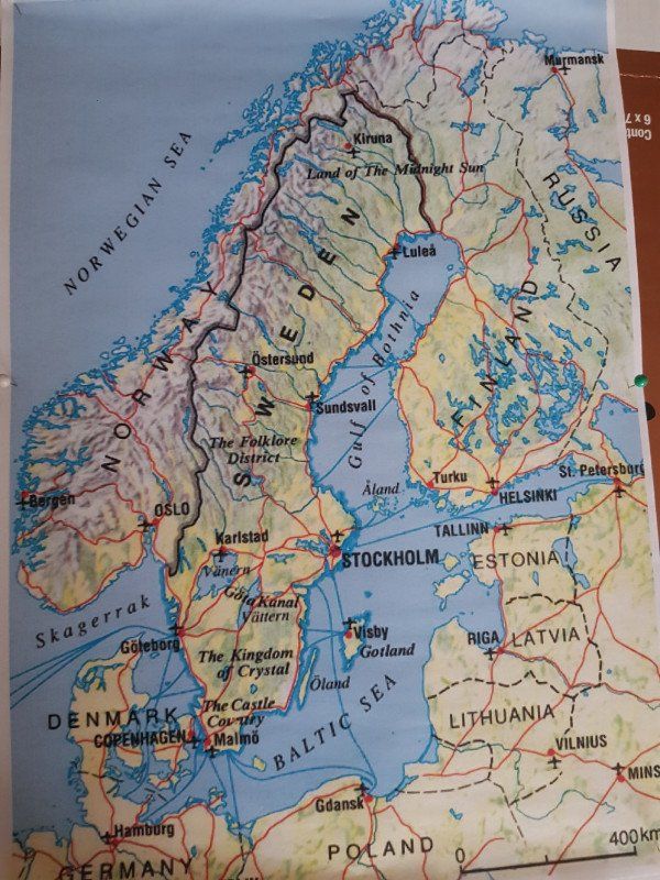
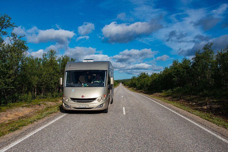
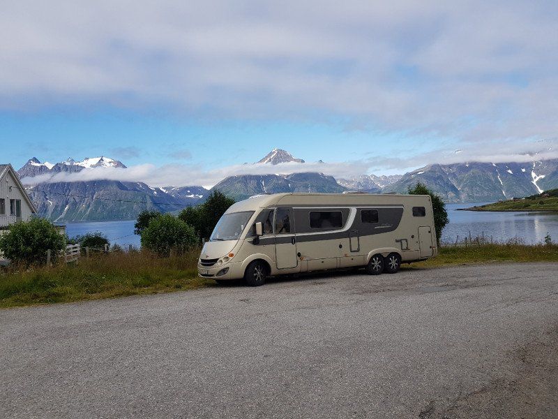
In three weeks with the Schilkrötli over the Arctic Circle to the Nordkapp, and the way back with idyllic pictures of the coast of Norway.
Day
Mönthal
Thursday, July 22nd, 2021
Let's start north at 7:30 p.m.
Schweiz
47° 31' 1.5" N 8° 8' 40.6" E
47.5170805 8.1446086
• Head toward Milchhüslistrasse on Hauptstrasse. Go for 409 m.
• Continue on Ampfernstrasse. Go for 2.1 km.
• Turn sharp left onto Dorfstrasse. Go for 3.8 km.
• Continue on Oberdorf. Go for 439 m.
• Turn right onto Hauptstrasse (3). Go for 2.2 km.
• Take the 2nd exit from roundabout onto Hauptstrasse (3). Go for 1.4 km.
• Take the 2nd exit from roundabout onto 24. Go for 414 m.
• Take left ramp onto A3 toward Basel/Eiken. Go for 23.2 km.
• Take exit 14A toward Deutschland/Rheinfelden-West. Go for 1.0 km.
• Continue on A861. Go for 88 m.
• Continue on A861. Go for 4.1 km.
• Take the left exit onto A98 (Dorfbachtalbrücke). Go for 16.3 km.
• Take exit 1 toward Karlsruhe/Stuttgart/Freiburg onto A5. Go for 287 km.
• Take the exit toward Hannover/Kassel/Frankfurt/Darmstadt onto A5. Go for 67.7 km.
• Take exit 12 toward Butzbach/Rockenberg. Go for 242 m.
• Turn left onto L3134 toward Lich/Butzbach/Laubach/Münzenberg/Griedel. Go for 490 m.
• Take the 2nd exit from roundabout onto Griedeler Straße (L3053) toward Gewerbegebiet Butzbach-Ost. Go for 1.1 km.
• Take the 2nd exit from roundabout onto Griedeler Straße toward Innenstadt. Go for 189 m.
• Turn right onto Küchengartenweg. Go for 272 m.
• Continue on Viehmarktplatz. Go for 88 m.
• Take the 2nd exit from roundabout onto Wetzlarer Straße. Go for 65 m.
• Continue on Kleeberger Straße. Go for 110 m.
• Arrive at Kleeberger Straße. Your destination is on the right.
☍
412,4 km
(3 hrs. 39 min.)
Day
Butzbach
After a short sleep break (5 hours) we continued our journey towards Rostock.
Km to be driven 540.
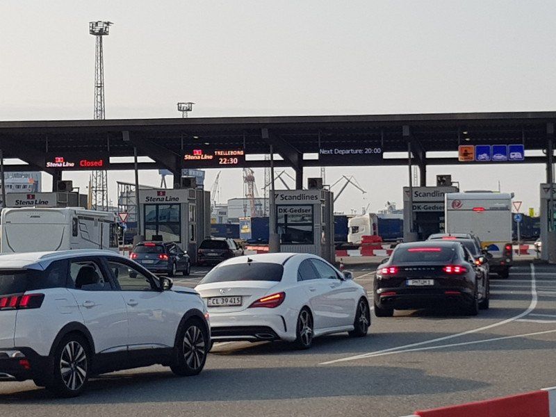
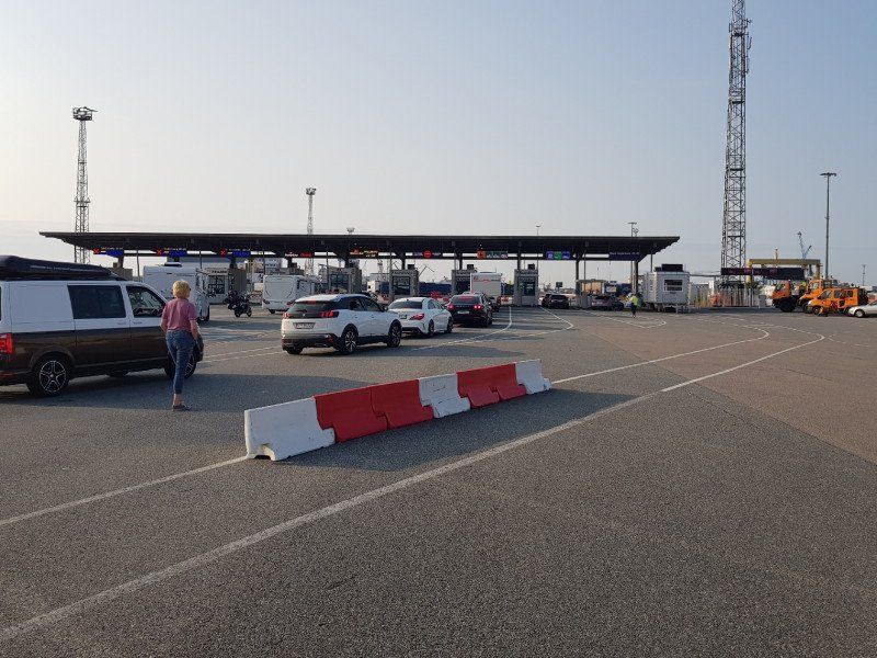
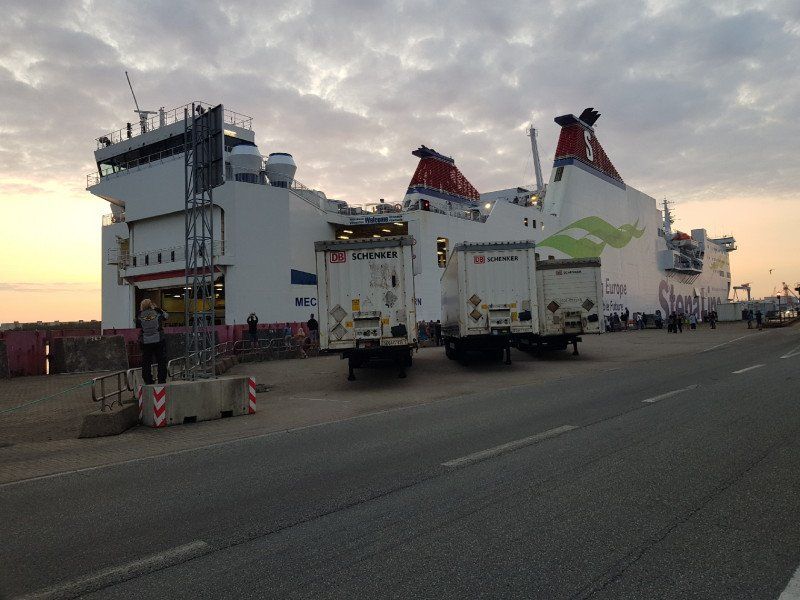
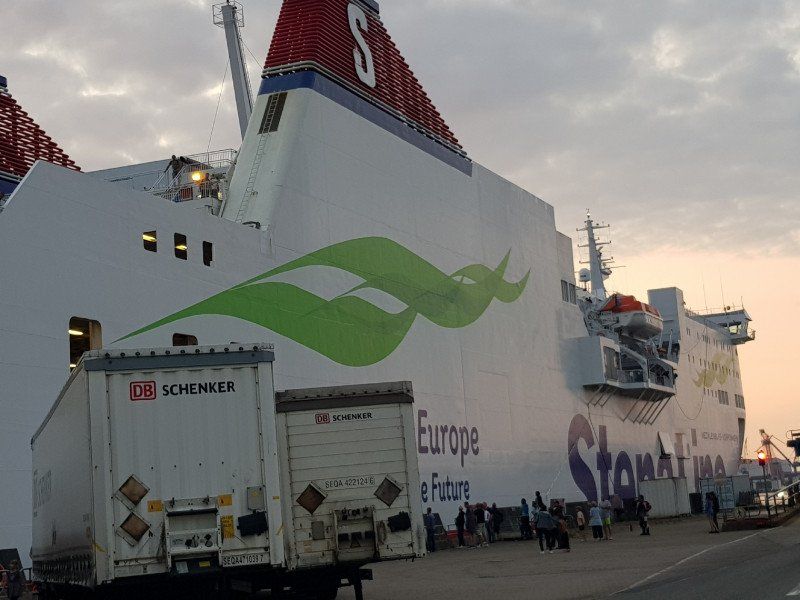
Arrival after a very pleasant journey at the ferry port at 17:00
Departure of the ferry to Trellenburg at 10.30 p.m.
Fully easy without stress.
Crossing to Trelleborg (southern Sweden) in hours 7.00
Costs for 2 people and a 9 meter Womo (there and back) With early booking discount 420 euros.
Deutschland
50° 26' 6.1" N 8° 40' 7.8" E
50.4350358 8.6688418
• Head toward Am Bollwerk on Kleeberger Straße. Go for 275 m.
• Take the 1st exit from roundabout onto Tepler Straße. Go for 383 m.
• Turn right onto Straße der Deutschen Einheit (B3). Go for 838 m.
• Take the 3rd exit from roundabout onto Griedeler Straße (L3053) toward A5/Lich. Go for 1.1 km.
• Take the 2nd exit from roundabout onto L3134 toward Kassel/A5/Frankfurt/Rockenberg/Griedel/Gewerbegebiet Griedel. Go for 520 m.
• Turn right and take ramp onto A5 toward Kassel/Dortmund/A45/Hanau. Go for 43.8 km.
• Take left exit 4 toward Kassel/Dortmund onto A49. Go for 79.2 km.
• Take exit 7 toward Hannover/Frankfurt onto A44. Go for 4.7 km.
• Take the left exit toward Hamburg/Hannover/Kassel onto A7. Go for 288 km.
• Keep left onto Horster Dreieck toward Lübeck/Berlin/Hamburg/Lüneburg/A1. Go for 2.5 km.
• Continue on A1. Go for 13.2 km.
• Take exit 36 toward Lübeck/Berlin/Hamburg-Südost onto A1. Go for 56.6 km.
• Take exit 24 toward Rostock/Lübeck-Genin/Flughafen Lübeck onto A20. Go for 122 km.
• Take exit 17 toward Rostock-Überseehafen/Rostock-Ost/B105 onto A19. Go for 15.9 km.
• Take exit 4 toward Ostsee-Fähren/Überseehafen/Ferries/Fähren onto E55 (Am Seehafen). Go for 752 m.
• Turn slightly left onto Zum Fährterminal (E55) toward Fähre Trelleborg/Fähre Gedser. Go for 616 m.
• Arrive at Zum Fährterminal (E55).
☍
629,9 km
(5 hrs. 31 min.)
Day
Zum Fährterminal
Check in 60 minutes in advance.
Ticket booked in February.
Return 2 adults with a motorhome up to 9m.
additionally with reclining seats.
approx. 430 euros.
is a very low price
Rostock, Deutschland
54° 8' 29.8" N 12° 6' 10.2" E
54.1416000 12.1028335
• Head northwest on Zum Fährterminal (E55).
• Take the 4th exit from roundabout onto Zum Fährterminal (E55). Go for 1.4 km.
• Turn right and take ramp onto A19 toward Berlin/Flugplatz Rostock-Laage/A20. Go for 31.5 km.
• Take exit 11 toward Flughafen Laage/Schwaan/Güstrow-Nord/Kritzkow. Go for 584 m.
• Turn right onto An der Chaussee (B103) toward Güstrow. Go for 10.8 km.
• Continue on Rostocker Straße (B104). Go for 857 m.
• Continue on Liebnitzstraße (L17) toward Goldberg. Go for 710 m.
• Turn left onto Plauer Straße. Go for 518 m.
• Turn right onto An der Fähre. Go for 46 m.
• Continue on An der Fähre. Go for 66 m.
• Arrive at An der Fähre. Your destination is on the left.
☍
46,5 km
( 33 min.)
An der Fähre
Güstrow, Rostock, Deutschland
53° 47' 1.2" N 12° 11' 12.1" E
53.7836674 12.1867029
• Head north on An der Fähre. Go for 112 m.
• Turn left onto Plauer Straße. Go for 518 m.
• Turn right onto Liebnitzstraße (L17). Go for 1.6 km.
• Continue on Rostocker Chaussee (B103). Go for 11.1 km.
• Turn right and take ramp onto A19 toward Rostock. Go for 32.1 km.
• Take exit 4 toward Ostsee-Fähren/Überseehafen/Ferries/Fähren onto E55 (Am Seehafen). Go for 752 m.
• Turn slightly left onto Zum Fährterminal (E55) toward Fähre Trelleborg/Fähre Gedser. Go for 616 m.
• Take the 3rd exit from roundabout onto Zum Fährterminal (E55) toward Fähre Gedser/Trelleborg. Go for 271 m.
• Keep left onto Zum Fährterminal (E55). Go for 369 m.
• Turn right onto Zum Fährterminal. Go for 49 m.
• Continue on Am Warnowkai. Go for 92 m.
• Turn right onto Am Warnowkai. Go for 722 m.
• Take the Rostock-Gedser Ferry. Stay on for 48.2 km.
• Head north on Gedser Landevej (E55). Go for 19.7 km.
• Keep right toward København. Go for 150 m.
• Continue on Nykøbing Falster Omfartsvej (E55). Go for 5.5 km.
• Turn right onto Skovalleen (E55) toward København. Go for 1.2 km.
• Take the 1st exit from roundabout onto Gaabensevej (E55). Go for 7.9 km.
• Take ramp onto E47/E55 (Sydmotorvejen) toward København. Go for 77.4 km.
• Continue on E20/E47 (Køge Vest). Go for 26.2 km.
• Continue on E20 (Avedøre) toward Malmø/Lufthavn/København C. Go for 27.7 km.
• Continue on E20 (Öresundsbron). Go for 12.6 km.
• Take the exit toward Trelleborg/Malmö C/Sjukhus onto E6/E22 (Trelleborgsvägen). Go for 20.2 km.
• Take the 2nd exit from roundabout onto E6/E22 toward Trelleborg. Go for 3.8 km.
• Continue on Slussgatan (9). Go for 1.0 km.
• Turn left onto Hansagatan toward Centrum/Sjukhus. Go for 131 m.
• Continue on Valldammsgatan. Go for 180 m.
• Turn right onto Nygatan. Go for 155 m.
• Turn left onto Olivia Nordgrens gata. Go for 81 m.
• Turn right onto Sankt Nicolai plan. Go for 46 m.
• Arrive at Sankt Nicolai plan. Your destination is on the left.
☍
300,5 km
(4 hrs. 29 min.)
Trelleborg
Schweden
55° 22' 34.5" N 13° 9' 26.7" E
55.3762427 13.1574231
• Head toward Flockergatan on Sankt Nicolai plan. Go for 46 m.
• Turn left onto Olivia Nordgrens gata. Go for 81 m.
• Turn right onto Nygatan. Go for 155 m.
• Turn left onto Valldammsgatan. Go for 180 m.
• Continue on Hansagatan. Go for 131 m.
• Turn right onto Hamngatan (9). Go for 1.0 km.
• Continue on E6/E22 toward Malmö. Go for 3.7 km.
• Take the 2nd exit from roundabout onto E6/E22 toward Malmö. Go for 19.3 km.
• Take exit 12 toward Göteborg/Kalmar onto E6/E20/E22 (Yttre Ringvägen). Go for 15.0 km.
• Continue on E6/E20 toward E4/Göteborg/Stockholm. Go for 5.1 km.
• Take exit 20 toward Lund/Kävlinge onto 103. Go for 2.8 km.
• Take the 3rd exit from roundabout onto 103/108 toward Kävlinge/Lund N. Go for 2.1 km.
• Take ramp onto Västra Ringen (103) toward Lund. Go for 569 m.
• Take the 2nd exit from roundabout onto Västra Ringen (103) toward E22/Centrum. Go for 522 m.
• Take the 3rd exit from roundabout onto Norra Ringen (E6.2) toward Kalmar/E22/Dalby/102. Go for 3.4 km.
• Take the 2nd exit from roundabout onto Norra Ringen (E6.2) toward Dalby/Kalmar/Malmö. Go for 619 m.
• Take the 3rd exit from roundabout onto E22 toward Kalmar. Go for 69.4 km.
• Take exit 37 toward Kalmar/Kristianstad onto E22 (Hässleholmsvägen). Go for 94.9 km.
• Pass 2 roundabouts and continue on E22. Go for 95.2 km.
• Take the exit toward Kalmar C/Centrum onto E22.9 (Erik Dahlbergs väg). Go for 767 m.
• Pass 2 roundabouts and continue on Erik Dahlbergs väg (E22.9). Go for 1.2 km.
• Turn right onto Norra vägen. Go for 224 m.
• Take the 2nd exit from roundabout onto Norra vägen. Go for 420 m.
• Turn left onto Unionsgatan. Go for 29 m.
• Turn right onto Jenny Nyströms gränd. Go for 158 m.
• Turn right. Go for 25 m.
• Arrive at your destination on the right.
☍
317,0 km
(3 hrs. 21 min.)
Day
Kalmar
Schweden
56° 39' 48.4" N 16° 21' 24.4" E
56.6634447 16.3567790
• Head toward Jenny Nyströms gränd. Go for 25 m.
• Turn left onto Jenny Nyströms gränd. Go for 158 m.
• Turn left onto Unionsgatan. Go for 29 m.
• Turn right onto Norra vägen. Go for 377 m.
• Take the 2nd exit from roundabout onto Norra vägen. Go for 276 m.
• Turn left onto Erik Dahlbergs väg (E22.9). Go for 966 m.
• Pass 2 roundabouts and continue on Erik Dahlbergs väg (E22.9). Go for 598 m.
• Take ramp onto E22 toward Norrköping/137/Öland. Go for 56.1 km.
• Continue on E22. Go for 178 km.
• Continue on Tingstad skola (E22). Go for 7.4 km.
• Take the 2nd exit from Ljurarondellen roundabout onto Söderköpingsvägen (E4.8) toward Centrum. Go for 2.2 km.
• Pass 2 roundabouts and continue on Ståthögavägen (E4.8). Go for 2.4 km.
• Take the 1st exit from Sandbyhovsrondellen roundabout onto Stockholmsvägen (E4.8) toward E4. Go for 220 m.
• Take the 2nd exit from Ingelstarondellen roundabout onto Stockholmsvägen (E4.8) toward E4/51/55/56. Go for 1.6 km.
• Continue on Stockholmsvägen. Go for 315 m.
• Continue toward Trafikplats Norrköping norra. Go for 297 m.
• Continue on Trafikplats Norrköping norra. Go for 406 m.
• Continue on E4 (Trafikplats Norrköping norra). Go for 155 km.
• Keep left onto E4 (Hagatunneln) toward Sundsvall/E18/Flygplats. Go for 6.5 km.
• Continue on E4 (Uppsalavägen). Go for 263 km.
• Take ramp toward Enånger. Go for 223 m.
• Turn left onto Bäckmoravägen toward Lindefallet/Enånger. Go for 677 m.
• Continue on Änga. Go for 427 m.
• Continue toward Militärvägen. Go for 173 m.
• Continue on Militärvägen. Go for 386 m.
• Arrive at Militärvägen. Your destination is on the right.
☍
677,7 km
(6 hrs. 50 min.)
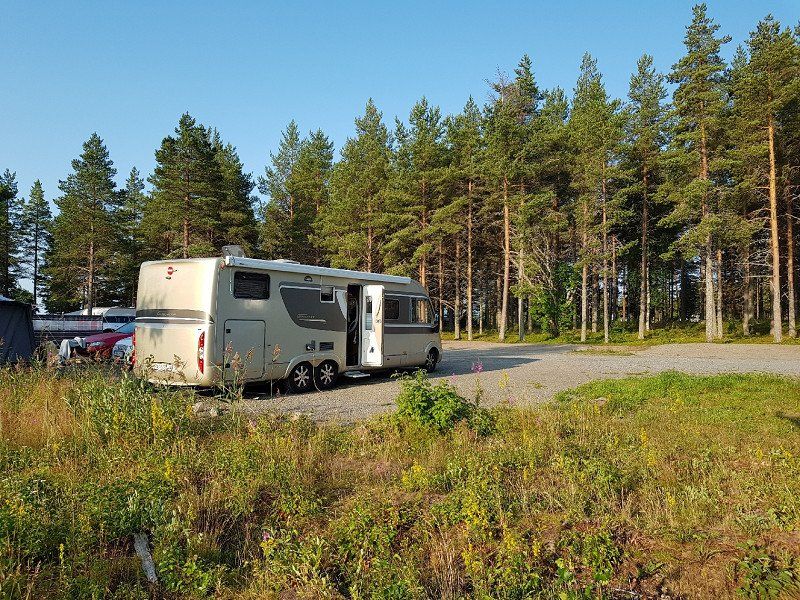
Enånger
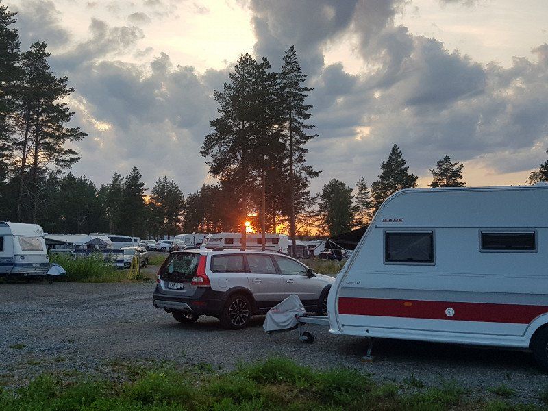
First part in Sweden from Trelleborg to Enganger. km 1054.
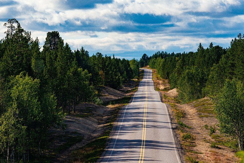
We chose the route along the coast along the E22 instead of the E4 via Kalmar to Stockholm to our destination for the day.
The route was very nice. But since it wasn't really a motorway, you just need a little more time.
Because the road often changes from two-lane to single-lane and back again.
Shortly before Stockholm you come to the E4, which is really a motorway as far as Stockholm.
The last 100 km will then become an expressway again with alternating overtaking lanes. But this one
Section is beautiful.
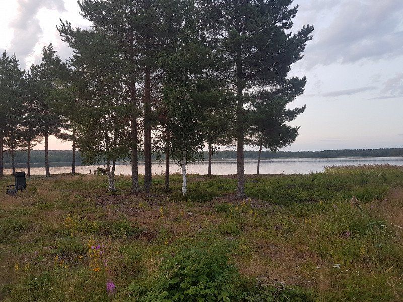
We finish our trip in Enganger as planned.
There you drive about 3 km to the water to the Borka restaurant.
There is a parking space by the water or a Borka campsite 500 meters beforehand.
Both places with toilet, shower and electricity.
Schweden
61° 32' 51.2" N 17° 0' 20.6" E
61.5475511 17.0057100
• Head toward Brunlövs väg on Militärvägen. Go for 446 m.
• Continue toward Änga. Go for 399 m.
• Continue on Änga. Go for 372 m.
• Continue on Bäckmoravägen. Go for 446 m.
• Turn right and take ramp onto E4 toward Sundsvall. Go for 142 km.
• Turn left onto Antjärn. Go for 406 m.
• Continue on Tjärnsjö. Go for 297 m.
• Continue on Tjärnsjö. Go for 4.4 km.
• Continue on Nyland. Go for 189 m.
• Continue on Nyland Erikslund. Go for 279 m.
• Turn right onto Billsta. Go for 3.3 km.
• Turn left toward Byåker. Go for 446 m.
• Continue on Byåker. Go for 823 m.
• Continue on Söderstig. Go for 1.0 km.
• Continue on Långslätten. Go for 865 m.
• Continue on Norrstig. Go for 369 m.
• Turn left onto E4. Go for 96.5 km.
• Take the 3rd exit from roundabout onto Centralesplanaden (E4) toward Haparanda. Go for 1.7 km.
• Turn right onto E4. Go for 949 m.
• Take the 3rd exit from roundabout onto E4 toward Haparanda. Go for 105 km.
• Take the 1st exit from Söderslättsrondellen roundabout onto Blå vägen (E4/E12) toward Haparanda/92/363/Sjukhus/364. Go for 1.6 km.
• Take the 3rd exit from Alviksrondellen roundabout onto Mineral (E4) toward Haparanda/E12/Mo i Rana/92/363/364. Go for 1.5 km.
• Take the 2nd exit from Gimonäsrondellen roundabout onto Mineral (E4) toward Haparanda/E12/Mo i Rana/92/363/364. Go for 658 m.
• Take the 2nd exit from Carlshemsrondellen roundabout onto Mineral (E4) toward Haparanda/E12/Mo i Rana/92/363/364. Go for 610 m.
• Pass 4 roundabouts and continue on E4. Go for 131 km.
• Take the 2nd exit from roundabout onto E4 toward Haparanda. Go for 1.6 km.
• Pass 2 roundabouts and continue on E4. Go for 176 km.
• Take ramp toward Kiruna/Töre/Töre hamn. Go for 359 m.
• Continue on E10. Go for 395 m.
• Arrive at Kirunavägen (E10). Your destination is on the left.
☍
673,9 km
(7 hrs. 14 min.)
Day
Töre
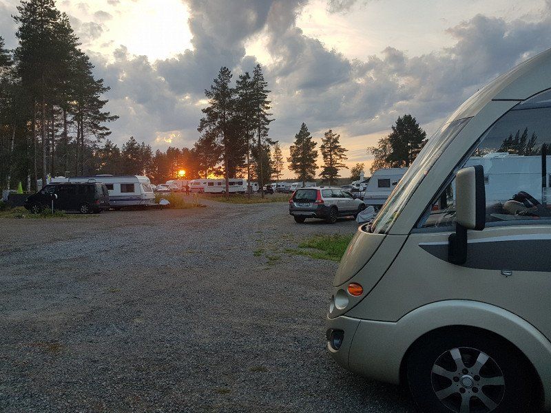
It is 670km from Enanger to Töre.
We turned right about 5 km before Töre and drove 11 km to the water.
To Camping Rörbäcken.
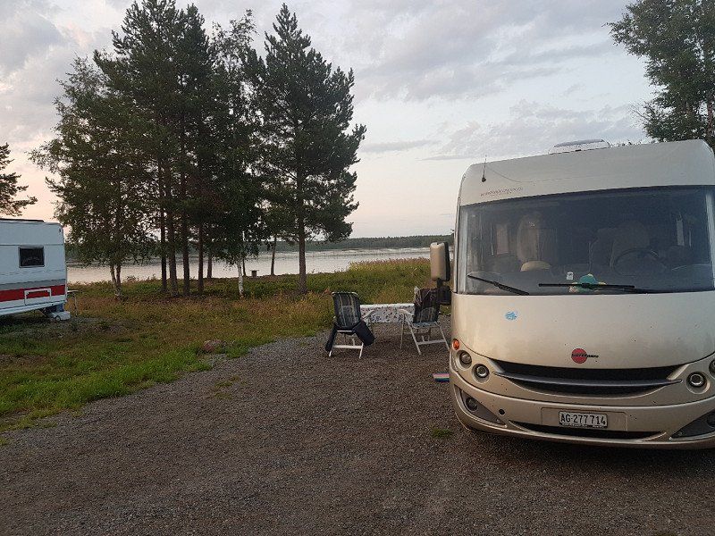
Located right on the water, very idyllic and cozy.
It has toilet and shower facilities that are very clean and appropriate.
For an additional 50 SK (5CHF.) You can go to the sauna for 1 hour. You have to enter and reserve the seat number in advance in the book in front of the sauna.
The water in the lake is about 12-14 degrees warm
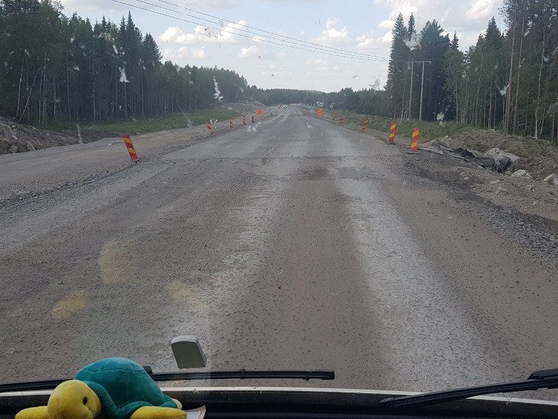
The journey on the E4 is very solid to drive with the exception of a few construction sites. Just keep to the speed, because there are always radar boxes ready.
Schweden
65° 54' 41.5" N 22° 39' 22.3" E
65.9115315 22.6561965
• Head north on Kirunavägen (E10). Go for 50.0 km.
• Turn right onto Hällan (98/392) toward Övertorneå/Pajala/Överkalix. Go for 1.5 km.
• Take the 2nd exit from roundabout onto 98/392 toward Pajala/Övertorneå. Go for 2.8 km.
• Turn right onto Övertorneåvägen (98) toward Övertorneå. Go for 43.7 km.
• Turn right onto 98/99 toward Haparanda/Övertorneå. Go for 2.0 km.
• Turn left onto Matarengivägen (98). Go for 1.9 km.
• Continue on Tullitie (98). Go for 623 m.
• Continue on Raanujärventie (930) toward Rovaniemi. Go for 2.9 km.
• Turn right onto Muurolantie (930). Go for 77.5 km.
• Turn left onto Kemintie (E75). Go for 21.1 km.
• Continue on Valtatie 4 (E75) toward Keskusta. Go for 3.8 km.
• Take ramp toward Kajaani/Ounasvaara/78. Go for 377 m.
• Turn right onto Poromiehentie (79) toward Kajaani/Ranua/Keskusta/Ounasvaara/78. Go for 119 m.
• Turn left toward Kajaani/Ranua/Ounasvaara. Go for 12 m.
• Arrive at Toripuistikko (78). Your destination is on the left.
☍
208,3 km
(2 hrs. 29 min.)
Day
Rovaniemi
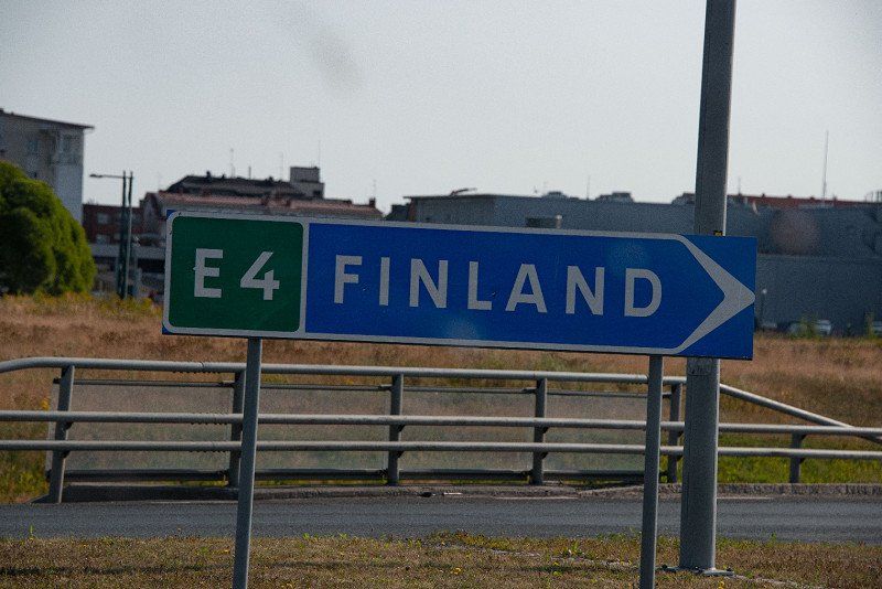
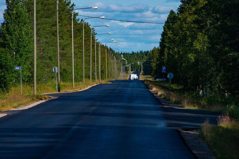
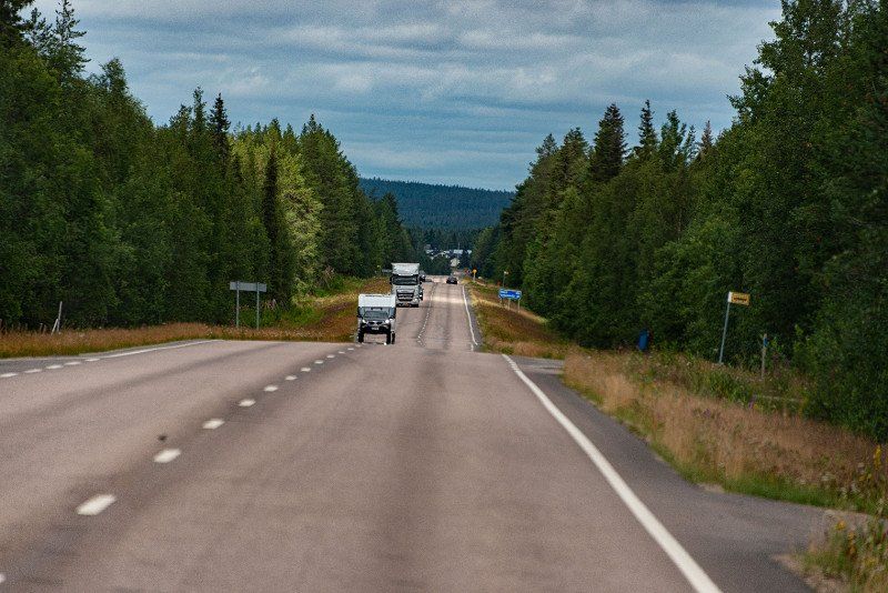
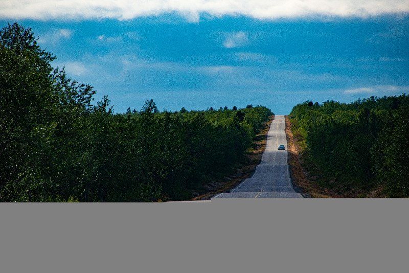
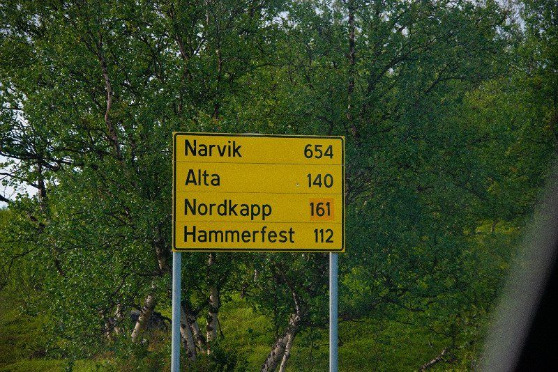
We decided to travel via Finland on the E75 motorway towards Nordkapp.
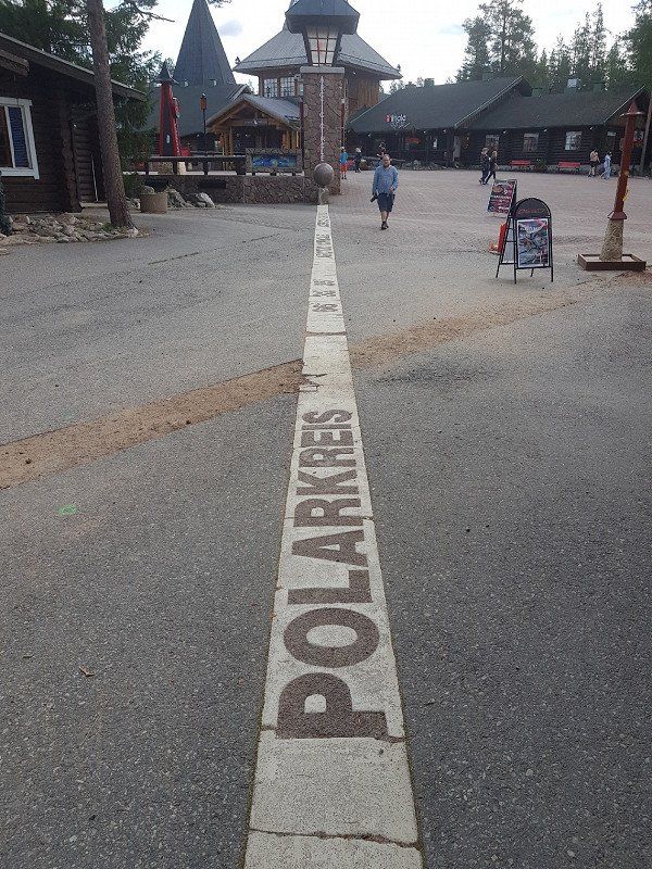
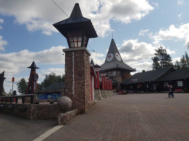
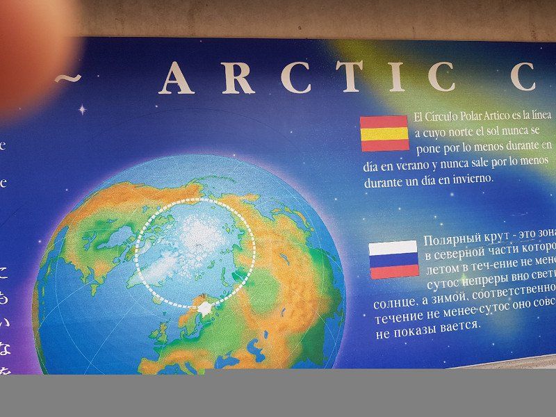
Shortly after Rovaniemi we cross the Arctic Circle. In the Arctic Circle, of course, St. Nicholas is widely marketed and the circle and its importance are rather in the background.
After the Arctic Circle towards Ivalo, the landscape becomes wilder and wilder and the bare nature comes to light more and more.
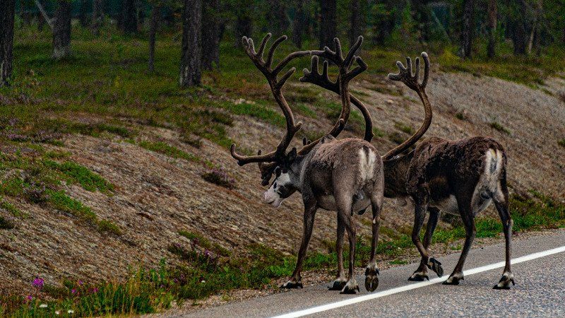
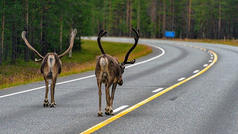
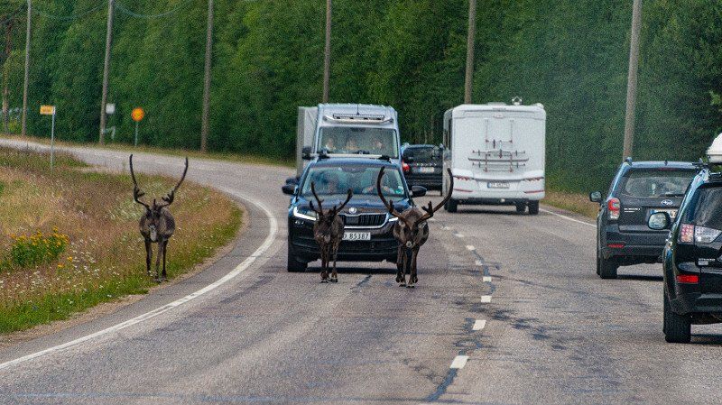
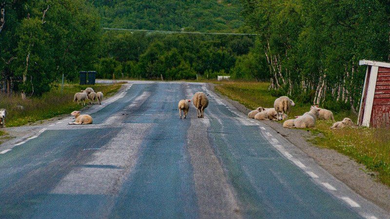
We see the first reindeer, of course in the middle of the street. For us motorists, this means the greatest caution, because the animals have right of way.
On the way we stop at a parking lot with a small coffee and a souvenir shop.
We stock up on freshly smoked salmon and trout.
At the same time we buy some reindeer meat. But then we continue north.
Finnland
66° 30' 14.2" N 25° 43' 45.8" E
66.5039478 25.7293905
• Head southeast on Toripuistikko (78). Go for 257 m.
• Make a U-Turn onto Toripuistikko (78). Go for 324 m.
• Turn right onto Poromiehentie (79) toward Ivalo/4/Kemi/Muonio/83/E75/Lentoasema. Go for 231 m.
• Take ramp onto Valtatie 4 (E75) toward Ivalo/Kemijärvi/82/Lentoasema. Go for 128 km.
• Take the 2nd exit from roundabout onto Sodankyläntie (E75) toward Ivalo. Go for 899 m.
• Pass 2 roundabouts and continue on Ivalontie (E75). Go for 159 km.
• Enter the roundabout. Go for 39 m.
• Arrive at your destination on the left.
☍
288,4 km
(3 hrs. 15 min.)
Ivalo
In Inari we fill up again. The price per liter of diesel is 1.49 euros (if you look around).
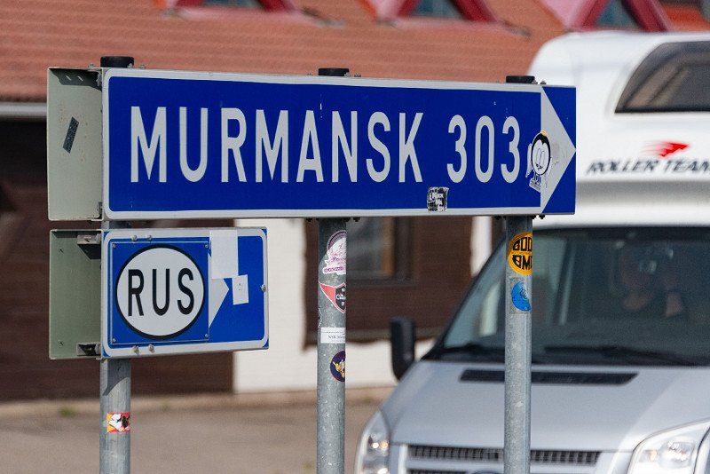
We cross an intersection where a sign to the right says: Murmansk 303km. Yes, we are very close to the Russian border.
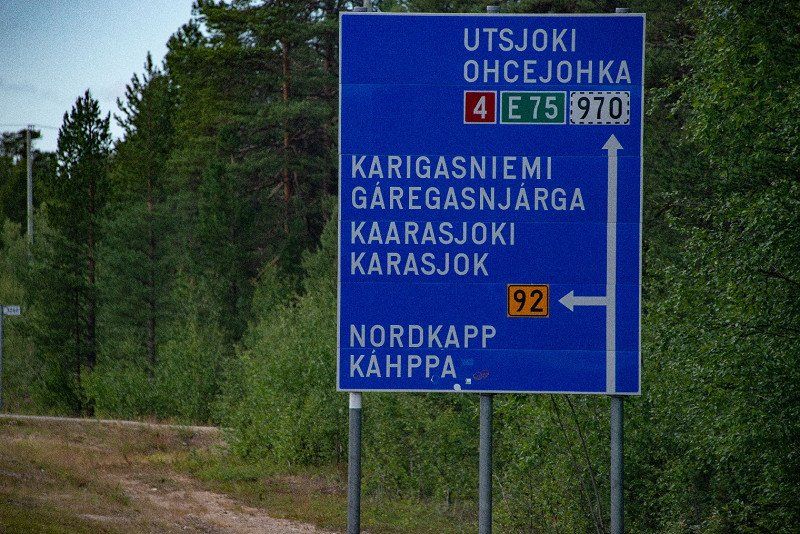
To the left we continue on the yellow Route 92. Straight ahead we would go to Kirkenes, where the King Krampen are fished.
Route 92 is absolute the hammer. Straight ahead, whatever it means with straight ahead. And then up and down. Up to the Norwegian border.
Inari, Finnland
68° 39' 27.5" N 27° 32' 22.9" E
68.6576419 27.5397058
• Follow the roundabout. Go for 62 m.
• Take the 4th exit from roundabout onto Ivalontie (E75) toward Utsjoki/Ohcejohka. Go for 233 m.
• Take the 2nd exit from roundabout onto Ivalontie (E75) toward Utsjoki/Ohcejohka. Go for 71.4 km.
• Turn left onto Karigasniementie (92) toward Karigasniemi/Gáregasnjárga/Kaarasjoki/Karasjoki/Nordkapp/Karppa. Go for 66.5 km.
• Continue on Suomageaidnu (92). Go for 18.0 km.
• Take the 3rd exit from roundabout onto Kautokeinoveien (E6) toward Alta/Leavdnja/Lakselv/92/Guovdageaidnu/Kautokeino. Go for 350 m.
• Take the 1st exit from roundabout onto Leavnnjageaidnu (E6) toward Alta/Leavdnja/Lakselv. Go for 73.4 km.
• Take the 3rd exit from roundabout onto E6 toward Alta. Go for 63.7 km.
• Continue on E69 toward Nordkapp/Honningsvåg. Go for 2.6 km.
• Continue on Øverland (E69). Go for 113 m.
• Continue on E69. Go for 4.6 km.
• Continue on Solberg (E69). Go for 84 m.
• Continue on E69. Go for 8.6 km.
• Continue on Sørset (E69). Go for 138 m.
• Continue on E69. Go for 3.4 km.
• Continue on Skarvbergtunnelen (E69). Go for 4.7 km.
• Continue on E69. Go for 4.2 km.
• Continue on Sortviktunnelen (E69). Go for 490 m.
• Continue on E69. Go for 15.4 km.
• Continue on Stranda (E69). Go for 1.6 km.
• Continue on E69. Go for 12 m.
• Continue on Stranda (E69). Go for 1.8 km.
• Continue on E69. Go for 425 m.
• Continue on Reinelva (E69). Go for 2.7 km.
• Continue on E69. Go for 1.9 km.
• Continue on Indre Mannskarvika (E69). Go for 389 m.
• Continue on E69. Go for 8.8 km.
• Continue on Porsangervika (E69). Go for 1.3 km.
• Continue on E69. Go for 706 m.
• Continue on Porsangervika (E69). Go for 381 m.
• Continue on E69. Go for 3.2 km.
• Continue on Kåfjord (E69). Go for 6.1 km.
• Continue on E69. Go for 154 m.
• Continue on Vesterpollen (E69). Go for 44 m.
• Continue on Laholmen (E69). Go for 66 m.
• Continue on Nordkapptunnelen (E69). Go for 6.8 km.
• Continue on E69. Go for 733 m.
• Continue on Veidnesbrua (E69). Go for 675 m.
• Continue on E69. Go for 9 m.
• Continue on Sarnesveien (E69). Go for 1.5 km.
• Continue on E69. Go for 480 m.
• Continue on Sarnestunnelen (E69). Go for 225 m.
• Continue on E69. Go for 48 m.
• Continue on Sarnesveien (E69). Go for 2.6 km.
• Continue on E69. Go for 118 m.
• Continue on Ørntind (E69). Go for 371 m.
• Continue on Sarnesveien (E69). Go for 555 m.
• Continue on E69. Go for 422 m.
• Continue on Sarnesveien (E69). Go for 1.4 km.
• Continue on E69. Go for 111 m.
• Continue on Honningsvågtunnelen (E69). Go for 4.5 km.
• Continue on E69. Go for 108 m.
• Continue on Kobbhullveien (E69). Go for 1.3 km.
• Continue on E69. Go for 511 m.
• Turn left onto Nordkappveien (E69). Go for 637 m.
• Continue on E69. Go for 154 m.
• Continue on Skipsfjorden (E69). Go for 5.2 km.
• Continue on E69. Go for 13.0 km.
• Turn left onto E69. Go for 12.4 km.
• Arrive at E69. Your destination is on the right.
☍
421,3 km
(5 hrs. 52 min.)
Nordkapp
From Töre we try to get the 907 km to the Nordkapp in one day.
Because we know that the weather on Tuesday (the following day) should be super nice.
On the way we discussed the midnight sun on the Nordkapp. Then it became clear to us that if it should only be nice on Tuesday, it would be better to arrive at the Nordkapp on Monday evening.
So after the solid journey on Route 92 we cross the Norwegian border. During this corona time, strict controls are made to ensure that you have the valid vaccination certificate with you.
We drive towards Laksely, approx. 80 km
There are also very nice straight stretches here. And sometimes you really feel totally in the wilderness.
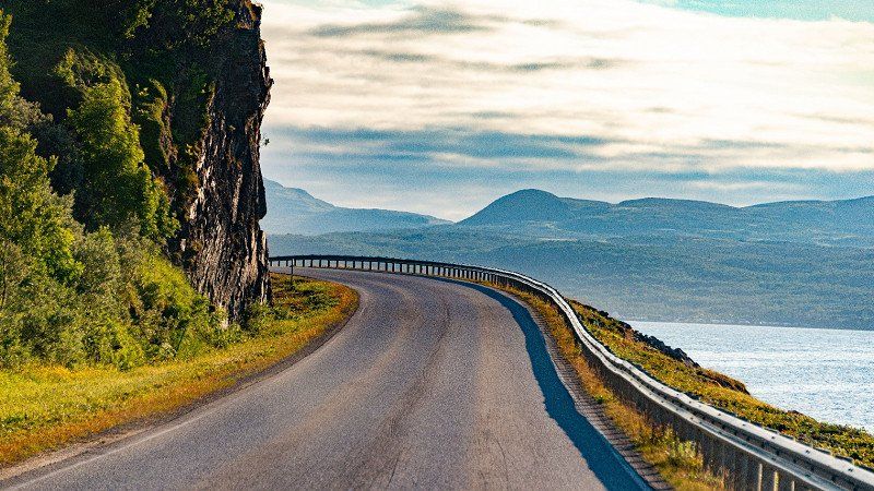
The route further to Olderfjord along the coast is very strenuous. Curvy, animals on the street, bumps and sometimes a little narrow.
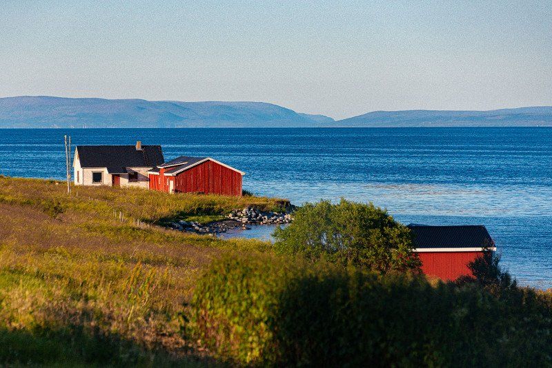
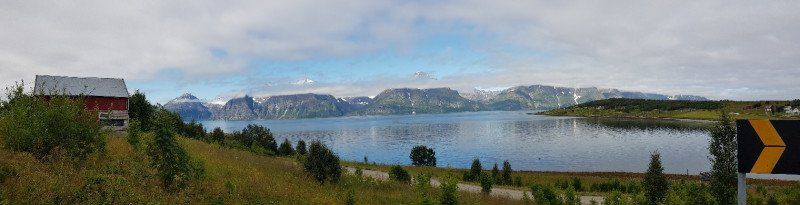
With the evening sun and clear blue sky, everything looks very picturesque and beautiful. The fjord, the mountains, rocks and hills, then no matter how individual groups of houses with red, yellow and brown houses that are reflected in the smooth water.
After an exhausting 70 km we arrive at the junction to Alta or just right towards Norkapp.
Our navigation system still shows us an arrival time of 10:30 p.m. That looks good.
We are still missing a full 130km on a coastal road with construction sites, tunnels and pass roads. The road gradually gets smaller the closer we get to the Kapp. The sky towards the north is still very open and clear. Hope rises and we step on the gas again.
Before we hit Honningsvag, there is even a small airport, we drive under the fjord through a tunnel. With a 10% descent into the tunnel and then again with a 10% incline out of the tunnel. It was a special feeling.
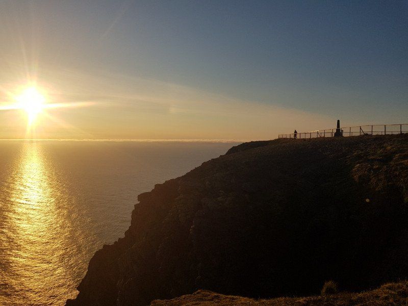
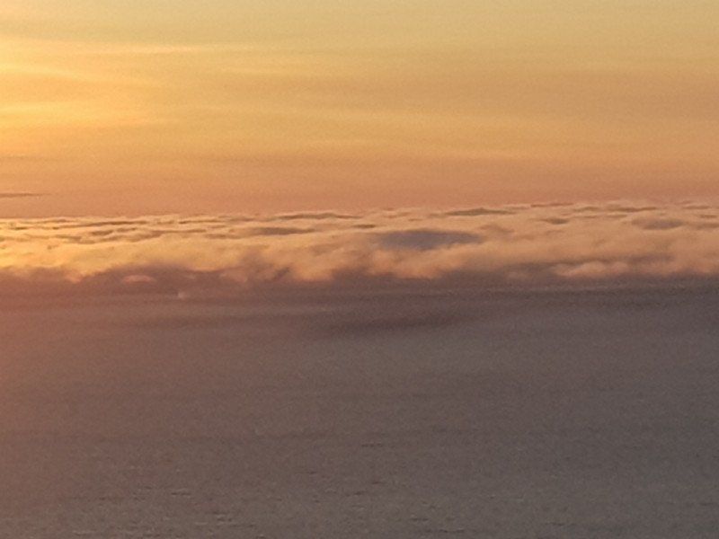
Leaving the last place behind us, we get closer and closer to the Nordkapp. It is exhausting and beautiful and at the end there is a huge climb.
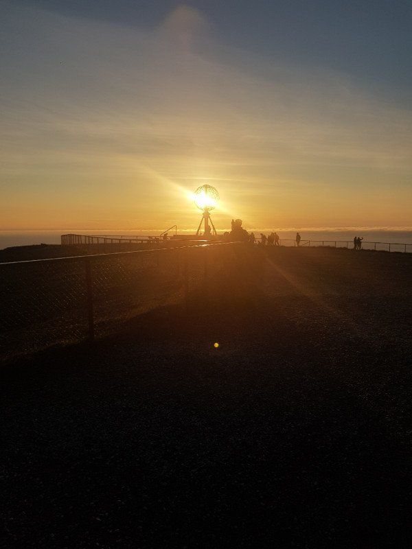
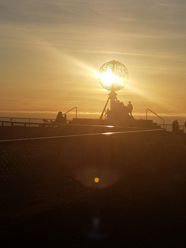
Then shortly before the goal a fog bank. We thought that was it.
But lo and behold in the parking lot clear sky and the sun on the high horizon.
It was worth getting up early in Töre (departure approx. 07:00) / arrival Nordkapp 22:30.
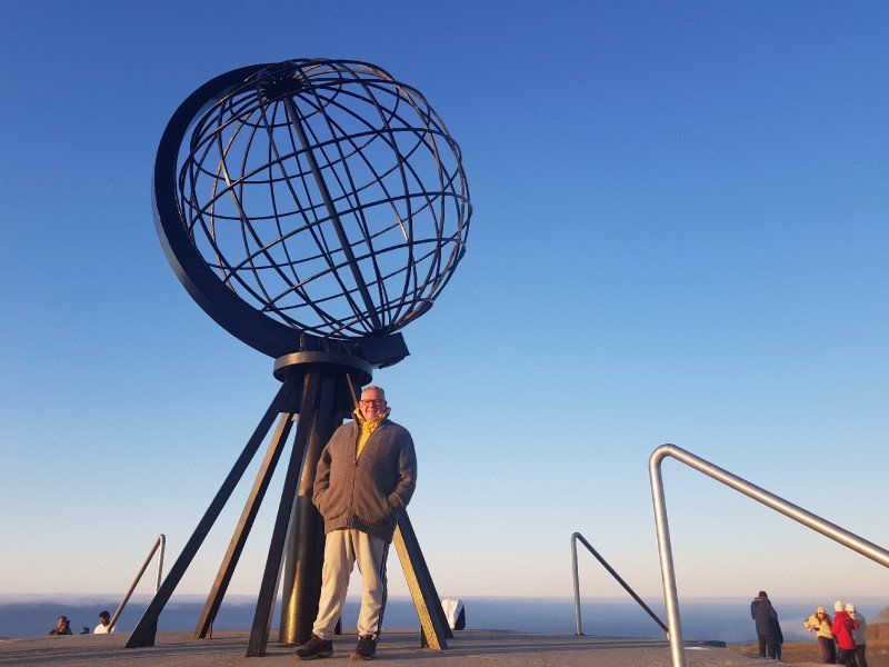
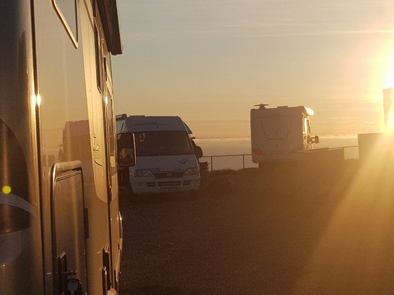
Then we started taking photos and enjoying the whole thing. That night the sun never left us.
We were able to enjoy the beautiful weather until Tuesday afternoon at 5:00 p.m. Then came the familiar fog.
Norwegen
71° 10' 10.2" N 25° 46' 59.4" E
71.1694930 25.7831640
• Head north on E69.
• Arrive at E69. Your destination is on the right.
☍
Distance not available
(Duration not available)
Day
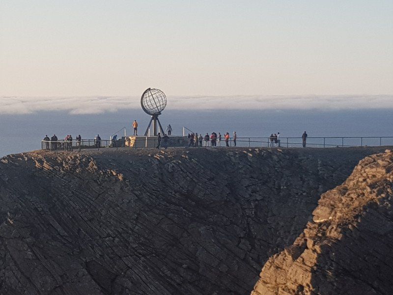
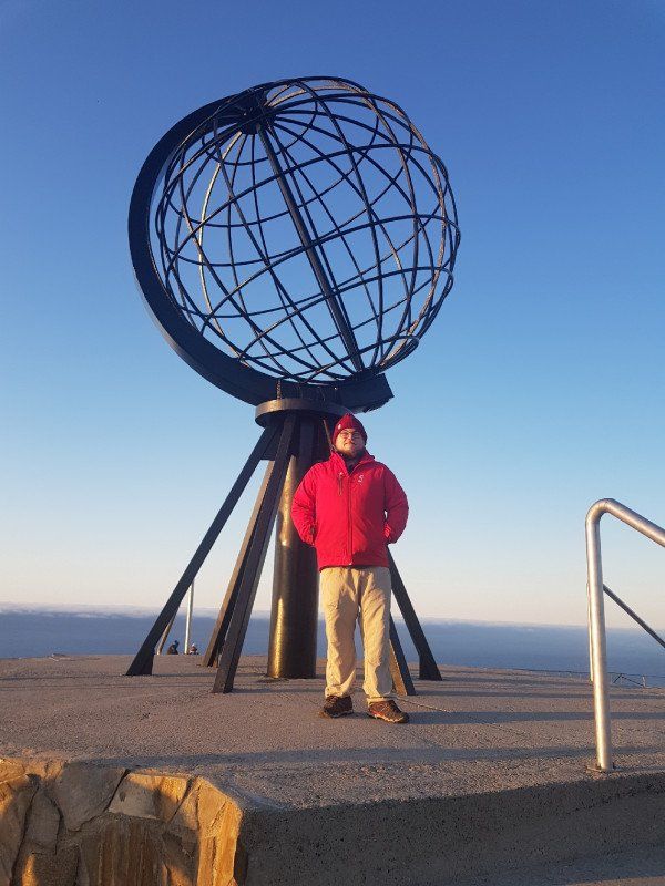
Nordkapp
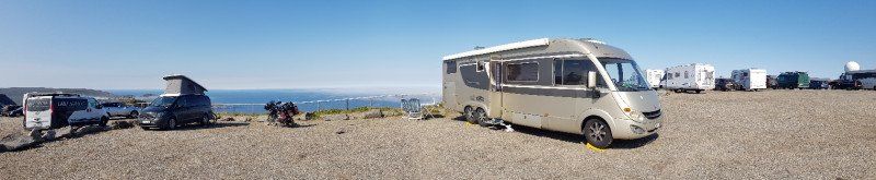
Since the wonderful night with the midnight sun was very early, we retired until 11 a.m.
But the nice weather lures us to the door (in front of the camper).
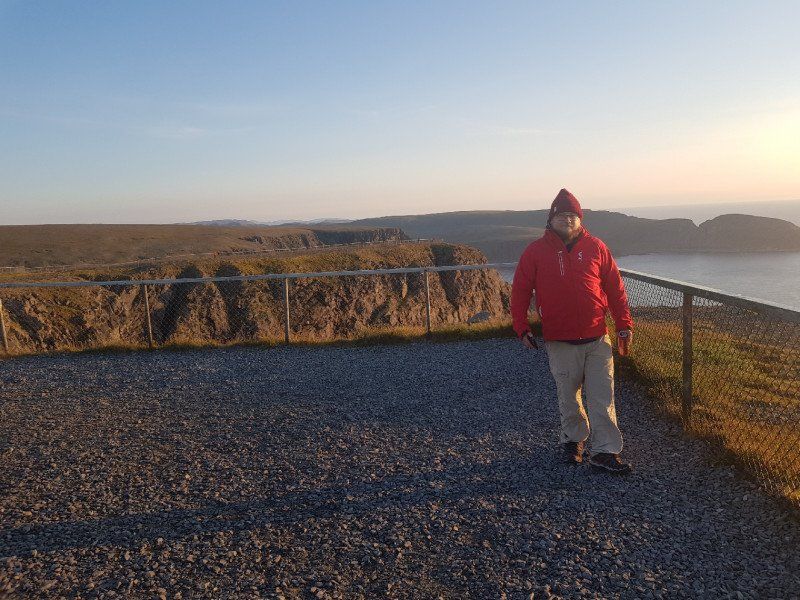
We set up the table and have breakfast in the midday sun on the Nordkapp.
It's amazingly warm to relax and enjoy.
In the afternoon we take a few more impressive pictures. Especially when the fog slowly but surely takes hold of the Kapp.
At 5:30 p.m. the time has come, everything shrouded in fog.
So we see this as the right time to follow the story of the Norkapp.
We pay the equivalent of 25 euros, and so come to the main building, and thus also to all services.
Such as sp. A 15min. Film with all the 4 seasons on the Kapp, the war story of World War II, as well as the clear explanation why the sun does not set in the summer months .......
And much more. I think that when you have made the trip to the Kapp, you should take this time to learn more about the Nordkapp.
We spend a second night in the fog on the Kapp. There was no longer any chance of a second midnight sun.
Norwegen
71° 10' 10.2" N 25° 46' 59.4" E
71.1694930 25.7831640
• Head south on E69. Go for 9.4 km.
• Continue on E69. Go for 2.9 km.
• Turn right onto E69. Go for 13.0 km.
• Continue on Skipsfjorden (E69). Go for 5.2 km.
• Continue on E69. Go for 154 m.
• Continue on Nordkappveien (E69). Go for 637 m.
• Turn right onto E69. Go for 511 m.
• Continue on Kobbhullveien (E69). Go for 1.3 km.
• Continue on E69. Go for 108 m.
• Continue on Honningsvågtunnelen (E69). Go for 4.5 km.
• Continue on E69. Go for 111 m.
• Continue on Sarnesveien (E69). Go for 1.4 km.
• Continue on E69. Go for 422 m.
• Continue on Sarnesveien (E69). Go for 555 m.
• Continue on Ørntind (E69). Go for 371 m.
• Continue on E69. Go for 118 m.
• Continue on Sarnesveien (E69). Go for 2.6 km.
• Continue on E69. Go for 48 m.
• Continue on Sarnestunnelen (E69). Go for 225 m.
• Continue on E69. Go for 480 m.
• Continue on Sarnesveien (E69). Go for 1.5 km.
• Continue on E69. Go for 9 m.
• Continue on Veidnesbrua (E69). Go for 675 m.
• Continue on E69. Go for 733 m.
• Continue on Nordkapptunnelen (E69). Go for 6.8 km.
• Continue on Laholmen (E69). Go for 66 m.
• Continue on Vesterpollen (E69). Go for 44 m.
• Continue on E69. Go for 154 m.
• Continue on Kåfjord (E69). Go for 6.1 km.
• Continue on E69. Go for 3.2 km.
• Continue on Porsangervika (E69). Go for 381 m.
• Continue on E69. Go for 706 m.
• Continue on Porsangervika (E69). Go for 1.3 km.
• Continue on E69. Go for 8.8 km.
• Continue on Indre Mannskarvika (E69). Go for 389 m.
• Continue on E69. Go for 1.9 km.
• Continue on Reinelva (E69). Go for 2.7 km.
• Continue on E69. Go for 425 m.
• Continue on Stranda (E69). Go for 1.8 km.
• Continue on E69. Go for 12 m.
• Continue on Stranda (E69). Go for 1.6 km.
• Continue on E69. Go for 15.4 km.
• Continue on Sortviktunnelen (E69). Go for 490 m.
• Continue on E69. Go for 4.2 km.
• Continue on Skarvbergtunnelen (E69). Go for 4.7 km.
• Continue on E69. Go for 3.4 km.
• Continue on Sørset (E69). Go for 138 m.
• Continue on E69. Go for 8.6 km.
• Continue on Solberg (E69). Go for 84 m.
• Continue on E69. Go for 4.6 km.
• Continue on Øverland (E69). Go for 113 m.
• Continue on E69. Go for 2.6 km.
• Turn right onto E6. Go for 23.1 km.
• Turn left onto Repparfjorddalen (E6) toward Alta. Go for 80.7 km.
• Pass 6 roundabouts and continue on Altaveien (E6). Go for 4.8 km.
• Enter the roundabout. Go for 31 m.
• Arrive at your destination.
☍
236,2 km
(3 hrs. 30 min.)
Day
Alta
We leave the Norkapp at 7:00 am, in light fog / cloudy conditions.
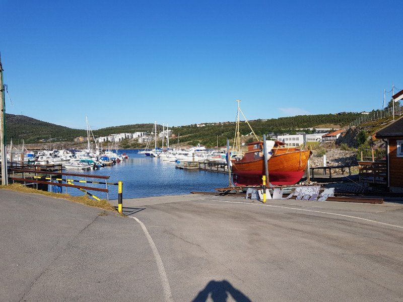
At the first village, Hanningsvag, we make a short stop to buy fresh bread and a few little things.
Then a little walk with a few photos at the harbor.
Outside the port, we put the camper in a parking lot right by the fjord, and enjoy breakfast with smoked salmon, ginger tea and fresh bread.
Then we tackle the route to Alta. We drive on the E69 to Olderfjord.
On this already quite demanding route, I almost shut my eyes, although it is only morning. Yes with always being day, it has to be. You go to bed late and don't get enough sleep.
So we make a stop at the campsite at the Olderfjord junction. We pay 70 NoK and are allowed to connect the camper to the electricity and use the shower.
Then I take a nap, of a good 2 hours.
Showers, empty the chemical toilet, fill up with fresh water and continue on the E6 to Alta.
On the following 60-80 km we experience a high-light of landscape, expanse and pass. Simply pure nature.
The town in front of Alta seems more interesting to us than Alta itself.
We stop at the harbor and enjoy the view over the fjord.
Since the weather is coming up and the evening sun is shining from the sky, we decide to drive on to a place facing north, in order to possibly watch the short sunset. (Setting at 23:50 / rising at 0:30.
Norwegen
69° 58' 7.5" N 23° 16' 17.6" E
69.9687376 23.2715496
• Follow the roundabout. Go for 63 m.
• Take the 4th exit from roundabout onto Altaveien (E6). Go for 581 m.
• Take the 2nd exit from roundabout onto Altaveien (E6) toward 93/Narvik. Go for 118 km.
• Turn sharp right. Go for 319 m.
• Arrive at your destination.
☍
119,2 km
(1 hrs. 32 min.)
Kvaenangen
We drive from Alta up to the pass of Kvaenangen E6.
There we put our camper on a small parking lot on a hill (approx. 350m above sea level) with a view to the north.
But unfortunately the fog and the clouds have us fully under control.
So no sunset.
After a simple zNacht we go to bed at about 23:50.
Driven km 369.
Day wake up agreed at 8:00 a.m.
Norwegen
69° 53' 2.6" N 21° 40' 15.4" E
69.8840640 21.6709400
• Head toward Kvænangsveien. Go for 319 m.
• Turn right onto Kvænangsveien (E6). Go for 105 km.
• Turn left onto Kåfjorddalsveien (7936) toward Birtavarre/Kåfjorddalen/Helsesenter Sykehus. Go for 183 m.
• Turn right onto Kåfjorddalsvegen. Go for 202 m.
• Turn right onto Kåfjorddalsveien (7936). Go for 648 m.
• Turn slightly left onto Kåfjorddalsvegen (7936). Go for 24 m.
• Turn slightly right onto Kåfjorddalsveien (333). Go for 157 m.
• Continue on Kåfjorddalsveien (7936). Go for 4.9 km.
• Turn left onto Kåfjorddalsveien. Go for 50 m.
• Arrive at Kåfjorddalsveien. Your destination is on the right.
☍
111,2 km
(1 hrs. 36 min.)
Day
Kåfjorddalen
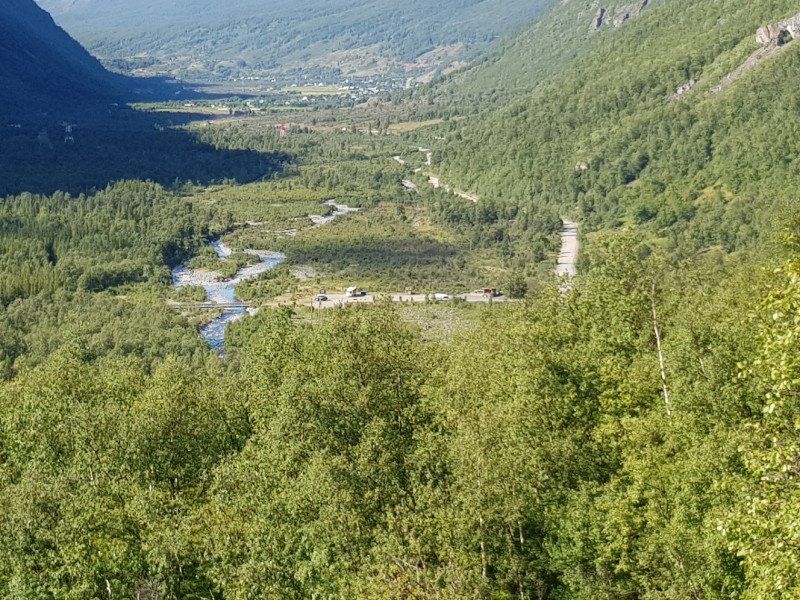
When I woke up in the parking lot with a view to the north, the fog had cleared, but it was cloudy.
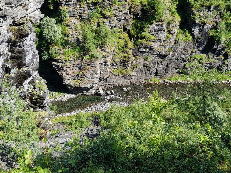
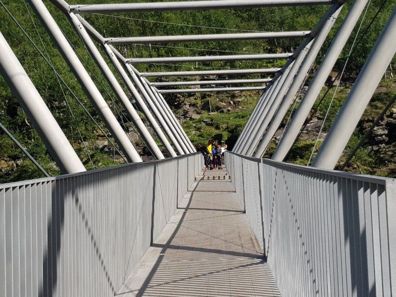
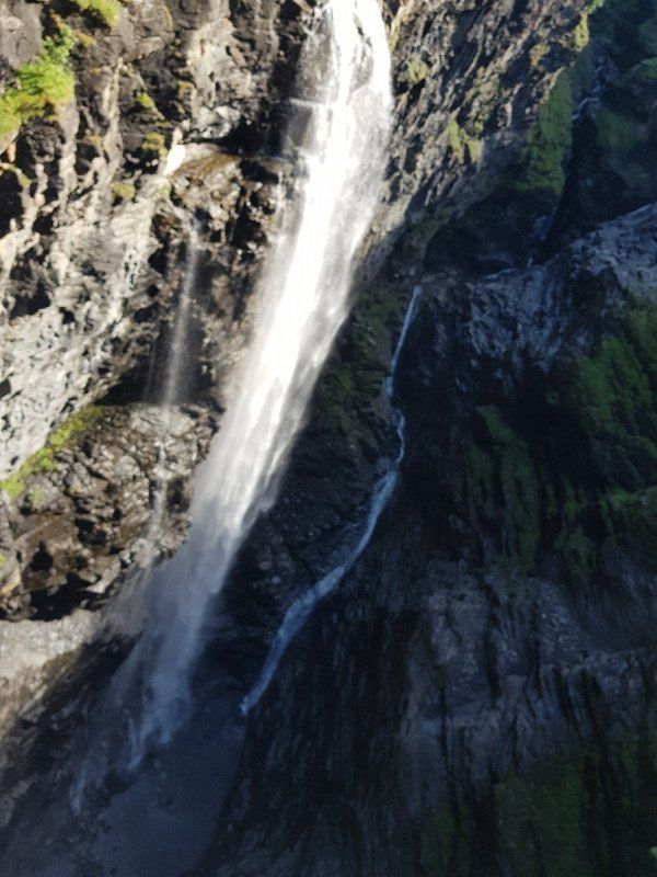
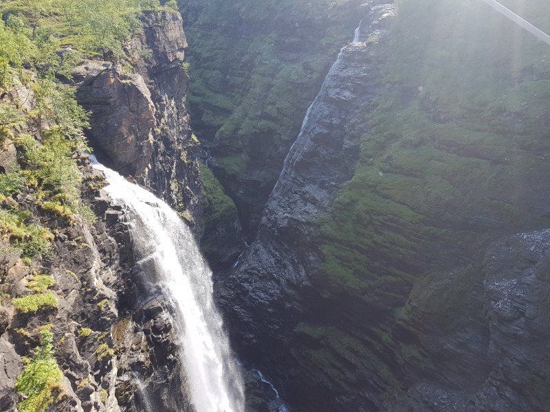
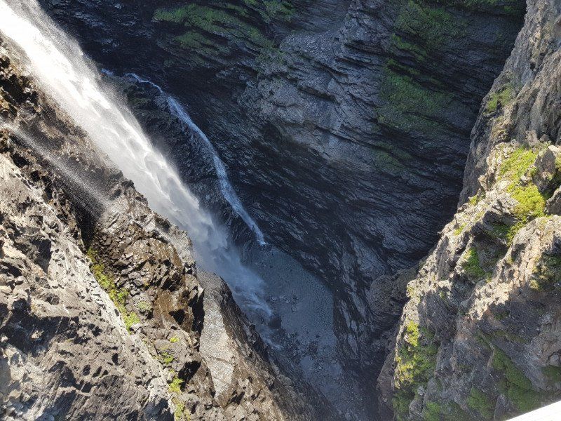
We start at 9:00 in the direction of Kafjorddalen. There we will lace up our hiking boots and hike a little to the Gorsabrua waterfall
For now we drive a few km to the junction to the left into the valley at Kafjorddalen.
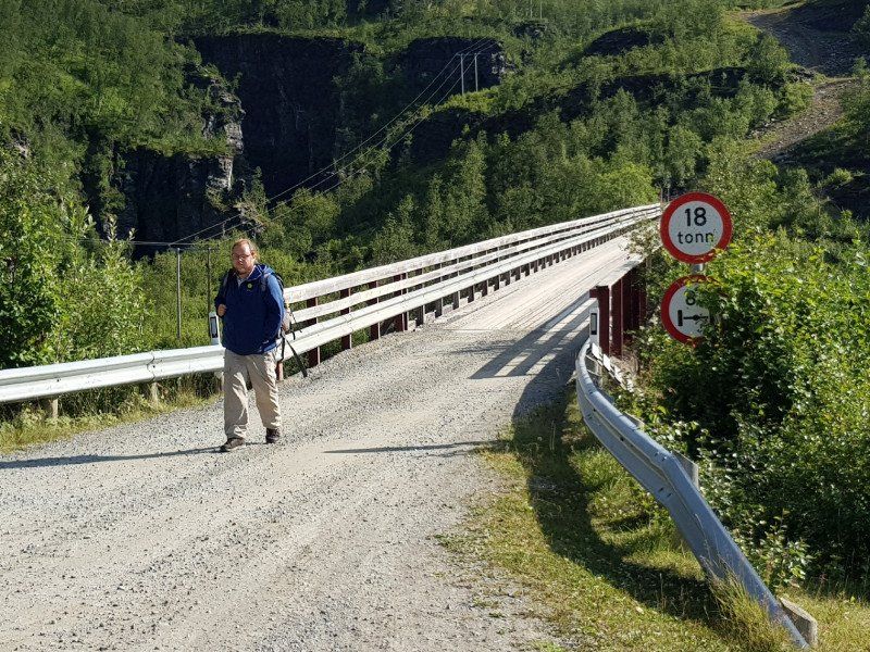
The small road leads us to a private road (gravel road) after approx. 7 km. Just keep going.
We take the first parking lot because we want to protect our motorhome and not go up the mountain with this gravel road.
If you take the hiking trail to the right across the river, you cross for a while the open-air museum of a copper mine that was still in operation 90 years ago.
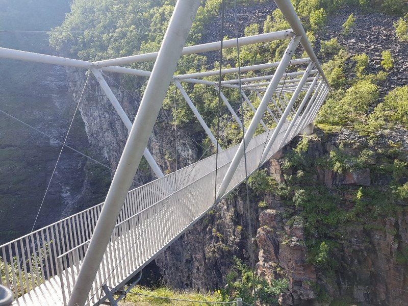
The path continues through wild nature for about 3.6km, until you finally see and can enter the bridge by the waterfall.
It was worth it. By the way, we had bright sunshine.
You have to experience that.
Back we take the easy way over the upper parking lot and along the street until we get back to our mobile home after about 4 hours.
After a good cool ... we decide to make the way to Tromsö.
That was 163km to drive.
So we arrive in Tromsö around 7:00 p.m. Camping Tromsö is fully booked, what now?
Norwegen
69° 27' 40.6" N 20° 56' 10.1" E
69.4612822 20.9361422
• Head west on Kåfjorddalsveien. Go for 50 m.
• Turn right onto Kåfjorddalsveien (7936). Go for 4.9 km.
• Continue on Kåfjorddalsveien (333). Go for 157 m.
• Turn slightly left onto Kåfjorddalsvegen (7936). Go for 24 m.
• Turn slightly right onto Kåfjorddalsveien (7936). Go for 648 m.
• Turn left onto Kåfjorddalsvegen. Go for 202 m.
• Turn left onto Kåfjorddalsveien (7936). Go for 183 m.
• Turn left onto E6. Go for 86.0 km.
• Turn right onto E8 toward Tromsø. Go for 68.5 km.
• Take the 3rd exit from roundabout onto Bruvegen (862). Go for 1.8 km.
• Turn left onto Skippergata. Go for 282 m.
• Turn right onto Bispegata. Go for 123 m.
• Turn left onto Grønnegata. Go for 357 m.
• Turn left onto Fredrik Langes gate. Go for 48 m.
• Arrive at Fredrik Langes gate. Your destination is on the right.
☍
163,3 km
(2 hrs. 15 min.)
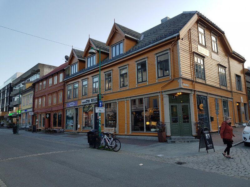
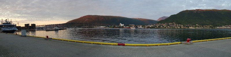
Tromsø
After crossing the bridge, we drive around the city in the tunnel and come to the end of the city again to the daylight, where there is also a car park. Close to the port.
We park the mobile home and buy a ticket for 24 hours. Costs 295 NK ... approx. 30 sCHF.
Without electricity and nothing ... what can you say?
As it is almost 8 p.m. we are already on our way to the center of Tromso to eat something Nordic. (Fish, shrimp or?)
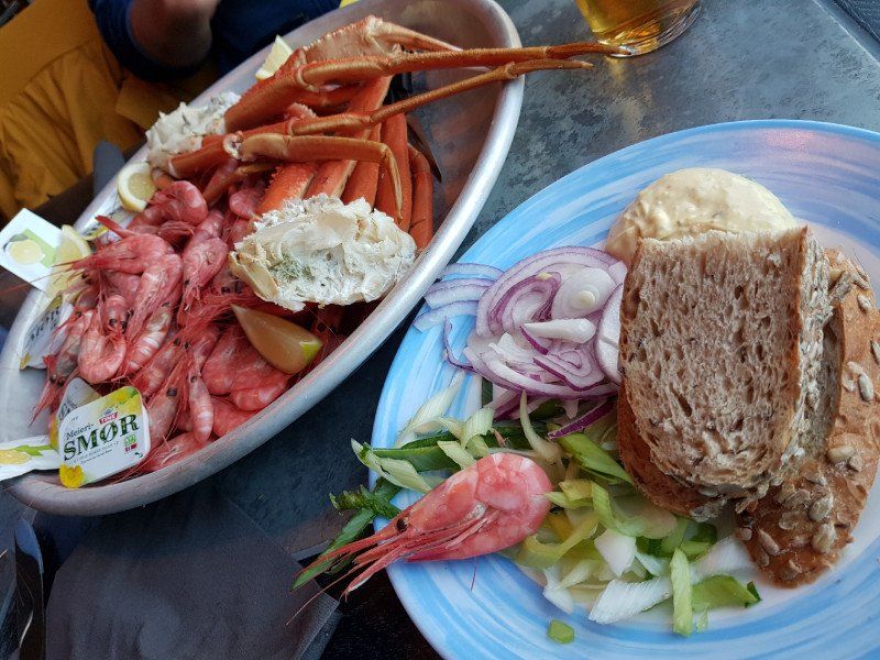
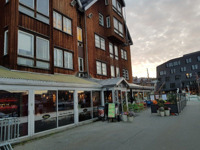
We came across the inconspicuous bar / bistro / music KAIA at the very bottom of the water near the Polar Museum.
On Thursday there are shrimps as much as you can eat for 20 sCHF or with claws (24 sCHF) ...
That was amazing. Very fresh straight from the polar sea and simply natural. Anytime to recommend.
There was bread, butter, onion rings, spring onions and a kind of garlic mayo.
We ate up to 1kg shrimp and a nice portion of prongs. (per person)
The service was very friendly and entertaining.
So we ended a multifaceted day with a typical Nordic meal that we won't soon forget.
Norwegen
69° 38' 57.1" N 18° 57' 19.2" E
69.6492047 18.9553238
• Head toward Grønnegata on Fredrik Langes gate. Go for 48 m.
• Turn left onto Grønnegata. Go for 79 m.
• Turn right onto Håkon den gamles gate. Go for 150 m.
• Turn left. Go for 202 m.
• Continue toward 862. Go for 29 m.
• Take the 1st exit from roundabout onto 862. Go for 842 m.
• Take the 3rd exit from roundabout onto 862. Go for 1.9 km.
• Take the 2nd exit from roundabout onto Kvaløyvegen (862/63). Go for 276 m.
• Take the 3rd exit from roundabout onto Kvaløyvegen (862). Go for 1.1 km.
• Pass 6 roundabouts and continue on Eidvegen (862). Go for 8.7 km.
• Turn right onto Fjordvegen (862). Go for 4.2 km.
• Turn left onto 862. Go for 380 m.
• Continue on Kattfjordeidet (862). Go for 11.1 km.
• Continue on 862. Go for 187 m.
• Turn left onto Synnøvjordvegen (862). Go for 5.6 km.
• Continue on Sjøtunvegen (862). Go for 6.7 km.
• Continue on Sandneshamnvegen (862). Go for 10.4 km.
• Turn left onto Brensholmvegen (862). Go for 1.4 km.
• Turn right onto Salvegen (862). Go for 762 m.
• Turn right onto 862. Go for 62 m.
• Continue on 862. Go for 136 m.
• Turn slightly left onto 862. Go for 210 m.
• Take the Brensholmen-Botnhamn Ferry. Stay on for 13.7 km.
• Head southwest on 862. Go for 221 m.
• Arrive at 862. Your destination is on the left.
☍
68,5 km
(1 hrs. 46 min.)
Day
Botnhamn
At around 9:00 am there is breakfast with a fresh, typical sourdough bread from Tromsö.
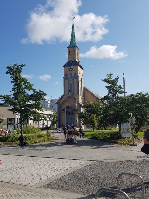
After a chat with a like-minded person (Aargauer) on the square, we make our way towards the Polar Museum.
In advance we try to change a few euros at the post office. Unfortunately it failed. There are no more banks and payments are ONLY always made by card. We heard about an exchange office where you can also send money.
We aim for that on the way back.
Yes the polar museum is worth it. Costs approx. CHF 10 per person.
After a while in the museum, it goes way back in time to the north. as also wanted to conquer the south pool fully with.
Is recommended.
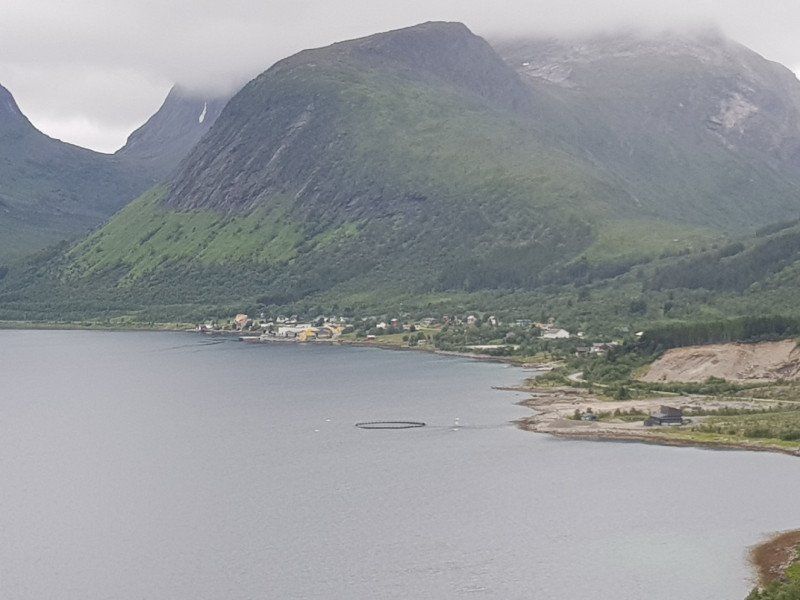
In the afternoon we start the journey towards the island of Senja.
We choose the longer route over land. There is also a shorter route where you can take a ferry.
In advance we are looking for a campsite with electricity and a shower.
We find Fjordbothn Camping.
From Tromsö 220km.
Norwegen
69° 30' 26.8" N 17° 54' 10.5" E
69.5074434 17.9029236
• Head west on 862.
• Turn left onto 862. Go for 138 m.
• Continue on Botnhamnveien (862). Go for 724 m.
• Continue on 862. Go for 24 m.
• Continue on Botnhamnveien (862). Go for 2.5 km.
• Continue on 862. Go for 63 m.
• Continue on Breidablikk (862). Go for 98 m.
• Continue on 862. Go for 452 m.
• Continue on Botnhamnveien (862). Go for 3.5 km.
• Turn right onto Stønesbotnveien (862). Go for 2.9 km.
• Continue on 862. Go for 14.7 km.
• Continue on Mefjordveien (862). Go for 1.8 km.
• Turn sharp left onto 862. Go for 13.2 km.
• Turn left onto Bergsfjordveien (862). Go for 9.8 km.
• Continue on 862. Go for 6.3 km.
• Turn right onto 86. Go for 6.5 km.
• Continue on Hamnveien (86). Go for 4.6 km.
• Turn slightly left onto Hamnveien (86). Go for 2.3 km.
• Continue on 86. Go for 4.1 km.
• Continue toward Fv86. Go for 1.1 km.
• Continue on Fv86. Go for 431 m.
• Turn right onto 86. Go for 2.3 km.
• Continue on Nerveien (86). Go for 949 m.
• Turn slightly right onto Spiraveien. Go for 489 m.
• Arrive at Spiraveien. Your destination is on the right.
☍
78,9 km
(2 hrs. 2 min.)
Day
Gryllefjord
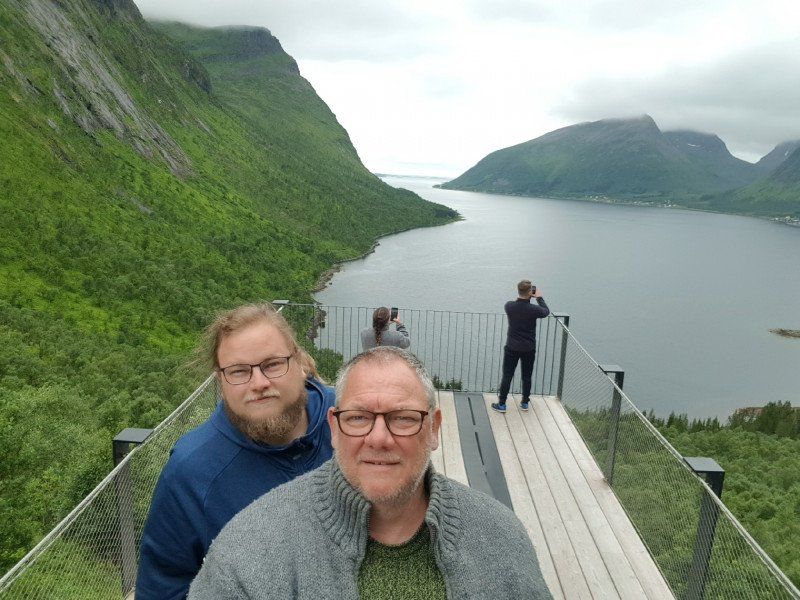
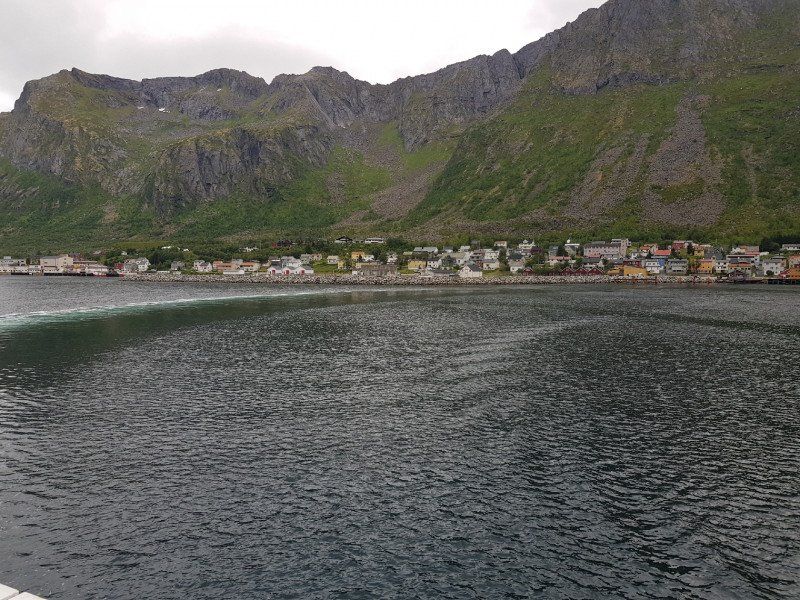
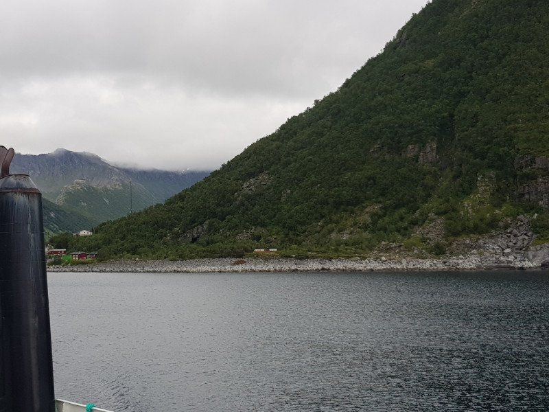
From Botnhamn we drive on the coastal road 861 and later the 864 and the final part on the 86 to Gryllefjord, where we tackle the ferry crossing to Andenes.
The route is very picturesque with a few special viewpoints for taking photos. Even if the sun is not shining, it gives a very nice impression.
In Gryllefjord we use the waiting time with a walk through the humble village.
We enter a small restaurant and treat ourselves to coffee and cake. It seems that you could also eat very well-prepared fish there.
To release the ticket.
Everything runs directly with the credit card .. then you pay the full price. (approx. 1700NOK including driver)
If you take a closer look and download a corresponding app, log in with the QR code, you buy a ticket for: 1265NOK including driver.
I think you can save yourself a few Frankli.
Norwegen
69° 21' 47.8" N 17° 2' 3.4" E
69.3632653 17.0342662
• Head east on Spiraveien. Go for 489 m.
• Turn slightly left onto Nerveien. Go for 221 m.
• Turn left onto Nerveien. Go for 48 m.
• Turn left onto Nerveien. Go for 19 m.
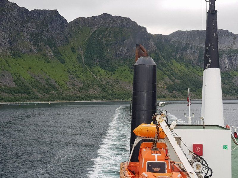
• Take the Gryllefjord-Andenes Ferry. Stay on for 37.0 km.
• Head west on 82. Go for 55 m.
• Turn slightly left onto Hamnegata (82). Go for 647 m.
• Turn slightly left onto Salbergs gate (82). Go for 328 m.
• Turn left onto Storgata (82). Go for 522 m.
• Arrive at Storgata (82). Your destination is on the left.
☍
39,3 km
(1 hrs. 31 min.)
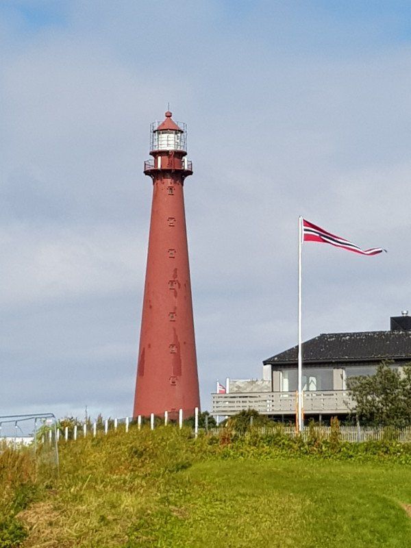
Andenes
Since we wrote a long report last night and it just didn't get dark, we didn't go to sleep until around 02:00.
So it happened that we had breakfast at 12:00 noon, and at around 3:00 pm we drove towards Gryllefjord. Everything outside along the coast on road 862, which in turn joins road 86 about 35km before Gryllefjord.
Narrow road, small tunnels but fantastic fjords, nature and wilderness ... highly recommended.
So we arrived at Gryllefjord around 5:00 p.m., where we took the ferry to Andenes. Departure 19:00.
Crossing Approx. 2 hours. We have an autopass box, which unfortunately is not valid for this crossing.
Pity.....
So we buy the ticket via an app, where we save another 20%.
Costs for our Womo 8-10m. approx. 1200 NOK plus 150 NOK per person
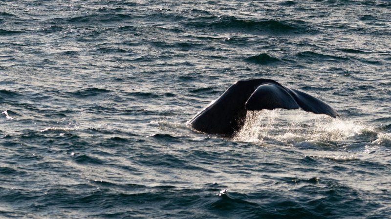
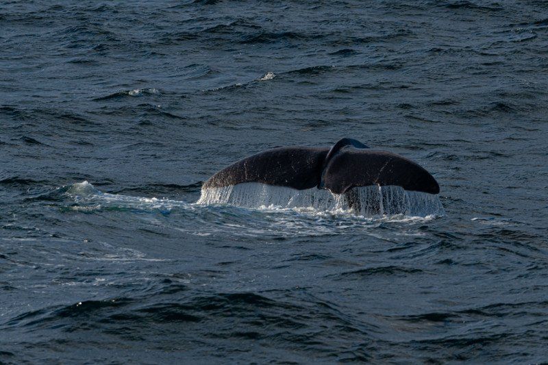
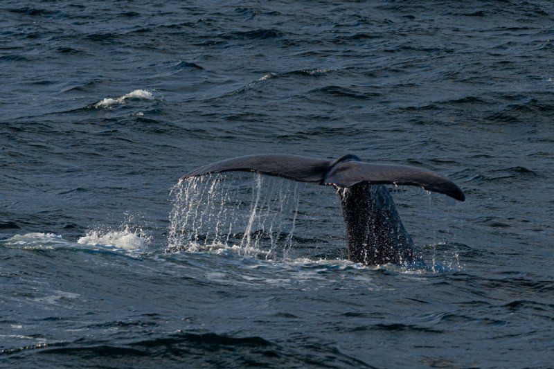
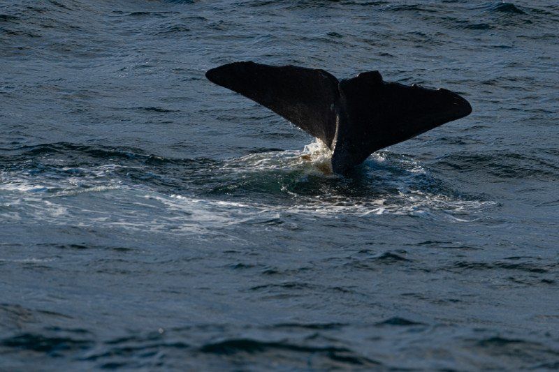
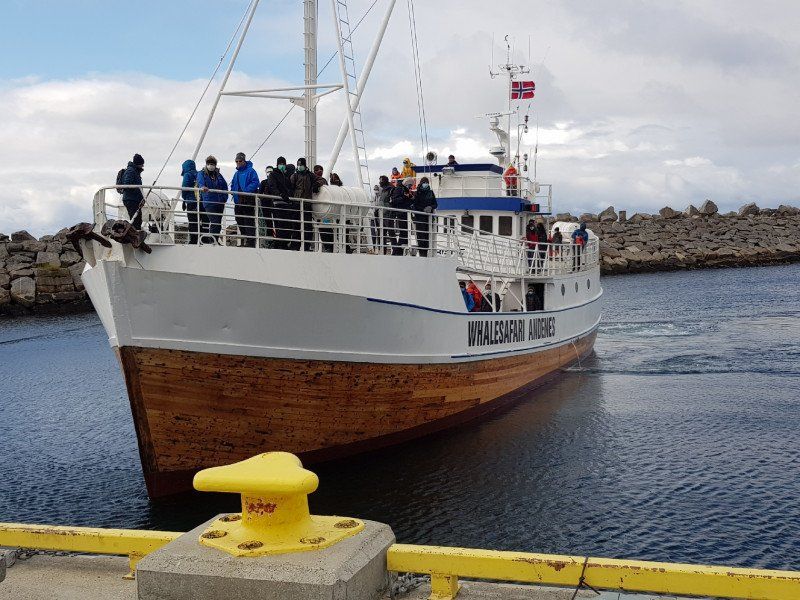
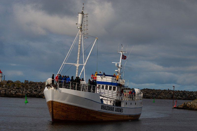
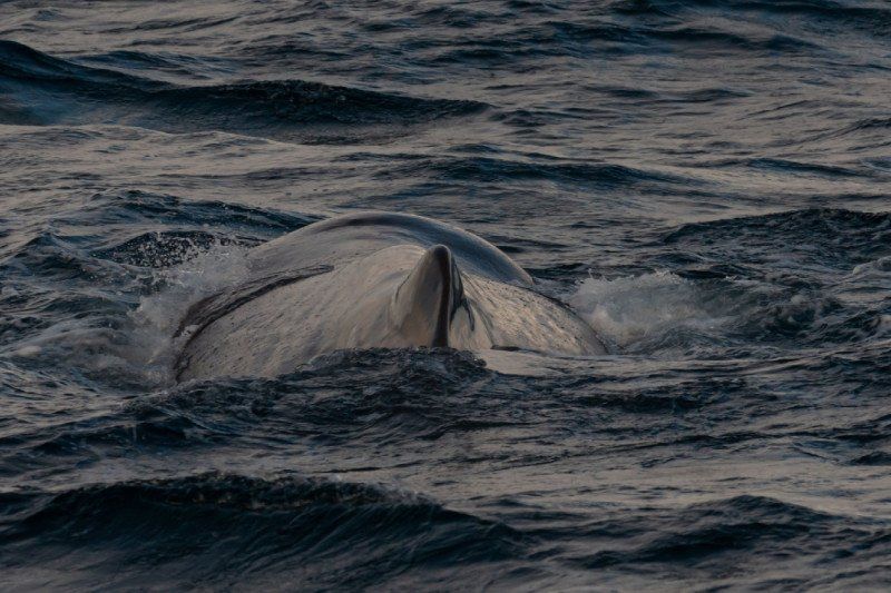
We decide to go whale watching in Andenes.
That is why we drive to the pitch with electricity, shower and toilet at the end of Andenes.
Norwegen
69° 18' 57.9" N 16° 7' 12.8" E
69.3160799 16.1202284
• Head south on Storgata (82).
• Arrive at Storgata (82). Your destination is on the left.
☍
Distance not available
(Duration not available)
Day
Andenes
After a quiet night, we enjoy breakfast outside in the sun, at a pleasant 14c.
After a long walk through Andenes, we position ourselves at 2:45 p.m. at the Check Inn for a whale sightseeing tour. per person 1160NOK.
an around 5h. Boat trip out to sea. With wind waves and about
8-10c .... it was a great experience.
you can see the rest in the pictures.
At around 9 p.m. we return and drive a little further to Maurnes. about 88km.
It is advisable to fill the fuel tank in Andenes, because it is a lot cheaper there than what is coming towards Lofoten.
Norwegen
69° 18' 57.9" N 16° 7' 12.8" E
69.3160799 16.1202284
• Head south on Storgata (82). Go for 440 m.
• Continue on Bleiksveien (82). Go for 3.3 km.
• Continue on 82. Go for 22.0 km.
• Continue on Sandmelra (82). Go for 94 m.
• Continue on Dverbergveien (82). Go for 4.4 km.
• Continue on 82. Go for 10.1 km.
• Continue on Torvhågveien (82). Go for 181 m.
• Continue on 82. Go for 14.7 km.
• Continue on Alset (82). Go for 101 m.
• Continue on 82. Go for 315 m.
• Continue on Toftar (82). Go for 102 m.
• Continue on 82. Go for 1.3 km.
• Continue on Godbakken (82). Go for 96 m.
• Continue on 82. Go for 1.5 km.
• Continue on Buksnes (82). Go for 139 m.
• Continue on 82. Go for 14.4 km.
• Continue on Reinsnesveien (82). Go for 14.5 km.
• Continue on Lilandveien (82). Go for 1.3 km.
• Turn left onto Lilandveien. Go for 26 m.
• Arrive at Lilandveien. Your destination is on the left.
☍
89,1 km
(1 hrs. 20 min.)
Maurnes
There is a very practical parking space here in Maurnes.
with electricity (150 NOK)
and for showers an extra 20 NOK.
Norwegen
68° 45' 9.7" N 15° 28' 24.2" E
68.7526982 15.4733843
• Head southwest on Lilandveien. Go for 26 m.
• Turn left onto Lilandveien (82). Go for 3.9 km.
• Continue on 82. Go for 430 m.
• Continue on Kringelveien (82). Go for 5.1 km.
• Continue on Strandveien (85). Go for 4.6 km.
• Continue on Kong Olavs vei (85). Go for 14.3 km.
• Turn right onto Våtvollveien (85). Go for 14.3 km.
• Take the 1st exit from roundabout onto E10. Go for 79.5 km.
• Take the 1st exit from roundabout onto Kong Olavs vei (E10). Go for 15.5 km.
• Turn left onto Henningsværveien (816). Go for 7.3 km.
• Turn slightly right onto Henningsværveien (816). Go for 109 m.
• Continue on Henningsværveien (816). Go for 245 m.
• Turn right onto Dreyers gate. Go for 30 m.
• Turn left onto Dreyers gate. Go for 292 m.
• Turn right onto Dreyers gate. Go for 265 m.
• Continue on Hellandsgata. Go for 500 m.
• Arrive at Hellandsgata.
☍
146,4 km
(2 hrs. 19 min.)
Day
Henningsvær
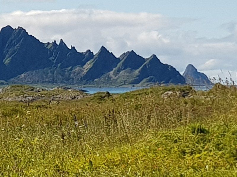
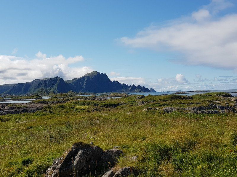
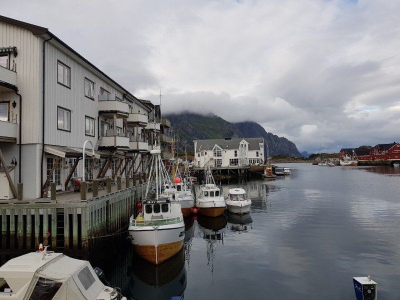
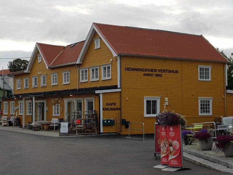
Yes, the trip to Henningsvaer was worth it.
At the junction immediately after about 100 meters you can see a small beach on the left at low tide.
The Norwegians go for a swim in 16c warm water.
If you follow the road, after crossing two bridges, you will come to the small village of Hanningwear.
Which extends over a couple of arms of the island.
A music festival is held here every year from August 2-4. We are just arriving on August 2nd.
That's why it's so busy with young people. Something is going on.
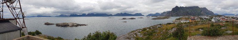
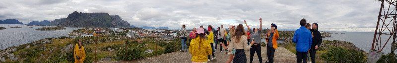
A small troupe from Oslo meets every year at the broadcast mast on the small plateau to dance in the mood.
It was a fun moment for us too.
The soccer field is located on another arm of the island. Exactly where we can see Lofoten in every picture.
Surrounded by the wooden scaffolding for drying and preserving the cod (stockfish)
We eat the well-known fish tatties and buy a little fresh salmon, which we then fry in the evening.
Norwegen
68° 9' 15.1" N 14° 12' 26.1" E
68.1541872 14.2072535
• Head toward Ole Juuls gate on Hellandsgata. Go for 500 m.
• Continue on Dreyers gate. Go for 340 m.
• Turn left onto Dreyers gate. Go for 17 m.
• Turn right onto Dreyers gate. Go for 226 m.
• Turn left onto Henningsværveien (816). Go for 7.7 km.
• Turn left onto Kong Olavs vei (E10). Go for 48.1 km.
• Turn right onto Leiteveien (7606). Go for 821 m.
• Continue on Leiteveien (7606). Go for 737 m.
• Turn right onto Vikveien. Go for 26 m.
• Turn slightly left onto Vikveien. Go for 2.8 km.
• Turn right onto Uttakleivveien (7716). Go for 702 m.
• Continue on 7716. Go for 1.3 km.
• Continue on Uttakleivveien (7716). Go for 349 m.
• Turn left onto Uttakleivveien. Go for 713 m.
• Arrive at Uttakleivveien.
☍
64,3 km
(1 hrs. 11 min.)
Uttakleivveien
Our overnight destination is Uttaklei Beach.
We drive over a very narrow road to the coast and find a very beautiful light beach there, as if we were in the Caribbean.
But that's not our goal yet. It goes through a tunnel (800m) until we reach Uttakleivveien on the other side.
There is an entrance with control on the beach. We pay 250 nok for an overnight stay. With this money this dreamlike place is kept clean and entertained.
It has toilet water and waste options. (No power connection.)
We try to put our motorhome upright on the hill and look forward to the fresh salmon, which we fry in olive oil with onions, olives and cherry tomatoes. There is also a rice. Barely cooked, this was a poem by candlelight.
After a digestive walk and a series of photos, we are tired enough to go to bed at midnight.
Leknes, Norwegen
68° 12' 33.7" N 13° 30' 22.5" E
68.2093476 13.5062552
• Head east on Uttakleivveien. Go for 713 m.
• Turn right onto Uttakleivveien (7716). Go for 349 m.
• Continue on 7716. Go for 1.3 km.
• Continue on Uttakleivveien (7716). Go for 702 m.
• Turn left onto Vikveien. Go for 2.8 km.
• Turn left onto Leiteveien (7606). Go for 737 m.
• Continue on Leiteveien (7606). Go for 821 m.
• Turn left onto Kong Olavs vei (E10). Go for 8.6 km.
• Arrive at Kong Olavs vei (E10). Your destination is on the left.
☍
16,0 km
( 20 min.)
Day
Borg
After our breakfast, we leave at around 10:30 am, back on the E10 and a few kilometers back to Borg.
Because the Vinking Museum opens there at 11:00.
Entry per person 225 nok.
We experience an exhibition with the finds that were made, then we visit the nave and can see how the Vikings lived in such a house. And also cooked over an open fire. Today there is vegetable soup.
Then we take a walk to the nearby lake, where we have the opportunity to take a lap in a Viking ship in a moderate wind. There are several other attractions that children especially like.
It was a worthwhile trip to go back to the Viking times for a moment.
Then we drive a few kilometers further south on the E10. Up to the Bukness Church.
Since this is currently being painted on the outside, there is unfortunately no way to see it from the inside.
So it stays with the outside view.
Norwegen
68° 14' 22.3" N 13° 44' 58.2" E
68.2395197 13.7495038
• Head southwest on Kong Olavs vei (E10). Go for 12.3 km.
• Pass 4 roundabouts and continue on Buksnesveien (E10). Go for 3.1 km.
• Turn right onto Flesveien (E10). Go for 18.7 km.
• Turn left onto Nusfjordveien (7596). Go for 6.2 km.
• Arrive at Nusfjordveien (7596). Your destination is on the right.
☍
40,3 km
( 42 min.)
Nusfjord
Yes, the historic fishing village of Nusfjord will shortly give you a very impressive insight into fishing from the 19th century and earlier.
With original disused craft houses that are still 1: 1 original. In this village everything needed for fishing was self-made.
really impressive. The picturesque little harbor with the houses on stilts, as well as the fishing ships, are ready for any camera.
In the evening mood (daylight) we still enjoy the view and eat a really fresh pizza with homemade smoked salmon and rocket in the only small restaurant. That was really a poem. With 2 draft beers (0.5 liters). It shows us once again that beer is absolutely too expensive in Norway. whole CHF 11:00.
Since the sky is more or less cloudy on this day too, we drive to Hamnöy and place the Schiltkrötli on a small gravel place between the road, bridge and water.
Norwegen
68° 2' 7.1" N 13° 20' 52.2" E
68.0353165 13.3478451
• Head south on Nusfjordveien (7596).
• Turn right onto Nusfjordveien (7596). Go for 12 m.
• Continue on Nusfjordveien. Go for 69 m.
• Turn right onto Nusfjordveien. Go for 94 m.
• Turn left onto Nusfjordveien (7596). Go for 6.1 km.
• Turn left onto Flakstadveien (E10). Go for 30.0 km.
• Turn right onto Hamnøya. Go for 191 m.
• Turn right onto Hamnøya. Go for 129 m.
• Arrive at Hamnøya. Your destination is on the right.
☍
36,6 km
( 39 min.)
Hamnøy
We meet a family from Germany on the small gravel parking lot (3 Womos). He is cleaning the mackerel.
I speak to him and he will tell you about his catch from today.
It wasn't the best day of catching, he says .... I'm amazed because I have about 30 stk. See mackerel in front of me.
With my amazement, he asks me if we would like some fresh mackerel.
You only have to ask us once.
So there is the following deal:
3 wonderful fresh mackerel, against 3 cans of anchor beer.
We are happy and he was happy.
We take a look at a small part of Hamnöy and end the day in a wonderful little restaurant with coffee, a visit to the toilet and a cold platter of anti pasta.
The night, which is still bright, begins with a lot of disapproval from the seagulls ...
Good night.
Norwegen
67° 56' 48.5" N 13° 7' 56.1" E
67.9468184 13.1322376
• Head south on Hamnøya. Go for 194 m.
• Turn right onto Kong Olavs vei (E10). Go for 8.4 km.
• Turn left onto Birger Eriksens vei (E10). Go for 360 m.
• Arrive at Birger Eriksens vei (E10). Your destination is on the right.
☍
9,0 km
( 12 min.)
Day
Moskenes
Norwegen
67° 54' 0.7" N 13° 2' 47.5" E
67.9001872 13.0465365
• Head south on Birger Eriksens vei (E10). Go for 28 m.
• Turn right onto Birger Eriksens vei (E10). Go for 127 m.
• Take the Moskenes-Bodø Ferry. Stay on for 96.9 km.
• Head east on Terminalveien (80). Go for 271 m.
• Turn right onto Terminalveien (80). Go for 32 m.
• Turn right onto Terminalveien (80). Go for 30 m.
• Take the 1st exit from roundabout onto Jernbaneveien (80). Go for 482 m.
• Take the 2nd exit from roundabout onto Jernbaneveien (80). Go for 145 m.
• Take the 3rd exit from roundabout onto Sjøgata (80). Go for 589 m.
• Take the 2nd exit from roundabout onto 80. Go for 698 m.
• Take the 1st exit from roundabout onto Sandhorngata. Go for 142 m.
• Turn right onto Gamle Riksvei. Go for 19 m.
• Turn left onto Sandhorngata. Go for 389 m.
• Arrive at Sandhorngata. Your destination is on the right.
☍
99,8 km
(3 hrs. 3 min.)
Bodø
Norwegen
67° 16' 49.3" N 14° 24' 17.7" E
67.2803556 14.4049160
• Head southwest on Sandhorngata.
• Turn left onto Børtindgata. Go for 227 m.
• Turn left onto Hålogalandsgata. Go for 382 m.
• Take the 2nd exit from roundabout onto Hålogalandsgata. Go for 460 m.
• Take the 1st exit from roundabout. Go for 111 m.
• Take the 2nd exit from roundabout onto 80. Go for 484 m.
• Pass 4 roundabouts and continue on 80. Go for 15.5 km.
• Take the 1st exit from roundabout onto 17. Go for 11.5 km.
• Turn right onto Kapstøveien. Go for 218 m.
• Turn right onto Kapstøveien. Go for 21 m.
• Arrive at Kapstøveien. Your destination is on the right.
☍
29,0 km
( 28 min.)
Pluscamp Saltstraumen
Knaplund 33, 8056, Saltstraumen, Norwegen
67° 14' 7.5" N 14° 37' 16.2" E
67.2354300 14.6211700
• Head northeast on Kapstøveien.
• Arrive at Kapstøveien. Your destination is on the right.
☍
Distance not available
(Duration not available)
Day
Pluscamp Saltstraumen
After a very pleasant night and a hearty breakfast, we use the large table to find out when the current (Straumen) is strongest, so that we can really experience this impressive natural water game.
Since 10:00 is already over at the latest, we can look forward to 16:07.
So we walk the car bridge to watch the water spectacle from above. It is very impressive what kind of water vortex it forms and pushes the water back to the surface at the edge.
The view from the side also gives an impression of hydropower.
This moment is especially ideal for the many fishermen to fish because it pushes the fish to the surface.
When we return to the Schilrkrötli around 6 p.m., we greet our new neighbors, a German family.
In conversation we find out that this family has just got our destination for tomorrow (Svartisen Glacier) behind them.
So we can plan our day and route correctly based on good tips.
which in turn means getting up early and driving off is a big advantage. The correct route choice to get the easiest way to one of the many glacier tongues and to find a parking space there.
So we throw on the grill again to grill our giant steak (for 2) with fried potatoes and beer.
We made very good progress today with photo editing and writing reports and can dive into the next bright night with a clear conscience. Because wake up is 6:00 am.
Knaplund 33, 8056, Saltstraumen, Norwegen
67° 14' 7.5" N 14° 37' 16.2" E
67.2354300 14.6211700
• Head southwest on Kapstøveien. Go for 21 m.
• Turn left onto Kapstøveien. Go for 218 m.
• Turn right onto Saltstraumveien (17). Go for 63.3 km.
• Turn right onto Forstrandveien (7444). Go for 1.5 km.
• Continue toward Skarveien. Go for 1.3 km.
• Continue on Skarveien. Go for 3.8 km.
• Turn right onto 17. Go for 21.3 km.
• Take the 2nd exit from roundabout onto Chr. Tidemanns vei (17). Go for 51.8 km.
• Turn left onto Kirkeveien (17) toward Steinkjer/Ågskardet. Go for 1.2 km.
• Arrive at Furøyveien (17).
☍
144,4 km
(2 hrs. 10 min.)
Day
Svartisen Gård
Norwegen
66° 42' 16.3" N 13° 43' 4.9" E
66.7045300 13.7180290
• Head toward Naustveien on Furøyveien (17). Go for 1.8 km.
• Take the Forøy-Ågskardet Ferry. Stay on for 2.7 km.
• Head toward Myranveien on Ågveien (17). Go for 28.1 km.
• Take the Jektvik-Kilboghamn Ferry. Stay on for 18.8 km.
• Head southwest on 17. Go for 23.7 km.
• Turn right onto 836. Go for 503 m.
• Turn left onto Selnesveien. Go for 9 m.
• Turn slightly left onto Selnesveien. Go for 282 m.
• Turn slightly left onto Selnesveien. Go for 148 m.
• Arrive at Selnesveien. Your destination is on the right.
☍
76,0 km
(2 hrs. 22 min.)
Halsa
8178, Norwegen
66° 44' 35" N 13° 33' 3.3" E
66.7430450 13.5509277
• Head west on Selnesveien. Go for 439 m.
• Turn right onto 836. Go for 503 m.
• Turn right onto Aldersundveien (17). Go for 35.2 km.
• Turn left onto Nesnaveien (12). Go for 31.7 km.
• Pass 2 roundabouts and continue on Nesnaveien (12). Go for 2.7 km.
• Take the 1st exit from roundabout onto Vikaåsen toward Sentrum. Go for 847 m.
• Take the 2nd exit from roundabout onto Vikaåsen. Go for 875 m.
• Take the 2nd exit from roundabout onto Ole Tobias Olsens gate. Go for 466 m.
• Take the 1st exit from roundabout onto Ole Tobias Olsens gate. Go for 391 m.
• Take the 1st exit from roundabout onto Ole Tobias Olsens gate. Go for 273 m.
• Take the 2nd exit from roundabout. Go for 83 m.
• Continue on Sørlandsveien. Go for 79 m.
• Continue on Ole Tobias Olsens gate. Go for 30 m.
• Take the 3rd exit from roundabout onto E6. Go for 95 m.
• Take the 1st exit from roundabout onto E6 toward Trondheim. Go for 37.7 km.
• Turn left onto Parkveien (806/321). Go for 149 m.
• Turn left onto Parkveien (7350). Go for 168 m.
• Turn left onto Nordfallet (7350). Go for 105 m.
• Continue on 7350. Go for 35 m.
• Continue on Nordfallet (7350). Go for 337 m.
• Turn right onto Markusmoveien. Go for 93 m.
• Turn slightly right onto Messaveien. Go for 80 m.
• Arrive at Messaveien. Your destination is on the right.
☍
112,4 km
(1 hrs. 35 min.)
Stokkvågen
Norwegen
66° 20' 9.3" N 13° 0' 38.6" E
66.3359044 13.0107211
• Head toward Seljeveien on Messaveien. Go for 80 m.
• Turn slightly left onto Markusmoveien. Go for 93 m.
• Turn left onto Nordfallet (7350). Go for 337 m.
• Continue on 7350. Go for 35 m.
• Continue on Nordfallet (7350). Go for 105 m.
• Turn right onto Parkveien (7350). Go for 168 m.
• Turn right onto Parkveien (806/321). Go for 149 m.
• Turn left onto Europavegen (E6). Go for 41.7 km.
• Take the 2nd exit from roundabout onto E6. Go for 4.3 km.
• Take the 2nd exit from roundabout onto E6 toward Trondheim. Go for 1.2 km.
• Take the 3rd exit from roundabout onto E6 toward Trondheim. Go for 264 km.
• Pass 7 roundabouts and continue on Steinkjervegen (E6). Go for 8.9 km.
• Keep left onto E6 toward Trondheim. Go for 29.6 km.
• Pass 2 roundabouts and continue on E6. Go for 21.5 km.
• Continue on E6. Go for 3.0 km.
• Take ramp. Go for 458 m.
• Take the 2nd exit from roundabout onto E6. Go for 3.1 km.
• Take the 1st exit from roundabout onto Breivegen (E6). Go for 9.8 km.
• Pass 5 roundabouts and continue on E6. Go for 32.0 km.
• Take ramp toward Vikhammer/Bostad. Go for 239 m.
• Turn left onto Leistadvegen (6706) toward Bostad. Go for 412 m.
• Turn right onto Markabygdvegen (6672). Go for 759 m.
• Turn right onto Markabygdvegen (6672). Go for 2.3 km.
• Continue toward Væresvegen/6672. Go for 21 m.
• Continue on 6672. Go for 280 m.
• Continue on Kjersti Wæhres veg (6672). Go for 148 m.
• Continue on Væresvegen (6672). Go for 874 m.
• Turn left onto Malvikvegen (950). Go for 1.5 km.
• Take the 2nd exit from roundabout. Go for 60 m.
• Continue on Kockhaugvegen (950). Go for 29 m.
• Take ramp onto E6 toward Trondheim. Go for 2.8 km.
• Take ramp onto 706 toward 715. Go for 4.3 km.
• Take the 2nd exit from roundabout onto 706 toward E6/Oslo/Havna/Sentrum. Go for 406 m.
• Take the 3rd exit from roundabout onto Havnegata (6692). Go for 398 m.
• Continue on Havnegata. Go for 16 m.
• Continue on Brattørbrua. Go for 33 m.
• Continue on Kjøpmannsgata. Go for 222 m.
• Turn right onto Olav Tryggvasons gate (6690). Go for 182 m.
• Turn left onto Søndre gate. Go for 336 m.
• Turn right onto Kongens gate. Go for 228 m.
• Arrive at Kongens gate. Your destination is on the right.
☍
435,6 km
(5 hrs. 43 min.)
Korgen
Norwegen
66° 4' 37.7" N 13° 48' 55.1" E
66.0771317 13.8153100
• Head toward Apotekerveita on Kongens gate. Go for 296 m.
• Turn right onto Kjøpmannsgata. Go for 171 m.
• Turn right onto Erling Skakkes gate. Go for 391 m.
• Turn left onto Prinsens gate (6690). Go for 3.6 km.
• Continue on E6. Go for 2.9 km.
• Keep left onto E6 toward Oslo/E39. Go for 7.4 km.
• Take exit 30 toward Ålesund/Orkanger/707/715. Go for 549 m.
• Take the 2nd exit from roundabout onto E39 toward Ålesund/Orkanger. Go for 26.8 km.
• Take the 1st exit from roundabout onto E39 toward Ålesund/710/714/Orkanger. Go for 120 m.
• Pass 3 roundabouts and continue on E39. Go for 2.9 km.
• Turn left onto E39 toward Ålesund/Frøya/714/Hitra. Go for 46.6 km.
• Turn left onto Vinjefjordsveien (E39) toward Ålesund/Kristiansund/Vinjeøra. Go for 43.4 km.
• Turn right onto Landvegen (E39) toward Ålesund/Kristiansund. Go for 7.3 km.
• Take the Halsa-Kanestraum Ferry. Stay on for 5.6 km.
• Head southwest on Straumsnesvegen (E39). Go for 8.8 km.
• Turn right onto Tingvollvegen (E39) toward Ålesund/Kristiansund. Go for 13.1 km.
• Take the 2nd exit from roundabout onto E39 toward Ålesund/Molde. Go for 1.7 km.
• Turn right onto 532 toward Gjemnes/Eide. Go for 2.7 km.
• Continue on Grønset (532). Go for 88 m.
• Continue on 532. Go for 285 m.
• Continue on Storlandsvegen (532). Go for 2.9 km.
• Continue on 532. Go for 715 m.
• Continue on Kolset (532). Go for 96 m.
• Continue on 532. Go for 3.6 km.
• Continue on Røysan (532). Go for 12 m.
• Continue on 532. Go for 907 m.
• Continue on Strandvegen (532). Go for 802 m.
• Continue on 532. Go for 411 m.
• Continue on Strandvegen (532). Go for 115 m.
• Continue on 532. Go for 626 m.
• Continue on Strandvegen (532). Go for 357 m.
• Continue on 532. Go for 770 m.
• Continue on Strandvegen (532). Go for 459 m.
• Continue on 532. Go for 671 m.
• Continue on Strandvegen (532). Go for 20 m.
• Continue on 532. Go for 130 m.
• Continue on Strandvegen (532). Go for 359 m.
• Continue on 532. Go for 84 m.
• Continue on Strandvegen (532). Go for 799 m.
• Continue on 532. Go for 892 m.
• Continue on Strandvegen (532). Go for 536 m.
• Continue on 532. Go for 70 m.
• Continue on Strandvegen (532). Go for 261 m.
• Continue on 532. Go for 132 m.
• Continue on Strandvegen (532). Go for 98 m.
• Continue on 532. Go for 2.7 km.
• Turn right onto Eidevegen (64). Go for 15.2 km.
• Turn right onto 64. Go for 2.5 km.
• Arrive at Atlanterhavsvegen (64).
☍
210,9 km
(3 hrs. 37 min.)
Day
Trondheim
Norwegen
63° 25' 49.9" N 10° 23' 42.2" E
63.4305149 10.3950528
• Head northeast on Atlanterhavsvegen (64). Go for 6.4 km.
• Turn left onto Kårvågveien (64). Go for 19.1 km.
• Take the 2nd exit from roundabout onto 64. Go for 9.5 km.
• Take the 1st exit from roundabout onto 64. Go for 242 m.
• Take the 1st exit from roundabout onto Kranaveien (539). Go for 777 m.
• Continue on Hollendergata (539). Go for 74 m.
• Continue on Fosnagata (539). Go for 319 m.
• Continue on Vågeveien (70). Go for 221 m.
• Turn right onto Kaibakken (70). Go for 277 m.
• Arrive at Kaibakken (70). Your destination is on the left.
☍
37,0 km
( 37 min.)
Atlantic Ocean Road
Vevang, Norwegen
63° 0' 42.8" N 7° 19' 16.5" E
63.0118985 7.3212509
• Head southwest on Kaibakken (70).
• Turn right onto Langveien (70). Go for 1.2 km.
• Continue on Wilhelm Dalls vei (70). Go for 573 m.
• Take the 1st exit from roundabout onto Wilhelm Dalls vei (70). Go for 1.7 km.
• Take the 3rd exit from roundabout onto Dalegata (70). Go for 1.8 km.
• Pass 2 roundabouts and continue on Nordmørsveien (70). Go for 3.0 km.
• Turn right onto Freikollveien (70). Go for 16.4 km.
• Take the 2nd exit from roundabout onto Tingvollvegen (E39). Go for 13.2 km.
• Continue on Tingvollvegen (70) toward Sunndalsøra/Tingvoll. Go for 45.9 km.
• Turn right onto 70 toward Sunndalsøra. Go for 18.9 km.
• Pass 2 roundabouts and continue on 70. Go for 68.4 km.
• Take the 3rd exit from roundabout onto Trondheimsvegen (E6) toward Trondheim. Go for 425 m.
• Take the 2nd exit from roundabout onto E6 toward Trondheim. Go for 24.0 km.
• Turn right onto Ulsberg (3) toward Elverum/Tynset. Go for 73.0 km.
• Turn left onto Nebyveien (30) toward Røros/Rendalen/Tynset sentrum. Go for 1.8 km.
• Take the 2nd exit from roundabout onto Rørosveien (30). Go for 20.8 km.
• Turn right onto Brugata (26) toward Drevsjø. Go for 97.3 km.
• Turn left onto Kopparleden (218) toward Mora/Idre/Sentrum. Go for 8.6 km.
• Continue on 70. Go for 2.3 km.
• Arrive at Flötningen (70). Your destination is on the left.
☍
399,3 km
(5 hrs. 38 min.)
Day
Kristiansund
Norwegen
63° 6' 37.2" N 7° 43' 41.1" E
63.1103346 7.7280790
• Head east on Flötningen (70). Go for 35.0 km.
• Turn right onto 70 toward Mora/Älvdalen/Särna/Idre Fjäll/Näset. Go for 113 km.
• Pass 3 roundabouts and continue on Älvgatan (70). Go for 39.5 km.
• Take the 2nd exit from Cirkulationsplats Stranden roundabout onto Vasagatan (E45) toward Östersund/Enköping/Sjukhus. Go for 370 m.
• Take the 2nd exit from Cirkulationsplats Resecentrum roundabout onto Vasagatan (E45). Go for 415 m.
• Take the 2nd exit from Cirkulationsplats Broåkern roundabout onto Vasagatan (E45). Go for 1.4 km.
• Take the 2nd exit from roundabout onto 70 toward Enköping. Go for 986 m.
• Pass 6 roundabouts and continue on Riksvägen (70). Go for 37.0 km.
• Turn left onto 69 toward Falun/Vidablick. Go for 41.9 km.
• Take the 3rd exit from roundabout onto Bergslagsdiagonalen (E16) toward Gävle/Fagersta/Söderhamn/Lugnet. Go for 2.6 km.
• Pass 5 roundabouts and continue on Korsnäsvägen (E16). Go for 8.6 km.
• Take ramp toward Hedemora. Go for 196 m.
• Continue on 69. Go for 37.4 km.
• Take the 3rd exit from roundabout onto 69/70 toward Fagersta/Enköping/Avesta. Go for 1.7 km.
• Take the 2nd exit from roundabout onto 69/70 toward Fagersta/Enköping. Go for 57.3 km.
• Take the 2nd exit from Evelunds Cirkulationsplats roundabout onto 56/70 toward Gävle/Enköping/Uppsala. Go for 3.5 km.
• Take the 1st exit from roundabout onto 70. Go for 38.7 km.
• Pass 2 roundabouts and continue on Salavägen (70). Go for 479 m.
• Take ramp onto E18 toward Stockholm/Uppsala. Go for 63.7 km.
• Take the exit onto E4/E18 (Uppsalavägen). Go for 3.3 km.
• Continue on E4 (Uppsalavägen) toward Stockholm/E20. Go for 15.7 km.
• Take exit 152 toward Sätra/Segeltorp onto Trafikplats Bredäng. Go for 386 m.
• Keep left onto Skärholmsvägen. Go for 958 m.
• Turn right onto Bredängs allé. Go for 52 m.
• Turn left onto Eksätravägen. Go for 188 m.
• Turn slightly right onto Björksätravägen. Go for 356 m.
• Turn right onto Ålgrytevägen. Go for 508 m.
• Turn left onto Stora Sällskapets väg. Go for 167 m.
• Arrive at Stora Sällskapets väg. Your destination is on the right.
☍
505,0 km
(6 hrs. 2 min.)
Flötningen
Schweden
61° 51' 41.3" N 12° 13' 3.9" E
61.8614808 12.2177411
• Head toward Ålgrytevägen on Stora Sällskapets väg. Go for 602 m.
• Turn left onto Bredängs allé. Go for 65 m.
• Continue on Bredängsvägen. Go for 1.7 km.
• Take ramp onto E4/E20 (Södertäljevägen) toward Sundsvall/Stockholm C. Go for 3.2 km.
• Take exit 154 toward Södermalm/Liljeholmen onto Södertäljevägen. Go for 3.1 km.
• Continue on Liljeholmsbron. Go for 358 m.
• Turn right onto Hornsgatan toward Skanstull/Medborgarplatsen/Södersjukhuset. Go for 2.3 km.
• Continue on Slussbron. Go for 209 m.
• Continue on Skeppsbron. Go for 754 m.
• Turn left onto Slottskajen. Go for 134 m.
• Turn right onto Norrbro. Go for 216 m.
• Turn left onto Gustav Adolfs torg. Go for 29 m.
• Arrive at Gustav Adolfs torg. Your destination is on the right.
☍
12,7 km
( 18 min.)
Day
Bredäng Camping Stockholm
Stora Sällskapetsväg 60, 12731, Skärholmen, Schweden
59° 17' 43.8" N 17° 55' 23.8" E
59.2954900 17.9232900
• Head toward Strömgatan on Gustav Adolfs torg. Go for 29 m.
• Turn right onto Norrbro. Go for 216 m.
• Turn left onto Slottskajen. Go for 128 m.
• Turn slightly right onto Skeppsbron. Go for 736 m.
• Continue on Slussbron. Go for 195 m.
• Continue on Hornsgatan. Go for 2.3 km.
• Turn left onto Långholmsgatan toward E4 S/E20S/Liljeholmen. Go for 352 m.
• Continue on Södertäljevägen. Go for 1.4 km.
• Take left ramp onto E4/E20 (Södertäljevägen) toward Helsingborg/Göteborg. Go for 27.3 km.
• Continue on E4 (Trafikplats Saltskog östra) toward Helsingborg/Nyköping. Go for 290 km.
• Take exit 95B toward Helsingborg/Växjö onto E4. Go for 223 km.
• Take exit 30 toward Helsingborg S/Malmö onto E4/E6/E20. Go for 8.0 km.
• Continue on E6/E20 (Trafikplats Helsingborg S). Go for 64.4 km.
• Take exit 12 toward Trelleborg onto E6/E22 (Trelleborgsvägen). Go for 20.9 km.
• Take the 2nd exit from roundabout onto E6/E22 toward Trelleborg. Go for 2.9 km.
• Turn right onto Strandridaregatan. Go for 65 m.
• Turn right onto Stavstensvägen. Go for 124 m.
• Arrive at Stavstensvägen. Your destination is on the left.
☍
642,1 km
(5 hrs. 59 min.)
Day
Stockholm
Schweden
59° 19' 45.6" N 18° 4' 6.9" E
59.3293235 18.0685808
• Head toward Strandridaregatan on Stavstensvägen. Go for 124 m.
• Turn left onto Strandridaregatan. Go for 65 m.
• Turn right onto E6/E22. Go for 928 m.
• Continue on Slussgatan (9). Go for 1.4 km.
• Turn right onto Kontinentgatan. Go for 40 m.
• Continue on Kontinentplan. Go for 10 m.
• Arrive at Kontinentplan.
☍
2,6 km
( 4 min.)
Day
Rastplats Trelleborg
Strandridaregatan, 23132, Trelleborg, Schweden
55° 22' 31" N 13° 7' 14" E
55.3752778 13.1205556
• Head south on Kontinentplan.
• Arrive at Kontinentplan.
☍
Distance not available
(Duration not available)
Kontinentplan
Trelleborg, Schweden
55° 22' 19.4" N 13° 9' 30.2" E
55.3720657 13.1583859
Day
Kontinentplan
Trelleborg, Schweden
55° 22' 19.4" N 13° 9' 30.2" E
55.3720657 13.1583859