To also make a tour in the winter months, we travel to southern Portugal and the south of Spain, and of course we take Gibraltar with us.
Day
Lith, Nederland
Zuster Allegondastraat 9, 5397 BN Lith, Nederland
51° 48' 26.8" N 5° 26' 15.2" E
51.8074428 5.4375508
• Head toward Pastoor van Hapertstraat on Zuster Allegondastraat. Go for 61 m.
• Turn left onto Pastoor van Hapertstraat. Go for 210 m.
• Continue on Kapelstraat. Go for 243 m.
• Turn right onto Meester van Coothstraat (N625). Go for 2.7 km.
• Take the 2nd exit from roundabout onto Provincialeweg (N625). Go for 8.6 km.
• Continue on De Blauwe Sluisweg. Go for 443 m.
• Pass 2 roundabouts and continue on De Blauwe Sluisweg (N625). Go for 851 m.
• Keep right toward De Blauwe Sluisweg/N625. Go for 54 m.
• Take the 2nd exit from roundabout onto De Blauwe Sluisweg (N625). Go for 870 m.
• Keep right toward Waalwijk/Utrecht/Eindhoven/'s-Hertogenbosch. Go for 34 m.
• Take the 1st exit from roundabout onto Bruistensingel toward Waalwijk/Utrecht/Eindhoven/'s-Hertogenbosch. Go for 371 m.
• Turn left toward Waalwijk/Utrecht/Industrieterrein 3700-3900. Go for 207 m.
• Turn right and take ramp onto A2/A59 (Ring 's-Hertogenbosch) toward Waalwijk/Utrecht. Go for 1.1 km.
• Take the exit toward Ring-Noord/Waalwijk onto A59 (Ring 's-Hertogenbosch). Go for 32.6 km.
• Keep left toward Oosterhout/Breda. Go for 263 m.
• Turn slightly left and take ramp onto A27. Go for 16.1 km.
• Take the exit toward Roosendaal/Antwerpen/Industrieterrein Breda 0-7000 onto A58. Go for 6.3 km.
• Take the left exit toward E19/Antwerpen onto A16. Go for 5.9 km.
• Continue on E19. Go for 34.0 km.
• Take the exit toward Ring 2/Brugge/Bergen op Zoom/Haven/Centrum Noord onto A12 (Antwerpen-Noord). Go for 2.1 km.
• Take exit 16 toward Centrum Noord/Haven 1-490/Ekeren/Haven 1-100 onto N180 (Noorderlaan). Go for 5.0 km.
• Turn left onto IJzerlaan (N1). Go for 2.4 km.
• Turn left and take ramp onto E19 (Ring Antwerpen 1). Go for 2.2 km.
• Continue on E19 (Ring Antwerpen 1). Go for 2.4 km.
• Continue on E34 (Kleine Ring) toward Brugge/Gent/Haven 1000-2000. Go for 5.2 km.
• Continue on E17. Go for 101 km.
• Continue on A22. Go for 11.7 km.
• Keep left onto N356 toward Paris/A1/Lille/Aéroport Lille Lesquin. Go for 4.8 km.
• Keep left onto N356 toward Paris/Dunkerque/Lille-Centre/Aéroport Lesquin. Go for 1.7 km.
• Keep left onto Boulevard Périphérique Est de Lille (N356) toward Paris/Bruxelles/Valenciennes/Villeneuve d'Ascq/Aéroport Lesquin. Go for 411 m.
• Take ramp onto A1 (Autoroute du Nord). Go for 20.5 km.
• Keep left onto A1 (Autoroute du Nord). Go for 174 km.
• Take the exit toward Bordeaux/A10/Nantes/Bobigny onto A3 (Échangeur de Garonor). Go for 17.8 km.
• Take the left exit onto Boulevard Périphérique. Go for 7.8 km.
• Take ramp onto A6 B toward A10/Bordeaux/Nantes/Lyon/Évry/Aéroport Orly-Rungis. Go for 9.7 km.
• Keep right onto A10 toward E05/Palaiseau/Étampes/Bordeaux/Nantes/Antony-Z.A./Massy/Longjumeau. Go for 3.5 km.
• Take the exit toward Nantes/A11/Bordeaux/Orléans/Palaiseau onto A10. Go for 553 km.
• Take exit 1 toward Toulouse/Bayonne/Bassin d'Arcachon/Bordeaux/Périgueux onto N230 (Rocade de Bordeaux). Go for 19.8 km.
• Take exit 15 toward Saint Sébastien/Bayonne/Mont de Marsan/Bassin d'Arcachon onto A63. Go for 206 km.
• Continue on AP-8 (Autopista del Cantábrico). Go for 11.0 km.
• Take exit 11 toward Oiartzun/Errenteria. Go for 475 m.
• Continue on Camino a Oreta (GI-2134). Go for 153 m.
• Take the 1st exit from roundabout onto GI-2132 toward Errenteria/N-1/Donostia/S. Sebastián/Irun. Go for 237 m.
• Keep right onto Barrio Larzabal toward GI-636/Irun/Frantzia. Go for 147 m.
• Continue on Camino Lartzabalzarra. Go for 230 m.
• Take the 1st exit from roundabout onto GI-636 toward Irun/Frantzia. Go for 674 m.
• Turn right onto N-1. Go for 23 m.
• Turn right onto N-1. Go for 35 m.
• Arrive at N-1. Your destination is on the left.
☍
1,275,6 km
(11 hrs. 45 min.)
Camping Oliden
Ctra N-1 km 470, 20013, Errenteria, Spain
43° 18' 55.5" N 1° 52' 27.5" W
43.3154100 -1.8743000
• Head east on N-1. Go for 57 m.
• Turn right onto N-1. Go for 197 m.
• Turn slightly left onto Camino Lartzabalzarra. Go for 67 m.
• Turn right onto Camino Lartzabalzarra. Go for 621 m.
• Turn right onto Camino Lartzabalzarra. Go for 89 m.
• Turn right toward Camino Lartzabalzarra. Go for 67 m.
• Take the 3rd exit from roundabout onto Camino Lartzabalzarra toward GI-2132/Oiartzun/A-8. Go for 388 m.
• Take the 4th exit from roundabout onto GI-2132 toward Oiartzun/A-8. Go for 418 m.
• Take the 2nd exit from roundabout onto GI-2132 toward Astigarraga/A-8/Donostia/S. Sebastián/GI-3031/Ugaldetxo/Iturriotz. Go for 309 m.
• Take the 1st exit from roundabout onto AP-1/AP-8 toward Donostia/San Sebastián/Bilbao/Vitoria/Gasteiz/Hernani/A-15/Iruña/Pamplona. Go for 15.5 km.
• Take the exit onto AP-1/AP-8 (Autopista del Cantábrico). Go for 41.9 km.
• Continue on AP-8 (Autopista del Cantábrico) toward Eibar/Bilbao. Go for 34.2 km.
• Take exit 103 toward N-637/Aireportua/Centro Ciudad Bilbao/Barakaldo/Getxo onto BI-30. Go for 9.9 km.
• Take exit 18 toward Bilbao onto BI-631. Go for 3.1 km.
• Take ramp onto Carretera Artxanda-Santo Domingo (BI-3732). Go for 506 m.
• Take the 1st exit from roundabout onto Carretera Enekuri-Artxanda (BI-3741) toward Artxanda/Enekuri. Go for 465 m.
• Take the 2nd exit from roundabout onto Carretera Enekuri-Artxanda (BI-3741). Go for 467 m.
• Turn right. Go for 31 m.
• Arrive at your destination on the left.
☍
108,2 km
(1 hrs. 8 min.)
Bilbo, Spanje
Carretera Artxanda-Santo Domingo Errepidea, 27, 48015 Bilbo, Bizkaia, Spanje
43° 16' 27" N 2° 55' 12.4" W
43.2741716 -2.9201073
• Head toward Carretera Enekuri-Artxanda. Go for 31 m.
• Turn right onto Carretera Enekuri-Artxanda (BI-3741). Go for 474 m.
• Take the 3rd exit from roundabout onto Carretera Enekuri-Artxanda (BI-3741). Go for 989 m.
• Pass 2 roundabouts and continue on Carretera Enekuri-Artxanda (BI-3741). Go for 853 m.
• Take ramp onto Carretera Ibarsusi-Santo Domingo (BI-631). Go for 3.2 km.
• Take the 2nd exit from roundabout. Go for 54 m.
• Turn right onto Carretera Bilbao Galdakao (N-634). Go for 801 m.
• Take the 1st exit from roundabout onto Avenida Miraflores (N-634) toward Erdialdea/Centro Urbano. Go for 768 m.
• Take the 1st exit from roundabout onto BI-631 (Viaducto Miraflores Larreagaburu) toward E-70/Bilbao/A-8. Go for 1.0 km.
• Take the left exit toward Donostia/San Sebastián/AP-68/Vitoria-Gasteiz onto A-8 (Autovía del Cantábrico). Go for 2.5 km.
• Keep right onto AP-68 (Autopista del Ebro) toward Vitoria-Gasteiz/Burgos. Go for 68.0 km.
• Take exit 7 toward E-5/Burgos/AP-1/Vitoria-Gasteiz onto E-804. Go for 1.0 km.
• Take the exit toward Vitoria/Gasteiz onto AP-1 (Autovía del Norte). Go for 77.0 km.
• Continue on A-1 (Autovía del Norte) toward Madrid/A-62/Valladolid/Portugal. Go for 7.1 km.
• Keep right onto BU-30 (Nudo de Landa) toward Palencia/Valladolid/A-62/León/A-231. Go for 4.2 km.
• Take the exit toward Burgos (Oeste)/N-120/N-120/León/A-231/Santander/A-73/Polígono Industrial de Villalonquéjar onto BU-30. Go for 4.7 km.
• Keep left onto BU-30 toward León/A-231/Burgos (Oeste)/N-120/Villalbilla de Burgos/Tardajos/Polígono Industrial de Villalonquéjar. Go for 1.4 km.
• Continue on A-231 toward Villanueva de Argaño/León. Go for 110 km.
• Take exit 46 toward Camino de Santiago onto Avenida Sahagún. Go for 476 m.
• Turn right onto N-120. Go for 13.1 km.
• Continue on Carretera de Burgos (N-120). Go for 374 m.
• Continue on N-120. Go for 6.9 km.
• Continue on Carretera Castrovega (N-120). Go for 249 m.
• Continue on N-120. Go for 1.4 km.
• Turn right onto N-601. Go for 4.0 km.
• Turn left onto LE-521 toward Matadeón/Valencia de Don Juan. Go for 3.9 km.
• Continue on Carretera Valencia (LE-521). Go for 411 m.
• Continue on LE-521. Go for 12.7 km.
• Continue on Avenida Matallana (LE-521). Go for 191 m.
• Take the 3rd exit from roundabout onto Avenida del Rey Juan Carlos I (LE-512). Go for 351 m.
• Take the 1st exit from roundabout onto Avenida de Asturias (CL-621). Go for 1.5 km.
• Turn left onto CV-232-18. Go for 2.4 km.
• Continue on Avenida Valencia. Go for 1.2 km.
• Continue on Camino Cementerio. Go for 860 m.
• Continue on Calle Real. Go for 2.5 km.
• Continue on Carretera Valencia D. Juan. Go for 292 m.
• Continue on Carretera Valencia. Go for 154 m.
• Take the 2nd exit from roundabout. Go for 1.8 km.
• Take the 2nd exit from roundabout. Go for 132 m.
• Take the 2nd exit from roundabout onto A-66 (Autovía Ruta de la Plata) toward Benavente. Go for 22.7 km.
• Continue on A-52 (Autovía de las Rías Bajas) toward Puebla de Sanabria/Ourense/VIgo. Go for 96.3 km.
• Arrive at Autovía de las Rías Bajas (A-52).
☍
458,6 km
(4 hrs. 8 min.)
San Martín del Terroso, Spanje
367F+9CG San Martín del Terroso, Spanje
42° 3' 48.4" N 6° 46' 35.1" W
42.0634403 -6.7764187
• Head west on A-52 (Autovía de las Rías Bajas). Go for 3.8 km.
• Take exit 99 toward Padornelo/Puebla de Sanabria. Go for 391 m.
• Continue on N-525. Go for 110 m.
• Take left ramp onto A-52 (Autovía de las Rías Bajas) toward Puebla de Sanabria/Zamora/Benavente. Go for 6.9 km.
• Take exit 92 toward N-525/Requejo. Go for 851 m.
• Take the 2nd exit from roundabout onto Calle Carretera (N-525) toward Puebla de Sanabria. Go for 2.2 km.
• Turn right toward Calle Santa Lucía. Go for 1.6 km.
• Continue on Calle Santa Lucía. Go for 532 m.
• Turn right onto Calle Santa Lucía. Go for 18 m.
• Continue on Calle Santa Lucía. Go for 376 m.
• Turn right onto Carretera de Portugal (ZA-925). Go for 14.5 km.
• Continue on N103-7. Go for 5.1 km.
• Turn sharp left onto Rua da Pedrica (M501). Go for 378 m.
• Continue on M501. Go for 4.9 km.
• Turn sharp right. Go for 1.9 km.
• Arrive at your destination.
☍
43,5 km
( 56 min.)
V7MP+84 Aveleda, Portugal
41° 53' 0.1" N 6° 42' 53" W
41.8833691 -6.7147119
• Head north. Go for 1.9 km.
• Turn slightly right onto M501. Go for 63 m.
• Turn left onto M501. Go for 4.7 km.
• Continue on N218-3. Go for 4.7 km.
• Continue on Estrada do Aeródromo (N218-3). Go for 256 m.
• Continue on N218-3. Go for 911 m.
• Turn right onto N218. Go for 2.1 km.
• Take the 2nd exit from roundabout onto Avenida Cidade de Zamora (N218). Go for 670 m.
• Keep left toward Avenida Cidade de Zamora. Go for 28 m.
• Take the 2nd exit from roundabout onto Avenida Cidade de Zamora. Go for 147 m.
• Continue on Rua Emídio Navarro. Go for 310 m.
• Turn left onto Rua Nova do Cemitério. Go for 33 m.
• Turn right onto Avenida João da Cruz. Go for 47 m.
• Make a U-Turn onto Avenida João da Cruz. Go for 61 m.
• Continue on Rua 5 de Outubro. Go for 211 m.
• Continue on Rua Alexandre Herculano. Go for 566 m.
• Take the 1st exit from Rotunda Flor da Ponte roundabout onto Alameda de Santa Apolónia. Go for 389 m.
• Turn left onto Rua Marechal Carmona. Go for 354 m.
• Continue on Estrada do Turismo (N217). Go for 232 m.
• Turn left onto Rua João de Barros. Go for 532 m.
• Turn right onto Rua Senhor dos Perdidos. Go for 329 m.
• Turn left onto Estrada de São Bartolomeu. Go for 1.1 km.
• Arrive at Estrada de São Bartolomeu.
☍
19,6 km
( 38 min.)
Bragança, Portugal
BRAGANÇA Hidden within the old city walls is a medieval village. Includes pillory, citadel and thick entrance gates.
Q7W3+933 Bragança, Portugal
41° 47' 45.2" N 6° 44' 50.4" W
41.7958881 -6.7473221
• Head toward Rua Senhor dos Perdidos on Estrada de São Bartolomeu. Go for 1.1 km.
• Turn left onto Rua Senhor dos Perdidos. Go for 212 m.
• Turn right onto N217-1. Go for 956 m.
• Take the 3rd exit from roundabout onto N217. Go for 1.5 km.
• Take the 1st exit from roundabout. Go for 607 m.
• Take the 2nd exit from roundabout onto A4 (Autoestrada Transmontana) toward Espanha. Go for 21.4 km.
• Continue on N-122. Go for 28.7 km.
• Turn right onto Carretera de Portugal toward Moveros/Miranda do Douro. Go for 2.7 km.
• Continue on Calle Real. Go for 2.6 km.
• Continue on M1201. Go for 1.7 km.
• Turn left onto M542. Go for 4.3 km.
• Continue on Rua de São Sebastião (M542). Go for 1.0 km.
• Continue on Largo de Margalho (M542). Go for 125 m.
• Continue on Rua de São Roque (M542). Go for 1.2 km.
• Turn left onto M542. Go for 4.0 km.
• Arrive at M542. Your destination is on the left.
☍
72,2 km
( 57 min.)
GPMM+W7 Ifanes, Portugal
41° 32' 5.5" N 6° 16' 0.3" W
41.5348610 -6.2667538
• Head southwest on M542. Go for 3.7 km.
• Continue on Rua dos Adis (M542). Go for 363 m.
• Continue on Rua 1 de Maio (M542). Go for 407 m.
• Turn right onto Rua 25 de Abril (M542). Go for 32 m.
• Turn right onto N218. Go for 1.4 km.
• Take the 3rd exit from roundabout onto N221. Go for 5.7 km.
• Keep left onto IC5. Go for 36.5 km.
• Take ramp toward Mogadouro/N221/Vimioso/N219. Go for 210 m.
• Take the 3rd exit from roundabout onto N221. Go for 1.8 km.
• Arrive at Avenida de Salamanca (N221). Your destination is on the left.
☍
50,1 km
( 33 min.)
Campismo Municipal de Mogadouro
5200-240, Mogadouro, Portugal
41° 20' 31.1" N 6° 42' 35.5" W
41.3419600 -6.7098500
• Head toward Largo São Cristo on Avenida de Salamanca (N221). Go for 88 m.
• Take the 3rd exit from roundabout onto Largo São Cristo (N221). Go for 1.9 km.
• Take the 1st exit from roundabout onto IC5 toward Vila Flor/Alfândega Fé. Go for 46.1 km.
• Take ramp onto IP2 toward Bragança/M. de Cavaleiros/Vila Flôr. Go for 3.3 km.
• Take ramp onto IC5 toward Vila Flor. Go for 49.7 km.
• Take ramp onto A4 (Autoestrada Transmontana) toward Bragança/Porto/Vila Real. Go for 95.1 km.
• Take exit 9A toward Gondomar/A43/Lisboa/(A1) onto A41 (CREP). Go for 15.3 km.
• Take exit 16 toward Medas. Go for 601 m.
• Take the 2nd exit from roundabout onto Avenida Central Vila Cova (N108) toward Entre-os-Rios/Medas. Go for 398 m.
• Turn right onto Rua Luís de Camões (M615) toward Pombal. Go for 1.5 km.
• Continue on Rua do Presinho (M615). Go for 1.0 km.
• Turn right onto Rua do Presinho (M615). Go for 12 m.
• Continue on Rua da Aldeia (M615). Go for 66 m.
• Arrive at Rua da Aldeia (M615). Your destination is on the left.
☍
215,0 km
(2 hrs. 9 min.)
Parque de Campismo Campidouro
Parque de Camp. de Medas, 4515-397, Medas, Portugal
41° 3' 32.8" N 8° 25' 53.9" W
41.0591000 -8.4316400
• Head northwest on Rua da Aldeia (M615). Go for 66 m.
• Continue on Rua do Presinho (M615). Go for 1.0 km.
• Continue on Rua Luís de Camões (M615). Go for 1.5 km.
• Turn left onto Rua Central de Vila Cova (N108). Go for 356 m.
• Take the 3rd exit from roundabout onto A41 (CREP) toward Norte e Este. Go for 3.6 km.
• Take exit 15 toward Porto (Freixo)/Gondomar onto A43 (Autoestrada Radial de Gondomar). Go for 8.3 km.
• Take exit 6 toward Gondomar Este/N2019-1/Valongo/Rio Tinto. Go for 613 m.
• Take the 4th exit from roundabout onto Estrada de Dom Miguel toward Rio Tinto/Valongo. Go for 326 m.
• Take ramp onto Estrada de Dom Miguel toward Porto/Gondomar/S. Pedro da Cova. Go for 90 m.
• Take the 3rd exit from roundabout onto Rua Doutor Francisco Sá Carneiro (N209). Go for 730 m.
• Take the 3rd exit from roundabout onto Avenida da Conduta. Go for 585 m.
• Take the 3rd exit from roundabout onto Avenida da Conduta. Go for 262 m.
• Take the 2nd exit from roundabout onto Avenida Doutor Mário Soares. Go for 497 m.
• Take the 2nd exit from Rotunda Centro Ciclista de Gondomar roundabout onto Avenida da Conduta. Go for 667 m.
• Continue toward Travessa de Manariz de Baixo. Go for 29 m.
• Take the 1st exit from roundabout onto Travessa de Manariz de Baixo. Go for 541 m.
• Continue on Avenida da Conduta. Go for 432 m.
• Take the 2nd exit from roundabout onto Avenida da Conduta toward Porto/Rio Tinto/Valongo. Go for 455 m.
• Continue on Avenida Doutor Mário Soares. Go for 9 m.
• Continue on Avenida da Conduta. Go for 26 m.
• Take the 1st exit from roundabout onto Rua de Cabanas. Go for 397 m.
• Arrive at Rua de Cabanas. Your destination is on the left.
☍
20,6 km
( 20 min.)
R. Cabanas 88, 4510-506 Fânzeres, Portugal
41° 10' 6.4" N 8° 32' 11.9" W
41.1684379 -8.5366500
• Head toward Rua da Tardinhade on Rua de Cabanas. Go for 77 m.
• Continue on Rua do Outeiro. Go for 86 m.
• Turn left onto Rua do Outeiro. Go for 152 m.
• Turn right onto Rua Abade Pinto Outeiro (M612-1). Go for 67 m.
• Continue on Rua da Igreja (M612-1). Go for 330 m.
• Turn left onto Rua de Montezelo (M612). Go for 1.3 km.
• Continue on Rua das Regadas (M1420). Go for 526 m.
• Turn right onto Rua Dom João de Castro (N15) toward Braga/A3/Vila Real/A4/Valongo. Go for 1.5 km.
• Take the 3rd exit from roundabout onto Rua Vasco da Gama (N15) toward Braga/A3/Vila Real/A4/Valongo. Go for 396 m.
• Take the 1st exit from roundabout onto Rua Conde Ferreira (N15). Go for 739 m.
• Take the 3rd exit from roundabout onto Rua Conde Ferreira (N15). Go for 544 m.
• Turn left onto Avenida 25 de Abril. Go for 139 m.
• Turn left onto Avenida Oliveira Zina toward A4/Porto/Vila Real. Go for 55 m.
• Turn right onto Rua de Achas toward Porto/A4/Vila Real. Go for 176 m.
• Take the 3rd exit from Rotunda do Mineiro roundabout onto A4 (Autoestrada Transmontana) toward Vila Real. Go for 67.0 km.
• Take exit 20 toward N304/Mondim de Basto/Campeã. Go for 933 m.
• Take the 1st exit from roundabout onto N15 toward Arrabães/Torgueda. Go for 1.9 km.
• Continue on Rua Principal (N15). Go for 320 m.
• Turn right onto M1241. Go for 218 m.
• Turn slightly right onto M1241. Go for 155 m.
• Continue on M1241. Go for 229 m.
• Turn right onto M1242. Go for 879 m.
• Turn slightly right toward Rua de Santa Ana. Go for 144 m.
• Continue on Rua de Santa Ana. Go for 365 m.
• Continue on Rua do Vale. Go for 855 m.
• Turn slightly left. Go for 768 m.
• Arrive at your destination on the right.
☍
79,8 km
(1 hrs. )
757C+67 Louredo, Portugal
41° 15' 46.9" N 7° 49' 45.7" W
41.2630143 -7.8293688
• Head north. Go for 768 m.
• Turn slightly right toward Rua do Vale. Go for 740 m.
• Continue on Rua do Vale. Go for 171 m.
• Continue on Rua de Santa Ana. Go for 453 m.
• Turn slightly left onto M1242. Go for 496 m.
• Turn left onto M1242. Go for 383 m.
• Turn left onto M1241. Go for 602 m.
• Turn right onto Rua Principal (N15). Go for 403 m.
• Continue on N15. Go for 440 m.
• Take the 2nd exit from roundabout onto IP4 toward Vila Real/Bragança. Go for 2.8 km.
• Take ramp onto Autoestrada Transmontana (A4) toward Bragança/V. Real/Viseu/Chaves/A24. Go for 926 m.
• Take ramp onto A4 (Autoestrada Transmontana) toward Bragança/Viseu/A24/Chaves. Go for 8.1 km.
• Take exit 23 toward A24/Viseu/Chaves. Go for 564 m.
• Take the left exit toward Viseu/Aveiro/A25 onto A24 (Autoestrada do Interior Norte). Go for 28.5 km.
• Take exit 9 toward N226/Lamego/M.ta da Beira. Go for 627 m.
• Take the 2nd exit from roundabout onto Avenida Dom Egas Moniz (N226). Go for 539 m.
• Take the 3rd exit from roundabout onto Avenida Dom Egas Moniz (N226). Go for 405 m.
• Take the 3rd exit from roundabout onto Avenida Dom Egas Moniz (N226). Go for 1.2 km.
• Turn left onto Rua do Desterro. Go for 181 m.
• Continue on Largo do Doutor João de Almeida. Go for 206 m.
• Keep right. Go for 259 m.
• Turn left toward N2. Go for 264 m.
• Continue on N2. Go for 25 m.
• Turn left onto N2. Go for 560 m.
• Turn left onto N2. Go for 233 m.
• Turn left. Go for 21 m.
• Arrive at your destination on the left.
☍
49,9 km
( 41 min.)
Camping Lamego
EN2 – Lugar da Raposeira, 5101-909, Lamego, Portugal
41° 5' 29.6" N 7° 49' 16.2" W
41.0915600 -7.8211700
• Head northeast. Go for 21 m.
• Turn right onto N2. Go for 233 m.
• Turn right onto N2. Go for 560 m.
• Turn right onto N2. Go for 25 m.
• Continue toward Largo do Doutor João de Almeida. Go for 700 m.
• Continue on Largo do Doutor João de Almeida. Go for 29 m.
• Continue on Rua do Desterro. Go for 181 m.
• Turn right onto Largo do Desterro (N226). Go for 1.1 km.
• Pass 2 roundabouts and continue on Avenida Dom Egas Moniz (N226). Go for 916 m.
• Take the 3rd exit from roundabout toward Viseu/Vila Real/Armamar/Régua. Go for 300 m.
• Take ramp onto A24 (Autoestrada do Interior Norte) toward Viseu. Go for 21.0 km.
• Take exit 7 toward N2/C.tro Daire Norte/Cinfães/Norte. Go for 739 m.
• Turn left onto N2. Go for 1.1 km.
• Keep right onto N321. Go for 23.7 km.
• Turn left onto M1033. Go for 70 m.
• Continue on Rua das Escolas (M1033). Go for 691 m.
• Continue on M1033. Go for 2.5 km.
• Turn right toward M1227. Go for 2.5 km.
• Continue on M1227. Go for 8.9 km.
• Turn right onto N225. Go for 1.4 km.
• Turn sharp left onto N326-1. Go for 19.1 km.
• Pass 2 roundabouts and continue on N326-1. Go for 1.1 km.
• Turn slightly right onto Avenida 25 de Abril (N326). Go for 168 m.
• Turn right onto Praça Brandão de Vasconcelos. Go for 35 m.
• Turn slightly right onto Rua Dr. Coelho da Rocha. Go for 22 m.
• Arrive at Rua Dr. Coelho da Rocha. Your destination is on the left.
☍
87,1 km
(1 hrs. 25 min.)
Arouca Geopark, Rua Alfredo Vaz Pinto, Arouca, Portugal
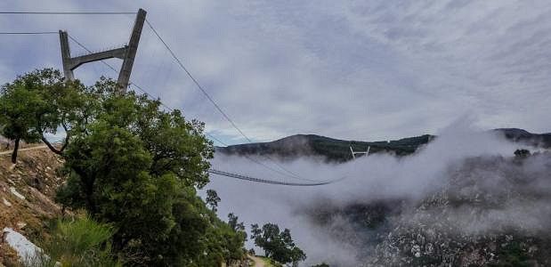
THE WORLD'S LONGEST SUSPENSION BRIDGE IS IN PORTUGAL
The longest pedestrian suspension bridge in the world has opened in Portugal. The 516 meter long structure spans the valley of the river Rio Pavia near the town of Arouca.
The huge structure is 516 meters long and is therefore known as the 516 Arouca . The colossus hangs 175 meters above the river and is therefore not exactly for people with a fear of heights! But if you manage to overcome the height, you will get something in return: a fantastic view of the valley of the Rio Pavia, which is located in the middle of the UNESCO Geopark Arouca.
R. Alfredo Vaz Pinto, 4540-118 Arouca, Portugal
40° 55' 45" N 8° 14' 44.7" W
40.9291537 -8.2457371
• Head north on Rua Dr. Coelho da Rocha. Go for 17 m.
• Turn right onto Rua 1 de Maio. Go for 30 m.
• Turn right onto Rua 1 de Maio. Go for 55 m.
• Turn right onto Avenida 25 de Abril (N326). Go for 295 m.
• Take the 3rd exit from roundabout onto Rua Dom Afonso Henriques (N326). Go for 109 m.
• Continue on Rua Eça de Queiroz. Go for 126 m.
• Take the 2nd exit from roundabout. Go for 144 m.
• Continue on Rua Eça de Queiroz. Go for 13 m.
• Take the 2nd exit from roundabout onto N326. Go for 17.8 km.
• Continue straight ahead. Go for 42 m.
• Continue straight ahead. Go for 21 m.
• Take the 2nd exit from roundabout. Go for 7.1 km.
• Take the 3rd exit from roundabout toward Feira/S. J.ão da Madeira/Arrifana. Go for 1.8 km.
• Keep left toward IC2. Go for 1.4 km.
• Continue on IC2. Go for 13.0 km.
• Take ramp onto N224 toward Estarreja/Lisboa/A1/Porto. Go for 463 m.
• Keep left onto N224 toward Lisboa/A1/Porto/Estarreja. Go for 7.4 km.
• Take the 3rd exit from roundabout onto A1 (Autoestrada do Norte) toward Lisboa. Go for 10.7 km.
• Take exit 16 toward Aveiro onto A25 (Autoestrada da Costa da Prata). Go for 10.7 km.
• Take the exit toward Aveiro onto A25 (Autoestrada Beiras Litoral e Alta). Go for 6.2 km.
• Take exit 3 toward Aveiro. Go for 336 m.
• Take the 1st exit from roundabout. Go for 251 m.
• Take the 2nd exit from Rotunda dos Marnotos roundabout onto Rua Condessa Mumadona Dias. Go for 529 m.
• Take the 3rd exit from roundabout onto Rua dos Santos Mártires. Go for 175 m.
• Continue on Rua Magalhães Serrão. Go for 139 m.
• Continue on Rua da Arrochela. Go for 87 m.
• Turn left onto Rua Homem Cristo Filho. Go for 68 m.
• Turn right onto Travessa das Barcas. Go for 9 m.
• Arrive at Travessa das Barcas. Your destination is on the right.
☍
79,0 km
(1 hrs. 1 min.)
Aveiro, Portugal
Due to the various canals that cross the city, Aveiro is known as the Venice of Portugal. The boats in the canals underline that name even more. The colored houses in the center make it a cheerful place to walk through. Aveiro, Portugal
Tv. das Bargas 4, 3810-164 Aveiro, Portugal
40° 38' 26.1" N 8° 39' 17.8" W
40.6405967 -8.6549534
• Head west on Travessa das Barcas. Go for 9 m.
• Turn left onto Rua Homem Cristo Filho. Go for 48 m.
• Turn right onto Rua José Rabumba. Go for 104 m.
• Turn right onto Rua do Clube dos Galitos. Go for 146 m.
• Take the 4th exit from Praça Humberto Delgado roundabout onto Rua do Clube dos Galitos. Go for 342 m.
• Continue on Rua do Alavário. Go for 237 m.
• Take the 2nd exit from Rotunda dos Marnotos roundabout onto A25 (Autoestrada Beiras Litoral e Alta) toward V. Formoso/Viseu/Lisboa/Porto. Go for 6.1 km.
• Take the left exit toward Viseu/Porto/A29 onto A25 (Autoestrada da Costa da Prata). Go for 147 km.
• Take exit 29 toward Guarda. Go for 1.2 km.
• Take the 2nd exit from roundabout onto Avenida 25 de Abril toward Guarda. Go for 583 m.
• Continue on Rua da Variante. Go for 7 m.
• Continue on Avenida 25 de Abril. Go for 95 m.
• Take the 2nd exit from roundabout onto Avenida 25 de Abril. Go for 686 m.
• Take the 1st exit from roundabout onto Avenida Cidade de Salamanca (N16) toward Centro Guarda. Go for 652 m.
• Take the 1st exit from roundabout onto Rua Cidade de Waterbury (N16) toward Centro. Go for 547 m.
• Turn left toward Avenida Cidade de Bejar/N16. Go for 97 m.
• Continue on Avenida Cidade de Bejar (N16). Go for 366 m.
• Take the 1st exit from roundabout onto Avenida Cidade de Bejar (N16). Go for 176 m.
• Take the 2nd exit from roundabout onto Rua António Sérgio. Go for 678 m.
• Take the 2nd exit from roundabout onto Rua Dom Nuno Álvares Pereira. Go for 86 m.
• Turn right onto Rua Dom Nuno Álvares Pereira toward Centro. Go for 418 m.
• Continue on Largo General Humberto Delgado. Go for 106 m.
• Turn right onto Largo Frei Pedro (N18). Go for 126 m.
• Continue on Rua Alves Roçadas (N18). Go for 20 m.
• Arrive at Rua Alves Roçadas (N18). Your destination is on the left.
☍
159,9 km
(1 hrs. 40 min.)
Parque de Campismo Rossio de Valhelhas
6301, Guarda, Portugal
40° 32' 15.6" N 7° 16' 3.9" W
40.5376800 -7.2677600
• Head toward Rua Marquês de Pombal on Rua Alves Roçadas (N18). Go for 72 m.
• Continue on Largo João de Almeida (N18). Go for 42 m.
• Continue on Rua Doutor Lopo de Carvalho (N18) toward A23/A25. Go for 96 m.
• Continue on Avenida dos Bombeiros Voluntários Egitanienses (N18). Go for 619 m.
• Take the 1st exit from roundabout onto Avenida Monsenhor Mendes do Carmo (N16). Go for 574 m.
• Take the 2nd exit from roundabout onto Avenida Cónego Álvaro Quintalo da Cunha toward Vilar Formoso/A23/Aveiro/A25/Rio Diz. Go for 361 m.
• Turn sharp right onto Variante à Estrada do Rio Diz. Go for 400 m.
• Continue on Avenida Cónego Álvaro Quintalo da Cunha. Go for 106 m.
• Continue on Variante à Estrada do Rio Diz. Go for 835 m.
• Turn left onto Avenida Cardeal José Saraiva Martins. Go for 1.5 km.
• Take the 3rd exit from roundabout onto Avenida 25 de Abril. Go for 174 m.
• Continue on Rua da Variante. Go for 7 m.
• Continue on Avenida 25 de Abril. Go for 543 m.
• Take the 1st exit from roundabout onto A25 (Autoestrada Beiras Litoral e Alta) toward Aveiro/Viseu. Go for 76.6 km.
• Take exit 17 toward Coimbra/Tondela onto IP3. Go for 54.1 km.
• Take ramp toward V. N. Poiares/Penacova. Go for 266 m.
• Turn right onto M534 toward N2/V. N. Poiares/Penacova. Go for 36 m.
• Turn left onto N2. Go for 2.0 km.
• Continue on Estrada Nacional (N2). Go for 95 m.
• Continue on N2. Go for 38 m.
• Continue on Estrada Nacional (N2). Go for 56 m.
• Continue on N2. Go for 28 m.
• Continue on Estrada Nacional (N2). Go for 207 m.
• Continue on N2. Go for 16 m.
• Continue on Estrada Nacional (N2). Go for 80 m.
• Continue on N2. Go for 16 m.
• Continue on Estrada Nacional (N2). Go for 173 m.
• Continue on N2. Go for 678 m.
• Turn right onto N235. Go for 195 m.
• Turn left onto R110. Go for 18.5 km.
• Take the 1st exit from roundabout onto N17 toward Viseu/IP3. Go for 734 m.
• Take the 1st exit from roundabout onto Rua da Escola toward Areeiro. Go for 143 m.
• Take the 1st exit from roundabout. Go for 30 m.
• Turn left. Go for 168 m.
• Turn right. Go for 94 m.
• Turn right. Go for 155 m.
• Arrive at your destination on the right.
☍
159,7 km
(2 hrs. )
Coimbra Camping & Bungalows
COIMBRACoimbra's history dates back to the Middle Ages when it was the capital of Portugal. Coimbra is home to the oldest university in Portugal (and one of the oldest in Europe). Probably thanks to the university there is a relaxed atmosphere. Chill out in the park, visit one of the many cafes or the monuments in the historic center of the city. Highlights are; the university, the library, the cathedral and the monastery. Be sure to walk up through the narrow streets. This way you will automatically reach viewpoints and hidden bars. The park along the river is the place to enjoy the sun.
Rua da Escola, Alto do Areeiro, 3030-011, Coimbra, Portugal
40° 11' 18.3" N 8° 23' 56.7" W
40.1884100 -8.3990900
• Head northwest. Go for 78 m.
• Turn right toward Rua da Escola. Go for 8 m.
• Take the 3rd exit from roundabout onto Rua da Escola. Go for 193 m.
• Take the 3rd exit from roundabout onto N17 toward Penacova/N110/Lousã/Miranda do Corvo/V.N. de Poiares. Go for 785 m.
• Take the 2nd exit from roundabout onto N17 toward Lousã/V. N. Poiares. Go for 802 m.
• Take the 2nd exit from roundabout toward Tomar. Go for 2.0 km.
• Take the 1st exit from roundabout onto A13 (Autoestrada do Pinhal Interior) toward Tomar. Go for 29.8 km.
• Take exit 24 toward C.lo Branco onto IC8. Go for 19.2 km.
• Take ramp toward Pedrógão G.de Norte/Pampilhosa. Go for 325 m.
• Continue on N2. Go for 1.1 km.
• Turn right onto N2. Go for 381 m.
• Turn sharp left. Go for 409 m.
• Turn right toward Rua do Cabril. Go for 474 m.
• Continue on Rua do Cabril. Go for 661 m.
• Turn right onto Rua do Vau. Go for 94 m.
• Turn right. Go for 39 m.
• Arrive at your destination on the left.
☍
56,4 km
( 40 min.)
Parque de Campismo Municipal de Pedrógão Grande
Vale de Góis, 3270 - 159, Pedrogão Grande, Portugal
39° 55' 26" N 8° 7' 59.6" W
39.9238900 -8.1332300
• Head toward Rua do Vau. Go for 39 m.
• Turn right onto Rua do Vau. Go for 1.2 km.
• Turn left onto N2. Go for 526 m.
• Continue on Estrada da Barragem do Cabril (N350). Go for 2.1 km.
• Continue on Rua da Escola (N350). Go for 355 m.
• Turn right onto N350 toward Castelo Branco/Sertã/Painho. Go for 299 m.
• Turn left and take ramp toward C. Branco/Sertã. Go for 104 m.
• Turn right onto IC8. Go for 11.3 km.
• Take ramp toward Centro Sertã/Oleiros. Go for 184 m.
• Turn right onto N238. Go for 571 m.
• Take the 2nd exit from roundabout onto N238 toward Oleiros. Go for 11.2 km.
• Continue on N238 toward Oleiros. Go for 8.9 km.
• Pass 2 roundabouts and continue on N238. Go for 4.0 km.
• Turn right. Go for 352 m.
• Turn slightly left. Go for 148 m.
• Arrive at your destination on the left.
☍
41,3 km
( 34 min.)
Parque de Campismo de Oleiros
Acude Pinto, 6160-301, Oleiros, Portugal
39° 55' 15.3" N 7° 53' 32.4" W
39.9209200 -7.8923400
• Head west. Go for 148 m.
• Turn slightly right toward N238. Go for 352 m.
• Turn right onto N238. Go for 25.4 km.
• Turn right onto N112. Go for 19.9 km.
• Turn left toward Cardoso. Go for 123 m.
• Continue on Cardoso. Go for 363 m.
• Continue toward Rua do Santo. Go for 812 m.
• Continue on Rua do Santo. Go for 463 m.
• Turn right onto Rua Doutor António Afonso Saraiva. Go for 502 m.
• Turn slightly right onto Rua da Fonte Guino. Go for 617 m.
• Turn left. Go for 789 m.
• Arrive at your destination.
☍
49,4 km
( 51 min.)
6000-521 Freixial do Campo, Portugal
Joy Babid - Sleep with the family between olive and fig trees 3 With us, traveling families will find a motorhome pitch between olive and fig trees, in harmony with nature. The freedom of parents and children is central to this. We attach great importance to a natural environment. That is why we cannot offer a waste station. We ask our guests to empty their gray and black water before coming to us. A free option is the Intermarché in the industrial area of Castelo Branco. You can also wash your clothes here. You can then hang your laundry with us. There is a drinking water source 5 minutes from us at the entrance of the village of Salgueiro do Campo on the left. Our little paradise is located near Castelo Branco, Portugal, on the edge of the pretty village of Freixial do Campo.Offers:You can fully enjoy nature on our property. Here you have your little island between olive and fig trees. There are plenty of trails around the property for walking and hiking. Especially the two neighboring villages of Juncal and Freixial do Campo show the natural way of life of the Portuguese with a breathtaking view of the mountains. Near our campsite, 10 minutes away, is a beautiful swimming lake. There is also a natural river bath 8 minutes away, which also invites you to swim. Within the village of Freixial do Campo there are three cafes and in the neighboring village of Juncal do Campo there is a shop where you can also buy organic and vegan products. For larger purchases, Castelo Branco is a good choice, about 20 minutes away. There are all kinds of shopping and cultural opportunities here. from € 11.25
39° 55' 8.5" N 7° 33' 11.9" W
39.9190206 -7.5533148
• Head southwest. Go for 789 m.
• Turn right toward Rua da Fonte Guino. Go for 140 m.
• Turn left onto Rua da Fonte Guino. Go for 477 m.
• Turn left onto M550. Go for 25 m.
• Continue on M550. Go for 1.6 km.
• Keep left onto M550. Go for 1.7 km.
• Turn left onto N112. Go for 8.7 km.
• Take the 3rd exit from roundabout onto N233 toward Espanha/Penamacor/A23. Go for 287 m.
• Take the 1st exit from roundabout onto N233 toward A23. Go for 132 m.
• Take the 1st exit from roundabout onto N3 toward A23. Go for 1.1 km.
• Take left ramp onto A23 (Autoestrada da Beira Interior) toward Portalegre/Lisboa. Go for 122 km.
• Take the exit toward Porto/Fátima onto A1 (Autoestrada do Norte). Go for 35.3 km.
• Take exit 9 toward Leiria/(N242)/M.nha Grande onto A8-1. Go for 2.8 km.
• Keep left onto A8-1 toward Leiria Sul/A8/Aveiro/A17/Batalha/A19. Go for 252 m.
• Take ramp onto A8-1. Go for 469 m.
• Continue on A8 (Autoestrada do Oeste) toward Leiria Sul/Aveiro/A17/Batalha/A19. Go for 11.3 km.
• Take the exit onto A8 (Autoestrada do Oeste). Go for 21.1 km.
• Take exit 22 toward Nazaré. Go for 1.1 km.
• Take the 2nd exit from roundabout onto N8-5 toward Tomar/Nazaré. Go for 663 m.
• Take the 3rd exit from roundabout onto N8-5 toward Nazaré. Go for 228 m.
• Take the 2nd exit from roundabout onto Avenida da Nazaré (N8-5). Go for 1.9 km.
• Continue on N8-5. Go for 1.3 km.
• Arrive at N8-5. Your destination is on the left.
☍
213,6 km
(2 hrs. 10 min.)
Parque Orbitur Valado / Nazaré
R. dos Combatentes do Ultramar 2, EN 8-5 Km 9 , 2450 - 148, Nazaré, Portugal
39° 35' 45" N 9° 2' 59" W
39.5958300 -9.0497200
• Head west on N8-5. Go for 590 m.
• Take the 4th exit from roundabout onto N8-5 toward Valado dos Frades. Go for 2.0 km.
• Continue on Avenida da Nazaré (N8-5). Go for 1.8 km.
• Take the 2nd exit from roundabout onto N8-5. Go for 237 m.
• Take the 2nd exit from roundabout onto N8-5 toward Alcobaça/A8. Go for 664 m.
• Take the 3rd exit from roundabout onto A8 (Autoestrada do Oeste) toward Leiria. Go for 20.6 km.
• Take the exit toward Leiria Sul/A1/N242/M.nha Grande onto A8 (Nó da A8-A17). Go for 12.6 km.
• Take exit 29 toward Lisboa/Porto/A1 onto A8-1. Go for 2.5 km.
• Take ramp onto A1 (Autoestrada do Norte) toward Lisboa/Fátima. Go for 35.7 km.
• Take exit 7 toward Abrantes/T.res Novas/Alcanena onto A23 (Autoestrada da Beira Interior). Go for 25.5 km.
• Take the exit toward Constância Oeste. Go for 409 m.
• Continue on N358-1. Go for 1.1 km.
• Continue toward N3. Go for 25 m.
• Turn left onto N3. Go for 239 m.
• Turn right onto N3. Go for 11 m.
• Turn right onto Avenida das Forças Armadas. Go for 237 m.
• Arrive at Avenida das Forças Armadas. Your destination is on the left.
☍
104,3 km
(1 hrs. 1 min.)
Parque de Campismo Rural de Constância
Avenida das Forças Armadas, 2250 - 020, Constância, Portugal
39° 28' 32.2" N 8° 20' 26.3" W
39.4756100 -8.3406400
• Head southeast on Avenida das Forças Armadas. Go for 4 m.
• Turn left onto Rua Santa Ana e Ouro. Go for 97 m.
• Turn right onto Avenida das Forças Armadas. Go for 176 m.
• Turn left onto N3. Go for 11 m.
• Turn left onto N3. Go for 202 m.
• Turn right onto N358-1. Go for 1.2 km.
• Take ramp onto A23 (Autoestrada da Beira Interior) toward Entronc.to. Go for 25.5 km.
• Take the left exit toward Lisboa/Santarém onto A1 (Autoestrada do Norte). Go for 26.7 km.
• Take exit 6A toward C.das Rainha/Rio Maior onto A15 (Nó da A1-A15). Go for 40.8 km.
• Take the exit onto A8 (Autoestrada do Oeste). Go for 1.6 km.
• Take exit 15 toward Óbidos/Peniche. Go for 669 m.
• Take the 2nd exit from roundabout onto N8 toward Peniche. Go for 737 m.
• Take the 3rd exit from roundabout onto Estrada da Capeleira. Go for 170 m.
• Turn right. Go for 16 m.
• Arrive at your destination on the left.
☍
97,9 km
( 56 min.)
Parque De Autocaravanas
R. dos Arcos, 2510-086, Óbidos, Portugal
39° 21' 23" N 9° 9' 24" W
39.3563889 -9.1566667
• Head toward Estrada da Capeleira. Go for 16 m.
• Turn left onto Estrada da Capeleira. Go for 131 m.
• Take the 1st exit from roundabout onto N8. Go for 655 m.
• Take the 1st exit from roundabout onto A8 (Autoestrada do Oeste) toward Lisboa. Go for 65.4 km.
• Take exit 3A toward A5/IC19/A16/IC22 onto A9 (CREL). Go for 13.2 km.
• Take exit 2A toward Cascais/Sintra/Agualva/Cacém onto A16. Go for 11.9 km.
• Take exit 8 toward Centro Sintra/Colares onto Avenida General Mário Firmino Miguel. Go for 1.0 km.
• Take the 2nd exit from Rotunda Doutor Eduardo Lacerda Tavares roundabout onto Avenida Doutor Desidério Cambournac toward Colares/Lourel/Estefânea Norte/Portela. Go for 555 m.
• Take the 2nd exit from roundabout onto Avenida Doutor Desidério Cambournac toward Colares/Estefânea-Norte. Go for 353 m.
• Arrive at Avenida Doutor Desidério Cambournac. Your destination is on the left.
☍
93,2 km
( 54 min.)
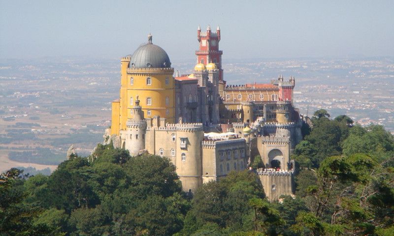
Sintra, Portugal
Near the village of Sintra in Portugal, there is a palace that can be seen as the pinnacle of Romantic architecture. Surrounded by a park, the Palácio Nacional da Pena consists of so many different turrets and colors that it almost looks like a fairytale castle.
The palace Palácio Nacional da Pena is beautifully situated on top of one of the hills near the Portuguese village of Sintra. Looking over the battlements, you can see the once beautiful Moorish castle in the distance, which has sadly fallen into ruins. Initially, the location of the Palácio was not a palace, but a 16th-century monastery dedicated to Saint Jerome. This monastery never housed more than 18 monks and it was a true haven of peace and tranquility until the 18th century.
Av. Dr. Desidério Cambournac 2, 2710-573 Sintra, Portugal
38° 48' 8.8" N 9° 22' 53.8" W
38.8024443 -9.3816008
• Head toward Rua Cp. Mário Alberto Soares Pimentel on Avenida Doutor Desidério Cambournac. Go for 11 m.
• Continue on Avenida Heliodoro Salgado (N9). Go for 115 m.
• Take the 4th exit from roundabout onto Avenida Heliodoro Salgado (N9). Go for 206 m.
• Continue on Avenida Doutor Desidério Cambournac. Go for 311 m.
• Take the 2nd exit from roundabout onto Avenida Doutor Desidério Cambournac. Go for 565 m.
• Take the 1st exit from Rotunda Doutor Eduardo Lacerda Tavares roundabout onto Avenida General Mário Firmino Miguel toward A16/A9/IC19/Algueirão. Go for 578 m.
• Take ramp onto A16 toward Lisboa/IC19/Cascais. Go for 10.7 km.
• Take the exit toward Lisboa/Cascais/Cascais Oeste onto A5 (Autoestrada da Costa do Estoril). Go for 2.5 km.
• Take ramp onto Estrada da Malveira da Serra (N9-1). Go for 574 m.
• Take the 2nd exit from roundabout onto Estrada da Malveira da Serra (N9-1). Go for 362 m.
• Take the 1st exit from roundabout onto Rua de Birre (M593). Go for 521 m.
• Take the 2nd exit from Rotunda Carlos Zel roundabout onto Rua de Birre (M597). Go for 541 m.
• Continue on Rua da Areia (M597). Go for 925 m.
• Take the 2nd exit from Praça Henrique Champalimaud roundabout onto Rua Ivone Silva (N247-6). Go for 619 m.
• Take the 3rd exit from Rotunda Dom Carlos I roundabout onto Rua da Areia (N247-6). Go for 1.1 km.
• Turn left onto Estrada do Guincho (N247). Go for 3.0 km.
• Turn right. Go for 71 m.
• Arrive at your destination on the right.
☍
22,7 km
( 23 min.)
Cabo de roca, Portugal
CABO DA ROCAThe views and sunset are amazing from the westernmost point of continental Europe (and Portugal). Although it is an attraction, with buses coming and going, there are some nice spots to enjoy the scenery. The hiking trail on the other side of the lighthouse offers some great views of the cliffs. Get to Cabo da Roca early to have it to yourself. The first bus arrives around 8:30 AM and the last one leaves around 10 PM.Cabo da Roca, Estrada do
Portugal
38° 42' 34.2" N 9° 29' 11.5" W
38.7095024 -9.4865172
• Head east. Go for 71 m.
• Turn left onto Estrada do Guincho (N247). Go for 2.9 km.
• Turn right onto Rua da Areia (N247-6). Go for 1.1 km.
• Take the 2nd exit from Rotunda Dom Carlos I roundabout onto Rua Ivone Silva (N247-6). Go for 608 m.
• Take the 2nd exit from Praça Henrique Champalimaud roundabout onto Rua da Areia (M597). Go for 972 m.
• Continue on Rua de Birre (M597). Go for 510 m.
• Take the 2nd exit from Rotunda Carlos Zel roundabout onto Rua de Birre (M593). Go for 545 m.
• Take the 3rd exit from roundabout onto Estrada da Malveira da Serra (N9-1). Go for 366 m.
• Take the 2nd exit from roundabout onto Estrada da Malveira da Serra (N9-1). Go for 270 m.
• Take ramp onto A5 (Autoestrada da Costa do Estoril) toward Lisboa/Estoril/A16/Sintra/A9. Go for 16.4 km.
• Take exit 6 toward Loures/A1/A8/A10 onto A9 (CREL). Go for 19.6 km.
• Take exit 5 toward Leiria onto A8 (Autoestrada do Oeste). Go for 18.7 km.
• Take exit 6 toward Sobral de M.te Agraço/Enxara Pero Negro. Go for 505 m.
• Turn left onto N9-2. Go for 728 m.
• Continue on Variante N9-2. Go for 995 m.
• Take the 2nd exit from roundabout onto N374. Go for 712 m.
• Continue on Rua do Casal Madorno (N374). Go for 182 m.
• Continue on N374. Go for 77 m.
• Continue on Rua Casal Modorno (N374). Go for 101 m.
• Continue on N374. Go for 32 m.
• Continue on Rua Casal Modorno (N374). Go for 139 m.
• Continue on N374. Go for 398 m.
• Continue on Rua Principal (N374). Go for 649 m.
• Continue on N374. Go for 1.8 km.
• Continue on Rua A do Mato (N374). Go for 137 m.
• Continue on N248. Go for 882 m.
• Continue on Avenida 25 de Abril (N248). Go for 400 m.
• Continue on Largo do Sizandro (N248). Go for 9 m.
• Turn left onto Rua Valério da Costa. Go for 86 m.
• Turn right onto Rua Valério da Costa. Go for 85 m.
• Turn right onto Rua General França Borges. Go for 2.0 km.
• Turn right. Go for 610 m.
• Arrive at your destination.
☍
72,5 km
( 59 min.)
2RJ4+X5 Dois Portos, Portugal
39° 1' 56.9" N 9° 11' 40.6" W
39.0324831 -9.1946099
• Head southwest. Go for 732 m.
• Turn slightly right onto Rua 17 de Dezembro. Go for 302 m.
• Turn right onto M1092. Go for 1.1 km.
• Continue on Rua do Castelo (M1092). Go for 243 m.
• Turn right onto Estrada Principal (N248). Go for 2.0 km.
• Turn right onto N248. Go for 1.5 km.
• Continue on Avenida 25 de Abril (N248). Go for 173 m.
• Continue on Largo do Sizandro (N248). Go for 9 m.
• Continue on Avenida 25 de Abril (N248). Go for 400 m.
• Continue on N248. Go for 882 m.
• Continue on Rua A do Mato (N248). Go for 137 m.
• Continue on N374. Go for 1.8 km.
• Continue on Rua Principal (N374). Go for 649 m.
• Continue on N374. Go for 398 m.
• Continue on Rua Casal Modorno (N374). Go for 139 m.
• Continue on N374. Go for 32 m.
• Continue on Rua Casal Modorno (N374). Go for 101 m.
• Continue on N374. Go for 77 m.
• Continue on Rua do Casal Madorno (N374). Go for 182 m.
• Continue on N374. Go for 626 m.
• Take the 1st exit from roundabout onto Variante N9-2. Go for 1.0 km.
• Continue on N9-2. Go for 680 m.
• Take ramp onto A8 (Autoestrada do Oeste) toward Lisboa. Go for 26.4 km.
• Take ramp onto CRIL (A36) toward Odivelas/A9/CREL. Go for 7.8 km.
• Keep left onto CRIL (A36) toward Algés/Cascais/A5/Alfragide. Go for 5.2 km.
• Keep left onto CRIL (A36) toward Centro Lisboa/Belém. Go for 750 m.
• Take the 1st exit from roundabout onto Avenida de Brasília toward Centro Lisboa/Belém. Go for 308 m.
• Continue on Avenida Doutor Alfredo Magalhães Ramalho. Go for 109 m.
• Continue on Avenida de Brasília. Go for 1.1 km.
• Turn right onto Doca do Bom Sucesso. Go for 17 m.
• Turn right onto Doca do Bom Sucesso. Go for 168 m.
• Arrive at Doca do Bom Sucesso.
☍
55,0 km
( 46 min.)
Lisboa, Portugal
Modelo 3D da Torre de Belém em Lisboa, Av. Brasília, 1400-038 Lisboa, Portugal
38° 41' 29.7" N 9° 12' 57.2" W
38.6915951 -9.2158987
• Head south on Doca do Bom Sucesso.
• Turn left onto Doca do Bom Sucesso. Go for 57 m.
• Turn left onto Doca do Bom Sucesso. Go for 176 m.
• Turn left onto Avenida de Brasília. Go for 481 m.
• Turn right toward Avenida da Índia. Go for 404 m.
• Continue on Avenida da Índia. Go for 430 m.
• Turn right onto Praça de Dom Manuel I. Go for 143 m.
• Take ramp onto CRIL (A36) toward Norte/A1/Lisboa/A5/Aeroporto/2a Circular. Go for 3.3 km.
• Take ramp toward Buraca. Go for 248 m.
• Arrive at your destination on the right.
☍
5,2 km
( 6 min.)
Lisboa Camping & Bungalows
Estrada da Circunvalação, 1400 - 061, Monsanto, Portugal
38° 43' 28.4" N 9° 12' 28.8" W
38.7245600 -9.2080000
• Take ramp. Go for 10 m.
• Continue on Estrada da Circunvalação. Go for 227 m.
• Turn left onto Estrada de Almarjão. Go for 84 m.
• Take the 1st exit from roundabout onto Estrada de Almarjão. Go for 440 m.
• Take the 1st exit from roundabout onto CRIL (A36) toward Algés/Cascais/A5/Sul/A2. Go for 662 m.
• Take ramp onto N117 toward A5/Lisboa/A2/Sul/Belém. Go for 1.0 km.
• Take ramp onto A5 (Autoestrada da Costa do Estoril) toward Lisboa/Sul/A2. Go for 2.5 km.
• Keep right toward Pr. de Espanha/Sul/A2. Go for 734 m.
• Take the exit toward A2/Sul/Ponte onto IP7 (Eixo Norte-Sul). Go for 4.8 km.
• Continue on A2 (Autoestrada do Sul). Go for 10.3 km.
• Take exit 2 toward Sesimbra/(N10)/Azeitão onto N378 (Avenida 23 de Julho de 1833). Go for 1.3 km.
• Pass 4 roundabouts and continue on N377. Go for 16.4 km.
• Take the 1st exit from roundabout onto Rua da Marconi. Go for 1.5 km.
• Turn left onto Rua Praia Moinho de Baixo (M561-1). Go for 666 m.
• Continue on Rua dos Curvais (M561-1). Go for 338 m.
• Turn right onto Rua da Fonte. Go for 859 m.
• Turn slightly right onto Rua dos Campos. Go for 220 m.
• Turn left toward Rua da Roma. Go for 226 m.
• Turn right onto Rua da Roma. Go for 211 m.
• Turn slightly right onto Rua 25 de Abril. Go for 842 m.
• Turn slightly right onto Rua das Bicas. Go for 443 m.
• Turn left onto Rua das Bicas. Go for 167 m.
• Turn right. Go for 89 m.
• Arrive at your destination on the left.
☍
44,1 km
( 47 min.)
Parque de Campismo Campimeco
Praia das Bicas, Aldeia do Meco, 2970 - 001, Sesimbra, Portugal
38° 27' 49.3" N 9° 11' 21.1" W
38.4637000 -9.1892000
• Head toward Rua das Bicas. Go for 89 m.
• Turn left onto Rua das Bicas. Go for 610 m.
• Turn slightly left onto Rua 25 de Abril. Go for 842 m.
• Turn slightly left onto Rua da Roma. Go for 1.0 km.
• Turn slightly left onto Rua da Escola. Go for 185 m.
• Continue on Rua Praia Moinho de Baixo. Go for 107 m.
• Turn left onto Rua dos Curvais. Go for 754 m.
• Continue on Rua Praia Moinho de Baixo (M561-1). Go for 666 m.
• Turn right toward Rua da Marconi. Go for 228 m.
• Continue on Rua da Marconi. Go for 1.2 km.
• Take the 3rd exit from roundabout onto N377. Go for 10.8 km.
• Take the 3rd exit from roundabout. Go for 160 m.
• Continue on Avenida 23 de Julho de 1833 (N378). Go for 4.3 km.
• Pass 3 roundabouts and continue on Avenida 23 de Julho de 1833 (N378). Go for 1.7 km.
• Take ramp onto A2 (Autoestrada do Sul) toward Setúbal. Go for 66.7 km.
• Take exit 8 toward Alcácer do Sal onto IC1. Go for 1.8 km.
• Take ramp toward Alcácer/Torrão. Go for 421 m.
• Continue on Avenida José Saramago (N5). Go for 2.5 km.
• Pass 2 roundabouts and continue on Avenida José Saramago (N5). Go for 1.3 km.
• Take the 3rd exit from Largo de 25 Abril roundabout onto Avenida dos Aviadores (N5) toward Montemor/Évora. Go for 1.8 km.
• Turn right onto Rua Abel Severino Felicíssimo (N5). Go for 30.2 km.
• Continue on N5-2. Go for 1.1 km.
• Continue on N2. Go for 16.5 km.
• Turn left onto N257. Go for 3.1 km.
• Turn right. Go for 2.5 km.
• Turn left. Go for 580 m.
• Arrive at your destination on the left.
☍
151,2 km
(2 hrs. 2 min.)
Camping Markádia
Barragem de Odivelas, 7920 - 999, Alvito, Portugal
38° 11' 2.4" N 8° 6' 11.9" W
38.1840000 -8.1033000
• Head toward Herdade Markadia Rebolado Lda. Go for 580 m.
• Turn right toward N257. Go for 2.5 km.
• Turn right onto N257. Go for 15.2 km.
• Continue on Adro. Go for 95 m.
• Continue on Largo da Igreja. Go for 38 m.
• Continue on Rua das Igrejas. Go for 26 m.
• Continue on Avenida dos Bombeiros Voluntários (N257). Go for 9.0 km.
• Turn right toward Estrada de Portel/N384. Go for 315 m.
• Take the 1st exit from roundabout onto Estrada de Portel (N384). Go for 16.2 km.
• Turn right onto M531. Go for 2.9 km.
• Turn right toward Monte Alfaiates. Go for 697 m.
• Continue on Monte Alfaiates. Go for 993 m.
• Turn left. Go for 617 m.
• Turn right. Go for 1.7 km.
• Turn right. Go for 1.4 km.
• Arrive at your destination.
☍
52,3 km
(1 hrs. 2 min.)
Viana do Alentejo, Portugal
nice spot found via park4nicht.on a lake at Igrejinha (Portugal) near Evora.
74R5+RR6 Viana do Alentejo, Portugal
38° 17' 31.3" N 7° 53' 25.7" W
38.2920416 -7.8904787
• Head east. Go for 1.4 km.
• Turn left. Go for 1.7 km.
• Turn left. Go for 617 m.
• Turn right toward Monte Alfaiates. Go for 848 m.
• Continue on Monte Alfaiates. Go for 842 m.
• Turn right onto M531. Go for 3.7 km.
• Continue on Estrada da Oriola (M531). Go for 501 m.
• Turn left onto Rua da Calçada (M531). Go for 22 m.
• Continue on M531. Go for 2.2 km.
• Turn right onto M531. Go for 158 m.
• Turn left onto M531. Go for 30 m.
• Turn right and take ramp onto IP2. Go for 23.5 km.
• Pass 2 roundabouts and continue on IP2. Go for 4.4 km.
• Take the 2nd exit from roundabout onto IP2 toward C. Verde/Ourique/Beja. Go for 1.9 km.
• Take the 1st exit from roundabout onto N18 toward Aljustrel. Go for 20.1 km.
• Turn left onto N2. Go for 12.5 km.
• Keep right toward M539. Go for 85 m.
• Continue on M539. Go for 1.2 km.
• Turn right onto Praça da República (N261). Go for 1.1 km.
• Take the 2nd exit from roundabout onto N263. Go for 28.8 km.
• Take the 1st exit from roundabout onto N389 toward Cercal/Sines/N120-1. Go for 1.7 km.
• Arrive at N389. Your destination is on the right.
☍
107,5 km
(1 hrs. 41 min.)
PHMF+CM Colos, Portugal
37° 44' 1" N 8° 25' 33" W
37.7336205 -8.4258440
• Head southeast on N389. Go for 1.7 km.
• Take the 1st exit from roundabout onto N263 toward Odemira/Oeste. Go for 3.3 km.
• Turn left onto N123-1. Go for 8.1 km.
• Continue on Largo do Poço Novo (N123-1). Go for 36 m.
• Continue on N123-1. Go for 64 m.
• Turn right onto N123. Go for 12.4 km.
• Turn left onto N266. Go for 22.3 km.
• Take the 2nd exit from roundabout onto N266. Go for 13.7 km.
• Continue on Altura das Corchas (N266). Go for 173 m.
• Continue on N266. Go for 5.2 km.
• Take the 2nd exit from roundabout onto Estrada de Saboia (N266). Go for 302 m.
• Turn left onto Rua Dom Francisco Gomes de Avelar (N266). Go for 215 m.
• Continue on Largo dos Chorões. Go for 26 m.
• Turn left onto Largo dos Chorões. Go for 20 m.
• Turn left onto Rua Eng. Duarte Pacheco. Go for 191 m.
• Take the 4th exit from roundabout onto Estrada Velha toward Lisboa/IC1/Portimão/N266/Aljezur/N267. Go for 455 m.
• Turn right onto Rua Serpa Pinto (N266). Go for 21 m.
• Continue on Largo de Santo Pé da Cruz (N266). Go for 18 m.
• Take the 2nd exit from roundabout onto Largo de Santa Pé da Cruz (N266) toward Portimão. Go for 1.9 km.
• Turn right onto N267. Go for 3.8 km.
• Arrive at N267. Your destination is on the left.
☍
73,9 km
(1 hrs. 12 min.)
7CR3+42 Monchique, Portugal
37° 17' 25.1" N 8° 35' 51" W
37.2902972 -8.5974888
• Head south on N267. Go for 25.1 km.
• Enter the roundabout. Go for 46 m.
• Arrive at your destination on the left.
☍
25,2 km
( 22 min.)
Aljezur, Portugal
8670 Aljezur, Portugal
37° 18' 59.7" N 8° 47' 57.4" W
37.3165700 -8.7992645
• Follow the roundabout. Go for 73 m.
• Take the 3rd exit from roundabout onto Avenida General Humberto Delgado (N120) toward Lagos/Bordeira. Go for 7.5 km.
• Turn right onto N268 toward V. do Bispo/Sagres/Alfambras/Bordeira/Carrapateira. Go for 27.7 km.
• Take the 4th exit from roundabout toward Sagres. Go for 125 m.
• Turn right onto N268. Go for 7.4 km.
• Continue on Avenida Infante Dom Henrique (N268). Go for 1.4 km.
• Take the 1st exit from roundabout onto Estrada ao Cabo de São Vicente (N268). Go for 1.1 km.
• Continue on N268. Go for 1.6 km.
• Turn left onto N268. Go for 3.0 km.
• Arrive at N268. Your destination is on the left.
☍
49,8 km
( 48 min.)
Cabo de São Vicente, Sagres, Portugal
Kaap Sint-Vincent, 8650 Sagres, Portugal
37° 1' 24" N 8° 59' 40" W
37.0233333 -8.9944444
• Head northeast on N268. Go for 3.0 km.
• Turn right onto N268. Go for 1.6 km.
• Continue on Estrada ao Cabo de São Vicente (N268). Go for 1.1 km.
• Take the 3rd exit from roundabout onto Avenida Infante Dom Henrique (N268). Go for 1.1 km.
• Arrive at Avenida Infante Dom Henrique (N268). Your destination is on the left.
☍
6,8 km
( 12 min.)
Sagres, Portugal
8650 Sagres, Portugal
37° 1' 0.6" N 8° 56' 26.1" W
37.0168293 -8.9405931
• Head toward Rua da Bica on Avenida Infante Dom Henrique (N268). Go for 333 m.
• Continue on N268. Go for 7.3 km.
• Continue on N125. Go for 3.5 km.
• Pass 6 roundabouts and continue on N125. Go for 10.9 km.
• Take the 3rd exit from roundabout onto N125. Go for 1.9 km.
• Pass 2 roundabouts and continue on N125. Go for 4.0 km.
• Take the 3rd exit from roundabout toward Lagos/A22/Portimão. Go for 145 m.
• Continue straight ahead. Go for 836 m.
• Take the 3rd exit from roundabout toward Faro/Portimão. Go for 4.4 km.
• Take ramp onto A22 (Via Infante de Sagres) toward Faro/Lisboa/(A2). Go for 44.6 km.
• Take exit 9 toward (N395)/Albufeira/(N125)/Guia onto IC1. Go for 926 m.
• Take left ramp onto N125 toward (N395)/Albufeira/Ferreiras. Go for 1.4 km.
• Take ramp toward Albufeira/Ferreiras. Go for 268 m.
• Take the 1st exit from roundabout onto N395 toward Albufeira. Go for 2.0 km.
• Pass 2 roundabouts and continue on N395. Go for 1.0 km.
• Take the 1st exit from roundabout onto Avenida dos Descobrimentos (M526) toward Galé. Go for 572 m.
• Turn left onto Avenida Ténis. Go for 201 m.
• Take the 1st exit from roundabout onto Avenida do Ténis. Go for 311 m.
• Continue on Rua Coronel Águas. Go for 209 m.
• Turn sharp left onto Rua do Pôr do Sol. Go for 64 m.
• Turn right onto Rua Latino Coelho. Go for 98 m.
• Turn left onto Largo Rossio. Go for 19 m.
• Turn right onto Rua Latino Coelho. Go for 121 m.
• Arrive at Rua Latino Coelho. Your destination is on the right.
☍
85,2 km
( 59 min.)
Albufeira, Portugal
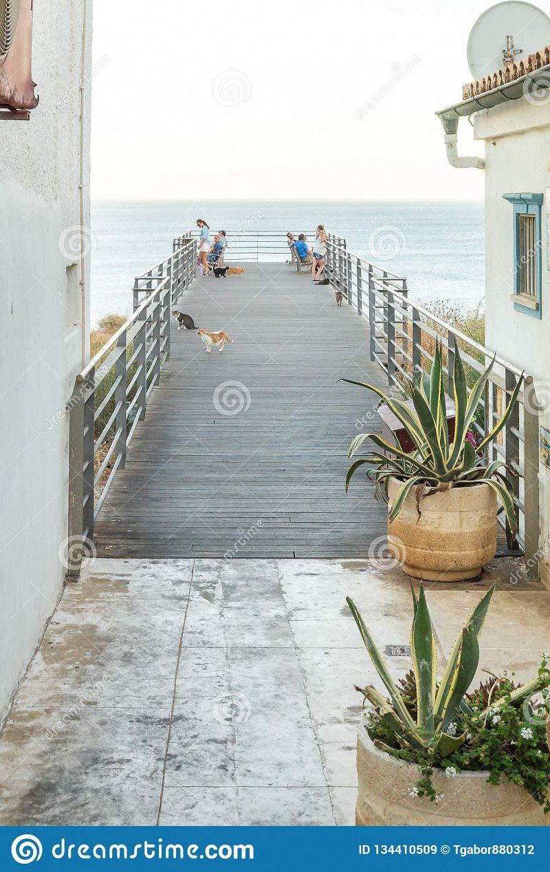
cat park
It's fantastic how the cats have their own place here. At first it seemed that there was not a single cat until we brought out the food. Before we knew it we were surrounded by sweet cuddly cats. Loved it!The Cat Park viewpoint, in Albufeira beach, Algarve, Portugal
R. Latino Coelho 29, 8200-123 Albufeira, Portugal
37° 5' 6.4" N 8° 15' 21.5" W
37.0851068 -8.2559742
• Head toward Esplanada Doutor Frutuoso da Silva on Rua Latino Coelho. Go for 6 m.
• Turn left onto Travessa Coronel Águas. Go for 115 m.
• Turn right onto Rua Coronel Águas. Go for 196 m.
• Continue on Largo Jacinto d'Ayete. Go for 139 m.
• Continue on Rua 1 de Dezembro. Go for 164 m.
• Take the 1st exit from roundabout onto Avenida Ténis. Go for 192 m.
• Turn right onto Avenida dos Descobrimentos (M526) toward Lisboa/Faro/A22. Go for 571 m.
• Take the 3rd exit from roundabout onto N395 toward Ferreiras/Paderne/Lisboa/A2/Portimão/A22/Faro. Go for 690 m.
• Pass 2 roundabouts and continue on N395. Go for 2.4 km.
• Take the 3rd exit from roundabout onto N395 toward Faro/A22/Portimão/Lisboa/Ferreiras. Go for 245 m.
• Pass 2 roundabouts and continue on Rua das Escolas (N395). Go for 7.5 km.
• Continue on N270. Go for 615 m.
• Continue on Rua 5 de Outubro (N270). Go for 583 m.
• Continue on Rua da Bela Vista (N270). Go for 542 m.
• Turn left onto M1176. Go for 1.7 km.
• Turn left toward Montinho. Go for 97 m.
• Continue on Montinho. Go for 100 m.
• Turn right. Go for 73 m.
• Arrive at your destination on the left.
☍
16,0 km
( 21 min.)
Donkey Tours, Portugal
A fantastic donkey tour covering the Algarve. Idyllic places, rough paths, sweet donkeys and a great host with the most beautiful legends. After the tour we had a delicious Portuguese lunch and swam in the natural pool. Had great conversations with the sweetest owners of Donkey Tours. A real Portuguese experience!
Paderne, 8200, Portugal
37° 10' 46.7" N 8° 10' 24.2" W
37.1796327 -8.1733963
• Head east. Go for 258 m.
• Turn left onto M1176. Go for 295 m.
• Continue on Estrada do Moinho Novo. Go for 3.9 km.
• Turn right toward M1181. Go for 27 m.
• Turn right onto M1181. Go for 471 m.
• Continue on Carvalhas (M1181). Go for 11 m.
• Continue on M1181. Go for 1.2 km.
• Continue on Caminho Municipal 1181 (M1181). Go for 16 m.
• Continue on M1181. Go for 686 m.
• Continue on Rua Jorge Manuel Dias Coelho (M1181). Go for 651 m.
• Turn left onto Avenida Prof. Dr. Aníbal Ant. Cavaco Silva. Go for 299 m.
• Take the 4th exit from roundabout onto Avenida Ayrton Senna da Silva (N270). Go for 2.8 km.
• Continue toward Via Infante de Sagres/A22. Go for 50 m.
• Take ramp onto A22 (Via Infante de Sagres) toward Espanha/Faro. Go for 63.3 km.
• Take exit 17 toward Monte Gordo/(N125). Go for 2.1 km.
• Continue toward N125. Go for 42 m.
• Take the 3rd exit from roundabout onto N125. Go for 386 m.
• Continue on Barranco (N125). Go for 139 m.
• Continue on N125. Go for 1.4 km.
• Take the 2nd exit from roundabout onto N125. Go for 1.9 km.
• Take the 1st exit from roundabout onto N125-7. Go for 523 m.
• Take the 2nd exit from roundabout onto Avenida da Catalunha. Go for 505 m.
• Turn right onto Rua de Kinitra. Go for 153 m.
• Turn left onto Rua de Ceuta. Go for 103 m.
• Continue on Rua de Marzagão. Go for 254 m.
• Take the 2nd exit from roundabout onto Avenida Infante Dom Henrique. Go for 104 m.
• Continue on Estrada da Mata (M511). Go for 346 m.
• Arrive at Estrada da Mata (M511). Your destination is on the right.
☍
81,7 km
( 56 min.)
Parque de Campismo Municipal de Monte Gordo
Estrada Municipal 511, 8900, V. Real de St. Antonio, Portugal
37° 10' 49" N 7° 26' 23" W
37.1802700 -7.4397200
• Head east on Estrada da Mata (M511). Go for 1.7 km.
• Take the 2nd exit from roundabout onto Rua das Comunidades Portuguesas. Go for 357 m.
• Pass 2 roundabouts and continue on Rua das Comunidades Portuguesas. Go for 522 m.
• Take the 3rd exit from roundabout onto N122. Go for 355 m.
• Pass 2 roundabouts and continue on N122. Go for 3.6 km.
• Take the 1st exit from roundabout onto N122. Go for 1.0 km.
• Take ramp onto A22 (Via Infante de Sagres) toward Espanha. Go for 3.0 km.
• Continue on A-49 (Autopista del V Centenario). Go for 132 km.
• Take left exit 0B toward Coria del Río/E-5/Cádiz/A-4/Granada/A-92 onto A-66. Go for 7.8 km.
• Take exit 9A toward Cádiz onto A-4 (Autovía del Sur). Go for 13.3 km.
• Continue on AP-4 (Autopista del Sur). Go for 71.5 km.
• Take exit 84 toward A-381/Algeciras onto A-2004. Go for 725 m.
• Take the 3rd exit from roundabout onto A-2004 toward A-381/Medina Sidonia/Los Barrios/Algeciras/AP-4/Cádiz/Sevilla. Go for 372 m.
• Keep left onto A-381 toward Medina Sidonia/Algeciras. Go for 44.8 km.
• Take exit 45 toward Alcalá de los Gazules. Go for 341 m.
• Take the 3rd exit from roundabout onto C-440a toward Jerez de la Fra./A-381/Alcalá de los Gazules. Go for 256 m.
• Take the 1st exit from roundabout onto Calle Palmosa D. Go for 208 m.
• Continue toward Venta Los Gallos. Go for 1.7 km.
• Continue on Venta Los Gallos. Go for 872 m.
• Turn left. Go for 978 m.
• Continue straight ahead. Go for 1.6 km.
• Turn right. Go for 491 m.
• Arrive at your destination.
☍
287,5 km
(2 hrs. 48 min.)
Camping los Gazules
Ctra. Patrite k 4, 11180, Alcalá de los Gazules, Spain
36° 26' 44.7" N 5° 41' 33.7" W
36.4457500 -5.6926900
• Head northwest. Go for 491 m.
• Turn left. Go for 1.7 km.
• Turn slightly left. Go for 885 m.
• Turn right. Go for 521 m.
• Continue toward Venta Los Gallos. Go for 240 m.
• Continue on Venta Los Gallos. Go for 1.9 km.
• Take the 3rd exit from roundabout onto C-440a toward Algeciras. Go for 238 m.
• Take the 2nd exit from roundabout onto A-381 toward Algeciras. Go for 43.0 km.
• Take the left exit toward San Roque/Estepona/Málaga onto A-7 (Autovía del Mediterráneo). Go for 23.2 km.
• Continue on AP-7 (Autopista del Mediterráneo) toward Estepona/Málaga. Go for 9.7 km.
• Keep right onto AP-7. Go for 12.0 km.
• Continue on A-7 (Autopista del Mediterráneo). Go for 2.8 km.
• Continue on AP-7 (Autopista del Mediterráneo) toward Marbella/Málaga. Go for 15.1 km.
• Keep right toward Autopista del Mediterráneo/AP-7. Go for 321 m.
• Continue on AP-7 (Autopista del Mediterráneo). Go for 8.9 km.
• Continue on A-7 (Autovía del Mediterráneo). Go for 5.2 km.
• Keep left onto AP-7 (Autopista del Mediterráneo) toward Fuengirola/Málaga. Go for 14.7 km.
• Keep right toward Autopista del Mediterráneo/AP-7. Go for 375 m.
• Continue on AP-7 (Autopista del Mediterráneo). Go for 12.0 km.
• Continue on A-7 (Autopista del Mediterráneo). Go for 13.1 km.
• Keep right onto AP-7 toward Torremolinos/Málaga (Oeste)/MA-20/MA-21/Aeropuerto. Go for 3.7 km.
• Continue on MA-20. Go for 12.9 km.
• Continue on A-7 (Autovía del Mediterráneo). Go for 47.6 km.
• Take exit 940 toward Torrox/N-340a/Cómpeta/A-7207. Go for 608 m.
• Take the 1st exit from roundabout onto A-7207 toward Torrox Costa/N-340a. Go for 1.2 km.
• Take the 3rd exit from roundabout onto Calle Rabitilla. Go for 172 m.
• Turn right toward Urbanización Torrox Park Tablazo Norte. Go for 346 m.
• Take the 1st exit from roundabout onto Urbanización Torrox Park Tablazo Norte. Go for 178 m.
• Turn right onto Avenida Miguel de Cervantes. Go for 373 m.
• Arrive at Avenida Miguel de Cervantes. Your destination is on the right.
☍
233,4 km
(2 hrs. 23 min.)
Camping el Pino
Avenida Miguel de Cervantes, nº22. Urbanización Torrox Park, 29793, Torrox Costa, Spain
36° 44' 20.2" N 3° 56' 58.8" W
36.7389500 -3.9496700
• Head southeast on Avenida Miguel de Cervantes. Go for 7 m.
• Turn left onto Urbanización Colinas. Go for 92 m.
• Turn right onto Urbanización Colinas. Go for 234 m.
• Turn left onto Camino de la Loma. Go for 219 m.
• Continue on Urbanización Colinas. Go for 92 m.
• Turn right onto Avenida Miguel de Cervantes. Go for 380 m.
• Turn left onto Urbanización Torrox Park Tablazo Norte. Go for 161 m.
• Take the 3rd exit from roundabout. Go for 399 m.
• Turn left onto Calle Rabitilla. Go for 43 m.
• Take the 1st exit from roundabout onto A-7207 toward Almería/E-15/Málaga/A-7/Torrox/Cómpeta. Go for 1.3 km.
• Take the 3rd exit from roundabout onto A-7207 toward Torrox/Cómpeta/E-15/A-7/Málaga. Go for 127 m.
• Take the 3rd exit from roundabout onto A-7 (Autovía del Mediterráneo) toward Málaga. Go for 46.3 km.
• Take exit 983 toward Córdoba/Granada/Sevilla onto A-45 (Autovía de Málaga). Go for 26.2 km.
• Continue on AP-46 (Autopista de Málaga). Go for 294 m.
• Continue on A-45 (Autovía de Málaga). Go for 117 km.
• Take exit 0 toward Centro Ciudad de Córdoba/Madrid onto A-4 (Autovía del Sur). Go for 8.5 km.
• Take exit 399 toward Centro Ciudad/N-4/Alcolea/N-432/Badajoz onto CO-31. Go for 2.7 km.
• Keep left onto Avenida Agrupación Córdoba toward Córdoba (Norte). Go for 646 m.
• Take the 3rd exit from roundabout onto Avenida Agrupación Córdoba. Go for 1.0 km.
• Turn right toward Polígono Industrial Chinales. Go for 231 m.
• Continue on Avenida de la Igualdad. Go for 485 m.
• Turn right onto Avenida de Almogávares toward Centro Ciudad/Avenida al-Nasir/Avenida de los Almogávares. Go for 62 m.
• Continue on Glorieta de los Almogávares. Go for 93 m.
• Continue on Avenida Al-Nasir toward Hospital San Juan de Dios. Go for 348 m.
• Turn right onto Calle Carmen Rico Godoy. Go for 80 m.
• Arrive at Calle Carmen Rico Godoy. Your destination is on the right.
☍
206,9 km
(1 hrs. 59 min.)
Córdoba, Spanje
C. de los Plateros, 316, 14001 Córdoba, Spain
37° 53' 42.2" N 4° 46' 40.9" W
37.8950600 -4.7780400
• Head northwest on Calle Carmen Rico Godoy. Go for 103 m.
• Turn right onto Calle Pintor Racionero Castro. Go for 107 m.
• Turn right onto Calle Pintor Aguilera Arnate. Go for 30 m.
• Turn left onto Calle Pintor Ramírez. Go for 135 m.
• Turn right onto Avenida de Almogávares. Go for 251 m.
• Turn sharp left onto Calle Alonso El Sabio. Go for 207 m.
• Continue on Avenida de la Igualdad. Go for 243 m.
• Keep left onto Avenida de la Igualdad toward Avenida de Carlos III. Go for 113 m.
• Continue on Avenida de Carlos III. Go for 1.7 km.
• Take left ramp onto Avenida de Libia toward Sevilla/E-5/A-4/Málaga/N-331/Granada/Badajoz/CO-31. Go for 428 m.
• Take ramp onto CO-31 toward E-5/Sevilla/Granada. Go for 553 m.
• Take the left exit toward Madrid onto A-4 (Autovía Ronda de Córdoba). Go for 266 km.
• Take exit 121AB toward Toledo onto CM-42 (Autovía de los Viñedos). Go for 62.8 km.
• Continue on A-42 (Autovía de Toledo). Go for 6.2 km.
• Take exit 70 toward Centro Ciudad Toledo. Go for 973 m.
• Take the 4th exit from roundabout onto Avenida de Castilla-La Mancha. Go for 1.1 km.
• Take the 2nd exit from roundabout onto Avenida de Castilla-La Mancha. Go for 550 m.
• Turn right onto Carretera de los Doce Cantos. Go for 206 m.
• Continue on Paseo de los Cabestreros. Go for 182 m.
• Turn right onto Calle Corralillo de San Miguel. Go for 71 m.
• Turn left onto Calle Corralillo de San Miguel. Go for 30 m.
• Turn sharp right onto Calle Corralillo de San Miguel. Go for 38 m.
• Arrive at Calle Corralillo de San Miguel. Your destination is on the left.
☍
342,4 km
(3 hrs. 6 min.)
Toledo, Spanje
Arrabal San Miguel, 4, 45001 Toledo, Spain
39° 51' 21.8" N 4° 1' 11.1" W
39.8560474 -4.0197430
• Head northwest on Calle Corralillo de San Miguel. Go for 25 m.
• Turn sharp right onto Calle Corralillo de San Miguel. Go for 39 m.
• Turn left onto Calle Corralillo de San Miguel. Go for 71 m.
• Turn left onto Paseo de los Cabestreros. Go for 182 m.
• Continue on Carretera de los Doce Cantos. Go for 206 m.
• Continue on Avenida de Castilla-La Mancha. Go for 506 m.
• Take the 2nd exit from roundabout onto Avenida de Castilla-La Mancha. Go for 954 m.
• Take the 3rd exit from roundabout onto A-42 (Autovía de Toledo) toward Madrid/Ávila/N-403. Go for 53.9 km.
• Take exit 16 toward Córdoba/R-4/A-4/M-31/A-3 onto M-50. Go for 28.2 km.
• Continue on M-45. Go for 2.1 km.
• Keep right onto M-50 toward M-21/M-40/Feria de Madrid/Aeropuerto/E-90/Zaragoza/A-2/San Fernando de Henares/M-206/Torrejón de Ardoz. Go for 2.6 km.
• Take exit 19A toward Torrejón de Ardoz. Go for 601 m.
• Keep left toward Torrejón de Ardoz. Go for 1.3 km.
• Continue on Carretera Nacional II. Go for 790 m.
• Continue on Calle Maestro Chapí. Go for 564 m.
• Take left ramp onto A-2 (Autovía del Nordeste) toward Ajalvir/M-108/Alcalá de Henares/Zaragoza. Go for 281 km.
• Take exit 311A toward Teruel/A-23/Alcañiz/A-68/Castellón onto Z-40. Go for 4.4 km.
• Take exit 29 toward Valdespartera/Avenida Gómez Laguna onto Avenida del Séptimo Arte. Go for 1.8 km.
• Take the 1st exit from Glorieta del Sur roundabout onto Avenida Casablanca toward Avda. Casablanca/N-330. Go for 701 m.
• Take the 3rd exit from roundabout onto Vía Ibérica (N-330). Go for 2.3 km.
• Take the 2nd exit from roundabout onto Paseo Isabel la Católica. Go for 839 m.
• Turn right onto Calle Manuel Lasala. Go for 259 m.
• Turn right onto Puente Antonio Blasco del Cacho toward Alcañiz/N-232/Torrero/San José. Go for 409 m.
• Turn left onto Calle Julio Cejador Frauca. Go for 250 m.
• Turn left onto Paseo de Ruiseñores. Go for 344 m.
• Arrive at Paseo de Ruiseñores. Your destination is on the right.
☍
383,8 km
(3 hrs. 40 min.)
Zaragoza, Spanje
P.º de los Ruiseñores, 11, 50006 Zaragoza, Spain
41° 38' 15.4" N 0° 53' 14" W
41.6376217 -0.8872354
• Head northeast on Paseo de Ruiseñores. Go for 65 m.
• Continue on Glorieta Diego Velázquez. Go for 100 m.
• Turn left onto Paseo de Sagasta. Go for 905 m.
• Take the 3rd exit from Plaza Basilio Paraíso roundabout onto Plaza Basilio Paraíso toward Paseo de Pamplona/Estación de El Portillo. Go for 122 m.
• Continue on Paseo Pamplona. Go for 235 m.
• Continue on Paseo María Agustín. Go for 655 m.
• Turn left onto Calle San José María Escrivá de Balaguer toward La Almozara/Estación Delicias. Go for 408 m.
• Take the 2nd exit from Plaza de la Ciudadanía roundabout onto A-68 toward La Almozara/Estación Delicias/Puente del Tercer Milenio. Go for 1.0 km.
• Keep left onto A-68 toward Z-40. Go for 5.4 km.
• Keep left onto AP-68 (Autopista del Ebro) toward Logroño/Pamplona/Soria. Go for 82.7 km.
• Keep right onto AP-15 toward Pamplona. Go for 82.2 km.
• Continue on A-15 (Iruñako autobidea) toward Francia/Logroño/Vitoria-Gasteiz/Donostia/San Sebastián. Go for 13.3 km.
• Continue on AP-15 (Autopista de Navarra) toward Vitoria-Gasteiz/Donostia-San Sebastián/Francia-Frantzia. Go for 15.6 km.
• Continue on A-15. Go for 44.8 km.
• Continue on N-1. Go for 2.0 km.
• Take the exit onto A-15 (Autovía del Urumea). Go for 9.4 km.
• Take exit 167 toward Errenteria/Pasaia/Irun/Bordeaux onto AP-1/AP-8 (Segundo Cinturón de San Sebastián). Go for 7.7 km.
• Take the exit onto AP-8. Go for 12.7 km.
• Continue on A63 (Autoroute de la Côte Basque). Go for 206 km.
• Take the exit toward Paris/Toulouse/Bordeaux/Talence onto A630 (Rocade de Bordeaux). Go for 9.2 km.
• Keep left onto Rocade de Bordeaux (N230) toward Paris/A10/Lyon/A89. Go for 10.2 km.
• Take left ramp onto A10 toward E606/Paris/Nantes/Angoulême/Saintes. Go for 542 km.
• Take the exit toward N118/A13/Rouen/Versailles/Paris-Pte de St Cloud/Boulogne-Billancourt/Les Ulis/Z.A. Courtaboeuf-Autres Secteurs onto N104 (La Francilienne). Go for 1.2 km.
• Take ramp onto N118 toward Rouen/A13/Versailles/Paris-Pte de St Cloud/Boulogne-Billancourt/Les Ulis/Z.A. Courtaboeuf-Autres Secteurs. Go for 16.2 km.
• Take ramp onto N118 toward Versailles/Rouen/Vélizy-Autres Secteurs/Boulogne-Billrt/Paris-Pte de St Cloud/Meudon/Vélizy-Zone d'Emplois. Go for 6.5 km.
• Continue on Pont de Sèvres (D910). Go for 489 m.
• Keep middle onto Avenue du Général Leclerc (D910). Go for 804 m.
• Keep left onto D910. Go for 1.1 km.
• Keep left toward A13(Rouen)/Porte Molitor/Porte d'Auteuil. Go for 58 m.
• Turn left and take ramp onto Tunnel du Parc des Princes. Go for 11.9 km.
• Take ramp onto Porte de la Chapelle toward A1/Lille/St Denis. Go for 491 m.
• Continue on A1 (Autoroute du Nord). Go for 210 km.
• Take the exit toward La Madeleine/Lille-St Maurice onto N356 (Boulevard Périphérique Est de Lille). Go for 2.0 km.
• Keep right onto N356 toward Gand (Gent)/Roubaix/Marcq en Baroeul/Mons en Baroeul/Tourcoing. Go for 3.4 km.
• Keep left onto N356 toward Tourcoing/Gand (Gent)/Roubaix-Centre/Wasquehal/Croix. Go for 2.1 km.
• Continue on A22. Go for 11.7 km.
• Continue on E17. Go for 101 km.
• Continue on E34 (Ring Antwerpen 2). Go for 8.6 km.
• Continue on E19 (Ring Antwerpen 2) toward Ring 2/Breda/Haven. Go for 40.9 km.
• Continue on A16. Go for 4.1 km.
• Take the exit toward E312/Amsterdam/Utrecht/Eindhoven/Breda-Oost onto A58. Go for 26.5 km.
• Keep left onto A65 toward RING-Noord/'s-Hertogenbosch/Oisterwijk/RING. Go for 5.9 km.
• Continue on Bosscheweg (N65). Go for 2.0 km.
• Continue on Rijksweg (N65). Go for 10.7 km.
• Continue on A65 toward 's-Hertogenbosch/N65. Go for 2.8 km.
• Continue on A2 (Ring 's-Hertogenbosch) toward P+R Transferium/Industrieterrein 8000-9000. Go for 571 m.
• Keep right onto A2 (St. Michielsgestel) toward Afrit 20-21/Nijmegen/Rosmalen/Waalwijk/Veghel/RING A2/A59/St. Michielsgestel/Schijndel/'s-Hertogenbosch Centrum. Go for 5.7 km.
• Take exit 20 toward Rosmalen. Go for 398 m.
• Turn left toward Rosmalen/Empel/'s-Hertogenbosch/Industrieterrein 3000-3700/Industrieterrein 3900-5000. Go for 197 m.
• Turn right onto Bruistensingel toward Rosmalen/Empel/Industrieterrein 3900-5000. Go for 318 m.
• Keep left toward Industrieterrein 4100-5000/Empel/Lith. Go for 34 m.
• Take the 3rd exit from roundabout onto De Blauwe Sluisweg (N625) toward Industrieterrein 4100-5000/Empel/Lith. Go for 874 m.
• Keep right toward De Blauwe Sluisweg/N625. Go for 60 m.
• Take the 2nd exit from roundabout onto De Blauwe Sluisweg (N625). Go for 366 m.
• Pass 2 roundabouts and continue on De Blauwe Sluisweg. Go for 1.0 km.
• Continue on Hustenweg. Go for 8.5 km.
• Take the 2nd exit from roundabout onto Meester van Coothstraat (N625). Go for 3.7 km.
• Turn left onto Marktplein. Go for 33 m.
• Arrive at Marktplein. Your destination is on the left.
☍
1,538,6 km
(14 hrs. 28 min.)
Lith, Nederland
5397 Lith, Netherlands
51° 48' 23.6" N 5° 26' 24" E
51.8065563 5.4399971