Due to defects in the camper, we had to abort our trip, we're going to finish it now
Day
Lith, Nederland
Pastoriestraat 12, 5397 BA Lith, Nederland
51° 48' 18.7" N 5° 26' 18.6" E
51.8052063 5.4385019
• Head toward Pastoriestraat on Heuvelhofke. Go for 15 m.
• Turn right onto Pastoriestraat. Go for 98 m.
• Continue on Monseigneur Bekkersstraat. Go for 101 m.
• Turn left onto Meester van Coothstraat (N625). Go for 3.6 km.
• Take the 2nd exit from roundabout onto Beatrixweg. Go for 2.5 km.
• Take the 2nd exit from roundabout onto Beatrixweg. Go for 1.5 km.
• Continue on Dorpenweg (N626). Go for 1.3 km.
• Pass 7 roundabouts and continue on Dorpenweg (N277). Go for 8.7 km.
• Turn right onto Erfsestraat toward Nijmegen/Herpen/Bedrijvenlocatie de Bulk. Go for 337 m.
• Turn right and take ramp onto A50 toward Nijmegen/Arnhem. Go for 11.2 km.
• Keep left onto A50. Go for 19.2 km.
• Take the exit toward Zwolle/Apeldoorn/Oberhausen/Arnhem onto A12/A50. Go for 6.5 km.
• Take the exit toward Apeldoorn/Zwolle onto A50. Go for 21.8 km.
• Take the exit toward Hengelo/Deventer onto A1. Go for 49.0 km.
• Take the exit toward Osnabrück/Enschede/Hengelo onto A1/A35. Go for 3.9 km.
• Continue on A1 toward Osnabrück/Hengelo/Borne. Go for 20.6 km.
• Take exit 34 toward De Lutte. Go for 505 m.
• Turn left onto Bentheimerstraat (N735). Go for 784 m.
• Turn right onto Bentheimerstraat. Go for 776 m.
• Turn right onto Bentheimerstraat. Go for 349 m.
• Turn left onto Bentheimerstraat. Go for 1.8 km.
• Continue on Hengeloer Straße (L39). Go for 1.4 km.
• Turn left onto K26. Go for 1.1 km.
• Pass 2 roundabouts and continue on Baumwollstraße (K26). Go for 1.1 km.
• Turn left and take ramp onto A30 toward Hannover/Osnabrück. Go for 62.3 km.
• Take exit 14 toward Bremen/Osnabrück-Hafen onto A1 (Hansalinie). Go for 202 km.
• Take exit 43 toward Flensburg/Kiel/Hamburg-West/Tötensen/Flughafen onto A261 (Buchholzer Dreieck). Go for 10.3 km.
• Continue on A7. Go for 11.6 km.
• Keep right onto A7. Go for 10.1 km.
• Keep right onto A23 (Autobahndreieck Hamburg-Nordwest) toward Husum/Heide/HH-Eidelstedt. Go for 95.3 km.
• Keep left onto B5. Go for 31.4 km.
• Turn right onto Rantrumer Straße (K55). Go for 3.7 km.
• Continue on K55. Go for 955 m.
• Continue on Rantrumer Straße (K55). Go for 2.1 km.
• Continue on K55. Go for 13 m.
• Continue on Hauptstraße (K55). Go for 104 m.
• Turn right onto Südermarschweg. Go for 85 m.
• Turn right onto Alte Dorfstraße. Go for 116 m.
• Continue on Gruppweg. Go for 423 m.
• Turn right onto Mehrensweg. Go for 166 m.
• Turn slightly right onto Bannony. Go for 351 m.
• Turn right onto Zum Sportplatz. Go for 106 m.
• Arrive at Zum Sportplatz. Your destination is on the left.
☍
589,3 km
(5 hrs. 35 min.)
Reisemobilhafen Rantrum
Steinberg/Bannony, 25873, Rantrum, Germany
54° 26' 1" N 9° 7' 39" E
54.4336111 9.1275000
• Head northeast on Zum Sportplatz. Go for 106 m.
• Turn left onto Am Sportplatz. Go for 351 m.
• Turn slightly left onto Mehrensweg. Go for 485 m.
• Turn right onto Mehrensweg. Go for 151 m.
• Turn right onto Alte Dorfstraße. Go for 94 m.
• Turn slightly left onto Ostergreed. Go for 49 m.
• Turn left onto Osterende (K135). Go for 783 m.
• Pass 2 roundabouts and continue on Hauptstraße (K135). Go for 3.5 km.
• Turn left onto Rödemisser Chaussee (K24) toward Husum/Rödemis. Go for 699 m.
• Take the 2nd exit from roundabout onto Kirchenweg (K24). Go for 633 m.
• Turn right and take ramp onto Umgehungsstraße (B5) toward A7/Niebüll. Go for 3.7 km.
• Take ramp toward Flensburg/A7/Husum. Go for 327 m.
• Turn right onto Flensburger Chaussee (B200) toward A7/Flensburg/Messe/Besucher. Go for 9.6 km.
• Take the 2nd exit from roundabout onto Ackebroe (B200) toward Flensburg/Wanderup. Go for 24.1 km.
• Take ramp onto A7 toward Kolding. Go for 9.5 km.
• Continue on E45 (Sønderjyske Motorvej). Go for 89.5 km.
• Keep left onto E45 (Kolding) toward Århus/Vejle. Go for 205 km.
• Keep right onto E39 (Vendsyssel) toward Hirtshals/Hjørring/Brønderslev/Høvejen/Thisted. Go for 57.6 km.
• Take the 2nd exit from roundabout onto Aalborgvej (E39) toward Hirtshals. Go for 2.3 km.
• Take the 3rd exit from roundabout onto Dalsagervej (55) toward Tornby/Hirtshals S. Go for 184 m.
• Turn right onto Søndergade toward Hirtshals C. Go for 1.0 km.
• Take the 3rd exit from roundabout onto Margrethevej. Go for 464 m.
• Turn right onto Halvejen. Go for 382 m.
• Turn right onto Nejstlunden. Go for 319 m.
• Turn left onto Nejstlunden. Go for 60 m.
• Arrive at Nejstlunden. Your destination is on the right.
☍
411,3 km
(4 hrs. 10 min.)
Hirtshals, Denemarken
Nejstlunden 35, 9850 Hirtshals, Denemarken
57° 34' 56.8" N 9° 57' 32.1" E
57.5824469 9.9589234
• Head east on Nejstlunden. Go for 60 m.
• Turn right onto Nejstlunden. Go for 319 m.
• Turn left onto Halvejen. Go for 382 m.
• Turn left onto Margrethevej. Go for 408 m.
• Take the 1st exit from roundabout onto Søndergade. Go for 1.0 km.
• Turn left onto Dalsagervej (55) toward Hjørring/E39/Skagen/579/Tversted. Go for 82 m.
• Take the 4th exit from roundabout onto Aalborgvej (E39) toward Hirtshals/Havn. Go for 1.5 km.
• Keep left onto E39 toward Color Line/Check-in. Go for 783 m.
• Take the Hirtshals-Kristiansand Ferry. Stay on for 139 km.
• Head northwest. Go for 606 m.
• Take the 1st exit from roundabout onto Vesterveien toward Oslo/E18/Evje/9/Sentrum. Go for 361 m.
• Take the 1st exit from roundabout onto Vestre Strandgate (471) toward Sentrum. Go for 639 m.
• Continue on Vestre Strandgate. Go for 165 m.
• Turn right onto Gravane. Go for 255 m.
• Turn slightly left onto Sjølystveien. Go for 309 m.
• Turn left toward Odderøyveien. Go for 50 m.
• Continue on Odderøyveien. Go for 60 m.
• Turn right onto Odderøyveien. Go for 231 m.
• Turn left onto Wilhelm Rosenvolds vei. Go for 487 m.
• Keep right onto Wilhelm Rosenvolds vei. Go for 419 m.
• Arrive at Wilhelm Rosenvolds vei.
☍
147,0 km
(4 hrs. 19 min.)
Kristiansand, Noorwegen
429J+58J Kristiansand, Noorwegen
58° 7' 4.6" N 8° 1' 50.7" E
58.1179582 8.0307603
• Head north on Wilhelm Rosenvolds vei. Go for 906 m.
• Turn right onto Odderøyveien. Go for 231 m.
• Turn left onto Odderøyveien. Go for 110 m.
• Turn right onto Sjølystveien. Go for 309 m.
• Turn slightly right onto Gravane. Go for 255 m.
• Turn left onto Vestre Strandgate. Go for 797 m.
• Take the 3rd exit from roundabout onto Vesterveien toward Stavanger/E39/Danmark. Go for 390 m.
• Take the 2nd exit from roundabout toward E39/Stavanger. Go for 158 m.
• Continue on Vesterveien. Go for 56 m.
• Take ramp onto Vesterveien (E39). Go for 1.9 km.
• Take the 2nd exit from roundabout onto Fidjebakken (E39). Go for 27.4 km.
• Take the exit. Go for 749 m.
• Take the 2nd exit from roundabout onto E39. Go for 180 m.
• Pass 4 roundabouts and continue on Mandalsveien (E39). Go for 21.1 km.
• Take the 1st exit from roundabout onto Mandalsveien (E39) toward Stavanger. Go for 3.2 km.
• Take the 1st exit from roundabout onto Mandalsveien (E39) toward Stavanger. Go for 8.7 km.
• Take the 1st exit from roundabout. Go for 912 m.
• Take the 1st exit from roundabout onto E39. Go for 36.9 km.
• Take ramp toward 44/Sokndal/Flekkefjord/Sentrum/Sykehus. Go for 277 m.
• Continue toward Austadveien/44. Go for 28 m.
• Take the 2nd exit from roundabout onto Austadveien (44). Go for 19.3 km.
• Turn left onto Lilletangen. Go for 29 m.
• Arrive at Lilletangen. Your destination is on the right.
☍
123,8 km
(1 hrs. 51 min.)
Åna-Sira
Åna-Sira-veien, Åna-Sira, Rogaland, Noorwegen
58° 17' 35.9" N 6° 26' 25.3" E
58.2932925 6.4403711
• Head toward Strandeveien on Lilletangen. Go for 62 m.
• Turn right onto Lilletangen. Go for 6 m.
• Turn right toward Åna Siraveien/44. Go for 102 m.
• Turn left onto Åna Siraveien (44). Go for 11.6 km.
• Turn left. Go for 38 m.
• Arrive at your destination on the right.
☍
11,8 km
( 17 min.)
Jøssingfjord
Åna-Sira-veien, Jøssingfjord, Rogaland, Noorwegen
58° 19' 45.2" N 6° 21' 19.9" E
58.3292254 6.3555275
• Head east. Go for 38 m.
• Turn left onto 44. Go for 6.7 km.
• Take the 2nd exit from roundabout onto Sokndalsveien (44). Go for 26.9 km.
• Take the 3rd exit from roundabout onto Bøckmans gate (44). Go for 373 m.
• Pass 4 roundabouts and continue on Jernbaneveien (44). Go for 979 m.
• Take the 3rd exit from roundabout onto Eigerøyveien (44). Go for 66 m.
• Take the 1st exit from roundabout onto Eigerøyveien (44). Go for 76 m.
• Take the 1st exit from roundabout onto Eigerøyveien (44). Go for 2.4 km.
• Turn right onto Bjerkreimsveien (4296). Go for 4.9 km.
• Continue on Tengesdalsvegen (4296). Go for 4.9 km.
• Continue on Apeland (4296). Go for 651 m.
• Continue on Tengesdalsvegen (4296). Go for 1.8 km.
• Turn left onto Bjerkreimsvegen (E39). Go for 29.9 km.
• Pass 3 roundabouts and continue on Sandnesveien (E39). Go for 27.0 km.
• Keep right onto Hundvågtunnelen (13). Go for 5.7 km.
• Take the 1st exit from roundabout onto Ryfylketunnelen (13). Go for 14.9 km.
• Take the 1st exit from roundabout onto Ryfylkevegen (13). Go for 115 m.
• Pass 3 roundabouts and continue on Ryfylkevegen (523). Go for 10.9 km.
• Turn left onto Preikestolvegen (4642). Go for 934 m.
• Turn right onto Preikestolvegen. Go for 19 m.
• Turn left onto Preikestolvegen. Go for 10 m.
• Arrive at Preikestolvegen. Your destination is on the right.
☍
139,2 km
(2 hrs. 6 min.)
Camping Preikestolen
Preikestolvegen 97, 4100, Jorpeland, Norway
58° 59' 57" N 6° 5' 32" E
58.9991700 6.0922200
• Head west on Preikestolvegen. Go for 10 m.
• Turn right onto Preikestolvegen. Go for 19 m.
• Turn right onto Preikestolvegen (4642). Go for 4.2 km.
• Turn slightly left onto Preikestolvegen (4642). Go for 41 m.
• Arrive at Preikestolvegen (4642). Your destination is on the left.
☍
4,3 km
( 5 min.)
Preikestolen hiking starting point, Sekundær Fylkesvei 529, Jørpeland, Noorwegen
Fv529, 4100 Jørpeland, Noorwegen
58° 59' 28" N 6° 8' 17.7" E
58.9911022 6.1382539
• Head north on Preikestolvegen (4642). Go for 653 m.
• Arrive at Preikestolvegen (4642).
☍
0,7 km
( )
Preikestolen, Songesand, Noorwegen
Preikestolen, Strand, Noorwegen
58° 59' 11.1" N 6° 11' 25.6" E
58.9864100 6.1904396
• Head northeast on Preikestolvegen (4642). Go for 4.5 km.
• Turn right onto Ryfylkevegen (523). Go for 3.7 km.
• Pass 4 roundabouts and continue on Ryfylkevegen (13). Go for 8.6 km.
• Turn right onto Kyrkjebakken (4650). Go for 855 m.
• Continue on Kyrkjebakken (4652). Go for 14 m.
• Continue on Monanevegen (4652). Go for 79 m.
• Turn right onto Tjøstheimsvegen (4654). Go for 2.5 km.
• Turn left onto Tjøstheimsvegen (4654). Go for 3.8 km.
• Turn right onto Ryfylkevegen (13). Go for 37.5 km.
• Take the 2nd exit from roundabout onto 13. Go for 269 m.
• Take the Hjelmeland-Nesvik Ferry. Stay on for 3.1 km.
• Head toward Jøsnesvegen on Indre Ryfylkevegen (13). Go for 13.1 km.
• Turn right onto Jøsenfjordvegen (4702) toward Mosvatnet/Jøsenfjorden. Go for 11.2 km.
• Continue on Gullingvegen (4702). Go for 16.8 km.
• Turn left onto Gullingvegen (4702). Go for 736 m.
• Turn right onto Suldalsvegen (13). Go for 58.7 km.
• Turn left onto Håra (E134). Go for 20.0 km.
• Turn right onto 13 toward Brimnes/Odda/550/Utne/551/48/Rosendal. Go for 3.2 km.
• Arrive at 13.
☍
188,7 km
(3 hrs. 36 min.)
13, Vestland, Noorwegen
Latefossen
Impressive double waterfall where the water rushed over the road (when we were there). It is understandable that it is very touristy, because the waterfall is right on the main road, with a parking lot and is therefore easy to reach. There is even a tourist shop!
59° 56' 52.4" N 6° 35' 5.1" E
59.9478953 6.5847600
• Head north on 13. Go for 14.5 km.
• Take the 1st exit from roundabout onto Røldalsvegen (13). Go for 54.7 km.
• Take the 2nd exit from Butunnelen roundabout onto Eidfjordvegen (7). Go for 32.3 km.
• Turn left. Go for 23 m.
• Turn right. Go for 99 m.
• Turn left. Go for 209 m.
• Arrive at your destination.
☍
101,9 km
(1 hrs. 34 min.)
Hardangervidda, Vestland, Noorwegen
Experience Vøringsfossen waterfall - Norway's most famous waterfall! From the spectacular viewing platforms at Fossli Hotel, to the stair bridge over the river and the new viewing platforms and walking trail all the way down to Fossatromma, you can see the huge amounts of water crashing 182 m down from the Hardangervidda plateau into the Måbødalen valley. Norway's most famous waterfall. See the huge amounts of water crashing 182 m down from the Hardangervidda plateau into the Måbødalen valley. Spectacular viewing platforms at Fossli Hotel, 1 km from Route 7 Norwegian Scenic Route Hardangervidda. The National Tourist Routes began construction of Vøringsfossen waterfall in autumn 2015 and everything, including the parking lot at Fossatromma (right next to Route 7) with toilets and charging stations, will be completed by September 2024.
There is a path through the gorge to the Vøringsfossen waterfall. It is a fantastic walk through a rugged landscape. More information can be found here.
60° 25' 36.9" N 7° 15' 3.8" E
60.4269085 7.2510537
• Head west. Go for 209 m.
• Turn right. Go for 99 m.
• Turn left toward Hardangervidda/7. Go for 23 m.
• Turn right onto Hardangervidda (7). Go for 32.3 km.
• Take the 2nd exit from Butunnelen roundabout onto Butunnelen (13). Go for 3.3 km.
• Take the 2nd exit from roundabout onto Vallaviktunnelen (13). Go for 30.3 km.
• Turn right onto 13 toward E16. Go for 874 m.
• Continue on Strandavegen (E16). Go for 542 m.
• Take the 2nd exit from roundabout onto E16 toward Bergen. Go for 2.7 km.
• Pass 2 roundabouts and continue on Hardangervegen (E16). Go for 75.4 km.
• Take the 1st exit from roundabout onto Arnavegen (E16) toward Bergen Nord/E39. Go for 581 m.
• Take the 2nd exit from roundabout onto Arnavegen (E16) toward E39/Bergen/Åsane. Go for 9.9 km.
• Take the 3rd exit from roundabout onto E16/E39 (Åsaneveien) toward Bergen. Go for 12.9 km.
• Keep left toward Sentrum. Go for 128 m.
• Take left ramp onto Fjøsangerveien toward Sentrum. Go for 821 m.
• Turn left onto Fjøsangerveien toward E39/E16/Åsane/E39N/Sentrum. Go for 27 m.
• Continue on Strømgaten. Go for 79 m.
• Turn right onto Lars Hilles gate. Go for 339 m.
• Continue on Foreningsgaten. Go for 73 m.
• Continue on Vaskerelven (5334). Go for 123 m.
• Turn right onto Vaskerelvsmauet. Go for 24 m.
• Arrive at Vaskerelvsmauet. Your destination is on the right.
☍
170,7 km
(2 hrs. 23 min.)
Bergen, Noorwegen
60° 23' 28.5" N 5° 19' 19.4" E
60.3912628 5.3220544
• Head toward Vaskerelven on Vaskerelvsmauet. Go for 24 m.
• Turn right onto Vaskerelven (5334). Go for 47 m.
• Turn left onto Sigurds gate. Go for 53 m.
• Turn left onto Neumanns gate. Go for 85 m.
• Turn right onto Vestre Torggaten. Go for 76 m.
• Turn left onto Håkonsgaten (5350). Go for 76 m.
• Continue on Nygårdsgaten. Go for 394 m.
• Turn left onto Strømgaten. Go for 140 m.
• Turn right onto Lars Hilles gate. Go for 147 m.
• Continue on Bjørns gate. Go for 15 m.
• Turn right onto Bjørns gate. Go for 15 m.
• Continue on Fjøsangerveien. Go for 302 m.
• Take left ramp onto Åsaneveien (E16/E39) toward Åsane/Ferge Skolten. Go for 12.8 km.
• Continue on E39. Go for 13.7 km.
• Pass 2 roundabouts and continue on Osterfjordvegen (E39). Go for 446 m.
• Turn right onto Osterfjordvegen (E39). Go for 100 m.
• Take the 2nd exit from roundabout onto Osterfjordvegen (E39). Go for 143 m.
• Continue on Haugvegen (E39). Go for 80.1 km.
• Take the Oppedal-Lavik Ferry. Stay on for 5.6 km.
• Head toward Hellebøstranda on E39. Go for 59.2 km.
• Pass 3 roundabouts and continue on Brulandsvegen (E39). Go for 43.1 km.
• Take the 2nd exit from roundabout onto Jølstravegen (E39) toward Ålesund/Nordfjordeid. Go for 19.9 km.
• Turn right onto Fjellvegen (60) toward Stryn. Go for 57.4 km.
• Take the 2nd exit from roundabout onto Nordfjordvegen (15). Go for 15.9 km.
• Turn right onto E39 toward Ålesund/Volda/Grodås. Go for 8.3 km.
• Turn right onto Hornindalsvegen (60) toward Sykkylven/Stranda/Hellesylt. Go for 52.0 km.
• Continue on Storgata (60) toward Stranda. Go for 1.6 km.
• Take the Stranda-Liabygda Ferry. Stay on for 2.9 km.
• Head east on Gravanesvegen (650). Go for 3.1 km.
• Turn right onto Liabygdvegen (650). Go for 12.7 km.
• Turn left onto 63. Go for 35.1 km.
• Arrive at Isterdalsvegen (63). Your destination is on the right.
☍
425,6 km
(7 hrs. 20 min.)
Trollstigen, Åndalsnes, Noorwegen
Trollstigen, 6300 Åndalsnes, Noorwegen
62° 27' 17.7" N 7° 39' 57.5" E
62.4549066 7.6659830
• Head southwest on Isterdalsvegen (63). Go for 35.1 km.
• Turn right onto 63. Go for 4.3 km.
• Turn left onto 63. Go for 156 m.
• Take the Linge-Eidsdal Ferry. Stay on for 2.6 km.
• Head toward Ytterdalsgata on 63. Go for 11.8 km.
• Turn right onto Indreeidstunnelen (63). Go for 5.2 km.
• Turn right onto Ørnevegen (63) toward Geiranger. Go for 8.2 km.
• Turn right onto Maråkvegen. Go for 73 m.
• Continue on Maråkvegen. Go for 260 m.
• Turn left onto Homlungsvegen. Go for 2.1 km.
• Arrive at Homlungsvegen.
☍
69,9 km
(1 hrs. 50 min.)
Geirangerfjord, Stranda, Noorwegen
62° 6' 5.4" N 7° 5' 38.7" E
62.1015060 7.0940816
• Head southeast on Homlungsvegen. Go for 2.1 km.
• Turn left. Go for 26 m.
• Arrive at your destination on the right.
☍
2,2 km
( 4 min.)
Geiranger Camping
6216, Geiranger, Norway
62° 5' 59.1" N 7° 12' 13.6" E
62.0997400 7.2037700
• Head southeast. Go for 18 m.
• Turn slightly left toward Maråkvegen. Go for 8 m.
• Turn left onto Maråkvegen. Go for 200 m.
• Continue on Maråkvegen. Go for 133 m.
• Turn left onto Geirangervegen (63). Go for 204 m.
• Turn left onto 63. Go for 119 m.
• Take the Geiranger-Hellesylt Ferry. Stay on for 20.1 km.
• Head toward Hellesyltvegen on 60. Go for 578 m.
• Turn right onto Hellesyltvegen (60). Go for 878 m.
• Turn left onto Langedalsvegen (60). Go for 25.0 km.
• Turn left onto E39 toward Bergen/Stryn/60. Go for 8.3 km.
• Turn left onto Nordfjordvegen (15) toward Stryn. Go for 15.8 km.
• Take the 1st exit from roundabout onto Visnesvegen (60) toward E39/Byrkjelo/Førde. Go for 10.4 km.
• Turn left onto Lodalsvegen (5723). Go for 77 m.
• Turn right onto Lodalsvegen. Go for 13 m.
• Arrive at Lodalsvegen. Your destination is on the left.
☍
81,9 km
(2 hrs. )
Loen
Vestland, Noorwegen
61° 52' 19.5" N 6° 50' 47.9" E
61.8720877 6.8466459
• Head east on Lodalsvegen. Go for 149 m.
• Turn right onto Fjordvegen (60). Go for 10.6 km.
• Take the 1st exit from roundabout onto Tonningsgata (15). Go for 37.1 km.
• Turn right onto 258. Go for 1.6 km.
• Arrive at 258.
☍
49,4 km
( 47 min.)
Gamle Strynefjellsvegen, Vestland, Noorwegen
The old road between east and west is a museum experience in itself. It is a historical alternative to the new main road over Strynefjellet.
This road, built by hand at the end of the 19th century, tells a historical story. The road is a sight in itself and a testimony to a masterpiece of engineering from times gone by.
Old, hand-built walls
of carefully hewn stones and long rows of curbstones characterize the stretch of road over the mountain. The scenic route between Eastern and Western Norway was declared a protected road in 2009.
The Norwegian scenic route Gamle Strynefjellsvegen runs between Grotli and Videsæter [258]. The small village of Hjelle also plays an important role in the tourist route, as the old road starts at the jetty in Hjelle.
The Øvstefossen waterfall, which flows down into the Hjelledalen valley, has been impressing travellers above Strynefjellet for over a century.
61° 56' 23.5" N 7° 16' 15.8" E
61.9398487 7.2710545
• Head southwest on 258. Go for 1.6 km.
• Turn right onto 15. Go for 14.1 km.
• Turn left onto 63 toward Geiranger. Go for 7.4 km.
• Turn right toward Nibbevegen. Go for 88 m.
• Continue on Nibbevegen. Go for 4.4 km.
• Arrive at Nibbevegen.
☍
27,5 km
( 32 min.)
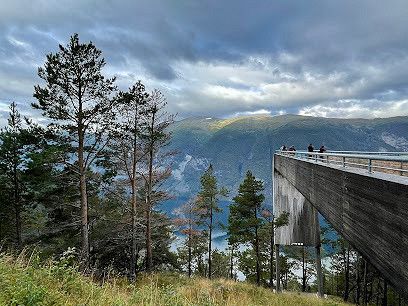
Dalsnibba
Geiranger Skywalk - Dalsnibba,
Geiranger restaurant with a view. Situated on top of the mountain. Such a beautiful place and well worth the visit and drive there.
From Loen take road no. 15 to Dalsnibba
Nibbevegen, Møre og Romsdal, Noorwegen
62° 2' 51.1" N 7° 16' 11" E
62.0475245 7.2697205
• Head south on Nibbevegen. Go for 4.5 km.
• Turn left onto Geirangervegen (63). Go for 7.4 km.
• Turn right onto 15. Go for 51.2 km.
• Take the 1st exit from roundabout onto Nordfjordvegen (15) toward 60/Stranda. Go for 15.8 km.
• Turn right onto E39 toward Ålesund/Volda/Grodås. Go for 8.3 km.
• Turn right onto Hornindalsvegen (60) toward Sykkylven/Stranda/Hellesylt. Go for 52.0 km.
• Continue on Storgata (60) toward Stranda. Go for 1.6 km.
• Take the Stranda-Liabygda Ferry. Stay on for 2.9 km.
• Head east on Gravanesvegen (650). Go for 3.1 km.
• Turn right onto Liabygdvegen (650). Go for 12.7 km.
• Turn left onto 63. Go for 35.2 km.
• Arrive at Isterdalsvegen (63).
☍
194,7 km
(3 hrs. 37 min.)
Trollstigen Utsiktpunkt, Trollstigen, Åndalsnes, Noorwegen
Trollstigen, 6300 Åndalsnes, Noorwegen
62° 27' 15.3" N 7° 40' 8.9" E
62.4542607 7.6691326
• Head southwest on Isterdalsvegen (63). Go for 35.2 km.
• Turn right onto 63. Go for 4.3 km.
• Continue on Lingestranda (650). Go for 38.7 km.
• Turn right onto Giskemovegen (522). Go for 1.0 km.
• Continue on 522. Go for 43 m.
• Continue on Giskemovegen (522). Go for 142 m.
• Continue on Valgermo (522). Go for 97 m.
• Continue on Giskemovegen (522). Go for 176 m.
• Turn right onto Ålesundsvegen (E39/E136). Go for 21.4 km.
• Take the 1st exit from roundabout onto E136 toward Åndalsnes. Go for 43.4 km.
• Continue on 64 toward Åndalsnes. Go for 624 m.
• Take the 2nd exit from roundabout onto Nordsidevegen (64). Go for 32.0 km.
• Continue on Langfjordsstranda (660). Go for 43.9 km.
• Turn right onto Torhusvegen (6012). Go for 675 m.
• Continue on 6012. Go for 15 m.
• Continue on Torhusvegen (6012). Go for 295 m.
• Continue on Slenesvegen (6012). Go for 1.3 km.
• Continue on Slenes (6012). Go for 98 m.
• Continue on Slenesvegen (6012). Go for 268 m.
• Continue on Øvre Slenes (6012). Go for 86 m.
• Continue on Slenesvegen (6012). Go for 1.5 km.
• Continue on 6012. Go for 22 m.
• Continue on Slenesvegen (6012). Go for 399 m.
• Continue on 6012. Go for 14 m.
• Continue on Slenesvegen (6012). Go for 16 m.
• Turn left onto Øveråsvegen (6012). Go for 14 m.
• Continue on 6012. Go for 84 m.
• Continue on Øveråsvegen (6012). Go for 981 m.
• Turn right onto Øveråsvegen (6012). Go for 239 m.
• Continue on 6012. Go for 8.8 km.
• Continue on Eikesdalsvegen (6012). Go for 2.6 km.
• Continue on Vike Øvre (6012). Go for 101 m.
• Continue on Eikesdalsvegen (6012). Go for 790 m.
• Continue on Vikesætra (6012). Go for 87 m.
• Continue on Eikesdalsvegen (6012). Go for 4.4 km.
• Turn left onto Eikesdalsvegen (6012). Go for 34 m.
• Continue on 6012. Go for 746 m.
• Continue on Eikesdalsvegen (6012). Go for 2.7 km.
• Turn slightly right onto Eikesdalsvegen (6012). Go for 498 m.
• Arrive at Eikesdalsvegen (6012). Your destination is on the right.
☍
247,7 km
(3 hrs. 44 min.)
Eikesdalen, Noorwegen
62° 28' 34.1" N 8° 10' 27.6" E
62.4761474 8.1743357
• Head east on Eikesdalsvegen (6012). Go for 3.2 km.
• Continue on 6012. Go for 746 m.
• Continue on Eikesdalsvegen (6012). Go for 4.4 km.
• Continue on Vikesætra (6012). Go for 87 m.
• Continue on Eikesdalsvegen (6012). Go for 790 m.
• Continue on Vike Øvre (6012). Go for 101 m.
• Continue on Eikesdalsvegen (6012). Go for 2.6 km.
• Continue on 6012. Go for 8.8 km.
• Continue on Øveråsvegen (6012). Go for 239 m.
• Turn left onto Øveråsvegen (6012). Go for 981 m.
• Continue on 6012. Go for 84 m.
• Continue on Øveråsvegen (6012). Go for 14 m.
• Turn right onto Slenesvegen (6012). Go for 16 m.
• Continue on 6012. Go for 14 m.
• Continue on Slenesvegen (6012). Go for 399 m.
• Continue on 6012. Go for 22 m.
• Continue on Slenesvegen (6012). Go for 1.5 km.
• Continue on Øvre Slenes (6012). Go for 86 m.
• Continue on Slenesvegen (6012). Go for 268 m.
• Continue on Slenes (6012). Go for 98 m.
• Continue on Slenesvegen (6012). Go for 1.3 km.
• Continue on Torhusvegen (6012). Go for 295 m.
• Continue on 6012. Go for 15 m.
• Continue on Torhusvegen (6012). Go for 675 m.
• Turn left onto Vistdalsheia (660). Go for 43.9 km.
• Continue on Nordsidevegen (64). Go for 31.9 km.
• Take the 3rd exit from roundabout onto Nordsidevegen (64). Go for 672 m.
• Turn left onto Romsdalsvegen (E136). Go for 49.0 km.
• Take the 2nd exit from roundabout onto Romsdalsvegen (E136). Go for 55.5 km.
• Take the 2nd exit from roundabout onto E6 toward Oslo/Otta. Go for 33.7 km.
• Turn sharp right onto 2614. Go for 408 m.
• Continue on Nerøygardsvegen (2614). Go for 1.2 km.
• Turn right onto Vågårustvegen (2620). Go for 2.8 km.
• Continue on Rustvegen (2620). Go for 573 m.
• Continue on Vågårustvegen (2620). Go for 3.3 km.
• Continue on Rustvegen (2620). Go for 6.8 km.
• Turn right onto Ottadalsvegen (15). Go for 3.0 km.
• Pass 2 roundabouts and continue on Vågåvegen (15). Go for 7.4 km.
• Turn left onto Fjellvegen (51) toward Fagernes/Randsverk/Lemonsjøen. Go for 92.2 km.
• Turn right onto Skøltevegen (2508). Go for 4.2 km.
• Continue on Dalsvegen (2508). Go for 2.9 km.
• Continue on Holun (2508). Go for 83 m.
• Continue on Dalsvegen (2508). Go for 741 m.
• Continue on Skjel (2508). Go for 85 m.
• Continue on Dalsvegen (2508). Go for 319 m.
• Continue on Ranisete (2508). Go for 141 m.
• Continue on Dalsvegen (2508). Go for 926 m.
• Continue on 2508. Go for 358 m.
• Continue on Eggeåsvegen (2508). Go for 5.4 km.
• Turn right onto Øygarden (2510). Go for 99 m.
• Continue on Ellestadvegen (2510). Go for 19 m.
• Continue on Hørevegen (2510). Go for 2.1 km.
• Turn left onto Riddarvegen (2510). Go for 2.3 km.
• Turn right onto Tyinvegen (E16). Go for 66.7 km.
• Take the 1st exit from roundabout onto E16 toward Bergen/Lærdal. Go for 28.3 km.
• Take the 2nd exit from roundabout onto E16 toward Bergen/Aurland. Go for 25.1 km.
• Take the 2nd exit from roundabout onto E16 toward Bergen/Voss. Go for 9.1 km.
• Turn left onto Flåmsdalsvegen (5624). Go for 189 m.
• Continue on Flåmsdalsvegen. Go for 131 m.
• Turn left onto Nedre Fretheim. Go for 658 m.
• Turn right onto Fretheimshaugane. Go for 20 m.
• Turn slightly left onto Fretheimshaugane. Go for 15 m.
• Turn right onto Fretheimshaugane. Go for 84 m.
• Arrive at Fretheimshaugane. Your destination is on the right.
☍
508,9 km
(7 hrs. )
Flåm, Noorwegen
60° 51' 38.8" N 7° 6' 42.4" E
60.8607716 7.1117849
• Head northwest on Fretheimshaugane. Go for 84 m.
• Turn left onto Fretheimshaugane. Go for 35 m.
• Turn left onto Nedre Fretheim. Go for 658 m.
• Turn right onto Flåmsdalsvegen. Go for 320 m.
• Turn right onto E16. Go for 9.1 km.
• Take the 1st exit from roundabout onto 50 toward Hol. Go for 94.0 km.
• Turn right onto Mogrendvegen (7) toward Geilo. Go for 11.0 km.
• Take the 3rd exit from roundabout onto Skurdalsvegen (40) toward Kongsberg. Go for 687 m.
• Turn right onto Skurdalsvegen. Go for 220 m.
• Turn left toward Bakkestølvegen. Go for 74 m.
• Turn right onto Bakkestølvegen. Go for 682 m.
• Turn right onto Bakkestølvegen. Go for 417 m.
• Turn right onto Bakkestølvegen. Go for 413 m.
• Arrive at Bakkestølvegen.
☍
117,7 km
(1 hrs. 51 min.)
Geilo, Noorwegen
G59G+6GR Geilo, Noorwegen
60° 31' 5.2" N 8° 10' 34.5" E
60.5181019 8.1762633
• Head northeast on Bakkestølvegen. Go for 428 m.
• Turn slightly right onto Bakkestølvegen. Go for 402 m.
• Turn left onto Bakkestølvegen. Go for 682 m.
• Turn left toward Skurdalsvegen. Go for 74 m.
• Turn right onto Skurdalsvegen. Go for 220 m.
• Turn left onto Skurdalsvegen (40). Go for 659 m.
• Take the 1st exit from roundabout onto Lienvegen (7) toward Oslo/Gol. Go for 48.9 km.
• Take the 2nd exit from roundabout onto Lauvrudvegen (52) toward Lærdal/Hemsedal/Fagernes/Golsfjellet/Gol Sentrum. Go for 1.1 km.
• Turn right onto 51. Go for 45.2 km.
• Take the 2nd exit from roundabout onto Golsvegen (51). Go for 146 m.
• Take the 3rd exit from roundabout onto Oslovegen (E16). Go for 4.3 km.
• Turn right onto Bygdinvegen (51) toward Vågå/Beitostølen. Go for 123 km.
• Turn right onto Ottadalsvegen (15). Go for 5.7 km.
• Pass 2 roundabouts and continue on Ottadalsvegen (15). Go for 4.7 km.
• Turn left onto Rustvegen (2620). Go for 6.8 km.
• Continue on Vågårustvegen (2620). Go for 3.3 km.
• Continue on Rustvegen (2620). Go for 573 m.
• Continue on Vågårustvegen (2620). Go for 2.8 km.
• Turn left onto Nerøygardsvegen (2614). Go for 1.2 km.
• Continue on 2614. Go for 418 m.
• Turn left onto E6. Go for 33.7 km.
• Take the 2nd exit from roundabout onto Romsdalsvegen (E136) toward Ålesund/Åndalsnes. Go for 55.5 km.
• Take the 3rd exit from roundabout onto Romsdalsvegen (E136). Go for 49.0 km.
• Turn right onto 64 toward Molde/Sentrum. Go for 624 m.
• Take the 2nd exit from roundabout onto Nordsidevegen (64). Go for 32.0 km.
• Continue on Langfjordsstranda (660). Go for 43.9 km.
• Turn right onto Torhusvegen (6012). Go for 675 m.
• Continue on 6012. Go for 15 m.
• Continue on Torhusvegen (6012). Go for 295 m.
• Continue on Slenesvegen (6012). Go for 1.3 km.
• Continue on Slenes (6012). Go for 98 m.
• Continue on Slenesvegen (6012). Go for 268 m.
• Continue on Øvre Slenes (6012). Go for 86 m.
• Continue on Slenesvegen (6012). Go for 1.5 km.
• Continue on 6012. Go for 22 m.
• Continue on Slenesvegen (6012). Go for 399 m.
• Continue on 6012. Go for 14 m.
• Continue on Slenesvegen (6012). Go for 16 m.
• Turn left onto Øveråsvegen (6012). Go for 14 m.
• Continue on 6012. Go for 84 m.
• Continue on Øveråsvegen (6012). Go for 981 m.
• Turn right onto Øveråsvegen (6012). Go for 239 m.
• Continue on 6012. Go for 8.8 km.
• Continue on Eikesdalsvegen (6012). Go for 2.6 km.
• Continue on Vike Øvre (6012). Go for 101 m.
• Continue on Eikesdalsvegen (6012). Go for 790 m.
• Continue on Vikesætra (6012). Go for 87 m.
• Continue on Eikesdalsvegen (6012). Go for 4.4 km.
• Turn left onto Eikesdalsvegen (6012). Go for 34 m.
• Continue on 6012. Go for 746 m.
• Continue on Eikesdalsvegen (6012). Go for 2.7 km.
• Turn slightly right onto Eikesdalsvegen (6012). Go for 2.1 km.
• Continue on 6012. Go for 488 m.
• Continue on Eikesdalsvegen (6012). Go for 4.9 km.
• Continue on Setra (6012). Go for 102 m.
• Continue on Eikesdalsvegen (6012). Go for 1.1 km.
• Continue on Reiten (6012). Go for 118 m.
• Continue on Eikesdalsvegen (6012). Go for 2.1 km.
• Continue on Aursjøvegen. Go for 8.1 km.
• Arrive at Aursjøvegen.
☍
510,1 km
(8 hrs. 13 min.)
Aurstaupet, Nesset, Noorwegen
6472 Nesset, Noorwegen
62° 24' 6.7" N 8° 22' 17.6" E
62.4018572 8.3715597
• Head west on Aursjøvegen. Go for 1.2 km.
• Turn slightly right onto Aursjøvegen. Go for 6.9 km.
• Continue on Eikesdalsvegen (6012). Go for 2.1 km.
• Continue on Reiten (6012). Go for 118 m.
• Continue on Eikesdalsvegen (6012). Go for 1.1 km.
• Continue on Setra (6012). Go for 102 m.
• Continue on Eikesdalsvegen (6012). Go for 4.9 km.
• Continue on 6012. Go for 488 m.
• Continue on Eikesdalsvegen (6012). Go for 1.6 km.
• Turn slightly right onto Eikesdalsvegen (6012). Go for 3.3 km.
• Continue on 6012. Go for 746 m.
• Continue on Eikesdalsvegen (6012). Go for 4.4 km.
• Continue on Vikesætra (6012). Go for 87 m.
• Continue on Eikesdalsvegen (6012). Go for 790 m.
• Continue on Vike Øvre (6012). Go for 101 m.
• Continue on Eikesdalsvegen (6012). Go for 2.6 km.
• Continue on 6012. Go for 8.8 km.
• Continue on Øveråsvegen (6012). Go for 239 m.
• Turn left onto Øveråsvegen (6012). Go for 981 m.
• Continue on 6012. Go for 84 m.
• Continue on Øveråsvegen (6012). Go for 14 m.
• Turn right onto Slenesvegen (6012). Go for 16 m.
• Continue on 6012. Go for 14 m.
• Continue on Slenesvegen (6012). Go for 399 m.
• Continue on 6012. Go for 22 m.
• Continue on Slenesvegen (6012). Go for 1.5 km.
• Continue on Øvre Slenes (6012). Go for 86 m.
• Continue on Slenesvegen (6012). Go for 268 m.
• Continue on Slenes (6012). Go for 98 m.
• Continue on Slenesvegen (6012). Go for 1.3 km.
• Continue on Torhusvegen (6012). Go for 295 m.
• Continue on 6012. Go for 15 m.
• Continue on Torhusvegen (6012). Go for 675 m.
• Turn left onto Vistdalsheia (660). Go for 43.9 km.
• Continue on Nordsidevegen (64). Go for 31.9 km.
• Take the 3rd exit from roundabout onto Nordsidevegen (64). Go for 672 m.
• Turn left onto Romsdalsvegen (E136). Go for 49.0 km.
• Take the 2nd exit from roundabout onto Romsdalsvegen (E136). Go for 55.5 km.
• Take the 2nd exit from roundabout onto E6 toward Oslo/Otta. Go for 33.7 km.
• Turn sharp right onto 2614. Go for 408 m.
• Continue on Nerøygardsvegen (2614). Go for 1.2 km.
• Turn right onto Vågårustvegen (2620). Go for 2.8 km.
• Continue on Rustvegen (2620). Go for 573 m.
• Continue on Vågårustvegen (2620). Go for 3.3 km.
• Continue on Rustvegen (2620). Go for 6.8 km.
• Turn right onto Ottadalsvegen (15). Go for 3.0 km.
• Pass 2 roundabouts and continue on Vågåvegen (15). Go for 24.2 km.
• Turn left toward Meadalsvegen. Go for 19 m.
• Turn right onto Meadalsvegen. Go for 372 m.
• Turn slightly right onto Meadalsvegen. Go for 5.6 km.
• Turn left onto Meadalsvegen. Go for 9.2 km.
• Arrive at Meadalsvegen.
☍
317,3 km
(5 hrs. 25 min.)
Jotunheimen national park, hiking, Lom, Noorwegen
Jotunheimen national park, hiking, Lom Municipality, Noorwegen
61° 45' 27.5" N 8° 37' 18.1" E
61.7576513 8.6216828
• Head northwest on Meadalsvegen. Go for 15.2 km.
• Turn left toward Ottadalsvegen/15. Go for 19 m.
• Turn right onto Ottadalsvegen (15). Go for 16.8 km.
• Turn right onto Fjellvegen (51). Go for 71.4 km.
• Turn sharp left toward Lykkjestøladn. Go for 959 m.
• Continue on Lykkjestøladn. Go for 1.3 km.
• Continue on Lykkjestøladn. Go for 815 m.
• Continue on Sendestøladn. Go for 730 m.
• Continue on Sanddalen. Go for 959 m.
• Continue on Sanddalen. Go for 7.6 km.
• Continue on Røsstøladn. Go for 699 m.
• Continue on Listølen. Go for 1.0 km.
• Continue on Mørstadstøladn. Go for 826 m.
• Continue toward Bjødnhølen. Go for 520 m.
• Turn slightly left onto Bjødnhølen. Go for 2.3 km.
• Continue on Langeråk. Go for 10.1 km.
• Continue on Jotunheimvegen. Go for 33 m.
• Arrive at Jotunheimvegen. Your destination is on the left.
☍
131,3 km
(2 hrs. 39 min.)
Jotunheimvegen, Skåbu, Noorwegen
Jotunheimvegen, 2643 Skåbu, Noorwegen
61° 24' 43.1" N 9° 10' 52.1" E
61.4119751 9.1811419
• Head south on Jotunheimvegen. Go for 33 m.
• Continue straight ahead. Go for 2.1 km.
• Keep right. Go for 9 m.
• Turn slightly right toward Bjødnhølen. Go for 4.8 km.
• Continue on Bjødnhølen. Go for 3.2 km.
• Continue on Bjødnhølen. Go for 2.3 km.
• Turn slightly right toward Mørstadstøladn. Go for 520 m.
• Continue on Mørstadstøladn. Go for 826 m.
• Continue on Listølen. Go for 1.0 km.
• Continue on Røsstøladn. Go for 699 m.
• Continue on Urek. Go for 7.6 km.
• Continue on Sanddalen. Go for 959 m.
• Continue on Sendestøladn. Go for 730 m.
• Continue on Lykkjestøladn. Go for 3.0 km.
• Turn left onto 51. Go for 20.8 km.
• Turn right onto Skøltevegen (2508). Go for 4.2 km.
• Continue on Dalsvegen (2508). Go for 2.9 km.
• Continue on Holun (2508). Go for 83 m.
• Continue on Dalsvegen (2508). Go for 741 m.
• Continue on Skjel (2508). Go for 85 m.
• Continue on Dalsvegen (2508). Go for 319 m.
• Continue on Ranisete (2508). Go for 141 m.
• Continue on Dalsvegen (2508). Go for 926 m.
• Continue on 2508. Go for 358 m.
• Continue on Eggeåsvegen (2508). Go for 5.4 km.
• Turn right onto Øygarden (2510). Go for 99 m.
• Continue on Ellestadvegen (2510). Go for 19 m.
• Continue on Hørevegen (2510). Go for 2.1 km.
• Turn left onto Riddarvegen (2510). Go for 2.3 km.
• Turn right onto Tyinvegen (E16). Go for 66.7 km.
• Take the 1st exit from roundabout onto E16 toward Bergen/Lærdal. Go for 28.3 km.
• Take the 2nd exit from roundabout onto E16 toward Bergen/Aurland. Go for 6.7 km.
• Arrive at Lærdalstunnelen (E16).
☍
169,9 km
(2 hrs. 49 min.)
Lærdalstunnelen, Vestland, Noorwegen
61° 0' 44.7" N 7° 27' 6.1" E
61.0124155 7.4516824
• Head northeast on Lærdalstunnelen (E16). Go for 6.7 km.
• Take the 1st exit from roundabout onto E16 toward Oslo/Fagernes. Go for 28.2 km.
• Take the 1st exit from roundabout onto 52 toward 7/Oslo/Gol. Go for 79.3 km.
• Take the 2nd exit from roundabout onto 7 toward Oslo/Hønefoss. Go for 1.5 km.
• Pass 3 roundabouts and continue on 7. Go for 74.5 km.
• Take ramp toward Drammen/35/Hokksund/Noresund/Norefjell. Go for 218 m.
• Take the 1st exit from roundabout onto 280. Go for 15.3 km.
• Take the 2nd exit from roundabout onto Krøderfjordveien (280). Go for 6.5 km.
• Continue on 288. Go for 161 m.
• Take the 1st exit from roundabout onto Krøderfjordveien (288). Go for 34.2 km.
• Continue on 350. Go for 1.8 km.
• Continue on 35. Go for 1.6 km.
• Continue on 350. Go for 975 m.
• Continue on 35. Go for 14.3 km.
• Take the 2nd exit from roundabout onto Ringeriksveien (35). Go for 161 m.
• Take the 2nd exit from roundabout onto Horgenveien (283) toward Drammen. Go for 4.0 km.
• Take the 1st exit from roundabout onto 283. Go for 1.8 km.
• Take the 2nd exit from roundabout onto 283. Go for 1.4 km.
• Take the 1st exit from roundabout onto 283. Go for 411 m.
• Take the 2nd exit from roundabout. Go for 212 m.
• Continue toward E134. Go for 32 m.
• Take the 1st exit from roundabout onto E134 toward Drammen. Go for 11.9 km.
• Take the 3rd exit from roundabout onto E18 toward Kristiansand/Kr. Sand. Go for 116 km.
• Take the 1st exit from roundabout. Go for 235 m.
• Take ramp. Go for 179 m.
• Take the 2nd exit from roundabout onto E18. Go for 61.2 km.
• Take the 1st exit from roundabout onto E18. Go for 98.1 km.
• Take ramp toward Lund Ø/Gimle. Go for 85 m.
• Take the 4th exit from roundabout onto Østerveien (471). Go for 388 m.
• Enter the roundabout. Go for 10 m.
• Arrive at your destination on the right.
☍
561,7 km
(7 hrs. )
Kristiansand, Noorwegen
58° 9' 35.7" N 8° 1' 5.5" E
58.1599119 8.0182064
• Follow the roundabout. Go for 61 m.
• Take the 3rd exit from roundabout onto Østerveien (471). Go for 337 m.
• Take the 1st exit from roundabout onto E18 toward Stavanger/E39/Sentrum. Go for 1.3 km.
• Take ramp toward Vennesla/Lund. Go for 124 m.
• Take the 2nd exit from roundabout onto Torridalsveien (482). Go for 9.0 km.
• Continue on Torridalsvegen (482). Go for 664 m.
• Turn left onto 405. Go for 1.4 km.
• Take the 1st exit from roundabout onto Setesdalsveien (9). Go for 47.5 km.
• Take the 1st exit from roundabout onto Setesdalsvegen (9). Go for 2.4 km.
• Pass 5 roundabouts and continue on Setesdalsvegen (9). Go for 175 km.
• Turn left onto Haukelivegen (E134) toward Haugesund/Røldal. Go for 78.1 km.
• Turn right onto 13 toward Brimnes/Odda/550/Utne/551/48/Rosendal. Go for 17.7 km.
• Pass 2 roundabouts and continue on Butunnelen (13). Go for 58.0 km.
• Take the 2nd exit from roundabout onto Vallaviktunnelen (13). Go for 30.3 km.
• Turn right onto 13 toward E16. Go for 874 m.
• Continue on Strandavegen (E16). Go for 542 m.
• Pass 5 roundabouts and continue on Vinjadalen (E16). Go for 72.2 km.
• Take the 3rd exit from roundabout toward Sentrum. Go for 98 m.
• Continue on Skulevegen (5627). Go for 1.5 km.
• Turn right onto Øvregata. Go for 162 m.
• Continue on Bjørgavegen (5627). Go for 1.7 km.
• Continue on Kvam (5627). Go for 96 m.
• Continue on Bjørgavegen (5627). Go for 6.2 km.
• Arrive at Bjørgavegen (5627). Your destination is on the right.
☍
505,4 km
(7 hrs. 48 min.)
Aurlandsvangen
Stegastein, Aurlandsvangen, Vestland, Noorwegen
60° 54' 31.3" N 7° 12' 43.9" E
60.9086823 7.2122003
• Head north on Bjørgavegen (5627). Go for 6.2 km.
• Continue on Kvam (5627). Go for 96 m.
• Continue on Bjørgavegen (5627). Go for 1.7 km.
• Turn right onto Bjørgavegen (5627). Go for 7 m.
• Continue on Vangen (5627). Go for 93 m.
• Continue on Bjørgavegen (5627). Go for 20 m.
• Continue on Vangen (5627). Go for 26 m.
• Continue on Bjørgavegen (5627). Go for 14 m.
• Turn left onto Vangen (5627). Go for 69 m.
• Continue on Skulevegen (5627). Go for 1.6 km.
• Take the 2nd exit from roundabout onto 50 toward Hol. Go for 94.0 km.
• Turn right onto Mogrendvegen (7) toward Geilo. Go for 11.0 km.
• Take the 3rd exit from roundabout onto Skurdalsvegen (40) toward Kongsberg. Go for 137 km.
• Turn right onto Toskjevegen (2782) toward Toskje/Blefjell S. Go for 734 m.
• Turn left onto Vestsida (2782). Go for 4.9 km.
• Turn right onto Numedalsvegen (40). Go for 16.1 km.
• Pass 2 roundabouts and continue on Numedalsveien (40). Go for 611 m.
• Take the 1st exit from roundabout onto Gomsrudveien (40) toward Larvik. Go for 840 m.
• Pass 4 roundabouts and continue on Gomsrudveien (40). Go for 4.8 km.
• Take the 2nd exit from roundabout onto Skollenborgveien (40). Go for 1.1 km.
• Take the 1st exit from roundabout onto Hostvetveien (40) toward Larvik. Go for 26.7 km.
• Pass 3 roundabouts and continue on Lågendalsveien (40). Go for 52.4 km.
• Take the 3rd exit from roundabout onto Elveveien (40) toward Danmark/Larvik. Go for 410 m.
• Take the 2nd exit from roundabout onto Elveveien (40) toward Danmark/Larvik. Go for 4.4 km.
• Keep left toward Elveveien/40. Go for 35 m.
• Take the 2nd exit from roundabout onto Elveveien (101). Go for 586 m.
• Continue on Elveveien (2984). Go for 86 m.
• Continue on Revet toward Revet Industriområde/Danmark. Go for 118 m.
• Turn right onto Revet. Go for 53 m.
• Turn right onto Revet. Go for 393 m.
• Turn right onto Revet. Go for 88 m.
• Take the Larvik-Hirtshals Ferry. Stay on for 162 km.
• Head southeast on E39. Go for 1.1 km.
• Turn left onto Willemoesvej toward Østhavn. Go for 160 m.
• Turn left onto Østergade. Go for 500 m.
• Take the 3rd exit from roundabout onto Skovvejen. Go for 114 m.
• Turn right onto Lillehedenvej. Go for 268 m.
• Arrive at Lillehedenvej. Your destination is on the left.
☍
530,2 km
(10 hrs. 7 min.)
Hirtshals, Denemarken
9850 Hirtshals, Denemarken
57° 35' 13" N 9° 58' 0.6" E
57.5869530 9.9668379
• Head west on Lillehedenvej. Go for 93 m.
• Turn left onto Margrethevej. Go for 759 m.
• Take the 3rd exit from roundabout onto Søndergade. Go for 1.1 km.
• Turn left onto Dalsagervej (55) toward Hjørring/E39/Skagen/579/Tversted. Go for 82 m.
• Take the 2nd exit from roundabout onto Aalborgvej (E39) toward Aalborg/Skagen/597. Go for 2.2 km.
• Take the 2nd exit from roundabout onto E39 (Hirtshalsmotorvejen) toward Aalborg. Go for 57.0 km.
• Continue on Vendsyssel. Go for 196 m.
• Continue on E45 (Vendsyssel). Go for 113 km.
• Take the exit toward Lufthavn/Grenaa/Hospital Skejby/Århus N/180 onto 15 (Djurslandmotorvejen). Go for 3.0 km.
• Take ramp toward Skejby/Færge Århus N/Hospital. Go for 884 m.
• Continue on Søftenvej. Go for 3.8 km.
• Continue on Randersvej toward O1/Centrum. Go for 1.3 km.
• Continue on Nørrebrogade (O1) toward Centrum. Go for 1.5 km.
• Turn right onto Kystvejen (O1). Go for 3.5 km.
• Turn right onto Oddervej. Go for 1.6 km.
• Turn left onto Grumstolsvej. Go for 1.3 km.
• Turn left onto Hørhavevej. Go for 227 m.
• Turn right onto Ørneredevej. Go for 403 m.
• Arrive at Ørneredevej. Your destination is on the left.
☍
192,4 km
(2 hrs. 2 min.)
DCU-Camping Aarhus - Blommehaven
Ørneredevej 35, 8270, Højbjerg, Denmark
56° 6' 38" N 10° 13' 56" E
56.1105600 10.2322200
• Head northwest on Ørneredevej. Go for 403 m.
• Turn left onto Hørhavevej. Go for 227 m.
• Turn right onto Grumstolsvej. Go for 1.3 km.
• Turn right onto Oddervej. Go for 1.6 km.
• Turn left onto Strandvejen. Go for 1.5 km.
• Turn left onto Marselis Boulevard (O1). Go for 895 m.
• Continue on Marselis Boulevard toward E45/170/180. Go for 1.3 km.
• Continue on Åhavevej. Go for 906 m.
• Keep left onto 501 (Århus Syd Motorvejen). Go for 9.9 km.
• Continue on E45 (Østjyske Motorvej). Go for 81.6 km.
• Continue on E45 (Sønderjyske Motorvej) toward Flensborg. Go for 73.9 km.
• Take exit 74 toward Kruså/Flensborg N/170 onto Aabenraavej. Go for 5.6 km.
• Continue on B200. Go for 9.6 km.
• Take ramp onto Osttangente (B199) toward Kappeln/Glücksburg/Sörup/Satrup/Flensburg-Süd. Go for 2.2 km.
• Turn right onto Eckernförder Landstraße (L23) toward Sörup/Satrup. Go for 904 m.
• Take the 1st exit from roundabout onto Eckernförder Landstraße (L23). Go for 6.3 km.
• Turn left onto Flensburger Straße (L23). Go for 1.1 km.
• Arrive at Flensburger Straße (L23). Your destination is on the right.
☍
199,2 km
(2 hrs. 13 min.)
Stellplatz Nördliche Ziele
Flensburger Straße 20, 24991, Großsolt, Germany
54° 42' 31" N 9° 31' 20" E
54.7086111 9.5222222
• Head toward Estruper Weg on Flensburger Straße (L23). Go for 620 m.
• Take the 1st exit from roundabout onto Neue Straße (L193). Go for 8.3 km.
• Take the 2nd exit from roundabout onto L15 toward Tarp. Go for 1.1 km.
• Turn left and take ramp onto A7 toward Hamburg/Kiel. Go for 139 km.
• Keep left onto A7. Go for 14.7 km.
• Keep right onto A261 (Autobahndreieck Hamburg-Südwest) toward Bremen/Tötensen. Go for 9.0 km.
• Take exit 4 toward Osnabrück/Bremen/Rade onto A1. Go for 231 km.
• Take exit 76 toward Greven/Nordwalde/Telgte/Münster-Ost. Go for 426 m.
• Continue on Schiffahrter Damm (B481). Go for 3.6 km.
• Take ramp onto Fuestruper Straße (K55). Go for 2.0 km.
• Turn left onto Fuestruper Straße. Go for 287 m.
• Arrive at Fuestruper Straße. Your destination is on the left.
☍
409,9 km
(3 hrs. 53 min.)
Camp Marina Alte Fahrt
Fuestruper Straße 37, 48268, Greven, Germany
52° 2' 42" N 7° 41' 6" E
52.0450000 7.6850000
• Head west on Fuestruper Straße. Go for 287 m.
• Turn right onto Fuestruper Straße (K55). Go for 1.8 km.
• Turn right onto Telgter Straße (L588). Go for 251 m.
• Turn right and take ramp onto Schiffahrter Damm (B481). Go for 4.1 km.
• Turn left and take ramp onto A1 (Hansalinie) toward Dortmund. Go for 19.9 km.
• Take exit 78 toward Recklinghausen/Dülmen onto A43. Go for 21.5 km.
• Take exit 5 toward Dülmen-Nord/Olfen/Coesfeld/Bocholt/B67 onto B474. Go for 3.8 km.
• Continue on B67. Go for 2.5 km.
• Take ramp toward Merfeld. Go for 188 m.
• Turn left toward Merfeld. Go for 145 m.
• Take the 2nd exit from roundabout onto Roruper Straße (L600) toward Merfeld/Wildpferdebahn/A31/Bocholt/Borken. Go for 696 m.
• Turn right onto Rekener Straße (L600). Go for 8.9 km.
• Continue on Stevede (B67). Go for 47.0 km.
• Take ramp onto A3 toward Arnheim. Go for 22.0 km.
• Continue on A12. Go for 28.7 km.
• Take the exit toward Rotterdam/Eindhoven/Nijmegen onto A50. Go for 31.5 km.
• Take exit 17 toward Ravenstein. Go for 392 m.
• Take the 3rd exit from roundabout onto Dorpenweg (N626) toward Ravenstein. Go for 568 m.
• Pass 6 roundabouts and continue on Dorpenweg (N626). Go for 9.0 km.
• Continue on Beatrixweg. Go for 1.4 km.
• Take the 2nd exit from roundabout onto Beatrixweg. Go for 2.5 km.
• Take the 1st exit from roundabout onto John F. Kennedybaan (N625). Go for 3.6 km.
• Turn right onto Marktplein. Go for 33 m.
• Arrive at Marktplein. Your destination is on the left.
☍
210,8 km
(2 hrs. 30 min.)
Lith, Nederland
5397 Lith, Nederland
51° 48' 23.6" N 5° 26' 24" E
51.8065563 5.4399971
• Head toward Molenstraat on Marktplein. Go for 33 m.
• Turn left onto Marktplein (N625). Go for 3.6 km.
• Take the 2nd exit from roundabout onto Beatrixweg. Go for 2.5 km.
• Take the 2nd exit from roundabout onto Beatrixweg. Go for 1.5 km.
• Continue on Dorpenweg (N626). Go for 1.3 km.
• Pass 7 roundabouts and continue on Dorpenweg (N277). Go for 8.7 km.
• Turn right onto Erfsestraat toward Nijmegen/Herpen/Bedrijvenlocatie de Bulk. Go for 337 m.
• Turn right and take ramp onto A50 toward Nijmegen/Arnhem. Go for 11.2 km.
• Keep left onto A50. Go for 19.2 km.
• Take the exit toward Zwolle/Apeldoorn/Oberhausen/Arnhem onto A12/A50. Go for 6.5 km.
• Take the exit toward Apeldoorn/Zwolle onto A50. Go for 21.8 km.
• Take the exit toward Hengelo/Deventer onto A1. Go for 49.0 km.
• Take the exit toward Osnabrück/Enschede/Hengelo onto A1/A35. Go for 3.9 km.
• Continue on A1 toward Osnabrück/Hengelo/Borne. Go for 23.4 km.
• Continue on A30. Go for 64.0 km.
• Take exit 14 toward Bremen/Osnabrück-Hafen onto A1 (Hansalinie). Go for 213 km.
• Take the exit toward Lübeck/Berlin/Hamburg onto A1. Go for 14.6 km.
• Take exit 36 toward Lübeck/Berlin/Hamburg-Südost onto A1. Go for 129 km.
• Continue on B207. Go for 21.2 km.
• Keep left onto B207 toward Puttgarden. Go for 126 m.
• Continue on E47. Go for 836 m.
• Take the Puttgarden-Rødby Ferry. Stay on for 18.7 km.
• Head northeast. Go for 768 m.
• Keep left toward København/E47. Go for 135 m.
• Continue on Sydmotorvejen (E47). Go for 121 km.
• Continue on E20/E47 (Køge Vest). Go for 26.2 km.
• Continue on E20 (Avedøre) toward Malmø/Lufthavn/København C. Go for 27.7 km.
• Continue on E20 (Öresundsbron). Go for 27.8 km.
• Continue on E6/E20 toward E4/Göteborg/Stockholm. Go for 56.8 km.
• Continue on E6/E20 toward Göteborg/Höganäs/111/Helsingborg N. Go for 207 km.
• Keep right onto E6 (Olskroksmotet). Go for 104 km.
• Take exit 102 toward Dingle/Hunnebostrand/Bovallstrand. Go for 359 m.
• Turn right onto Rom Mellangård (174). Go for 1.2 km.
• Turn left onto Kustvägen. Go for 984 m.
• Continue on Stockebro. Go for 643 m.
• Continue on Staxäng. Go for 661 m.
• Continue on Svarteborgs-Medbo. Go for 3.9 km.
• Continue on Humlekärr. Go for 834 m.
• Turn right onto 163. Go for 851 m.
• Continue on Hekullen. Go for 503 m.
• Continue on Grind. Go for 1.9 km.
• Continue on Nytorp. Go for 671 m.
• Continue on Björkhaga. Go for 260 m.
• Continue on Lundby. Go for 273 m.
• Turn left toward Klev. Go for 1.3 km.
• Continue on Klev. Go for 733 m.
• Continue on Klev Tyftet. Go for 1.9 km.
• Continue on Riksvägen. Go for 227 m.
• Continue on Tallstigen. Go for 276 m.
• Continue on Riksvägen. Go for 786 m.
• Turn left and take ramp onto E6 toward Strömstad. Go for 59.2 km.
• Continue on E6 (Svinesundsbroen). Go for 91.9 km.
• Continue on E6 toward Trondheim/Ring 3/Oslo N/Ø. Go for 18.3 km.
• Take ramp toward E18/Kristiansand/Sentrum. Go for 237 m.
• Take the 3rd exit from roundabout toward Sentrum/E18. Go for 195 m.
• Continue on Operatunnelen. Go for 1.4 km.
• Take left ramp onto Operatunnelen (190) toward E18/Sentrum. Go for 4.8 km.
• Keep left onto Frognerstranda (E18). Go for 11.7 km.
• Take the exit toward Bergen/Hønefoss onto E16 (Bjørnegårdtunnelen). Go for 8.4 km.
• Keep right toward E16. Go for 7.5 km.
• Continue on E16. Go for 21.0 km.
• Take the 2nd exit from roundabout onto Osloveien (E16). Go for 6.0 km.
• Take the 2nd exit from roundabout onto Soknedalsveien (7) toward Bergen/Gol/Geilo/Bergen/Via Gol. Go for 20.5 km.
• Pass 5 roundabouts and continue on Rotneimvegen (7). Go for 130 km.
• Turn right onto Holsfjordvegen (50) toward Aurland/Hovet/Hol sentrum. Go for 94.0 km.
• Take the 2nd exit from roundabout. Go for 72 m.
• Continue on Skulevegen (5627). Go for 1.5 km.
• Turn right onto Øvregata. Go for 162 m.
• Continue on Bjørgavegen (5627). Go for 1.7 km.
• Continue on Kvam (5627). Go for 96 m.
• Continue on Bjørgavegen (5627). Go for 6.2 km.
• Arrive at Bjørgavegen (5627). Your destination is on the right.
☍
1,689,1 km
(18 hrs. 47 min.)
Aurlandsvangen
Stegastein, Aurlandsvangen, Vestland, Noorwegen
60° 54' 31.1" N 7° 12' 42.4" E
60.9086345 7.2117732
• Head north on Bjørgavegen (5627). Go for 6.2 km.
• Continue on Kvam (5627). Go for 96 m.
• Continue on Bjørgavegen (5627). Go for 1.7 km.
• Turn right onto Bjørgavegen (5627). Go for 7 m.
• Continue on Vangen (5627). Go for 93 m.
• Continue on Bjørgavegen (5627). Go for 20 m.
• Continue on Vangen (5627). Go for 26 m.
• Continue on Bjørgavegen (5627). Go for 14 m.
• Turn left onto Vangen (5627). Go for 69 m.
• Continue on Skulevegen (5627). Go for 1.6 km.
• Take the 2nd exit from roundabout onto 50 toward Hol. Go for 94.0 km.
• Turn left onto Mogrendvegen (7) toward Oslo/Gol. Go for 37.9 km.
• Pass 4 roundabouts and continue on 7. Go for 91.9 km.
• Take the 3rd exit from roundabout onto Hallingdalsveien (7) toward Oslo/Hønefoss. Go for 20.5 km.
• Take the 1st exit from roundabout onto E16 toward Oslo/Hokksund/35. Go for 5.9 km.
• Take the 1st exit from roundabout onto Osloveien (E16). Go for 20.3 km.
• Take ramp onto Skarveien (285) toward Drammen. Go for 1.3 km.
• Take the 1st exit from roundabout onto Lierveien (285). Go for 20.8 km.
• Take the 3rd exit from roundabout onto Kirkelina (282). Go for 1.9 km.
• Pass 3 roundabouts and continue on Lierbakkene (282). Go for 6.3 km.
• Turn left onto Tuverudveien (2694). Go for 598 m.
• Continue on Kirkeveien (2694). Go for 154 m.
• Continue on Tuverudveien (2694). Go for 1.2 km.
• Continue toward Drøbak. Go for 31 m.
• Turn slightly left onto Røykenveien (E134) toward Drøbak. Go for 244 m.
• Pass 2 roundabouts and continue on Røykenveien (E134). Go for 4.9 km.
• Take the 1st exit from roundabout onto E134 toward Drøbak/Røyken/Tofte/281/Gøteborg/E6/Stockholm/E18. Go for 5.2 km.
• Pass 6 roundabouts and continue on E134. Go for 26.8 km.
• Take the 1st exit from roundabout onto E6 toward Oslo/E18/Stockholm. Go for 4.4 km.
• Take the exit toward Vinterbro/Stockholm/Ski/154. Go for 230 m.
• Take the 2nd exit from roundabout toward Stockholm/154/Ski. Go for 245 m.
• Continue on E18. Go for 6.2 km.
• Take the 2nd exit from roundabout onto E18 toward Askim. Go for 63.6 km.
• Continue on E18. Go for 61.0 km.
• Turn right toward Åmål/Svaneholm. Go for 643 m.
• Continue on Kettilsbyn Hagbacken. Go for 4.2 km.
• Continue on Hallanda Stationen. Go for 2.0 km.
• Continue on Strand Solhem. Go for 731 m.
• Continue on Strandvägen. Go for 609 m.
• Turn right onto Storgatan. Go for 2.8 km.
• Continue on Södra Skarbol Svanvik. Go for 4.7 km.
• Continue on Mo Kroken. Go for 2.4 km.
• Continue on Persbyn. Go for 1.6 km.
• Continue on Mo Byn. Go for 1.4 km.
• Continue on Mo Stom. Go for 3.9 km.
• Turn right onto E45. Go for 3.2 km.
• Take the 2nd exit from roundabout onto E45 toward Göteborg/Åmål C. Go for 21.3 km.
• Turn left onto Krusebol. Go for 393 m.
• Continue on Ånimskogs Hult. Go for 722 m.
• Continue on Lågen. Go for 261 m.
• Continue on Östra Berg. Go for 696 m.
• Continue on Hängele. Go for 1.4 km.
• Turn slightly left onto Hängele. Go for 546 m.
• Turn slightly right onto Östra Bodane. Go for 2.3 km.
• Arrive at Östra Bodane.
☍
541,2 km
(8 hrs. )
Västra Götalands län, Zweden
58° 50' 53.2" N 12° 38' 0.7" E
58.8481005 12.6335341
• Head north on Östra Bodane. Go for 2.3 km.
• Turn slightly left onto Hängele. Go for 1.9 km.
• Continue on Östra Berg. Go for 696 m.
• Continue on Lågen. Go for 261 m.
• Continue on Ånimskogs Hult. Go for 435 m.
• Continue on Ånimskogs Hult. Go for 287 m.
• Continue on Krusebol. Go for 393 m.
• Turn left onto E45. Go for 23.2 km.
• Take the 1st exit from roundabout onto Kornsjögatan (166) toward Ed/Bäckefors/172/Bengtsfors. Go for 25.0 km.
• Turn left onto 166. Go for 13.7 km.
• Turn left onto 164/166. Go for 12.6 km.
• Turn right onto 166 toward Halden. Go for 9.8 km.
• Continue on Kornsjøveien (884). Go for 11.9 km.
• Turn right onto Aspedamveien (884). Go for 9.1 km.
• Continue on Bøklevene (884). Go for 2.7 km.
• Continue on Aspedamveien (884). Go for 1.3 km.
• Turn right onto 220. Go for 5.8 km.
• Turn right onto Olav Vs gate (220) toward 21/E6/Mysen. Go for 176 m.
• Turn left onto Bakbanken. Go for 46 m.
• Continue on Fisketorget. Go for 148 m.
• Take the 2nd exit from roundabout onto Walkers gate. Go for 262 m.
• Take the 2nd exit from roundabout onto Walkers gate. Go for 137 m.
• Take the 1st exit from roundabout onto Fridtjof Nansens gate. Go for 253 m.
• Continue on Heimdalsveien. Go for 106 m.
• Continue on Fridtjof Nansens gate. Go for 68 m.
• Take the 2nd exit from roundabout onto Marcus Thranes gate (204). Go for 3.9 km.
• Take the 2nd exit from roundabout onto Svinesundsveien (204). Go for 2.6 km.
• Take the 3rd exit from roundabout toward E6/Oslo/Gøteborg. Go for 122 m.
• Take ramp onto E6 (Osloveien) toward Oslo. Go for 52.2 km.
• Take exit 14 toward Moss/Horten/E18/Elvestad. Go for 382 m.
• Take the 3rd exit from roundabout onto Vålerveien (19) toward Moss/Ferge Horten/E18/Oslo/E6. Go for 261 m.
• Take the 2nd exit from roundabout onto Innfartsveien (19) toward Moss/E18/Horten. Go for 2.4 km.
• Take the 1st exit from roundabout onto Vogts gate (19) toward Horten/Jeløy/Sentrum. Go for 541 m.
• Take the 2nd exit from roundabout onto Kransen (19) toward Horten/Jeløy. Go for 449 m.
• Take the 2nd exit from roundabout onto Østre Kanalgate (19) toward Horten. Go for 134 m.
• Keep right onto Østre Kanalgate (19) toward Horten. Go for 296 m.
• Take the Moss-Horten Ferry. Stay on for 10.8 km.
• Head northwest on 19. Go for 473 m.
• Take the 1st exit from roundabout onto Linden (19). Go for 96 m.
• Take the 2nd exit from roundabout onto Midgardsveien (19) toward E18/325/Tønsberg. Go for 3.0 km.
• Pass 2 roundabouts and continue on Knudstadveien (19). Go for 5.4 km.
• Take the 3rd exit from roundabout onto E18 toward Kristiansand/Larvik. Go for 69.3 km.
• Take the 1st exit from roundabout. Go for 235 m.
• Take ramp. Go for 179 m.
• Take the 2nd exit from roundabout onto E18. Go for 61.2 km.
• Pass 2 roundabouts and continue on E39 (Fidjebakken). Go for 131 km.
• Take the exit. Go for 749 m.
• Take the 2nd exit from roundabout onto E39. Go for 180 m.
• Pass 4 roundabouts and continue on Mandalsveien (E39). Go for 21.1 km.
• Take the 1st exit from roundabout onto Mandalsveien (E39) toward Stavanger. Go for 3.2 km.
• Take the 1st exit from roundabout onto Mandalsveien (E39) toward Stavanger. Go for 8.7 km.
• Take the 1st exit from roundabout. Go for 912 m.
• Take the 1st exit from roundabout onto E39. Go for 36.9 km.
• Take ramp toward 44/Sokndal/Flekkefjord/Sentrum/Sykehus. Go for 277 m.
• Continue toward Austadveien/44. Go for 28 m.
• Take the 2nd exit from roundabout onto Austadveien (44). Go for 29.3 km.
• Turn left onto 4240. Go for 101 m.
• Arrive at 4240. Your destination is on the right.
☍
568,3 km
(7 hrs. 59 min.)
Hauge
Buveien 7, Hauge, Rogaland, Noorwegen
58° 19' 3" N 6° 20' 38.8" E
58.3175022 6.3441031