We are sailing from Dunkirk to Rosslare so we are not going via England as this route indicates
Lith
Zuster Allegondastraat 9, Lith, Noord-Brabant, Nederland
51° 48' 26.7" N 5° 26' 15.3" E
51.8074104 5.4375863
• Head toward Pastoor van Hapertstraat on Zuster Allegondastraat. Go for 66 m.
• Turn left onto Pastoor van Hapertstraat. Go for 210 m.
• Continue on Kapelstraat. Go for 243 m.
• Turn right onto Meester van Coothstraat (N625). Go for 2.7 km.
• Take the 2nd exit from roundabout onto Provincialeweg (N625). Go for 8.6 km.
• Continue on De Blauwe Sluisweg. Go for 443 m.
• Pass 2 roundabouts and continue on De Blauwe Sluisweg (N625). Go for 851 m.
• Keep right toward De Blauwe Sluisweg/N625. Go for 54 m.
• Take the 2nd exit from roundabout onto De Blauwe Sluisweg (N625). Go for 870 m.
• Keep right toward Waalwijk/Utrecht/Eindhoven/'s-Hertogenbosch. Go for 34 m.
• Take the 1st exit from roundabout onto Bruistensingel toward Waalwijk/Utrecht/Eindhoven/'s-Hertogenbosch. Go for 371 m.
• Turn left toward Waalwijk/Utrecht/Industrieterrein 3700-3900. Go for 207 m.
• Turn right and take ramp onto A2/A59 (Ring 's-Hertogenbosch) toward Waalwijk/Utrecht. Go for 1.1 km.
• Take the exit toward Ring-Noord/Waalwijk onto A59 (Ring 's-Hertogenbosch). Go for 32.6 km.
• Keep left toward Oosterhout/Breda. Go for 263 m.
• Turn slightly left and take ramp onto A27. Go for 16.1 km.
• Take the exit toward Roosendaal/Antwerpen/Industrieterrein Breda 0-7000 onto A58. Go for 6.3 km.
• Take the left exit toward E19/Antwerpen onto A16. Go for 5.9 km.
• Continue on E19. Go for 41.8 km.
• Continue on E19 (Ring Antwerpen 1). Go for 2.4 km.
• Continue on E34 (Kleine Ring) toward Brugge/Gent/Haven 1000-2000. Go for 5.2 km.
• Continue on E17. Go for 49.5 km.
• Take the exit toward Brussel/Oostende onto E40. Go for 81.4 km.
• Take exit 2 toward Diksmuide/Oostduinkerke. Go for 457 m.
• Turn left onto Toekomstlaan (N330) toward Diksmuide. Go for 1.2 km.
• Take the 1st exit from roundabout onto Brugse Steenweg (N35) toward Veurne. Go for 720 m.
• Turn left onto Knollestraat toward Steenkerke/Eggewaartskapelle. Go for 911 m.
• Turn right onto Julaenestraat. Go for 2.1 km.
• Continue on Haenestraat. Go for 813 m.
• Continue on Steenkerkestraat. Go for 26 m.
• Arrive at Steenkerkestraat. Your destination is on the right.
☍
263,4 km
(2 hrs. 31 min.)
Veurne
Sint Laurentiusstraat, 8630 Veurne, BelgiumPhone: +32 477 40 17 65
Steenkerkestraat, Veurne, Veurne, West-Vlaanderen, België
51° 3' 27.9" N 2° 41' 20.6" E
51.0577387 2.6890444
• Head southeast on Steenkerkestraat. Go for 9 m.
• Turn right onto Steengracht West. Go for 1.8 km.
• Turn right onto Ieperse Steenweg (N8). Go for 920 m.
• Take the 2nd exit from roundabout onto Europalaan (N8) toward Koksijde/De Panne/Veurne. Go for 206 m.
• Take ramp toward E40/Diksmuide/N35/Bulskamp. Go for 234 m.
• Take the 4th exit from roundabout toward E40/Ieper. Go for 275 m.
• Take ramp onto E40 toward Calais/Adinkerke. Go for 8.0 km.
• Continue on A16 (Autoroute des Estuaires). Go for 20.5 km.
• Take exit 54B toward Port-3000 à 3800 onto D131. Go for 873 m.
• Take the 1st exit from roundabout onto D131. Go for 410 m.
• Take the 3rd exit from roundabout onto D601. Go for 6.2 km.
• Take the 1st exit from roundabout onto Route de la Maison Blanche. Go for 582 m.
• Arrive at Route de la Maison Blanche.
☍
40,0 km
( 28 min.)
Loon
Route de la Maison Blanche, Loon, Noorderdepartement, Hauts-de-France, Frankrijk
51° 0' 0.7" N 2° 11' 51.3" E
51.0001972 2.1975759
• Head toward Carrefour des Continents on Route de la Maison Blanche. Go for 45 m.
• Take the 5th exit from Carrefour des Continents roundabout. Go for 1.3 km.
• Keep right toward N316. Go for 223 m.
• Continue on N316. Go for 1.7 km.
• Take the 3rd exit from Rond-Point de l'Europe roundabout onto N316. Go for 733 m.
• Take the 1st exit from roundabout onto A16 (Autoroute des Estuaires) toward Calais/Gravelines/Tunnel/S la Manche. Go for 29.7 km.
• Take exit 42 toward Tunnel S/S la Manche/Tunnel sous la Manche onto E15. Go for 978 m.
• Keep right onto E15. Go for 111 m.
• Take the 3rd exit from roundabout. Go for 724 m.
• Take the 2nd exit from roundabout. Go for 809 m.
• Turn right. Go for 89 m.
• Turn left. Go for 146 m.
• Turn right. Go for 103 m.
• Keep right. Go for 20 m.
• Take the Channel Tunnel car shuttle train. Stay on for 57.6 km.
• Head northeast. Go for 2.7 km.
• Take right ramp onto M20 toward London/Ashford. Go for 60.7 km.
• Keep left onto M26 toward Heathrow Airport/(M25(W))/Gatwick Airport/Sevenoaks/(A25). Go for 15.6 km.
• Keep right onto M26. Go for 170 m.
• Continue on M25. Go for 46.2 km.
• Take exit 10 toward Guildford/Portsmouth. Go for 1.1 km.
• Take ramp onto Portsmouth Road (A3). Go for 11.3 km.
• Keep right onto A3 toward Portsmouth/Petersfield. Go for 35.3 km.
• Take the 2nd exit from roundabout onto A3 toward Petersfield/Portsmouth. Go for 18.0 km.
• Keep right onto A3(M) toward Portsmouth/Hayling Island. Go for 9.2 km.
• Take the exit onto A27. Go for 1.6 km.
• Keep right onto A27 toward Southampton/Portsmouth (W)/City Centre/(M27). Go for 2.2 km.
• Keep right onto M27 toward The West/Southampton/Fareham/Portsmouth/(M275). Go for 844 m.
• Take exit 12 toward Portsmouth onto M275. Go for 3.7 km.
• Keep left onto A3. Go for 467 m.
• Take the 2nd exit from Church Street Roundabout roundabout onto Commercial Road (A3) toward City Centre/Seafront. Go for 299 m.
• Take the 2nd exit from Marketway Roundabout roundabout onto Marketway (A3). Go for 277 m.
• Take the 2nd exit from roundabout onto Marketway (A3) toward Seafront. Go for 831 m.
• Keep left onto Anglesea Road (A3). Go for 202 m.
• Keep right onto Lord Montgomery Way (A3). Go for 190 m.
• Keep right onto St Michaels Road (A3) toward (M275)/(M27). Go for 36 m.
• Keep left onto Cambridge Road (A3). Go for 350 m.
• Take the 3rd exit from roundabout onto St George's Road (B2154). Go for 376 m.
• Continue on Gunwharf Road. Go for 294 m.
• Turn right. Go for 69 m.
• Turn left. Go for 105 m.
• Turn left. Go for 46 m.
• Take the Portsmouth-Fishbourne Ferry. Stay on for 10.2 km.
• Head toward Fishbourne Lane. Go for 292 m.
• Turn right onto Fishbourne Lane (B3331). Go for 720 m.
• Turn right onto Kite Hill (A3054). Go for 3.3 km.
• Take the 1st exit from roundabout onto Racecourse (A3054). Go for 3.5 km.
• Continue on Coppins Bridge (A3020). Go for 100 m.
• Turn right onto Coppins Bridge (A3020). Go for 36 m.
• Turn left onto East Street (B3323). Go for 103 m.
• Take the 2nd exit from roundabout onto South Street (B3323). Go for 343 m.
• Keep right onto St James Street (B3323). Go for 70 m.
• Turn left onto Pyle Street (B3323). Go for 257 m.
• Continue on Carisbrooke Road (B3323). Go for 720 m.
• Take the 1st exit from roundabout onto Carisbrooke Road (B3323). Go for 356 m.
• Take the 2nd exit from roundabout onto High Street (B3401). Go for 440 m.
• Take the 2nd exit from roundabout onto Carisbrooke High Street (B3401). Go for 144 m.
• Continue on High Street (B3401). Go for 60 m.
• Continue on Calbourne Road (B3401). Go for 3.7 km.
• Continue on B3401. Go for 2.1 km.
• Continue on Sun Hill (B3401). Go for 265 m.
• Turn right onto Elm Lane. Go for 573 m.
• Arrive at Elm Lane.
☍
333,8 km
(5 hrs. 21 min.)
Calbourne
Thornhurst, Elm Lane, Calbourne, Isle of Wight, Engeland, PO30 4JS, Verenigd Koninkrijk
50° 41' 4" N 1° 23' 54.3" W
50.6844506 -1.3984206
• Head toward Quarry Lane on Elm Lane. Go for 1.8 km.
• Continue on Main Road (A3054). Go for 6.9 km.
• Take the 1st exit from roundabout onto A3054. Go for 102 m.
• Turn right. Go for 132 m.
• Turn left. Go for 133 m.
• Take the Lymington-Yarmouth Ferry. Stay on for 6.2 km.
• Head north. Go for 255 m.
• Turn left onto Undershore Road. Go for 682 m.
• Turn left onto Bridge Road (B3054) toward Lymington/New Milton/Lyndhurst/Southampton/(A337). Go for 414 m.
• Take the 2nd exit from roundabout onto Gosport Street (B3054) toward Lyndhurst/Christchurch/New Milton/(A337)/Southampton/(A35). Go for 97 m.
• Take the 2nd exit from roundabout onto Marsh Lane (B3054). Go for 1.2 km.
• Take the 2nd exit from roundabout onto A337 toward Lyndhurst/Brockenhurst/Southampton/(A35). Go for 400 m.
• Take the 1st exit from roundabout onto Passford Hill (A337). Go for 11.0 km.
• Keep right onto Shrubbs Hill Road (A337). Go for 649 m.
• Keep right onto High Street (A35) toward Southampton/(M27)/Ringwood/(A31)/Cadnam/A337. Go for 220 m.
• Turn left onto Romsey Road (A337). Go for 5.3 km.
• Take the 1st exit from roundabout onto A336 toward Bramshaw. Go for 531 m.
• Take the 3rd exit from roundabout onto M27 toward Brook/Bramshaw/Fordingbridge/B3079/Fritham/Bolderwood/Linwood/London/Southampton/Winchester. Go for 13.4 km.
• Take exit 4 toward The MIDLANDS/London/Winchester onto M27. Go for 2.6 km.
• Continue on M3. Go for 13.9 km.
• Take exit 9 toward The Midlands/Newbury. Go for 399 m.
• Take the 2nd exit from roundabout onto Winchester By-pass (A34) toward The MIDLANDS/Newbury/Andover/(A303)/Salisbury/(A30)/Basingstoke/(A33). Go for 1.5 km.
• Keep left onto A34 toward (A30)/(A303)/S. Scotney/Whitchurch/Stockbridge. Go for 40.1 km.
• Take ramp toward Hungerford/Newbury. Go for 345 m.
• Turn left toward B4000. Go for 45 m.
• Take the 3rd exit from roundabout onto B4000 toward Wickham/Stockcross. Go for 1.5 km.
• Continue on Ermin Street (B4000). Go for 90 m.
• Continue on B4000. Go for 2.9 km.
• Continue on Newbury Road (B4000). Go for 2.1 km.
• Continue on Baydon Road (B4000). Go for 3.1 km.
• Continue on Ermine Street (B4000). Go for 363 m.
• Turn left onto Baydon Road (A338). Go for 858 m.
• Take the 3rd exit from roundabout onto M4 toward South Wales/Bristol/Swindon (W). Go for 213 km.
• Take the 2nd exit from roundabout onto A48 toward Caerfyrddin/Carmarthen. Go for 6.1 km.
• Take the 3rd exit from roundabout onto A48 toward Caerfyrddin/Carmarthen. Go for 17.8 km.
• Take the 2nd exit from Pensarn Roundabout roundabout onto Pont Lesneven (A40) toward Abergwaun/Fishguard/Sanclêr/St Clears. Go for 784 m.
• Take the 1st exit from Pont Lesneven Roundabout roundabout onto A40 toward Abergwaun/Fishguard/Sancler/St Clears. Go for 14.0 km.
• Take the 2nd exit from roundabout onto A40 toward Abergwaun/Fishguard/Hwlffordd/Haverfordwest. Go for 6.5 km.
• Pass 3 roundabouts and continue on A40. Go for 9.9 km.
• Take the 3rd exit from Penblewin roundabout onto A40 toward Abergwaun/Fishguard/Hwlffordd/Haverfordwest. Go for 3.4 km.
• Pass 2 roundabouts and continue on A40. Go for 13.2 km.
• Take the 2nd exit from Scotchwell roundabout onto A40 toward Abergwaun/Fishguard/Aberteifi/Cardigan. Go for 1.3 km.
• Take the 2nd exit from Cardigan Road roundabout onto A40 toward Abergwaun/Fishguard. Go for 500 m.
• Take the 3rd exit from Withybush roundabout onto A40 toward Abergwaun/Fishguard. Go for 20.3 km.
• Pass 2 roundabouts and continue on A40. Go for 2.0 km.
• Take the 3rd exit from Parrog roundabout. Go for 58 m.
• Take the 1st exit from roundabout. Go for 928 m.
• Take the Fishguard-Rosslare Ferry. Stay on for 101 km.
• Head southeast.
• Arrive at your destination on the left.
☍
530,2 km
(8 hrs. 29 min.)
E 01;E 30, County Wexford, Ierland
52° 15' 13.8" N 6° 20' 11.9" W
52.2538299 -6.3366277
• Head southeast. Go for 96 m.
• Turn sharp right. Go for 824 m.
• Take the 1st exit from roundabout toward Sli Amach/Port Exit/N25/Loch Garman Wexford. Go for 878 m.
• Take the 2nd exit from roundabout toward N25/Corcaigh/Cork/Loch Garman/Wexford. Go for 541 m.
• Continue on N25 toward Calafort Ros Láir/Rosslare Harbour. Go for 811 m.
• Pass 4 roundabouts and continue on Clonard Great (N25). Go for 19.3 km.
• Take the 2nd exit from New Ross Road Roundabout roundabout onto Belmont (N11) toward Áth Cliath/Dublin. Go for 12.4 km.
• Take the 2nd exit from roundabout onto M11 toward Áth Cliath/Dublin/(N80)/Ceatharlach/Carlow. Go for 82.7 km.
• Continue on N11. Go for 17.8 km.
• Keep right onto M11. Go for 4.1 km.
• Keep right onto M50 toward Ó Thuaidh/Northbound/Aerfort Átha Cliath/Dublin Airport/Calafort Átha Cliath/Dublin Port. Go for 38.6 km.
• Take exit 3 toward Béal Feirste/Belfast/Aerfort/Airport onto M1. Go for 79.7 km.
• Take exit 18 toward (R173)/N52/Dún Dealgan (Thuaidh)/Dundalk (North)/Cairlinn/Carlingford. Go for 335 m.
• Take the 4th exit from roundabout onto Faughart Lower. Go for 270 m.
• Take the 2nd exit from roundabout onto Aghaboys (R173). Go for 359 m.
• Continue on Ballymascanlan (R173). Go for 2.2 km.
• Continue on Bellurgan (R173). Go for 5.9 km.
• Continue on Rampark (R173). Go for 1.2 km.
• Continue on Piedmont (R173). Go for 301 m.
• Continue on Loughanmore (R173). Go for 939 m.
• Continue on Mountbagnall (R173). Go for 1.1 km.
• Continue on Castletowncooley (R173). Go for 215 m.
• Continue on Earls Quarter (R173). Go for 1.1 km.
• Continue on Ballaverty (R173). Go for 630 m.
• Continue on Rath (R173). Go for 135 m.
• Continue on Rath (R175). Go for 362 m.
• Continue on Rath Lower (R175). Go for 431 m.
• Continue on Monksland (R175). Go for 1.8 km.
• Continue on Millgrange (R175). Go for 1.4 km.
• Turn left onto Millgrange (R176) toward Cairlinn/Carlingford. Go for 457 m.
• Continue on Mullatee (R176). Go for 1.3 km.
• Continue on Greenore Road (R176). Go for 1.7 km.
• Continue on R173. Go for 494 m.
• Arrive at R173. Your destination is on the right.
☍
280,4 km
(3 hrs. 7 min.)
Carlingford Castle
North Quay, The Municipal District of Dundalk, County Louth, Ierland
54° 2' 35.5" N 6° 11' 12.6" W
54.0432065 -6.1868417
• Head north on R173. Go for 387 m.
• Continue on North Commons (R173). Go for 3.0 km.
• Continue on Ballyonan (R173). Go for 2.1 km.
• Continue on Ballinteskin (R173). Go for 317 m.
• Continue on Main Street (R173). Go for 1.2 km.
• Continue on Alma Terrace (R173). Go for 171 m.
• Continue on R173. Go for 697 m.
• Continue on Drummullagh (R173). Go for 1.1 km.
• Continue on Lislea (R173). Go for 211 m.
• Continue on Cornamucklagh (R173). Go for 359 m.
• Take the 1st exit from roundabout onto Cornamucklagh (R173). Go for 1.0 km.
• Continue on Fathom Line (B79). Go for 5.8 km.
• Continue on B79. Go for 33 m.
• Continue on Drumalane Road (B79). Go for 1.4 km.
• Continue on Dominic Street (B79). Go for 542 m.
• Continue on Patrick Street (B79). Go for 458 m.
• Turn left onto Monaghan Street (A25). Go for 72 m.
• Take the 2nd exit from roundabout onto Daisy Hill Gardens (A25). Go for 1.3 km.
• Take the 3rd exit from Camlough Road roundabout onto A1 toward Belfast/Banbridge. Go for 41.3 km.
• Pass 3 roundabouts. Go for 2.5 km.
• Take ramp onto M1 toward Belfast. Go for 13.8 km.
• Continue on Westlink (A12). Go for 3.3 km.
• Keep left onto Westlink (A12) toward The NORTH/(M2)/Docks (N)/International Airport. Go for 231 m.
• Take ramp onto M2. Go for 4.0 km.
• Keep right onto M5. Go for 2.6 km.
• Take the 2nd exit from roundabout onto Shore Road (A2) toward Whiteabbey/Carrickfergus. Go for 805 m.
• Take the 2nd exit from roundabout onto Shore Road (A2) toward Carrickfergus. Go for 5.0 km.
• Pass 2 roundabouts and continue on A2. Go for 4.5 km.
• Turn left onto Victoria Road. Go for 476 m.
• Take the 2nd exit from roundabout onto Castle Road. Go for 134 m.
• Arrive at Castle Road. Your destination is on the right.
☍
98,9 km
(1 hrs. 20 min.)
Carrickfergus
Queensway, Carrickfergus, County Antrim, Noord-Ierland, Verenigd Koninkrijk
54° 43' 31.4" N 5° 47' 29.7" W
54.7253947 -5.7915703
• Head toward Queensway on Castle Road. Go for 127 m.
• Turn right onto Downshire Road. Go for 387 m.
• Turn left onto Larne Road (A2). Go for 7.4 km.
• Turn right onto Slaughterford Road (B150) toward Whitehead/Islandmagee. Go for 531 m.
• Turn left onto Islandmagee Road (B150). Go for 336 m.
• Turn left onto Islandmagee Road (B150). Go for 171 m.
• Continue on Ballystrudder Road (B150). Go for 1.8 km.
• Take the 3rd exit from roundabout onto Reids Road (B90). Go for 83 m.
• Arrive at Reids Road (B90). Your destination is on the right.
☍
10,8 km
( 12 min.)
Islandmagee
In 1902, the Gobbins cliff path was designed by Irish railway engineer Berkeley Deane Wise. The path hangs from the basalt cliffs directly over the Irish Sea. Unfortunately, by 1954, the Gobbins had become so neglected that it had to be closed. After a major renovation in 2015, the path reopened and the Gobbins is considered a popular stop on the Causeway Coastal Route.
Would you like to take a guided tour of the cliff path? An enthusiastic guide can tell you all about the history, nature and animals in this area. The Gobbins is over 3 kilometres long and takes you along the very edge of Islandmagee. During this almost 3-hour walk, you are only allowed to take your phone or camera and a bottle of water. Make sure you wear high walking shoes, because these are mandatory during the walk. This way you can fully enjoy the stunning natural spectacle.
Fun fact: Northern Ireland's only puffin colony makes its home in the cliffs of The Gobbins to lay their eggs.
Ballystrudder Road 9, Islandmagee, County Antrim, Noord-Ierland, Verenigd Koninkrijk
54° 46' 43" N 5° 42' 45.6" W
54.7786151 -5.7126773
• Head west on Reids Road (B90). Go for 56 m.
• Take the 2nd exit from roundabout onto Lough Road (B90). Go for 530 m.
• Continue on Island Road Lower (B90). Go for 1.0 km.
• Turn right onto Larne Road (A2). Go for 11.0 km.
• Keep left onto Glynn Road. Go for 334 m.
• Continue on High Street. Go for 58 m.
• Continue on Bridge Street. Go for 34 m.
• Continue on High Street. Go for 151 m.
• Turn left onto Pound Street. Go for 193 m.
• Turn right onto Meetinghouse Street. Go for 180 m.
• Continue on Lower Cairncastle Road. Go for 527 m.
• Turn left onto The Roddens. Go for 55 m.
• Turn right onto Upper Cairncastle Road. Go for 909 m.
• Take the 1st exit from roundabout onto Killyglen Road. Go for 39 m.
• Take the 2nd exit from roundabout onto Brustin Brae Road. Go for 4.7 km.
• Continue on Drumnagreagh Road (B148). Go for 5.2 km.
• Turn left onto Coast Road (A2). Go for 5.3 km.
• Take the 2nd exit from roundabout onto The Cloney (A2). Go for 18.6 km.
• Turn right onto Glenariffe Road (A2). Go for 2.6 km.
• Turn left onto Mill Street (A2). Go for 4.6 km.
• Turn right onto Knocknacarry Road (B92). Go for 1.9 km.
• Take the 2nd exit from roundabout onto Knocknacarry Road (B92). Go for 927 m.
• Continue on B92. Go for 69 m.
• Arrive at B92. Your destination is on the right.
☍
59,2 km
(1 hrs. 2 min.)
Cushendun
Main Street, Cushendun, County Antrim, Noord-Ierland, Verenigd Koninkrijk
55° 7' 30.9" N 6° 2' 32.5" W
55.1252468 -6.0423483
• Head toward Riverview Crescent on B92. Go for 9 m.
• Continue on Main Street (B92). Go for 71 m.
• Turn right onto Maud Cottages (B92). Go for 54 m.
• Continue on Bay Road (B92). Go for 662 m.
• Continue on Glendun Road (B92). Go for 208 m.
• Turn right onto Cushleake Road (B92). Go for 3.2 km.
• Turn right onto Loughareema Road (A2). Go for 14.2 km.
• Take the 1st exit from roundabout onto Quay Road (A2). Go for 503 m.
• Take the 1st exit from roundabout onto Ann Street (A2). Go for 301 m.
• Turn left onto The Diamond. Go for 43 m.
• Turn right onto The Diamond. Go for 11 m.
• Arrive at The Diamond. Your destination is on the right.
☍
19,3 km
( 19 min.)
Ballycastle
Stay overnight in the attractive village of Ballycastle and take an early morning ferry to Rathlin Island, famous for its stunning views and a paradise for birdwatchers.
The Diamond 5, Ballycastle, County Antrim, Noord-Ierland, Verenigd Koninkrijk
55° 12' 2.5" N 6° 15' 1" W
55.2006882 -6.2502820
• Head toward Fairhill Street on The Diamond. Go for 14 m.
• Turn right onto Fairhill Street. Go for 19 m.
• Turn left onto Castle Street (A44). Go for 2.5 km.
• Continue on Moyarget Road (B67). Go for 6.9 km.
• Turn left toward Ballinlea Road/B147. Go for 79 m.
• Turn left onto Ballinlea Road (B147). Go for 2.9 km.
• Arrive at Ballinlea Road (B147).
☍
12,4 km
( 11 min.)
Bregagh Road, County Antrim, Noord-Ierland, Verenigd Koninkrijk
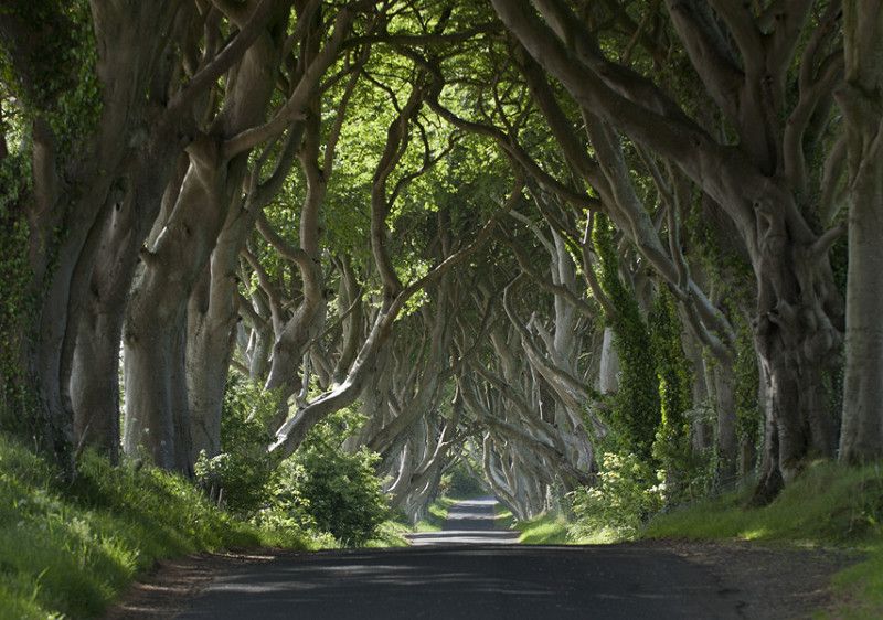
Bregagh Road in County Antrim, Are you a Game of Thrones fan? Then be sure to visit the Dark Hedges. These beech trees were planted in the 18th century by the Stuart family to impress visitors. Past the trees you will find the impressive Georgian house 'Gracehill House'. Two hundred years later it is still an impressive sight. The Dark Hedges are located on Bregagh Road in County Antrim. If you come early in the day you have the best chance of a photo without people!
55° 8' 6.6" N 6° 22' 55" W
55.1351690 -6.3819409
• Head northeast on Ballinlea Road (B147). Go for 6.9 km.
• Continue on B147. Go for 33 m.
• Continue on Ballinlea Road (B147). Go for 367 m.
• Turn right onto Straid Road (B17). Go for 48 m.
• Turn left onto Ballinlea Road (B147). Go for 2.4 km.
• Turn left onto Ballinlea Road (A2). Go for 1.9 km.
• Turn right onto Whitepark Road (B15). Go for 986 m.
• Continue on B15. Go for 22 m.
• Continue on Main Street (B15). Go for 362 m.
• Arrive at Main Street (B15). Your destination is on the left.
☍
13,0 km
( 13 min.)
Ballintoy
Main Street, Ballintoy, County Antrim, Noord-Ierland, Verenigd Koninkrijk
55° 14' 12.4" N 6° 21' 33.6" W
55.2367811 -6.3593257
• Head toward Larrybane Park on Main Street (B15). Go for 362 m.
• Continue on B15. Go for 22 m.
• Continue on Whitepark Road (B15). Go for 11.8 km.
• Take the 1st exit from roundabout onto Main Street. Go for 401 m.
• Continue on B17. Go for 34 m.
• Continue on Hamill Terrace (B17). Go for 144 m.
• Continue on Castlecat Road (B17). Go for 35 m.
• Turn left onto Distillery Road. Go for 96 m.
• Turn left onto Distillery Road. Go for 97 m.
• Arrive at Distillery Road. Your destination is on the left.
☍
13,0 km
( 13 min.)
Bushmills
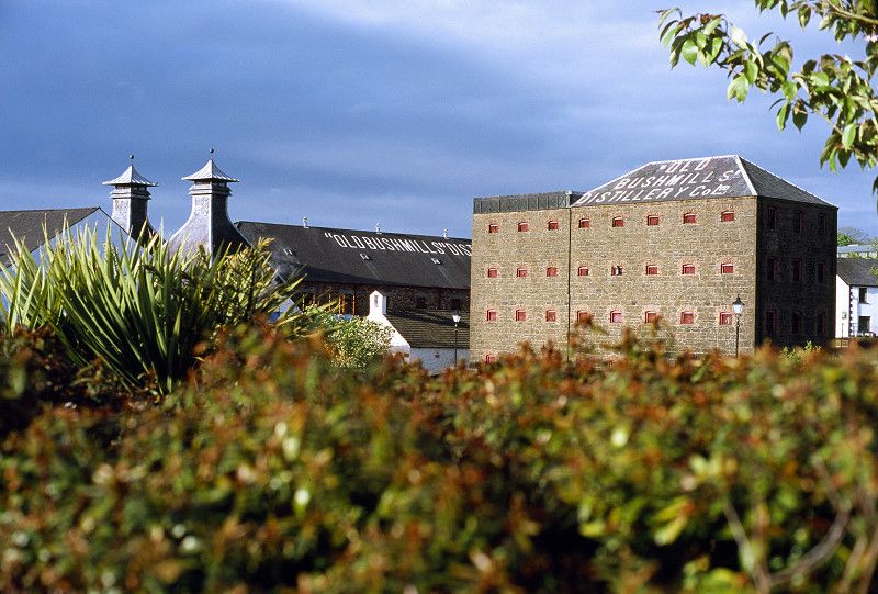
Do you like a good glass of Irish whiskey? Then be sure to visit Old Bushmills Distillery! On the north coast you will find the oldest recognized distillery in the world. Whiskey has been made here since 1608 using Irish barley and unique water from its own stream. The Bushmills Brand Experience includes tours of the working distillery with all the associated smells and tastings. The triple distillation is at the heart of all Bushmills whiskeys and creates a unique combination of richness and smoothness.
Tour Route 2, Bushmills, County Antrim, Noord-Ierland, Verenigd Koninkrijk
55° 12' 6.4" N 6° 31' 14.6" W
55.2017849 -6.5207306
• Head northeast on Distillery Road. Go for 29 m.
• Turn right. Go for 104 m.
• Turn right toward Distillery Road. Go for 33 m.
• Continue on Distillery Road. Go for 96 m.
• Turn right onto Castlecat Road (B17). Go for 35 m.
• Continue on Elmwood Park (B17). Go for 144 m.
• Continue on B17. Go for 34 m.
• Continue on Main Street (B17). Go for 131 m.
• Continue on Main Street. Go for 256 m.
• Take the 1st exit from roundabout onto Dunluce Road (A2). Go for 8.6 km.
• Take the 2nd exit from roundabout onto Causeway Street. Go for 734 m.
• Turn left onto Eglinton Street. Go for 140 m.
• Turn right onto Kerr Street. Go for 528 m.
• Keep right onto Main Street. Go for 129 m.
• Turn right onto Mark Street. Go for 265 m.
• Arrive at Mark Street. Your destination is on the right.
☍
11,3 km
( 15 min.)
Portrush
Mark Street, Portrush, County Antrim, Noord-Ierland, Verenigd Koninkrijk
55° 12' 21.7" N 6° 39' 14.6" W
55.2060325 -6.6540486
• Head toward Eglinton Street on Mark Street. Go for 195 m.
• Turn right onto Eglinton Street. Go for 53 m.
• Turn left onto Dunluce Avenue. Go for 337 m.
• Keep left onto Dunluce Avenue. Go for 224 m.
• Take the 1st exit from roundabout onto Crocknamack Road (A2). Go for 349 m.
• Take the 3rd exit from roundabout onto Bushmills Road (A2). Go for 4.6 km.
• Turn right onto Ballytober Road. Go for 153 m.
• Turn left onto Ballyclogh Road. Go for 274 m.
• Arrive at Ballyclogh Road. Your destination is on the left.
☍
6,2 km
( 8 min.)
Portballintrae
Visit the oldest working whisky distillery on the island, then explore the medieval remains of the seat of the Earls of County Antrim.
Ballyclough Road, Portballintrae, County Antrim, Noord-Ierland, Verenigd Koninkrijk
55° 12' 33.1" N 6° 34' 26.3" W
55.2091952 -6.5739771
• Head toward Ballytober Road on Ballyclogh Road. Go for 274 m.
• Turn right onto Ballytober Road. Go for 153 m.
• Turn left onto Dunluce Road (A2). Go for 4.6 km.
• Take the 1st exit from roundabout onto Crocknamack Road (A2). Go for 357 m.
• Take the 1st exit from roundabout onto Crocknamack Road (A2). Go for 322 m.
• Turn left onto Eglinton Street (A2) toward Portstewart/Coleraine/(A29). Go for 42 m.
• Take the 2nd exit from roundabout onto Portstewart Road (A2). Go for 330 m.
• Take the 3rd exit from roundabout onto Portstewart Road (A2). Go for 5.0 km.
• Arrive at The Promenade (A2). Your destination is on the right.
☍
11,0 km
( 14 min.)
Portstewart
The Diamond, Portstewart, County Londonderry, Noord-Ierland, Verenigd Koninkrijk
55° 10' 58.5" N 6° 43' 7.3" W
55.1829096 -6.7187008
• Head south on The Promenade (A2). Go for 89 m.
• Pass 2 roundabouts and continue on Coleraine Road (A2). Go for 5.8 km.
• Turn right onto Millburn Road (A2). Go for 739 m.
• Turn left onto Union Street. Go for 231 m.
• Turn right onto Brook Street. Go for 658 m.
• Keep right onto Beresford Road. Go for 133 m.
• Turn right onto Blindgate Street. Go for 86 m.
• Turn left onto Bannfield Road. Go for 130 m.
• Continue on Hanover Place. Go for 309 m.
• Keep left onto A2 toward L'Derry/(A37)/Belfast/(A29)/Garvagh/Kilrea/(A54)/Castleknock. Go for 28 m.
• Turn left onto A2. Go for 108 m.
• Turn left onto Strand Road. Go for 50 m.
• Turn right onto Waterside. Go for 65 m.
• Keep right onto Killowen Street. Go for 66 m.
• Turn slightly left onto Castlerock Road (A2). Go for 494 m.
• Pass 2 roundabouts and continue on Castlerock Road (A2). Go for 9.8 km.
• Arrive at Mussenden Road (A2).
☍
18,8 km
( 20 min.)
Castlerock
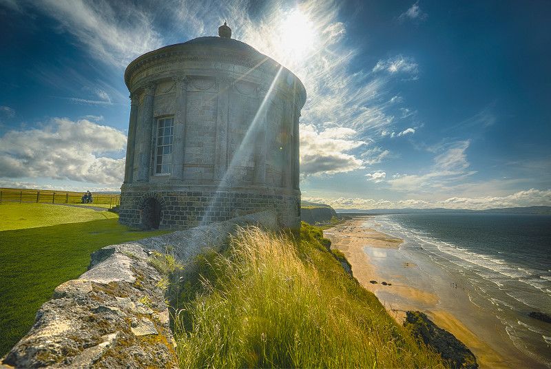
This temple is situated in the beautiful surroundings of Downhill Demesne, near the coastal village of Castlerock. Mussenden Temple was built in 1785 on a cliff 120 feet high above the Atlantic Ocean on the northwest coast. At that time, the temple served as a summer library for the Bishop of Derry and Earl of Bristol. Over the years, the temple was in danger of being lost due to erosion of the cliff. To prevent this, the National Trust carried out cliff stabilisation in 1997 to prevent the loss of this building. Today, the temple and the surrounding views are one of the most photographed locations in Ireland.
Mussenden Road, Castlerock, County Londonderry, Noord-Ierland, Verenigd Koninkrijk
55° 10' 4.6" N 6° 48' 39.1" W
55.1679565 -6.8108539
• Head toward Burrenmore Road on Mussenden Road (A2). Go for 8.7 km.
• Turn right onto Wheatsheaf Road (B201). Go for 641 m.
• Take the 2nd exit from roundabout onto Greenhall Highway (B201). Go for 1.8 km.
• Take the 2nd exit from Greenmount Roundabout roundabout onto Dunhill Road (A29) toward Ring Road/Kilrea/(A54). Go for 525 m.
• Pass 2 roundabouts and continue on Ring Road (A29). Go for 2.1 km.
• Turn right onto Newmills Road. Go for 1.8 km.
• Turn left onto Newmills Road. Go for 292 m.
• Arrive at Newmills Road. Your destination is on the right.
☍
15,9 km
( 14 min.)
64, Newmills Road, County Londonderry, Noord-Ierland, BT52 2JS, Verenigd Koninkrijk
55° 7' 17.6" N 6° 37' 15.4" W
55.1215483 -6.6209505
• Head southwest on Newmills Road. Go for 292 m.
• Turn right onto Newmills Road. Go for 1.8 km.
• Turn left onto Ring Road (A29). Go for 879 m.
• Take the 3rd exit from Lodge Road Roundabout roundabout onto Ring Road (A29) toward Cookstown/Garvagh/Londonderry/Limavady/(A37)/Kilrea/(A54)/Castlerock/(B201)/Killowen/Waterside. Go for 1.2 km.
• Pass 4 roundabouts and continue on Broad Road (A37). Go for 20.5 km.
• Take the 1st exit from Killane Roundabout roundabout onto Ballykelly Road (A2) toward Londonderry/Airport/Limavady. Go for 1.6 km.
• Take the 2nd exit from Lisnakilly Roundabout roundabout onto Ballykelly Road (A2) toward Londonderry/Eglinton/Airport/Ballykelly. Go for 12.9 km.
• Pass 5 roundabouts and continue on Clooney Road (A2). Go for 9.0 km.
• Take the 4th exit from Caw Roundabout roundabout onto Madams Bank Road (A515) toward Letterkenny/Buncrana/(A2)/Moville. Go for 2.3 km.
• Turn left onto Culmore Road (A2). Go for 1.6 km.
• Take the 2nd exit from Pennyburn Roundabout roundabout onto Strand Road (A2). Go for 1.2 km.
• Take the 2nd exit from Queens Quay Roundabout roundabout onto Queens Quay (A2). Go for 559 m.
• Take the 3rd exit from Harbour Square roundabout. Go for 248 m.
• Keep left onto B529. Go for 22 m.
• Turn left onto Strand Road. Go for 55 m.
• Turn left onto Strand Road. Go for 73 m.
• Continue on Waterloo Place. Go for 35 m.
• Arrive at Waterloo Place. Your destination is on the left.
☍
54,3 km
( 44 min.)
Derry/Londonderry
A walled wonder
Climb to the top of the city walls in Derry~Londonderry and see for yourself. History is all around you. The walls you are standing on were built over 400 years ago. Look out over the Bogside area and you will see history literally written on the walls in the famous murals. Traditional Irish music resounds from the cozy pubs, the museums tell stories of times gone by and the locals still celebrate centuries-old festivals.
View the city from the Peace Bridge
Waterloo Place 16, Derry/Londonderry, County Londonderry, Noord-Ierland, Verenigd Koninkrijk
54° 59' 52.3" N 7° 19' 16.7" W
54.9978678 -7.3213056
• Head toward Waterloo Street on Waterloo Place. Go for 25 m.
• Turn right onto William Street. Go for 160 m.
• Take the 3rd exit from roundabout onto Little James Street. Go for 170 m.
• Turn right onto Great James Street (B529). Go for 88 m.
• Continue on B529. Go for 98 m.
• Continue toward Queens Quay/A2. Go for 38 m.
• Take the 1st exit from Harbour Square roundabout onto Queens Quay (A2). Go for 537 m.
• Pass 2 roundabouts and continue on Culmore Road (A2). Go for 2.6 km.
• Take the 3rd exit from Culmore Road Roundabout roundabout onto Madams Bank Road (A515). Go for 2.5 km.
• Take the 1st exit from Caw Roundabout roundabout onto Clooney Road (A2) toward Coleraine/Limavady/Airport/Lisahally. Go for 413 m.
• Pass 6 roundabouts and continue on Ballykelly Road (A2). Go for 23.0 km.
• Take the 2nd exit from Killane Roundabout roundabout onto Broad Road (A37) toward Coleraine/Ballymoney. Go for 1.3 km.
• Pass 2 roundabouts and continue on Dunhill Road (A29). Go for 18.7 km.
• Take the 3rd exit from Greenmount Roundabout roundabout onto Dunhill Road (A29) toward Ring Road/Kilrea/(A54). Go for 551 m.
• Take the 2nd exit from Strand Road Roundabout roundabout onto Ring Road (A29) toward Ballymena/(A26)/Belfast/(M2)/Portrush. Go for 1.0 km.
• Take the 1st exit from Lodge Road Roundabout roundabout onto Lodge Road (A26). Go for 470 m.
• Continue on Nursery Avenue. Go for 593 m.
• Keep right onto Nursery Avenue toward Town Centre. Go for 104 m.
• Continue on Blindgate Street. Go for 86 m.
• Keep right onto Dunmore Street. Go for 25 m.
• Turn slightly right onto Dunmore Street. Go for 44 m.
• Continue on New Row. Go for 18 m.
• Keep left onto New Row. Go for 74 m.
• Turn slightly left onto New Row West. Go for 86 m.
• Continue on Stable Lane. Go for 89 m.
• Arrive at Stable Lane. Your destination is on the right.
☍
52,8 km
( 44 min.)
Coleraine
The Diamond, Coleraine, County Londonderry, Noord-Ierland, Verenigd Koninkrijk
55° 7' 53.7" N 6° 40' 18.7" W
55.1315912 -6.6718610
• Head southwest on Stable Lane.
• Continue on Abbey Street. Go for 61 m.
• Turn left onto Dunmore Street. Go for 155 m.
• Turn slightly right onto New Row. Go for 101 m.
• Turn right onto Blindgate Street. Go for 54 m.
• Turn left onto Bannfield Road. Go for 130 m.
• Continue on Hanover Place. Go for 309 m.
• Keep right onto Circular Road (A2) toward Portrush/Portstewart/Bushmills/Ballycastle. Go for 366 m.
• Keep right onto Union Street. Go for 439 m.
• Continue on Union Street. Go for 29 m.
• Turn left onto Railway Road (B17). Go for 39 m.
• Continue on Bushmills Road (B17). Go for 892 m.
• Continue on Cloyfin Road (B17). Go for 614 m.
• Take the 2nd exit from Bushmills Road Roundabout roundabout onto Cloyfin Road (B17). Go for 5.7 km.
• Turn right onto Ballybogy Road (B62). Go for 72 m.
• Turn left onto Priestland Road (B17). Go for 4.9 km.
• Turn right onto Bridge Street (B17). Go for 191 m.
• Turn left onto Main Street. Go for 256 m.
• Take the 2nd exit from roundabout onto Whitepark Road (A2). Go for 10.8 km.
• Continue on Whitepark Road (B15). Go for 986 m.
• Continue on B15. Go for 22 m.
• Continue on Main Street (B15). Go for 680 m.
• Continue on B15. Go for 194 m.
• Continue on Whitepark Road (B15). Go for 1.4 km.
• Arrive at Whitepark Road (B15).
☍
28,4 km
( 27 min.)
Carrick-a-rede Rope Bridge, County Antrim, Noord-Ierland, Verenigd Koninkrijk
55° 14' 22.6" N 6° 19' 56.7" W
55.2396127 -6.3324200
• Head toward Glenstaughey Road on Whitepark Road (B15). Go for 1.4 km.
• Continue on B15. Go for 194 m.
• Continue on Main Street (B15). Go for 680 m.
• Continue on B15. Go for 22 m.
• Continue on Whitepark Road (B15). Go for 11.8 km.
• Take the 2nd exit from roundabout onto Dunluce Road (A2). Go for 290 m.
• Turn left onto Priestland Road (B17). Go for 5.2 km.
• Turn right onto Ballybogy Road (B62). Go for 72 m.
• Turn left onto Cloyfin Road (B17). Go for 5.6 km.
• Take the 1st exit from Bushmills Road Roundabout roundabout onto Ring Road (A29). Go for 1.3 km.
• Take the 2nd exit from Ballycastle Road Roundabout roundabout onto Ring Road (A29). Go for 1.4 km.
• Take the 3rd exit from Lodge Road Roundabout roundabout onto Ring Road (A29) toward Cookstown/Garvagh/Londonderry/Limavady/(A37)/Kilrea/(A54)/Castlerock/(B201)/Killowen/Waterside. Go for 1.2 km.
• Pass 4 roundabouts and continue on Broad Road (A37). Go for 19.7 km.
• Turn left toward Limavady Park & Share. Go for 57 m.
• Continue on Rathmore Road (A371). Go for 497 m.
• Pass 3 roundabouts and continue on Main Street (A371). Go for 704 m.
• Turn left onto Connell Street (A371). Go for 480 m.
• Keep right onto Irish Green Street (A371) toward Londonderry/(A2)/Town Centre. Go for 126 m.
• Arrive at Irish Green Street (A371). Your destination is on the right.
☍
50,7 km
( 42 min.)
Limavady
Stay at Carrowmena Activity Centra in Limavady, a glamping site with 15 pitches available. This costs around £24 per night. You will be sleeping close to the beautiful Roe Valley Country Park, which is a great destination for walkers.
Catherine Street, Limavady, County Londonderry, Noord-Ierland, Verenigd Koninkrijk
55° 3' 1.7" N 6° 57' 1.8" W
55.0504857 -6.9505134
• Head northwest on Irish Green Street (A371). Go for 127 m.
• Keep left onto Catherine Street (A371) toward Londonderry. Go for 484 m.
• Turn left onto Clooney Road (B69). Go for 40 m.
• Continue on Baranailt Road (B69). Go for 21.0 km.
• Continue on Church Street (B49). Go for 473 m.
• Turn right onto Cumber Road (B49). Go for 4.6 km.
• Continue on Longland Road (B49). Go for 6.1 km.
• Continue on Berryhill Road (B49). Go for 1.0 km.
• Continue on Longland Road (B49). Go for 882 m.
• Continue on Berryhill Road (B49). Go for 9.0 km.
• Continue on Woodend Road (B49). Go for 1.7 km.
• Turn left onto Victoria Road (A5) toward Omagh/Lifford/(A38). Go for 1.8 km.
• Turn left onto Railway Street. Go for 153 m.
• Take the 2nd exit from roundabout. Go for 63 m.
• Turn right. Go for 27 m.
• Arrive at your destination on the left.
☍
47,4 km
( 39 min.)
Strabane
Railway Street, Strabane, County Tyrone, Noord-Ierland, Verenigd Koninkrijk
54° 49' 44" N 7° 28' 9.2" W
54.8289026 -7.4692192
• Head toward Branch Road. Go for 52 m.
• Turn right toward Branch Road. Go for 27 m.
• Take the 1st exit from roundabout onto Railway Street. Go for 101 m.
• Take the 2nd exit from roundabout onto Lifford Road (A38) toward Lifford. Go for 746 m.
• Continue on N15. Go for 181 m.
• Take the 1st exit from roundabout onto Townparks (N15) toward Sligeach/Sligo. Go for 48.1 km.
• Take the 2nd exit from Drumlonagher Roundabout roundabout toward Dún na nGall (Thuaidh)/Donegal (North). Go for 131 m.
• Continue on Ballybofey Road (R267). Go for 684 m.
• Continue on Main Street (R267). Go for 198 m.
• Continue on Upper Main Street (R267). Go for 542 m.
• Turn right onto Water Street. Go for 111 m.
• Turn left onto New Row. Go for 228 m.
• Turn right onto The Mullins. Go for 40 m.
• Arrive at The Mullins. Your destination is on the right.
☍
51,1 km
( 40 min.)
Tirconnel Street, County Donegal, Ierland
54° 39' 22.3" N 8° 6' 37.6" W
54.6561985 -8.1104460
• Head toward New Row on The Mullins. Go for 40 m.
• Turn right onto Waterloo Place. Go for 96 m.
• Turn left onto Waterloo Place. Go for 46 m.
• Turn left toward Bridge Street. Go for 49 m.
• Continue on Bridge Street. Go for 94 m.
• Continue on The Diamond (R267). Go for 76 m.
• Turn right onto The Diamond (R267). Go for 66 m.
• Turn left onto Quay Street (R267). Go for 313 m.
• Continue on The Glebe (R267). Go for 352 m.
• Continue on R267. Go for 479 m.
• Continue on Ardchicken (R267). Go for 18 m.
• Continue on Tullaghcullion (R267). Go for 140 m.
• Continue on Ardchicken (R267). Go for 204 m.
• Continue on Lurganboy (R267). Go for 58 m.
• Continue on Ardchicken (R267). Go for 72 m.
• Continue on Lurganboy (R267). Go for 636 m.
• Continue on Ardlenagh (R267). Go for 215 m.
• Continue on Lurganboy (R267). Go for 228 m.
• Continue on Drumgowan (R267). Go for 774 m.
• Continue on Tullyearl (R267). Go for 285 m.
• Take the 2nd exit from Tullyearl Roundabout roundabout onto Tullygallan (N15) toward Sligeach/Sligo/Béal Átha Seanaidh/Ballyshannon. Go for 2.1 km.
• Turn left onto R232 toward (R232)/Paiteagó/Pettigo/An Lathaigh/Laghey. Go for 20.9 km.
• Turn right onto The Diamond (R232). Go for 91 m.
• Continue on A35. Go for 8.5 km.
• Take the 1st exit from roundabout onto Main Street (A35) toward Ederney/Omagh/(A32). Go for 140 m.
• Take the 1st exit from roundabout onto Station Road (B4) toward Ederney/Omagh/(A32). Go for 198 m.
• Continue on Letterboy Road (B4). Go for 4.2 km.
• Take the 2nd exit from roundabout onto Market Street (B4). Go for 16.7 km.
• Turn left onto Clanabogan Road (A32). Go for 9.2 km.
• Turn left onto A32 toward Dublin/Strabane/(A5)/Belfast/(A4)/Cookstown/(A505). Go for 73 m.
• Turn sharp left onto Great Northern Road (A5) toward Dublin/Belfast/Dungannon/Cookstown/(A505). Go for 643 m.
• Turn left onto Kevlin Avenue. Go for 59 m.
• Turn left onto Kevlin Road. Go for 112 m.
• Turn right onto Sunningdale. Go for 82 m.
• Turn left onto Sunningdale. Go for 171 m.
• Keep left onto Sunningdale. Go for 83 m.
• Arrive at Sunningdale. Your destination is on the left.
☍
67,5 km
( 53 min.)
Omagh
Ashley Gardens, Omagh, County Tyrone, Noord-Ierland, Verenigd Koninkrijk
54° 35' 39.6" N 7° 18' 13.1" W
54.5943217 -7.3036385
• Head north on Sunningdale. Go for 248 m.
• Turn right onto Sunningdale. Go for 101 m.
• Turn left onto Kevlin Road. Go for 57 m.
• Turn left onto Kevlin Road. Go for 352 m.
• Turn left onto John Street. Go for 70 m.
• Turn left onto James Street (A32). Go for 178 m.
• Continue on Dromore Road (A32). Go for 13.8 km.
• Turn left onto Old Creamery Road (A32) toward Irvinestown/Enniskillen/Fintona/Trillick/(B46). Go for 160 m.
• Take the 2nd exit from roundabout onto A32 toward Irvinestown/Enniskillen. Go for 13.0 km.
• Take the 1st exit from roundabout onto Brownhill Link (A32) toward Enniskillen. Go for 274 m.
• Take the 1st exit from roundabout onto Mill Street (A32) toward Enniskillen. Go for 9.9 km.
• Pass 2 roundabouts and continue on Irvinestown Road (A32). Go for 3.2 km.
• Take the 3rd exit from Cherrymount Roundabout roundabout onto Cornagrade Road (A32) toward Donegal/Sligo/(A4)/Dublin/(A509). Go for 1.6 km.
• Take the 1st exit from roundabout onto Queen Elizabeth Road (A4) toward Belfast. Go for 600 m.
• Turn right onto East Bridge Street (A4). Go for 196 m.
• Continue on Townhall Street. Go for 140 m.
• Continue on High Street. Go for 4 m.
• Arrive at High Street.
☍
43,8 km
( 36 min.)
Enniskillen
Marble Arch Caves (Open Year-Round) Marble Arch Caves Global Geopark
This nature park is home to some of the most beautiful scenery in the north of Ireland. It ranges from rugged highlands, forests and lakes to gently rolling drumlins. The landscapes of the Geopark represent a complex geological history dating back 650 million years. The Marble Arch Caves are one of the finest show caves in Europe. The caves offer a fascinating natural underworld of rivers, waterfalls, winding passages and chambers, while stunningly beautiful cave formations glitter all around. A true spectacle to walk through.
The Diamond, Enniskillen, Noord-Ierland, Verenigd Koninkrijk
54° 20' 41.5" N 7° 38' 20.2" W
54.3448538 -7.6389365
• Head northwest on High Street. Go for 82 m.
• Turn left onto Paget Square. Go for 109 m.
• Turn left onto Wellington Road (A4). Go for 692 m.
• Turn right onto Dublin Road (A4) toward Belfast. Go for 198 m.
• Keep right onto Dublin Road (A4) toward Belfast/Maguiresbridge/Lisnaskea/(A34). Go for 27.1 km.
• Take the 1st exit from roundabout onto Clabby Road (B107) toward Clogher/Belfast/A4/Clabby/Fintona/(B122). Go for 47 m.
• Continue toward Clogher/A4/Belfast/(M1). Go for 29 m.
• Continue on Edfield Way. Go for 312 m.
• Take the 2nd exit from roundabout onto Murley Road (B122) toward Clogher/A4/Belfast/(M1)/Dungannon. Go for 83 m.
• Take the 1st exit from roundabout onto Ballagh Road (A4) toward Belfast. Go for 13.5 km.
• Take the 2nd exit from roundabout onto Annaghilla Road (A4) toward Dungannon/Belfast. Go for 7.3 km.
• Take the 3rd exit from New Ballygawley Roundabout roundabout onto Tullyvar Road (A5) toward Aughnacloy/Dublin/(N2)/Armagh/(A28). Go for 6.2 km.
• Continue on Moore Street (A28) toward Armagh. Go for 12.0 km.
• Turn right onto Main Street (A28) toward Armagh/Middletown/(B120). Go for 11.5 km.
• Turn left onto Ballycrummy Road. Go for 925 m.
• Turn right onto Cathedral Road (B115). Go for 1.6 km.
• Turn left onto College Street (B115). Go for 115 m.
• Arrive at College Street (B115). Your destination is on the left.
☍
81,8 km
(1 hrs. )
Armagh
Lonsdale Road, Armagh, County Armagh, Noord-Ierland, Verenigd Koninkrijk
54° 21' 1.2" N 6° 39' 12.8" W
54.3503408 -6.6535495
• Head toward College Hill on College Street (B115). Go for 31 m.
• Turn right onto The Mall West (A3). Go for 486 m.
• Turn sharp right onto Barrack Street (A3). Go for 556 m.
• Keep left onto A3 toward Monaghan/Keady/(A29)/Newtownhamilton. Go for 248 m.
• Turn left onto Irish Street (A3) toward Monaghan/Keady/(A29)/N'hamilton/(B31). Go for 464 m.
• Turn right onto Monaghan Road (A3) toward Milford. Go for 17.6 km.
• Continue on Tamlat (N12). Go for 6.1 km.
• Take the 2nd exit from roundabout onto Armagh Road (N12). Go for 741 m.
• Take the 2nd exit from Coolshannagh Roundabout roundabout onto Coolshannagh (N54) toward Muineachán/Town Centre. Go for 2.0 km.
• Take the 3rd exit from roundabout onto Broad Road (N54) toward An Cabhán/Cavan. Go for 438 m.
• Continue on Market Road (N54) toward An Cabhán/Cavan. Go for 185 m.
• Take the 2nd exit from roundabout onto Clones Road (N54) toward An Cabhán/Cavan. Go for 20.6 km.
• Continue on Cavan Road (A3). Go for 3.5 km.
• Continue on Clonnagore (N54). Go for 3.6 km.
• Continue on Cavan Road (A3). Go for 3.2 km.
• Continue on Leggykelly (N54). Go for 8.9 km.
• Take the 2nd exit from roundabout onto Tullybuck (N54) toward Dublin/Ballyshannon. Go for 214 m.
• Turn left onto Drummany (N3) toward Áth Cliath/Dublin/B. Átha Luain/Athlone/(N55)/An Cabhán/Cavan. Go for 7.8 km.
• Take the 2nd exit from Dublin Road Roundabout roundabout onto N55 toward Baile Átha Luain/Athlone/Béal Átha na nEach/Ballinagh/Cill na Seanrátha/Killashandra. Go for 2.5 km.
• Take the 2nd exit from roundabout onto Moynehall (N55) toward Athlone/Gránard/Granard/Cill na Seanrátha/Killashandra/(R154)/Ármhach/Arvagh. Go for 5.2 km.
• Turn left onto Main Street (N55) toward B. Átha Luain/Athlone/Granard/Gránard/An tSeanchaisleán/Oldcastle/R154/B.Shéamais Dhuibh/Ballyjamesduff/(R194)/Cill na Leice/Kilnaleck. Go for 22 m.
• Turn right onto Main Street (N55). Go for 1.1 km.
• Take the 2nd exit from roundabout onto Garrymore (N55) toward Baile Átha Luain/Athlone/Gránard/Granard/Loch Gamhna/Lough Gowna. Go for 31.0 km.
• Turn left onto Dublin Road (N55) toward (N4)/Baile átha Luain/Athlone/Áth Cliath/Dublin/Sligeach/Sligo/An Longfort/Longford. Go for 326 m.
• Take the 2nd exit from roundabout onto N4 toward Sligeach/Sligo/An Longfort/Longford/(N55)/Athlone. Go for 510 m.
• Take the 1st exit from Goldsmiths Roundabout roundabout onto Ballymahon Road (N55) toward Athlone. Go for 18.5 km.
• Turn left onto Main Street (N55) toward B. Átha Luain/Athlone/Glasán/Glasson/An Muileann gCearr/Mullingar/(R392). Go for 355 m.
• Turn right onto Athlone Road (N55) toward B. Átha Luain/Athlone/Glasán/Glasson. Go for 18.0 km.
• Take the 1st exit from roundabout onto Cornamaddy (R916) toward Bladhraí Industrial Estate/Blyry Industrial Estate/Átha Cliath/Dublin/(N6)/Biorra/Birr/(N62). Go for 1.2 km.
• Turn right and take ramp onto N6 toward Gaillimh/Galway/Ros Comáin/Roscommon. Go for 5.9 km.
• Keep right onto M6 toward Gaillimh/Galway. Go for 72.3 km.
• Continue on N6. Go for 3.7 km.
• Take the 2nd exit from Coolagh Roundabout roundabout onto Bothar na Dtreabh (N6) toward Galway City (West)/(N59)/An Clochán/Clifden/(N84)/Cais. an Bharraigh/Castlebar. Go for 3.2 km.
• Turn left onto Tuam Road (R336) toward An Lár/City Centre. Go for 1.6 km.
• Take the 2nd exit from Joyce Roundabout roundabout onto Bohermore (R336). Go for 938 m.
• Turn left onto Bóthar Bhreandain Uí Eithir. Go for 130 m.
• Turn left onto Forster Court. Go for 73 m.
• Turn slightly right onto Forster Court. Go for 397 m.
• Arrive at Forster Court. Your destination is on the right.
☍
243,6 km
(2 hrs. 53 min.)
Galway (stad)
Forster Court, Galway (stad), County Galway, Ierland
53° 16' 44.2" N 9° 2' 35.8" W
53.2789405 -9.0432745
• Head east on Forster Court. Go for 397 m.
• Turn slightly left onto Forster Court. Go for 73 m.
• Turn left onto Bóthar Bhreandain Uí Eithir. Go for 68 m.
• Turn sharp left onto Forster Street (R339). Go for 1.2 km.
• Turn right onto Dublin Road (R338). Go for 1.8 km.
• Take the 2nd exit from Skerritt Roundabout roundabout onto Dublin Road (R338). Go for 2.6 km.
• Turn right onto R446. Go for 3.1 km.
• Take the 2nd exit from roundabout onto N18 toward Luimneach/Limerick/(N19)/(R446)/Creachmhaoil/Craughwell. Go for 910 m.
• Take the 2nd exit from roundabout onto N18 toward Luimneach/Limerick/An Gort/Gort/Droichead an Chláirín/Clarinbridge. Go for 1.3 km.
• Take the 1st exit from roundabout onto Rocklands (N18) toward Luimneach/Limerick/An Gort/Gort. Go for 7.3 km.
• Continue on N18 toward Luimneach/Limerick. Go for 3.8 km.
• Take the 2nd exit from roundabout onto Kiltiernan (N18) toward Luimneach/Limerick/(M18)/An Gort/Gort/Ard Raithin/Ardrahan/R458. Go for 463 m.
• Take the 2nd exit from roundabout onto M18 toward Luimneach/Limerick/Aerfort na Sionainne/Shannon Airport/(N19). Go for 55.1 km.
• Continue on N18. Go for 12.5 km.
• Take ramp toward Luimneach(an Lár)/Limerick(Centre)/Cathair Dhaibhin/Caherdavin/R445. Go for 580 m.
• Pass 2 roundabouts and continue on R445. Go for 2.2 km.
• Take the 2nd exit from Clondrinagh Roundabout roundabout onto Ennis Road toward Luimneach/Limerick/N7/N20/N21/N24/N69. Go for 556 m.
• Take the 2nd exit from Coonagh Roundabout roundabout onto Ennis Road (N7). Go for 980 m.
• Continue on Ennis Road (R857). Go for 415 m.
• Turn left onto Corrib Drive. Go for 240 m.
• Turn left onto Merval Drive. Go for 81 m.
• Turn right onto Brookville Avenue. Go for 321 m.
• Arrive at Brookville Avenue. Your destination is on the right.
☍
96,0 km
(1 hrs. 8 min.)
Limerick
Brookville Avenue 27, Limerick, County Limerick, Ierland
52° 40' 22.4" N 8° 39' 6.7" W
52.6728780 -8.6518510
• Head east on Brookville Avenue. Go for 75 m.
• Turn right onto Lissadell Drive. Go for 80 m.
• Turn left onto Merval Drive. Go for 248 m.
• Turn left onto Mayorstone Upper. Go for 88 m.
• Turn left onto Cratloe Road (N7). Go for 52 m.
• Take the 1st exit from Moylish Roundabout roundabout onto N7. Go for 1.0 km.
• Continue on Clonmacken Road (R857). Go for 301 m.
• Take the 3rd exit from roundabout onto Clonmacken Road (R857). Go for 571 m.
• Take the 3rd exit from Clonmacken Roundabout roundabout. Go for 1.6 km.
• Take ramp onto N18. Go for 5.4 km.
• Continue on M7. Go for 80.8 km.
• Take exit 21 toward Maighean Rátha/Mountrath/Buiríos Mór Osraí/Borris-in-Ossory/Ráth Domhnaigh/Rathdowney/Main. Laoise/Abbeyleix. Go for 507 m.
• Take the 1st exit from roundabout onto R435. Go for 929 m.
• Take the 2nd exit from roundabout onto R435. Go for 1.3 km.
• Take the 2nd exit from roundabout onto Roscrea Road (R445). Go for 3.1 km.
• Turn right onto Sentry Hill (R434). Go for 747 m.
• Continue on Ballytarsna (R434). Go for 170 m.
• Continue on Sentry Hill (R434). Go for 940 m.
• Continue on Knockaroe (R434). Go for 496 m.
• Continue on Kilbeg (R434). Go for 719 m.
• Continue on Derrinoliver (R434). Go for 300 m.
• Continue on Lowran (R434). Go for 477 m.
• Continue on Carrowreagh (R434). Go for 749 m.
• Continue on Keelough Glebe (R434). Go for 744 m.
• Continue on Aghaboe (R434). Go for 609 m.
• Continue on Corraun (R434). Go for 393 m.
• Continue on Aghaboe (R434). Go for 78 m.
• Continue on Corraun (R434). Go for 66 m.
• Continue on Aghaboe (R434). Go for 908 m.
• Continue on Cross (R434). Go for 331 m.
• Continue on Friarsland (R434). Go for 97 m.
• Continue on Coolfin (R434). Go for 476 m.
• Continue on Springfield (R434). Go for 269 m.
• Continue on Boherard (R434). Go for 335 m.
• Continue on Springfield (R434). Go for 1.4 km.
• Continue on Kilminfoyle (R434). Go for 1.4 km.
• Continue on R434. Go for 433 m.
• Continue on Clough Road (R434). Go for 1.1 km.
• Continue on Durrow Road (R434). Go for 156 m.
• Continue on R434. Go for 195 m.
• Continue on Cool (R434). Go for 819 m.
• Continue on Coolderry (R434). Go for 1.2 km.
• Continue on Moyne (R434). Go for 1.7 km.
• Continue on Swan (R434). Go for 332 m.
• Continue on R434. Go for 40 m.
• Continue on Swan Road (R434). Go for 1.2 km.
• Turn right onto N77. Go for 164 m.
• Turn left onto The Square (N77) toward Cill Chainnigh/Kilkenny/Béal Átha Ragad/Ballyragget. Go for 19.3 km.
• Take the 2nd exit from roundabout onto N77 toward Cill Chainnigh/Kilkenny. Go for 3.7 km.
• Take the 2nd exit from roundabout onto Dunmore (N77) toward An Lár/CITY CENTRE. Go for 2.0 km.
• Take the 3rd exit from New Road Roundabout roundabout onto Castlecomer Road (N77). Go for 509 m.
• Take the 3rd exit from roundabout onto Castlecomer New Road (N77). Go for 179 m.
• Continue on John Street Upper. Go for 161 m.
• Continue on John Street. Go for 7 m.
• Continue on John Street Lower. Go for 222 m.
• Continue on John's Bridge. Go for 71 m.
• Continue on Rose Inn Street. Go for 144 m.
• Turn right onto High Street. Go for 243 m.
• Turn left onto Chapel Lane. Go for 30 m.
• Arrive at Chapel Lane. Your destination is on the right.
☍
141,6 km
(1 hrs. 44 min.)
Kilkenny
James's Street, Kilkenny, County Kilkenny, Ierland
52° 39' 9.1" N 7° 15' 14.1" W
52.6525294 -7.2539101
• Head toward Wellington Square on Chapel Lane. Go for 68 m.
• Turn left onto Chapel Lane. Go for 24 m.
• Turn right onto Collier's Lane. Go for 49 m.
• Turn left onto Garden Row. Go for 139 m.
• Turn right onto Friary Street. Go for 121 m.
• Turn left onto Walkin Street. Go for 7 m.
• Turn left onto Lower New Street. Go for 340 m.
• Turn right onto College Road. Go for 631 m.
• Continue on Callan Road. Go for 40 m.
• Take the 2nd exit from College Road Roundabout roundabout onto Callan Road. Go for 228 m.
• Take the 1st exit from roundabout onto N76 toward (M9)/(N10)/Áth Cliath/Dublin/Port Láirge/Waterford/(N77)/Darú/Durrow. Go for 656 m.
• Take the 2nd exit from roundabout onto N76 toward (M9)/(N10)/Áth Cliath/Dublin/Port Láirge/Waterford/(N77)/Darú/Durrow/(R910)/An Lár/City Centre. Go for 500 m.
• Take the 3rd exit from Waterford Road Roundabout roundabout onto Ring Road (N10) toward Port Láirge/Waterford/(M9). Go for 680 m.
• Pass 2 roundabouts and continue on N10. Go for 6.7 km.
• Take the 2nd exit from roundabout onto M9 toward Port Láirge/Waterford. Go for 35.1 km.
• Take the 1st exit from Quarry Roundabout roundabout onto N9 toward Port Láirge/WATERFORD/(N25)/Corcaigh/Cork/Ros Láir/Rosslare. Go for 565 m.
• Take the 2nd exit from Grannagh Junction Roundabout roundabout onto R861 toward An Lár/CITY CENTRE/R448. Go for 1.2 km.
• Take the 2nd exit from Newrath Roundabout roundabout onto R448. Go for 2.0 km.
• Take the 2nd exit from roundabout onto Dock Road (R711). Go for 566 m.
• Turn right. Go for 54 m.
• Arrive at your destination.
☍
49,7 km
( 36 min.)
Waterford
Dock Road, Waterford, County Waterford, Ierland
52° 15' 50.8" N 7° 6' 30.7" W
52.2641031 -7.1085242
• Head toward Dock Road. Go for 40 m.
• Turn right onto Dock Road (R711). Go for 1.1 km.
• Pass 2 roundabouts and continue on Belmount Road (R711). Go for 2.9 km.
• Take the 2nd exit from Slieverue Roundabout roundabout onto Rathpatrick (N29). Go for 743 m.
• Take the 2nd exit from Luffany Roundabout roundabout onto Rathpatrick (N25) toward Ros Láir/Rosslare/Ros Mhic Thriúin/New Ross. Go for 9.6 km.
• Take the 3rd exit from roundabout onto N25 toward Ros Láir/Rosslare/Loch Garman/Wexford. Go for 8.8 km.
• Take the 3rd exit from roundabout onto Ballymacar (N25) toward Ros Láir/Rosslare/Loch Garman/Wexford. Go for 27.9 km.
• Take the 3rd exit from New Ross Road Roundabout roundabout onto Belmont (N25) toward Ros Láir/Rosslare. Go for 2.0 km.
• Take the 2nd exit from Duncannon Road Roundabout roundabout onto Clonard Great (N25) toward Ros Láir/Rosslare. Go for 3.9 km.
• Take the 2nd exit from Rosslare Road Roundabout roundabout onto Blackhorse (N25) toward Ros Láir/Rosslare. Go for 7.0 km.
• Take the 2nd exit from roundabout onto Ballybrennan Big (N25) toward Rosslare Harbour. Go for 3.2 km.
• Turn right onto Ballycowan (R736). Go for 720 m.
• Turn left onto Ballycowan. Go for 103 m.
• Continue on Ballykelsh. Go for 301 m.
• Turn right onto Hillcastle. Go for 611 m.
• Continue on Lough. Go for 523 m.
• Turn left onto Lough. Go for 241 m.
• Continue on Glaglig. Go for 177 m.
• Continue on Allenstown Little. Go for 244 m.
• Continue on Allenstown Big. Go for 288 m.
• Arrive at Allenstown Big. Your destination is on the left.
☍
70,4 km
( 56 min.)
L3064, County Wexford, Ierland
52° 13' 22.9" N 6° 23' 34" W
52.2230166 -6.3927784