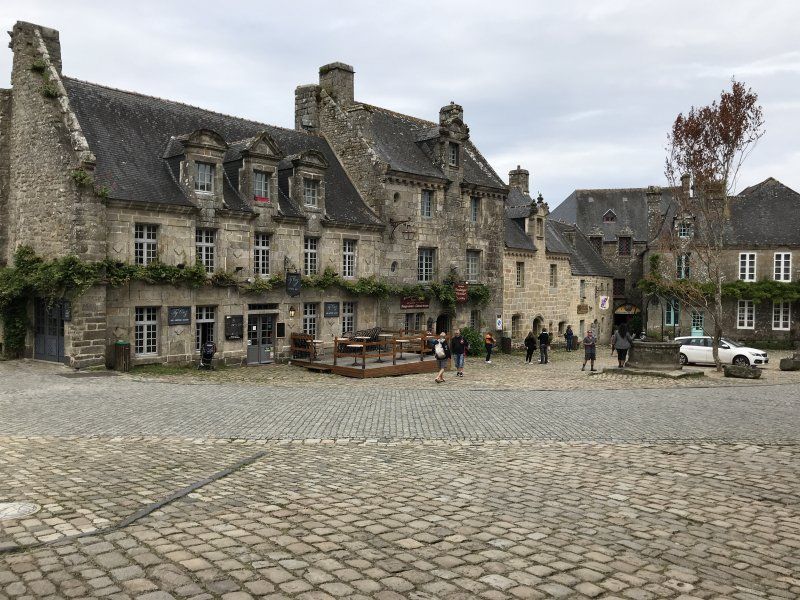
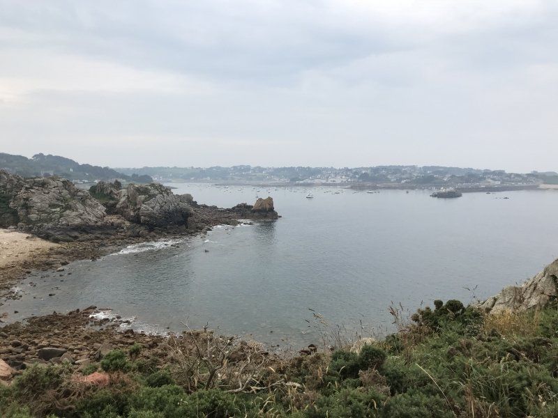
Many years ago we were last in Brittany. There were still a lot of white spots on the map and in 2018 our plan was to see more of Brittany. Some already visited sights such as For example, we have not started Carnac. In France we only drove on toll-free roads. Conclusion: We found the northern granite rose coast as a highlight. This is probably why many circular tours start counter-clockwise in St. Malo. We drove clockwise and found it more exciting. Next year we will visit Brittany and the Loire Valley again and hope for a summer like this year.
Day
Bad Vilbel, Deutschland
Parkstraße 18, 61118 Bad Vilbel, Deutschland
50° 10' 56.4" N 8° 44' 22.1" E
50.1823356 8.7394805
• Head southwest on Parkstraße. Go for 30 m.
• Take the 1st exit from roundabout onto Niddastraße. Go for 206 m.
• Turn right onto Kasseler Straße. Go for 89 m.
• Take the 2nd exit from roundabout onto Homburger Straße. Go for 94 m.
• Pass 2 roundabouts and continue on Homburger Straße. Go for 895 m.
• Take the 1st exit from roundabout onto B3 toward A661/Frankfurt. Go for 4.3 km.
• Take the left exit toward Würzburg/Offenbach/Frankfurt-Ost onto A661. Go for 11.4 km.
• Take exit 17 toward Köln/Wiesbaden/F. Kreuz/Flughafen onto A3. Go for 17.6 km.
• Take exit 48 toward Darmstadt/Mainz/Rüsselsheim onto A67. Go for 6.3 km.
• Take exit 3 toward Mainz/Wiesbaden/Rüsselsheim/Rüdesheim onto A60. Go for 17.6 km.
• Take exit 21 toward Kaiserslautern/Ludwigshafen/Alzey onto A63. Go for 70.5 km.
• Continue on Dreieck Kaiserslautern. Go for 343 m.
• Continue on A6. Go for 72.1 km.
• Continue on A320. Go for 13.5 km.
• Continue on E50 (Échangeur de Freyming). Go for 259 m.
• Take the left exit toward Paris/Metz/St Avold/Carling onto A4 (Autoroute de l'Est). Go for 41.6 km.
• Keep left onto A314 toward Metz/Nancy. Go for 1.5 km.
• Take the left exit toward Nancy/Aéroport Régional/Technopole/Actipole onto A315. Go for 1.2 km.
• Continue on N431. Go for 14.5 km.
• Take the 2nd exit from roundabout toward Nancy/Pagny S/M./Fey. Go for 178 m.
• Take the 2nd exit from roundabout onto A31 toward Nancy. Go for 11.2 km.
• Take exit 28 toward Pont-à-Mousson/Aéroport Régional/Pont à M./Lesménils. Go for 387 m.
• Continue on Route Nationale (D910). Go for 379 m.
• Take the 2nd exit from roundabout onto Route Nationale (D910) toward Verdun/Pont à Mousson. Go for 4.0 km.
• Turn left onto Avenue de Metz (D657) toward Pont à Mousson-Centre. Go for 1.2 km.
• Continue on Avenue des États-Unis (D120). Go for 341 m.
• Turn right onto Boulevard du Maréchal de Lattre de Tassigny. Go for 86 m.
• Arrive at Boulevard du Maréchal de Lattre de Tassigny. Your destination is on the left.
☍
291,9 km
(2 hrs. 45 min.)
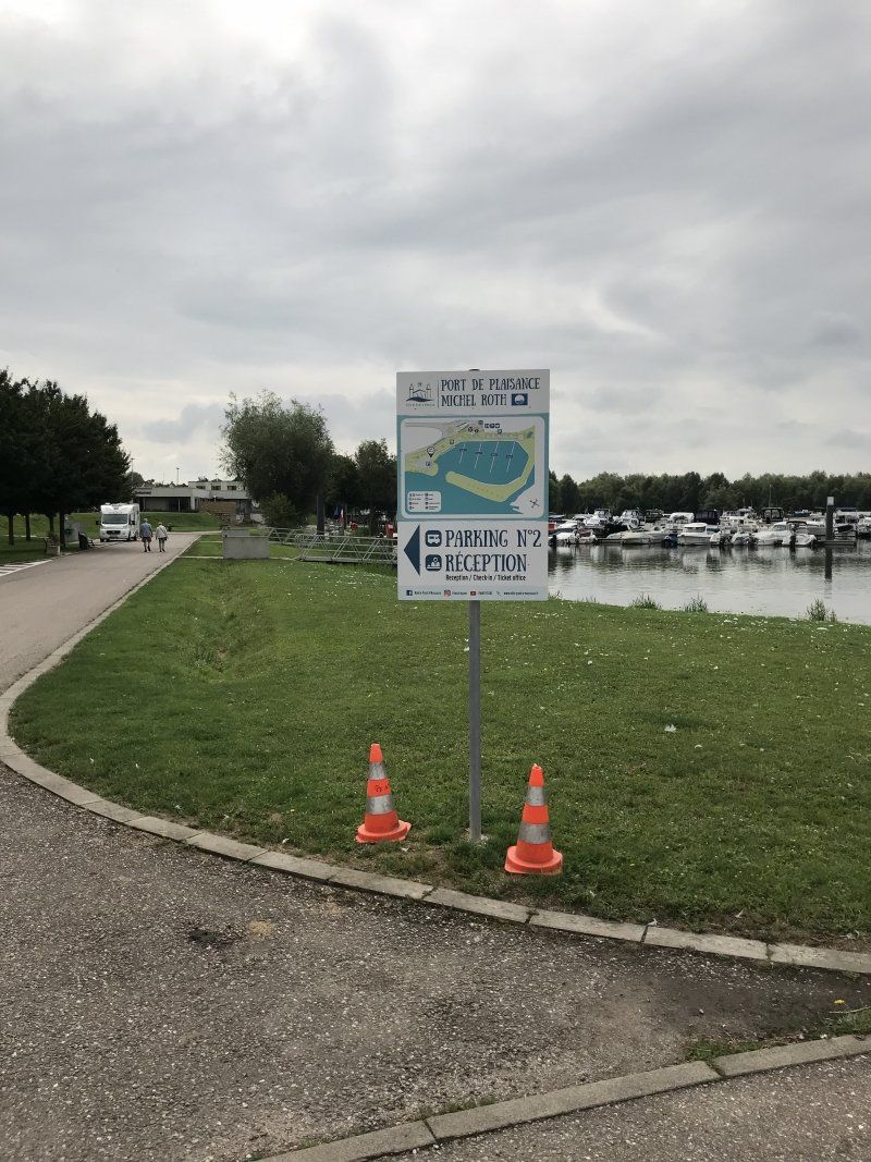
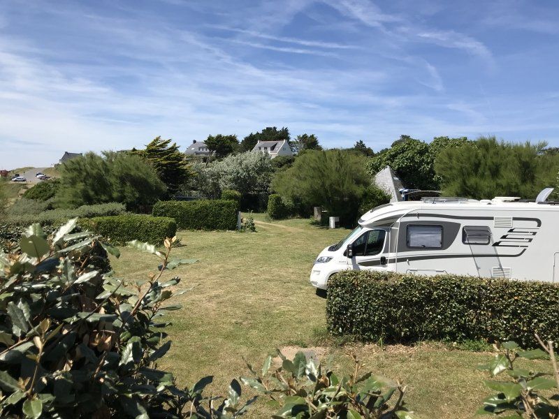
Stellplatz
Nice SP as a stop on the way to the Loire.
54700 Pont-à-Mousson, Frankreich
48° 54' 11.1" N 6° 3' 40.2" E
48.9030771 6.0611647
• Head southwest on Boulevard du Maréchal de Lattre de Tassigny.
• Turn left onto Boulevard du Maréchal de Lattre de Tassigny (D120). Go for 161 m.
• Pass 2 roundabouts and continue on Avenue des États-Unis (D120). Go for 1.1 km.
• Continue on A313 toward Pompey/Nancy. Go for 2.4 km.
• Continue on A31. Go for 25.3 km.
• Take the exit toward Lyon/Paris/Dijon/Toul onto A31. Go for 132 km.
• Take the exit toward Paris/Troyes/Chaumont onto A5. Go for 162 km.
• Take the exit toward Sens/Provins/Orléans onto A19. Go for 28.5 km.
• Take the exit toward Orléans/Montargis onto A19. Go for 35.3 km.
• Take the exit toward Paris/Fontainebleau/Nevers. Go for 1.2 km.
• Take the exit onto A77. Go for 23.4 km.
• Take exit 18.1 toward Nogent S/ V./Varennes-Changy. Go for 265 m.
• Keep right toward D41. Go for 780 m.
• Take the 2nd exit from roundabout onto D41 toward Varennes-Changy/Lorris. Go for 253 m.
• Continue on Lieu-dit Changy Les Bois (D41). Go for 208 m.
• Continue on D41. Go for 821 m.
• Continue on Rue de Nogent (D41). Go for 1.2 km.
• Continue on Rue de Lorris (D41). Go for 305 m.
• Continue on Route de Lorris (D41). Go for 3.5 km.
• Continue on D41. Go for 2.4 km.
• Continue on Route de Varennes (D41). Go for 223 m.
• Turn right onto Route de Gien (D44). Go for 208 m.
• Turn left onto Route d'Ouzouer-sur-Loire (D119). Go for 4.2 km.
• Continue on D119. Go for 4.6 km.
• Continue on Lieu-dit Le Gros Tau (D119). Go for 104 m.
• Continue on D119. Go for 1.1 km.
• Continue on Route de Montereau (D119). Go for 120 m.
• Continue on Lieu-dit Le Marchais Mignon (D119). Go for 102 m.
• Continue on Route de Montereau (D119). Go for 363 m.
• Continue on D119. Go for 324 m.
• Continue on Lieu-dit Champlong (D119). Go for 54 m.
• Continue on D119. Go for 144 m.
• Continue on Rue de la Forêt (D119). Go for 1.2 km.
• Take the 2nd exit from roundabout onto Rue de la Forêt (D119). Go for 322 m.
• Continue on Rue Sadi Carnot (D119). Go for 8.4 km.
• Take the 3rd exit from roundabout onto D948. Go for 582 m.
• Turn left onto Avenue de Béthune. Go for 828 m.
• Take the 1st exit from roundabout onto Chemin de la Salle Verte. Go for 35 m.
• Arrive at Chemin de la Salle Verte. Your destination is on the left.
☍
443,8 km
(3 hrs. 53 min.)
Day
Stellplatz
Parking lot character with V / E. Ok for overnight. The city is within walking distance. We couldn't find a nice restaurant. Lots of pizzerias and kebab shops.
Chemin de la Salle Verte, 45600 Sully-sur-Loire, Frankreich
47° 46' 15.9" N 2° 23' 2.3" E
47.7710883 2.3839851
• Head north on Chemin de la Salle Verte. Go for 14 m.
• Take the 2nd exit from roundabout onto Avenue de Béthune. Go for 859 m.
• Turn right onto D948. Go for 484 m.
• Take the 3rd exit from roundabout onto Rue d'Orléans (D60). Go for 6.7 km.
• Turn right onto Rue du Gué de Margot (D148). Go for 544 m.
• Continue on Route de Bray-en-Val (D148). Go for 170 m.
• Continue on D148. Go for 10 m.
• Turn right onto Route de Saint-Aignan (D148). Go for 980 m.
• Continue on Lieu-dit Réveillon (D148). Go for 16 m.
• Continue on Route de Saint-Aignan (D148). Go for 1.6 km.
• Continue on D148. Go for 753 m.
• Continue on Rue Augustin Pignault (D148). Go for 285 m.
• Continue on Route de Saint-Benoît-sur-Loire (D148). Go for 168 m.
• Turn left onto D952. Go for 4.7 km.
• Pass 2 roundabouts and continue on D952/D960. Go for 3.8 km.
• Take ramp onto D2060 toward Orléans. Go for 29.4 km.
• Take ramp onto D2701 toward A10 (A71)-(A19)/Paris/Vierzon/Le Mans/Pôle Santé Oreliance. Go for 3.0 km.
• Take left ramp onto A10 (L'Aquitaine) toward Toulouse/Vierzon/Bordeaux/Blois. Go for 55.7 km.
• Take exit 17 toward Blois/Vendôme/La Chaussée-St Victor onto D952 A. Go for 1.3 km.
• Take the 2nd exit from Rond-Point des Châteaux roundabout onto D956 toward Blois/D952 A. Go for 993 m.
• Take the 3rd exit from roundabout onto Boulevard des Cités Unies (D956) toward Blois-Sud. Go for 1.7 km.
• Take ramp. Go for 234 m.
• Turn right onto Avenue de Verdun (D952). Go for 11.2 km.
• Take the 2nd exit from roundabout onto D952 toward Onzain/Amboise. Go for 6.8 km.
• Take the 3rd exit from roundabout onto D1 toward Chaumont S/Loire/Chaumont S/L. Go for 678 m.
• Turn right onto Rue du Maréchal Leclerc (D114). Go for 14 m.
• Turn right onto Rue du Passeur. Go for 183 m.
• Turn right onto Chemin du Camping. Go for 271 m.
• Turn left. Go for 42 m.
• Arrive at your destination on the right.
☍
132,4 km
(1 hrs. 35 min.)
Day
Day
Day
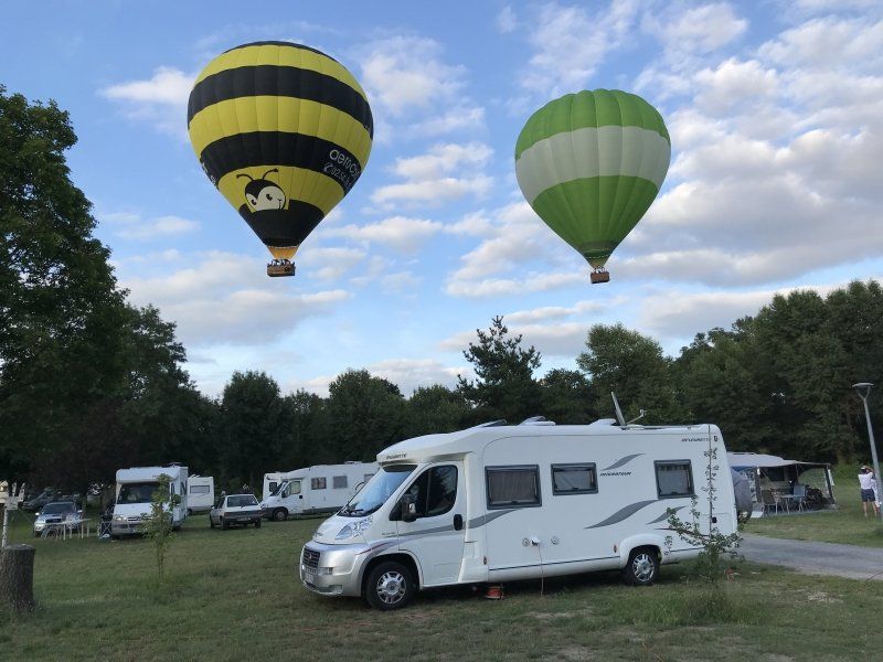
Camping Chaumont sur Loire
We really liked this CP with V / E directly on the Loire. Quiet location, no parcelling. There are 2 good restaurants in the village.
Ideal starting point for bike tours to Blois and Amboise. Each one-way route approx. 20 km.
Les Varennes, 41150 Chaumont-sur-Loire, Frankreich
47° 29' 7.5" N 1° 11' 41" E
47.4854177 1.1947310
• Head toward Chemin du Camping. Go for 42 m.
• Turn right onto Chemin du Camping. Go for 271 m.
• Turn left onto Rue du Passeur. Go for 183 m.
• Turn right onto Rue du Maréchal Leclerc (D114). Go for 288 m.
• Continue on Rue du Maréchal de Lattre de Tassigny (D751). Go for 15.0 km.
• Turn left and take ramp onto Boulevard Saint-Denis Hors (D31) toward Bléré/Loches/Montrichard/Chenonceaux/Amboise. Go for 1.0 km.
• Pass 3 roundabouts and continue on Boulevard Saint-Denis Hors (D31). Go for 5.5 km.
• Take the 3rd exit from roundabout onto Boulevard Saint-Denis Hors (D31) toward A85/Bléré/Loches/St Martin le Beau. Go for 7.8 km.
• Continue on D976. Go for 2.0 km.
• Take ramp toward A85/Reignac/Genillé/Loches. Go for 267 m.
• Turn right onto D31. Go for 3.4 km.
• Take the 1st exit from roundabout onto A85 toward Tours. Go for 68.6 km.
• Take exit 5 toward Bourgueil/Port-Boulet/Avoine/Chinon/Tours. Go for 1.2 km.
• Take the 3rd exit from roundabout onto Route Château-la-Vallière (D749) toward Tours/Port-Boulet/Avoine/Chinon. Go for 1.1 km.
• Turn right onto Rue de Tours (D952) toward E60/Saumur/Chouzé S/Loire. Go for 8.8 km.
• Take the 3rd exit from roundabout onto D952 A toward Turquant/Montsoreau. Go for 928 m.
• Take the 1st exit from roundabout onto D947 toward Saumur/Turquant. Go for 1.3 km.
• Pass 2 roundabouts and continue on Quai du Jagueneau (D947). Go for 6.9 km.
• Arrive at Quai du Jagueneau (D947).
☍
124,8 km
(1 hrs. 30 min.)
Day
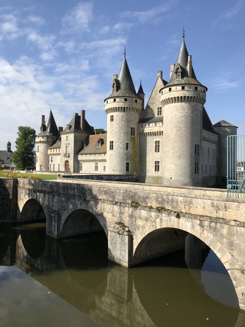
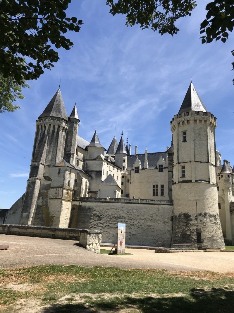
Aire De Camping Car
Ideal SP for visiting the city of Saumur.
495 Route de Montsoreau, 49400 Saumur, Frankreich
47° 14' 30.3" N 0° 1' 22.4" W
47.2417594 -0.0228846
• Head west on Quai du Jagueneau (D947). Go for 1.8 km.
• Take the 1st exit from roundabout onto Quai Lucien Gautier (D947). Go for 398 m.
• Take the 1st exit from roundabout onto Pont Cessart (D947). Go for 397 m.
• Pass 3 roundabouts and continue on Pont des Cadets de Saumur (D947). Go for 452 m.
• Take the 2nd exit from Rond-Point Noëlla Rouget roundabout onto Rue de Rouen toward St Lambert/Saumur-Nord. Go for 85 m.
• Take the 2nd exit from roundabout onto Rue de Rouen. Go for 986 m.
• Take the 2nd exit from Rond-Point des Fusillés roundabout onto Avenue des Fusillés. Go for 1.8 km.
• Continue on D347. Go for 2.2 km.
• Take the 2nd exit from Rond-Point de la Ronde roundabout onto D767 toward Angers/Tours/Le Mans/Allonnes/Vernantes. Go for 577 m.
• Take the 3rd exit from roundabout toward Le Mans/Angers/Tours. Go for 161 m.
• Take ramp onto A85 toward Nantes/Le Mans/Angers. Go for 36.9 km.
• Continue toward Nantes/Angers. Go for 212 m.
• Take the exit onto A11 (L'Océane). Go for 104 km.
• Continue on A844 (Périphérique Nord). Go for 4.8 km.
• Continue on A82. Go for 1.6 km.
• Continue on N165. Go for 25.9 km.
• Take ramp onto N171 toward La Baule/St Nazaire/Savenay-Centre. Go for 23.5 km.
• Take ramp onto Route Bleue (D213) toward La Baule/Guérande/St Nazaire-Ouest. Go for 4.2 km.
• Keep left onto Route Bleue (D213) toward La Baule/Pornichet/Guérande/P.A. Brais Pedras. Go for 13.8 km.
• Take the 3rd exit from roundabout onto Rocade Sud (D99) toward Guerande-Cité Médiévale/Le Pouliguen/Le Croisic. Go for 400 m.
• Take the 2nd exit from roundabout onto Rocade Sud (D774 A). Go for 1.1 km.
• Take the 2nd exit from roundabout onto D774 toward Le Pouliguen/Batz-sur-Mer/Le Croisic/Saillé. Go for 2.2 km.
• Take the 2nd exit from Rond-Point de la Dépêche roundabout onto D774. Go for 699 m.
• Take the 2nd exit from roundabout onto Lieu-dit Leniphen (D45). Go for 1.1 km.
• Take the 1st exit from Place de la Gare roundabout onto Boulevard de Kisslegg (D45). Go for 611 m.
• Pass 4 roundabouts and continue on Boulevard de l'Atlantique (D45). Go for 2.2 km.
• Continue on Route de la Govelle (D45). Go for 514 m.
• Take the 2nd exit from roundabout onto Route de la Govelle (D45). Go for 298 m.
• Enter the roundabout. Go for 53 m.
• Arrive at your destination on the right.
☍
233,0 km
(2 hrs. 20 min.)
Day
Day
Day
Camping La Govelle
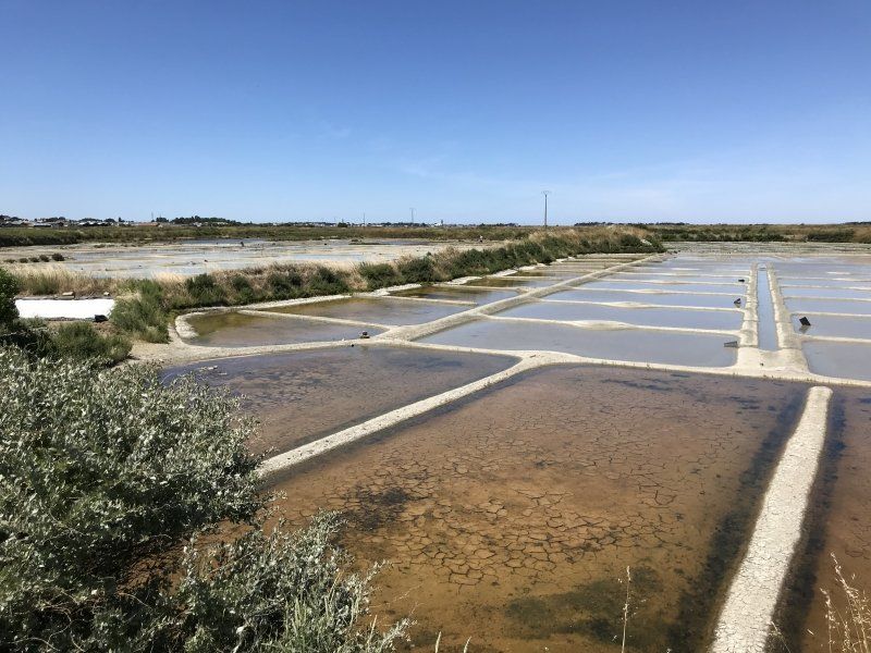
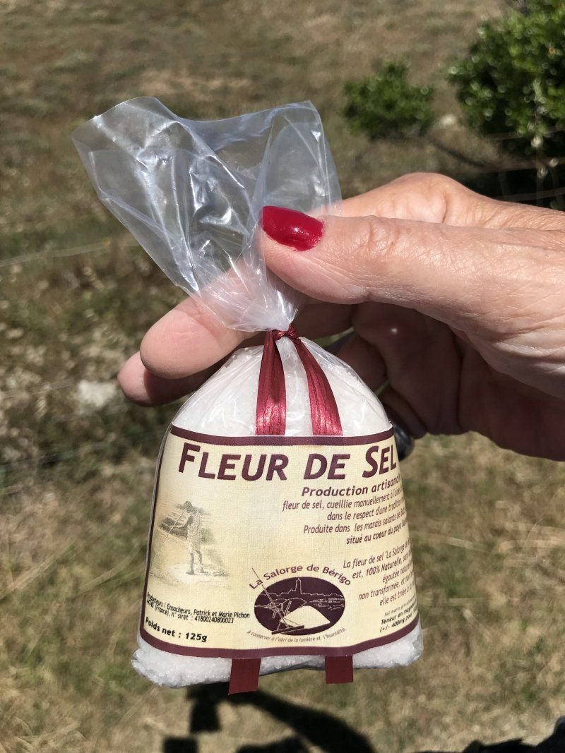
The square is close to the road, but is quiet at night. The operating couple is very hard-working and helpful. The nearby salt fields of the Guerande can be explored by bike. Salt is sold in various salt pans.
There is a good restaurant near the CP.
10 Route de la Govelle, 44740 Batz-sur-Mer, Frankreich
47° 16' 9.6" N 2° 27' 23.6" W
47.2693290 -2.4565601
• Follow the roundabout. Go for 8 m.
• Take the 1st exit from roundabout onto Route de la Govelle (D45). Go for 270 m.
• Take the 2nd exit from roundabout onto Route de la Govelle (D45). Go for 535 m.
• Continue on Boulevard de l'Atlantique (D45). Go for 1.0 km.
• Take the 3rd exit from roundabout onto Boulevard de l'Atlantique (D45) toward La Baule/Centre Ville/Stade Félix Monville. Go for 480 m.
• Pass 3 roundabouts and continue on Boulevard de Kisslegg (D45). Go for 1.3 km.
• Take the 4th exit from Place de la Gare roundabout onto Place de la Gare (D45). Go for 1.2 km.
• Take the 1st exit from roundabout onto D774. Go for 698 m.
• Take the 2nd exit from Rond-Point de la Dépêche roundabout onto D774 toward Guérande. Go for 2.2 km.
• Take the 2nd exit from roundabout onto Rocade Sud (D774 A) toward D774/Guérande/St Nazaire. Go for 1.1 km.
• Take the 2nd exit from roundabout onto Rocade Sud (D99). Go for 336 m.
• Take the 4th exit from roundabout onto Route Bleue (D99 E) toward D774/Vannes/La Turballe/Guérande. Go for 929 m.
• Pass 4 roundabouts and continue on Route Bleue (D774). Go for 10.9 km.
• Turn left toward Pompas. Go for 339 m.
• Continue on Rue du Mès. Go for 345 m.
• Turn left onto Rue de l'Océan (D83). Go for 3.7 km.
• Continue on Rue du Calvaire (D33). Go for 179 m.
• Turn right onto Place Olivier Guichard. Go for 74 m.
• Turn right onto Rue du Centre (D83). Go for 2.1 km.
• Turn right onto D139. Go for 760 m.
• Continue on Lieu-dit Tahon (D139). Go for 97 m.
• Continue on D139. Go for 611 m.
• Continue on Lieu-dit Kermarie (D139). Go for 518 m.
• Continue on Lieu-dit La Corolais (D139). Go for 124 m.
• Continue on D139. Go for 1.4 km.
• Continue on Rue de la Butte (D139). Go for 353 m.
• Continue on D139. Go for 287 m.
• Continue on Lieu-dit Le Pont (D139). Go for 245 m.
• Continue on D139. Go for 38 m.
• Turn right onto Rue Paul Ladmirault (D34). Go for 853 m.
• Take the 3rd exit from roundabout onto D139. Go for 2.4 km.
• Pass 3 roundabouts and continue on D139. Go for 5.1 km.
• Take the 2nd exit from roundabout toward Vannes/Muzillac. Go for 243 m.
• Take ramp onto N165. Go for 27.0 km.
• Keep left onto N165 toward Vannes-Centre/Lorient/Brest/Rennes. Go for 6.8 km.
• Keep left onto Rocade de Vannes (N165) toward Lorient/Brest/Vannes-Ouest/Arradon/Auray. Go for 17.3 km.
• Take ramp toward Crach/St Philibert/La Trinité S/Mer/Locmariaquer. Go for 778 m.
• Take the 1st exit from roundabout onto D28 toward Crac'h/Locmariaquer/St Philibert/La Trinité S/ Mer. Go for 3.9 km.
• Pass 4 roundabouts and continue on D28. Go for 3.0 km.
• Take the 2nd exit from roundabout onto Route de Locmariaquer (D781). Go for 3.7 km.
• Turn right onto Route d'Auray. Go for 34 m.
• Continue on C5. Go for 98 m.
• Continue on Voie des Mégalithes (C5). Go for 1.1 km.
• Take the 3rd exit from roundabout onto Allée de Kreu Er Morh. Go for 247 m.
• Turn slightly right onto Allée de Kreu Er Morh. Go for 33 m.
• Continue on Chemin du Bereu. Go for 872 m.
• Continue on Allée Kreu Er Morh. Go for 39 m.
• Turn right onto Rue Henri Ézan (C4). Go for 503 m.
• Arrive at Rue Henri Ézan. Your destination is on the right.
☍
106,0 km
(1 hrs. 31 min.)
Day
Camping Municipal La Falaise
10 rue Henri Ezan, 56740 Locmariaquer, Frankreich
47° 33' 19.3" N 2° 56' 23.3" W
47.5553511 -2.9398084
• Head toward Lieu-dit Kerpenhir on Rue Henri Ézan. Go for 537 m.
• Continue on Route de Kerpenhir (C4). Go for 826 m.
• Turn left onto Rue Er Hastel. Go for 329 m.
• Turn left onto Rue de la Plage. Go for 274 m.
• Take the 1st exit from roundabout onto Voie des Mégalithes. Go for 1.2 km.
• Continue on C5. Go for 126 m.
• Turn left onto Route d'Auray (D781). Go for 14 m.
• Continue on Route d'Auray (D781). Go for 3.6 km.
• Take the 2nd exit from roundabout onto Pourhors (D781). Go for 670 m.
• Pass 2 roundabouts and continue on Lieu-dit Kernivilit (D781). Go for 2.4 km.
• Take the 3rd exit from Rue des Résistants roundabout onto Rue des Résistants (D781). Go for 290 m.
• Take the 2nd exit from roundabout onto Rue des Résistants (D781). Go for 321 m.
• Take the 1st exit from Giratoire Alain Barrière roundabout onto Rue de Carnac (D781). Go for 105 m.
• Pass 2 roundabouts and continue on Route de la Trinité-sur-Mer (D781). Go for 3.7 km.
• Take the 1st exit from roundabout onto Rue de Poul Person. Go for 216 m.
• Take the 2nd exit from roundabout onto Rue du Praden. Go for 72 m.
• Take the 1st exit from roundabout onto Rue de Bellevue. Go for 489 m.
• Turn left onto Rue du Ménec (D196). Go for 170 m.
• Take the 1st exit from Carrefour Le Nilestrec roundabout onto Rue Saint-Cornely (D781). Go for 575 m.
• Take the 2nd exit from roundabout onto Route de Plouharnel (D781). Go for 2.1 km.
• Take the 3rd exit from Rond-Point de l'Océan roundabout onto Rue du Préleran (D781). Go for 278 m.
• Pass 3 roundabouts and continue on Route d'Erdeven (D781). Go for 4.7 km.
• Arrive at Rue des Menhirs (D781). Your destination is on the right.
☍
23,0 km
( 32 min.)
Erdeven, Frankreich
58 Rue des Menhirs, 56410 Erdeven, Frankreich
47° 38' 4.9" N 3° 8' 57.1" W
47.6347048 -3.1491967
• Head northwest on Rue des Menhirs (D781). Go for 640 m.
• Take the 3rd exit from roundabout onto Rue des Menhirs (D781). Go for 902 m.
• Pass 5 roundabouts and continue on Route des Quatre Chemins (D781). Go for 4.4 km.
• Take the 3rd exit from roundabout onto Route de Pont-Lorois (D781). Go for 1.4 km.
• Take the 2nd exit from roundabout onto Rue du Pont Lorois (D781). Go for 432 m.
• Take the 3rd exit from roundabout onto D781. Go for 3.8 km.
• Pass 2 roundabouts and continue on Route de Plouhinec (D781). Go for 6.0 km.
• Continue on Route de Port-Louis (D781). Go for 130 m.
• Take the 2nd exit from Route de Port-Louis roundabout onto Route de Port-Louis (D781). Go for 743 m.
• Continue on Avenue de la Côte Rouge (D781). Go for 111 m.
• Take the 2nd exit from roundabout onto Avenue de la Côte Rouge (D781). Go for 114 m.
• Turn right onto Avenue de la Côte Rouge (D781). Go for 116 m.
• Arrive at Avenue de la Côte Rouge (D781).
☍
18,9 km
( 26 min.)
Port-Louis, Frankreich
4 Avenue de la Côté Rouge, 56290 Port-Louis, Frankreich
47° 42' 33.1" N 3° 20' 42.2" W
47.7091944 -3.3450562
• Head toward Place de l'Avancée on Avenue de la Côte Rouge (D781). Go for 6 m.
• Turn right onto Avenue de Kerbel (D781). Go for 822 m.
• Take the 2nd exit from roundabout onto Route de Port-Louis (D781). Go for 556 m.
• Pass 3 roundabouts and continue on Route de Port-Louis (D781). Go for 1.2 km.
• Take the 3rd exit from Rond-Point de Kersabiec roundabout onto Route d'Hennebont (D781). Go for 2.4 km.
• Take the 2nd exit from roundabout onto D781. Go for 2.6 km.
• Take the 2nd exit from roundabout onto D781. Go for 3.2 km.
• Take the 2nd exit from Rond-Point de Locoyarne roundabout onto D781. Go for 292 m.
• Take left ramp onto Voie Express de Nantes à Brest (N165) toward Lorient. Go for 6.8 km.
• Keep left onto Voie Express de Nantes à Brest (N165) toward Quimper/Brest/Quéven/Ploemeur/Quimperlé/Aéroport Lorient Lann-Bihoué. Go for 18.9 km.
• Take ramp toward Kergostiou/D16/Moëlan S/Mer/Clohars-Carnoët/Quimperlé-Centre. Go for 267 m.
• Turn right onto Rue de Croas-Chuz toward Quimperlé/Moëlan S/Mer/Clohars-Carnoët. Go for 15 m.
• Continue on Rue Samuel Billette. Go for 418 m.
• Take the 2nd exit from roundabout onto Rue de Moélan (D16). Go for 992 m.
• Take the 3rd exit from Rond-Point des Plages roundabout onto Rue d'Armorique (D16). Go for 2.4 km.
• Take the 1st exit from Giratoire de Gare la Forêt roundabout onto Lieu-dit Gare la Forêt (D116). Go for 392 m.
• Continue on Lieu-dit Kerfleury (D116). Go for 296 m.
• Continue on Lieu-dit Lambeurnou (D116). Go for 232 m.
• Continue on Lieu-dit Kerguillaouet (D116). Go for 229 m.
• Continue on D116. Go for 2.1 km.
• Continue on Rue de Quimperlé (D116). Go for 97 m.
• Take the 2nd exit from roundabout onto Rue de Quimperlé (D116). Go for 1.2 km.
• Continue on Rue des Écoles (D116). Go for 371 m.
• Take the 2nd exit from roundabout onto Rue des Plages (D116). Go for 235 m.
• Take the 1st exit from roundabout onto Rue des Plages (D116). Go for 605 m.
• Continue on Route de Kerfany (D116). Go for 17 m.
• Take the 1st exit from roundabout onto Route de Kerfany (D116). Go for 2.4 km.
• Continue on Rue de Lann Kerguipp (D116). Go for 973 m.
• Continue on Rue Louis le Guennec (D116). Go for 1.0 km.
• Continue on Rue des Embruns (D116). Go for 481 m.
• Turn left onto Route de l'Île Percée. Go for 1.6 km.
• Continue on Lieu-dit Trenez. Go for 213 m.
• Arrive at Lieu-dit Trenez. Your destination is on the right.
☍
53,1 km
( 46 min.)
Day
Day
Day
Camping de l’île percée
The course is out of the way and still has something original about it. Take supplies with you!
The place was managed in 2018 by an elderly couple. For reasons of age, they announced a change of ownership.
Bike excursion to the lovely town of Pont Aven, approx. 20 km.
Trenez, 29350 Moëlan-sur-Mer, Frankreich
47° 47' 16.8" N 3° 42' 2" W
47.7879887 -3.7005472
• Head west on Lieu-dit Trenez. Go for 213 m.
• Continue on Route de l'Île Percée. Go for 1.6 km.
• Turn right onto Rue des Embruns (D116). Go for 481 m.
• Continue on Rue Louis le Guennec (D116). Go for 1.0 km.
• Continue on Rue de Lann Kerguipp (D116). Go for 973 m.
• Continue on Route de Kerfany (D116). Go for 2.0 km.
• Turn left onto Rue Marcel Gannat (C14). Go for 582 m.
• Turn left onto Lieu-dit Kerberthou (D24). Go for 5.9 km.
• Take the 4th exit from roundabout onto Rue de la Gare (D783). Go for 557 m.
• Take the 2nd exit from roundabout onto Rue Alain Berthou (D783). Go for 4.4 km.
• Take the 2nd exit from roundabout onto Rue du Général de Gaulle (D783). Go for 376 m.
• Turn right onto Rue Émile Bernard (D783). Go for 1.1 km.
• Pass 2 roundabouts and continue on Rue de Trégunc (D783). Go for 6.8 km.
• Arrive at Rue de Pont-Aven (D783).
☍
26,0 km
( 29 min.)
Trégunc, Frankreich
47 Route de Pont-Aven, 29910 Trégunc, Frankreich
47° 51' 17.8" N 3° 50' 51.5" W
47.8549516 -3.8476400
• Head toward Rue des Quatre Vents on Rue de Pont-Aven (D783). Go for 327 m.
• Take the 1st exit from roundabout onto Place de la Mairie (D783). Go for 59 m.
• Take the 2nd exit from roundabout onto Place de la Mairie (D783). Go for 514 m.
• Pass 8 roundabouts and continue on Rue de la Villeneuve (D783). Go for 7.6 km.
• Take the 3rd exit from Rond-Point Keramporiel roundabout onto Rue de Keramporiel (D783). Go for 2.7 km.
• Pass 2 roundabouts and continue on Lieu-dit Croas Avalou (D783). Go for 2.5 km.
• Take the 2nd exit from roundabout onto D44. Go for 1.7 km.
• Pass 4 roundabouts and continue on Cité de Ker Elo (D44). Go for 3.5 km.
• Take the 3rd exit from Rond-Point de Ker Elo Haut roundabout onto Route de Quimper (D45). Go for 577 m.
• Take the 2nd exit from Rond-Point de l'Odet roundabout onto Rue de l'Odet (D44). Go for 286 m.
• Arrive at Rue de l'Odet (D44). Your destination is on the left.
☍
19,7 km
( 24 min.)
Fouesnant, Frankreich
47 Rue de l'Odet, 29170 Fouesnant, Frankreich
47° 53' 24.9" N 4° 1' 3.4" W
47.8902533 -4.0176146
• Head toward Hent Parc Leur on Rue de l'Odet (D44). Go for 293 m.
• Take the 1st exit from roundabout onto Route de Bénodet (D44). Go for 103 m.
• Take the 3rd exit from roundabout onto Route de Bénodet (D44). Go for 548 m.
• Pass 7 roundabouts and continue on Avenue de Fouesnant (D44). Go for 6.4 km.
• Take the 2nd exit from Giratoire de Penfoul roundabout onto Route de Quimper (D34). Go for 192 m.
• Take the 2nd exit from Giratoire de l'Odet roundabout onto D44. Go for 2.8 km.
• Pass 3 roundabouts and continue on Route de Pont-l'Abbé (D44). Go for 2.9 km.
• Take the 3rd exit from roundabout onto D44. Go for 3.7 km.
• Take the 3rd exit from Rond-Point de Kermaria roundabout onto D785. Go for 2.2 km.
• Take the 3rd exit from roundabout onto D785. Go for 1.1 km.
• Take the 2nd exit from roundabout onto D785. Go for 902 m.
• Take the 1st exit from roundabout onto Route de Plomeur (D785). Go for 3.2 km.
• Pass 5 roundabouts and continue on Route de Plomeur (D785). Go for 4.9 km.
• Continue on Hent Prad Gouzien (D785). Go for 167 m.
• Continue on Rue Edmond Michelet (D785). Go for 187 m.
• Take the 1st exit from roundabout onto Rue Edmond Michelet (D785). Go for 314 m.
• Take the 3rd exit from roundabout onto Rue Edmond Michelet (D785). Go for 335 m.
• Turn right onto Rue François Merrien (D785). Go for 88 m.
• Turn left onto Rue de la Gare. Go for 551 m.
• Continue on Rue de l'École de Voile. Go for 1.0 km.
• Turn right onto Rue de l'École de Voile. Go for 222 m.
• Arrive at Rue de l'École de Voile. Your destination is on the left.
☍
32,2 km
( 34 min.)
Day
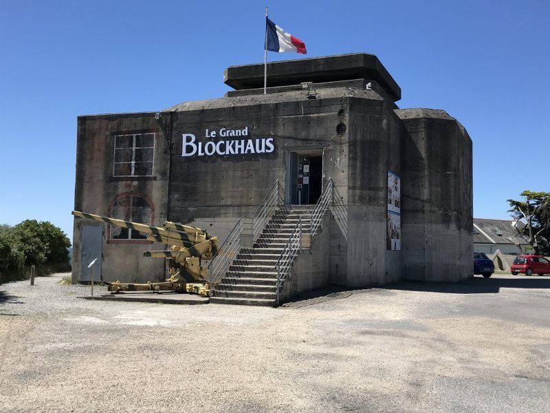
CAMPING LE GRAND BLEU
Excursion to the remarkable lighthouse Phare Eckmühl
Plage du Steir, Rue de l'École de Voile, 29760 Penmarch, Frankreich
47° 47' 57.5" N 4° 19' 37.3" W
47.7993192 -4.3270254
• Head toward Lieu-dit Le Manoir du Stêr on Rue de l'École de Voile. Go for 222 m.
• Turn left onto Rue de l'École de Voile. Go for 1.0 km.
• Continue on Rue de la Gare. Go for 551 m.
• Turn right onto Rue François Merrien (D785). Go for 88 m.
• Turn left onto Rue Edmond Michelet (D785). Go for 282 m.
• Take the 1st exit from roundabout onto Rue Edmond Michelet (D785). Go for 295 m.
• Take the 2nd exit from roundabout onto Rue Edmond Michelet (D785). Go for 218 m.
• Continue on Hent Prad Gouzien (D785). Go for 167 m.
• Continue on Route de Plomeur (D785). Go for 685 m.
• Pass 3 roundabouts and continue on Rue Louis Mehu (D785). Go for 3.9 km.
• Take the 3rd exit from roundabout onto Route de Saint-Jean Trolimon (D57). Go for 2.3 km.
• Take the 2nd exit from roundabout onto Hent Braz Kap-Kaval (D57). Go for 4.6 km.
• Turn left onto Rue Louis Hémon. Go for 378 m.
• Turn left onto Rue Louis Pasteur (D2). Go for 7.6 km.
• Take the 2nd exit from roundabout onto Rue de Pont l'Abbé (D2). Go for 7.4 km.
• Turn left onto Rue du Centre (D784). Go for 3.5 km.
• Continue on D2. Go for 16 m.
• Continue on Route d'Audierne (D784). Go for 3.4 km.
• Take the 2nd exit from Rond-Point de Ty-Frapp roundabout onto Rue de Trébeuzec (D784). Go for 3.0 km.
• Take the 2nd exit from Rond-Point de la Libération roundabout onto Quai Anatole France (D784). Go for 288 m.
• Continue on Rue de la Liberté (D784). Go for 31 m.
• Take the 1st exit from roundabout onto Place de la Liberté (D784). Go for 64 m.
• Take the 1st exit from roundabout onto Rue Victor Hugo (D784). Go for 149 m.
• Continue on Rue du 14 Juillet (D784). Go for 1.1 km.
• Turn left onto Rue Raymond Couillandre. Go for 118 m.
• Turn right toward Rue de Kerivoas/D784. Go for 205 m.
• Take the 2nd exit from roundabout onto Rue de Kerivoas (D784). Go for 318 m.
• Continue on Rue de la République (D784). Go for 297 m.
• Take the 2nd exit from roundabout onto Rue de la Croix Rouge (D784). Go for 462 m.
• Continue on Route de la Pointe du Raz (D784). Go for 1.0 km.
• Continue on Route d'Audierne (D784). Go for 4.5 km.
• Continue on Rue de la Plage (D784). Go for 74 m.
• Continue on Route du Petit Loc'h (D784). Go for 903 m.
• Continue on Lieu-dit Clucarec (D784). Go for 146 m.
• Continue on Lieu-dit Kerstrat (D784). Go for 468 m.
• Continue on Rue Pierre Brossolette (D784). Go for 3.2 km.
• Continue on Rue des Langoustiers (D784). Go for 1.4 km.
• Continue on D784. Go for 55 m.
• Continue toward Lieu-dit La Pointe du Raz. Go for 121 m.
• Turn right onto Lieu-dit La Pointe du Raz. Go for 1.2 km.
• Arrive at Lieu-dit La Pointe du Raz.
☍
55,9 km
(1 hrs. 4 min.)
Day
Pointe du Raz
29770 Plogoff, Frankreich
48° 2' 22.7" N 4° 44' 9.4" W
48.0396363 -4.7359443
• Head east on Lieu-dit La Pointe du Raz. Go for 1.2 km.
• Turn left toward D784. Go for 107 m.
• Turn right onto D784. Go for 16 m.
• Turn slightly left toward Rue des Langoustiers/D784. Go for 70 m.
• Turn right onto Rue des Langoustiers (D784). Go for 1.4 km.
• Turn left onto Route de la Baie (D607). Go for 128 m.
• Continue on D607. Go for 1.0 km.
• Continue on Lieu-dit La Baie des Trépassés (D607). Go for 61 m.
• Continue on D607. Go for 118 m.
• Continue on Lieu-dit Baie des Trépassés (D607). Go for 280 m.
• Continue on Lieu-dit Rozveur (D607). Go for 635 m.
• Continue on D607. Go for 543 m.
• Continue on Lieu-dit Trouguer (D607). Go for 104 m.
• Turn right onto Lieu-dit Croix Kerninon (D7). Go for 131 m.
• Continue on Lieu-dit Kerninon (D7). Go for 494 m.
• Continue on D7. Go for 158 m.
• Continue on Lieu-dit Castel Meur (D7). Go for 1.1 km.
• Continue on D7. Go for 1.2 km.
• Continue on Lieu-dit Bellevue (D7). Go for 254 m.
• Continue on D7. Go for 254 m.
• Continue on Lieu-dit Greanec (D7). Go for 168 m.
• Continue on D7. Go for 235 m.
• Continue on Lieu-dit Rozigou (D7). Go for 363 m.
• Continue on D7. Go for 251 m.
• Continue on Lieu-dit Croix de Trevenan (D7). Go for 289 m.
• Continue on D7. Go for 408 m.
• Continue on Lieu-dit Kerharo (D7). Go for 180 m.
• Continue on Lieu-dit Moulin de Kerharo (D7). Go for 632 m.
• Continue on Lieu-dit Kerharo (D7). Go for 255 m.
• Continue on Lieu-dit Kergond'Hui (D7). Go for 187 m.
• Continue on D7. Go for 952 m.
• Continue on Lieu-dit Kervarguen (D7). Go for 178 m.
• Continue on D7. Go for 229 m.
• Continue on Lieu-dit Interridy (D7). Go for 350 m.
• Continue on Lieu-dit Le Goalarn (D7). Go for 307 m.
• Continue on D7. Go for 2.2 km.
• Continue on Lieu-dit Moulin Castel (D7). Go for 83 m.
• Continue on Lieu-dit Kerguénec (D7). Go for 580 m.
• Continue on D7. Go for 1.0 km.
• Continue on Lieu-dit Lezugard Vihan (D7). Go for 1.7 km.
• Continue on Rue des Ajoncs (D7). Go for 268 m.
• Take the 1st exit from roundabout onto Rue des Bruyères (D7). Go for 247 m.
• Continue on D7. Go for 9 m.
• Continue on Rue Kreiz Ker (D7). Go for 141 m.
• Continue on Lieu-dit Rosco (D7). Go for 49 m.
• Take the 1st exit from roundabout onto Lieu-dit Rosco (D7). Go for 241 m.
• Continue on Lieu-dit Bicetre (D7). Go for 380 m.
• Continue on Lieu-dit Dalar (D7). Go for 1.4 km.
• Continue on Rue du Garde Francois Cotonea (D7). Go for 1.9 km.
• Continue on Lieu-dit Coat Pin (D7). Go for 433 m.
• Continue on D7. Go for 128 m.
• Continue on Lieu-dit Kerbalannec Vihan (D7). Go for 89 m.
• Continue on D7. Go for 1.2 km.
• Continue on Lieu-dit Lestreux (D7). Go for 315 m.
• Continue on Lieu-dit Menez Tour (D7). Go for 308 m.
• Continue on D7. Go for 587 m.
• Continue on Route de Beuzec-Cap-Sizun (D7). Go for 271 m.
• Take the 3rd exit from roundabout onto Rue Abbé Conan (D7). Go for 354 m.
• Continue on Place de l'Église (D7). Go for 66 m.
• Continue on Rue Luc Robet (D7). Go for 318 m.
• Take the 2nd exit from roundabout onto Rue Luc Robet (D7). Go for 188 m.
• Continue on Route de Douarnenez (D7). Go for 291 m.
• Continue on D7. Go for 29 m.
• Continue on Route de Douarnenez (D7). Go for 3.0 km.
• Continue on D7. Go for 354 m.
• Continue on Route de Poulhan (D7). Go for 870 m.
• Take the 1st exit from roundabout onto Route de Poulhan (D7). Go for 185 m.
• Continue on Rue du Commandant Fernand (D7). Go for 263 m.
• Take the 1st exit from Rond-Point du Cornigou roundabout onto Boulevard Jean Moulin (D7 A). Go for 408 m.
• Pass 2 roundabouts and continue on Boulevard Jean Moulin (D7 A). Go for 1.4 km.
• Take the 3rd exit from roundabout onto Rue Étienne Kernours (D765). Go for 119 m.
• Pass 2 roundabouts and continue on Rue Étienne Kernours (D765). Go for 647 m.
• Turn left onto Route de Brest. Go for 610 m.
• Take the 2nd exit from Rond-Point de Bréhuel roundabout onto Route de Bréhuel (D7). Go for 350 m.
• Take the 2nd exit from roundabout onto Route de Bréhuel (D7). Go for 643 m.
• Turn right onto Route du Ris (D7). Go for 3.5 km.
• Take the 2nd exit from Giratoire de Kroas Hent Tro roundabout onto D7. Go for 3.9 km.
• Take the 3rd exit from Rond-Point de Rosancelin roundabout onto Route de la Presqu'Île (D63). Go for 1.1 km.
• Take the 1st exit from Rond-Point de Kervellic roundabout onto Route de Kergoat (D7). Go for 276 m.
• Turn right onto Chemin du Styvel. Go for 184 m.
• Turn left onto Chemin de Kervellic. Go for 100 m.
• Turn slightly right onto Chemin de Ty Lokorn. Go for 10 m.
• Arrive at Chemin de Ty Lokorn. Your destination is on the right.
☍
46,8 km
( 50 min.)
Locronan, Frankreich
The village center is still completely medieval and therefore very worth seeing. It is easy to find a parking space, subject to fees.
19 Rue des Charrettes, 29180 Locronan, Frankreich
48° 5' 58.9" N 4° 12' 19.1" W
48.0997044 -4.2052962
• Head toward Rue des Charrettes on Chemin de Ty Lokorn. Go for 10 m.
• Turn right onto Route de Plonévez-Porzay. Go for 311 m.
• Take the 1st exit from Rond-Point du Ménec roundabout onto Route de Kergoat (D7). Go for 7.4 km.
• Pass 2 roundabouts and continue on Rue du Kreisker (D7). Go for 6.6 km.
• Turn right onto Rue de Kerlobret (D887). Go for 1.7 km.
• Take the 2nd exit from roundabout onto D887. Go for 92 m.
• Take the 3rd exit from roundabout onto Quai Charles de Gaulle (D887). Go for 192 m.
• Continue on Quai Charles de Gaulle (D770). Go for 4.2 km.
• Take left ramp onto N165 toward Brest. Go for 27.8 km.
• Arrive at N165.
☍
48,4 km
( 35 min.)
Loperhet, Frankreich
N165, 29470 Loperhet, Frankreich
48° 23' 1" N 4° 19' 17.4" W
48.3836245 -4.3215119
• Head west on N165. Go for 6.9 km.
• Keep left onto Pénétrante Sud (N165) toward Brest-Centre/Brest-Ports/Océanopolis. Go for 4.4 km.
• Take the 1st exit from Rond-Point des Foulques roundabout onto Route du Vieux Saint-Marc (E60) toward Brest-Centre/Port du Château. Go for 1.0 km.
• Take the 4th exit from Rond-Point Herman Melville roundabout onto Rue du Sénateur Pichon toward Brest-Centre/Hôpital Morvan. Go for 385 m.
• Take the 2nd exit from Place des Formes roundabout onto Place des Formes. Go for 70 m.
• Take the 2nd exit from Place des Formes roundabout onto Rue de l'Élorn toward Brest-Centre/Hôpital Morvan/Gare Maritime. Go for 414 m.
• Take the 2nd exit from Rond-Point du Sergent Pepper roundabout onto Rue Jean-Marie Le Bris. Go for 383 m.
• Take the 1st exit from Rond-Point du Parc à Chaines roundabout onto Rampe d'Accès au Port toward Brest-Centre/Hôpital Morvan/Recouvrance/Musée de la Marine. Go for 189 m.
• Take the 2nd exit from roundabout onto Avenue Franklin Roosevelt toward Recouvrance/Musée de la Marine. Go for 372 m.
• Turn slightly left onto Boulevard des Français Libres. Go for 55 m.
• Take the 1st exit from roundabout onto Rue du Château. Go for 83 m.
• Turn left onto Rue Pierre Brossolette. Go for 152 m.
• Take the 2nd exit from roundabout onto Rue Pierre Brossolette. Go for 71 m.
• Turn left onto Rond-Point Général Delestraint. Go for 85 m.
• Continue on Pont de Recouvrance. Go for 244 m.
• Continue on Rue de la Porte. Go for 154 m.
• Keep right onto Rue de la Porte. Go for 412 m.
• Continue on Rue Anatole France. Go for 1.7 km.
• Take the 2nd exit from Rond-Point de la Suède roundabout onto Rue Anatole France. Go for 274 m.
• Continue on Rue Victor Eusen. Go for 348 m.
• Pass 2 roundabouts and continue on Rue Victor Eusen. Go for 285 m.
• Continue on Rue du Conquet. Go for 378 m.
• Turn left onto Avenue 1ère D.F.L. Go for 220 m.
• Keep right onto Avenue 1ère D.F.L. (D789). Go for 1.0 km.
• Pass 4 roundabouts and continue on Lieu-dit Berbouguis (D789). Go for 13.0 km.
• Take the 3rd exit from Giratoire du Lannou roundabout onto Rue du Lannou (D85). Go for 1.1 km.
• Turn right onto Rue du Stade (D85). Go for 794 m.
• Turn right onto Rue Pen Ar Bed (D85). Go for 264 m.
• Continue on D85. Go for 13 m.
• Continue on Rue Saint-Mathieu (D85). Go for 332 m.
• Continue on Rue Saint-Mathieu (D85). Go for 216 m.
• Continue on Lieu-dit Trémeur (D85). Go for 396 m.
• Continue on D85. Go for 1.5 km.
• Continue on Rue Saint-Mathieu (D85). Go for 736 m.
• Continue on Place Saint-Tanguy (D85). Go for 104 m.
• Arrive at Place Saint-Tanguy (D85). Your destination is on the left.
☍
38,0 km
( 38 min.)
Plougonvelin, Frankreich
7 Place Saint-Tanguy, 29217 Plougonvelin, Frankreich
48° 19' 50.7" N 4° 46' 15.4" W
48.3307405 -4.7709485
• Head west on Place Saint-Tanguy (D85). Go for 42 m.
• Continue on D85. Go for 434 m.
• Continue on Lieu-dit Moulin du Goazel (D85). Go for 78 m.
• Continue on Route Touristique (D85). Go for 1.5 km.
• Arrive at Route Touristique (D85). Your destination is on the right.
☍
2,1 km
( 2 min.)
Le Conquet, Frankreich
90 Route Touristique, 29217 Le Conquet, Frankreich
48° 20' 48.6" N 4° 46' 8.6" W
48.3468310 -4.7690471
• Head toward Rampe de Porsliogan on Route Touristique (D85). Go for 728 m.
• Turn right onto Rue de Béniguet. Go for 146 m.
• Turn slightly left onto Rue de Kerivin. Go for 210 m.
• Continue on Rue de Dunkerque. Go for 118 m.
• Turn left onto Rue Albert de Mun. Go for 105 m.
• Turn right onto Rue John Fitzgerald Kennedy. Go for 755 m.
• Turn right onto Rue du Général Leclerc (D789). Go for 53 m.
• Continue on Route de Brest (D789). Go for 374 m.
• Continue on D789. Go for 500 m.
• Turn left onto D67. Go for 746 m.
• Turn left onto D28. Go for 1.5 km.
• Turn left onto Route de Kermorvan. Go for 1.3 km.
• Turn left. Go for 19 m.
• Arrive at your destination on the left.
☍
6,6 km
( 11 min.)
Day
Day
Camping Les Blancs Sablons
Nice, spacious place. You can cross the bay on foot or by bike over a narrow bridge to the town of La Conquet. There are a number of good restaurants there.
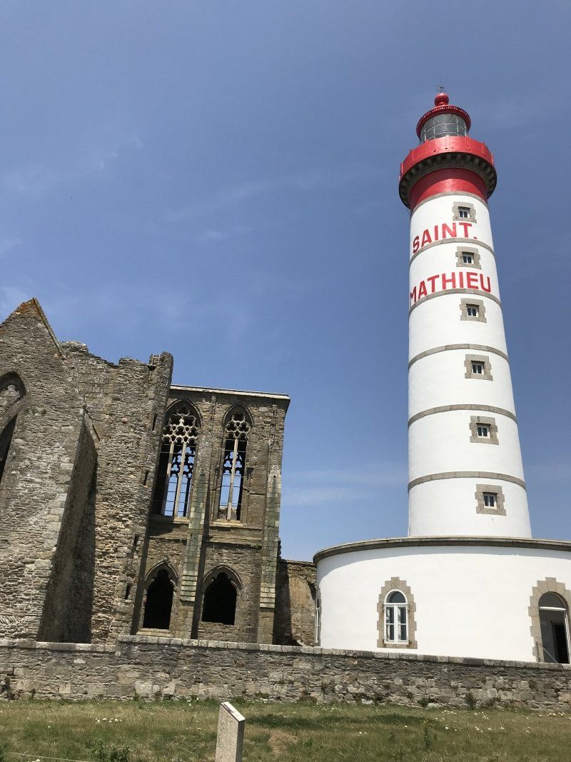
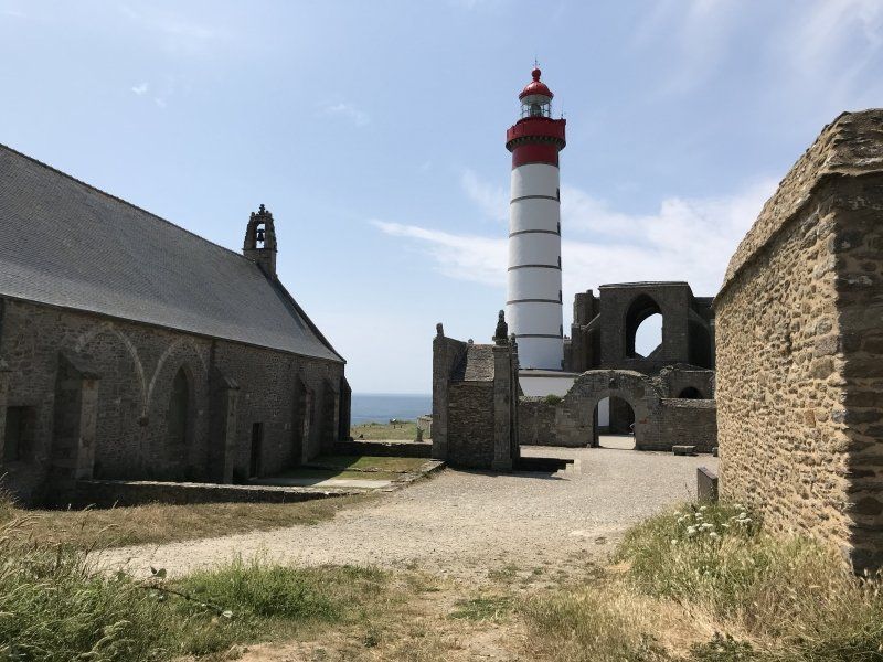
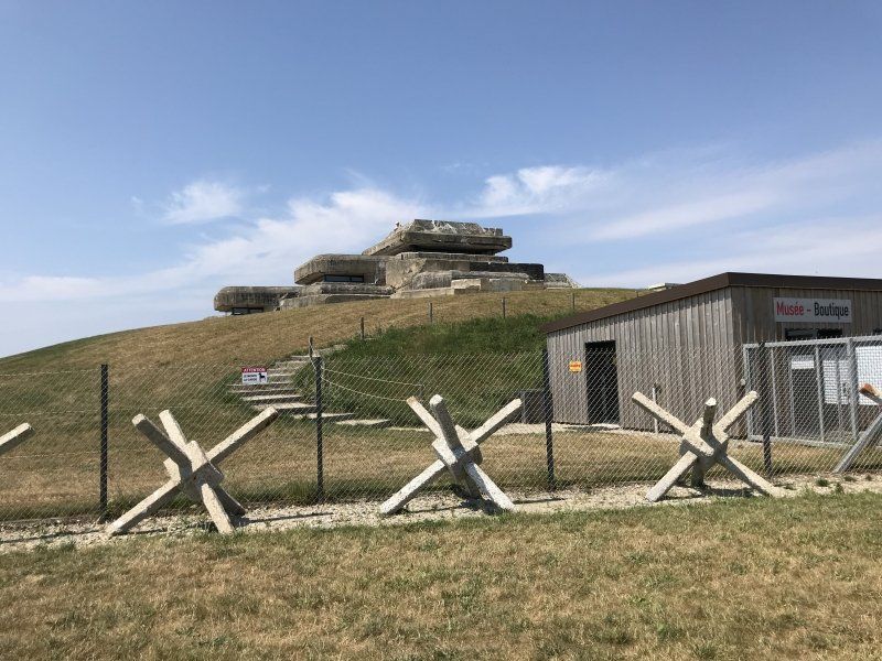
A bike trip to St. Mathieu is worthwhile. Also worth seeing is a German bunker on the Atlantic Wall with a history museum. The facility is located near St. Mathieu
Route de la Presqu'île Kermorvan, 29217 Le Conquet, Frankreich
48° 22' 2.3" N 4° 45' 34.9" W
48.3673125 -4.7596979
• Head toward Route de Kermorvan. Go for 19 m.
• Turn right onto Route de Kermorvan. Go for 1.3 km.
• Turn slightly right toward D28. Go for 41 m.
• Turn left onto D28. Go for 3.8 km.
• Turn left onto Rue du Stade (D28). Go for 102 m.
• Take the 3rd exit from Rond-Point de la Paix roundabout onto Rue du Stade Huon de Kermadec (D28). Go for 3.3 km.
• Take the 1st exit from roundabout onto Route de Trézien (D28). Go for 6.3 km.
• Turn left onto Lieu-dit Les Buissonnets (D27/D28). Go for 5.9 km.
• Arrive at Rue du Port (D27). Your destination is on the right.
☍
20,7 km
( 24 min.)
Porspoder, Frankreich
10 Route de Melon, 29840 Porspoder, Frankreich
48° 29' 15.6" N 4° 46' 14.5" W
48.4876677 -4.7706848
• Head toward Streat Kerveoc on Rue du Port (D27). Go for 2.7 km.
• Pass 2 roundabouts and continue on Rue de l'Europe (D27). Go for 6.5 km.
• Arrive at Route de Kérarzal (D27).
☍
9,2 km
( 10 min.)
Landunvez, Frankreich
10 D27, 29840 Landunvez, Frankreich
48° 32' 48.6" N 4° 42' 30.1" W
48.5468369 -4.7083502
• Head toward Route du Viaduc on Route de Kérarzal (D27). Go for 302 m.
• Take the 1st exit from roundabout onto Lieu-dit Kersaint (D27). Go for 794 m.
• Take the 1st exit from Rond-Point de Bar al Lan roundabout onto Rue de Kersaint (D168). Go for 1.8 km.
• Pass 2 roundabouts and continue on Avenue de Portsall (D168). Go for 810 m.
• Take the 1st exit from roundabout onto Rue Joseph Lusven (D168). Go for 470 m.
• Turn left onto Rue de l'Arvor (D26). Go for 183 m.
• Take the 1st exit from roundabout onto Rue Docteur Amédée Le Meur. Go for 34 m.
• Take the 1st exit from roundabout onto Rue Docteur Amédée Le Meur. Go for 367 m.
• Turn left onto Rue Jules Fortin (D28). Go for 184 m.
• Continue on D28. Go for 25 m.
• Continue on Route de Lannilis (D28). Go for 2.8 km.
• Take the 2nd exit from roundabout onto D28. Go for 8.0 km.
• Take the 1st exit from Giratoire An Dourig roundabout onto Rue Jean Laot (C17). Go for 506 m.
• Continue on Lieu-dit Milin al Lenn (C17). Go for 138 m.
• Continue on C17. Go for 31 m.
• Continue on Lieu-dit Mesmerchou (C17). Go for 362 m.
• Continue on C17. Go for 56 m.
• Turn right onto Lieu-dit Kerveur (D113). Go for 320 m.
• Turn left onto D113. Go for 319 m.
• Take the 3rd exit from Giratoire Lessiec roundabout onto D13. Go for 843 m.
• Take the 2nd exit from Giratoire de l'Image roundabout onto D13. Go for 825 m.
• Take the 2nd exit from roundabout onto D13. Go for 3.2 km.
• Take the 2nd exit from roundabout onto D13. Go for 755 m.
• Continue on D10. Go for 8.3 km.
• Pass 3 roundabouts and continue on Rue de la Côte des Légendes (D10). Go for 3.5 km.
• Turn left onto Rue Saint-Brevalaire. Go for 235 m.
• Turn left onto Rue Saint-Brevalaire. Go for 52 m.
• Turn right onto Rue de l'Arvor (C4). Go for 953 m.
• Continue on Hent Avel Norzh. Go for 38 m.
• Turn left onto Hent Avel Walarn. Go for 978 m.
• Continue on Rue de la Chaumière. Go for 593 m.
• Turn right onto Route du Bendin. Go for 355 m.
• Arrive at Route du Bendin. Your destination is on the left.
☍
38,3 km
( 41 min.)
Day
Aire de Camping-Car de Meneham
Meneham is an old settlement and now it's kind of an open-air museum. The area and coast are very beautiful.
29890 Kerlouan, Frankreich
48° 40' 2.7" N 4° 21' 54.7" W
48.6674133 -4.3651986
• Head southwest on Route du Bendin. Go for 355 m.
• Turn left onto Rue de la Chaumière. Go for 593 m.
• Continue on Route de Meneham. Go for 978 m.
• Turn right onto Hent Avel Norzh. Go for 7 m.
• Turn left onto Hent Avel Reter (C4). Go for 396 m.
• Continue on Route de Piscavaloc. Go for 1.6 km.
• Turn right onto D770. Go for 341 m.
• Continue on Lieu-dit Menmeur (D770). Go for 186 m.
• Continue on D770. Go for 160 m.
• Continue on Lieu-dit La Gare (D770). Go for 356 m.
• Continue on D770. Go for 756 m.
• Take the 3rd exit from Giratoire Roudouan roundabout onto D10. Go for 1.2 km.
• Take the 1st exit from roundabout onto D10. Go for 1.3 km.
• Take the 2nd exit from roundabout onto D125. Go for 2.1 km.
• Turn left onto Rue de la Mer. Go for 307 m.
• Continue on Rue Saint-Didier. Go for 85 m.
• Turn left onto Rue de Pen Ar Valy (D74). Go for 444 m.
• Continue on Rue de Pen-Ar-Valy (D74). Go for 180 m.
• Continue on Lieu-dit Boulvas Huella (D74). Go for 16 m.
• Continue on D74. Go for 665 m.
• Continue on Lieu-dit Créach Cunval (D74). Go for 192 m.
• Continue on D74. Go for 824 m.
• Continue on Lieu-dit Coatiguinou (D74). Go for 2.0 km.
• Continue on D74. Go for 1.2 km.
• Continue on Lieu-dit Lescoat Morizur (D74). Go for 108 m.
• Continue on D74. Go for 172 m.
• Continue on Lieu-dit Prat Guen (D74). Go for 127 m.
• Continue on D74. Go for 80 m.
• Continue on Rue des Écoles (D74). Go for 308 m.
• Turn left onto Rue de Landivisiau (D32). Go for 14.0 km.
• Take the 2nd exit from roundabout onto Chemin de Landivisiau à Lesneven (D32). Go for 1.4 km.
• Take the 4th exit from Rond-Point de la Croix des Maltotiers roundabout onto D32 toward Brest/Morlaix/Lesneven/Plouescat/Bodilis/Saint-Servais/Saint-Derrien/Z.A. Croix des Maltotiers. Go for 219 m.
• Take ramp onto N12 toward Morlaix. Go for 24.9 km.
• Take ramp toward Morlaix-Centre. Go for 405 m.
• Take the 3rd exit from Rond-Point du 19 Mars 1962 roundabout onto D786 toward Morlaix-Centre. Go for 631 m.
• Take the 1st exit from Rond-Point La Vierge Noire roundabout onto Rue du Cosquer (D46). Go for 686 m.
• Pass 2 roundabouts and continue on Route de Morlaix à Plougasnou (D46). Go for 12.4 km.
• Take the 3rd exit from roundabout onto Route de Kervescontou (D46). Go for 797 m.
• Take the 2nd exit from roundabout onto Route de Saint-Nicholas (D46). Go for 1.7 km.
• Take the 2nd exit from roundabout onto Route de Primel Trégastel (D46). Go for 1.2 km.
• Take the 1st exit from roundabout onto Route de Primel Trégastel (D46). Go for 29 m.
• Continue on Rue de Rhun Predou (D46). Go for 975 m.
• Continue on Rue du Grand Large (D46). Go for 270 m.
• Turn left onto Rue de Karreg An Ti. Go for 208 m.
• Continue on Rue de Karreg An Ti. Go for 95 m.
• Arrive at Rue de Karreg An Ti. Your destination is on the right.
☍
76,9 km
(1 hrs. 4 min.)
Day
Day
Day
Camping municipal de la Mer
The campsite is on the outskirts of Primel Tregastel. Basic food and fresh bread are available at the campsite. There are restaurants in the village, otherwise not much is going on.
15 Rue de Karreg an Ti, 29630 Plougasnou, Frankreich
48° 42' 54.2" N 3° 48' 54.8" W
48.7150628 -3.8152170
• Head southeast on Rue de Karreg An Ti. Go for 303 m.
• Turn right onto Rue du Grand Large (D46). Go for 270 m.
• Continue on Rue de Rhun Predou (D46). Go for 975 m.
• Continue on Route de Primel Trégastel (D46). Go for 8 m.
• Take the 2nd exit from roundabout onto Route de Primel Trégastel (D46). Go for 1.2 km.
• Take the 1st exit from roundabout onto Route de Saint-Nicholas (D46). Go for 1.7 km.
• Take the 2nd exit from roundabout onto Route de Kervescontou (D46). Go for 748 m.
• Take the 2nd exit from roundabout onto Route du Lanmeur (D78). Go for 6.5 km.
• Turn right onto Rue de Locquirec (D64). Go for 1.8 km.
• Take the 3rd exit from Giratoire de Kervoac roundabout onto Lieu-dit Lescorre (D786) toward Lannion/Plestin les G. Go for 6.5 km.
• Pass 5 roundabouts and continue on Route de Morlaix (D786). Go for 14.9 km.
• Take the 4th exit from Rond-Point du Bel Air roundabout onto Boulevard Pierre Mendès France (D786) toward Lannion. Go for 1.9 km.
• Take the 2nd exit from roundabout onto Pont Viarmes (D786) toward Perros-Guirec. Go for 75 m.
• Take the 1st exit from roundabout onto Quai de Viarmes (D786) toward Centre Ville. Go for 177 m.
• Take the 1st exit from roundabout onto Boulevard Pierre Mendès France (D786) toward Centre Ville. Go for 70 m.
• Take the 1st exit from roundabout onto Avenue Ernest Renan toward Tréguier/Centre Ville. Go for 177 m.
• Continue on Rue Jeanne d'Arc. Go for 216 m.
• Continue on Place du Marchallac'h. Go for 24 m.
• Continue on Rue de Tréguier. Go for 524 m.
• Take the 3rd exit from roundabout onto Rue de Tréguier. Go for 350 m.
• Continue on Rue de Saint-Marc. Go for 81 m.
• Pass 2 roundabouts and continue on Rue de Saint-Marc. Go for 482 m.
• Take the 3rd exit from Rond-Point de la Chapelle roundabout onto Rue de Saint-Marc. Go for 156 m.
• Take the 3rd exit from roundabout onto Rue de Saint-Marc (D786). Go for 11.1 km.
• Take the 3rd exit from roundabout onto Pont Losquet (D786). Go for 1.7 km.
• Arrive at D786. Your destination is on the right.
☍
51,8 km
( 51 min.)
Minihy-Tréguier, Frankreich
D786, 22220 Minihy-Tréguier, Frankreich
48° 46' 3.7" N 3° 16' 30.6" W
48.7677000 -3.2751681
• Head northeast on D786. Go for 2.2 km.
• Take the 3rd exit from roundabout onto Route de Lannion (D786). Go for 414 m.
• Take the 2nd exit from roundabout onto Lieu-dit La Corderie (D786). Go for 306 m.
• Keep right onto Chemin de la Corderie (D786). Go for 583 m.
• Take the 3rd exit from roundabout onto Boulevard Jean Guéhenno (D786). Go for 1.2 km.
• Take the 1st exit from roundabout onto D786. Go for 2.1 km.
• Pass 4 roundabouts and continue on Avenue du Trégor (D786). Go for 11.4 km.
• Take the 4th exit from roundabout onto D786. Go for 1.4 km.
• Take the 2nd exit from roundabout onto D7. Go for 5.5 km.
• Take ramp toward Yvias/Pléhédel/Lanleff/Plouézec. Go for 163 m.
• Take the 4th exit from roundabout onto D79. Go for 226 m.
• Take the 1st exit from roundabout onto D79. Go for 775 m.
• Continue on Lieu-dit Quistillic (D79). Go for 153 m.
• Continue on Lieu-dit Kermenguy Poulard (D79). Go for 335 m.
• Continue on D79. Go for 242 m.
• Continue on Rue de la Goélette (D79). Go for 804 m.
• Turn slightly right onto Rue Saint-Fiacre (D21). Go for 163 m.
• Take the 1st exit from roundabout onto Rue Saint-Fiacre (D21). Go for 295 m.
• Continue on Allée de Roudou Hellou (D21). Go for 334 m.
• Continue on D21. Go for 91 m.
• Continue on Lieu-dit Pen Ar Hoat (D21). Go for 29 m.
• Continue on Route de Plouha (D21). Go for 512 m.
• Continue on Lieu-dit La Justice (D21). Go for 84 m.
• Continue on Lieu-dit Saint-Michel (D21). Go for 793 m.
• Continue on D21. Go for 61 m.
• Continue on Lieu-dit Kergrec'h (D21). Go for 72 m.
• Continue on D21. Go for 736 m.
• Continue on Kermaria (D21). Go for 281 m.
• Continue on Lieu-dit Kermaria (D21). Go for 156 m.
• Continue on Lieu-dit Kermaria. Go for 7 m.
• Continue on D21. Go for 2.3 km.
• Continue on Rue de Kermaria An Isquit (D21). Go for 770 m.
• Turn left onto Avenue Laënnec (D21). Go for 242 m.
• Take the 1st exit from roundabout onto Rue René Cassin (D786). Go for 1.3 km.
• Take the 2nd exit from roundabout onto Rue Charles Le Goffic (D786). Go for 2.3 km.
• Arrive at D786. Your destination is on the right.
☍
38,3 km
( 36 min.)
Plouha, Frankreich
D786, 22580 Plouha, Frankreich
48° 39' 55.3" N 2° 53' 35.2" W
48.6653731 -2.8931048
• Head toward Lieu-dit La Lande Mergat on D786. Go for 2.6 km.
• Pass 4 roundabouts and continue on Boulevard du Général de Gaulle (D786). Go for 6.9 km.
• Take the 3rd exit from Rond-Point des Prés Calans roundabout onto D786. Go for 6.9 km.
• Pass 2 roundabouts and continue on D786. Go for 2.6 km.
• Take ramp onto N12 toward St-Brieuc/Rennes/Loudéac/Port du Légué. Go for 14.4 km.
• Take ramp toward Pléneuf-Val-André. Go for 191 m.
• Take the 5th exit from Rond-Point de la Ferrère roundabout onto D765 toward St René/Pléneuf-Val-André. Go for 257 m.
• Take the 2nd exit from Rond-Point des Grands Champs roundabout onto D786 toward Pléneuf-Val-André/Église St Gobrien. Go for 3.4 km.
• Pass 6 roundabouts and continue on Route de la Libération (D786). Go for 15.9 km.
• Continue on Rue du 3 Août 1944 (D34) toward Port d'Armor/Erquy. Go for 3.0 km.
• Turn left onto Rue des Évettes. Go for 147 m.
• Turn left onto Avenue de Caroual. Go for 57 m.
• Arrive at Avenue de Caroual. Your destination is on the right.
☍
56,4 km
( 46 min.)
Day
AREA CAMPER Erquy
1 Rue des Evettes, 22430 Erquy, Frankreich
48° 37' 17.5" N 2° 28' 20.3" W
48.6215271 -2.4722993
• Head toward Rue des Hirondelles on Avenue de Caroual. Go for 57 m.
• Turn right onto Rue des Évettes. Go for 147 m.
• Turn left onto Route de Pléneuf (D34). Go for 2.0 km.
• Arrive at Rue Notre-Dame.
☍
2,2 km
( 4 min.)
Erquy, Frankreich
26 D68, 22430 Erquy, Frankreich
48° 37' 39.9" N 2° 27' 27" W
48.6277419 -2.4574988
• Head toward Rue Balino on Rue Notre-Dame. Go for 211 m.
• Continue on Rue du Château d'Eau. Go for 17 m.
• Turn right onto Rue du Château d'Eau (D34). Go for 1.4 km.
• Take the 3rd exit from roundabout onto Rue de Quélard (D786) toward Fréhel/Matignon/Dinard/Plurien/Sables d'Or les Pins/La Bouillie/Cap Fréhel/Fort la Latte. Go for 2.0 km.
• Pass 2 roundabouts and continue on Rue de la Grande Abbaye (D786). Go for 5.4 km.
• Turn left onto Lieu-dit Saint-Aide (D34) toward Plévenon/Cap Fréhel/Fort la Latte. Go for 2.7 km.
• Turn right onto D16 A. Go for 1.2 km.
• Continue on Lieu-dit Les Noës (D16 A). Go for 122 m.
• Continue on D16 A. Go for 293 m.
• Continue on Rue du Château Serein (D16 A). Go for 3.2 km.
• Arrive at Rue de la Latte. Your destination is on the left.
☍
16,4 km
( 20 min.)
Fort la Latte
22240 Plévenon, Frankreich
48° 40' 6" N 2° 17' 5.4" W
48.6683450 -2.2848290
• Head west on Rue de la Latte. Go for 764 m.
• Turn left toward Rue de la Latte/D16 A. Go for 238 m.
• Turn left onto Rue de la Latte (D16 A). Go for 2.3 km.
• Continue on D16 A. Go for 293 m.
• Continue on Lieu-dit Les Noës (D16 A). Go for 122 m.
• Continue on D16 A. Go for 1.1 km.
• Turn left onto Rue du Petit Trécelin (D34). Go for 2.8 km.
• Turn left onto Rue de la Vieille Côte (D786). Go for 6.1 km.
• Turn right onto Place Rioust des Villes Audrains (D786). Go for 3.3 km.
• Take the 1st exit from roundabout onto D786 toward N.D. du Guildo/St Malo. Go for 1.5 km.
• Take the 3rd exit from roundabout onto Rue de la Croix aux Merles (D786) toward Dinard/Ploubalay. Go for 4.4 km.
• Take the 2nd exit from roundabout onto Rue de la Côte d'Émeraude (D768) toward Dinard/Ploubalay. Go for 1.5 km.
• Pass 3 roundabouts and continue on Lieu-dit Brenan (D768). Go for 2.6 km.
• Take the 1st exit from Giratoire de la Côte d'Émeraude roundabout onto Rue du Colonel Pleven (D768) toward Dinard/St Malo/Centre Ville. Go for 407 m.
• Pass 2 roundabouts and continue on Rue du Général de Gaulle (D768). Go for 1.9 km.
• Continue on D168. Go for 4.6 km.
• Take the 2nd exit from roundabout onto Rue de la Ville-Ès-Passants (D168) toward St Malo/Dinard/Rennes/Barrage de la Rance. Go for 6.7 km.
• Continue on D301. Go for 569 m.
• Take the 2nd exit from Rond-Point des Anciens Combattants roundabout onto Rue de la Grande Moinerie (D2) toward St Méloir des Ondes/Z.I. Sud/La Moinerie/Clinique de la Côte d'Émeraude/Parc d'Activités des Mottais. Go for 285 m.
• Take the 2nd exit from roundabout onto D2. Go for 545 m.
• Pass 2 roundabouts and continue on D2. Go for 1.6 km.
• Continue on Lieu-dit Le Haut Salmon (D2). Go for 97 m.
• Continue on D2. Go for 567 m.
• Continue on La Fresne (D2). Go for 29 m.
• Continue on D2. Go for 656 m.
• Continue on Lieu-dit Les Broussettes (D2). Go for 78 m.
• Continue on D2. Go for 556 m.
• Continue on Lieu-dit Les Quatre Chemins (D2). Go for 156 m.
• Continue on D2. Go for 238 m.
• Continue on Lieu-dit Le Pont-Giraut (D2). Go for 112 m.
• Continue on Lieu-dit Les Grandes Landes (D2). Go for 190 m.
• Continue on Lieu-dit Le Champ Prou (D2). Go for 193 m.
• Continue on Lieu-dit Le Petit Champ Prou (D2). Go for 135 m.
• Continue on D2. Go for 198 m.
• Continue on Lieu-dit Le Petit Bouillon (D2). Go for 44 m.
• Continue on Rue d'Émeraude (D2). Go for 352 m.
• Pass 2 roundabouts and continue on Rue d'Émeraude (D2). Go for 616 m.
• Take the 2nd exit from roundabout onto Rue de Bellevue (D74). Go for 131 m.
• Continue on Place du Souvenir. Go for 16 m.
• Turn slightly left onto Place du Souvenir. Go for 107 m.
• Take the 2nd exit from Place du Souvenir roundabout onto Rue de la Baie (D6). Go for 256 m.
• Continue on D6. Go for 206 m.
• Take the 4th exit from roundabout onto D76. Go for 2.2 km.
• Continue on D76. Go for 2.8 km.
• Take the 3rd exit from roundabout onto Rue de la Ville Ballet. Go for 135 m.
• Arrive at Rue de la Ville Ballet.
☍
53,7 km
( 58 min.)
Day
SP Cancale, Frankreich
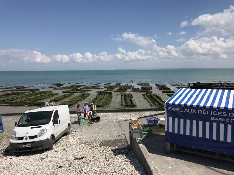
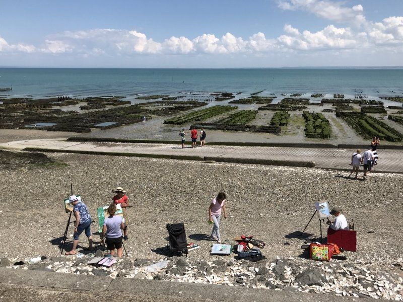
Good parking space above the city for a walk to Cancale. If you love oysters, you've come to the right place. The oyster beds are right in front of the city in the sea.
68 Rue des Français Libres, 35260 Cancale, Frankreich
48° 40' 11.9" N 1° 51' 56.1" W
48.6699798 -1.8655749
• Head toward Rue des Français Libres on Rue de la Ville Ballet. Go for 46 m.
• Turn right onto Rue des Français Libres. Go for 188 m.
• Turn sharp right onto Avenue Olivier Biard (D76) toward Rennes/Mt St Michel/Saint Malo. Go for 241 m.
• Take the 2nd exit from roundabout onto Avenue Olivier Biard (D76). Go for 2.8 km.
• Keep left toward D3076. Go for 756 m.
• Turn right onto D3076. Go for 164 m.
• Turn right onto D155. Go for 5.1 km.
• Take the 2nd exit from roundabout onto Grande Rue (D155). Go for 5.1 km.
• Continue on Rond-Point du Centre (D797). Go for 2.3 km.
• Arrive at Lieu-dit La Laronnière (D797).
☍
16,7 km
( 18 min.)
Day
Cherrueix, Frankreich
33 La Grange Neuve, 35120 Cherrueix, Frankreich
48° 36' 18.4" N 1° 44' 39" W
48.6051071 -1.7441545
• Head toward Chemin Dolais on Lieu-dit La Laronnière (D797). Go for 8.8 km.
• Turn right onto D89. Go for 444 m.
• Turn left onto Lieu-dit Le Bourg (D89). Go for 338 m.
• Continue on D89. Go for 27 m.
• Continue on Lieu-dit le moulin (D89). Go for 27 m.
• Continue on Lieu-dit Le Clos Gauchet (D89). Go for 96 m.
• Continue on D89. Go for 122 m.
• Continue on Lieu-dit La Courpière (D89). Go for 571 m.
• Continue on D89. Go for 2.0 km.
• Turn right onto D89. Go for 767 m.
• Turn left and take ramp onto N176. Go for 9.2 km.
• Continue on N175. Go for 2.6 km.
• Turn left onto Rue d'Enfer. Go for 257 m.
• Take the 2nd exit from roundabout onto Rue de la Saint-Côme (D80). Go for 1.0 km.
• Continue on D80. Go for 991 m.
• Continue on Rue de la Forge (D80). Go for 325 m.
• Turn right onto Rue de Rome (D75). Go for 1.6 km.
• Continue on Route de la Rencontre (D75). Go for 415 m.
• Continue on D75. Go for 210 m.
• Continue on Ruelle de la Chapelle (D75). Go for 844 m.
• Continue on Rue des Arrêts (D75). Go for 47 m.
• Continue on Rue des Marais (D75). Go for 179 m.
• Turn left onto Rue de la Grève (D75). Go for 191 m.
• Continue on Rue des Jardins (D75). Go for 873 m.
• Continue on D107. Go for 9 m.
• Continue on Rue Mont-d'Huisnes (D75). Go for 650 m.
• Turn right onto Rue du Mont Saint-Michel (D75). Go for 309 m.
• Arrive at Rue du Mont Saint-Michel (D75).
☍
32,8 km
( 30 min.)
Courtils, Frankreich
73 Rue du Mont Saint-Michel, 50220 Courtils, Frankreich
48° 37' 31.9" N 1° 26' 39.8" W
48.6255151 -1.4443811
• Head northeast on Rue du Mont Saint-Michel (D75). Go for 6.6 km.
• Take left ramp onto N175 toward Saint-Lô/Caen/Cherbourg/Avranches. Go for 1.8 km.
• Take ramp onto N175. Go for 11.3 km.
• Keep left onto A84 toward Cherbourg/Caen/Saint-Lô/Villedieu-les-Poêles. Go for 54.9 km.
• Take exit 41 toward Caumont-l'Éventé/St Martin des Besaces. Go for 272 m.
• Take the 4th exit from roundabout onto D53 toward Rennes/A84/Caumont-l'Éventé. Go for 199 m.
• Take the 1st exit from roundabout onto D53 toward Sept Vents/Caumont-l'Éventé. Go for 296 m.
• Continue on Lieu-dit Le Parc-Saint-Ouen-des-Besaces (D53). Go for 137 m.
• Continue on D53. Go for 586 m.
• Continue on Lieu-dit La Roque Poret (D53). Go for 90 m.
• Continue on D53. Go for 680 m.
• Continue on Lieu-dit Le Becquet (D53). Go for 127 m.
• Continue on D53. Go for 195 m.
• Continue on Lieu-dit La Hogue (D53). Go for 50 m.
• Continue on D53. Go for 371 m.
• Continue on Lieu-dit La Gare (D53). Go for 157 m.
• Continue on D53. Go for 243 m.
• Continue on Lieu-dit Le Calvaire-St-Jean-des-Essartiers (D53). Go for 105 m.
• Continue on D53. Go for 886 m.
• Continue on Lieu-dit La Lasserie (D53). Go for 99 m.
• Continue on D53. Go for 295 m.
• Continue on Lieu-dit Saint-Laurent (D53). Go for 82 m.
• Continue on D53. Go for 562 m.
• Continue on Lieu-dit Orval (D53). Go for 91 m.
• Continue on D53. Go for 414 m.
• Continue on Lieu-dit La Ferme Neuve (D53). Go for 109 m.
• Continue on Rue de Saint-Martin des Besaces (D53). Go for 403 m.
• Continue on Place de la Mairie (D53). Go for 32 m.
• Continue on Rue de Caumont (D53). Go for 54 m.
• Turn left onto Rue de Caumont (D53). Go for 264 m.
• Continue on Lieu-dit Les Laurents (D53). Go for 92 m.
• Continue on D53. Go for 569 m.
• Continue on Rue de Vire (D53). Go for 973 m.
• Turn right onto Rue Saint-Martin (D9). Go for 145 m.
• Turn left onto Rue de Caen (D9). Go for 6.6 km.
• Turn left onto D187. Go for 930 m.
• Turn left onto Rue de la Belle Épine (D67). Go for 1.4 km.
• Continue on Lieu-dit Le Ruisseau aux Adams (D67). Go for 893 m.
• Continue on D67. Go for 137 m.
• Continue on Lieu-dit Le Hameau aux Landais (D67). Go for 177 m.
• Continue on Lieu-dit Le Pont du Titre (D67). Go for 457 m.
• Continue on D67. Go for 2.1 km.
• Continue on Lieu-dit La Belle Épine (D67). Go for 617 m.
• Continue on D67. Go for 364 m.
• Continue on Lieu-dit La Londe (D67). Go for 149 m.
• Continue on D67. Go for 291 m.
• Continue on Lieu-dit L'Espagne (D67). Go for 180 m.
• Continue on D67. Go for 841 m.
• Continue on Lieu-dit Lieu au Rat (D67). Go for 119 m.
• Continue on D67. Go for 86 m.
• Continue on Lieu-dit Le Rat (D67). Go for 68 m.
• Continue on D67. Go for 282 m.
• Continue on Lieu-dit Clos Pain (D67). Go for 161 m.
• Continue on D67. Go for 1.3 km.
• Continue on Lieu-dit Le Haut Buis (D67). Go for 95 m.
• Continue on D67. Go for 878 m.
• Continue on Lieu-dit Ferme d'Asnelles (D67). Go for 191 m.
• Continue on D67. Go for 456 m.
• Continue on Lieu-dit La Coquerie (D67). Go for 97 m.
• Continue on D67. Go for 1.1 km.
• Continue on Route de la Belle Épine (D67). Go for 2.6 km.
• Continue on D67. Go for 503 m.
• Turn right onto Route de Saint-Lô (D572). Go for 463 m.
• Take the 3rd exit from roundabout onto Boulevard Fabian Ware (D5). Go for 581 m.
• Take the 2nd exit from roundabout onto Boulevard Fabian Ware (D5). Go for 332 m.
• Continue on Boulevard du 6 Juin (D5 A). Go for 197 m.
• Pass 2 roundabouts and continue on Boulevard du 6 Juin 1944 (D5 A). Go for 654 m.
• Take the 2nd exit from Rond-Point de Vaucelles roundabout onto Boulevard d'Eindhoven (D613). Go for 1.2 km.
• Take the 3rd exit from roundabout onto Route de Vaux-sur-Aure (D104). Go for 590 m.
• Take the 2nd exit from roundabout onto Route de Vaux-sur-Aure (D104). Go for 491 m.
• Continue on Route de Bayeux (D104). Go for 1.0 km.
• Continue on D104. Go for 95 m.
• Continue on Lieu-dit Le Parc (D104). Go for 219 m.
• Continue on Lieu-dit L'Entretenant (D104). Go for 113 m.
• Continue on D104. Go for 856 m.
• Continue on Route de Longues-sur-Mer (D104). Go for 420 m.
• Continue on Lieu-dit Fumichon (D104). Go for 744 m.
• Continue on Route de Bayeux (D104). Go for 1.3 km.
• Continue on D104. Go for 61 m.
• Continue on Rue de l'Abbaye (D104). Go for 223 m.
• Continue on Rue de la Mer (D104). Go for 804 m.
• Turn left. Go for 263 m.
• Arrive at your destination on the right.
☍
116,9 km
(1 hrs. 27 min.)
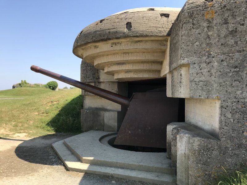
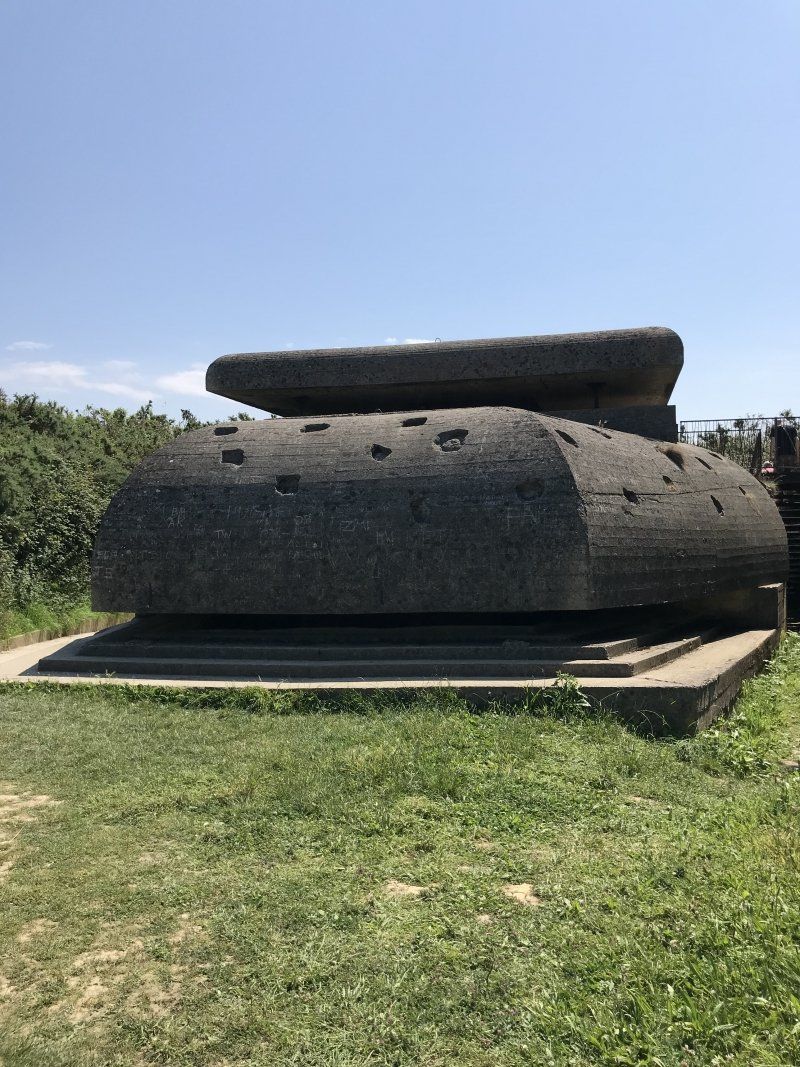
Baterías Alemanas
Artillery position of the German Atlantic Wall. The remains of the Allied landing pontoons can be seen from there.
Francia, 14400 Longues-sur-Mer, Frankreich
49° 20' 36.1" N 0° 41' 35.1" W
49.3433555 -0.6930828
• Head toward Lieu-dit Les Parcs. Go for 456 m.
• Turn left toward Rue Sainte-Mary de Jersey. Go for 537 m.
• Turn left onto Rue Sainte-Mary de Jersey. Go for 284 m.
• Turn right onto Rue Jean-Pierre Savary. Go for 117 m.
• Turn left onto Rue de l'École (D514). Go for 71 m.
• Turn right onto Rue de l'Abbaye (D104). Go for 223 m.
• Continue on D104. Go for 61 m.
• Continue on Route de Bayeux (D104). Go for 1.3 km.
• Continue on Lieu-dit Fumichon (D104). Go for 744 m.
• Continue on Route de Longues-sur-Mer (D104). Go for 420 m.
• Continue on D104. Go for 856 m.
• Continue on Lieu-dit L'Entretenant (D104). Go for 113 m.
• Continue on Lieu-dit Le Parc (D104). Go for 219 m.
• Turn left onto Lieu-dit Hameau le Hutrel (D153). Go for 305 m.
• Turn left onto D153. Go for 1.1 km.
• Turn right onto Route d'Arromanches (D516). Go for 1.7 km.
• Take the 3rd exit from roundabout onto Boulevard Winston Churchill (D613). Go for 438 m.
• Pass 4 roundabouts and continue on Boulevard Winston Churchill (D613). Go for 1.5 km.
• Take the 3rd exit from Rond-Point Eisenhower roundabout onto Rue de Caen (D613). Go for 3.6 km.
• Take the 2nd exit from roundabout onto D33. Go for 351 m.
• Take the 2nd exit from roundabout onto D33. Go for 278 m.
• Take the 3rd exit from roundabout onto N13 toward Caen. Go for 28.9 km.
• Take ramp toward Deauville/Trouville/Rouen. Go for 456 m.
• Keep left onto A13 (Autoroute de Normandie) toward Deauville/Trouville/Le Havre/Rouen/Paris/Troarn/Dozulé. Go for 40.9 km.
• Take the exit toward Trouville/Deauville onto A132. Go for 1.8 km.
• Take the exit toward Le Havre/Honfleur/Aéroport Deauville-Normandie. Go for 368 m.
• Take the 2nd exit from roundabout onto Route de Honfleur (D579) toward Le Havre/Honfleur/Pont de Normandie/Aéroport Deauville-Normandie. Go for 8.7 km.
• Turn left onto Route de Honfleur (D579 A) toward Honfleur-Centre/Équemauville/Centre Hospitalier d'Equemauville. Go for 3.3 km.
• Pass 2 roundabouts and continue on Cours Albert Manuel (D579 A). Go for 3.0 km.
• Turn left onto Rue du Dauphin. Go for 125 m.
• Continue on Place Pierre Berthelot. Go for 69 m.
• Continue on Rue des Logettes. Go for 66 m.
• Turn left onto Place Hamelin. Go for 42 m.
• Continue on Rue Haute. Go for 420 m.
• Continue on Place Jean de Vienne. Go for 209 m.
• Turn right. Go for 24 m.
• Arrive at your destination on the right.
☍
102,9 km
(1 hrs. 17 min.)
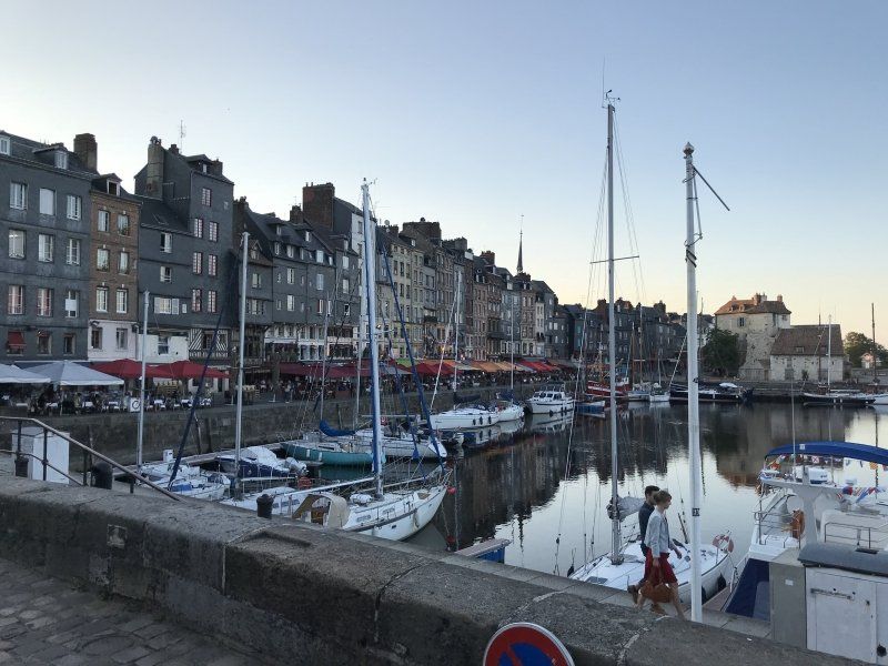
Camping Normandy Sea Lighthouse **
Expensive CP. But the city is worth seeing.
Boulevard Charles V, 14600 Honfleur, Frankreich
49° 25' 29.5" N 0° 13' 34.5" E
49.4248694 0.2262497
• Head north. Go for 114 m.
• Turn slightly left toward Place Jean de Vienne. Go for 109 m.
• Continue on Place Jean de Vienne. Go for 209 m.
• Turn left onto Place Jean de Vienne. Go for 38 m.
• Take the 1st exit from roundabout onto Boulevard Charles V. Go for 410 m.
• Continue on Place Augustin Normand. Go for 63 m.
• Continue on Quai des Passagers. Go for 71 m.
• Turn left onto Quai de la Quarantaine. Go for 228 m.
• Continue on Quai de la Tour. Go for 131 m.
• Take the 4th exit from Rond-Point de la Tour roundabout onto Quai Lepaulmier (D580). Go for 339 m.
• Keep left toward D580. Go for 42 m.
• Pass 2 roundabouts and continue on Cours Jean de Vienne (D580). Go for 1.1 km.
• Take the 3rd exit from roundabout onto D580 toward A29(A13)/Le Havre/Pont-Audemer/Pont de Normandie/Z.I. du Portuaire/Parc Naturel Régional des Boucles de la Seine Normande. Go for 528 m.
• Pass 2 roundabouts and continue on D580. Go for 805 m.
• Take the 3rd exit from roundabout onto A29 toward Le Havre/Pont de Normandie. Go for 493 m.
• Continue on N1029. Go for 7.1 km.
• Continue on A29. Go for 9.9 km.
• Take exit 6 toward St Romain de Colbosc/Étretat. Go for 1.2 km.
• Take the 2nd exit from roundabout onto D39 toward Épretot/Étainhus/Sainneville/Montivilliers/Étretat. Go for 957 m.
• Take the 2nd exit from roundabout onto D39. Go for 128 m.
• Continue on Route d'Étretat (D39). Go for 4.4 km.
• Continue on Chemin d'Étretat à Tancarville (D39). Go for 85 m.
• Take the 2nd exit from roundabout. Go for 868 m.
• Take the 3rd exit from roundabout onto Rue d'Auzouville. Go for 661 m.
• Continue on Rue du Cap (D125). Go for 596 m.
• Continue on Route d'Angerville (D125). Go for 292 m.
• Take the 2nd exit from roundabout onto Route du Village (D125) toward Hermeville/Turretot/Gonneville la Mallet. Go for 1.4 km.
• Continue on D125. Go for 423 m.
• Continue on Route d'Hermeville (D125). Go for 846 m.
• Continue on D125. Go for 269 m.
• Continue on Route d'Hermeville (D125). Go for 1.2 km.
• Continue on Lieu-dit Les Buquets (D125). Go for 87 m.
• Continue on D125. Go for 282 m.
• Continue on Route de Turretot (D125). Go for 520 m.
• Continue on D125. Go for 208 m.
• Continue on Chemin de Gonneville à Beuzeville (D125). Go for 563 m.
• Continue on Rue Léon Delaquerrière (D125). Go for 612 m.
• Turn left onto Rue de la République (D139). Go for 124 m.
• Continue on Rue Pierre Doutreleau (D32). Go for 607 m.
• Continue on Route de Beaurepaire (D32). Go for 840 m.
• Continue on Lieu-dit Le Haut de la Paroisse (D32). Go for 166 m.
• Continue on Route de Gonneville (D32). Go for 687 m.
• Continue on Lieu-dit La Forge (D32). Go for 155 m.
• Continue on Route de Gonneville (D32). Go for 592 m.
• Continue on D32. Go for 37 m.
• Continue on Route de Gonneville (D32). Go for 692 m.
• Turn right onto Route du Havre (D940). Go for 4.0 km.
• Turn left onto Chemin du Petit Valaine. Go for 22 m.
• Turn right. Go for 58 m.
• Arrive at your destination on the right.
☍
45,3 km
( 46 min.)
Day
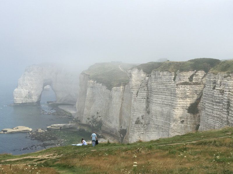
Étretat, Frankreich
We had read about the cliff with the white rocks and wanted to see them. You cannot park in the immediate vicinity because of a huge golf course. So we parked on an SP just outside the village and walked a good half an hour to the coast. And then that: fog or haze! The humid sea air condensed with the hot land air. Still we could see something and then ... it went on.
20 Route du Havre, 76790 Étretat, Frankreich
49° 42' 5.1" N 0° 11' 58.8" E
49.7014062 0.1996581
• Head north. Go for 262 m.
• Continue on Route du Havre. Go for 14 m.
• Turn left onto Route du Havre (D940). Go for 14.0 km.
• Take the 3rd exit from roundabout onto Route d'Étretat (D940). Go for 644 m.
• Take the 2nd exit from roundabout onto Route d'Étretat (D940). Go for 2.6 km.
• Take the 3rd exit from Quai Bérigny roundabout onto Chaussée Gayant (D925). Go for 214 m.
• Turn right onto Quai de la Marne. Go for 96 m.
• Arrive at Quai de la Marne. Your destination is on the right.
☍
17,8 km
( 24 min.)
SP Fécamp, Frankreich
Town square at the harbor. After a tour of the port, we drove on.
Quai de Verdun, 76400 Fécamp, Frankreich
49° 45' 38.4" N 0° 22' 30.4" E
49.7606605 0.3751013
• Head toward Chaussée Gayant on Quai de la Marne. Go for 96 m.
• Turn right onto Chaussée Gayant (D925). Go for 379 m.
• Continue on Route de Cany (D925). Go for 7.2 km.
• Pass 2 roundabouts and continue on D925. Go for 9.6 km.
• Take the 2nd exit from roundabout onto Route de Fécamp (D925) toward Dieppe/St Valery en Caux/Cany-Barville/Clasville. Go for 3.0 km.
• Continue on Rue du Général de Gaulle (D925). Go for 471 m.
• Continue on Rue de Saint-Valéry (D925). Go for 9.8 km.
• Pass 7 roundabouts and continue on Route de Dieppe (D925). Go for 22.2 km.
• Take the 3rd exit from roundabout onto Route de Dieppe (D925) toward Dieppe/Hautot S/Mer. Go for 5.9 km.
• Take the 2nd exit from roundabout onto Route d'Ouville (D925) toward Dieppe/Petit-Appeville. Go for 4.9 km.
• Take the 3rd exit from Rond-Point des Canadiens roundabout onto Rocade de Dieppe (D927) toward Eu/Le Tréport/Neuville les Dieppe. Go for 1.5 km.
• Take the 2nd exit from roundabout onto Avenue de Bréauté toward Dieppe-Port/Neuville-lès-Dieppe. Go for 202 m.
• Take the 2nd exit from roundabout onto Cours Bourbon. Go for 57 m.
• Take the 2nd exit from roundabout onto Cours Bourbon. Go for 284 m.
• Turn left onto Route de Bonne Nouvelle. Go for 1.0 km.
• Continue on Rue Bonne Nouvelle. Go for 236 m.
• Take the 1st exit from roundabout onto Rue Maurice Levasseur. Go for 99 m.
• Continue on Rue Joseph Brunel. Go for 169 m.
• Turn left onto Grande Rue du Pollet. Go for 33 m.
• Turn right onto Quai de la Somme. Go for 128 m.
• Continue on Quai de la Marne. Go for 265 m.
• Arrive at Quai de la Marne.
☍
67,4 km
(1 hrs. 5 min.)
SP Dieppe, Frankreich
Nicht besonders einladend. Für einen Stadtbesuch sicher ausreichend. Gegenüber liegt ein weiterer SP, den wir aber nicht näher untersucht haben.
Quai de la Marne, 76200 Dieppe, Frankreich
49° 55' 50" N 1° 5' 11.1" E
49.9305497 1.0864186
• Head north on Quai de la Marne. Go for 177 m.
• Take the 2nd exit from roundabout onto Quai de l'Avenir. Go for 542 m.
• Take the 1st exit from roundabout onto Rocade des Graves de Mer toward D485/A28/A29. Go for 1.4 km.
• Take the 2nd exit from roundabout onto Rocade des Graves de Mer toward A29/A28. Go for 855 m.
• Take the 1st exit from roundabout onto D925 toward A28/A29/Dieppe/Rouen/Paris. Go for 863 m.
• Take the 2nd exit from roundabout onto D485 toward (Rouen)/Paris/Rouen/Dieppe. Go for 2.2 km.
• Take the 3rd exit from roundabout onto D154 E toward A28/A29/Rouen/Le Havre/Paris/Arques la Bataille. Go for 2.4 km.
• Take the 2nd exit from roundabout onto D54 B toward A28/A29/Paris/Rouen/Le Havre/Torcy/Offranville. Go for 1.9 km.
• Take the 2nd exit from roundabout onto N27 toward A28/A29/Rouen/Le Havre/Paris/Torcy/Tourville S/Arques. Go for 2.1 km.
• Take the 3rd exit from roundabout onto D915 toward A28/Amiens/Paris/Beauvais/Les Grandes Ventes/Torcy. Go for 7.6 km.
• Pass 2 roundabouts and continue on Route de Dieppe (D915). Go for 13.2 km.
• Take the 3rd exit from roundabout onto Route de Paris (D915) toward Bully/Neufchâtel en Bray/A28/Amiens/Beauvais/Paris/Forges les Eaux. Go for 6.9 km.
• Take the 2nd exit from roundabout onto D915 toward Beauvais/Paris/Forges les Eaux. Go for 14.9 km.
• Take the 3rd exit from roundabout onto Route de Rouen (D919) toward Forges les E.-Centre. Go for 2.2 km.
• Turn right onto Boulevard Nicolas Thiéssé. Go for 666 m.
• Arrive at Boulevard Nicolas Thiéssé. Your destination is on the right.
☍
57,9 km
( 52 min.)
Day
Stellplatz Miniere
The SP is opposite the CP Miniere and the fees must also be paid there. Very quiet, asphalted place on the building boundary.
76440 Boulevard Nicolas Thiessé, 76440 Forges-les-Eaux, Frankreich
49° 36' 21.2" N 1° 32' 34.1" E
49.6058954 1.5427932
• Head east on Boulevard Nicolas Thiéssé. Go for 315 m.
• Turn left onto Avenue du 11 Novembre (D921). Go for 833 m.
• Take the 1st exit from roundabout onto Rue Albert Bochet (D915). Go for 587 m.
• Take the 3rd exit from roundabout onto D919. Go for 6.0 km.
• Turn right onto D120. Go for 897 m.
• Continue on Route de Gaillefontaine (D156). Go for 832 m.
• Turn left onto Route de Longuemesnil (D129). Go for 967 m.
• Turn right onto D135. Go for 6.1 km.
• Continue on Rue Principale (D133). Go for 2.9 km.
• Continue on Rue André Picard (D316). Go for 285 m.
• Take the 1st exit from roundabout onto Rue André Picard (D316). Go for 772 m.
• Turn left onto Rue des Prairies (D133). Go for 10.1 km.
• Turn right onto Rue du Maréchal de Boufflers (D133). Go for 14.2 km.
• Take the 3rd exit from roundabout. Go for 705 m.
• Continue toward D901. Go for 38 m.
• Take the 3rd exit from roundabout onto D901 toward A1/Beauvais. Go for 9.7 km.
• Take ramp toward Clermont. Go for 206 m.
• Take the 5th exit from roundabout onto D931 toward Clermont. Go for 471 m.
• Take the 1st exit from roundabout onto N31 toward Creil/Compiègne/Reims/Mouy/Clermont. Go for 31.5 km.
• Take the 1st exit from roundabout onto N31 toward Compiègne/Estrées St D./Avrigny/Sacy le Grand/Catenoy. Go for 536 m.
• Take the 2nd exit from roundabout onto N31 toward A1/Compiègne/Estrées St D./Avrigny. Go for 4.3 km.
• Pass 6 roundabouts and continue on N31. Go for 24.1 km.
• Take the 3rd exit from roundabout onto N31 toward Trosly-Breuil. Go for 9.3 km.
• Take the 2nd exit from roundabout onto Rue du Docteur Moussaud (N31) toward Soissons/Reims/Cuise La Motte. Go for 21.1 km.
• Take the 4th exit from roundabout onto D6 toward Pommiers. Go for 1.1 km.
• Continue on Rue Jean Caudron (D6). Go for 142 m.
• Turn right onto Rue Pavée. Go for 150 m.
• Turn right onto Rue du 8 Mai 1945 (D91). Go for 497 m.
• Continue on D91. Go for 1.6 km.
• Continue on Avenue du Bois Roger (D91). Go for 175 m.
• Take the 1st exit from roundabout onto Rue du Pont. Go for 217 m.
• Continue on Boulevard Édouard Branly. Go for 780 m.
• Take the 2nd exit from Rond-Point Victor Hugo roundabout onto Boulevard Henri Martin. Go for 659 m.
• Turn left onto Avenue du Mail. Go for 323 m.
• Arrive at Avenue du Mail. Your destination is on the right.
☍
152,6 km
(2 hrs. 9 min.)
Day
Day
Camping Soissons
The campsite is quietly located on the outskirts of a park. We didn't particularly like the whole region. Well suited for 1 - 2 nights.
Avenue du Mail, 02200 Soissons, Frankreich
49° 23' 34.5" N 3° 19' 36.9" E
49.3929044 3.3269262
• Head toward Rond-Point du Mail on Avenue du Mail. Go for 976 m.
• Take the 2nd exit from roundabout onto Rue Ernest Ringuier toward Centre Ville. Go for 217 m.
• Continue on Rue de la Résistance. Go for 29 m.
• Turn left onto Rue de la Résistance. Go for 96 m.
• Continue on Avenue de l'Aisne. Go for 336 m.
• Turn right onto Boulevard Gambetta (D1). Go for 289 m.
• Take the 2nd exit from Place de la République roundabout onto D1. Go for 213 m.
• Take the 2nd exit from Rond-Point des États-Unis roundabout onto Avenue de Château-Thierry. Go for 447 m.
• Take the 2nd exit from Boulevard du Tour de Ville roundabout onto Avenue de Château-Thierry (D1). Go for 194 m.
• Take the 2nd exit from roundabout onto Route de Fère-en-Tardenois (D6). Go for 23.5 km.
• Take the 2nd exit from roundabout onto Rue de Fère (D2). Go for 796 m.
• Take the 1st exit from roundabout onto Avenue de la Gare (D2). Go for 940 m.
• Keep right onto Rue Émile Moreau (D220). Go for 475 m.
• Turn left onto Rue de la Goutte d'Or (D2). Go for 513 m.
• Keep left onto Rue du Grès (D2). Go for 360 m.
• Take the 1st exit from roundabout onto Rue de Reims (D2). Go for 12.5 km.
• Turn right onto D474. Go for 338 m.
• Continue on Grande Rue (D474). Go for 489 m.
• Turn right onto Route de Saint-Gemme (D474). Go for 122 m.
• Continue on D474. Go for 1.5 km.
• Continue on D406. Go for 426 m.
• Continue on Route de Goussancourt (D406). Go for 541 m.
• Continue on Rue du Pot d'Étain (D406). Go for 242 m.
• Turn left onto Route de Passy (D406). Go for 166 m.
• Continue on D406. Go for 1.2 km.
• Continue on Rue Jean York (D406). Go for 456 m.
• Turn left onto Rue du Point du Jour (D506). Go for 140 m.
• Turn right onto Route de Reims (D980). Go for 3.9 km.
• Take the 2nd exit from roundabout onto Rue de la Barre (D1) toward Vandières/Châtillon S/M. Go for 372 m.
• Arrive at Rue de la Barre (D1). Your destination is on the left.
☍
51,8 km
( 50 min.)
SP Campagner Jaques Copin - Verneuil, Frankreich
Small winery above the Marne with champagne tasting. The SP is free when purchasing. We liked the campus and we carried a box to the living room.
23 Rue de la Barre, 51700 Verneuil, Frankreich
49° 5' 43.3" N 3° 40' 41.3" E
49.0953594 3.6781513
• Head toward Rue du C.B.R. on Rue de la Barre (D1). Go for 340 m.
• Take the 1st exit from roundabout onto Rue de la Tour (D980). Go for 7.4 km.
• Turn left and take ramp onto A4 (Autoroute de l'Est) toward Reims/Metz. Go for 69.9 km.
• Take exit 25 toward St Étienne au Temple/Bar-le-Duc/Châlons en Ch.-Mt Bernard/Suippes onto Échangeur de Saint-Étienne-au-Temple. Go for 626 m.
• Take the 2nd exit from roundabout onto D977 toward Châlons en Ch. Go for 1.7 km.
• Turn left onto Rue de Dampierre (D208) toward St Étienne au Tple/L'Épine. Go for 472 m.
• Continue on D208. Go for 2.5 km.
• Continue on Lieu-dit Melette (D208). Go for 1.6 km.
• Continue on D208. Go for 2.0 km.
• Continue on Rue de la Croisette (D208). Go for 455 m.
• Continue on D208. Go for 22 m.
• Continue on Rue de la Croisette (D208). Go for 92 m.
• Continue on D208. Go for 15 m.
• Turn left onto Avenue du Luxembourg (D3). Go for 290 m.
• Arrive at Avenue du Luxembourg (D3). Your destination is on the right.
☍
87,4 km
( 50 min.)
L'Épine, Frankreich
35 Avenue du Luxembourg, 51460 L'Épine, Frankreich
48° 58' 37.7" N 4° 28' 11.5" E
48.9771401 4.4698504
• Head northeast on Avenue du Luxembourg (D3). Go for 74 m.
• Turn right onto Rue de l'Église. Go for 80 m.
• Turn right onto Rue Émile Barbier (D65). Go for 154 m.
• Turn left onto Avenue du Luxembourg (D3). Go for 238 m.
• Turn right onto D208 toward St Étienne au Temple/Melette. Go for 15 m.
• Continue on Rue de la Croisette (D208). Go for 92 m.
• Continue on D208. Go for 22 m.
• Continue on Rue de la Croisette (D208). Go for 455 m.
• Continue on D208. Go for 2.0 km.
• Continue on Lieu-dit La Chamoiserie (D208). Go for 1.6 km.
• Continue on D208. Go for 2.5 km.
• Continue on Rue de Dampierre (D208). Go for 472 m.
• Turn right onto D977. Go for 1.6 km.
• Take the 1st exit from roundabout onto Échangeur de Saint-Étienne-au-Temple toward Reims/Troyes/Verdun/Metz/Nancy. Go for 100 m.
• Take ramp onto A4 (Autoroute de l'Est) toward Verdun/Metz/Nancy. Go for 137 km.
• Take the exit toward Metz-Centre/Nancy onto A31. Go for 7.6 km.
• Take exit 33 toward Pontiffroy/Nancy. Go for 1.9 km.
• Turn left onto Rue de Paris (N3). Go for 661 m.
• Make a U-Turn onto N3. Go for 49 m.
• Turn right onto Allée de Metz-Plage. Go for 91 m.
• Turn left onto Allée de Metz-Plage. Go for 222 m.
• Arrive at Allée de Metz-Plage. Your destination is on the left.
☍
156,7 km
(1 hrs. 25 min.)
Day
Camping Municipal Metz
Metz, we always wanted to see this city. It was worth it. The old town with its many pubs has a great atmosphere.
Allée de Metz Plage, 57000 Metz, Frankreich
49° 7' 26.9" N 6° 10' 8.9" E
49.1241420 6.1691451
• Head southwest on Allée de Metz-Plage. Go for 222 m.
• Turn right onto Allée de Metz-Plage. Go for 91 m.
• Turn right onto Rue du Pont des Morts (N3). Go for 612 m.
• Turn right onto Rue des Alliés toward Paris/Luxembourg/Strasbourg/Sarrebruck/Z.I. Metz Deux Fontaines. Go for 468 m.
• Keep right onto Rue des Alliés toward Strasbourg/Sarrebruck/Pontiffroy/Metz Actipole/Metz Technopole. Go for 273 m.
• Continue on Pont Éblé (D953). Go for 614 m.
• Continue on N3. Go for 1.4 km.
• Turn left onto Pont Henry de Ranconval (N3) toward Strasbourg/Sarrebruck/Metz-Actipôle/Bellecroix. Go for 199 m.
• Keep right onto Rue Henry de Ranconval (N3) toward A4/Hôpital Militaire Legouest/Strasbourg/Sarrebruck/Metz-Actipôle/Metz-Technopôle/Bellecroix. Go for 35 m.
• Continue on Voie Pénétrante Est 2 (D603). Go for 2.6 km.
• Keep left onto A314 toward Boulay/St Avold/Sarrebruck/Strasbourg/Paris/Luxembourg. Go for 3.8 km.
• Continue on A4 (Autoroute de l'Est). Go for 40.3 km.
• Take the exit toward Forbach onto A320. Go for 14.6 km.
• Continue on A6. Go for 71.9 km.
• Keep right onto Dreieck Kaiserslautern toward Frankfurt a.M./Mainz/Kaisersl.-Centrum/A63. Go for 523 m.
• Continue on A63. Go for 69.8 km.
• Take exit 2 toward Frankfurt a.M./Darmstadt onto A60. Go for 16.7 km.
• Take the left exit toward Köln/Hannover/Würzburg/Frankfurt onto A67. Go for 6.4 km.
• Take exit 1 toward Würzburg/Frankfurt/Flughafen onto A3. Go for 17.5 km.
• Take exit 52 toward Bad Homburg/Frankfurt/Kassel onto A661. Go for 12.4 km.
• Take exit 8 toward Friedberg/Bad Vilbel onto B3. Go for 4.3 km.
• Take ramp onto Homburger Straße toward Bad Vilbel/Nieder-Eschbach/Nieder Erlenbach/Bad Vilbel-Massenheim. Go for 894 m.
• Pass 2 roundabouts and continue on Homburger Straße. Go for 239 m.
• Take the 2nd exit from roundabout onto Kasseler Straße. Go for 101 m.
• Turn right onto Homburger Straße. Go for 131 m.
• Turn left onto Homburger Straße. Go for 9 m.
• Turn right toward Parkstraße. Go for 160 m.
• Turn right onto Parkstraße. Go for 191 m.
• Arrive at Parkstraße. Your destination is on the left.
☍
266,5 km
(2 hrs. 30 min.)
Day
Bad Vilbel, Deutschland
Parkstraße 18, 61118 Bad Vilbel, Deutschland
50° 10' 56.4" N 8° 44' 22.1" E
50.1823356 8.7394805