As the ferries are running again, this tour is scheduled to start at the end of August. Let's see if everything goes as planned... At least the ferry tickets are here now and the new camper (Hymercar free 602, again a 6m car) has finally arrived. And only 5 weeks late ;)
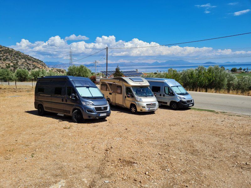
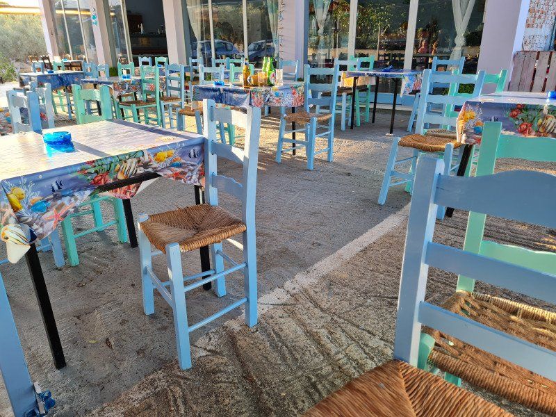
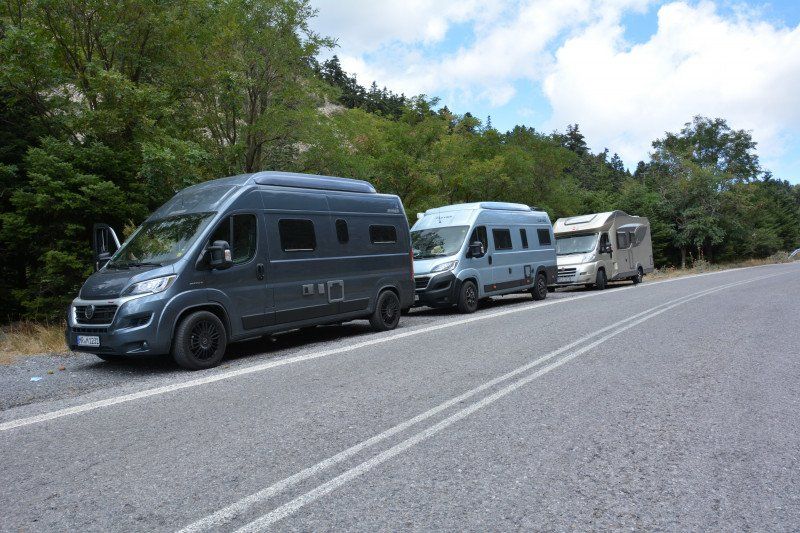
So we got the tour done. After we met the others at Lake Como, we set off with three campers. Comfortable through Italy with less beautiful places on the Adriatic. Unfortunately still quite full. Not just with umbrellas, but also with people. Our overnight stays: SP: Camping Adria in Riccione and CP: Camping Il Pioppeto in Vasto Marina. Arrived in Bari we still had one afternoon until the crossing. We found a great place for the 3 motorhomes/camper vans: Area Hobby Park Wash parking space (Via Carabiniere Giovanni Del Conte). Although very busy because cars are also parked there, but guarded around the clock by super nice employees. There is also a toilet facility. Advantage: You can stay in the city and don't have to hang around at the ferry port. We would also stay there in an emergency.
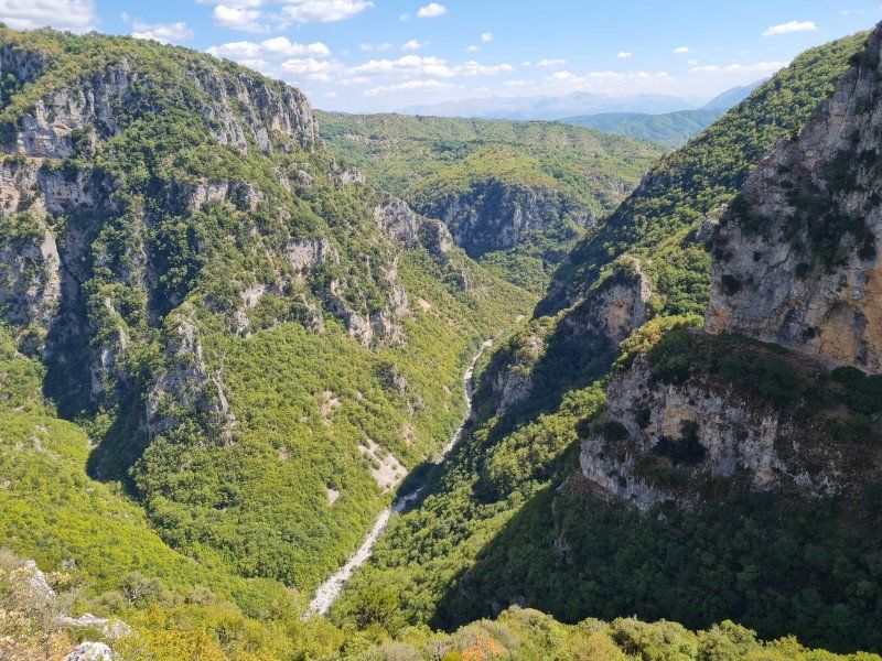
After the pleasant crossing Bari - Igoumenitsa we went directly north with overnight stays in Ioannina (CP: Camping Limnopoula, Kanari 10, Ioannina) and drive to the Vikos Gorge, the narrowest and deepest canyon in the world (at least it said so). Beautiful monastery and very nice restaurant on the platia.
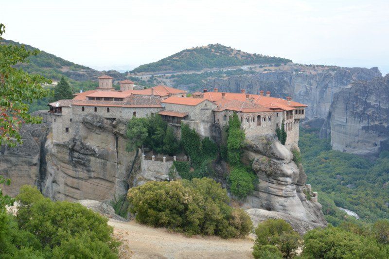
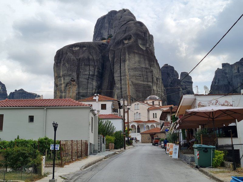
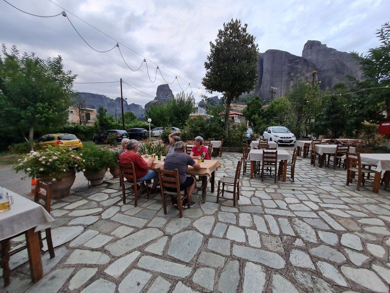
From there to the Meteora monasteries. Hadn't seen our passengers yet, so had to go to the program. Was very impressive again and the campsite was really great (overnight CP: Camping Vrachos in Kastraki - super restaurant on site, great view of the Meteora rocks. Nice little place) By the way: All campsites/parking spaces of the tour are indicated in the route or. most also here in the text.
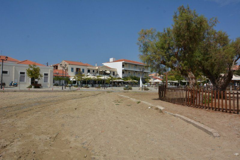
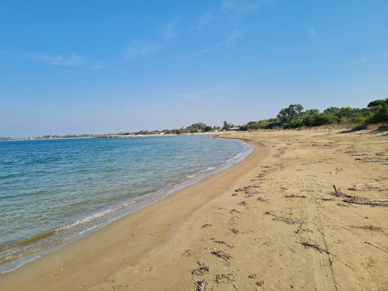
From Meteora then on towards the Peloponnese with an overnight stay at a very nice campsite with really nice operators in Agios Serafim (CP: Camping Venezuela, Paralia Agios Serafim) and on the Argolis. There we first stayed near Corinth (CP: Isthmia Beach Camping, Isthmia Corinth). Even if the place was nice, we wanted to continue and so we continued south on the Peloponnese. Eventually we ended up in Leonidion. Unfortunately, despite excellent reviews, the place was rather mediocre. Small pitches, packed, beach very coarse large gravel. The operator was very nice, but space and only 3 toilets let us continue after one night. Across the finger in the direction of Sparta over a really impressive mountain range with all the switchbacks that a motorcyclist needs and road widths that often forced you to honk your horn before a bend.
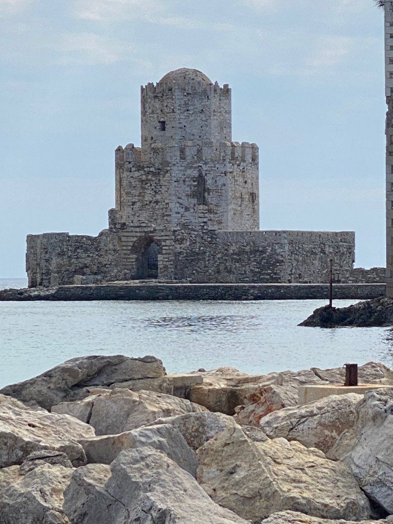
Near Sparta we visited the old monastery town of Mistras. Free in the 70s and 80s, now 12 EUR. Since we had enough switchbacks, the next mountain range was bypassed and we landed in Kalamata to buy the world's best olives (!! sic) The campsite there was not bad, the operator was even extremely nice, but we were drawn to the first finger to Messinia. In the Navarino Bay near Pylos we found a very good campsite with a good restaurant (CP: Erodios Camping, Pylos). The French operators attach great importance to hygiene and cleanliness. Upon arrival, even the body temperature wg. Corona measured. The food was good, but the atmosphere in the restaurant was more like that of a factory canteen or canteen. Luckily, the neighboring town of Navarino Bay can be reached on foot in a few minutes, where you will find plenty of taverns and bars. A detour to Methoni was a must. Firstly they have the best olive oil there, secondly we spent important times there in the 70s and 80s ;)
And then we went back to Patras with a stay at Amaliada (CP: Camping Paradise, Palouki-Amaliada - nice place, great beach). Patras itself is of course unsuitable for stopping, so we drove towards Corinth and looked for the nearest place. From Corinth then the rethinking, we didn't stay there but drove on to Patras after what felt like the 100th visit to the old bridge in the last 40 years. One night before on the coast (CP: Tsolis Camping, Old National Road, Lambiri - great view of the Gulf from above and the mainland opposite, good restaurant, nice operators) and then over the new giant bridge to the mainland. The journey then led along the coast towards Amfilochia and Arta. In contrast to the past, roads are well developed and pleasantly empty. We first drove to Igoumenitsa to visit the campsite there as a waiting destination until the ferry departure. A disaster! We have never seen a more disgusting and filthy place. Although the young operators were really very nice; but unfortunately that's not enough. So back towards Plataria. A place to stay was sought there until the ferry departed from Igoumenitsa.
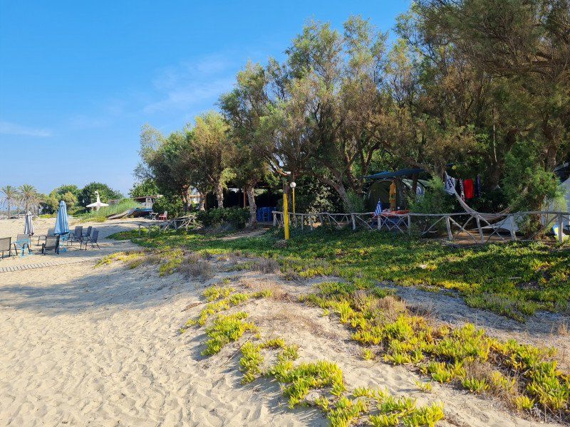
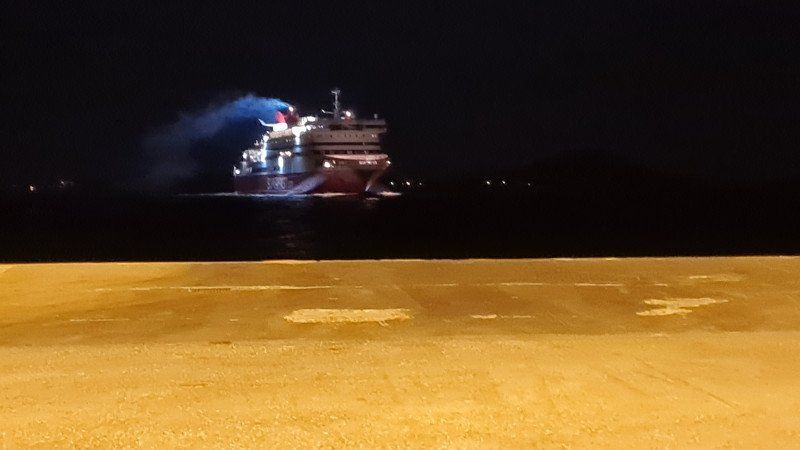
There were three to choose from, Camping Nautilos, Camping Kalami and Camping Elena. Unfortunately Elena was too full so we chose Kalami. The place is run by two sisters whose father "forced" them to learn German as children. Why? Because that's where most visitors come from. The mother cooks, the sea is super clean as usual in Greece and the place is very pleasant. But after two days we had to go back to Igoumenitsa and get on the ferry at night.
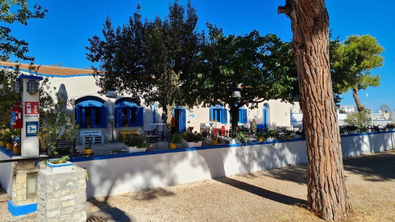
Arrived early in the morning in Bari, we looked for our parking space in the city (see above) and looked for a cafe for breakfast. Then off to Matera, this ancient inland city. A long tour and then back to the coast and north. One night in the almost closed CP Agricampeggio Brezza tri gli Ulivi, (Via Imbriani 441, Bisceglie). Place quite nice, but almost everything is closed, so continue the next day... to the other end of town. And there we met Italy as before. At Camping La Batteria (CP: Camping La Batteria, Panoramica Umberto Paternostro 1 6/1#8, Bisceglie). It was very difficult to swim there, since the rock probably consisted of a concrete slab for military reasons, but we liked the place very much. In the pines some colonies of parakeets (surprisingly quiet). The place is run by some young, very nice and cool people. The restaurant offered a very good typical Italian cuisine from mothers. In addition, the simple setup and music like in the film "Solino". We really liked it!
Unfortunately we had to continue after 2 days. We then found another highlight of a campsite in Bologna. The municipal square there turned out to be super great (CP: Centro Turistico Citta di Bologna, Via Romita 12, Bologna). Since the place is a bit out of the way, it is very quiet. The city is easily accessible by public transport. It's a fairly large area, so there's plenty of space for everyone. Despite this already very good impression, the whole thing was topped. The restaurant! A "revelation". Excellent cuisine at the highest level. Waiters with pronounced wine knowledge, competence and friendliness. We sat in the garden and felt like we were at the noble Italian restaurant in Munich.
Well. It had to go on. So off to the north where pouring rain awaited us behind Milan. So no overnight stay on Lake Maggiore, but continue to Lörrach on the local (expensive) campsite. De was full, so on the associated parking space in front of it. Sanitary facilities and toilets on the CP may not be used. Strange, the parking space is expensive enough. In the end we stayed a few more days in the Black Forest with good weather again (CP: Camping Bankenhof, Bruderhalde 31a, Hinterzarten am Titisee). A bit of hiking and tourism to round off and off you go home.
Overall it was a very nice trip!
And one more thing: Not all places are necessarily listed in the text, but the missing ones are entered in the route description.
Day
Marburg, Deutschland
50° 48' 7.8" N 8° 46' 0.5" E
50.8021728 8.7667933
• Head toward Frankfurter Straße on Haspelstraße. Go for 25 m.
• Turn right onto Frankfurter Straße (K7). Go for 388 m.
• Continue on Am Grün (K7). Go for 329 m.
• Turn right onto Rudolphsplatz (K68). Go for 49 m.
• Turn right onto Weidenhäuser Brücke (L3381) toward Kassel/Gießen/Wehrda. Go for 414 m.
• Turn right and take ramp onto B3 toward Gießen/Cappel. Go for 21.3 km.
• Continue on A485. Go for 6.4 km.
• Take exit 5 toward Gießen-Licher Straße/Gießen-Stadtmitte/Fernwald/Lich. Go for 275 m.
• Turn right onto Licher Straße (B457) toward Büdingen/Lich/Fernwald/Gewerbegebiet Europaviertel/Gewerbegebiet Rivers Automeile. Go for 6.3 km.
• Take ramp onto A5 toward Frankfurt. Go for 81.2 km.
• Take the exit toward Basel/Karlsruhe/Heidelberg onto A5. Go for 287 km.
• Take the exit toward Rheinfelden/Lörrach onto A98. Go for 7.4 km.
• Take exit 5 toward Lörrach-Mitte/Schopfheim/Basel/Weil am Rhein/Lörrach onto B317. Go for 2.3 km.
• Turn left onto Grüttweg. Go for 53 m.
• Continue on Im Grütt. Go for 79 m.
• Continue on Grüttweg. Go for 32 m.
• Turn slightly left onto Grüttweg. Go for 24 m.
• Turn left onto Grüttweg. Go for 66 m.
• Arrive at Grüttweg.
☍
413,6 km
(3 hrs. 37 min.)
Drei-Länder-Camp Campingplatz Lörrach, Grüttweg, Lörrach, Deutschland
Grüttweg 8, 79539 Lörrach, Deutschland
47° 37' 30.1" N 7° 39' 49.7" E
47.6250260 7.6638161
• Head west on Grüttweg. Go for 66 m.
• Turn right onto Grüttweg. Go for 56 m.
• Continue on Im Grütt. Go for 79 m.
• Continue on Grüttweg. Go for 43 m.
• Turn right onto B317. Go for 1.4 km.
• Turn left and take ramp onto A98 toward Rheinfelden. Go for 9.7 km.
• Take exit 7 toward Schweiz/Rheinfelden-Mitte onto A861. Go for 4.6 km.
• Continue on A861. Go for 106 m.
• Continue toward A3. Go for 508 m.
• Take the left exit toward Zürich/Rheinfelden-Ost onto A3. Go for 42.0 km.
• Take the left exit toward Zürich/Baden onto A1/A3. Go for 16.1 km.
• Take exit 59 toward St. Gallen/Flughafen/Nordring-Zürich onto A1/A4. Go for 34.1 km.
• Continue on A1 toward St. Gallen/Kreuzlingen/Winterthur-Ohringen. Go for 82.9 km.
• Continue on A13. Go for 1.2 km.
• Continue on A13. Go for 5.3 km.
• Take exit 3 toward Widnau/Diepoldsau/Heerbrugg. Go for 184 m.
• Take the 4th exit from roundabout onto Diepoldsauerstrasse. Go for 371 m.
• Take the 2nd exit from roundabout onto Diepoldsauerstrasse. Go for 434 m.
• Continue on Tramstrasse. Go for 613 m.
• Continue on Hohenemserstrasse. Go for 1.5 km.
• Continue on Diepoldsauer Straße (L46). Go for 394 m.
• Take the 1st exit from roundabout onto A14 (Rheintal Autobahn) toward Innsbruck/Feldkirch. Go for 39.2 km.
• Continue on Arlberg Schnellstraße (S16). Go for 61.7 km.
• Continue on A12 (Inntal Autobahn). Go for 128 km.
• Take exit 17 toward B178/Felbertauern/Brixental onto Anschlussstelle Wörgl Ost. Go for 1.9 km.
• Continue on Loferer Bundesstraße (B178). Go for 4.0 km.
• Turn right toward Kirchberg/Hopfgarten/Brixental. Go for 138 m.
• Take the 1st exit from roundabout onto Brixental Bundesstraße (B170). Go for 25.1 km.
• Take ramp onto Josef-Pirchl-Straße (B161) toward Lienz/Kitzbühel/Felbertauern/Pass Thurn. Go for 1.5 km.
• Pass 3 roundabouts and continue on Felbertauernstraße. Go for 64.8 km.
• Keep left onto Felbertauern Bundesstraße (B108) toward Lienz. Go for 27.4 km.
• Take the 3rd exit from roundabout onto Albin-Egger-Straße (B100) toward Spittal a.d.Drau. Go for 3.5 km.
• Take the 3rd exit from roundabout toward Nußdorf-Debant/Iselsberg/Großglocknerstr. Go for 147 m.
• Continue on Glocknerstraße (B107a). Go for 80 m.
• Take the 3rd exit from roundabout onto Glocknerstraße (B107a). Go for 1.5 km.
• Take the 2nd exit from roundabout onto Glocknerstraße (B107). Go for 34.1 km.
• Continue on Großglockner Bundesstraße (B107). Go for 334 m.
• Continue on Hof (B107). Go for 1.1 km.
• Continue on Großglockner Bundesstraße (B107). Go for 6.3 km.
• Turn right toward Großglockner Hochalpenstraße. Go for 18 m.
• Take the 1st exit from roundabout. Go for 277 m.
• Continue on Großglockner Hochalpenstraße. Go for 6.6 km.
• Arrive at Großglockner Hochalpenstraße. Your destination is on the right.
☍
609,8 km
(7 hrs. 3 min.)
Großglockner-Hochalpenstraße, Österreich
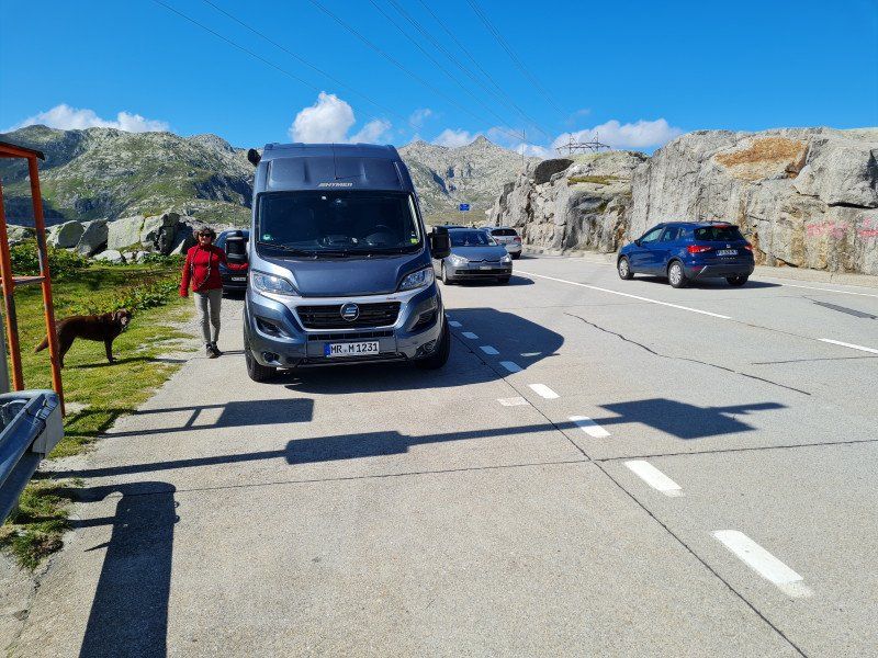
Since the tunnel was totally jammed, we took the pass. very scenic but takes longer and is often quite curvy
Großglockner-Hochalpenstraße, 5661, Österreich
47° 4' 60" N 12° 50' 34" E
47.0833330 12.8427780
• Head south on Großglockner Hochalpenstraße. Go for 6.8 km.
• Continue toward Großglockner Hochalpenstraße. Go for 22 m.
• Take the 2nd exit from roundabout onto Großglockner Hochalpenstraße. Go for 6.1 km.
• Turn left onto Fleiss (L20). Go for 396 m.
• Turn slightly right onto Schachnern (L20). Go for 2.0 km.
• Continue on Schachnern (L20). Go for 424 m.
• Continue on Apriacher Landesstraße (L20). Go for 1.9 km.
• Continue on Apriacher Landesstraße (L20). Go for 3.0 km.
• Turn slightly right onto Mitten (L20). Go for 113 m.
• Continue on Apriacher Landesstraße (L20). Go for 783 m.
• Turn left onto Mitten (L20). Go for 265 m.
• Continue on Döllach (L20). Go for 764 m.
• Turn left onto Döllach (L20). Go for 216 m.
• Turn right onto Döllach. Go for 163 m.
• Turn left onto Döllach (B107). Go for 6.2 km.
• Continue on Großglockner Bundesstraße (B107). Go for 17.8 km.
• Pass 2 roundabouts and continue on Glocknerstraße (B107a). Go for 1.6 km.
• Continue on Glocknerstraße (B107a). Go for 94 m.
• Take the 1st exit from roundabout onto Kärntner Straße (B100). Go for 3.5 km.
• Take the 4th exit from roundabout onto Pustertaler Straße (B100) toward Bozen/Sillian. Go for 33.8 km.
• Continue on Via Bolzano (SS49). Go for 11.8 km.
• Pass 3 roundabouts and continue on Strada Statale della Pusteria (SS49). Go for 7.6 km.
• Keep right toward Strada Statale della Pusteria/SS49. Go for 236 m.
• Continue on Strada Statale della Pusteria (SS49). Go for 3.7 km.
• Take the 3rd exit from roundabout onto Strada Statale della Pusteria (SS49) toward Autobahn/Autostrada/A22/Bruneck/Brunico. Go for 34.3 km.
• Continue on Strada Statale della Pusteria (SS49). Go for 3.5 km.
• Turn right onto Strada Provinciale Rio Pusteria (SP182) toward Mühlbach Zentrum/Rio di Pusteria Centro/Rodeneck/Rodengo/Vals/Valles/Meransen/Maranza. Go for 976 m.
• Turn right onto Via Maranza (SP149). Go for 26 m.
• Turn slightly right onto Strada Provinciale Maranza (SP149). Go for 23 m.
• Turn left onto Via Mathias Perger. Go for 156 m.
• Turn slightly right onto Via Mathias Perger. Go for 150 m.
• Turn slightly left onto Via Zainer. Go for 13 m.
• Turn left. Go for 375 m.
• Turn left. Go for 248 m.
• Keep right toward Mulattiera Naz-Sciaves 1. Go for 652 m.
• Continue on Mulattiera Naz-Sciaves 1. Go for 1.2 km.
• Turn left. Go for 65 m.
• Turn slightly left toward Strada Provinciale Spinga/SP151. Go for 444 m.
• Turn sharp left onto Strada Provinciale Spinga (SP151). Go for 1.4 km.
• Turn slightly left onto Strada Provinciale Spinga (SP151). Go for 597 m.
• Turn right onto Köstental. Go for 728 m.
• Turn left onto Strada Comunale Aica-Spinges. Go for 171 m.
• Continue on Strada Comunale Aica-Spinges. Go for 65 m.
• Turn left onto Strada Comunale Aica-Spinges. Go for 109 m.
• Turn slightly right onto Via Unterdorf. Go for 146 m.
• Turn left onto Strada Provinciale Fortezza-Aica (SP94). Go for 1.3 km.
• Continue on Strada Provinciale Fortezza-Aica (SP94). Go for 189 m.
• Turn right and take ramp. Go for 25 m.
• Take the 1st exit from roundabout onto Strada Statale della Pusteria (SS49bis). Go for 852 m.
• Turn right toward Autobahn/Autostrada/A22/Brixen/Bressanone/Bozen/Bolzano. Go for 141 m.
• Continue on Via Brennero. Go for 106 m.
• Take ramp onto A22 (Autostrada del Brennero) toward Bolzano/Bozen/Modena. Go for 169 km.
• Take the exit toward Affi/Lago di Garda Sud. Go for 598 m.
• Take the 3rd exit from roundabout toward Peschiera/SS450. Go for 337 m.
• Take the 2nd exit from roundabout onto Strada Regionale di Affi (SR450) toward Milano/A4/Peschiera/Verona/SR11. Go for 13.0 km.
• Keep left onto SS11dir toward Milano-Venezia/A4/Brescia/SR11/Sirmione/Peschiera. Go for 3.6 km.
• Take ramp toward Peschiera Centro/Autostrada/A4/Valeggio S/M/SR249. Go for 334 m.
• Take the 2nd exit from roundabout toward Milano-Venezia/A4/Valeggio S/M/SR249. Go for 377 m.
• Continue on Strada Regionale Gardesana Orientale (SR249). Go for 117 m.
• Keep left onto Strada Regionale Gardesana Orientale (SR249) toward Milano-Venezia/A4/Valeggio sul Mincio/Mantova/Verona/SR11/Affi/SR450. Go for 69 m.
• Turn left toward Milano-Venezia/Milano-Brennero/A22. Go for 63 m.
• Take ramp onto A4 (Autostrada della Serenissima) toward Milano. Go for 124 km.
• Take the exit toward Cinisello B./Sesto S.G. Go for 441 m.
• Take ramp onto Viale Brianza (SS36) toward Monza/Lecco. Go for 1.2 km.
• Keep left onto Strada Statale Nuova Valassina (SS36) toward Lecco/Monza/Ospedale San Gerardo. Go for 14.1 km.
• Keep left onto Strada Statale del Lago di Como e dello Spluga (SS36) toward Lecco/Sondrio. Go for 4.2 km.
• Take ramp toward Autostrade/Aeroporto Malpensa/Erba/Arosio/Giussano. Go for 139 m.
• Take the 1st exit from roundabout onto SP102. Go for 1.2 km.
• Continue on Via Alcide De Gasperi toward Mariano C./Novedrate. Go for 747 m.
• Turn right onto Via Artigiani (SP40). Go for 140 m.
• Continue on Via Alessandro Volta (SP40). Go for 1.2 km.
• Take the 3rd exit from roundabout onto Via Alessandro Volta (SP40) toward Brenna. Go for 901 m.
• Continue on SP40. Go for 89 m.
• Continue on Via Valsorda (SP40). Go for 218 m.
• Take the 2nd exit from roundabout onto Via Valsorda (SP40). Go for 869 m.
• Continue on Via Alessandro Manzoni (SP40). Go for 1.1 km.
• Take the 2nd exit from roundabout onto Via Alessandro Manzoni (SP40) toward SS342/Como-Bergamo. Go for 1.5 km.
• Take the 3rd exit from roundabout onto Strada Provinciale Briantea (SPEXSS342) toward Como/SS342. Go for 752 m.
• Take the 3rd exit from roundabout onto Strada Provinciale Briantea (SPEXSS342) toward Como/SS342. Go for 720 m.
• Pass 2 roundabouts. Go for 856 m.
• Continue on Via 4 Novembre (SPEXSS342). Go for 952 m.
• Take the 2nd exit from roundabout onto Via Briantea (SPEXSS342) toward Como/Tavernerio. Go for 370 m.
• Take the 3rd exit from roundabout onto Via Guglielmo Marconi. Go for 619 m.
• Continue on Via Alzate. Go for 183 m.
• Turn left onto Via Alzate. Go for 132 m.
• Arrive at Via Alzate. Your destination is on the right.
☍
501,3 km
(6 hrs. 13 min.)
Day
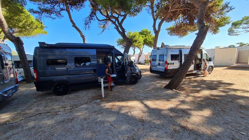
Camping Montorfano Como, Via Per Alzate, Montorfano, Como, Italien
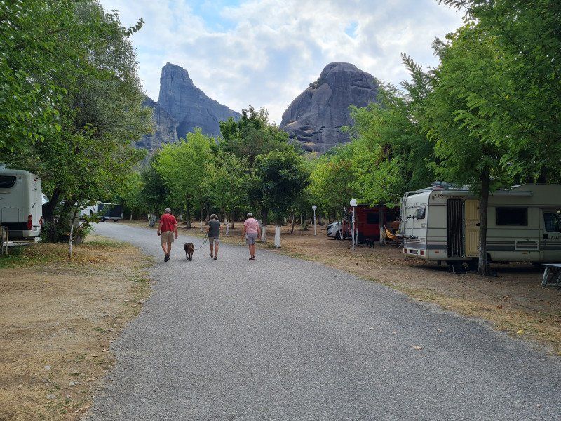
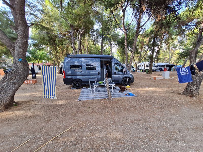
The photo was taken elsewhere (in Greece on the coast of Leonidion), but at least you know which three vehicles we were traveling with
Via Per Alzate, 30, 22030 Montorfano CO, Italien
45° 46' 49" N 9° 9' 35.7" E
45.7802733 9.1599094
• Head northeast on Via Alzate. Go for 132 m.
• Turn right onto Via Alzate. Go for 183 m.
• Continue on Via Guglielmo Marconi. Go for 495 m.
• Take the 1st exit from roundabout onto Via Briantea (SPEXSS342). Go for 425 m.
• Take the 2nd exit from roundabout onto Via Briantea (SPEXSS342) toward Bergamo/Alzate Brianza. Go for 1.0 km.
• Take the 2nd exit from roundabout toward Bergamo. Go for 52 m.
• Continue on Via 25 Aprile. Go for 36 m.
• Continue on Via 4 Novembre (SPEXSS342). Go for 692 m.
• Pass 3 roundabouts and continue on Strada Provinciale Briantea (SPEXSS342). Go for 2.1 km.
• Take the 3rd exit from roundabout onto Via per Como (SPEXSS342) toward Bergamo/SS342. Go for 4.3 km.
• Take the 2nd exit from roundabout onto Strada Provinciale Briantea (SPEXSS342) toward Nibionno Centro/Loc. Mongodio/Milano-Lecco/SS36/Bulciago/SS342/Calco/Bergamo. Go for 404 m.
• Take the 1st exit from roundabout onto Strada Statale del Lago di Como e dello Spluga (SS36) toward Milano. Go for 23.1 km.
• Keep right onto Viale Brianza toward Tangenziale Nord/A52/E35/Bologna/A1/E62/Genova/A7/Aeroporto Linate/Via De Vizzi. Go for 341 m.
• Take ramp onto A52 (Tangenziale Nord) toward Tangenziale Est/A51/E64/Venezia/A4/E35/Bologna/A1/Aeroporto Linate. Go for 6.7 km.
• Continue on A51 (Tangenziale Est). Go for 10.9 km.
• Continue on A1 (Cavalcavia San Donato). Go for 159 km.
• Take the exit toward Modena Nord/Modena Centro/Tangenziale onto Tangenziale Nord Luigi Pirandello. Go for 7.8 km.
• Keep left onto Tangenziale Nord Giosuè Carducci toward Bologna/A1/SS9. Go for 2.3 km.
• Continue on Tangenziale Nord Boris Leonidovic Pasternak. Go for 2.9 km.
• Keep left onto Via Nuova Estense toward Bologna/A1/Abetone/SS12/Vignola/SP623/Ospedale Civile Baggiovara. Go for 1.2 km.
• Take the 3rd exit from roundabout onto Strada Provinciale del Passo Brasa (SP623) toward Bologna/A1/Vignola. Go for 5.1 km.
• Take the 2nd exit from roundabout onto Strada Provinciale del Passo Brasa (SP623) toward Autostrada/A1/Spilamberto/Vignola. Go for 1.7 km.
• Take the 3rd exit from roundabout onto A1 (Autostrada del Sole) toward Bologna. Go for 17.6 km.
• Keep right onto A14 (Autostrada Adriatica) toward Ancona/Ravenna/Padova/A13/Tangenziale/Bologna Borgo Panigale/Bologna Centro/Aeroporto Bologna/Fiera Bologna. Go for 82.1 km.
• Take the exit toward Forlì/Cervia/Cesena/Predappio/Castrocaro Terme/Firenze/Meldola. Go for 449 m.
• Take the 3rd exit from Rotatoria La Pie' roundabout onto Viale della Costituzione toward Centro/Ospedale/Aeroporto. Go for 208 m.
• Turn right toward Cervia. Go for 51 m.
• Continue on Via Antonietta Gordini. Go for 893 m.
• Take the 4th exit from roundabout onto Via Cervese (SS254) toward Cervia/Forlimpopoli/Cesena/SS9. Go for 3.3 km.
• Take the 2nd exit from Rotatoria del Caseificio roundabout onto Via Cervese (SS254) toward Cervia. Go for 7.5 km.
• Continue on Via Bagnolo (SP254). Go for 112 m.
• Continue on Via Bagnolo. Go for 475 m.
• Turn right and take ramp onto Innesto SS16 Adriatica (SS3bis) toward Bologna/A14/Ancona/Roma/Cesena. Go for 5.9 km.
• Take ramp onto A14 (Autostrada Adriatica) toward Ancona/Bologna-Ancona. Go for 42.6 km.
• Take the exit toward Riccione. Go for 697 m.
• Take the 2nd exit from roundabout onto Viale Enrico Berlinguer toward Misano Monte. Go for 441 m.
• Pass 2 roundabouts and continue on Viale Enrico Berlinguer. Go for 565 m.
• Take the 3rd exit from roundabout onto Viale Enrico Berlinguer. Go for 325 m.
• Take the 1st exit from roundabout onto Strada Statale Adriatica (SS16) toward Pesaro. Go for 407 m.
• Take the 3rd exit from roundabout onto Via Circonvallazione (SS16). Go for 264 m.
• Take the 2nd exit from roundabout onto Via Circonvallazione (SS16). Go for 1.0 km.
• Take the 2nd exit from roundabout onto Via Giovanni da Verrazzano. Go for 187 m.
• Pass 2 roundabouts and continue on Via Giovanni da Verrazzano. Go for 706 m.
• Take the 1st exit from roundabout onto Piazzale Marinai d'Italia. Go for 721 m.
• Arrive at Viale Torino. Your destination is on the right.
☍
397,0 km
(3 hrs. 51 min.)
Day
Day
Camping Adria Riccione, Via Torino, Riccione, Rimini, Italien
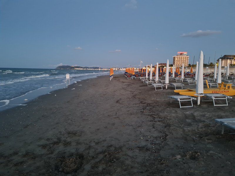
Typical Adriatic coast. Empty Teuton grill, but half of Italy during the day
Via Torino, 40, 47838 Riccione RN, Italien
43° 59' 27.8" N 12° 40' 42.9" E
43.9910588 12.6785767
• Head southeast on Viale Torino. Go for 1.0 km.
• Continue on Via Litoranea Nord. Go for 318 m.
• Take the 1st exit from roundabout onto Via del Mare. Go for 70 m.
• Pass 3 roundabouts and continue on Via del Mare. Go for 579 m.
• Take the 3rd exit from roundabout onto Via del Mare. Go for 79 m.
• Take the 3rd exit from roundabout onto Via Adriatica (SS16). Go for 1.6 km.
• Pass 2 roundabouts and continue on Strada Statale Adriatica (SS16). Go for 2.7 km.
• Turn right onto Svincolo Strada Provinciale 17 toward A14/Cattolica/SP17/S.Giovanni in M./Morciano. Go for 321 m.
• Take the 1st exit from roundabout onto Strada Provinciale Saludecese (SP17) toward Bologna-Ancona/A14/SS17/Morciano di R./S. Giovanni in M. Go for 455 m.
• Take the 4th exit from roundabout onto A14 (Autostrada Adriatica) toward Ancona. Go for 50.8 km.
• Take the exit toward Senigallia. Go for 553 m.
• Take the 1st exit from roundabout toward Pesaro/SS16/Ancona/Ospedale/Aeroporto. Go for 716 m.
• Take the 1st exit from roundabout onto Complanare Sud di Senigallia toward Ancona/SS16/Aeroporto. Go for 4.1 km.
• Take the 1st exit from roundabout onto Strada Statale Adriatica (SS16) toward Aeroporto/Ancona. Go for 8.3 km.
• Take the 2nd exit from roundabout onto Via Marina (SS16). Go for 586 m.
• Turn right onto Via Alessandro Manzoni toward Montemarciano. Go for 118 m.
• Turn left onto Via Gioacchino Rossini. Go for 28 m.
• Turn right onto Via Roma (SP2). Go for 1.7 km.
• Turn slightly left onto Strada Provinciale Sirolo Senigallia (SP2). Go for 1.1 km.
• Take the 2nd exit from roundabout. Go for 116 m.
• Take the 4th exit from roundabout. Go for 446 m.
• Take ramp onto A14 (Autostrada Adriatica) toward Ancona. Go for 247 km.
• Take the exit toward Montenero di Bisaccia/Vasto Sud-San Salvo. Go for 802 m.
• Take ramp onto Strada Fondo Valle del Trigno (SS650) toward Vasto/SS16/Foggia/S. Salvo Marina/Marina di Montenero di B./Pescara. Go for 852 m.
• Take left ramp toward Vasto/Pescara/Ancona. Go for 500 m.
• Continue on Piazzale Verrazzano (SS16). Go for 1.5 km.
• Pass 2 roundabouts and continue on Via SS16 Sud (SS16). Go for 1.8 km.
• Turn right onto Via Maestrale. Go for 119 m.
• Arrive at Via Maestrale.
☍
328,0 km
(3 hrs. 2 min.)
Day
Camping&Residence "Il Pioppeto"
S.S. 16 Sud Km 521, 66054, Vasto Marina, Italy
42° 5' 10" N 14° 44' 22.9" E
42.0861210 14.7397040
• Head toward Via SS16 Sud on Via Maestrale. Go for 119 m.
• Turn left onto Via SS16 Sud (SS16). Go for 631 m.
• Pass 2 roundabouts and continue on Strada Statale Adriatica (SS16). Go for 2.7 km.
• Take ramp onto Strada Fondo Valle del Trigno (SS650) toward Bologna/A14/Bari/Fondo Valle Trigno/S. Salvo/Isernia. Go for 773 m.
• Take ramp toward Ancona/A14/Bari. Go for 364 m.
• Keep left toward Ancona/A14/Bari. Go for 466 m.
• Take left ramp onto A14 (Autostrada Adriatica) toward Bari. Go for 219 km.
• Keep right onto A14 toward Bari Centro/Porto Bari/Brindisi-Lecce/Bari Nord. Go for 4.6 km.
• Take the exit toward Bari Centro/E843/A14/Taranto/Brindisi-Lecce onto SS16 (Tangenziale di Bari). Go for 6.1 km.
• Take ramp onto SS100 toward Bari S. Pasquale/Bari Mungivacca/Ospedale Mater dei Hospital. Go for 454 m.
• Keep left onto Via Giovanni Amendola (SS100). Go for 300 m.
• Take the 1st exit from roundabout onto Via Giovanni Amendola toward Via Amendola. Go for 461 m.
• Take the 3rd exit from roundabout onto Via Giovanni Amendola. Go for 314 m.
• Pass 2 roundabouts and continue on Via Giovanni Amendola. Go for 2.1 km.
• Turn right onto Via Guglielmo Oberdan. Go for 738 m.
• Turn right onto Via Masaniello. Go for 142 m.
• Turn right. Go for 18 m.
• Turn left. Go for 50 m.
• Arrive at your destination on the left.
☍
239,1 km
(2 hrs. 1 min.)
Day
Camper Stop Bari - Autoparco Hobby Park Wash, Bari, Italien
70126 Bari, Italien
41° 6' 57.5" N 16° 53' 6.8" E
41.1159610 16.8852280
• Head east. Go for 50 m.
• Turn right toward Via Masaniello. Go for 18 m.
• Turn right onto Via Masaniello. Go for 31 m.
• Turn left onto Via Peucetia. Go for 643 m.
• Take the 3rd exit from roundabout onto Via Magna Grecia. Go for 273 m.
• Turn right onto Viale Japigia. Go for 835 m.
• Continue on Via Giovanni Gentile. Go for 2.0 km.
• Turn slightly right toward SS16. Go for 702 m.
• Take ramp onto SS16 toward Brindisi. Go for 52.8 km.
• Keep left onto Strada Statale di Egnazia (SS379) toward Brindisi/Lecce/Ostuni. Go for 51.2 km.
• Continue on Strada Statale Adriatica (SS16). Go for 4.4 km.
• Continue on SS613. Go for 813 m.
• Take ramp toward Grecia. Go for 578 m.
• Take the 1st exit from roundabout onto Litoranea Salentina (E55/E90) toward Q.Re Bozzano. Go for 912 m.
• Pass 2 roundabouts and continue on Via Enrico Fermi (E55/E90). Go for 1.1 km.
• Take ramp onto Viale Ettore Maiorana (E55/E90) toward Grecia/Turchia/Costa Morena/Albana. Go for 1.2 km.
• Take the 2nd exit from roundabout onto Via Ettore Maiorana toward Grecia/Turchia/Molo Costa Morena/Molo Punta delle Terrare. Go for 235 m.
• Turn right toward Turchia/Grecia. Go for 399 m.
• Keep right. Go for 402 m.
• Take the Brindisi-Igoumenitsa Ferry. Stay on for 261 km.
• Head northeast. Go for 124 m.
• Continue on E90/E92 (Egnatia Odos). Go for 182 m.
• Take the exit toward Igoumenitsa/Preveza. Go for 152 m.
• Turn left onto Prevezas-Igoumenitsas (E55) toward Igoumenitsa/O/G gia Kerkyra/F/B To Corfu/O/G gia Lefkimmi/F/B To Lefkimmi/O/G gia Paxous/F/B To Paxos. Go for 115 m.
• Turn left onto Agion Apostolon (6) toward Neos Limenas/New Port/O/G gia Kerkyra/O/G gia Lefkimmi/O/G gia Paxous/F/B To Corfu/F/B To Lefkimmi/F/B To Paxos. Go for 544 m.
• Take the 2nd exit from roundabout onto Agion Apostolon (6) toward Egnatia Odos/Egnatia Motorway/A2/Syvota. Go for 147 m.
• Arrive at Agion Apostolon (6).
☍
380,8 km
(8 hrs. 14 min.)
Day
Igoumenitsa Ferry Port, E55, Igoumenitsa, Griechenland
E55, Igoumenitsa 461 00, Griechenland
39° 29' 21.4" N 20° 15' 30.1" E
39.4892668 20.2583502
• Head south on Agion Apostolon (6). Go for 473 m.
• Turn left onto Leoforos 49 Martyron toward Ladochori. Go for 49 m.
• Turn right onto Egnatias toward Ladochori. Go for 618 m.
• Turn right toward Ioannina/A2. Go for 57 m.
• Turn right toward Ioannina/A2/Agia Marina. Go for 165 m.
• Turn left and take ramp onto E90/E92 (Egnatia Odos) toward Ioannina. Go for 66.8 km.
• Take exit 5 toward Athina/Arta/Ioannina/Preveza/Spilaio Peramatos/Perama Cave/Mouseio Kerinon Omoiomaton P. Vrellis/Wax Museum P. Vrellis. Go for 258 m.
• Take the 3rd exit from Leoforos Ipeiroton Evergeton roundabout onto Leoforos Ipeiroton Evergeton (E951) toward Ioannina. Go for 3.1 km.
• Pass 2 roundabouts and continue on Leoforos Dodonis (E951). Go for 3.7 km.
• Take the 3rd exit from roundabout onto Leoforos Evergetou Dompoli (E951) toward Nosokomeio Chatzikosta/Hospital/Aerodromio Ioannina/Airport. Go for 819 m.
• Take the 2nd exit from Plateia Omirou roundabout onto Souliou (E951) toward Gen. Nosokomeio/Hospital. Go for 540 m.
• Turn left onto Lamprou Spyrou (E951) toward Aerodromio Ioannina/Airport. Go for 1.3 km.
• Turn right onto Voreiou Ipeirou (E951) toward Aerodromio Ioannina/Airport. Go for 448 m.
• Turn right onto Leoforos Papandreou Georgiou. Go for 42 m.
• Turn left. Go for 107 m.
• Arrive at your destination on the right.
☍
78,5 km
( 55 min.)
Camping LIMNOPOULA, Ioannina, Griechenland
Ioannina 454 44, Griechenland
39° 40' 38.4" N 20° 50' 36.3" E
39.6773386 20.8434210
• Head toward Leoforos Papandreou Georgiou. Go for 107 m.
• Turn right onto Leoforos Papandreou Georgiou. Go for 54 m.
• Continue on 8is Merarchias. Go for 44 m.
• Keep right onto 8is Merarchias (E853). Go for 416 m.
• Take the 3rd exit from roundabout onto Leoforos Grammou (E853) toward Igoumenitsa/Kozani. Go for 1.1 km.
• Pass 3 roundabouts and continue on Ethniki Odos Kozanis-Ioanninon (E853). Go for 15.5 km.
• Turn right onto Ep. Odos 25-Asfakas-Vrysochoriou toward Kentriko Zagori/Charadra Vikou/Vikos Gorge/Central Zagori. Go for 10.4 km.
• Continue on Ep. Odos 26-Afchenas A.-Elafotopou toward Vitsa/Monodendri/Ano Pedina/Kato Pedina/Elafotopos/Aristi. Go for 3.8 km.
• Turn right onto Ep. Odos 28-A. Pedinon-F. Vikou toward Vitsa/Monodendri. Go for 2.8 km.
• Turn slightly left onto Kentriki Odos Vitsas. Go for 169 m.
• Turn slightly right. Go for 369 m.
• Continue toward Ep. Odos 28-A. Pedinon-F. Vikou. Go for 218 m.
• Turn right onto Ep. Odos 28-A. Pedinon-F. Vikou. Go for 7.5 km.
• Turn slightly left. Go for 470 m.
• Arrive at your destination.
☍
42,9 km
( 57 min.)
Day
Day
Vikos-Schlucht, Monodendri, Griechenland
Monodendri 440 07, Griechenland
39° 55' 6" N 20° 44' 52.5" E
39.9183408 20.7479106
• Head toward Ep. Odos 28-A. Pedinon-F. Vikou. Go for 470 m.
• Turn slightly right onto Ep. Odos 28-A. Pedinon-F. Vikou. Go for 7.5 km.
• Turn left. Go for 335 m.
• Turn slightly right toward Ep. Odos 28-A. Pedinon-F. Vikou. Go for 252 m.
• Turn slightly left onto Ep. Odos 28-A. Pedinon-F. Vikou. Go for 169 m.
• Turn slightly right onto Ep. Odos 28-A. Pedinon-F. Vikou. Go for 2.8 km.
• Turn slightly left onto Ep. Odos 28-A. Pedinon-F. Vikou. Go for 90 m.
• Continue on Ep. Odos 26-Afchenas A.-Elafotopou. Go for 14.2 km.
• Turn left onto Ethniki Odos Kozanis-Ioanninon (E853) toward Ioannina. Go for 7.0 km.
• Turn left toward Metsovo/Perama/Kranoula. Go for 43 m.
• Continue on Lykostomo. Go for 7.0 km.
• Continue on Stratigou Katsimitrou. Go for 3.0 km.
• Turn slightly right onto Ioanninon-Metsovou (6). Go for 22.6 km.
• Turn left and take ramp onto E90/E92 (Egnatia Odos) toward Grevena/Metsovo. Go for 31.1 km.
• Take exit 7Β toward Trikala/Athina/6 onto E92. Go for 41.1 km.
• Take the 1st exit from roundabout onto Ethniki Odos Metsovou-Kalampakas (E92). Go for 268 m.
• Turn left toward Leoforos Oik. Patr. Dimitriou A'. Go for 1.1 km.
• Continue on Leoforos Oik. Patr. Dimitriou A'. Go for 3.8 km.
• Continue on Ep. Od. Kalampakas-I. M. Meteoron. Go for 1.1 km.
• Arrive at Ep. Od. Kalampakas-I. M. Meteoron.
☍
143,8 km
(2 hrs. 36 min.)
Day
Day
Meteora Klöster, Kalambaka, Griechenland
Kalambaka 422 00, Griechenland
39° 43' 34.7" N 21° 37' 34.7" E
39.7262996 21.6263096
• Head west on Ep. Od. Kalampakas-I. M. Meteoron.
• Make a U-Turn onto Ep. Od. Kalampakas-I. M. Meteoron. Go for 1.1 km.
• Continue toward Leoforos Oik. Patr. Dimitriou A'. Go for 3.5 km.
• Continue on Leoforos Oik. Patr. Dimitriou A'. Go for 298 m.
• Turn left. Go for 200 m.
• Turn right. Go for 17 m.
• Arrive at your destination on the right.
☍
5,2 km
( 12 min.)
Campsite Vrachos Kastraki, Camping vrachos, Kastraki, Griechenland
Camping vrachos, Καστράκι 422 00, Griechenland
39° 42' 47.9" N 21° 36' 56.8" E
39.7132954 21.6157717
• Head east. Go for 17 m.
• Turn right toward Dimitriou Patr. Go for 484 m.
• Continue on Dimitriou Patr. Go for 23 m.
• Continue on Patriarchou Dimitriou. Go for 294 m.
• Turn right onto Meteoron. Go for 292 m.
• Turn right onto Ioanninon. Go for 303 m.
• Keep right onto Pindou (E92). Go for 661 m.
• Take the 2nd exit from roundabout. Go for 544 m.
• Take the 1st exit from roundabout onto E65 (Aftokinitodromos Kentrikis Elladas) toward Lamia/A3/Lamia. Go for 39.0 km.
• Take exit 8 toward Proastio/Ag. Triada onto Eparchiaki Odos Fanariou-Makrychoriou. Go for 802 m.
• Take the 2nd exit from roundabout onto Eparchiaki Odos Fanariou-Makrychoriou toward Ag. Triada. Go for 553 m.
• Turn left onto Ep. Odos 15-Agnanterou-Mavrovouniou. Go for 941 m.
• Turn right toward Ethniki Odos Karditsas-Trikalon/30. Go for 9.6 km.
• Turn right onto Ethniki Odos Karditsas-Trikalon (30). Go for 552 m.
• Turn left onto Ep. Od. 4-Karditsas-Karditsomagoula toward Karditsa/Karditsomagoula. Go for 2.1 km.
• Turn right onto Kapodistriou. Go for 190 m.
• Turn left onto Lampraki Grigoriou. Go for 291 m.
• Continue on Lampraki Grigoriou. Go for 88 m.
• Turn left onto Taliadourou. Go for 73 m.
• Continue on Karaiskaki. Go for 8 m.
• Turn right onto Ypsilanti. Go for 26 m.
• Turn right onto Megalou Alexandrou. Go for 75 m.
• Arrive at Megalou Alexandrou. Your destination is on the right.
☍
56,9 km
( 41 min.)
Karditsa, Griechenland
Karditsa 431 00, Griechenland
39° 21' 50.5" N 21° 55' 17.1" E
39.3640258 21.9214049
• Head toward Vasiardani on Megalou Alexandrou. Go for 24 m.
• Turn right onto Vasiardani. Go for 60 m.
• Turn right onto Karaiskaki. Go for 115 m.
• Turn right onto Ypsilanti. Go for 962 m.
• Continue on Leoforos Dimokratias. Go for 791 m.
• Continue on Ethniki Odos Karditsas-Lamias (30) toward Athina/Larisa. Go for 5.5 km.
• Keep right onto Ethniki Odos Karditsas-Lamias (30). Go for 68 m.
• Pass 2 roundabouts and continue on Ethniki Odos Karditsas-Lamias (30). Go for 1.1 km.
• Take the 1st exit from roundabout onto E65 (Aftokinitodromos Kentrikis Elladas) toward Trikala/Larisa/Sofades/Lamia. Go for 79.9 km.
• Take the exit onto E65/E75 (Ethniki Odos Athinon-Lamias). Go for 4.0 km.
• Continue on E75 (Ethniki Odos Athinon-Lamias). Go for 12.7 km.
• Take the exit toward Molos/Ag. Triada/Skarfeia/Ag. Serafeim/Regkini/Komnina. Go for 1.1 km.
• Turn right toward Ag. Serafeim/Skarfeia/Komnina. Go for 2.0 km.
• Turn left toward Skarfeia. Go for 1.6 km.
• Turn slightly right. Go for 485 m.
• Take the 3rd exit from roundabout. Go for 589 m.
• Turn right. Go for 1.5 km.
• Turn right. Go for 517 m.
• Turn right. Go for 38 m.
• Turn slightly left. Go for 752 m.
• Turn right toward Lefkes. Go for 750 m.
• Continue on Lefkes. Go for 441 m.
• Arrive at your destination on the right.
☍
115,1 km
(1 hrs. 15 min.)
Camping Venezuela, Kamena Vourla, Agios Serafim, Griechenland
Kamena Vourla, Ag. Serafim 350 09, Griechenland
38° 49' 24.7" N 22° 42' 59.6" E
38.8235218 22.7165509
• Head southeast. Go for 378 m.
• Turn right. Go for 2.7 km.
• Continue straight ahead. Go for 430 m.
• Turn left. Go for 430 m.
• Turn slightly right. Go for 1.0 km.
• Turn left. Go for 6.4 km.
• Continue toward Kam. Vourla. Go for 25 m.
• Take the 2nd exit from roundabout toward Kam. Vourla. Go for 1.1 km.
• Continue toward Ethniki Odos Athinon-Lamias/E75. Go for 1.4 km.
• Take ramp onto E75 (Ethniki Odos Athinon-Lamias) toward Athina. Go for 162 km.
• Take the exit toward Korinthos/Elefsina onto E94 (Attiki Odos). Go for 75.4 km.
• Take exit 10 toward Epidavros/Korinthos/10/Nosokomeio/Hospital. Go for 291 m.
• Turn left onto Korinthou-Epidavrou toward Spetses/Ydra/Ermioni. Go for 4.9 km.
• Turn left onto Palaiou Kalamakiou. Go for 240 m.
• Turn slightly left onto Palaiou Kalamakiou. Go for 437 m.
• Arrive at your destination on the left.
☍
256,8 km
(2 hrs. 28 min.)
Day
Isthmia Beach Camping
5o Km Isthmos Canal - Epidavros, 20100, Palio Kalamaki, Greece
37° 53' 21.9" N 23° 0' 19.6" E
37.8894100 23.0054400
• Head southwest. Go for 25 m.
• Continue on Palaiou Kalamakiou. Go for 652 m.
• Turn right onto Korinthou-Epidavrou (10). Go for 4.9 km.
• Turn left and take ramp onto E94 (Ethniki Odos Athinon-Korinthou) toward Patra/Tripoli/E65. Go for 6.9 km.
• Keep left onto E65 (Komvos 1-Tripolis) toward Tripoli/Kalamata. Go for 22.1 km.
• Take exit 4 toward Arch. Nemea/Nafplio/Mykines/Anc. Nemea/Mycenae. Go for 686 m.
• Turn left onto Argous-Nemeas (66) toward Nafplio/Argos/Mykines. Go for 2.0 km.
• Turn right onto Korinthou-Argous (7) toward Argos/Nafplio/Dervenakia. Go for 6.4 km.
• Turn left toward Mykines/Nafplio. Go for 6.5 km.
• Continue on Ep. Odos 19-Tirynthas-Mykinon. Go for 7.8 km.
• Continue on Ep. Odos Neas Tirynthas-Poulakidas toward Nafplio. Go for 4.1 km.
• Turn left onto Ep. Odos Neas Tirynthas-Poulakidas toward Nafplio/N. Tiryntha/Tolo/Epidavros. Go for 1.4 km.
• Take the 2nd exit from roundabout toward Nafplio. Go for 2.1 km.
• Take the 2nd exit from roundabout toward Epidavros/Tolo/Tolo-Epidavros. Go for 2.3 km.
• Take the 2nd exit from roundabout onto Eparchiaki Odos Nafpliou-Karnezeika toward Drepano/Tolo. Go for 2.6 km.
• Continue on Ep. Odos 6-Lefkakia-Tolo toward Tolo. Go for 2.3 km.
• Take the 2nd exit from roundabout onto Ep. Odos 6-Lefkakia-Tolo toward Tolo/Tolo Beach. Go for 638 m.
• Continue on Eparchiaki Odos Lefkakia-Tolo. Go for 37 m.
• Continue on Ep. Odos 6-Lefkakia-Tolo. Go for 486 m.
• Turn right toward Perifereiakos-Limani/Ring Road-Port. Go for 564 m.
• Continue on Pournara. Go for 1.1 km.
• Turn right. Go for 462 m.
• Arrive at your destination.
☍
76,1 km
( 57 min.)
Day
Xeni Camp & Bungalows
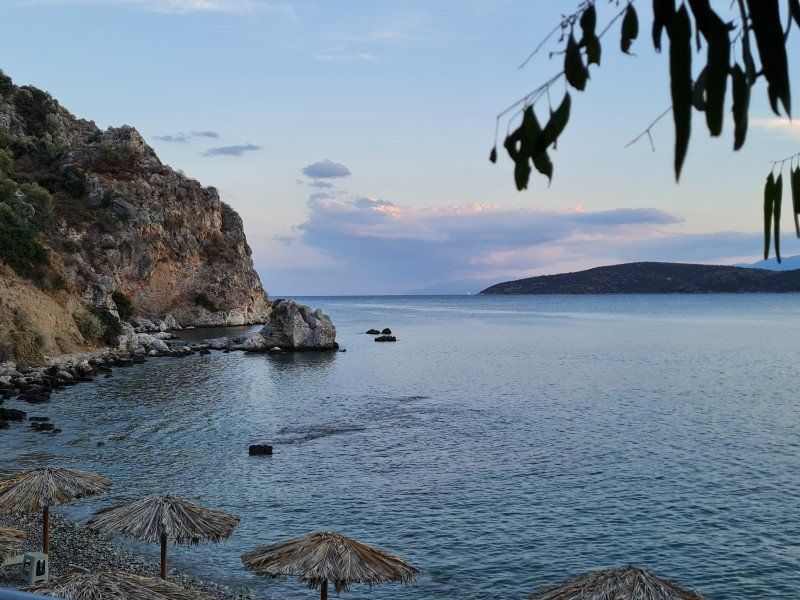
The better restaurant was outside the square, but above all Maria's restaurant in Tolo was great. To reach neighboring village in 500m
Ancient Asini-Tolo Kastraki, 21056, Nafplio, Greece
37° 31' 11.7" N 22° 50' 58.8" E
37.5199300 22.8496700
• Head southeast. Go for 462 m.
• Turn left toward Pournara. Go for 592 m.
• Continue on Pournara. Go for 1.1 km.
• Turn left onto Ep. Odos 6-Lefkakia-Tolo toward Nafplio. Go for 486 m.
• Continue on Eparchiaki Odos Lefkakia-Tolo. Go for 37 m.
• Continue on Ep. Odos 6-Lefkakia-Tolo. Go for 602 m.
• Take the 2nd exit from roundabout onto Leoforos Archaias Asinis toward Asini/Nafplio/Kastraki. Go for 2.3 km.
• Continue on Eparchiaki Odos Nafpliou-Karnezeika toward Nafplio. Go for 2.5 km.
• Take the 3rd exit from roundabout onto Asklipiou (70) toward Nafplio. Go for 3.4 km.
• Take the 2nd exit from roundabout onto Sidiras Merarchias. Go for 491 m.
• Turn right onto Polyzoidou An. toward Teloneio/Customs/Limani/Port/Parkingk/Parking/Athina. Go for 117 m.
• Arrive at Polyzoidou An. Your destination is on the left.
☍
12,1 km
( 16 min.)
Day
Nafplio, Griechenland
37° 34' 2.3" N 22° 48' 5.6" E
37.5673173 22.8015531
• Head north on Polyzoidou An.
• Take the 2nd exit from roundabout onto Ep. Odos 3-Nafpliou-Myloi. Go for 105 m.
• Continue on Eparchiaki Odos Nafplio-Myloi. Go for 131 m.
• Continue on Ep. Odos 3-Nafpliou-Myloi. Go for 1.8 km.
• Continue on Eparchiaki Odos Nafpliou-Myloi. Go for 14 m.
• Continue on Ep. Odos 3-Nafpliou-Myloi. Go for 9.3 km.
• Turn left onto Argous-Tripolis (7) toward Tripoli. Go for 1.8 km.
• Turn left onto Ep. Odos 27-Kiveriou-Xiropigadou toward Astros/Leonidio/Kiveri. Go for 13.6 km.
• Continue on Ep. Odos 14-Kiveriou-Leonidiou. Go for 4.4 km.
• Turn left onto Ep. Odos 14-Kiveriou-Leonidiou toward Paralia Astros/Meligou/Karakovouni/Agios Andreas/Tyros/Leonidio. Go for 2.7 km.
• Continue on Agia Anastasia. Go for 51 m.
• Continue on Ep. Odos 14-Kiveriou-Leonidiou. Go for 45.2 km.
• Turn left onto Ep. Odos 17-Leonidiou-Poulithron. Go for 3.3 km.
• Turn left. Go for 501 m.
• Arrive at your destination on the left.
☍
83,1 km
(1 hrs. 24 min.)
Day
Camping Semeli
22300, Plaka-Leonidion, Greece
37° 8' 57.8" N 22° 53' 31.5" E
37.1493800 22.8920800
• Head northwest. Go for 501 m.
• Turn right onto Ep. Odos 17-Leonidiou-Poulithron. Go for 3.0 km.
• Turn right onto Ep. Odos 17-Leonidiou-Poulithron. Go for 71 m.
• Turn left onto Ep. Odos 15-Leonidiou-Gerakiou. Go for 29.0 km.
• Turn left. Go for 47 m.
• Arrive at your destination on the left.
☍
32,6 km
( 41 min.)
Kosmas, Griechenland
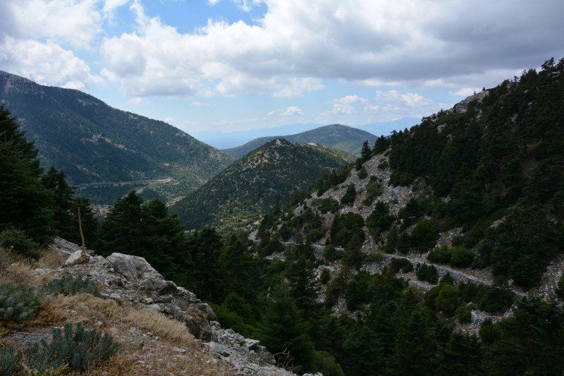
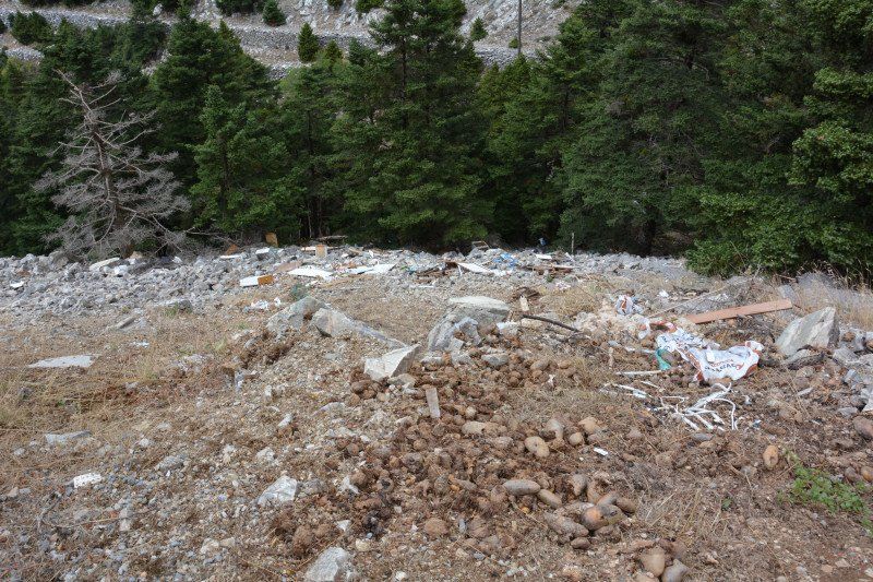
Through the mountains to Sparta. Lots of hairpin bends, great landscape.... but also GARBAGE in the middle of nature. The Greeks stop at nothing.... not as bad as southern Italy, but still unbearable
Kosmas 230 58, Griechenland
37° 5' 33.5" N 22° 44' 25.3" E
37.0926331 22.7403737
• Head northwest. Go for 47 m.
• Turn left onto Ep. Odos 15-Leonidiou-Gerakiou. Go for 15.4 km.
• Continue on Eparchiaki Odos Vrontamas-Skala. Go for 34 m.
• Turn right onto Ep. Odos 4-Spartis-Agiou Dimitriou toward Sparti. Go for 1.4 km.
• Continue on Ep. Odos 4-Spartis-Agiou Dimitriou. Go for 17.3 km.
• Continue on Ep. Odos Spartis-Agiou Dimitriou. Go for 113 m.
• Continue on Ep. Odos 4-Spartis-Agiou Dimitriou. Go for 598 m.
• Continue on Ep. Odos Spartis-Agiou Dimitriou. Go for 48 m.
• Continue on Ep. Odos 4-Spartis-Agiou Dimitriou. Go for 2.8 km.
• Keep right onto Ep. Odos Spartis-Agiou Dimitriou. Go for 217 m.
• Continue on Ep. Odos 4-Spartis-Agiou Dimitriou. Go for 1.5 km.
• Turn right onto Ep. Odos 4-Spartis-Agiou Dimitriou. Go for 7.6 km.
• Turn left onto Lykourgou toward Sparti. Go for 1.7 km.
• Arrive at Lykourgou. Your destination is on the left.
☍
48,7 km
( 44 min.)
Sparta, Griechenland
Sparta 231 00, Griechenland
37° 4' 28.1" N 22° 25' 49" E
37.0744610 22.4302640
• Head west on Lykourgou.
• Turn right onto Palaiologou Konstantinou (E961). Go for 312 m.
• Turn right onto Thermopylon (E961) toward Tripoli/Athina. Go for 620 m.
• Turn left onto Orthias Artemidos (E961) toward Tripoli. Go for 1.1 km.
• Turn right onto Ep. Odos 4-Spartis-Agiou Dimitriou toward Gkoritsa. Go for 508 m.
• Take the 3rd exit from roundabout onto A71 toward Athina/Kalamata. Go for 45.2 km.
• Take the left exit toward Kalamata onto E65 (Ethniki Odos Tripolis-Kalamatas). Go for 41.5 km.
• Continue on A7. Go for 7.5 km.
• Continue straight ahead. Go for 1.6 km.
• Take the 2nd exit from roundabout toward Areopoli-Mani/Areopoli/Mani. Go for 1.7 km.
• Turn right onto Eparchiaki Odos 1-Kalamatas-Areopolis toward Kentro/Center. Go for 977 m.
• Continue on Vasileos Georgiou. Go for 1.0 km.
• Arrive at Vasileos Georgiou. Your destination is on the left.
☍
102,1 km
( 55 min.)
Day
Kalamata, Griechenland
Kalamata 241 00, Griechenland
37° 2' 11.9" N 22° 6' 51.7" E
37.0366386 22.1143716
• Head west on Vasileos Georgiou.
• Turn left onto Faron. Go for 432 m.
• Turn right onto Platonos. Go for 258 m.
• Continue on Makedonias. Go for 573 m.
• Continue on Iroon Polytechneiou (E55/E65) toward Athina/Messini. Go for 5.0 km.
• Turn left onto Kalamatas-Pylou (82) toward Pylos/Messini. Go for 2.5 km.
• Take the 3rd exit from roundabout onto Kalamatas-Pylou (82) toward Pylos/Messini/Aerodromio/Airport. Go for 336 m.
• Take the 2nd exit from roundabout onto Kalamatas-Pylou (82) toward Pylos/Messini. Go for 1.8 km.
• Take the 3rd exit from roundabout onto Kalamatas-Pylou (82) toward Pylos. Go for 25.4 km.
• Turn right onto Eparchiaki Odos Soulinari-Iklaina toward Kremmydia/Glyfada/Iklaina/Koryfasio/Velanidia. Go for 2.5 km.
• Take the 2nd exit from roundabout onto Eparchiaki Odos Soulinari-Iklaina. Go for 7.0 km.
• Continue on Eparchiaki Odos Koryfasi-Iklaina. Go for 4.3 km.
• Turn left onto Kyparissias-Pylou (9). Go for 1.1 km.
• Take the 4th exit from roundabout onto Kyparissias-Pylou (9). Go for 4.9 km.
• Turn right. Go for 731 m.
• Turn left. Go for 152 m.
• Arrive at your destination on the left.
☍
56,9 km
( 56 min.)
Day
Erodios Camping, Pylos, Griechenland
Erodios Camping, Pilos 240 01, Griechenland
36° 57' 7.5" N 21° 41' 42.9" E
36.9520970 21.6952470
• Head west. Go for 20 m.
• Turn right. Go for 90 m.
• Turn left. Go for 34 m.
• Turn right toward Kyparissias-Pylou/9. Go for 731 m.
• Turn right onto Kyparissias-Pylou (9). Go for 4.4 km.
• Turn right onto Methonis-Pylou (9). Go for 4.6 km.
• Turn left onto Methonis-Pylou (9). Go for 8.8 km.
• Turn left onto Eparchiaki Odos Methonis-Foinikounta toward Foinikounta/Koroni. Go for 412 m.
• Turn right. Go for 1.1 km.
• Turn right. Go for 121 m.
• Turn left. Go for 53 m.
• Arrive at your destination on the right.
☍
20,3 km
( 26 min.)
Day
Methoni, Griechenland
Methoni 240 06, Griechenland
36° 49' 11.6" N 21° 42' 22.7" E
36.8199022 21.7063018
• Head south. Go for 41 m.
• Turn right. Go for 25 m.
• Turn left. Go for 257 m.
• Arrive at your destination.
☍
0,3 km
( )
Methoni Castle, Methoni, Griechenland
Unnamed Rd, Methoni 240 06, Griechenland
36° 49' 0.5" N 21° 42' 16" E
36.8168099 21.7044484
• Head southeast. Go for 24 m.
• Turn left toward Miaouli Andrea. Go for 66 m.
• Turn right onto Miaouli Andrea. Go for 92 m.
• Turn slightly left. Go for 518 m.
• Turn left toward Ep. Odos 13-Methoniou-P. Koroniou. Go for 638 m.
• Turn left onto Ep. Odos 13-Methoniou-P. Koroniou. Go for 1.4 km.
• Turn right onto Methonis-Pylou (9) toward Pylos. Go for 8.8 km.
• Turn right onto Kolokotroni (9). Go for 4.6 km.
• Turn left onto Kyparissias-Pylou (9). Go for 9.1 km.
• Take the 2nd exit from roundabout onto Ep. Odos 15-Filiatron-Koryfasiou. Go for 7.1 km.
• Turn left onto Ep. Odos 15-Filiatron-Koryfasiou. Go for 1.2 km.
• Turn right onto Ep. Odos 15-Filiatron-Koryfasiou. Go for 4.8 km.
• Turn right toward Filiatra/Kyparissia. Go for 127 m.
• Continue on Marathopoli. Go for 162 m.
• Continue on Ep. Odos 15-Filiatron-Koryfasiou toward Filiatra. Go for 10.8 km.
• Turn left onto Ep. Odos 15-Filiatron-Koryfasiou (9). Go for 188 m.
• Turn right onto Ethnikis Antistaseos (9). Go for 14.0 km.
• Turn right onto Venizelou Eleftheriou (9). Go for 631 m.
• Turn left onto Melliou (9) toward Kalamata/Pyrgos/Athina. Go for 6.3 km.
• Continue on Ethniki Odos Pyrgou-Kyparissias (E55). Go for 51.1 km.
• Turn right onto Ethniki Odos Pyrgou-Kyparissias (E55) toward Arch. Olympia/Patra. Go for 2.2 km.
• Turn left onto Pyrgou-Archaias Olympias (E55). Go for 9.1 km.
• Take the 4th exit from roundabout onto Ethniki Odos Patron-Pyrgou (E55). Go for 8.8 km.
• Turn left onto Paloukiou toward Palouki. Go for 2.0 km.
• Turn right. Go for 462 m.
• Arrive at your destination on the left.
☍
144,0 km
(2 hrs. 6 min.)
Day
Day
Camping Paradise
27200, Amaliada/Palouki, Greece
37° 45' 26" N 21° 18' 20" E
37.7572200 21.3055500
• Head west. Go for 71 m.
• Turn left. Go for 335 m.
• Turn left toward Paloukiou. Go for 263 m.
• Continue on Paloukiou. Go for 2.0 km.
• Turn left onto Ethniki Odos Patron-Pyrgou (E55). Go for 1.8 km.
• Turn right toward Amaliada. Go for 2.1 km.
• Continue on Petralia Antoniou. Go for 1.2 km.
• Turn right onto Olympias. Go for 37 m.
• Turn left onto Lampeias. Go for 150 m.
• Turn left onto Venizelou Eleftheriou. Go for 313 m.
• Turn right onto Kalavryton. Go for 558 m.
• Turn left onto Daliani Anagn. Go for 170 m.
• Continue on Kalavryton. Go for 944 m.
• Take the 3rd exit from roundabout onto E55 (Olympia Odos). Go for 30.5 km.
• Take the exit. Go for 992 m.
• Take the 2nd exit from roundabout onto Ethniki Odos Patron-Pyrgou (E55). Go for 14.3 km.
• Turn right toward Karaiika/Ag. Nikolaos/Riolos. Go for 37 m.
• Continue on Eparchiaki Odos Karaiika-Riolou. Go for 1.7 km.
• Turn left toward Lampraiika. Go for 2.1 km.
• Continue on Lampraiika. Go for 1.0 km.
• Continue on Veskoukaiika. Go for 2.9 km.
• Turn left toward Eparchiaki Odos Kato Achaias-Arlas. Go for 217 m.
• Turn left onto Eparchiaki Odos Kato Achaias-Arlas. Go for 4.9 km.
• Turn right onto Palaia Ethniki Odos Patron-Pyrgou. Go for 6.6 km.
• Take the 1st exit from roundabout. Go for 85 m.
• Turn left onto Chelmou. Go for 194 m.
• Take the 2nd exit from roundabout onto Ethniki Odos Patron-Pyrgou (E55). Go for 9.5 km.
• Take exit 29 toward Patra-D/Ovrya/4 onto 585 (Papandreou Andrea). Go for 2.2 km.
• Turn right onto Akti Dymaion. Go for 93 m.
• Continue on Palaia Ethniki Odos Patron-Pyrgou. Go for 251 m.
• Continue on Akti Dymaion. Go for 4.4 km.
• Continue on Trion Navarchon. Go for 141 m.
• Turn left onto Agiou Andreou. Go for 634 m.
• Turn right onto Gerokostopoulou Ach. Go for 144 m.
• Arrive at Gerokostopoulou Ach. Your destination is on the right.
☍
92,8 km
(1 hrs. 30 min.)
Day
Day
Patras, Griechenland
38° 14' 47.9" N 21° 44' 4.5" E
38.2466395 21.7345740
• Head southeast on Gerokostopoulou Ach.
• Turn right onto Plateia Vasileos Georgiou A'. Go for 43 m.
• Continue on Maizonos toward Kalavrita/Pyrgos. Go for 80 m.
• Turn right onto Patreos. Go for 175 m.
• Turn right onto Agiou Andreou. Go for 704 m.
• Continue on Agiou Dionysiou. Go for 58 m.
• Turn right onto 28is Oktovriou. Go for 390 m.
• Turn left onto Korinthou. Go for 602 m.
• Turn right onto Agias Sofias. Go for 64 m.
• Turn left onto Rodou. Go for 137 m.
• Continue on Panepistimiou. Go for 131 m.
• Continue on Ethniki Odos Korinthou-Patron. Go for 4.2 km.
• Take ramp onto E55 (Ethniki Odos Korinthou-Patron). Go for 1.6 km.
• Continue on E65 (Ethniki Odos Korinthou-Patron). Go for 6.7 km.
• Take the exit toward Drepano. Go for 961 m.
• Turn left onto Palaia Ethniki Odos Korinthou-Patron (8). Go for 10.3 km.
• Arrive at Palaia Ethniki Odos Korinthou-Patron (8). Your destination is on the left.
☍
26,0 km
( 28 min.)
Tsolis Camping
Old National Road, 25100, Lampiri, Greece
38° 19' 16" N 21° 58' 19" E
38.3211100 21.9719400
• Head east on Palaia Ethniki Odos Korinthou-Patron (8). Go for 1.9 km.
• Turn right. Go for 143 m.
• Turn left toward Palaia Ethniki Odos Korinthou-Patron/8. Go for 165 m.
• Turn left onto Palaia Ethniki Odos Korinthou-Patron (8). Go for 12.3 km.
• Take ramp onto E65 (Ethniki Odos Korinthou-Patron) toward Athina/Patra. Go for 5.6 km.
• Keep right onto E65 toward Rio-Gefyra/Rio-Porthmeio/Rio-Bridge/Rio-Ferries/A5/E55/Nosokomeio/Hospital. Go for 992 m.
• Take the exit toward Rio-Porthmeio/Rio-Ferries onto E55/E65. Go for 5.4 km.
• Continue on E55 (Ionia Odos). Go for 84.1 km.
• Take the exit toward Lefkada/Preveza/Aerodromio/Airport onto E55 (Amvrakia Odos). Go for 49.1 km.
• Pass 5 roundabouts and continue on Prevezas-Igoumenitsas (E55). Go for 54.5 km.
• Turn left onto Eparchiaki Odos Morfis-Perdikas toward Agia/Parga. Go for 6.9 km.
• Turn left. Go for 13 m.
• Turn slightly left. Go for 750 m.
• Turn right. Go for 368 m.
• Arrive at your destination on the right.
☍
222,3 km
(2 hrs. 26 min.)
Day
Day
Enjoy Lichnos Bay Village
48060, Lichnos, PArga, Greece
39° 16' 52.9" N 20° 26' 3.8" E
39.2813700 20.4343900
• Head west. Go for 368 m.
• Turn left toward Eparchiaki Odos Morfis-Perdikas. Go for 763 m.
• Turn right onto Eparchiaki Odos Morfis-Perdikas. Go for 6.9 km.
• Turn left onto Prevezas-Igoumenitsas (E55) toward Ioannina/A2/Igoumenitsa. Go for 7.5 km.
• Turn right onto Ep. Odos Kanallakiou-Margaritiou toward Margariti. Go for 1.3 km.
• Turn right. Go for 255 m.
• Turn right. Go for 142 m.
• Turn slightly right. Go for 271 m.
• Turn right. Go for 193 m.
• Turn slightly right. Go for 854 m.
• Turn right. Go for 1.8 km.
• Turn sharp left. Go for 2.5 km.
• Arrive at your destination on the left.
☍
22,8 km
( 32 min.)
Μαργαρίτι
Μαργαρίτι, Δήμος Ηγουμενίτσας, Regionalbezirk Thesprotia, Region Epirus, Epirus - Westmakedonien, 460 30, Griechenland
39° 22' 32.2" N 20° 26' 25.2" E
39.3756240 20.4403354
• Head south. Go for 2.5 km.
• Turn sharp right. Go for 1.8 km.
• Turn left. Go for 1.0 km.
• Turn right. Go for 394 m.
• Turn right toward Ep. Odos Kanallakiou-Margaritiou. Go for 186 m.
• Turn right onto Ep. Odos Kanallakiou-Margaritiou toward Igoumenitsa. Go for 841 m.
• Turn right onto Prevezas-Igoumenitsas (E55) toward Igoumenitsa. Go for 5.0 km.
• Turn right onto Ep. Odos Igoumenitsas-Kanalakiou toward Egnatia/A2/Mazarakia/Ioannina/Igoumenitsa. Go for 8.0 km.
• Turn left and take ramp onto E90/E92 (Egnatia Odos) toward Igoumenitsa. Go for 10.0 km.
• Take the exit toward O/G gia Kerkyra/F/B To Corfu/O/G gia Lefkimmi/F/B To Lefkimmi/O/G gia Paxous/F/B To Paxos/Port of Igoumenitsa/EU Destinations (Ticket Holders Only)/International Destinations (Ticket Office)/Domestic Destinations/Limani Igoumenitsas/Proorismoi Entos EE (Katochoi Eisitiriou)/Proorismoi Exoterikou (Ekdosi Eisitiriou)/Proorismoi Esoterikou. Go for 146 m.
• Turn left onto Agion Apostolon (6) toward Kentro/Center. Go for 407 m.
• Take the 1st exit from roundabout onto Agion Apostolon (6). Go for 663 m.
• Take the 3rd exit from roundabout. Go for 256 m.
• Turn left. Go for 25 m.
• Take the Igoumenitsa-Kerkyra Ferry. Stay on for 39.5 km.
• Head southwest. Go for 217 m.
• Turn right onto Ethnikis Antistaseos (24). Go for 1.6 km.
• Turn right onto Kerkyras-Palaiokastritsas (24). Go for 5.9 km.
• Turn right onto Ep. Odos 17-Tzavrou-Sidariou toward Kassiopi/Dasia. Go for 6.2 km.
• Turn right onto Ep. Odos 17-Tzavrou-Sidariou. Go for 11.1 km.
• Turn right. Go for 1.2 km.
• Turn left toward Rachi. Go for 76 m.
• Continue on Rachi. Go for 440 m.
• Continue on Kalami. Go for 103 m.
• Arrive at your destination on the left.
☍
97,6 km
(2 hrs. 46 min.)
Day
Kalami Beach, Kalami, Griechenland
Kalami 490 83, Griechenland
39° 44' 39.5" N 19° 56' 4.7" E
39.7443035 19.9346408
• Head west. Go for 34 m.
• Turn left onto Kalami. Go for 409 m.
• Turn right onto Rachi. Go for 176 m.
• Turn right. Go for 47 m.
• Turn slightly left. Go for 611 m.
• Turn slightly right toward Ep. Odos 17-Tzavrou-Sidariou. Go for 514 m.
• Turn left onto Ep. Odos 17-Tzavrou-Sidariou. Go for 11.1 km.
• Turn left onto Ep. Odos 17-Tzavrou-Sidariou. Go for 6.2 km.
• Turn left onto Kerkyras-Palaiokastritsas (24) toward Kerkyra. Go for 5.9 km.
• Continue on Ethniki Odos Palaiokastritsis. Go for 679 m.
• Turn left toward Limani/Port/Kentro/Center. Go for 16 m.
• Turn right toward Limani/Port/Kentro/Center. Go for 113 m.
• Turn sharp right onto Ethniki Odos Palaiokastritsis toward Limani/Port/Kentro/Center. Go for 677 m.
• Keep right onto Ethniki Odos Palaiokastritsis toward Limani/Port/Kentro/Center. Go for 114 m.
• Turn right onto Ethnikis Antistaseos (24). Go for 1.6 km.
• Turn left. Go for 226 m.
• Take the Igoumenitsa-Kerkyra Ferry. Stay on for 39.5 km.
• Head southeast. Go for 52 m.
• Turn right onto Agion Apostolon (6). Go for 199 m.
• Take the 2nd exit from roundabout onto Agion Apostolon (6). Go for 704 m.
• Take the 1st exit from roundabout onto Agion Apostolon (6) toward Eisodos Limena/Port Entrance/Kentrikos Epivatikos Stathmos/Central Passenger Terminal/Egnatia Odos/Egnatia Motorway/A2/Syvota. Go for 105 m.
• Arrive at Agion Apostolon (6).
☍
68,9 km
(2 hrs. 15 min.)
Day
Day
Day
Igoumenitsa Ferry Port, E55, Igoumenitsa, Griechenland
At midnight the "Superfast" 1 departed towards Bari
E55, Igoumenitsa 461 00, Griechenland
39° 29' 21.4" N 20° 15' 30.1" E
39.4892668 20.2583502
• Head south on Agion Apostolon (6). Go for 294 m.
• Take ramp toward Eisodos Limena/Port Entrance. Go for 357 m.
• Turn left. Go for 17 m.
• Take the Igoumenitsa-Brintizi Ferry. Stay on for 261 km.
• Head south. Go for 322 m.
• Turn right. Go for 38 m.
• Take the 3rd exit from roundabout. Go for 79 m.
• Turn right toward Via Ettore Maiorana. Go for 394 m.
• Continue on Via Ettore Maiorana toward Bari/Lecce/Taranto. Go for 111 m.
• Take the 1st exit from roundabout toward Bari/SS16/Lecce/SS613/Taranto/SS7/Brindisi Centro. Go for 72 m.
• Continue on Viale Ettore Maiorana (E55/E90). Go for 709 m.
• Take ramp onto Via Enrico Fermi (E55/E90) toward Bari/Lecce. Go for 934 m.
• Take the 2nd exit from roundabout onto Via Martiri delle Fosse Ardeatine (E55/E90) toward Bari/SS16/Lecce/SS613/Taranto/SS7. Go for 522 m.
• Take the 2nd exit from roundabout onto Litoranea Salentina (E55/E90) toward Bari/SS16/Lecce/SS613/Taranto/SS7. Go for 950 m.
• Take the 1st exit from roundabout toward Bari/Taranto. Go for 183 m.
• Take ramp onto SS613 toward Bari/Taranto. Go for 625 m.
• Keep left onto Strada Statale Adriatica (SS16) toward Bari. Go for 4.4 km.
• Continue on Strada Statale di Egnazia (SS379). Go for 51.4 km.
• Keep left onto Strada Statale Adriatica (SS16). Go for 52.7 km.
• Take ramp onto Via Giovanni Gentile toward Bari/Via Gentile. Go for 2.5 km.
• Continue on Viale Japigia. Go for 1.3 km.
• Continue on Via Guglielmo Oberdan. Go for 902 m.
• Continue on Via Giuseppe Capruzzi. Go for 513 m.
• Arrive at Via Giuseppe Capruzzi. Your destination is on the left.
☍
380,3 km
(8 hrs. 14 min.)
Day
Day
Bari, Italien
41° 7' 1.7" N 16° 52' 18.7" E
41.1171432 16.8718715
• Head toward Via Antonio e Nicola Sorrentino on Via Giuseppe Capruzzi. Go for 1.0 km.
• Continue on Via Michele Cifarelli. Go for 610 m.
• Continue on Strada San Giorgio Martire. Go for 390 m.
• Continue on Strada San Giorgio Martire o San Serio. Go for 146 m.
• Continue on Traversa Prima Strada San Giorgio Martire. Go for 104 m.
• Turn right onto Via Giuseppe Sangiorgi. Go for 212 m.
• Take the 2nd exit from roundabout onto Via Giuseppe Sangiorgi. Go for 104 m.
• Continue on Strada San Giorgio Martire. Go for 83 m.
• Take the 1st exit from roundabout onto Strada San Giorgio Martire. Go for 243 m.
• Continue on Strada Glomerelli. Go for 706 m.
• Take the 2nd exit from roundabout onto Via Bruno Buozzi. Go for 2.0 km.
• Continue on SS96. Go for 283 m.
• Keep left onto SS96. Go for 3.7 km.
• Take ramp onto SS96 toward Altamura/Matera/Palo del Colle. Go for 52.3 km.
• Continue on Via Appia (SS7). Go for 27 m.
• Take ramp toward Matera Nord/Taranto. Go for 407 m.
• Turn slightly left onto Contrada La Vaglia (SS7) toward Matera Nord/Taranto. Go for 914 m.
• Take the 1st exit from roundabout onto Via San Vito toward Matera Nord. Go for 756 m.
• Continue on Via Guglielmo Marconi. Go for 561 m.
• Continue on Via Annunziatella. Go for 391 m.
• Take the 2nd exit from roundabout onto Via 20 Settembre. Go for 216 m.
• Continue on Via Lucana. Go for 227 m.
• Turn right onto Via Roma. Go for 30 m.
• Turn left onto Via Don Minzoni Vico 1. Go for 81 m.
• Turn left onto Via Don Giovanni Minzoni. Go for 21 m.
• Arrive at Via Don Giovanni Minzoni. Your destination is on the right.
☍
65,6 km
( 44 min.)
Matera, Italien
75100 Matera, Italien
40° 39' 59" N 16° 36' 15.6" E
40.6663790 16.6043199
• Head southeast on Via Don Giovanni Minzoni. Go for 13 m.
• Turn left onto Piazza del Mulino. Go for 321 m.
• Continue on Via 20 Settembre. Go for 200 m.
• Take the 2nd exit from roundabout onto Via Annunziatella. Go for 465 m.
• Continue on Via Nazionale. Go for 1.3 km.
• Turn right onto Viale dei Peuceti. Go for 566 m.
• Continue on Via Appia (SS7). Go for 250 m.
• Continue on SS99. Go for 51.7 km.
• Take ramp onto Strada Provinciale Andriese-Coratina (SS96) toward Modugno/Bari. Go for 1.5 km.
• Take ramp onto A14 toward Pescara. Go for 20.8 km.
• Take the exit toward Molfetta. Go for 548 m.
• Turn left onto Strada Provinciale Molfetta-Terlizzi (SP112). Go for 1.3 km.
• Take ramp onto SS16bis toward Foggia/SS16. Go for 11.6 km.
• Take ramp onto Via Andria (SP13) toward Bisceglie Nord/Andria. Go for 323 m.
• Make a U-Turn onto Via Andria (SP13). Go for 113 m.
• Take the 1st exit from roundabout. Go for 336 m.
• Take the 2nd exit from roundabout onto Via Don Pancrazio Cucuzziello. Go for 884 m.
• Take the 1st exit from roundabout onto Strada Statale Adriatica (SS16). Go for 92 m.
• Turn left toward Via Luigi di Molfetta. Go for 240 m.
• Turn left onto Via Luigi di Molfetta. Go for 43 m.
• Turn slightly right onto Via Tommaso Todisco. Go for 512 m.
• Turn left onto Panoramica Umberto Paternostro. Go for 196 m.
• Arrive at Panoramica Umberto Paternostro. Your destination is on the right.
☍
93,5 km
( 59 min.)
Camping La Batteria Bisceglie, Panoramica Umberto Paternostro, Bisceglie, Barletta-Andria-Trani, Italien
Panoramica Umberto Paternostro, 16/18, 76011 Bisceglie BT, Italien
41° 15' 17.1" N 16° 28' 54.4" E
41.2547413 16.4817642
• Head northwest on Panoramica Umberto Paternostro. Go for 157 m.
• Turn left onto Via Sergio Sasso. Go for 465 m.
• Turn left onto Via Luigi di Molfetta. Go for 448 m.
• Turn right toward Strada Statale Adriatica/SS16. Go for 240 m.
• Turn right onto Strada Statale Adriatica (SS16). Go for 78 m.
• Take the 2nd exit from roundabout onto Via Don Pancrazio Cucuzziello. Go for 889 m.
• Take the 2nd exit from roundabout. Go for 317 m.
• Take the 1st exit from roundabout onto Via Andria (SP13) toward A14/Autostrada/Andria/SS16/Bari. Go for 2.6 km.
• Continue on Strada Vicinale Bisceglie Andria (SP13). Go for 2.8 km.
• Take left ramp onto Strada Provinciale di Altamura (SP238). Go for 2.1 km.
• Take ramp onto A14 (Autostrada Adriatica) toward Pescara. Go for 328 km.
• Take the exit toward San Benedetto T./Ascoli Piceno/San Benedetto del Tronto/Adriatica/SS16/Martinsicuro/SS16/Monteprandone/Zona Industriale Centobuchi di Monteprandone onto RA11 (Raccordo Autostradale Ascoli-Porto d'Ascoli). Go for 2.2 km.
• Take the exit toward S. Benedetto T. Go for 464 m.
• Keep right toward S. Benedetto T. Go for 257 m.
• Continue on Raccordo Ascoli Mare-Porto d'Ascoli (SP227). Go for 3.9 km.
• Take the 1st exit from roundabout onto Strada Statale Adriatica (SS16) toward Ancona/San Benedetto del Tronto Centro. Go for 6.0 km.
• Take the 3rd exit from roundabout toward Ripatransone/Pescara/A14/Ancona. Go for 136 m.
• Continue on Viale della Fratellanza. Go for 563 m.
• Take ramp onto A14 (Autostrada Adriatica) toward Ancona. Go for 287 km.
• Take the exit toward Fiera Bologna/Bologna Centro. Go for 1.2 km.
• Take the 1st exit from Rotonda Dante Canè roundabout onto Via Tazio Nuvolari toward Parco Nord. Go for 464 m.
• Take the 2nd exit from Rotonda Taxisti Vittime Strage 2 Agosto '80 roundabout onto Via Stalingrado. Go for 105 m.
• Take the 1st exit from roundabout onto Via Francesco Zambeccari. Go for 531 m.
• Take the 1st exit from roundabout onto Via Francesco Zambeccari. Go for 612 m.
• Take the 1st exit from roundabout onto Via Michelino. Go for 138 m.
• Continue on Via Giuseppe Romita. Go for 102 m.
• Turn right onto Via Giuseppe Romita. Go for 210 m.
• Arrive at Via Giuseppe Romita. Your destination is on the right.
☍
641,6 km
(5 hrs. 30 min.)
Day
Camping Città di Bologna, Bologna, Italien
40127 Bologna, Italien
44° 31' 27" N 11° 22' 26.7" E
44.5241710 11.3740970
• Head southwest on Via Giuseppe Romita. Go for 210 m.
• Turn right onto Via Giuseppe Romita. Go for 825 m.
• Turn left onto Via Stalingrado. Go for 124 m.
• Turn right onto Via Stalingrado. Go for 130 m.
• Turn left toward Via Ferrarese. Go for 23 m.
• Turn left onto Via Ferrarese. Go for 428 m.
• Take the 2nd exit from Rotonda Coriolano Monti roundabout. Go for 157 m.
• Take ramp onto Tangenziale Casalecchio-San Lazzaro (RA1) toward Aeroporto/Tangenziale/Padova/A13/Firenze/A1/Milano/A1/Casalecchio di R. Go for 449 m.
• Take ramp onto A13 (Autostrada Bologna-Padova) toward Padova/Milano/E35/Firenze/A1/Ancona/A14. Go for 1.5 km.
• Take the left exit toward Milano/A1/Firenze/Bologna/Casalecchio/Borgo Panigale onto A14 (Autostrada Adriatica). Go for 14.9 km.
• Continue on A1 (Autostrada del Sole). Go for 183 km.
• Keep right onto A50 (Tangenziale Ovest) toward E62/Genova/A7/E66/Torino/A4/Varese-Gravellona T./A8/A26/Como-Chiasso/A9/Fiere-Aeroporto Malpensa. Go for 31.7 km.
• Take the exit toward Varese/Gravellona T./A26/Como-Chiasso/A9 onto A8 (Autostrada dei Laghi). Go for 4.9 km.
• Take the exit toward Como/Chiasso onto A9 (Autostrada dei Laghi). Go for 15.1 km.
• Take the exit toward Lomazzo Nord/Svizzera/Como/SS342/Varese. Go for 401 m.
• Take the 3rd exit from roundabout onto Via Ceresio (SP23) toward Svizzera/Como-Varese/SS342. Go for 1.3 km.
• Take the 3rd exit from roundabout onto Via 25 Aprile (SP23). Go for 893 m.
• Take the 3rd exit from roundabout onto Via Roma (SP23) toward Valichi/Olgiate C./Varese. Go for 503 m.
• Take the 2nd exit from roundabout onto Via Roma (SP23) toward Appiano G/Oltrona/Olgiate C./Varese/Valichi. Go for 1.5 km.
• Take the 1st exit from roundabout onto Via Salvo D'Acquisto (SP23) toward Cono Varese/SS341. Go for 598 m.
• Pass 2 roundabouts and continue on Viale Como (SP23). Go for 1.3 km.
• Take the 3rd exit from roundabout onto Via Lomazzo Bizzarone (SP23) toward Varese/SS342/Olgiate C./Beregazzo. Go for 712 m.
• Pass 3 roundabouts and continue on SP23. Go for 4.4 km.
• Continue toward Bizzarone. Go for 40 m.
• Take the 2nd exit from roundabout toward Bizzarone. Go for 76 m.
• Continue on Via Bizzarone (SP23). Go for 1.6 km.
• Take the 3rd exit from roundabout onto Via Lombardia (SP23). Go for 2.2 km.
• Pass 5 roundabouts and continue on Via Milano (SP23). Go for 2.8 km.
• Continue on Via Cios. Go for 1.0 km.
• Take the 2nd exit from roundabout onto Via Canova. Go for 1.3 km.
• Take the 2nd exit from roundabout onto Via Campagna Adorna. Go for 300 m.
• Take the 2nd exit from roundabout onto Via Antonio Rinaldi (393). Go for 353 m.
• Take the 1st exit from roundabout onto A2 toward Lugano. Go for 231 km.
• Take the exit onto A1/A2. Go for 8.5 km.
• Take exit 45 toward E25/Basel/Egerkingen onto A2. Go for 28.1 km.
• Take exit 9 toward Zürich/Rheinfelden onto A3. Go for 2.0 km.
• Take exit 14 toward Deutschland/Rheinfelden-West. Go for 1.3 km.
• Continue on A861. Go for 88 m.
• Continue on A861. Go for 4.1 km.
• Take the left exit onto A98 (Dorfbachtalbrücke). Go for 9.3 km.
• Take exit 5 toward Lörrach-Mitte/Schopfheim/Basel/Weil am Rhein/Lörrach onto B317. Go for 1.9 km.
• Turn left onto Grüttweg. Go for 53 m.
• Continue on Im Grütt. Go for 79 m.
• Continue on Grüttweg. Go for 32 m.
• Turn slightly left onto Grüttweg. Go for 73 m.
• Arrive at Grüttweg. Your destination is on the right.
☍
561,1 km
(5 hrs. 46 min.)
Day
Camping Lörrach - Drei-Länder-Camp
Grüttweg 8, 79539, Lörrach (nahe Basel), Germany
47° 37' 29" N 7° 39' 41.5" E
47.6247100 7.6615400
• Head northwest on Grüttweg. Go for 105 m.
• Continue on Im Grütt. Go for 79 m.
• Continue on Grüttweg. Go for 43 m.
• Turn right onto B317. Go for 6.9 km.
• Take the 2nd exit from roundabout onto Landstraße (B317) toward Donaueschingen/Schopfheim. Go for 28.0 km.
• Turn right onto B317 toward Donaueschingen/Todtnau/Münstertal. Go for 21.3 km.
• Turn left onto Talstraße (K4962). Go for 1.3 km.
• Continue on K4962. Go for 516 m.
• Continue on Bruderhalde (K4962). Go for 2.3 km.
• Turn sharp right onto Bruderhalde. Go for 357 m.
• Turn slightly right. Go for 54 m.
• Turn right. Go for 55 m.
• Arrive at your destination on the left.
☍
61,0 km
(1 hrs. 4 min.)
Day
Camping Bankenhof
Bruderhalde 31a, 79856, Hinterzarten am Titisee, Germany
47° 53' 7.3" N 8° 7' 50.3" E
47.8853500 8.1306300
• Head northeast. Go for 55 m.
• Turn left toward Bruderhalde. Go for 54 m.
• Turn slightly left onto Bruderhalde. Go for 1.9 km.
• Continue on Strandbadstraße (K4962). Go for 726 m.
• Continue on Seestraße (K4962). Go for 509 m.
• Turn left onto Neustädter Straße (K4962). Go for 466 m.
• Take left ramp onto B31 toward Freiburg/B500/Triberg/Hinterzarten. Go for 33.8 km.
• Take ramp onto A5 toward Karlsruhe. Go for 163 km.
• Take exit 40 toward Mannheim/Koblenz/Saarbrücken/A61 onto A6. Go for 33.0 km.
• Continue on A67 toward Hannover/Frankfurt/Köln/Darmstadt. Go for 35.6 km.
• Continue on E451 (Darmstädter Kreuz). Go for 450 m.
• Continue on A5. Go for 70.7 km.
• Take exit 11 toward Köln/Dortmund/Wetzlar/Marburg/Gießen onto A45. Go for 9.5 km.
• Take exit 33 toward Marburg/Gießen/Linden onto A485. Go for 15.0 km.
• Continue on B3. Go for 23.0 km.
• Take ramp toward Marburg-Bahnhofstraße. Go for 187 m.
• Turn right onto Neue Kasseler Straße (L3089) toward Hauptbahnhof/Marbach. Go for 130 m.
• Continue on Neue Kasseler Straße. Go for 157 m.
• Continue on Bahnhofstraße. Go for 24 m.
• Arrive at Bahnhofstraße. Your destination is on the left.
☍
388,5 km
(3 hrs. 56 min.)
Day
Day
Marburg (Lahn), Marburg, Deutschland
35039 Marburg, Deutschland
50° 49' 8.7" N 8° 46' 28.6" E
50.8190909 8.7746237