The route is suitable as a leisurely break for two days, as well as a manageable day trip - then with fewer sightseeing/activities.
The starting point is Schwäbisch Gmünd, the oldest Staufer town. You can also spend an additional, interesting day here (there are enough sights for that. Further information: www.schwaebisch-gmuend.de).
But of course you can also get on at any point on the route. The descriptions are intended as suggestions that can be accepted or omitted as you wish.
Day
Wohnmobilstellplatz am Bud Spencer Bad
Schießtalstraße, 73527, Schwäbisch-Gmünd, Germany
48° 48' 21.8" N 9° 48' 52.2" E
48.8060442 9.8144923
• Head toward Richard-Bullinger-Straße on Schießtalstraße. Go for 69 m.
• Turn right onto Richard-Bullinger-Straße. Go for 849 m.
• Keep left onto Otto-Tiefenbacher-Straße. Go for 1.4 km.
• Continue on Kirrwiese. Go for 407 m.
• Continue on Kirchhalden. Go for 119 m.
• Continue on Bonet. Go for 421 m.
• Continue on Hans-Diemar-Straße. Go for 941 m.
• Turn right onto Täferroter Straße (L1156). Go for 1.4 km.
• Turn left onto K3328. Go for 6.8 km.
• Turn left onto Utzstetter Straße (K3253). Go for 108 m.
• Turn right onto Tonolzbronner Straße (K3328). Go for 3.8 km.
• Turn right onto Marktstraße (L1080). Go for 1.2 km.
• Turn right onto Im Oberweiler. Go for 20 m.
• Arrive at Im Oberweiler. Your destination is on the right.
☍
17,5 km
( 18 min.)
Seifertshofen, Deutschland
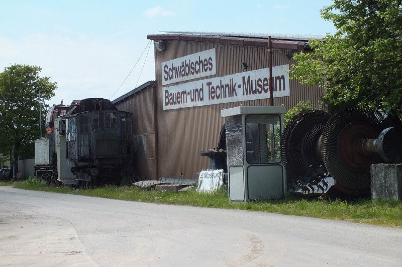
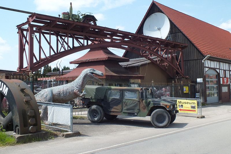
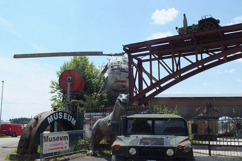
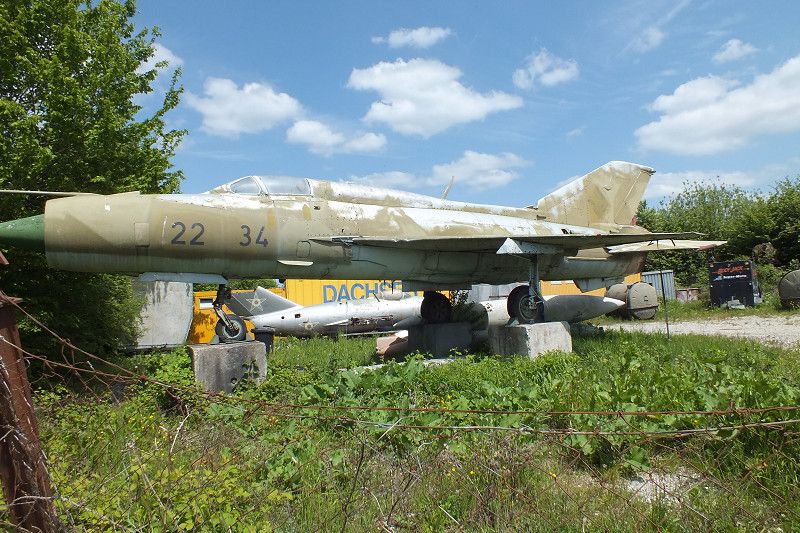
A visit to the "Swabian Farmers and Technology Museum", which is usually open on weekends, is a good idea here.
The mostly military exhibits are certainly not to everyone's taste, but their composition is at least curious.
The "Seifertshofener Traktor Pulling" in summer is also well known.
Further information: https://museum-kiemele.de
Seifertshofen, 73569, Eschach, Deutschland
48° 54' 33.2" N 9° 50' 16.2" E
48.9092320 9.8378439
• Head southwest on Im Oberweiler. Go for 17 m.
• Turn sharp right toward Marktstraße/L1080. Go for 29 m.
• Turn left onto Marktstraße (L1080). Go for 2.8 km.
• Arrive at Eschacher Straße (L1080). Your destination is on the right.
☍
2,8 km
( 2 min.)
Mittelbronn, Deutschland
Mittelbronn, 73577, Gschwend, Deutschland
48° 55' 17" N 9° 48' 20" E
48.9213866 9.8055499
• Head toward Hohlgasse on Eschacher Straße (L1080). Go for 1.8 km.
• Arrive at Höhenstraße (L1080). Your destination is on the right.
☍
1,8 km
( 1 min.)
Frickenhofen, Deutschland
Frickenhofen, 73577, Gschwend, Deutschland
48° 55' 50.2" N 9° 47' 48.9" E
48.9306153 9.7969031
• Head toward Nußgasse on Höhenstraße (L1080). Go for 1.6 km.
• Turn right onto Hohentannenstraße (K3330). Go for 1.4 km.
• Continue on K2662. Go for 3.3 km.
• Turn left onto Schönberger Straße (K2663). Go for 1.2 km.
• Arrive at Schönberger Straße (K2663). Your destination is on the left.
☍
7,5 km
( 7 min.)
Unterrot, Deutschland
Unterrot, 74405, Gaildorf, Deutschland
48° 58' 49.8" N 9° 46' 37.7" E
48.9805121 9.7771381
• Head northwest on Schönberger Straße (K2663).
• Turn right onto Hauptstraße (B298). Go for 346 m.
• Turn right onto B298 toward Schwäbisch Hall/Gaildorf/Crailsheim. Go for 2.1 km.
• Arrive at Marktplatz (B19).
☍
2,5 km
( 2 min.)
Gaildorf, Deutschland
Gaildorf, 74405, Deutschland
49° 0' 0.9" N 9° 46' 11.5" E
49.0002603 9.7698525
• Head west on Marktplatz (B19).
• Continue on Bahnhofstraße (B19) toward Heilbronn/A6/Nürnberg/Schwäbisch Hall. Go for 9.9 km.
• Turn right onto Unterdorfstraße. Go for 38 m.
• Arrive at Unterdorfstraße. Your destination is on the right.
☍
9,9 km
( 10 min.)
Gemeinde Rosengarten, Deutschland
Hauptstraße 39, 74538, Rosengarten, Deutschland
49° 4' 4.1" N 9° 43' 34.3" E
49.0678020 9.7261922
• Head toward Hauptstraße on Unterdorfstraße. Go for 38 m.
• Turn right onto Hauptstraße (B19). Go for 562 m.
• Take the 2nd exit from roundabout onto B19 toward Schwäbisch Hall. Go for 2.9 km.
• Turn left onto Dr.-Max-Bühler-Straße (K2669) toward Bibersfeld/Rosengarten-Raibach/Gewerbegebiet Stadtheide. Go for 212 m.
• Continue on Dr.-Max-Bühler-Straße (K2576). Go for 1.3 km.
• Take the 2nd exit from roundabout onto Dr.-Max-Bühler-Straße (K2576). Go for 3.7 km.
• Turn left onto Wackershofen. Go for 558 m.
• Turn left onto Dorfstraße. Go for 20 m.
• Continue on Moorwiesenweg. Go for 71 m.
• Arrive at Moorwiesenweg. Your destination is on the left.
☍
9,4 km
( 9 min.)
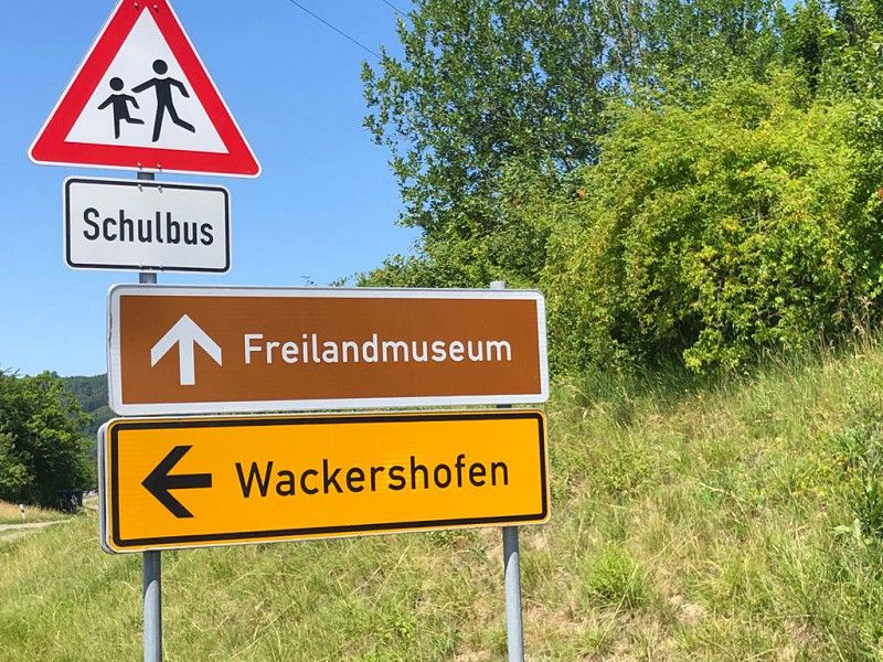
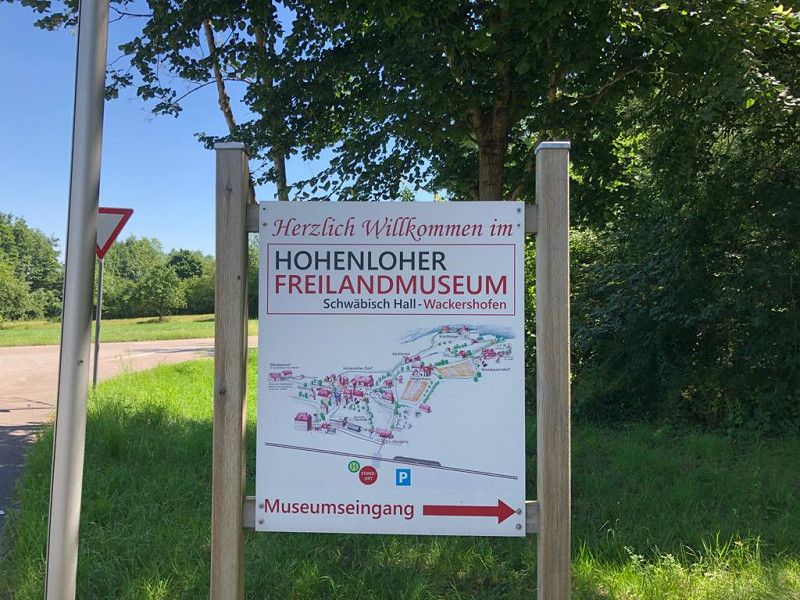
Wackershofen Freilandmuseum, Deutschland
Season from March 15th to November 15th.
The museum, founded in 1983, is one of the largest open-air museums in BW with over 70 historical buildings.
A program of guided tours and hands-on projects as well as a large number of events gives a lasting impression not only of rural life over the last 500 years.
Further information: https://www.wackershofen.de
Hohenlohestraße, 74523, Schwäbisch Hall, Deutschland
49° 8' 14.6" N 9° 41' 46.1" E
49.1373924 9.6961429
• Head west on Moorwiesenweg. Go for 13 m.
• Turn right. Go for 57 m.
• Turn right toward Moorwiesenweg. Go for 20 m.
• Turn left onto Moorwiesenweg. Go for 22 m.
• Continue on Dorfstraße. Go for 20 m.
• Turn right onto Wackershofen. Go for 558 m.
• Turn left onto K2576. Go for 4.0 km.
• Continue on B14. Go for 224 m.
• Arrive at B14.
☍
4,9 km
( 4 min.)
Übrigshausen, Baden-Württemberg, Germany
B 14, 74547, Germany
49° 10' 8.6" N 9° 42' 49.4" E
49.1690419 9.7137171
• Head east on B14. Go for 6 m.
• Turn left onto B19. Go for 9.7 km.
• Turn right onto K2374 toward Haag/Gaisbach/Gewerbegebiet Gaibach. Go for 522 m.
• Continue on Waldenburger Straße (K2374). Go for 292 m.
• Turn left onto Robert-Bosch-Straße. Go for 552 m.
• Continue on Dieselstraße. Go for 451 m.
• Turn left. Go for 134 m.
• Turn right. Go for 250 m.
• Arrive at your destination.
☍
11,9 km
( 13 min.)
Museum Würth 2 im Carmen Würth Forum, Am Forumsplatz 1, 74653 Künzelsau
The art museum shows major modern and contemporary works from the Würth Collection. It is free for visitors, has ample parking and the café invites you to linger.
Further information: https://kunst.wuerth.com/
Am Forumsplatz 1, 74653, Germany
49° 15' 43.1" N 9° 40' 23.2" E
49.2619795 9.6731186
• Head east. Go for 250 m.
• Turn left toward Dieselstraße. Go for 134 m.
• Turn right onto Dieselstraße. Go for 451 m.
• Continue on Robert-Bosch-Straße. Go for 543 m.
• Turn right onto Waldenburger Straße (K2374). Go for 292 m.
• Continue on K2374. Go for 464 m.
• Turn right onto B19. Go for 1.8 km.
• Take middle ramp toward Neufels/Kemmeten/Gaisbach Nord/Würth. Go for 112 m.
• Take the 4th exit from roundabout. Go for 440 m.
• Take the 2nd exit from roundabout onto L1051. Go for 4.1 km.
• Arrive at Gaisbacher Straße (L1051). Your destination is on the left.
☍
8,6 km
( 11 min.)
Wegpunkt
L 1051, 74632, Germany
49° 15' 1.7" N 9° 37' 26.6" E
49.2504762 9.6240541
• Head southeast on Gaisbacher Straße (L1051). Go for 1.2 km.
• Turn right onto L1046. Go for 3.5 km.
• Turn left onto Metzdorfer Straße (K2348) toward Metzdorf. Go for 42 m.
• Turn right onto Oberweiler. Go for 29 m.
• Arrive at Oberweiler. Your destination is on the left.
☍
4,8 km
( 4 min.)
Wohlmuthausen, Baden-Württemberg, Germany
Oberweiler 3, 74670, Germany
49° 15' 42" N 9° 34' 36" E
49.2616599 9.5766709
• Head toward Metzdorfer Straße on Oberweiler. Go for 29 m.
• Turn left onto Metzdorfer Straße (K2348). Go for 42 m.
• Turn left onto Hohenlohestraße (L1046). Go for 2.6 km.
• Take the 1st exit from roundabout onto L1048 toward Weißbach/Forchtenberg. Go for 2.4 km.
• Arrive at Öhringer Straße (L1048). Your destination is on the right.
☍
5,0 km
( 5 min.)
Forchtenberg
Forchtenberg with its beautiful old town center is the birthplace of Sophie Scholl. As an active member of the "White Rose" resistance organization against the Nazi regime, she was arrested in 1943, sentenced to death and executed shortly afterwards.
Öhringer Straße 42, 74670, Germany
49° 17' 14.6" N 9° 33' 42.9" E
49.2873765 9.5619218
• Head northwest on Öhringer Straße (L1048). Go for 583 m.
• Turn left onto Schöntaler Straße (K2320). Go for 775 m.
• Continue on K2320. Go for 2.7 km.
• Continue on K2321. Go for 171 m.
• Arrive at K2321.
☍
4,2 km
( 4 min.)
Tiroler See
On the right is a small lake with parking facilities
Tiroler-Seen-Weg, 74670, Germany
49° 19' 4.7" N 9° 33' 29.2" E
49.3179610 9.5581055
• Head northwest on K2321. Go for 1.8 km.
• Turn left onto K2321. Go for 1.2 km.
• Turn right toward Neusaß. Go for 318 m.
• Continue on Neusaß. Go for 33 m.
• Turn left onto Neusaß. Go for 39 m.
• Arrive at Neusaß. Your destination is on the right.
☍
3,4 km
( 3 min.)
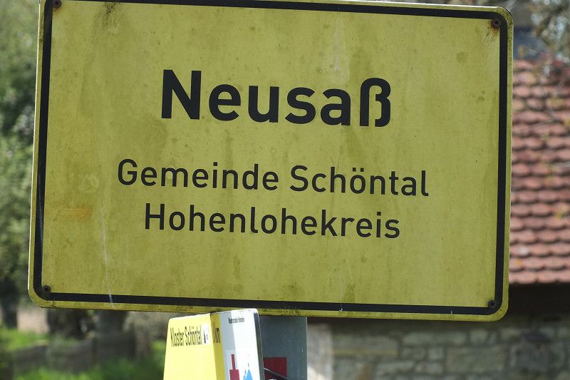
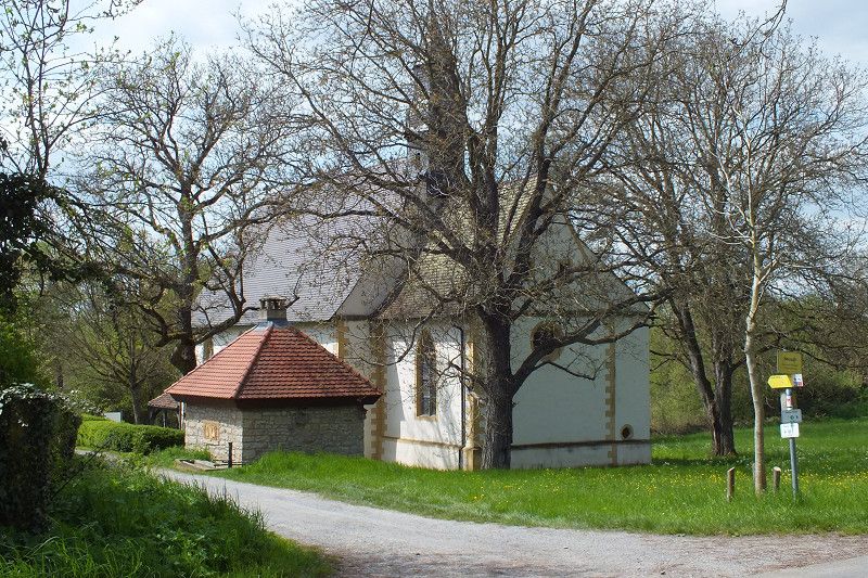
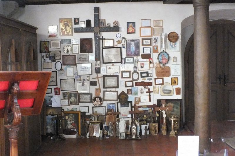
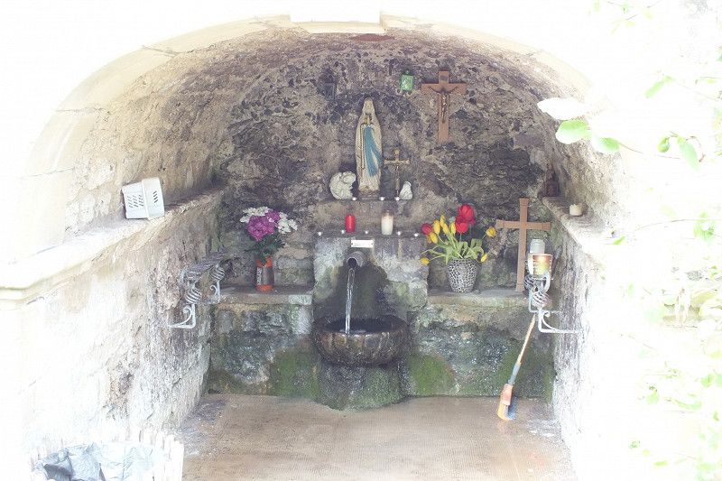
Wallfahrtskapelle Neusaß
The somewhat hidden chapel is the destination of a Marian pilgrimage that has been documented since 1395.
The countless votive tablets inside the chapel testify to the unshakable belief in Mary's help.
The one that springs from the chapel "Heiligenbrünnle" is said to have a healing effect.
From the parking facilities immediately after the junction, it is a 500 m long walk to the chapel.
74214, Schöntal, Germany
49° 19' 18" N 9° 31' 15.1" E
49.3216535 9.5208549
• Head east on Neusaß. Go for 39 m.
• Turn right onto Neusaß. Go for 351 m.
• Turn right onto K2321. Go for 478 m.
• Turn right onto K2322. Go for 598 m.
• Continue on Neusaßer Täle (K2322). Go for 164 m.
• Continue on K2322. Go for 697 m.
• Continue on Honigsteige (K2322). Go for 285 m.
• Turn right onto Kreuzbergweg. Go for 119 m.
• Turn sharp right. Go for 63 m.
• Arrive at your destination on the left.
☍
2,8 km
( 3 min.)
Kloster Schöntal
Parking lot Kloster Schöntal Großer Garten 8
Elongated parking lot opposite the monastery complex.
When you stand at the end, you hardly hear the traffic noise.
Incidentally, the "knight with the iron hand" (Götz von Berlichingen) found his last resting place in the cloister.
Honigsteige 5, 74214, Schöntal, Germany
49° 19' 46.2" N 9° 30' 27.9" E
49.3294924 9.5077575
• Head toward Kreuzbergweg. Go for 63 m.
• Turn sharp left onto Kreuzbergweg. Go for 119 m.
• Turn right onto Honigsteige (K2322). Go for 54 m.
• Turn left onto Großer Garten (L1025). Go for 1.9 km.
• Turn left onto Hauptstraße (K2321). Go for 417 m.
• Arrive at Hauptstraße (K2321). Your destination is on the right.
☍
2,5 km
( 3 min.)
Berlichingen, Deutschland
Berlichingen, 74214, Schöntal, Deutschland
49° 19' 37.2" N 9° 29' 13" E
49.3269972 9.4869475
• Head toward Marktplatz on Hauptstraße (K2321). Go for 417 m.
• Turn left onto Jagsthäuser Straße (L1025). Go for 3.5 km.
• Turn right onto Hauptstraße. Go for 23 m.
• Turn slightly left onto Sennenfelder Straße. Go for 30 m.
• Arrive at Sennenfelder Straße. Your destination is on the left.
☍
4,0 km
( 4 min.)
Jagsthausen, Baden-Württemberg, Germany
From June to August, the well-known castle festival takes place in the courtyard of the castle
In the castle museum you can admire the original of the iron hand of the knight Götz von Berlichingen.
Sennenfelder Straße 5, 74249, Germany
49° 18' 35.2" N 9° 28' 6.6" E
49.3097665 9.4685032
• Head toward Hauptstraße on Sennenfelder Straße. Go for 30 m.
• Turn slightly right onto Hauptstraße. Go for 23 m.
• Turn right onto Hauptstraße (L1025). Go for 327 m.
• Turn left onto Sindringer Straße (L1050). Go for 3.9 km.
• Turn left onto Untere Straße. Go for 74 m.
• Arrive at Untere Straße.
☍
4,4 km
( 5 min.)
Sindringen, Baden-Württemberg, Germany
Untere Straße 8, 74670, Germany
49° 16' 47.6" N 9° 28' 38.6" E
49.2799020 9.4774000
• Head toward Gaisberg on Untere Straße. Go for 74 m.
• Turn left onto L1050. Go for 224 m.
• Turn right onto L1045. Go for 5.5 km.
• Turn right onto Seehäldenweg. Go for 134 m.
• Arrive at Seehäldenweg. Your destination is on the right.
☍
6,0 km
( 4 min.)
Ohrnberg, Baden-Württemberg, Germany
If you feel like it, you can do a bike tour from Ohrnberg on a beautiful bike path along the Ohrn (unfortunately not suitable as a "circular path"), whereby you have to turn back on the way.
Seehäldenweg 7, 74613, Germany
49° 15' 5" N 9° 27' 26.1" E
49.2513883 9.4572423
• Head toward Möglinger Straße on Seehäldenweg. Go for 134 m.
• Turn left onto Möglinger Straße (L1045). Go for 124 m.
• Turn right onto Ohrntalstraße (K2384). Go for 6.3 km.
• Turn left onto Neuenstadter Straße (L1088). Go for 232 m.
• Turn left onto Hermann-Kollmar-Straße (K2331). Go for 108 m.
• Turn right onto Hermann-Kollmar-Straße. Go for 24 m.
• Arrive at Hermann-Kollmar-Straße. Your destination is on the right.
☍
6,9 km
( 7 min.)
Unterohrn, Baden-Württemberg, Germany
Hermann-Kollmar-Straße 87, 74613, Germany
49° 12' 40.2" N 9° 28' 33.3" E
49.2111635 9.4759071
• Head northwest on Hermann-Kollmar-Straße. Go for 24 m.
• Turn left onto Hermann-Kollmar-Straße (K2331). Go for 108 m.
• Turn left onto Neuenstadter Straße (L1088). Go for 528 m.
• Take the 1st exit from Ohrntal-Ring roundabout onto Westallee. Go for 1.1 km.
• Pass 2 roundabouts and continue on Westallee. Go for 910 m.
• Arrive at Westallee. Your destination is on the right.
☍
2,7 km
( 4 min.)
HEICamp Öhringen
If you want to do the tour in two (or more) days, the Öhringer parking space is the ideal place to stay.
Otherwise just follow the further route.
Verrenberger Weg 33, 74613, Öhringen, Germany
49° 11' 33.4" N 9° 28' 48.3" E
49.1926222 9.4800957
• Head toward Verrenberger Ring on Westallee. Go for 38 m.
• Take the 2nd exit from Verrenberger Ring roundabout onto Westallee. Go for 1.1 km.
• Take the 3rd exit from Treffener Ring roundabout onto Windischenbacher Straße (L1035). Go for 296 m.
• Take the 1st exit from Schlüsselring roundabout onto Pfedelbacher Straße (L1050). Go for 1.7 km.
• Take the 2nd exit from Hohenloher Platz roundabout onto Hauptstraße (L1050). Go for 71 m.
• Turn left onto Kelterstraße. Go for 92 m.
• Arrive at Kelterstraße. Your destination is on the right.
☍
3,3 km
( 3 min.)
Day
Pfedelbach, Baden-Württemberg, Germany
Palace complex and wine museum
Kelterstraße 7, 74629, Germany
49° 10' 41.6" N 9° 30' 25.7" E
49.1782239 9.5071486
• Head toward Kirchgasse on Kelterstraße. Go for 92 m.
• Turn left onto Hauptstraße (L1050). Go for 249 m.
• Turn right onto Windischenbacher Straße (K2347) toward Adolzfurt/Windischenbach. Go for 880 m.
• Continue on Pfedelbacher Straße (K2347). Go for 787 m.
• Turn left onto Adolzfurter Straße (L1035). Go for 2.9 km.
• Arrive at L1035. Your destination is on the right.
☍
4,9 km
( 5 min.)
Windischenbach, Baden-Württemberg, Germany
Be sure to visit the "Hohenlohe Fürstenfass winery" beforehand (Alter Berg 1, 74626 Bretzfeld).
Further information: www.fuerstenfass.de
L 1035, 74626, Germany
49° 9' 42.7" N 9° 27' 23.5" E
49.1618551 9.4565296
• Head toward Unterheimbacher Straße on L1035. Go for 37 m.
• Turn left onto L1090 toward Wüstenrot/Unterheimbach/Brettach/Geddelsbach. Go for 428 m.
• Turn left onto K2345 toward Brettach. Go for 2.6 km.
• Continue on Untere Brettachtalstraße (K2345). Go for 767 m.
• Continue on Obere Brettachtalstraße (K2345). Go for 11 m.
• Arrive at Obere Brettachtalstraße (K2345). Your destination is on the right.
☍
3,9 km
( 3 min.)
Geddelsbach, Deutschland
From Geddelsbach you follow a road that is narrow in places along the Brettach to Mainhardt.
Geddelsbach, 74629, Bretzfeld, Deutschland
49° 8' 34.7" N 9° 29' 55.1" E
49.1429630 9.4986498
• Head southeast on Obere Brettachtalstraße (K2345). Go for 403 m.
• Continue on K2345. Go for 2.4 km.
• Continue on Steinscharren (K2345). Go for 139 m.
• Continue on Mainhardter Straße (K2345). Go for 1.1 km.
• Continue on K2345. Go for 1.7 km.
• Continue on Laukenmühle (K2582). Go for 182 m.
• Continue on K2582. Go for 2.1 km.
• Turn right onto L1050. Go for 1.7 km.
• Arrive at Marktplatz (L1050). Your destination is on the left.
☍
9,7 km
( 9 min.)
Mainhardt, Deutschland
Mainhardt, 74535, Deutschland
49° 4' 53" N 9° 33' 28.5" E
49.0813807 9.5579299
• Head southwest on Marktplatz (L1050). Go for 672 m.
• Turn right onto Heilbronner Straße (B14). Go for 4.2 km.
• Arrive at Mainhardter Straße (B14). Your destination is on the left.
☍
4,9 km
( 4 min.)
Großerlach, Deutschland
Those who can spare a little time shouldn't miss the testimonies of Roman culture.
Further information: www.limesstrasse.de/deutsche-limes-strasse/limes-strasse/members places/grosserlach
Großerlach, 71577, Deutschland
49° 3' 15.5" N 9° 30' 59.1" E
49.0543040 9.5164159
• Head toward Gartenstraße on Mainhardter Straße (B14). Go for 6.6 km.
• Turn left onto Haller Straße (L1066) toward Geildorf/Murrhardt/Sulzbach a.d.M./Ortsmitte/Zentrum/Gewerbegebiet Süd/Ost. Go for 283 m.
• Continue on Haller Straße (K1815). Go for 80 m.
• Turn left onto Milchstraße (K1815). Go for 118 m.
• Turn right onto Kirchhofweg. Go for 20 m.
• Arrive at Kirchhofweg.
☍
7,1 km
( 6 min.)
Sulzbach an der Murr, Baden-Württemberg, Germany
Kirchhofweg 16, 71560, Germany
49° 0' 11.6" N 9° 30' 13.5" E
49.0032177 9.5037612
• Head toward Brückengasse on Kirchhofweg. Go for 126 m.
• Turn right onto Haller Straße. Go for 52 m.
• Turn right onto Haller Straße. Go for 194 m.
• Turn right onto L1066. Go for 4.1 km.
• Take the 2nd exit from roundabout onto L1066. Go for 2.3 km.
• Turn right onto Hauptstraße. Go for 145 m.
• Arrive at Hauptstraße. Your destination is on the right.
☍
6,9 km
( 8 min.)
Murrhardt, Deutschland
Murrhardt, 71540, Deutschland
48° 58' 47.2" N 9° 34' 46.1" E
48.9797657 9.5794661
• Head toward Kirchgasse on Hauptstraße. Go for 145 m.
• Turn right onto Theodor-Heuss-Straße (L1066). Go for 4.2 km.
• Turn right onto L1149. Go for 5.2 km.
• Take the 2nd exit from roundabout onto Gschwender Straße (L1150). Go for 4.2 km.
• Turn right onto Wildgarten (B298). Go for 1.6 km.
• Take the 2nd exit from roundabout onto Gaildorfer Straße (B298). Go for 397 m.
• Turn right onto Welzheimer Straße (L1080) toward Welzheim. Go for 56 m.
• Arrive at Welzheimer Straße (L1080). Your destination is on the right.
☍
15,7 km
( 16 min.)
Gschwend, Baden-Württemberg, Germany
Welzheimer Straße 2, 74417, Germany
48° 56' 3.2" N 9° 44' 33.4" E
48.9342268 9.7426237
• Head toward Frickenhofer Straße on Welzheimer Straße (L1080). Go for 56 m.
• Turn right onto Gmünder Straße (B298). Go for 8.3 km.
• Turn right onto Kirchplatz. Go for 49 m.
• Arrive at Kirchplatz. Your destination is on the left.
☍
8,5 km
( 8 min.)
Spraitbach, Deutschland
Spraitbach, 73565, Deutschland
48° 52' 49" N 9° 45' 41.7" E
48.8802914 9.7615925
• Head toward Mutlanger Straße on Kirchplatz. Go for 49 m.
• Turn right onto Mutlanger Straße (B298). Go for 10.2 km.
• Turn left onto Graf-von-Soden-Straße (B298) toward Stuttgart/B29/Aalen/Herlikofen. Go for 676 m.
• Turn left onto Herlikofer Straße (L1075). Go for 126 m.
• Turn left onto Schießtalstraße. Go for 318 m.
• Continue on Richard-Bullinger-Straße. Go for 37 m.
• Turn right onto Schießtalstraße. Go for 69 m.
• Arrive at Schießtalstraße. Your destination is on the left.
☍
11,5 km
( 11 min.)
Wohnmobilstellplatz am Bud Spencer Bad
Schießtalstraße, 73527, Schwäbisch-Gmünd, Germany
48° 48' 21.8" N 9° 48' 52.2" E
48.8060442 9.8144923