The heart of this route (it will be 70 years old this year) and most of the texts are taken from the "Romantic Road" route map of the Tourist Association (www.romantischestrasse.de). I only adapted the start and end point to our needs. I also tried to subdivide the route into (sensible) daily stages and also added overnight accommodation. More places can be found on the website of the study group (https://www.romantischestrasse.de/camping-wohnmobile/wohnmobilstellplaetze/).
Day
Schwäbisch Gmünd - Stellplatz am Freibad
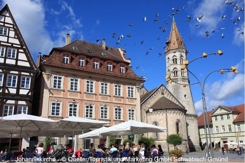
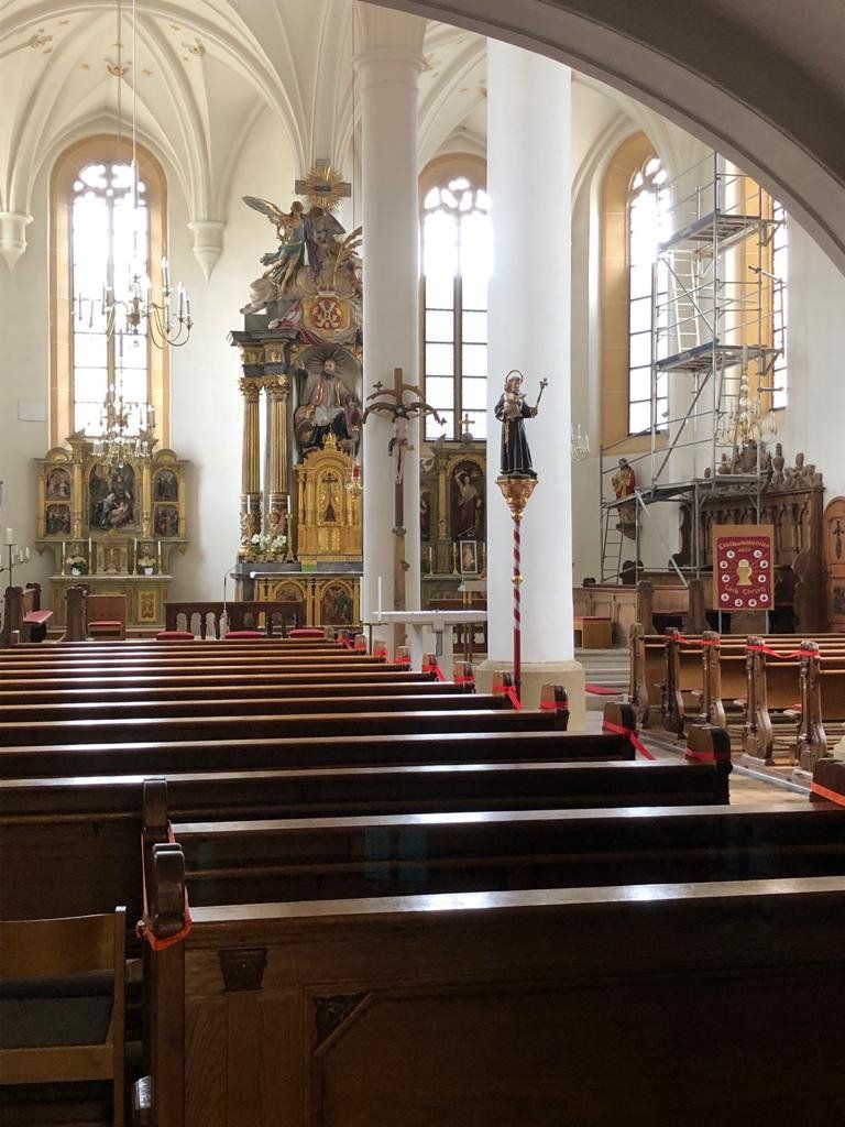
Picturesquely located at the foot of the Swabian Alb and the Dreikaiserberge, Schwäbisch Gmünd is a place with a very unique atmosphere. From the Romans and the Middle Ages to the knights and castles of the Staufer to the lush, lively baroque, the classic to a modern, creative and vibrant city. Buildings from eight centuries characterize the historic city center. The market square and the Münsterplatz are among the most beautiful squares in southern Germany. You should not miss a visit to the Heiligkreuzmünster - one of the most beautiful and largest Gothic hall churches - and the Staufer basilica, the "Johanniskirche" with its sloping, accessible tower and the artistic design of the interior. In addition, especially with the urban redevelopment for the State Garden Show 2014, not only the cityscape was further developed in a forward-looking way.
Attention: The parking space situation in Schwäbisch Gmünd has changed.
Information can be found at: https://www.gmuender-baeder.de/wohnmobilhafen.html
Schießtalstraße 13, 73525, Schwäbisch Gmünd, Deutschland
48° 48' 17" N 9° 48' 49" E
48.8047222 9.8136111
• Head west. Go for 33 m.
• Turn right toward Richard-Bullinger-Straße. Go for 160 m.
• Turn right onto Richard-Bullinger-Straße. Go for 37 m.
• Continue on Schießtalstraße. Go for 318 m.
• Turn right onto Herlikofer Straße (L1075). Go for 126 m.
• Turn right onto Graf-von-Soden-Straße (B298). Go for 676 m.
• Turn right onto Pfitzerstraße (B298). Go for 4.4 km.
• Turn left onto Schafhaus (L1155) toward Alfdorf/Welzheim. Go for 13.7 km.
• Turn right onto Stuttgarter Straße (L1150). Go for 857 m.
• Turn right. Go for 42 m.
• Turn right toward Schorndorfer Straße. Go for 127 m.
• Continue on Schorndorfer Straße. Go for 1.0 km.
• Turn left onto Kurze Straße. Go for 184 m.
• Turn right onto Bahnhofstraße. Go for 137 m.
• Turn right onto Postweg. Go for 54 m.
• Arrive at Postweg. Your destination is on the right.
☍
21,9 km
( 24 min.)
Welzheim, Deutschland
Welzheim was one of the most important troop locations on the Upper German Limes in the 2nd and 3rd centuries. The proof of this is the unusual number of three castles, the East Castle, the West Castle and the Rötelsee Small Castle. Between the castles, civilians lived a border settlement, the "Vicus".
We recommend the "Museum Welzheim" (http://www.museumwelzheim.de/). The "Virtual Limes Worlds" in 3D, the animation model of a military camp and an electronic interactive model about the methods of modern archeology, which provide insights into the Roman era in Welzheim, complete the exhibition on the ground floor.
48° 52' 28" N 9° 37' 54.6" E
48.8744378 9.6318238
• Head toward Bahnhofstraße on Postweg. Go for 54 m.
• Turn right onto Bahnhofstraße. Go for 77 m.
• Turn right onto Brunnenstraße. Go for 217 m.
• Turn left onto Schorndorfer Straße. Go for 109 m.
• Continue on Kirchplatz. Go for 87 m.
• Continue on Wilhelmstraße. Go for 182 m.
• Turn right onto Gottlob-Bauknecht-Platz. Go for 865 m.
• Take the 2nd exit from roundabout onto Rübäcker (L1150). Go for 4.9 km.
• Take the 2nd exit from roundabout onto L1120. Go for 6.6 km.
• Turn left onto L1149. Go for 752 m.
• Turn left onto L1066. Go for 3.9 km.
• Continue on Theodor-Heuss-Straße (L1066). Go for 2.6 km.
• Take the 2nd exit from roundabout onto L1066. Go for 4.1 km.
• Turn left onto Haller Straße (K1815). Go for 80 m.
• Continue on Haller Straße. Go for 114 m.
• Turn left onto Haller Straße. Go for 31 m.
• Turn left onto Brückengasse. Go for 21 m.
• Arrive at Brückengasse. Your destination is on the left.
☍
24,7 km
( 26 min.)
Sulzbach an der Murr, Deutschland
49° 0' 12.1" N 9° 30' 9.1" E
49.0033520 9.5025263
• Head east on Brückengasse.
• Turn right onto Brückengasse. Go for 25 m.
• Turn right onto Kirchhofweg. Go for 36 m.
• Turn right onto Haller Straße. Go for 52 m.
• Turn right onto Haller Straße. Go for 194 m.
• Continue on Haller Straße (L1066). Go for 11.1 km.
• Turn left onto Hauptstraße (L1050) toward Öhringen/Gailsbach. Go for 2.4 km.
• Turn left onto K2582. Go for 2.1 km.
• Continue on Laukenmühle (K2582). Go for 182 m.
• Continue on K2345. Go for 1.7 km.
• Continue on Mainhardter Straße (K2345). Go for 1.1 km.
• Continue on Steinscharren (K2345). Go for 139 m.
• Continue on K2345. Go for 2.4 km.
• Continue on Obere Brettachtalstraße (K2345). Go for 414 m.
• Continue on Untere Brettachtalstraße (K2345). Go for 767 m.
• Continue on K2345. Go for 2.6 km.
• Turn right onto L1090. Go for 428 m.
• Continue on Unterheimbacher Straße (L1035). Go for 1.0 km.
• Continue on Am Zollstock (L1090). Go for 1.6 km.
• Turn left onto Einsteinstraße (L1089). Go for 496 m.
• Turn left. Go for 20 m.
• Turn left. Go for 76 m.
• Arrive at your destination on the right.
☍
28,8 km
( 31 min.)
Bretzfeld, Deutschland
74626 Bretzfeld, Deutschland
49° 10' 36.6" N 9° 26' 10.8" E
49.1768236 9.4363239
• Head southwest. Go for 76 m.
• Turn right toward Einsteinstraße/L1089. Go for 20 m.
• Turn right onto Einsteinstraße (L1089). Go for 496 m.
• Turn left onto Bitzfelder Straße (L1090). Go for 1.4 km.
• Turn right onto Heilbronner Straße (L1036). Go for 76 m.
• Turn left onto Weißlensburger Straße (L1090). Go for 94 m.
• Turn right onto Schwöllbronner Straße (L1090) toward Schwöllbronn. Go for 367 m.
• Continue on Schwöllbronner Weg (L1090). Go for 613 m.
• Continue on L1090. Go for 1.1 km.
• Continue on Bitzfelder Straße (L1090). Go for 281 m.
• Continue on Zuckmantelstraße (L1090). Go for 346 m.
• Continue on Erlenbacher Weg (L1090). Go for 459 m.
• Turn left onto Neuenstadter Straße (L1088). Go for 930 m.
• Turn right onto K2333 toward Möglingen/Baumerlenbach. Go for 1.6 km.
• Continue on Gartenbühlstraße (K2333). Go for 681 m.
• Continue on Erlengrundstraße (K2333). Go for 556 m.
• Continue on Erlenbachstraße (K2333). Go for 511 m.
• Continue on L1045. Go for 2.3 km.
• Turn right onto Lampoldshauser Straße (K2130). Go for 503 m.
• Take the 2nd exit from roundabout onto Lampoldshauser Straße (K2130). Go for 3.9 km.
• Keep right onto K2130. Go for 2.5 km.
• Turn left onto L1047. Go for 322 m.
• Take the 1st exit from roundabout onto K2132. Go for 3.1 km.
• Turn right onto Züttlinger Straße (L1095). Go for 352 m.
• Turn left onto Haag (L1095). Go for 308 m.
• Turn left onto Bahnhofstraße (L527). Go for 183 m.
• Turn left onto K2024. Go for 119 m.
• Continue on Eisenbahnstraße (K2024). Go for 47 m.
• Turn right onto Reichertshäuser Straße (K2024). Go for 186 m.
• Turn left onto Reichertshäuser Straße. Go for 20 m.
• Turn right onto Südstraße. Go for 52 m.
• Turn right onto Uhlandstraße. Go for 64 m.
• Arrive at Uhlandstraße. Your destination is on the right.
☍
23,5 km
( 29 min.)
Möckmühl, Deutschland
A tour through the old town of Möckmühl is interesting, its medieval cityscape was largely spared from war destruction. In the town hall you can get a flyer on request
74219 Möckmühl, Deutschland
49° 19' 20.7" N 9° 21' 14.6" E
49.3224123 9.3540694
• Head toward Schwärzweg on Uhlandstraße. Go for 92 m.
• Turn right onto Schwärzweg. Go for 80 m.
• Turn right onto Reichertshäuser Straße (K2024). Go for 285 m.
• Turn left onto Eisenbahnstraße (K2024). Go for 47 m.
• Continue on K2024. Go for 119 m.
• Turn right onto Bittelbronner Straße (L527). Go for 183 m.
• Turn left onto Haag (L1095) toward Adelsheim/Roigheim. Go for 5.4 km.
• Continue on Adelsheimer Straße (L1095) toward Adelsheim. Go for 7.0 km.
• Continue on Marktstraße (B292). Go for 327 m.
• Turn left onto Lachenstraße (L519) toward Buchen/Seckach/Gewerbegebiet Obere Lache. Go for 7.2 km.
• Take the 1st exit from roundabout onto Bahnhofstraße (L519). Go for 8.0 km.
• Turn left and take ramp. Go for 232 m.
• Turn left onto B27. Go for 9.7 km.
• Turn right and take ramp toward A81/Heilbronn/Heidelberg/Mosbach/Buchen. Go for 402 m.
• Take the 2nd exit from roundabout. Go for 132 m.
• Turn right onto Buchener Straße. Go for 397 m.
• Continue on Adolf-Kolping-Straße. Go for 40 m.
• Take the 3rd exit from roundabout onto Dr.-Heinrich-Köhler-Straße. Go for 328 m.
• Continue on Ringstraße. Go for 148 m.
• Turn right onto Schachleiterstraße. Go for 283 m.
• Arrive at Schachleiterstraße. Your destination is on the right.
☍
40,4 km
( 36 min.)
Walldürn, Deutschland
Those who are interested in culture should visit the basilica. The Goldschmitt Technology Center in Walldürn is probably almost as interesting for motorhome drivers.
74731 Walldürn, Deutschland
49° 34' 51.9" N 9° 21' 43.8" E
49.5810849 9.3621600
• Head toward Friedrich-Ebert-Straße on Schachleiterstraße. Go for 75 m.
• Turn left onto Ostpreußenstraße. Go for 296 m.
• Turn right onto Ringstraße. Go for 131 m.
• Continue on Theodor-Heuss-Ring. Go for 945 m.
• Turn right onto Miltenberger Straße. Go for 593 m.
• Turn left onto Dr.-Konrad-Adenauer-Straße. Go for 543 m.
• Turn left onto Wettersdorfer Straße (K3910). Go for 149 m.
• Continue on K3910. Go for 4.3 km.
• Continue on Odenwaldstraße (K3910). Go for 135 m.
• Turn right onto Odenwaldstraße (K3910). Go for 591 m.
• Continue on K3910. Go for 994 m.
• Continue on Vollmersdorfer Straße (K3910). Go for 142 m.
• Continue on Wiesenstraße (K3910). Go for 1.4 km.
• Continue on K3910. Go for 56 m.
• Turn left onto K3911. Go for 710 m.
• Continue on MIL24. Go for 4.3 km.
• Turn left onto L521. Go for 883 m.
• Continue on Gaimühle (St521). Go for 285 m.
• Turn right onto Richelbacher Straße (MIL15). Go for 153 m.
• Continue on MIL15. Go for 1.5 km.
• Continue on Hauptstraße (MIL15). Go for 790 m.
• Continue on MIL15. Go for 1.3 km.
• Continue on Erftalstraße (MIL15). Go for 142 m.
• Turn left onto Römerstraße (St537). Go for 314 m.
• Turn right onto Frankenstraße (St507). Go for 1.5 km.
• Continue on L507. Go for 4.6 km.
• Turn left onto Nassiger Straße (L508). Go for 5.9 km.
• Turn right onto Bismarckstraße. Go for 196 m.
• Continue on Hans-Bardon-Straße. Go for 147 m.
• Turn right onto Wilhelm-Langguth-Straße. Go for 40 m.
• Arrive at Wilhelm-Langguth-Straße. Your destination is on the right.
☍
33,0 km
( 33 min.)
Wertheim, Deutschland
The old town of Wertheim is always worth a visit :-)) A visit to the Wertheim Village is also tempting.
97877 Wertheim, Deutschland
49° 45' 31" N 9° 30' 46.3" E
49.7586035 9.5128511
• Head west on Wilhelm-Langguth-Straße. Go for 7 m.
• Turn left onto Schützenstraße. Go for 68 m.
• Turn right onto Ferdinand-Hotz-Straße. Go for 249 m.
• Turn right onto Alte Vockenroter Steige. Go for 201 m.
• Turn right onto Uihleinstraße (L508). Go for 375 m.
• Turn right onto Bahnhofstraße. Go for 224 m.
• Turn left toward Rechte Tauberstraße/L506. Go for 81 m.
• Turn left onto Rechte Tauberstraße (L506). Go for 254 m.
• Turn right onto Packhofstraße (L2310). Go for 9.9 km.
• Take ramp onto A3 toward Würzburg. Go for 14.3 km.
• Take exit 67 toward Würzburg. Go for 267 m.
• Turn left onto B468 toward Würzburg. Go for 1.2 km.
• Turn right onto St2312. Go for 9.3 km.
• Keep left onto Höchberger Straße (B8/B27) toward Würzburg-Nord/Nürnberg/Schweinfurt/B19/Fulda. Go for 2.3 km.
• Keep right onto Neunerplatz (B8/B27) toward B13/Ansbach/B19/Schwäbisch Hall/Centrum. Go for 375 m.
• Turn right onto Dreikronenstraße. Go for 181 m.
• Turn left onto Dreikronenstraße. Go for 76 m.
• Turn left. Go for 67 m.
• Arrive at your destination on the left.
☍
39,4 km
( 32 min.)
Würzburg - Stellplatz Friedensbrücke
The parking space is relatively busy. This is where the actual route "Romantic Road" begins. A visit to Würzburg is also highly recommended. The university and congress city on the Main lies in the middle of the Franconian wine country. It is dominated by the Marienberg Fortress. In addition to the Prince-Bishops' Residence (UNESCO World Heritage Site), the baroque splendor building by Balthasar Neumann, the cathedral, Neumünster, Marienkapelle, Marktplatz and the Old Main Bridge are worth seeing in the old town.
Dreikronenstraße 2, 97070, Würzburg, Deutschland
49° 47' 52" N 9° 55' 23" E
49.7977778 9.9230556
• Head northwest.
• Turn left. Go for 47 m.
• Turn left toward Dreikronenstraße. Go for 72 m.
• Turn right onto Dreikronenstraße. Go for 40 m.
• Turn right onto Dreikronenstraße. Go for 181 m.
• Turn right onto Luitpoldstraße (B8/B27). Go for 379 m.
• Continue on Röntgenring (B8). Go for 1.2 km.
• Take the 4th exit from Berliner Platz roundabout onto Martin-Luther-Straße. Go for 429 m.
• Turn left onto Annastraße. Go for 212 m.
• Turn slightly left onto Siligmüllerstraße. Go for 247 m.
• Continue on Siligmüllerbrücke. Go for 65 m.
• Continue on Salvatorstraße. Go for 405 m.
• Arrive at Salvatorstraße. Your destination is on the left.
☍
3,3 km
( 7 min.)
Day
Besichtigung in Würzburg
It would be a shame to drive past the city so carelessly. A leisurely stroll through the city with a bit of culture (at least the Residenz) is actually part of it.
Würzburg, Deutschland
49° 47' 28.7" N 9° 57' 12.1" E
49.7913044 9.9533548
• Head south on Salvatorstraße.
• Turn right onto Rottendorfer Straße (WÜs24). Go for 337 m.
• Turn left onto Stadtring Süd (B19). Go for 4.8 km.
• Take ramp onto A3 toward Frankfurt/Stuttgart. Go for 6.1 km.
• Take exit 69 toward Stuttgart/Heilbronn/Tauberbischofsheim onto A81. Go for 22.3 km.
• Take exit 3 toward Walldürn/Tauberbischofsheim. Go for 351 m.
• Turn left toward Walldürn/Tauberbischofsheim. Go for 50 m.
• Continue on B27. Go for 1.6 km.
• Continue on L506. Go for 1.5 km.
• Turn left. Go for 499 m.
• Arrive at your destination on the right.
☍
37,6 km
( 24 min.)
Day
Tauberbischofsheim, Deutschland
The district town of the Main-Tauber district is one of the oldest towns in the "Lovely Tauber Valley". The Kurmainz Castle is grouped around the landmark of the half-timbered town, the tower tower. The neo-Gothic town hall with carillon is the most striking building next to numerous houses worth seeing Market place.
49° 37' 45.8" N 9° 39' 33.5" E
49.6293817 9.6592956
• Head southwest.
• Take the 3rd exit from roundabout. Go for 603 m.
• Turn right onto Wertheimer Straße (L506). Go for 1.5 km.
• Continue on B27. Go for 1.6 km.
• Continue on B290 toward Bad Mergentheim. Go for 4.7 km.
• Turn right onto Am Wörth (L511) toward Lauda/Weinort/Gewerbegebiet Lauda-Ost. Go for 438 m.
• Take the 1st exit from roundabout onto Am Wörth (L511). Go for 212 m.
• Turn right onto Bahnhofstraße (L511). Go for 673 m.
• Continue on Becksteiner Straße (K2832). Go for 250 m.
• Turn right onto Hohenloher Straße. Go for 172 m.
• Turn left onto Lienhart-Beys-Straße. Go for 53 m.
• Arrive at Lienhart-Beys-Straße. Your destination is on the left.
☍
10,2 km
( 11 min.)
Lauda-Königshofen, Deutschland
Wine town with magnificent churches from the heyday of the Franconian Baroque, historical bridges, stately half-timbered houses and shrines from six centuries. Local history museum (focus on viticulture), guided tours through nature, culture and wine trails, leisure facilities such as a heated outdoor pool, indoor pool with sauna and solarium. Directly on the "Liebliches Taubertal" cycle route, the start and end point of the Main-Tauber-Franconian cycle aft. Wonderful short and circular hiking trails through an idyllic landscape.
97922 Lauda-Königshofen, Deutschland
49° 33' 54.4" N 9° 42' 1.4" E
49.5651125 9.7003795
• Head south on Lienhart-Beys-Straße. Go for 75 m.
• Turn left onto Kaiser-Ludwig-Straße. Go for 198 m.
• Turn right onto Becksteiner Straße (K2832). Go for 805 m.
• Take the 2nd exit from roundabout onto K2832. Go for 2.2 km.
• Turn left onto B292. Go for 772 m.
• Turn right onto Hauptstraße (B290) toward Bad Mergentheim. Go for 5.8 km.
• Take the 2nd exit from roundabout onto B290 toward Gewerbegebiet Im Abelt/Gewerbegebiet Ried/Heilbronn/A81/Crailsheim. Go for 793 m.
• Turn left onto Schillerstraße toward Altstadt. Go for 392 m.
• Take the 2nd exit from roundabout onto Mittlerer Graben. Go for 221 m.
• Turn right onto Propsteistraße. Go for 45 m.
• Arrive at Propsteistraße. Your destination is on the left.
☍
11,4 km
( 13 min.)
Bad Mergentheim, Deutschland
The former residence city of the high and German masters of the Teutonic Order has enjoyed an international reputation as a health city for years. Bad Mergentheim is known for the Teutonic Order Palace with the castle church and museum, the Stuppacher Madonna (worthwhile detour), the Solymar bathing and wellness park or the wildlife park. Proud half-timbered houses and baroque palaces flock to the market square with the splendid Renaissance town hall and the cathedral St. Johannes with the Münsterschatz.
97980 Bad Mergentheim, Deutschland
49° 29' 18.7" N 9° 46' 13.5" E
49.4885370 9.7704158
• Head toward Mittlerer Graben on Propsteistraße. Go for 45 m.
• Turn right onto Mittlerer Graben. Go for 184 m.
• Continue on Oberer Graben. Go for 127 m.
• Turn right onto Oberer Graben. Go for 40 m.
• Turn left onto Würzburger Straße. Go for 149 m.
• Continue on Igersheimer Straße. Go for 1.8 km.
• Turn left onto B19 toward Würzburg/A19/Rothenburg ob der Tauber/Igersheim. Go for 1.3 km.
• Continue on L2251 toward Rothenburg. Go for 1.1 km.
• Pass 3 roundabouts and continue on August-Laukhuff-Straße (L1001). Go for 7.9 km.
• Take the 1st exit from roundabout onto Gartenstraße (K2858). Go for 143 m.
• Continue on Friedrichstraße (K2858). Go for 60 m.
• Turn left onto Kanalstraße. Go for 156 m.
• Arrive at Kanalstraße. Your destination is on the left.
☍
13,0 km
( 13 min.)
Weikersheim, Deutschland
Weikersheim delights with the magnificent Renaissance castle with its spacious and beautifully laid out palace park in the style of Versailles. The completely preserved interior from the 16th to 18th centuries is unique. The market square with its stately offices, the grain building with the Tauberland village museum, the Gothic town church and the Rococo fountain is of a unique unity. Weikersheim also has a well-developed network of hiking and biking trails.
97990 Weikersheim, Deutschland
49° 28' 50.3" N 9° 54' 12.4" E
49.4806358 9.9034504
• Head northwest on Kanalstraße. Go for 156 m.
• Turn right onto Friedrichstraße (K2858). Go for 60 m.
• Continue on Gartenstraße (K2858). Go for 122 m.
• Take the 3rd exit from roundabout onto Bismarckstraße (L1001). Go for 547 m.
• Take the 1st exit from roundabout onto L1001 toward Rothenburg o.d. Tauber/Schäftersheim/Würzburg/Karlsberg/Sternwarte/Gewerbegebiet Nord. Go for 1.8 km.
• Continue on An der Romantischen Straße (L2251). Go for 852 m.
• Continue on St2269. Go for 4.6 km.
• Turn right onto Würzburger Straße (St2268). Go for 100 m.
• Turn left onto Gartenstraße. Go for 31 m.
• Turn slightly left onto Am Laubberg. Go for 137 m.
• Turn sharp right onto Sankt-Bruno-Straße. Go for 184 m.
• Arrive at Sankt-Bruno-Straße. Your destination is on the right.
☍
8,6 km
( 8 min.)
Röttingen, Deutschland
Embedded in gentle hills and vineyards, the town of Röttingen is located directly on the Romantic Road in the lovely Tauber Valley. Röttingen, with its medieval town center, beautiful half-timbered houses and the baroque town hall, is framed by a historic city fortification with seven well-preserved defense towers. Particularly impressive is the approx. Two kilometer long sundial path, equipped with 25 unique timepieces.
97285 Röttingen, Deutschland
49° 30' 44" N 9° 58' 18.5" E
49.5122355 9.9718105
• Head toward Obere Siedlerstraße on Sankt-Bruno-Straße. Go for 68 m.
• Continue on Untere Siedlerstraße. Go for 146 m.
• Turn sharp right onto Poststraße. Go for 312 m.
• Turn sharp left onto Rothenburger Straße (St2268). Go for 7.0 km.
• Continue on L2251. Go for 2.0 km.
• Turn right onto Poststraße. Go for 71 m.
• Turn sharp right onto Industriestraße. Go for 124 m.
• Arrive at Industriestraße. Your destination is on the left.
☍
9,7 km
( 9 min.)
Creglingen, Deutschland
The medieval official town is a resort. Parts of the city fortifications, the former castle and the half-timbered buildings are witnesses of the eventful city history. The Riemenschneider Altar in the Herrgottskirche, the Foxglove Museum and the Jewish Museum are absolutely worth seeing. In the "Münstersee" leisure and recreation area there are water features, a barefoot path, a Kneipp basin and a swimming lake.
97993 Creglingen, Deutschland
49° 28' 17.3" N 10° 1' 48" E
49.4714813 10.0299870
• Head toward Poststraße on Industriestraße. Go for 174 m.
• Turn left onto Hauptstraße. Go for 40 m.
• Turn right onto Rothenburger Straße (L2251). Go for 5.3 km.
• Continue on St2268. Go for 10.7 km.
• Turn left onto Hindenburgsteige (St2268). Go for 1.9 km.
• Turn left onto Vorm Würzburger Tor (St2268). Go for 161 m.
• Turn right onto Obere Bahnhofstraße (St2419) toward Donauwörth/Dinkelsbühl/Feuchtwangen/Ansbach. Go for 464 m.
• Turn right onto Bahnhofstraße (St2419). Go for 349 m.
• Turn right onto Schlachthofstraße (St2419) toward Feuchtwangen/Schwäbisch Hall/Langenburg. Go for 506 m.
• Take the 1st exit from roundabout onto Bensenstraße (St2419). Go for 399 m.
• Turn left onto Nördlinger Straße. Go for 75 m.
• Arrive at Nördlinger Straße. Your destination is on the left.
☍
20,1 km
( 20 min.)
Rothenburg - Stellplatz am Parkplatz P 2
Here you could take a day off to add a visit to the city the next day.
Bensenstraße/Nördlinger Straße, 91541, Rothenburg/Tauber, Deutschland
49° 22' 14" N 10° 10' 60" E
49.3705556 10.1833333
• Head southwest on Nördlinger Straße. Go for 75 m.
• Turn right onto Bensenstraße (St2419). Go for 385 m.
• Take the 2nd exit from roundabout onto Bensenstraße (St2419). Go for 528 m.
• Turn left onto Ansbacher Straße (St2419) toward Uffenheim/Neustadt a.d. Aisch/Bad Mergentheim/Zentrum/Bahnhof. Go for 349 m.
• Turn left onto Obere Bahnhofstraße (St2419) toward Uffenheim/Neustadt a.d. Aisch/Bad Mergentheim/Zentrum. Go for 459 m.
• Arrive at Obere Bahnhofstraße (St2419). Your destination is on the right.
☍
1,8 km
( 3 min.)
Day
Ruhetag Rothenburg ob der Tauber
The incomparable silhouette of the former Free Imperial City rises high above the Taubertal, where the Romantic Road and Castle Road intersect. The eventful history of the city is reflected in the performances of the historical festival "Der Meistertrunk" and in the "Schäfertanz". The full calendar of events is rounded off by the funny swans of the Hans Sachs guild, the Imperial City Festival, the famous Reiterlesmarkt and of course the Toppler Theater - the open-air stage in the north courtyard of the Imperial City Museum.
Rothenburg ob der Tauber, Deutschland
49° 22' 48.7" N 10° 11' 12.3" E
49.3801834 10.1867388
• Head toward Würzburger Straße on Obere Bahnhofstraße (St2419). Go for 5 m.
• Turn right onto Schweinsdorfer Straße toward Schweinsdorf/Flugplatz. Go for 102 m.
• Turn right onto Zierleinstraße. Go for 141 m.
• Turn right onto Weidmannstraße. Go for 106 m.
• Turn left onto Obere Bahnhofstraße (St2419). Go for 324 m.
• Turn right onto Bahnhofstraße (St2419). Go for 349 m.
• Turn right onto Schlachthofstraße (St2419) toward Feuchtwangen/Schwäbisch Hall/Langenburg. Go for 506 m.
• Take the 1st exit from roundabout onto Bensenstraße (St2419). Go for 1.6 km.
• Turn left onto Gebsattler Straße (St2249) toward Leutershausen/Schillingsfürst/Gebsattel. Go for 1.5 km.
• Continue on Schloßstraße (AN33). Go for 383 m.
• Continue on AN33. Go for 1.9 km.
• Continue on Bockenfeld (AN33). Go for 623 m.
• Continue on AN33. Go for 186 m.
• Continue on Bestleinsmühle (AN33). Go for 264 m.
• Continue on AN33. Go for 1.5 km.
• Continue on Bockenfelder Straße (AN33). Go for 219 m.
• Turn left onto Hauptstraße (St2247) toward Schillingsfürst/Bellershausen. Go for 534 m.
• Continue on St2247. Go for 1.4 km.
• Continue on Rothenburger Straße (St2247). Go for 1.0 km.
• Turn left onto Schillingsfürster Straße (St2247). Go for 434 m.
• Continue on St2247. Go for 2.4 km.
• Continue on Rothenburger Straße (St2247). Go for 427 m.
• Turn left onto Am Markt. Go for 67 m.
• Turn right onto Emil-Helmschmidt-Straße. Go for 116 m.
• Arrive at Emil-Helmschmidt-Straße. Your destination is on the left.
☍
16,2 km
( 16 min.)
Day
Schillingsfürst, Deutschland
The state-recognized resort of Schillingsfürst is located in the middle of the forest-rich Frankenhöhe Nature Park, on the European main watershed between the Rhine and Danube. The city's landmark is the baroque palace of the princes of Hohenlohe-Schillingsfürst, which is visible from afar on a mountain spur of the Frankenhöhe.
49° 17' 10.5" N 10° 15' 44.1" E
49.2862476 10.2622504
• Head toward Chamberetallee on Emil-Helmschmidt-Straße. Go for 118 m.
• Continue on Fischhausweg. Go for 317 m.
• Turn right onto St2246. Go for 333 m.
• Turn left onto AN35. Go for 513 m.
• Continue on Seeblick (AN35). Go for 129 m.
• Continue on AN35. Go for 120 m.
• Continue on Fischhaus (AN35). Go for 280 m.
• Continue on AN35. Go for 2.1 km.
• Continue on Schillingsfürster Straße (AN35). Go for 480 m.
• Continue on Feuchtwanger Straße (AN4). Go for 148 m.
• Continue on AN4. Go for 1.5 km.
• Turn left onto St2419 toward A6/Nürnberg/Heilbronn/Dinkelsbühl/Feuchtwangen/B25. Go for 2.0 km.
• Continue on B25. Go for 7.1 km.
• Take the 2nd exit from roundabout onto B25 toward Feuchtwangen Zentrum. Go for 1.2 km.
• Turn left onto Untere Torstraße. Go for 249 m.
• Turn left onto Am Zwinger. Go for 102 m.
• Arrive at Am Zwinger. Your destination is on the right.
☍
16,6 km
( 16 min.)
Feuchtwangen, Deutschland
With the cloister games, the former Free Imperial City has one of the largest, traditional festival stages in Bavaria. The Franconian Museum is one of the most beautiful folk art museums in southern Germany and is just as worth seeing as the unique Singing Museum. The Bavarian casino impresses with its international flair; the historical cityscape as well as the extensive surroundings invite you to discover and relax.
91555 Feuchtwangen, Deutschland
49° 10' 5.1" N 10° 19' 47.3" E
49.1680911 10.3297982
• Head toward Am Kasten on Am Zwinger. Go for 10 m.
• Turn slightly right onto Zum Taubenbrünnlein. Go for 88 m.
• Turn right onto Untere Torstraße. Go for 335 m.
• Turn left onto Dinkelsbühler Straße (B25). Go for 1.1 km.
• Pass 2 roundabouts and continue on B25. Go for 11.0 km.
• Take the 1st exit from roundabout onto Am Brühl (St2220) toward Ellwangen/Fichtenau/Historische Altstadt/Zentrum. Go for 257 m.
• Arrive at Am Brühl (St2220). Your destination is on the right.
☍
12,8 km
( 12 min.)
Dinkelsbühl, Deutschland
A cityscape that has been preserved almost intact for over 400 years, stately church buildings, proud trading houses and rich half-timbered architecture make Dinkelsbühl one of "the densest and best preserved late medieval cityscape in Germany" - according to art historians. The Gothic Minster St. Georg, one of the most beautiful Hall churches in southern Germany, still dominate an old town ensemble of particular charm to this day. The ups and downs in 800 years of city history are tangibly alive in the "House of History Dinkelsbühl - of war and peace". The evening tour with the night watchman promises pure romance.
91550 Dinkelsbühl, Deutschland
49° 4' 1.3" N 10° 19' 33.4" E
49.0670187 10.3259395
• Head southwest on Am Brühl (St2220). Go for 123 m.
• Take the 4th exit from roundabout onto Südring (St2220). Go for 440 m.
• Take the 1st exit from roundabout onto Luitpoldstraße (B25). Go for 1.3 km.
• Take the 2nd exit from roundabout onto B25 toward Donauwörth/Augsburg/Wilburgstetten. Go for 23.2 km.
• Take ramp toward Ellwangen/Wallerstein. Go for 207 m.
• Turn right onto St1060. Go for 528 m.
• Continue on Benzenzimmerner Straße. Go for 197 m.
• Turn right onto Hauptstraße. Go for 898 m.
• Turn sharp left onto Weinstraße (DON12) toward Birkhausen. Go for 242 m.
• Arrive at Weinstraße (DON12). Your destination is on the right.
☍
27,1 km
( 22 min.)
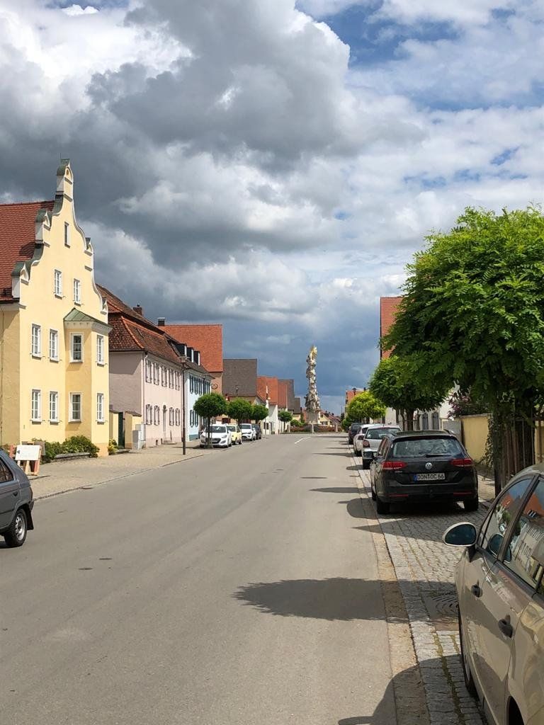
Wallerstein, Deutschland
In the heart of the Ries lies the market town of Wallerstein, characterized by its long history as the residence of the princes of Oettingen-Wallerstein. The town center is dominated by the well-known plague or trinity column and the parish church of St. Alban and captivates with its picturesque, historical structure. In the middle of the village rises the approx. 65 m high, former "Wallersteiner Felsen" with a wonderful panoramic view over the Ries.
86757 Wallerstein, Deutschland
48° 53' 13.1" N 10° 28' 37.1" E
48.8869717 10.4769657
• Head toward Von-Knebel-Straße on Weinstraße (DON12). Go for 193 m.
• Keep left onto Nördlinger Straße (DON12). Go for 240 m.
• Continue on DON12. Go for 628 m.
• Continue on Melchior-Meyr-Straße (DON12). Go for 397 m.
• Continue on DON12. Go for 547 m.
• Take the 2nd exit from roundabout onto B29 toward A7/Stuttgart/Aalen/Nördlingen-West/Historische Altstadt. Go for 1.9 km.
• Turn left toward Nördlingen-West/Historische Altstadt. Go for 1.3 km.
• Continue on Innerer Ring toward B466/Krankenhaus/Rieser Sportpark/B25. Go for 161 m.
• Turn left. Go for 11 m.
• Turn left toward Kaiserwiese. Go for 92 m.
• Turn right onto Kaiserwiese. Go for 67 m.
• Turn right. Go for 13 m.
• Arrive at your destination on the right.
☍
5,5 km
( 6 min.)
Nördlingen - Stellplatz Kaiserwiese
The large parking lot on Kaiserwiese is also a good stop before continuing on to Harburg. Nördlingen, located in the heart of the Ries meteorite crater, still has a medieval townscape with a completely preserved and fully accessible city wall , the only one of its kind in Germany. The historic cityscape is characterized by its landmark, the late Gothic hall church St. Georg with its 90 m high bell tower "Daniel", which can be climbed 365 days a year.
Innerer Ring, 86720, Nördlingen, Deutschland
48° 51' 19" N 10° 29' 1" E
48.8552778 10.4836111
• Head northeast. Go for 115 m.
• Turn right toward Innerer Ring. Go for 59 m.
• Turn left onto Innerer Ring. Go for 683 m.
• Continue on Lerchenstraße. Go for 423 m.
• Take the 2nd exit from roundabout onto Bürgermeister-Reiger-Straße. Go for 354 m.
• Take the 2nd exit from roundabout onto Adamstraße (B466) toward Augsburg/Donauwörth. Go for 357 m.
• Turn left onto Augsburger Straße (B466) toward Augsburg/B2/Donauwörth/Krankenhaus. Go for 1.6 km.
• Take ramp onto B25 toward Augsburg/B2/Donauwörth. Go for 15.1 km.
• Take ramp toward Wemding/Harburg. Go for 59 m.
• Turn right onto St2384. Go for 489 m.
• Turn right onto Grasstraße. Go for 87 m.
• Arrive at Grasstraße. Your destination is on the left.
☍
19,4 km
( 17 min.)
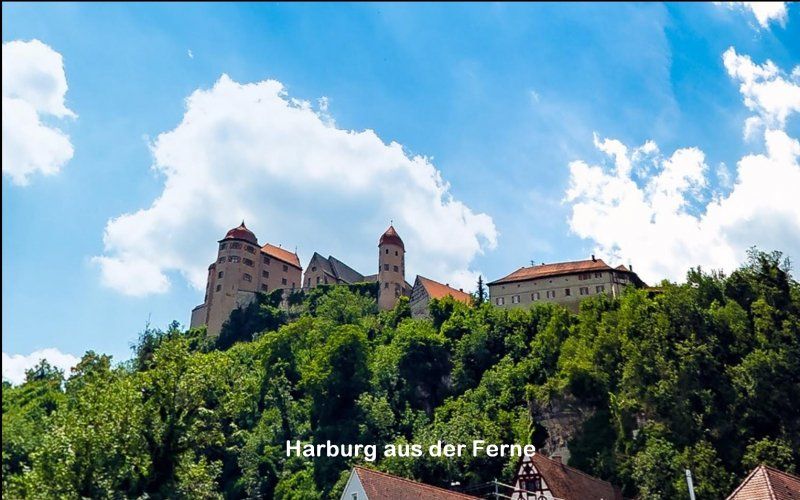
Wohnmobilstellplatz Harburg
The town of Harburg is located in the Wörnitz valley between the Swabian and Franconian Jura. The winding old town with half-timbered buildings and baroque gabled houses fits between the Wörnitz and the Burgberg. The mighty Harburg, one of the best-preserved castles in Germany, towers over the city and is now owned by the not-for-profit Prince of Oettingen-Wallerstein Cultural Foundation.
Grasstraße, 86655, Harburg, Deutschland
48° 47' 4.6" N 10° 41' 34.3" E
48.7845997 10.6928647
• Head northwest on Grasstraße. Go for 87 m.
• Turn left onto Grasstraße (St2384). Go for 489 m.
• Take left ramp onto B25. Go for 8.5 km.
• Take ramp onto Nürnberger Straße toward Nürnberg/B2/Donauwörth-Stadtmitte. Go for 1.2 km.
• Continue on Berger Allee. Go for 653 m.
• Continue on Pflegstraße. Go for 331 m.
• Turn left onto Reichsstraße. Go for 118 m.
• Turn right onto Augsburger Botengasse. Go for 64 m.
• Turn left onto Kronengasse. Go for 13 m.
• Arrive at Kronengasse. Your destination is on the right.
☍
11,5 km
( 10 min.)
Day
Donauwörth, Deutschland
At the mouth of the Wörnitz into the Danube lies the former Free Imperial City of Donauwörth, which arose from a fishing settlement on the Wörnitz island "Ried". The magnificent axis of the historic old town between the town hall and the Fuggerhaus is the Reichsstrasse with its impressive patrician houses. It is one of the most beautiful streets in southern Germany.
86609 Donauwörth, Deutschland
48° 43' 6.9" N 10° 46' 40.1" E
48.7185826 10.7778041
• Head toward Hirtenberg on Kronengasse. Go for 218 m.
• Turn left onto Spitalstraße. Go for 23 m.
• Turn sharp right onto Kapellstraße. Go for 354 m.
• Continue on Augsburger Straße (St2215). Go for 845 m.
• Take ramp onto DON28. Go for 878 m.
• Turn left and take ramp onto Südspange (B16). Go for 9.9 km.
• Take ramp toward Rain-West/Feldheim/Stadtmitte/Gewerbegebiet Rain-West. Go for 193 m.
• Continue on Donauwörther Straße. Go for 1.5 km.
• Continue on Hauptstraße. Go for 497 m.
• Turn right. Go for 21 m.
• Turn left. Go for 59 m.
• Turn left. Go for 16 m.
• Arrive at your destination on the right.
☍
14,5 km
( 15 min.)
Rain, Deutschland
The Lech city was founded more than 750 years as northwestern stronghold of Old Bavaria. Evidence of the early fortress such as the remains of the city wall or the lieutenant's hill are still visible. The main street beckons with its unique, listed ensemble of town houses from the 17th and 18th centuries. The Rococo town hall impresses with its majestic construction. The Tilly memorial commemorates the former general of the Thirty Years' War, Johann Tserclaes Tilly, who was badly wounded at the "Battle of Rain" in 1632 and died of the consequences.
86641 Rain, Deutschland
48° 41' 24.6" N 10° 55' 15.2" E
48.6901541 10.9208893
• Head south. Go for 16 m.
• Turn right toward Hauptstraße. Go for 80 m.
• Turn right onto Hauptstraße. Go for 63 m.
• Continue on Neuburger Straße (St2047). Go for 36 m.
• Turn right onto Münchner Straße (St2047). Go for 1.9 km.
• Take the 2nd exit from roundabout onto St2047. Go for 3.7 km.
• Continue on St2381. Go for 2.0 km.
• Continue on Rainer Straße (St2381). Go for 282 m.
• Continue on Thierhaupter Straße (St2381). Go for 427 m.
• Continue on St2381. Go for 3.0 km.
• Continue on Königsbrunn (St2381). Go for 29 m.
• Continue on St2381. Go for 215 m.
• Continue on Königsbrunn (St2381). Go for 133 m.
• Continue on St2381. Go for 1.5 km.
• Continue on St2045. Go for 494 m.
• Take the 2nd exit from roundabout onto Meitinger Straße (St2045). Go for 4.4 km.
• Take the 1st exit from roundabout onto B2 toward A8/Augsburg. Go for 18.4 km.
• Continue on B17. Go for 4.8 km.
• Take ramp toward Memmingen/A.-Zentrum/A-Kriegshaber-Süd/A-Pfersee-Nord/Zentrum/Pfersee-Nord. Go for 258 m.
• Turn left onto Bürgermeister-Ackermann-Straße toward Zentrum/Pfersee-Nord. Go for 1.8 km.
• Turn right. Go for 87 m.
• Arrive at your destination on the right.
☍
43,7 km
( 33 min.)
Augsburg - Stellplatz an der Wertach
The city founded under the Roman emperor Augustus more than 2000 years ago is one of the oldest cities in Germany. The Free Imperial City reached its peak of economic prosperity in the 15th and 16th centuries through long-distance trade and the banking transactions of the Fugger and Welser. The historic city center with the splendid Maximilianstrasse and the Renaissance and Baroque facades of the palaces and town houses is a reflection of those glorious times.
Bürgermeister-Ackermann-Straße 1, 86152, Augsburg, Deutschland
48° 22' 10" N 10° 52' 39" E
48.3694444 10.8775000
• Head southwest. Go for 182 m.
• Turn sharp right onto Holzbachstraße. Go for 377 m.
• Continue on Perzheimstraße. Go for 604 m.
• Continue on Stadionstraße. Go for 725 m.
• Continue on Gabelsbergerstraße. Go for 876 m.
• Turn left and take ramp onto Oberbürgermeister-Müller-Ring (B17/B300) toward Landsberg/A.-Süd/Messe. Go for 35.2 km.
• Keep left onto B17 toward München. Go for 155 m.
• Take the 3rd exit from roundabout onto St2054 toward Landsberg/Krankenhaus/Gewerbegebiet Frauenwald/Gewerbegebiet Lechwiesen. Go for 1.9 km.
• Turn left onto Holzhauser Straße. Go for 558 m.
• Turn left onto Hindenburgring. Go for 92 m.
• Turn right onto Spöttinger Straße. Go for 145 m.
• Take the 3rd exit from roundabout onto Oberbürgermeister-Hamberger-Platz. Go for 241 m.
• Continue on Europaplatz. Go for 90 m.
• Turn right onto Von-Kühlmann-Straße. Go for 90 m.
• Arrive at Von-Kühlmann-Straße.
☍
41,2 km
( 28 min.)
Day
Landsberg am Lech, Deutschland
The city of Landsberg am Lech - founded by Henry the Lion - can look back on more than 850 years of history. The centerpiece of the old town between the Lech and the banks of the Lech is the wide market square - dominated by the Schmalzturm - with its self-confident town houses and the beautiful stucco facade of Dominikus Zimmermann's town hall.
86899 Landsberg am Lech, Deutschland
48° 3' 2.8" N 10° 52' 13.3" E
48.0507830 10.8703515
• Head toward An der Papiermühle on Von-Kühlmann-Straße. Go for 502 m.
• Turn right onto Katharinenstraße (St2054). Go for 933 m.
• Turn left onto Katharinenstraße. Go for 108 m.
• Turn left onto Schongauer Straße. Go for 1.8 km.
• Continue on Schongauer Straße toward Schongau. Go for 115 m.
• Take ramp onto B17. Go for 20.3 km.
• Arrive at B17.
☍
23,7 km
( 17 min.)
Hohenfurch, Deutschland
In the Schönachtal, surrounded by meadows and forests, Hohenfurch (1600 inhabitants) is the gateway to the Pfaffenwinkel. Here the traveler can enjoy the cozy summer freshness and the view of the Alpine chain in a rural setting. A generous network of cycling and hiking trails as well as other leisure activities such as horse riding, tennis, cross-country skiing etc. invite you to spend a holiday.
47° 50' 55.3" N 10° 53' 51.5" E
47.8486842 10.8976462
• Head south on B17. Go for 1.0 km.
• Turn left toward Schongau Krankenhaus-Nord/Gewerbegebiet Hohenfurch Tal. Go for 476 m.
• Continue on Augsburger Straße. Go for 2.0 km.
• Take the 3rd exit from roundabout onto Sonnenstraße. Go for 703 m.
• Continue on Bahnhofstraße (St2014). Go for 630 m.
• Turn right onto Lechuferstraße. Go for 353 m.
• Arrive at Lechuferstraße. Your destination is on the left.
☍
5,2 km
( 6 min.)
Schongau - Stellplatz am Festplatz
The medieval cityscape with its walls, gates and towers is vivid proof of Schongau's rich history. At the turn of the 13th century, the city was the center of administration, Wittelsbach's secondary residence and Bavarian border fortress on the Swabian Lech. The baroque parish church Mariae Himmelfahrt is artistically designed.
Lechuferstraße, 86956, Schongau, Deutschland
47° 48' 30" N 10° 53' 55" E
47.8083333 10.8986111
• Head southwest on Lechuferstraße. Go for 33 m.
• Turn right. Go for 13 m.
• Turn right toward Lechuferstraße. Go for 169 m.
• Turn slightly left onto Lechuferstraße. Go for 227 m.
• Turn right onto Bahnhofstraße (St2014). Go for 27 m.
• Turn right onto Peitinger Straße (St2014). Go for 285 m.
• Take the 2nd exit from roundabout onto Peitinger Straße (St2014). Go for 801 m.
• Continue on Peitinger Straße. Go for 463 m.
• Continue on Schongauer Straße. Go for 453 m.
• Continue on Schongauer Straße. Go for 741 m.
• Take the 1st exit from roundabout onto Schongauer Straße toward A96/Garmisch-Partenk./Füssen/Ortsmitte. Go for 205 m.
• Turn right onto Hauptplatz. Go for 150 m.
• Continue on Ammergauer Straße. Go for 178 m.
• Turn left onto Azamstraße. Go for 261 m.
• Continue on Sparkassenplatz. Go for 265 m.
• Arrive at Friedhofstraße. Your destination is on the right.
☍
4,3 km
( 6 min.)
Peiting, Deutschland
The Peiting market, located between the rivers Ammer and Lech, is one of the oldest settlements in Lech and Ammerland and has retained its village charm. The parish church of St. Michael and the museum in Klösterle are worth seeing. Good weather tip: drive to Hohenpeißenberg.
47° 47' 38.8" N 10° 55' 49.1" E
47.7941166 10.9303033
• Head west on Friedhofstraße. Go for 265 m.
• Continue on Azamstraße. Go for 261 m.
• Turn right onto Ammergauer Straße. Go for 106 m.
• Turn left onto Meierstraße. Go for 174 m.
• Turn left onto Füssener Straße. Go for 12.5 km.
• Arrive at Schongauer Straße (B17).
☍
13,3 km
( 13 min.)
Steingaden, Deutschland
86989 Steingaden, Deutschland
47° 42' 9.1" N 10° 51' 39.1" E
47.7025337 10.8608513
• Head southwest on Schongauer Straße (B17). Go for 7 m.
• Turn right toward Schongauer Straße. Go for 53 m.
• Turn slightly right onto Schongauer Straße. Go for 62 m.
• Turn left onto Schongauer Straße (B17). Go for 161 m.
• Turn right onto Ammergauer Straße (St2059) toward Garmisch-P./B23/Wildsteig/Wieskirche. Go for 2.7 km.
• Turn right onto St2559. Go for 2.5 km.
• Continue on Wies. Go for 72 m.
• Turn left onto Wies. Go for 165 m.
• Arrive at Wies. Your destination is on the left.
☍
5,7 km
( 7 min.)
Wieskirche, Wies, Steingaden, Deutschland
The approved resort Steingaden in southern Pfaffenwinkel at the intersection of the Romantic Road and the German Alpine Road is known for the world famous rococo church "the Scourged Savior of the meadow." (Wieskirche - UNESC0 World Heritage) No less impressive is the historic Welfenmünster with its Romanesque cloister wing.
Wieskirche, 86989 Steingaden, Deutschland
47° 40' 49.8" N 10° 54' 1.9" E
47.6805029 10.9005153
• Head northwest on Wies. Go for 165 m.
• Turn right onto Wies. Go for 72 m.
• Continue on St2559. Go for 77 m.
• Continue on St2559. Go for 2.4 km.
• Turn right onto Kohlhofen (St2059). Go for 3.2 km.
• Turn right onto Kirchbergstraße (WM25). Go for 400 m.
• Arrive at Kirchbergstraße (WM25). Your destination is on the left.
☍
6,3 km
( 7 min.)
Wildsteig, Deutschland
In the middle of nature and landscape protection areas, embedded in the hilly pre-alpine landscape with its bogs and lakes, framed by the Ammergau and Allgäu mountains, lies the state-recognized resort with numerous districts and hamlets. An ideal cycling and hiking area for everyone looking for rest and relaxation. Official DSV Nordic Walking Center.
82409 Wildsteig, Deutschland
47° 42' 7" N 10° 56' 2.7" E
47.7019485 10.9340732
• Head south on Kirchbergstraße (WM25).
• Turn right onto Auernheimer Weg. Go for 285 m.
• Turn slightly left onto Kirchbergstraße (WM25). Go for 253 m.
• Turn right onto Ammergauer Straße (St2059). Go for 3.2 km.
• Take the 1st exit from roundabout onto B23. Go for 2.4 km.
• Turn left onto Dorfstraße toward Bad Bayersoien-Nord. Go for 364 m.
• Arrive at Dorfstraße.
☍
6,5 km
( 7 min.)
Bad Bayersoien, Deutschland
In earlier times, Bayersoien was the Roman station "Ad Seun" near the lakes (15 BC). Numerous finds suggest that the place and name are probably of Celtic origin. Later the place was called Sewen, Sevn and Soyen. And since 1808 Bayersoyen and since 1825 Bayersoien.
The favorable location on the trade route between Schongau and Ammergau then became the decisive factor for the development from a farming village to a stopover characterized by craftsmen and hostels. Soyen retained the typical appearance of a street village on both sides of this trade route until the 20th century.
82435 Bad Bayersoien, Deutschland
47° 41' 33.2" N 10° 59' 31.1" E
47.6925621 10.9919727
• Head toward Waidaweg on Dorfstraße. Go for 364 m.
• Turn left onto B23. Go for 12.9 km.
• Turn left onto Rottenbucher Straße toward Oberammergau-Nord. Go for 90 m.
• Continue on Rottenbucher Straße. Go for 85 m.
• Continue on Rottenbucher Straße. Go for 470 m.
• Continue on Bahnhofstraße. Go for 418 m.
• Turn left onto Dorfstraße. Go for 283 m.
• Arrive at Dorfstraße. Your destination is on the right.
☍
14,7 km
( 13 min.)
Oberammergau, Deutschland
In the 19th century, Oberammergau became world famous with its Passion Play, which has been performed every ten years since 1634 after the plague was practiced in 1633. There were slight shifts due to various wars.
The place in the Ammergau Alps is also known because of the numerous "Herrgottsschnitzer". The carving of religious motifs goes back to the 16th century. The townscape of Oberammergau is particularly characterized by the so-called "Ventillmalerei" (facade painting).
82487 Oberammergau, Deutschland
47° 35' 53" N 11° 3' 51" E
47.5980537 11.0641725
• Head toward Verlegergasse on Dorfstraße. Go for 249 m.
• Continue on Ettaler Straße. Go for 1.4 km.
• Turn left onto B23 toward Garmisch-Partenk./Oberau/Ettal. Go for 8.5 km.
• Keep right onto Ettaler Straße (B23) toward Garmisch-Part. Go for 1.3 km.
• Take ramp onto B2 toward Garmisch-Partenkirchen. Go for 5.0 km.
• Take ramp onto B23 toward Fernpass/Reutte/Grainau/Garmisch/Burgrain. Go for 1.4 km.
• Continue on B23. Go for 79 m.
• Take the 2nd exit from roundabout onto B23 toward Fernpass/Reutte/Grainau. Go for 5.3 km.
• Arrive at Griesener Straße (B23). Your destination is on the left.
☍
23,2 km
( 25 min.)
Grainau Wohnmobilhafen Zugspitzblick
Whether hiking in summer or skiing in winter - Grainau is the perfect travel destination regardless of the season. Located at the foot of the Zugspitze and just a few kilometers from Garmisch-Partenkirchen, you can experience a dream vacation in our Zugspitzdorf.
Griesener Straße 4, 82491, Grainau, Deutschland
47° 28' 47" N 11° 3' 14" E
47.4797222 11.0538889
• Head west on Griesener Straße (B23).
• Arrive at Griesener Straße (B23). Your destination is on the left.
☍
Distance not available
(Duration not available)
Day
Ruhetag Wohnmobilhafen Zugspitzblick
With a nice bet, ride to the Zugspitze.
Germany's highest mountain at 2964 m - the highlight of your trip to the Romantic Road. Drive to the Zugspitze and almost all of Europe is at your feet. Enjoy the incomparable view of the countless Alpine peaks of Germany, Austria, Italy and Switzerland. The Zugspitze offers you experiences like no other mountain!
Griesener Straße 4, 82491, Grainau, Deutschland
47° 28' 47" N 11° 3' 14" E
47.4797222 11.0538889
• Head west on Griesener Straße (B23). Go for 193 m.
• Turn left onto Schmölzstraße toward Obergrainau. Go for 22 m.
• Turn left onto Am Schmiedenrain. Go for 34 m.
• Continue on Griesener Straße (B23). Go for 5.4 km.
• Take the 1st exit from roundabout onto B23 toward A95/B2/Farchant. Go for 122 m.
• Turn left onto B23. Go for 1.1 km.
• Take ramp onto B2. Go for 5.1 km.
• Take ramp onto Münchner Straße (B23) toward Augsburg/Oberammergau/Ettal/Oberau-Süd. Go for 1.1 km.
• Keep left onto Ettaler Straße (B23) toward Augsburg/Oberammergau/Schloß Linderhof/Ettal. Go for 6.8 km.
• Turn left onto St2060 toward Reutte/Graswang/Linderhof. Go for 9.8 km.
• Turn right onto Linderhof. Go for 391 m.
• Turn left onto Linderhof. Go for 12 m.
• Turn right onto Linderhof. Go for 41 m.
• Turn right onto Linderhof. Go for 110 m.
• Arrive at Linderhof.
☍
30,2 km
( 30 min.)
Day
Schloss Linderhof, Linderhof, Ettal, Deutschland
Linderhof Castle in the Ammergau Alps is the smallest of the three castles of Ludwig II and is considered the favorite castle of the “fairy tale king. With the construction of the castle, the magnificent castle garden was created between 1874 and 1880.
Linderhof 12, 82488 Ettal, Deutschland
47° 34' 17.8" N 10° 57' 39" E
47.5716123 10.9608242
• Head east on Linderhof. Go for 49 m.
• Turn right onto Linderhof. Go for 120 m.
• Turn left onto Linderhof. Go for 391 m.
• Turn right onto Linderhof (St2060). Go for 6.8 km.
• Continue on Planseestraße (L255). Go for 17.8 km.
• Take the 2nd exit from roundabout onto Kreckelmoosstraße (L255). Go for 395 m.
• Turn right and take ramp onto Fernpassstraße (B179) toward Deutschland. Go for 11.1 km.
• Take ramp toward Vils/Augsburg/Pfronten. Go for 217 m.
• Take the 1st exit from roundabout onto Weißhausstraße (L396) toward Augsburg/Füssen/Pinswang. Go for 2.7 km.
• Continue on Tiroler Straße (B17). Go for 2.1 km.
• Turn right onto Füssener Straße (B17) toward München/Augsburg/Schwangau/Königsschlösser. Go for 396 m.
• Turn right onto St2008 toward Hohenschwangau/Königsschlösser. Go for 2.4 km.
• Turn right onto Alpseestraße. Go for 287 m.
• Turn left onto Neuschwansteinstraße. Go for 256 m.
• Arrive at Neuschwansteinstraße.
☍
45,0 km
( 43 min.)
Neuschwanstein Schloss, Neuschwansteinstraße, Schwangau, Deutschland
Schwangau is the village of the royal castles, surrounded by 4 lakes and the Ammer Mountains nature reserve. it has about 120 km of walking and hiking trails. The world-famous royal castles Neuschwanstein and Hohenschwangau and the Roman Villa (Roman excavations) are in close proximity. If you don't have enough of the Zugspitze yet, you can take the cable car up to the 1720 m high Tegelberg.
Neuschwansteinstraße 20, 87645 Schwangau, Deutschland
47° 33' 27.3" N 10° 44' 59.3" E
47.5575736 10.7498012
• Head toward Alpseestraße on Neuschwansteinstraße. Go for 256 m.
• Turn right onto Alpseestraße. Go for 287 m.
• Turn left onto Parkstraße (St2008). Go for 2.4 km.
• Turn left onto Füssener Straße (B17). Go for 378 m.
• Continue on König-Ludwig-Brücke (B16). Go for 924 m.
• Turn right onto Augsburger Straße (B16) toward A7/Kaufbeuren/Kempten/B310. Go for 1.3 km.
• Take the 2nd exit from roundabout onto Hopfener Straße (St2008) toward Seeg/Hopfen/Fachklinik/Enzensberg. Go for 350 m.
• Turn left onto Abt-Hafner-Straße. Go for 226 m.
• Turn left onto Abt-Hafner-Straße. Go for 17 m.
• Turn left. Go for 13 m.
• Arrive at your destination on the right.
☍
6,1 km
( 10 min.)
Stellplatz Füssen/Camper's Stop
The romantic soul of Bavaria: Immediately on the edge of the Alps in one of the most beautiful Bavarian holiday regions at the foot of Neuschwanstein Castle, Bavaria's highest town lies at an altitude of 800 - 1200 m. The late medieval town center with the High Castle and St. Mang Monastery is home to numerous art treasures and monuments from the almost 2000-year history of Füssen. Sightseeing, strolling and relaxation in a romantic atmosphere.
Abt-Hafner-Straße 9, 87629, Füssen, Deutschland
47° 34' 56" N 10° 42' 3" E
47.5822222 10.7008333
• Head toward Abt-Hafner-Straße. Go for 13 m.
• Turn right onto Abt-Hafner-Straße. Go for 17 m.
• Turn right onto Abt-Hafner-Straße. Go for 226 m.
• Turn right onto Hopfener Straße (St2008). Go for 319 m.
• Take the 2nd exit from roundabout onto Augsburger Straße (B16) toward A7/Ulm/Innsbruck/Kaufbeuren/Kempten/B310. Go for 348 m.
• Turn left onto B310 toward Ulm/A7/Innsbruck/Kempten/Pfronten/Weißensee/Gewerbegebiet Füssen-West. Go for 3.5 km.
• Take ramp onto A7. Go for 16.3 km.
• Take exit 138 toward Nesselwang/Marktoberdorf/Seeg/Rückholz. Go for 286 m.
• Turn right onto OAL23 toward Seeg/Nesselwang. Go for 2.1 km.
• Take the 2nd exit from roundabout onto OAL23. Go for 1.1 km.
• Turn left onto Lindenstraße. Go for 28 m.
• Arrive at Lindenstraße.
☍
24,3 km
( 17 min.)
Day
Nesselwang, Deutschland
The market town with the striking tower of the parish church of St. Andreas is framed by green peaks, blue lakes and colorful flower meadows. You can also see the local mountain, the Alpspitze, on whose slope the famous pilgrimage church of Maria Trost is located.
The Alpspitzbahn and the parking space invite you to linger.
87484 Nesselwang, Deutschland
47° 37' 25.1" N 10° 30' 4.3" E
47.6236401 10.5011931
• Head toward Poststraße on Lindenstraße. Go for 186 m.
• Turn right onto Lindenstraße. Go for 88 m.
• Turn right onto Hauptstraße (St2520). Go for 3.7 km.
• Take the 1st exit from roundabout onto B310 toward A7/Kempten. Go for 2.2 km.
• Take ramp onto A7 toward Ulm/Kempten. Go for 9.0 km.
• Take exit 136 toward Lindau/Oberstdorf/Sonthofen/B12 onto A980. Go for 6.0 km.
• Continue on B12. Go for 15.3 km.
• Take ramp toward Weitnau/Oberstaufen/Missen-Wilhams. Go for 703 m.
• Turn left onto Ritzensonnenhalb (OA7). Go for 518 m.
• Continue on Ritzen (OA7). Go for 150 m.
• Continue on Hoheneggstraße (OA7). Go for 457 m.
• Turn right onto Marktstraße. Go for 13 m.
• Turn slightly left onto Braut- und Bahrweg. Go for 29 m.
• Arrive at Braut- und Bahrweg. Your destination is on the left.
☍
38,4 km
( 25 min.)
Weitnau, Deutschland
As with many municipalities in the Allgäu, tourism is also an important source of income in Weitnau. Weitnau is a popular holiday destination in summer and winter alike. There are extensive walking and hiking trails, cross-country trails and historical sights. The municipality has been a recognized climatic health resort since 13 December 2005. The Allgäu cycle path also runs through the town.
87480 Weitnau, Deutschland
47° 38' 26.5" N 10° 7' 32.9" E
47.6406911 10.1258134
• Head toward Kirchstraße on Braut- und Bahrweg. Go for 108 m.
• Turn right onto Braut- und Bahrweg. Go for 49 m.
• Turn right onto Franz-von-Miller-Straße. Go for 205 m.
• Turn right onto Hauchenbergweg. Go for 56 m.
• Turn left onto Marktstraße. Go for 10 m.
• Turn right onto Hauchenbergweg. Go for 33 m.
• Continue toward Hoheneggstraße/OA7. Go for 63 m.
• Turn left onto Hoheneggstraße (OA7). Go for 365 m.
• Continue on Ritzen (OA7). Go for 150 m.
• Continue on Ritzensonnenhalb (OA7). Go for 2.3 km.
• Turn left onto B12. Go for 7.5 km.
• Turn right onto L318 toward Leutkirch/Neutrauchburg/Isny-Ost/Gewerbegebiet Isny. Go for 116 m.
• Take the 2nd exit from roundabout onto L318. Go for 1.7 km.
• Take the 3rd exit from roundabout onto Achener Weg. Go for 680 m.
• Take the 3rd exit from roundabout onto Bahnhofstraße. Go for 165 m.
• Continue on Schwanenweg. Go for 197 m.
• Turn left onto Untere Achstraße. Go for 108 m.
• Turn right onto Bahnhofstraße. Go for 55 m.
• Arrive at Bahnhofstraße. Your destination is on the left.
☍
13,9 km
( 17 min.)
Isny im Allgäu, Deutschland
Mighty towers against a blue sky and a picturesque Alpine panorama: Isny im Allgäu impresses from afar with its historic skyline. The eventful city history goes back almost 1,000 years - from the first documentary mention in 1096 to the time as a flourishing Free Imperial City to the present day.
88316 Isny im Allgäu, Deutschland
47° 41' 41.9" N 10° 2' 31.1" E
47.6949747 10.0419676
• Head south on Bahnhofstraße.
• Turn right onto Kronengasse. Go for 74 m.
• Turn left onto Unterer Grabenweg. Go for 24 m.
• Turn right onto Unterer Grabenweg. Go for 14 m.
• Keep right onto Unterer Grabenweg. Go for 93 m.
• Turn right onto Untere Achstraße. Go for 81 m.
• Continue on Schwanenweg. Go for 197 m.
• Continue on Bahnhofstraße. Go for 120 m.
• Take the 3rd exit from roundabout onto Neutrauchburger Straße. Go for 1.7 km.
• Take the 2nd exit from roundabout onto L265. Go for 6.6 km.
• Turn right onto Kißlegger Straße (L265). Go for 7.5 km.
• Pass 3 roundabouts and continue on Wangener Straße (L265). Go for 5.1 km.
• Turn right onto Schloßstraße (L265). Go for 828 m.
• Turn left onto L330. Go for 8.2 km.
• Arrive at Rötenbacher Straße (L315). Your destination is on the right.
☍
30,6 km
( 31 min.)
Wolfegg, Deutschland
The municipality of Wolfegg is a climatic health resort and is located in Westallgäu, the hilly Alpine foothills. It is characterized by its intensive grassland farming and its ice age drumlins. This landscape is well known as a holiday region due to dozens of ponds and swimming lakes, the pre-alpine climate and not least due to the Upper Swabian Baroque.
47° 49' 5" N 9° 47' 41.3" E
47.8180653 9.7948066
• Head toward Gartenstraße on Rötenbacher Straße (L315). Go for 288 m.
• Turn right onto Alttanner Straße (L317). Go for 1.3 km.
• Turn left onto Alttanner Straße (L316). Go for 5.6 km.
• Turn left onto Roßberg (L314). Go for 87 m.
• Turn right onto Roßberg (L316). Go for 6.3 km.
• Turn right onto Unterurbacher Weg. Go for 322 m.
• Turn right. Go for 35 m.
• Arrive at your destination on the left.
☍
14,0 km
( 14 min.)
Bad Waldsee Stellplatz an der Waldsee-Therme
The parking space at the Hymer headquarters is of course also an option. A visit to the Erwin Hymer Museum shows the full range of our way of traveling.
Unterurbacher Weg, 88339, Bad Waldsee, Deutschland
47° 54' 50" N 9° 45' 38" E
47.9138889 9.7605556
• Head northeast. Go for 35 m.
• Turn left onto Unterurbacher Weg. Go for 322 m.
• Turn right onto Friedhofstraße (L316). Go for 180 m.
• Turn right onto Am Stadtgraben (L300). Go for 97 m.
• Continue on Muschgaystraße (L300). Go for 96 m.
• Turn right onto Wurzacher Straße (L300). Go for 602 m.
• Turn left onto Schützenstraße. Go for 697 m.
• Turn right onto Biberacher Straße (L300). Go for 923 m.
• Take ramp onto B30 toward Ulm/Biberach. Go for 17.4 km.
• Take ramp toward B465/Biberach/Ehingen/B312/Reutlingen/Memmingen/Jordanbad. Go for 255 m.
• Take the 3rd exit from roundabout onto Waldseer Straße (B312) toward Friedrichshafen/B30/Biberach-Süd/Gewerbegebiet Waldseer Straße. Go for 1.8 km.
• Take the 2nd exit from roundabout onto Waldseer Straße (B312). Go for 1.4 km.
• Continue on Waldseer Straße. Go for 196 m.
• Arrive at Waldseer Straße. Your destination is on the right.
☍
24,1 km
( 24 min.)
Day
Biberach an der Riß, Deutschland
Biberach an der Riß looks back on a rich historical past: It is located in northern Upper Swabia, about 40 kilometers south of Ulm and 40 kilometers west of Memmingen. The city is on both sides of the Riß, which gave its name to an ice age, and today Biberach is an emerging business location. The global company Boehringer Ingelheim is located here as well as the brand company Liebherr, which produces much more than cranes, or the global high-tech company Handtmann. The Biberach University of Applied Sciences for Construction and Economics is one of the best in Germany and has also had a course in biotechnology for several years.
48° 5' 42.5" N 9° 47' 24.5" E
48.0951473 9.7901525
• Head north on Waldseer Straße. Go for 117 m.
• Turn right onto Zeppelinring. Go for 543 m.
• Continue on Bismarckring (B465). Go for 398 m.
• Turn right onto Ehinger Straße (B465). Go for 1.6 km.
• Continue on Biberacher Straße (B465). Go for 453 m.
• Take the 2nd exit from roundabout onto Biberacher Straße (B465) toward Ehingen/Warthausen. Go for 370 m.
• Continue on Ehinger Straße (B465). Go for 31 m.
• Continue on Biberacher Straße (B465). Go for 918 m.
• Pass 2 roundabouts and continue on B465. Go for 17.7 km.
• Take the 3rd exit from roundabout onto Mühlweg (B465) toward Stuttgart/Ulm. Go for 1.6 km.
• Turn right onto B311/B465 toward Ulm/Stuttgart/Blaubeuren/Ehingen. Go for 556 m.
• Take ramp toward Stuttgart/Münsingen/Ehingen Stadtmitte/B465. Go for 132 m.
• Take the 1st exit from roundabout onto Münsinger Straße (B465). Go for 195 m.
• Take the 2nd exit from roundabout onto Münsinger Straße (B465). Go for 5.6 km.
• Turn left onto Alte Heerstraße. Go for 1.5 km.
• Arrive at your destination.
☍
31,7 km
( 34 min.)
Ehingen (Donau), Deutschland
43 beers, 4 breweries, 1 city
The beer culture town of Ehingen has an almost unique experience on the subject of beer culture in Baden-Württemberg! (Berg brewery, Gasthof brewery Schwanen, brewery Gasthof Rössle, brewery Schwert). If you want to indulge here, there are various parking spaces (e.g. directly at the Berg brewery).
89584 Ehingen (Donau), Deutschland
48° 17' 34.4" N 9° 39' 40.4" E
48.2928997 9.6612347
• Head northwest. Go for 1.1 km.
• Continue on Alte Heerstraße. Go for 389 m.
• Turn left onto Alte Heerstraße (B465). Go for 227 m.
• Turn right onto Brieler Straße (K7341) toward Weilersteußlingen/Grötzingen/Briel. Go for 363 m.
• Continue on K7341. Go for 1.3 km.
• Continue on Grötzinger Straße (K7341). Go for 483 m.
• Continue on K7341. Go for 2.3 km.
• Turn left onto Weilerstraße (K7335). Go for 184 m.
• Turn right onto Lange Straße (K7332). Go for 153 m.
• Turn right onto Grießtalstraße (K7334). Go for 855 m.
• Continue on K7334. Go for 4.9 km.
• Turn left onto B492. Go for 9.1 km.
• Keep right onto Bahnhofstraße (B28) toward Ulm/Stadtmitte/Blautopf/Kloster. Go for 229 m.
• Turn left onto Karlstraße. Go for 341 m.
• Turn left onto Zeppelinstraße. Go for 80 m.
• Turn left onto Weilersteig. Go for 232 m.
• Turn right onto Gottlieb-Haug-Straße. Go for 113 m.
• Turn left onto Reichlensbergweg. Go for 39 m.
• Turn slightly right onto Matthäus-Hipp-Weg. Go for 166 m.
• Continue on Auf dem Barmen. Go for 519 m.
• Arrive at Auf dem Barmen. Your destination is on the right.
☍
23,1 km
( 26 min.)
Blaubeuren, Deutschland
Monastery, Blautopf and a parking space are the characteristics of the city on the Ach and the Blau. The location on what was then the main connection between Augsburg and Strasbourg via Tübingen favored the development, but the city's prosperity, which is reflected in its buildings, is also closely linked to the history of the monastery. Blaubeuren attracted people as a market town as early as the 11th century. At every turn, visitors encounter the late Middle Ages on the winding paths through the old town of Blaubeuren: magnificent half-timbered houses and picturesque corners, unobtrusive and therefore all the more authentic.
's leit a Klötzle lead at Blaubeura, same at Blaubeura leit a Klötzle lead. (Eduard Mörike) .-))
89143 Blaubeuren, Deutschland
48° 24' 26.3" N 9° 47' 0.8" E
48.4073041 9.7835451
• Head toward Matthäus-Hipp-Weg on Auf dem Barmen. Go for 519 m.
• Turn right onto Matthäus-Hipp-Weg. Go for 18 m.
• Continue on Reichlensbergweg. Go for 104 m.
• Turn right toward Weilersteig. Go for 106 m.
• Continue on Weilersteig. Go for 311 m.
• Turn right onto Zeppelinstraße. Go for 80 m.
• Turn right onto Karlstraße. Go for 341 m.
• Turn right onto Bahnhofstraße (B28). Go for 3.7 km.
• Turn right onto L1230 toward A8/Merklingen/Berghülen. Go for 8.7 km.
• Turn right onto L1230 toward A8/Geislingen/Merklingen. Go for 7.2 km.
• Turn left onto Aicher Straße (L1230) toward Geislingen/Türkheim/Bad Ditzenbach/Authausen. Go for 4.7 km.
• Take the 1st exit from roundabout onto Nellinger Straße (L1230). Go for 6.1 km.
• Turn left onto Wiesensteiger Straße (L1231). Go for 169 m.
• Turn right onto Paulinenstraße. Go for 487 m.
• Turn right onto Paulinenstraße. Go for 140 m.
• Turn right onto Tälesbahnstraße. Go for 45 m.
• Turn slightly left onto Tälesbahnstraße. Go for 62 m.
• Continue on Lessingstraße. Go for 103 m.
• Turn right onto Überkinger Straße (B466). Go for 61 m.
• Turn left onto Stuttgarter Straße (B10) toward Stuttgart/Göppingen. Go for 6.9 km.
• Take ramp onto B466 toward Heidenheim/Donzdorf/Süßen-Ost. Go for 3.5 km.
• Take the 2nd exit from roundabout onto B466 toward Reichenbach u.R. Go for 3.0 km.
• Take the 3rd exit from roundabout onto Hauptstraße (L1159) toward Schwäbisch Gmünd/Winzingen. Go for 1.3 km.
• Pass 2 roundabouts and continue on Kaiserbergstraße (L1159). Go for 10.1 km.
• Take the 2nd exit from roundabout onto Einhornstraße (L1075). Go for 897 m.
• Take the 2nd exit from roundabout onto Einhornstraße (L1075). Go for 1.4 km.
• Continue on Rechbergstraße (L1160). Go for 451 m.
• Take the 2nd exit from roundabout. Go for 55 m.
• Turn right onto Klarenbergstraße. Go for 57 m.
• Continue on Sebaldplatz. Go for 117 m.
• Turn left onto Untere Zeiselbergstraße. Go for 206 m.
• Continue on Königsturmstraße. Go for 474 m.
• Take the 3rd exit from roundabout onto Baldungstraße. Go for 156 m.
• Turn right onto Vordere Schmiedgasse (L1075). Go for 238 m.
• Continue on Aalener Straße (B298). Go for 499 m.
• Turn left onto Schießtalstraße. Go for 318 m.
• Continue on Richard-Bullinger-Straße. Go for 37 m.
• Turn left. Go for 160 m.
• Turn left. Go for 33 m.
• Arrive at your destination on the left.
☍
62,9 km
(1 hrs. 14 min.)
Schwäbisch Gmünd - Stellplatz am Freibad
See the beginning of the tour :-))
Information can be found at: https://www.gmuender-baeder.de/wohnmobilhafen.html
Schießtalstraße 13, 73525, Schwäbisch Gmünd, Deutschland
48° 48' 17" N 9° 48' 49" E
48.8047222 9.8136111