Fossils in Swabia, beer in the Upper Palatinate and wine in Franconia: this could be overwritten. In each section of the journey there is enough time to look at the respective specialties or to incorporate them. There is also the opportunity to do some additional side trips (Nuremberg - Lebkuchen). In addition, the numerous lakes along the route invite you to make further stops.
Day
Schwäbisch Gmünd - Stellplatz am Freibad
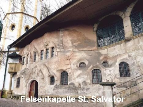
The starting point is Schwäbisch Gmünd, the oldest Staufer town. It is the oldest attested medieval town founding in Württemberg. Many witnesses from this time still characterize the city today. Market square, St. John's Church, Münster, St. Salvator (rock chapel and Stations of the Cross), Prediger (museum) or the Ott-Pausersche factory (silverware museum) are some of the stops that also justify a stay of several days. The State Horticultural Show 2014 also had a lasting impact on the cityscape and the surrounding area. The "heavenly garden" with the "heavenly striker" are impressive witnesses of this. After a visit to the site, a walk through the forest along the "ball track" down to the "Erdenreich" is a good idea.
Attention: The parking space situation in Schwäbisch Gmünd has changed.
Information can be found at: https://www.gmuender-baeder.de/wohnmobilhafen.html
Schießtalstraße 13, 73525, Schwäbisch Gmünd, Deutschland
48° 48' 17" N 9° 48' 49" E
48.8047222 9.8136111
• Head west. Go for 33 m.
• Turn right toward Richard-Bullinger-Straße. Go for 160 m.
• Turn right onto Richard-Bullinger-Straße. Go for 37 m.
• Continue on Schießtalstraße. Go for 318 m.
• Turn right onto Herlikofer Straße (L1075). Go for 499 m.
• Turn left and take ramp onto B29 toward A7/Aalen. Go for 9.3 km.
• Continue on Stuttgarter Straße (B29) toward A7/Aalen. Go for 11.7 km.
• Keep right onto B19 toward Heidenheim/AA-Zentrum/AA-Süd. Go for 316 m.
• Keep right onto B19 toward Heidenheim/Aalen-Süd. Go for 5.1 km.
• Take ramp toward A7/Neresheim/AA-Unterkochen/Ulm/Würzburg. Go for 203 m.
• Turn left onto L1084. Go for 437 m.
• Turn right onto Ebnater Straße (L1084). Go for 4.4 km.
• Continue on B29A. Go for 1.7 km.
• Turn left onto L1076 toward Lauchheim/AA-Waldhausen. Go for 2.4 km.
• Turn right onto Beurener Straße (L1080). Go for 10.2 km.
• Continue toward K3316. Go for 27 m.
• Take the 2nd exit from roundabout onto K3316. Go for 9.5 km.
• Continue on DON6. Go for 1.3 km.
• Turn left onto B466. Go for 2.7 km.
• Take the 3rd exit from roundabout onto Ulmer Straße. Go for 489 m.
• Continue on Bergerstraße. Go for 185 m.
• Turn right onto Neubaugasse. Go for 263 m.
• Continue on Brettermarkt. Go for 53 m.
• Turn left onto Brettermarkt. Go for 36 m.
• Keep right onto Schäfflesmarkt. Go for 126 m.
• Arrive at Schäfflesmarkt. Your destination is on the left.
☍
61,5 km
( 49 min.)
Nördlingen
Nördlingen, Deutschland
48° 51' 2.9" N 10° 29' 22.2" E
48.8508157 10.4894906
• Head northeast on Schäfflesmarkt.
• Turn right onto Rübenmarkt. Go for 41 m.
• Continue on Kohlenmarkt. Go for 66 m.
• Turn left onto Drehergasse. Go for 122 m.
• Turn right onto Deininger Straße. Go for 225 m.
• Continue on Wemdinger Straße. Go for 129 m.
• Take the 2nd exit from roundabout onto Wemdinger Straße toward Wemding. Go for 1.8 km.
• Continue on St2213 toward Wemding. Go for 4.9 km.
• Pass 2 roundabouts and continue on Hauptstraße (St2213). Go for 9.6 km.
• Continue on Bahnhofstraße (St2214). Go for 1.7 km.
• Turn right onto Monheimer Straße (St2214). Go for 2.5 km.
• Turn left onto DON2. Go for 36 m.
• Continue on DON18. Go for 2.3 km.
• Continue on Wemdinger Straße (DON18). Go for 551 m.
• Continue on Hauptstraße (DON18). Go for 796 m.
• Continue on DON18. Go for 533 m.
• Continue on An der Rohrach (DON18). Go for 186 m.
• Continue on DON18. Go for 1.3 km.
• Turn right onto DON2. Go for 41 m.
• Continue on Ottinger Straße (DON2). Go for 380 m.
• Continue on Rehauer Straße (DON2). Go for 277 m.
• Continue on DON2. Go for 886 m.
• Continue on Weilheimer Straße (DON2). Go for 224 m.
• Continue on Abtstraße (DON2). Go for 252 m.
• Continue on Monheimer Straße (DON2). Go for 217 m.
• Continue on DON2. Go for 825 m.
• Turn left onto B2. Go for 8.7 km.
• Turn left onto Heusteig (St2230) toward Treuchtlingen. Go for 1.6 km.
• Turn right onto St2217. Go for 147 m.
• Continue on Augsburger Straße (St2230). Go for 839 m.
• Turn right onto Luitpoldstraße (St2216). Go for 66 m.
• Turn left onto Bahnhofstraße. Go for 430 m.
• Continue on Elkan-Naumburg-Straße. Go for 50 m.
• Arrive at Elkan-Naumburg-Straße. Your destination is on the left.
☍
41,6 km
( 37 min.)
Treuchtlingen
91757 Treuchtlingen, Deutschland
48° 57' 34.3" N 10° 54' 34.7" E
48.9595158 10.9096442
• Head toward Bahnhofstraße on Elkan-Naumburg-Straße. Go for 50 m.
• Continue on Bahnhofstraße. Go for 430 m.
• Turn right onto Hauptstraße (St2216). Go for 66 m.
• Turn left onto Luitpoldstraße (St2230). Go for 839 m.
• Continue on St2217. Go for 147 m.
• Turn left onto An der Heusteige (St2230). Go for 7.3 km.
• Take the 1st exit from roundabout onto St2230. Go for 3.3 km.
• Turn left onto Veitskirch. Go for 25 m.
• Continue on Am Birkenhain. Go for 256 m.
• Continue on Bieswanger Weg. Go for 76 m.
• Turn slightly right onto Bieswanger Weg. Go for 11 m.
• Arrive at Bieswanger Weg. Your destination is on the right.
☍
12,6 km
( 12 min.)
Solnhofen
91807 Solnhofen, Deutschland
48° 53' 49.9" N 10° 59' 49.1" E
48.8971905 10.9969653
• Head northeast on Bieswanger Weg.
• Turn slightly right onto Industriestraße. Go for 294 m.
• Turn slightly right onto Hochholzer Weg. Go for 277 m.
• Turn sharp left onto Eichstätter Straße (St2230). Go for 3.0 km.
• Turn left onto EI16. Go for 1.7 km.
• Continue on Esslinger Straße (EI16). Go for 257 m.
• Continue on Dorfanger (EI16). Go for 400 m.
• Continue on Schernfelder Straße (EI16). Go for 418 m.
• Continue on EI16. Go for 2.5 km.
• Take the 2nd exit from roundabout onto St2047. Go for 1.6 km.
• Take the 2nd exit from roundabout onto St2047. Go for 2.9 km.
• Take the 2nd exit from roundabout onto EI49 toward Kinding/Preith/Wintershof. Go for 4.0 km.
• Take the 1st exit from roundabout onto Lüften (St2225) toward Kinding/Eichstätt. Go for 1.3 km.
• Turn right onto Jura-Hochstraße (St2225). Go for 2.6 km.
• Continue on Pirkheimerstraße (St2230) toward A9/München/Ingolstadt/Weißenburg/Dollnstein/Altmühltal. Go for 287 m.
• Arrive at Pirkheimerstraße (St2230).
☍
21,5 km
( 19 min.)
Eichstätt - Stellplatz an der Altmühl
In Eichstätt it is worth taking a walk through the city before continuing on the route.
Schottenau, 85072, Eichstätt, Deutschland
48° 53' 4" N 11° 11' 51" E
48.8844444 11.1975000
• Head toward Industriestraße on Pirkheimerstraße (St2230). Go for 261 m.
• Take the 3rd exit from roundabout onto Pirkheimerstraße (St2230) toward Nürnberg/A9/Kinding/Kipfenberg/Altmühltal. Go for 652 m.
• Continue on Spindeltal (St2225) toward A9/Nürnberg/Kinding/Beilngries/Thalmassing/Titting. Go for 2.6 km.
• Continue on EI21 toward Nürnberg/Kinding/Beilngries. Go for 7.0 km.
• Take the 2nd exit from roundabout onto EI21 toward München/Nürnberg/Beilngries/Kinding. Go for 7.3 km.
• Continue on St2228. Go for 3.3 km.
• Turn left and take ramp onto A9 toward Berlin/Nürnberg. Go for 21.7 km.
• Take exit 56 toward Hilpoltstein/Neumarkt i.d.OPf./Freystadt. Go for 325 m.
• Turn right onto St2238 toward Neumarkt/Freystadt/Berching/Sindersdorf. Go for 2.1 km.
• Turn left onto Meckenhausen F (RH28). Go for 727 m.
• Continue on RH28. Go for 1.3 km.
• Continue on Pierheim (RH28). Go for 283 m.
• Turn right onto Pierheim (RH28). Go for 315 m.
• Continue on RH28. Go for 1.9 km.
• Turn left onto St2220. Go for 5.3 km.
• Continue on Altstadtring (St2225). Go for 65 m.
• Turn left onto Talstraße. Go for 134 m.
• Turn sharp left onto Sankt-Georgen-Weg. Go for 14 m.
• Arrive at Sankt-Georgen-Weg. Your destination is on the right.
☍
55,3 km
( 39 min.)
Day
Hilpoltstein
91161 Hilpoltstein, Deutschland
49° 11' 20.8" N 11° 11' 18.9" E
49.1891243 11.1885756
• Head toward Talstraße on Sankt-Georgen-Weg. Go for 14 m.
• Turn sharp right onto Talstraße. Go for 134 m.
• Turn right onto Altstadtring (St2225). Go for 172 m.
• Turn left onto Allersberger Straße (St2225). Go for 7.2 km.
• Take the 1st exit from roundabout onto St2237 toward Nürnberg/A9/Freystadt/Allersberg. Go for 439 m.
• Turn left and take ramp onto A9. Go for 29.7 km.
• Take exit 50 toward Rückersdorf/Röthenbach a.d. Peg. Go for 410 m.
• Turn left onto B14 toward Rückersdorf/Röthenbach a.d. Peg./Gewerbegebiet Lauf-Süd. Go for 1.6 km.
• Take ramp toward Lauf a.d. Pegnitz/Eckental. Go for 188 m.
• Turn left onto St2240. Go for 611 m.
• Continue on Nürnberger Straße. Go for 534 m.
• Continue on Friedensplatz. Go for 23 m.
• Turn right onto Glockengießerstraße. Go for 51 m.
• Turn right. Go for 10 m.
• Arrive at your destination.
☍
41,0 km
( 26 min.)
Lauf an der Pegnitz
91207 Lauf an der Pegnitz, Deutschland
49° 30' 39.8" N 11° 16' 40.9" E
49.5110483 11.2780245
• Head toward Glockengießerstraße. Go for 10 m.
• Turn left onto Glockengießerstraße. Go for 51 m.
• Turn left onto Friedensplatz. Go for 23 m.
• Continue on Nürnberger Straße. Go for 1.1 km.
• Take ramp onto B14. Go for 5.7 km.
• Continue on Norisstraße (B14). Go for 1.4 km.
• Turn left and take ramp onto A3 toward Würzburg. Go for 16.2 km.
• Take the exit toward Suhl/Bamberg/Schweinfurt/Erlangen onto A73 (Frankenschnellweg). Go for 17.0 km.
• Take exit 28 toward Ebermannstadt. Go for 632 m.
• Continue on Willy-Brandt-Allee (B470) toward Ebermannstadt/Stadtmitte/Klinikum. Go for 2.2 km.
• Turn right onto Bayreuther Straße (B470). Go for 151 m.
• Continue on Hainbrunnenstraße. Go for 38 m.
• Turn left onto Hainstraße. Go for 228 m.
• Arrive at Hainstraße. Your destination is on the right.
☍
44,8 km
( 32 min.)
Forchheim
91301 Forchheim, Deutschland
49° 43' 16.7" N 11° 4' 11.6" E
49.7213064 11.0698834
• Head north on Hainstraße. Go for 149 m.
• Turn right onto Neuenbergstraße. Go for 23 m.
• Turn left onto Hans-Sachs-Straße. Go for 607 m.
• Turn left onto Untere Kellerstraße (FOs17). Go for 576 m.
• Turn right onto Adenauerallee (St2244). Go for 270 m.
• Turn right onto Bamberger Straße (St2244). Go for 1.2 km.
• Take ramp onto A73. Go for 30.7 km.
• Take exit 19 toward Breitengüßbach-Mitte/Ebern/Baunach. Go for 274 m.
• Turn left onto B279 toward Fulda/Bad Neustadt a.d. Saale/Ebern/Baunach. Go for 3.0 km.
• Turn right onto Überkumstraße (BA39). Go for 77 m.
• Continue on Bahnhofstraße (BA39). Go for 236 m.
• Turn right onto Bahnhofstraße. Go for 34 m.
• Turn slightly right onto Bahnhofstraße. Go for 26 m.
• Turn slightly right onto Bahnhofstraße. Go for 89 m.
• Arrive at Bahnhofstraße. Your destination is on the left.
☍
37,2 km
( 25 min.)
Baunach - Stellplatz am Altstadtparkplatz
Bahnhofstraße, 96148, Baunach, Deutschland
49° 59' 16" N 10° 51' 14" E
49.9877778 10.8538889
• Head north on Bahnhofstraße. Go for 149 m.
• Turn left onto Bahnhofstraße (BA39). Go for 236 m.
• Continue on Überkumstraße (BA39). Go for 77 m.
• Turn left onto Burgstraße (B279) toward Bamberg/Breitengüßbach. Go for 267 m.
• Turn right onto Würzburger Straße (St2277) toward Haßfurt/Ebelsbach/Appendorf. Go for 14.1 km.
• Turn right onto Georg-Schäfer-Straße (St2274). Go for 112 m.
• Turn left onto Zum Nußacker. Go for 319 m.
• Turn right onto Untere Heuernte. Go for 118 m.
• Arrive at Untere Heuernte. Your destination is on the right.
☍
15,4 km
( 14 min.)
Day
Ebelsbach, Deutschland
97500 Ebelsbach, Deutschland
49° 59' 12.3" N 10° 40' 25" E
49.9867381 10.6736086
• Head toward Schustersteige on Untere Heuernte. Go for 121 m.
• Turn right onto Schustersteige. Go for 230 m.
• Turn right onto Georg-Schäfer-Straße (St2274). Go for 841 m.
• Take the 3rd exit from roundabout onto St2447. Go for 724 m.
• Take the 3rd exit from roundabout onto A70 toward Schweinfurt. Go for 18.5 km.
• Take exit 10 toward Haßfurt-West/Königsberg/Donnersdorf/Theres. Go for 305 m.
• Turn right onto St2426 toward Gerolzhofen/Donnersdorf. Go for 1.6 km.
• Turn right onto St2275. Go for 2.9 km.
• Turn right onto Hauptstraße (St2275). Go for 2.9 km.
• Pass 3 roundabouts and continue on Rügshöfer Straße (St2275). Go for 6.9 km.
• Turn right and take ramp onto B286. Go for 7.6 km.
• Take ramp toward Bamberg/Würzburg/Dettelbach. Go for 238 m.
• Turn right onto Neuses am Sand (B22). Go for 11.2 km.
• Take the 2nd exit from roundabout onto B22 toward Kitzingen/Würzburg/Dettelbach. Go for 132 m.
• Turn right and take ramp onto B22 toward Kitzingen/Hörblach. Go for 2.3 km.
• Continue on St2271. Go for 14.4 km.
• Arrive at St2271. Your destination is on the left.
☍
70,8 km
( 52 min.)
Marktbreit - Stellplatz an der Badebucht
Marktstefter Straße 1, 97340, Marktbreit/Main, Deutschland
49° 40' 19" N 10° 9' 1" E
49.6719444 10.1502778
• Head southwest on St2271. Go for 1.3 km.
• Take the 1st exit from roundabout onto St2271. Go for 2.3 km.
• Take ramp onto A7. Go for 17.9 km.
• Take exit 106 toward Creglingen. Go for 270 m.
• Take the 1st exit from roundabout onto Bei der Landwehrstraße (St2419) toward Creglingen/Langensteinach/Gewerbegebiet Landwehrstraße. Go for 5.7 km.
• Continue on Oberscheckenbach (St2419) toward Rothenburg o.d.T./Reichelshofen. Go for 10.2 km.
• Arrive at Würzburger Straße (St2419). Your destination is on the left.
☍
37,6 km
( 24 min.)
Day
Rothenburg ob der Tauber - Stellplatz P2/P3
Mandatory city tour, Christmas village Käthe Wohlfahrt, snowballs
Rothenburg ob der Tauber, Deutschland
49° 22' 48.7" N 10° 11' 12.3" E
49.3801834 10.1867388
• Head southeast on Würzburger Straße (St2419). Go for 463 m.
• Turn right onto Bahnhofstraße (St2419). Go for 354 m.
• Continue on Ansbacher Straße (St2250) toward A7/Würzburg/Ulm/Ansbach/Colmberg/Krankenhaus. Go for 907 m.
• Take the 2nd exit from roundabout onto St2250. Go for 753 m.
• Turn left and take ramp onto A7 toward Ulm. Go for 20.7 km.
• Take exit 110 toward Heilbronn onto A6. Go for 12.9 km.
• Take exit 46 toward Crailsheim/Satteldorf/Blaufelden/Rot am See. Go for 374 m.
• Turn left onto B290 toward Crailsheim/Satteldorf. Go for 3.7 km.
• Turn right onto Nord-West-Umgehung toward Schwäbisch Hall/Crailsheim-West. Go for 3.1 km.
• Take the 2nd exit from roundabout onto K2641. Go for 984 m.
• Pass 3 roundabouts and continue on K2641. Go for 3.0 km.
• Turn right onto Onolzheimer Hauptstraße (L1066). Go for 5.8 km.
• Turn left onto Gaildorfer Straße (L1066). Go for 1.1 km.
• Turn left onto K2637 toward Fronrot/Vorderuhlberg. Go for 1.4 km.
• Turn right onto K2637. Go for 372 m.
• Continue on Schäfer (K2637). Go for 148 m.
• Continue on K2637. Go for 362 m.
• Continue on Hinteruhlberg (K2637). Go for 887 m.
• Continue on K2637. Go for 1.3 km.
• Continue on Lindenstraße (K2637). Go for 420 m.
• Continue on Turmstraße (K2637). Go for 318 m.
• Continue on K2637. Go for 142 m.
• Continue on Turmstraße (K2637). Go for 106 m.
• Turn right onto Salzstraße (L1060). Go for 417 m.
• Arrive at L1060.
☍
60,0 km
( 45 min.)
Day
Fronrot
L1060, 74424 Bühlertann, Deutschland
49° 2' 0.8" N 9° 56' 56.9" E
49.0335672 9.9491459
• Head toward Kirchweihäcker on L1060. Go for 409 m.
• Turn right onto Tollbergstraße. Go for 152 m.
• Continue on Tollbergstraße. Go for 1.8 km.
• Continue on Blashof. Go for 176 m.
• Continue on Halden. Go for 132 m.
• Turn left onto Halden. Go for 549 m.
• Continue on Kreidelhaus. Go for 250 m.
• Turn right onto K2626. Go for 1.1 km.
• Turn slightly right onto Frühmeßhalde (K2626). Go for 287 m.
• Turn left onto Kottspieler Straße (L1072). Go for 3.3 km.
• Turn right onto Klingenbachstraße (K2632). Go for 1.2 km.
• Continue on K2632. Go for 571 m.
• Continue on Gantenwald (Bühlerzell) (K2632). Go for 336 m.
• Continue on Gantenwald (Geifertshofen) (K2632). Go for 184 m.
• Continue on K2632. Go for 495 m.
• Continue on Immersberg (K2632). Go for 543 m.
• Continue on K2632. Go for 1.3 km.
• Continue on Kohlwald (K2632). Go for 38 m.
• Continue on K2632. Go for 363 m.
• Continue on Vogelhöfle (K2632). Go for 155 m.
• Continue on K2632. Go for 115 m.
• Turn right onto K2633. Go for 186 m.
• Continue on Weißenhaus (K2633). Go for 315 m.
• Continue on K2633. Go for 493 m.
• Continue on Herrenfeld (K2633). Go for 338 m.
• Continue on K2633. Go for 31 m.
• Continue on Steigenhaus (K2633). Go for 168 m.
• Continue on Schloßschmiedelfeld (K2633). Go for 79 m.
• Turn left onto K2633. Go for 965 m.
• Continue on Am Bärenberg (K2633). Go for 546 m.
• Continue on Eisbachstraße (K2633). Go for 91 m.
• Turn right onto Hauptstraße (B19). Go for 343 m.
• Turn right onto Eichelbergstraße. Go for 109 m.
• Turn slightly right onto Am Wäldle. Go for 101 m.
• Arrive at Am Wäldle. Your destination is on the right.
☍
17,1 km
( 24 min.)
Sulzbach-Laufen
74429 Sulzbach-Laufen, Deutschland
48° 57' 54.4" N 9° 50' 38.4" E
48.9651235 9.8439986
• Head toward Eichelbergstraße on Am Wäldle. Go for 101 m.
• Turn slightly left onto Eichelbergstraße. Go for 109 m.
• Turn left onto Hauptstraße (B19). Go for 975 m.
• Turn right onto Nestelbergstraße (K2635) toward Gschwend/Rotenhar/Nestelberg/Stephan-Keck-Halle. Go for 218 m.
• Continue on Gesöde (K2635). Go for 651 m.
• Continue on Bayerhöfle (K2635). Go for 836 m.
• Continue on Nestelberg (K2635). Go for 158 m.
• Continue on K2635. Go for 2.4 km.
• Continue on K3248. Go for 221 m.
• Continue on Steinhöfle (K3248). Go for 189 m.
• Continue on K3248. Go for 1.2 km.
• Continue on Hohentannenstraße (K3248). Go for 135 m.
• Continue on K3248. Go for 38 m.
• Turn right onto Hohentannenstraße (L1080). Go for 2.8 km.
• Take the 2nd exit from roundabout onto Frickenhofer Straße (L1080). Go for 552 m.
• Turn left onto Gmünder Straße (B298). Go for 18.6 km.
• Turn right onto Pfitzerstraße (B298). Go for 147 m.
• Take the 2nd exit from roundabout onto Baldungstraße (L1075) toward Aalen/B29/Zentrum. Go for 167 m.
• Pass 2 roundabouts and continue on Baldungstraße. Go for 294 m.
• Continue on Oberbettringer Straße. Go for 116 m.
• Turn left onto Rauchbeinstraße. Go for 111 m.
• Arrive at Rauchbeinstraße.
☍
29,9 km
( 30 min.)
Schwäbisch Gmünd
Schwäbisch Gmünd, Deutschland
48° 47' 57.8" N 9° 48' 16.5" E
48.7994019 9.8045704