The only goal of this trip was to pick up Tanja again after 6 weeks and almost 1,000 km (!) of the Way of St. James.
A round conclusion at the end of the "camino" in Finisterre, a trip to Andalusia to visit relatives but also to finally do the cathedral in Cordoba live, a bit of a spiritual conclusion via Fatima and the other St. Jean Pied de Port starting points on the Way of St. James and Puy en Velais. This time I also had the motorcycle piggyback with me to head for the longer distances as day trips. That went quite well, but: the rural areas in Spain and especially Portugal are challenging by car, adventurous with a motorhome and with a motorcycle trailer behind the motorhome "a nightmare"! I don't do it anymore...
Day
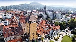
Reutlingen, Deutschland
48° 29' 28.5" N 9° 12' 16.7" E
48.4912389 9.2046411
• Head toward Konrad-Adenauer-Straße on Eberhardstraße. Go for 10 m.
• Turn left onto Eberhardstraße. Go for 260 m.
• Make a U-Turn onto Eberhardstraße. Go for 240 m.
• Turn right onto Konrad-Adenauer-Straße (B464) toward Tübingen/B28/RT-Betzingen/Rt.-Ohmenhausen/Gewerbegebiet-West. Go for 879 m.
• Keep right onto Konrad-Adenauer-Straße (B464) toward Tübingen/Rt.-Ohmenhausen/RT-Betzingen/Gewerbegebiet-West. Go for 181 m.
• Take ramp onto B28 toward Tübingen/Rt.-Ohmenhausen/RT-Betzingen/Gewerbegebiet-West. Go for 11.6 km.
• Take ramp toward Rottenburg/Paul Horn-Arena. Go for 181 m.
• Turn right onto Europastraße. Go for 18.5 km.
• Take ramp onto A81 toward Singen. Go for 66.7 km.
• Take exit 37 toward Freiburg/Donaueschingen onto A864. Go for 6.1 km.
• Take the exit onto B27/B33. Go for 8.7 km.
• Take ramp onto B31 toward Freiburg/Titisee-Neustadt. Go for 64.8 km.
• Take ramp onto A5 toward Basel. Go for 35.6 km.
• Take exit 66 toward Lyon/Mulhouse/Flughafen Euro onto A5. Go for 611 m.
• Continue on A36 (La Comtoise). Go for 13.5 km.
• Keep left onto A36 (La Comtoise) toward Paris/Lyon/Guebwiller. Go for 223 km.
• Take the exit onto A31. Go for 6.1 km.
• Continue on A6 (Autoroute du Soleil). Go for 31.2 km.
• Take exit 26 toward Lons le Saunier/Montceau les M./Le Creusot. Go for 1.2 km.
• Take the 2nd exit from roundabout onto Route Express Chalon Montceau (N80) toward Moulins/Montceau les M./Le Creusot/Cluny. Go for 746 m.
• Take the 2nd exit from Giratoire de Cortelin roundabout onto Route Express Chalon Montceau (N80) toward Moulins/Montceau les M./Le Creusot. Go for 26.6 km.
• Take the 3rd exit from Rond-Point Jeanne Rose roundabout onto N70 toward Montchanin/Montceau les M./Moulins/Montchanin-Centre. Go for 44.0 km.
• Continue on N79. Go for 844 m.
• Keep left onto N79 toward Moulins/Nevers/Roanne/Vichy/Digoin/Paray le M.-Sud. Go for 9.0 km.
• Keep left onto A79 toward Montluçon/Nevers/Vichy/Moulins/Digoin-Ouest. Go for 91.3 km.
• Take the exit toward Clermont-Fd onto A71. Go for 48.1 km.
• Take the exit toward Bordeaux/Limoges onto A89. Go for 161 km.
• Take the left exit toward E70/Toulouse/Bordeaux/Périgueux/Brive la G. onto A20 (L'Occitane). Go for 16.7 km.
• Take the exit toward Bordeaux/Périgueux/Sarlat onto A89 (Viaduc du Maumont). Go for 168 km.
• Continue on N89. Go for 17.8 km.
• Keep left onto N89 toward Arcachon/Bayonne/Toulouse/Bordeaux-St Jean/Z.I. Artigues. Go for 217 m.
• Take ramp onto Rocade de Bordeaux (N230) toward Arcachon/Bayonne/Toulouse/Bordeaux-Centre/Bordeaux-St Jean/Z.I. Artigues. Go for 17.7 km.
• Take exit 15 toward Saint Sébastien/Bayonne/Mont de Marsan/Bassin d'Arcachon onto A63. Go for 206 km.
• Continue on AP-8 (Autopista del Cantábrico). Go for 12.2 km.
• Take the exit toward Bilbao/Vitoria-Gasteiz/Burgos/Hernani/A-15/Iruña/Pamplona onto AP-1/AP-8. Go for 6.9 km.
• Take exit 19 toward Hernani/Iruña/Pamplona onto A-15 (Autovía del Urumea). Go for 10.6 km.
• Take the exit onto N-1. Go for 2.7 km.
• Keep right onto A-15 (Agaraitz auzoa) toward Irurtzun/Iruña/Pamplona. Go for 44.4 km.
• Continue on AP-15 (Autopista de Navarra). Go for 15.5 km.
• Continue on A-15 (Ronda Oeste). Go for 13.2 km.
• Continue on AP-15 (Autopista de Navarra). Go for 807 m.
• Take exit 82 toward Sangüesa/Huesca onto A-21. Go for 33.3 km.
• Take exit 39 toward Liédena/Sangüesa. Go for 352 m.
• Take the 2nd exit from roundabout onto NA-2420 toward Liédena/Sangüesa. Go for 2.1 km.
• Take the 2nd exit from roundabout onto NA-127 toward Sangüesa/Sos del Rey Católico. Go for 2.0 km.
• Take the 1st exit from roundabout onto NA-127. Go for 707 m.
• Take the 3rd exit from roundabout onto NA-127. Go for 1.9 km.
• Take the 1st exit from roundabout onto NA-127. Go for 918 m.
• Take the 1st exit from roundabout. Go for 46 m.
• Continue on Carretera de Sos del Rey Católico (NA-8603). Go for 296 m.
• Turn left onto Calle de la Magdalena (NA-8603). Go for 250 m.
• Take the 1st exit from roundabout onto Calle Sancho Garcés. Go for 105 m.
• Turn slightly right onto Calle Antonio Eslava. Go for 14 m.
• Turn left onto Plaza Portal de Peñalta. Go for 43 m.
• Turn left onto Travesía Balate. Go for 24 m.
• Turn right onto Calle Estudio. Go for 70 m.
• Arrive at Calle Estudio. Your destination is on the left.
☍
1,446,4 km
(13 hrs. 10 min.)
Sangüesa, Spanien
Small village on the pilgrimage route - here I only had to collect a few things from Tanja. In the village there are some hostels and small shops. If you drive through this landscape from Pamplona you will see some pilgrims and get a first impression of the Camino - beautiful, almost untouched nature, always the Pyrenees in view and vast emptiness...
I spent the night at a rest stop on the Autobahn: safe, quiet and a cup of coffee in the morning...
31400 Sangüesa, Navarre, Spanien
42° 34' 28" N 1° 16' 59.1" W
42.5744349 -1.2830851
• Head toward Calle Jenaro Vallejos on Calle Estudio. Go for 52 m.
• Turn right onto Calle Jenaro Vallejos. Go for 56 m.
• Continue on Calle Jenaro Vallejos. Go for 96 m.
• Turn right onto Calle Mayor. Go for 29 m.
• Continue on Plaza de los Fueros. Go for 64 m.
• Continue on Calle San Francisco Javier (NA-5410). Go for 180 m.
• Continue on NA-5410. Go for 294 m.
• Take the 1st exit from roundabout. Go for 65 m.
• Take the 1st exit from roundabout onto NA-127. Go for 1.8 km.
• Pass 2 roundabouts and continue on NA-127. Go for 2.6 km.
• Take the 2nd exit from roundabout onto NA-2420 toward A-21/Pamplona/Huesca/Nardués-Aldunate. Go for 2.0 km.
• Take the 2nd exit from roundabout. Go for 144 m.
• Take the 2nd exit from roundabout onto A-21 (Autovía del Pirineo) toward Pamplona. Go for 32.8 km.
• Take the exit toward Noáin/PA-31/Aeropuerto/N-121/Tudela/Zaragoza/Madrid onto AP-15 (Autopista de Navarra). Go for 1.6 km.
• Continue on A-15 (Iruñako autobidea) toward Francia/Logroño/Vitoria-Gasteiz/Donostia/San Sebastián. Go for 13.3 km.
• Continue on AP-15 (Autopista de Navarra) toward Vitoria-Gasteiz/Donostia-San Sebastián/Francia-Frantzia. Go for 15.6 km.
• Take exit 112 toward Altsasu/Alsasua/Vitoria/Gasteiz onto A-10 (Autovía de la Barranca). Go for 29.6 km.
• Take the exit onto A-1. Go for 69.5 km.
• Take exit 328 toward Burgos/Logroño/AP-68/Bilbao onto AP-1 (Autovía del Norte). Go for 83.3 km.
• Continue on A-1 (Autovía del Norte) toward Madrid/A-62/Valladolid/Portugal. Go for 7.1 km.
• Keep right onto BU-30 (Nudo de Landa) toward Palencia/Valladolid/A-62/León/A-231. Go for 4.2 km.
• Take the exit toward Burgos (Oeste)/N-120/N-120/León/A-231/Santander/A-73/Polígono Industrial de Villalonquéjar onto BU-30. Go for 4.7 km.
• Keep left onto BU-30 toward León/A-231/Burgos (Oeste)/N-120/Villalbilla de Burgos/Tardajos/Polígono Industrial de Villalonquéjar. Go for 1.4 km.
• Continue on A-231 toward Villanueva de Argaño/León. Go for 158 km.
• Take the exit toward Oviedo onto A-66 (Autovía Ruta de la Plata). Go for 8.7 km.
• Take exit 143 toward Astorga onto AP-71. Go for 38.6 km.
• Take exit 37 toward A Coruña onto A-6 (Autovía del Noroeste). Go for 271 km.
• Take ramp onto AG-55 (Autovía da Costa da Morte) toward Carballo. Go for 52.3 km.
• Continue on Vía Alta C. Carballo-Berdoias (VG-1.5). Go for 2.1 km.
• Take the 2nd exit from roundabout onto Santa Irena (AC-552) toward Vimianzo. Go for 28.5 km.
• Take the 2nd exit from roundabout onto VG-1.4. Go for 4.9 km.
• Take the 2nd exit from roundabout onto AC-445. Go for 229 m.
• Continue on Estorde (AC-445). Go for 209 m.
• Arrive at Estorde (AC-445). Your destination is on the left.
☍
834,7 km
(7 hrs. 15 min.)
Day
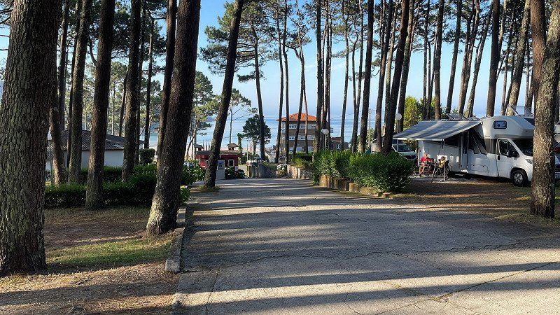
Camping Ruta De Finisterre, Lugar Playa Estorde, Cee, Spanien
Super campsite: across the street is the beach, a few restaurants and from the site in no time to Finisterre (we by motorbike) or to nearby destinations. Place has large footprints and everything you need. Clean and good sanitary facilities and cheap. I didn't have to reserve in advance - apparently the crowds of visitors here don't start until the middle/end of July.
Lugar Playa Estorde, 216, 15270 Cee, A Coruña, Spanien
42° 56' 39.9" N 9° 13' 13" W
42.9444097 -9.2202757
• Head east on Estorde (AC-445). Go for 530 m.
• Turn sharp left onto Estorde. Go for 21 m.
• Turn left onto Estorde. Go for 46 m.
• Turn right onto Estorde. Go for 60 m.
• Turn right onto Estorde (AC-445). Go for 739 m.
• Continue on AC-445. Go for 137 m.
• Take the 2nd exit from roundabout onto Rúa da Coruña (AC-445). Go for 1.2 km.
• Continue on AC-445. Go for 196 m.
• Continue on Sardiñeiro de Abaixo (AC-445). Go for 50 m.
• Continue on AC-445. Go for 17 m.
• Continue on Sardiñeiro de Abaixo (AC-445). Go for 211 m.
• Continue on AC-445. Go for 2.0 km.
• Continue on Calcova (AC-445). Go for 222 m.
• Continue on AC-445. Go for 120 m.
• Continue on Calcova (AC-445). Go for 308 m.
• Continue on AC-445. Go for 53 m.
• Continue on Calcova (AC-445). Go for 38 m.
• Continue on Avenida da Anchoa (AC-445). Go for 1.1 km.
• Continue on Avenida de Galicia (AC-445). Go for 496 m.
• Continue on Rúa Cabello (AC-445). Go for 443 m.
• Continue on Avenida da Coruña (AC-445). Go for 300 m.
• Turn right onto Travesía Cabo Fisterra (AC-445). Go for 38 m.
• Continue on Rúa Cabo Fisterra (AC-445). Go for 117 m.
• Continue on Rúa Alcalde Fernández (AC-445). Go for 201 m.
• Arrive at Rúa Alcalde Fernández (AC-445). Your destination is on the right.
☍
8,7 km
( 10 min.)
Finisterre, Spanien
Fisterra, Provinz A Coruña, Spanien
42° 54' 28.1" N 9° 15' 54.1" W
42.9078005 -9.2650315
• Head toward Camiño da Barcia on Rúa Alcalde Fernández (AC-445). Go for 426 m.
• Continue on Rúa Alcalde Fernández (AC-445). Go for 24 m.
• Continue on Rúa Manuel López Garabal (AC-445). Go for 422 m.
• Continue on Fisterra (AC-445). Go for 512 m.
• Continue on A Insua (AC-445). Go for 1.4 km.
• Continue on AC-445. Go for 196 m.
• Continue on O Cabo (AC-445). Go for 272 m.
• Continue on O Cabo. Go for 27 m.
• Arrive at O Cabo. Your destination is on the right.
☍
3,2 km
( 7 min.)
Day
Faro de Finisterre, Cabo Fisterra, Fisterra, Spanien
Cabo Fisterra, s/n, 15155 Fisterra, A Coruña, Spanien
42° 52' 56.6" N 9° 16' 18.8" W
42.8823917 -9.2718758
• Head north on O Cabo. Go for 27 m.
• Continue on O Cabo (AC-445). Go for 272 m.
• Continue on AC-445. Go for 196 m.
• Continue on A Insua (AC-445). Go for 1.4 km.
• Keep right onto Fisterra (AC-445). Go for 512 m.
• Continue on Rúa Manuel López Garabal (AC-445). Go for 300 m.
• Keep left onto Rúa Manuel López Garabal (AC-445). Go for 122 m.
• Continue on Rúa Alcalde Fernández (AC-445). Go for 651 m.
• Continue on Rúa Cabo Fisterra (AC-445). Go for 117 m.
• Continue on Travesía Cabo Fisterra (AC-445). Go for 38 m.
• Turn left onto Avenida da Coruña (AC-445). Go for 300 m.
• Continue on Rúa Cabello (AC-445). Go for 443 m.
• Continue on Avenida de Galicia (AC-445). Go for 496 m.
• Continue on Avenida da Anchoa (AC-445). Go for 1.1 km.
• Continue on Calcova (AC-445). Go for 38 m.
• Keep right onto AC-445. Go for 53 m.
• Continue on Calcova (AC-445). Go for 308 m.
• Continue on AC-445. Go for 120 m.
• Continue on Calcova (AC-445). Go for 222 m.
• Continue on AC-445. Go for 2.0 km.
• Continue on Sardiñeiro de Abaixo (AC-445). Go for 211 m.
• Continue on AC-445. Go for 17 m.
• Continue on Sardiñeiro de Abaixo (AC-445). Go for 50 m.
• Continue on AC-445. Go for 196 m.
• Continue on Rúa da Coruña (AC-445). Go for 1.2 km.
• Take the 2nd exit from roundabout onto VG-1.4. Go for 4.9 km.
• Take the 1st exit from roundabout onto Xallas (AC-552). Go for 625 m.
• Take the 2nd exit from roundabout onto O Vilar de Toba (AC-552). Go for 1.7 km.
• Turn left onto Avenida Fernando Blanco (AC-550). Go for 9.6 km.
• Turn left onto O Ézaro (CP-2308). Go for 722 m.
• Turn right onto Camiño a Central Hidroeléctrica. Go for 309 m.
• Arrive at Camiño a Central Hidroeléctrica.
☍
28,1 km
( 33 min.)
Fervenza do Ézaro, Rio do Barco, Dumbría, Spanien
Rio do Barco, s/n, 15297 Dumbría, A Coruña, Spanien
42° 54' 45.8" N 9° 6' 58.8" W
42.9127276 -9.1163295
• Head toward O Ézaro on Camiño a Central Hidroeléctrica. Go for 309 m.
• Turn sharp right onto O Ézaro (CP-2308). Go for 900 m.
• Continue on CP-2308. Go for 268 m.
• Continue on Santa Uxía (CP-2308). Go for 588 m.
• Continue on CP-2308. Go for 796 m.
• Continue on Estrada Santa Uxía a Fieiro. Go for 1.6 km.
• Continue on O Fieiro. Go for 124 m.
• Continue on Estrada Barrio Fiero. Go for 335 m.
• Continue on O Lugariño. Go for 97 m.
• Continue on Estrada Barrio Fiero. Go for 391 m.
• Continue on Estrada Barrio Noveira. Go for 1.6 km.
• Continue on A Curra. Go for 263 m.
• Continue on Estrada Paxareiras. Go for 6.1 km.
• Turn left onto As Paxareiras. Go for 93 m.
• Turn right onto As Paxareiras. Go for 80 m.
• Turn left onto As Paxareiras (AC-400). Go for 9.0 km.
• Take the 3rd exit from roundabout onto AC-400. Go for 12.1 km.
• Take the 1st exit from roundabout onto AC-546. Go for 439 m.
• Take the 3rd exit from roundabout onto A Pereiriña (AC-546). Go for 12.3 km.
• Pass 3 roundabouts and continue on AC-544. Go for 11.9 km.
• Take the 3rd exit from roundabout onto AG-56 toward Santiago. Go for 8.0 km.
• Take the exit toward Pontevedra onto AP-9 (Autoestrada do Atlántico). Go for 102 km.
• Take the exit toward Tui (sur)/Portugal onto A-55. Go for 4.9 km.
• Continue on A3 (Autoestrada do Minho). Go for 112 km.
• Take the exit onto A20 (CRIP). Go for 12.6 km.
• Continue on A1 (Autoestrada do Norte). Go for 226 km.
• Take exit 6 toward Santarém/A2/A6/A13 onto N114. Go for 7.0 km.
• Take ramp onto IC10 toward Algarve/A2/A6/A13/Évora/Coruche/Almeirim. Go for 1.8 km.
• Continue on IC10. Go for 6.9 km.
• Keep left onto A13 (Autoestrada do Pinhal Interior) toward Salvaterra/Algarve/A2/A6/A10. Go for 78.1 km.
• Continue on Nó da A2-A6-A13 toward Algarve/A2/Alcácer/Espanha/A6/Évora. Go for 1.3 km.
• Continue on A2 (Autoestrada do Sul). Go for 120 km.
• Take exit 12 toward Mértola onto IP2. Go for 9.0 km.
• Take ramp toward Aljustrel/C. Verde/Mértola. Go for 237 m.
• Turn left onto N2. Go for 197 m.
• Take the 2nd exit from roundabout onto N2. Go for 420 m.
• Take the 3rd exit from Avenida General Humberto Delgado roundabout onto Rua das Orquídeas (N123). Go for 220 m.
• Pass 2 roundabouts and continue on N123. Go for 31.0 km.
• Turn right onto N122. Go for 11.0 km.
• Take the 3rd exit from roundabout onto N265. Go for 4.4 km.
• Turn right onto M1153. Go for 10.0 km.
• Turn right onto M514. Go for 4.6 km.
• Continue on HU-6400. Go for 12.0 km.
• Take the 1st exit from roundabout toward Sanlúcar de Guadiana/HU-4402. Go for 173 m.
• Turn right onto Carretera Sanlúcar (HU-4402) toward Pomarao/HU-6400. Go for 89 m.
• Continue on HU-4402. Go for 7.0 km.
• Take the 1st exit from roundabout. Go for 78 m.
• Continue straight ahead. Go for 122 m.
• Turn right toward Calle Juan Ramón Jiménez. Go for 34 m.
• Turn left onto Calle Juan Ramón Jiménez. Go for 129 m.
• Turn right onto Calle Juan Ramón Jiménez. Go for 7 m.
• Turn right onto Calle Montrugato. Go for 27 m.
• Arrive at Calle Montrugato. Your destination is on the right.
☍
831,2 km
(7 hrs. 54 min.)
Day
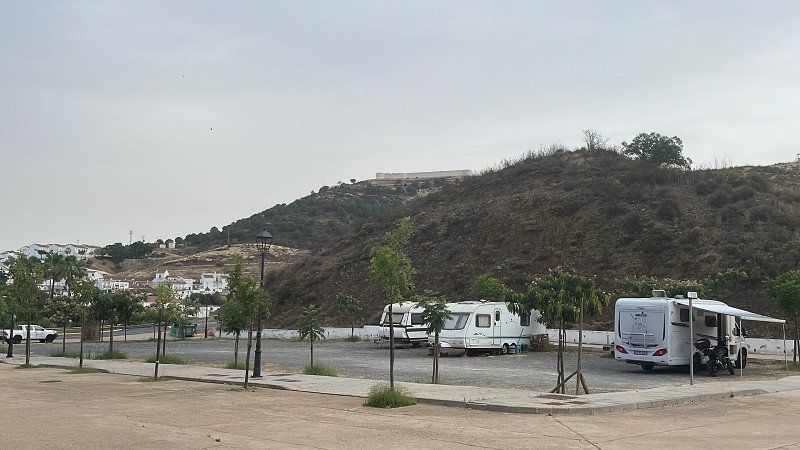
Sanlúcar de Guadiana, Spanien
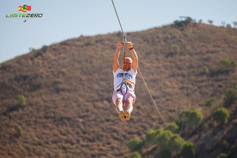
Off to Uncle in Sanlucar - just over 400 inhabitants but almost always something going on. Anyone who has never been there must have seen it: with the "limitezero" zip line over the Rio Guadiana to Portugal, and back by boat. Alcoutim on the Portuguese side opposite is also interesting.
The parking space is really simple...: at least there is water - but: parking space and water are free! If you like it puristic, you can stand here for a while and start hiking or driving from here (but everything is very mountainous here - not for lowland cyclists!)
21595 Sanlúcar de Guadiana, Huelva, Spanien
37° 28' 22.8" N 7° 27' 58.3" W
37.4730074 -7.4661973
• Head toward Trasera Montes Gomez on Calle Montrugato. Go for 10 m.
• Turn right toward Calle Montrugato. Go for 14 m.
• Turn slightly right onto Calle Montrugato. Go for 76 m.
• Turn slightly right onto Calle Montrugato. Go for 34 m.
• Turn right onto Calle Montrugato. Go for 20 m.
• Turn left onto Calle Juan Ramón Jiménez. Go for 33 m.
• Turn right. Go for 34 m.
• Turn left toward HU-4402. Go for 188 m.
• Take the 2nd exit from roundabout onto HU-4402 toward El Grando. Go for 7.1 km.
• Continue on Carretera Sanlúcar (HU-4402). Go for 89 m.
• Turn left toward Grupo Escolar. Go for 162 m.
• Take the 1st exit from roundabout onto Grupo Escolar toward Villanueva de los Castillejos/HU-4402. Go for 167 m.
• Continue on Carretera Villanueva de los Castillejos. Go for 232 m.
• Continue on HU-4402. Go for 13.0 km.
• Turn right toward Puebla de Guzmán/S. Bartolomé de la Torre. Go for 31 m.
• Take the 2nd exit from roundabout onto A-490/A-499 toward Puebla de Guzmán. Go for 785 m.
• Pass 2 roundabouts. Go for 14.4 km.
• Continue on A-495. Go for 16.1 km.
• Turn left onto N-431 toward Gibraleón/H-30/Huelva. Go for 4.2 km.
• Continue on H-30. Go for 608 m.
• Take ramp onto A-49 (Autopista del V Centenario) toward Sevilla. Go for 88.0 km.
• Keep right toward E-803/Mérida/A-66/Aeropuerto/E-5/Córdoba/A-4. Go for 302 m.
• Continue on SE-30. Go for 649 m.
• Continue on A-66. Go for 2.3 km.
• Take the exit toward Isla de la Cartuja/Córdoba/E-5/A-4 onto SE-30 (Ronda Urbana Norte). Go for 3.9 km.
• Take the 3rd exit from Glorieta Olímpica roundabout onto Avenida Juventudes Musicales (SE-30). Go for 876 m.
• Keep left onto Ronda Urbana Norte (SE-30). Go for 3.4 km.
• Take the exit toward E-5/A-4/Aeropuerto/Carmona/Córdoba onto Nudo Gota de Leche. Go for 492 m.
• Continue on A-4 (Nudo Gota de Leche). Go for 126 km.
• Take exit 409B toward Córdoba (Oeste)/Aeropuerto onto CO-32. Go for 5.6 km.
• Take the 1st exit from roundabout onto Avenida del Aeropuerto (N-437) toward Córboba/Córdoba. Go for 821 m.
• Take the 2nd exit from roundabout onto Avenida del Aeropuerto (N-437) toward Centro Ciudad. Go for 2.0 km.
• Turn slightly left onto Glorieta Cruz Roja toward Centro Ciudad. Go for 87 m.
• Take the 1st exit from roundabout onto Glorieta Cruz Roja toward Centro Ciudad. Go for 131 m.
• Continue on Paseo de la Victoria. Go for 554 m.
• Turn slightly right onto Avenida Ronda de los Tejares toward Centro Ciudad/Plaza de Colón. Go for 499 m.
• Turn right onto Calle Caño. Go for 73 m.
• Turn left onto Calle Manuel María de Arjona. Go for 56 m.
• Arrive at Calle Manuel María de Arjona. Your destination is on the left.
☍
292,9 km
(2 hrs. 58 min.)
Day
Sanlucar de Guadiana
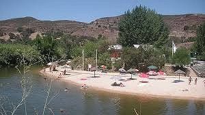
located right on the river.
Here on the river beach you can rent paddle boats and SUPs, go flyboarding, drive a motor boat yourself or take a tour of the Guadiana. Above is a castle ruin and you can also walk a few hiking trails. In Alcoutim there is also a castle and a city beach. Excursions by car/motorcycle: Mertula (P), Minas de Riotinto (E, I think it's great!), to the sea -> Isla Canela or Cristina, Algarve, Huelva,...
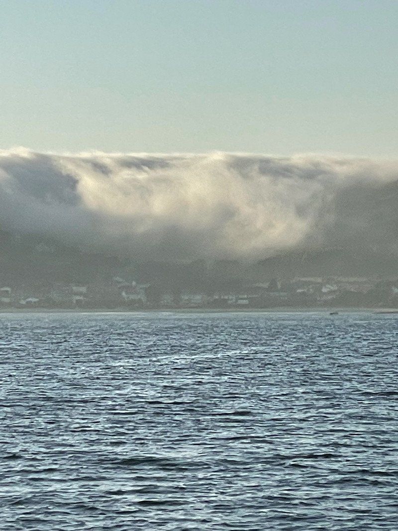
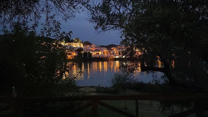
Evening photo is from Spain over to Portugal from the chiringuito right on the river.
Day
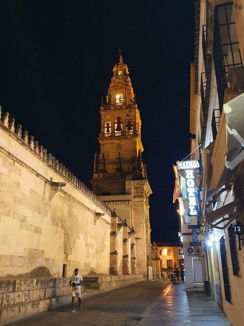
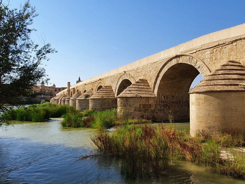
Córdoba, Spanien
Córdoba, Provinz Córdoba, Spanien
37° 53' 17.4" N 4° 46' 45.8" W
37.8881751 -4.7793835
• Head east on Calle Manuel María de Arjona.
• Turn left onto Calle Puerta Osario. Go for 136 m.
• Turn right onto Plaza de Colón. Go for 143 m.
• Keep left onto Plaza de Colón. Go for 320 m.
• Turn right onto Avenida de las Ollerías toward Avda. de las Ollerías/Ronda del Marrubial/Madrid/E-5/N-4. Go for 768 m.
• Turn right onto Glorieta de la Fuensantilla toward Avda. de Barcelona. Go for 35 m.
• Turn right onto Calle Ronda del Marrubial toward Avda. de Barcelona. Go for 295 m.
• Continue on Avenida de Barcelona. Go for 671 m.
• Turn right onto Calle Campo de San Antón toward Estadio Municipal El Arcángel. Go for 376 m.
• Continue on Calle Campo Madre de Dios. Go for 373 m.
• Continue on Ronda de los Mártires. Go for 91 m.
• Continue on Avenida Compositor Rafael Castro. Go for 868 m.
• Take ramp onto A-4 (Autovía Ronda de Córdoba) toward Granada/N-432/Sevilla/Málaga. Go for 132 km.
• Continue on Nudo Gota de Leche toward Centro Ciudad Sevilla/avd. Kansas City/Estación de Santa Justa. Go for 392 m.
• Take the exit toward Ronda Urbana Norte/Sevilla Norte/E-803/Mérida/A-66 onto SE-30 (Nudo Gota de Leche). Go for 4.2 km.
• Take the 2nd exit from Glorieta Olímpica roundabout onto SE-30 (Puente El Alamillo) toward Huelva/E-1/A-49/Mérida/E-803/N-630/Isla de la Cartuja/Estadio Olímpico. Go for 3.7 km.
• Take the exit toward A-49/Huelva/E-5/A-4/Cádiz onto A-66 (Autovía de la Plata). Go for 2.9 km.
• Take exit 17C toward Camas onto A-49 (Autopista del V Centenario). Go for 87.2 km.
• Take exit 87 toward Gibraleón/N-431 onto H-30. Go for 1.1 km.
• Continue on N-431. Go for 4.1 km.
• Keep right toward San Bartolomé/Tharsis. Go for 165 m.
• Continue on A-495. Go for 16.0 km.
• Take ramp toward Villanueva de los Castillejos/A-495. Go for 272 m.
• Take the 3rd exit from roundabout onto A-490 toward Gibraleón/A-495/Villanueva de los Castillejos. Go for 196 m.
• Take the 1st exit from roundabout onto A-490 toward Villanueva de los Castillejos. Go for 14.1 km.
• Take the 3rd exit from roundabout onto A-490/A-499 toward San Silvestre de Guzmán. Go for 827 m.
• Take the 2nd exit from roundabout onto HU-4402 toward El Granado. Go for 13.0 km.
• Continue on Carretera Villanueva de los Castillejos (HU-4402). Go for 232 m.
• Continue on Grupo Escolar. Go for 156 m.
• Take the 2nd exit from roundabout toward Sanlúcar de Guadiana/HU-4402. Go for 186 m.
• Turn right onto Carretera Sanlúcar (HU-4402) toward Pomarao/HU-6400. Go for 89 m.
• Continue on HU-4402. Go for 7.0 km.
• Take the 1st exit from roundabout. Go for 78 m.
• Continue straight ahead. Go for 122 m.
• Turn right toward Calle Juan Ramón Jiménez. Go for 34 m.
• Turn left onto Calle Juan Ramón Jiménez. Go for 129 m.
• Turn right onto Calle Juan Ramón Jiménez. Go for 7 m.
• Turn right onto Calle Montrugato. Go for 27 m.
• Arrive at Calle Montrugato. Your destination is on the right.
☍
292,8 km
(2 hrs. 59 min.)
Day
Sanlúcar de Guadiana, Spanien
21595 Sanlúcar de Guadiana, Huelva, Spanien
37° 28' 22.8" N 7° 27' 58.3" W
37.4730074 -7.4661973
• Head toward Trasera Montes Gomez on Calle Montrugato. Go for 10 m.
• Turn right toward Calle Montrugato. Go for 14 m.
• Turn slightly right onto Calle Montrugato. Go for 76 m.
• Turn slightly right onto Calle Montrugato. Go for 34 m.
• Turn right onto Calle Montrugato. Go for 20 m.
• Turn left onto Calle Juan Ramón Jiménez. Go for 33 m.
• Turn right. Go for 34 m.
• Turn left toward HU-4402. Go for 188 m.
• Take the 2nd exit from roundabout onto HU-4402 toward El Grando. Go for 7.1 km.
• Continue on Carretera Sanlúcar (HU-4402). Go for 89 m.
• Turn left toward HU-6400. Go for 162 m.
• Take the 2nd exit from roundabout onto HU-6400 toward Pomarao/Portugal. Go for 12.0 km.
• Continue on M514. Go for 4.6 km.
• Turn left onto M1153. Go for 10.0 km.
• Turn left onto N265. Go for 4.2 km.
• Take the 2nd exit from roundabout onto N122. Go for 11.1 km.
• Turn left onto N123. Go for 30.6 km.
• Pass 2 roundabouts and continue on Rua das Orquídeas (N123). Go for 530 m.
• Take the 2nd exit from Avenida General Humberto Delgado roundabout onto N2. Go for 411 m.
• Take the 2nd exit from roundabout onto N2. Go for 386 m.
• Turn left and take ramp onto IP2. Go for 7.5 km.
• Take ramp onto A2 (Autoestrada do Sul) toward Lisboa. Go for 175 km.
• Continue on IP7 (Ponte 25 de Abril). Go for 4.4 km.
• Take the exit toward Cascais/Sintra/IC19/Monsanto/Estoril onto A5 (Autoestrada da Costa do Estoril). Go for 25.2 km.
• Take exit 12 toward Malveira/Alda. Juso. Go for 362 m.
• Continue on Estrada da Malveira da Serra (N9-1). Go for 378 m.
• Pass 2 roundabouts and continue on Estrada da Malveira da Serra (N9-1). Go for 3.3 km.
• Continue on Avenida de Nossa Senhora da Assunção (N247-5). Go for 227 m.
• Continue on Rua do Cabo (N247). Go for 4.9 km.
• Turn left onto Estrada do Cabo da Roca (N247-4). Go for 92 m.
• Turn right onto Rua da Escola Nova. Go for 293 m.
• Turn slightly left onto Rua da Escola Nova. Go for 13 m.
• Turn right onto Estrada do Cabo da Roca (N247-4). Go for 2.3 km.
• Turn left. Go for 153 m.
• Turn right. Go for 30 m.
• Enter the roundabout. Go for 37 m.
• Arrive at your destination.
☍
305,5 km
(3 hrs. 25 min.)
Day
Day
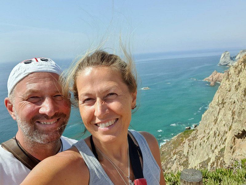
Cabo da Roca, Estrada do Cabo da Roca, Colares, Portugal
Estrada do Cabo da Roca s/n, 2705-001 Colares, Portugal
38° 46' 49.5" N 9° 29' 56" W
38.7804170 -9.4988850
• Follow the roundabout. Go for 36 m.
• Take the 1st exit from roundabout. Go for 189 m.
• Turn right onto Estrada do Cabo da Roca (N247-4). Go for 2.2 km.
• Continue on N247-4. Go for 39 m.
• Turn left toward Rua da Escola Nova. Go for 19 m.
• Turn right onto Rua da Escola Nova. Go for 259 m.
• Turn left onto Estrada do Cabo da Roca (N247-4). Go for 92 m.
• Turn right onto N247. Go for 4.9 km.
• Turn left onto Avenida de Nossa Senhora da Assunção (N247-5). Go for 216 m.
• Continue on Rua de Cascais (N9-1). Go for 2.7 km.
• Pass 2 roundabouts and continue on Estrada da Malveira da Serra (N9-1). Go for 1.1 km.
• Take ramp. Go for 347 m.
• Continue on A5 (Autoestrada da Costa do Estoril). Go for 16.3 km.
• Take exit 6 toward Loures/A1/A8/A10 onto A9 (CREL). Go for 19.6 km.
• Take exit 5 toward Leiria onto A8 (Autoestrada do Oeste). Go for 97.7 km.
• Take exit 22 toward Nazaré. Go for 978 m.
• Take the 2nd exit from roundabout onto N8-5 toward Tomar/Nazaré. Go for 663 m.
• Take the 3rd exit from roundabout onto N8-5 toward Nazaré. Go for 228 m.
• Take the 2nd exit from roundabout onto Avenida da Nazaré (N8-5). Go for 1.9 km.
• Continue on N8-5. Go for 1.9 km.
• Take the 1st exit from roundabout. Go for 61 m.
• Arrive at your destination on the left.
☍
151,5 km
(1 hrs. 38 min.)
Camping Orbitur Valado, Rua dos Combatentes do Ultramar, Nazaré, Portugal
Rua dos Combatentes do Ultramar 2, 2450-148 Nazaré, Portugal
39° 35' 56.2" N 9° 3' 23.1" W
39.5989408 -9.0564178
• Head southwest. Go for 51 m.
• Take the 3rd exit from roundabout onto N8-5 toward Valado dos Frades. Go for 2.0 km.
• Continue on Avenida da Nazaré (N8-5). Go for 1.8 km.
• Take the 2nd exit from roundabout onto N8-5. Go for 237 m.
• Take the 2nd exit from roundabout onto N8-5 toward Alcobaça/A8. Go for 664 m.
• Take the 3rd exit from roundabout onto A8 (Autoestrada do Oeste) toward Leiria. Go for 20.6 km.
• Take the exit toward Leiria Sul/A1/N242/M.nha Grande onto A8 (Nó da A8-A17). Go for 12.6 km.
• Take exit 29 toward Lisboa/Porto/A1 onto A8-1. Go for 2.5 km.
• Take ramp onto A1 (Autoestrada do Norte) toward Lisboa/Fátima. Go for 15.0 km.
• Take exit 8 toward N356/Fátima/(IC9)/Batalha. Go for 1.5 km.
• Take ramp onto Avenida João XXIII (N356) toward Rotunda Sul/Ourém/Tomar. Go for 1.9 km.
• Take the 2nd exit from Rotunda dos Pastorinhos roundabout onto Avenida Irmã Lúcia de Jesus (N356) toward Ourém/Tomar. Go for 1.4 km.
• Continue on Avenida Irmã Lúcia de Jesus. Go for 158 m.
• Arrive at Avenida Irmã Lúcia de Jesus. Your destination is on the right.
☍
60,5 km
( 39 min.)
Day
Fatima, Portugal
2495 Fatima, Portugal
39° 37' 1" N 8° 39' 7.3" W
39.6169407 -8.6520361
• Head toward Rua da Cooperativa on Avenida Irmã Lúcia de Jesus. Go for 8 m.
• Continue on Estrada Nossa Senhora da Ortiga. Go for 57 m.
• Turn right toward Rua da Cooperativa. Go for 60 m.
• Turn right onto Rua da Cooperativa. Go for 61 m.
• Turn left onto Avenida Irmã Lúcia de Jesus. Go for 1.5 km.
• Take the 4th exit from Rotunda dos Pastorinhos roundabout onto Avenida João XXIII (N356). Go for 1.6 km.
• Take ramp toward Lisboa/Porto. Go for 1.3 km.
• Keep left toward Lisboa/T.res Novas. Go for 97 m.
• Take ramp onto A1 (Autoestrada do Norte). Go for 20.9 km.
• Take exit 7 toward Abrantes/T.res Novas/Alcanena onto A23 (Autoestrada da Beira Interior). Go for 215 km.
• Continue on A25 (Autoestrada Beiras Litoral e Alta). Go for 35.3 km.
• Continue on A-62 (Autovía de Castilla). Go for 204 km.
• Keep right onto A-62 (Autovía de Castilla) toward Valladolid/Burgos. Go for 145 km.
• Continue on BU-30 (Autovía de Castilla). Go for 4.3 km.
• Continue on A-1 (Nudo de Landa). Go for 7.1 km.
• Continue on AP-1 (Autovía del Norte). Go for 81.9 km.
• Take the left exit onto A-1 (Autovía del Norte). Go for 24.7 km.
• Take exit 352 toward E-80/Francia/AP-1/Bilbao/AP-68/Aireportua onto N-622. Go for 2.3 km.
• Take ramp toward Aireportua/Foronda/Etxabarri-Ibiña/Donostia/AP-1/San Sebastián. Go for 273 m.
• Keep left toward Autopista Vitoria-Eibar/AP-1. Go for 862 m.
• Take ramp onto AP-1 (Autopista Vitoria-Eibar) toward Donostia/San Sebastián. Go for 44.7 km.
• Take the exit onto AP-1/AP-8 (Autopista del Cantábrico). Go for 42.6 km.
• Take the exit toward Hernani/Pasaia/Irun/Baiona/Bordeaux onto AP-1/AP-8 (Segundo Cinturón de San Sebastián). Go for 14.6 km.
• Take the exit onto AP-8. Go for 12.7 km.
• Continue on A63 (Autoroute de la Côte Basque). Go for 26.7 km.
• Take exit 5 toward Bayonne/Anglet/St Jean P. de Port/Cambo les Bains/Ustaritz. Go for 661 m.
• Take the 2nd exit from Rond-Point de Compagnet roundabout onto Avenue du 8 Mai 1945 (D932) toward Bassussarry/Ustaritz/Cambo/St Jean Pied de Port. Go for 2.5 km.
• Pass 3 roundabouts and continue on Route de Kapito Harri (D932). Go for 5.1 km.
• Take the 2nd exit from Giratoire de Kapito Harri roundabout onto Route de Belharitza (D932) toward Ustaritz/Cambo/St Jean Pied de Port/Espelette/Ainhoa/Dancharia. Go for 1.6 km.
• Take the 2nd exit from roundabout onto Route de Belharitza (D932). Go for 881 m.
• Take the 3rd exit from roundabout onto D932 toward Cambo/St Jean Pied de Port. Go for 1.9 km.
• Take the 3rd exit from roundabout onto D932 toward Cambo/Arnage. Go for 4.3 km.
• Take the 1st exit from roundabout onto D918 toward St Jean Pied de Port/Itxassou. Go for 971 m.
• Pass 2 roundabouts and continue on D918. Go for 30.1 km.
• Turn left onto Place Charles de Gaulle. Go for 24 m.
• Arrive at your destination on the right.
☍
936,2 km
(8 hrs. 28 min.)
Day
Saint-Jean-Pied-de-Port, Frankreich
64220 Saint-Jean-Pied-de-Port, Frankreich
43° 9' 47.3" N 1° 14' 17.2" W
43.1631410 -1.2381100
• Head southeast. Go for 11 m.
• Continue on Place Charles de Gaulle. Go for 13 m.
• Turn left onto Route d'Arnéguy à Baigt (D933). Go for 478 m.
• Take the 2nd exit from roundabout onto Avenue du Jaï-Alaï (D933) toward Pau/St Palais/Mauléon/Ispoure/St Jean le Vieux/Château d'Iholdy. Go for 2.7 km.
• Take the 2nd exit from roundabout onto D933 toward Pau/St Palais. Go for 12.1 km.
• Take the 2nd exit from roundabout onto Route de Saint-Palais (D933) toward Pau/Ostabat/St Palais/Salies de Béarn. Go for 8.6 km.
• Continue on D302. Go for 211 m.
• Continue on D933. Go for 4.7 km.
• Take the 2nd exit from roundabout onto D933 toward A64/Pau. Go for 1.7 km.
• Pass 2 roundabouts and continue on Avenue de la Gare (D933). Go for 11.4 km.
• Take the 2nd exit from roundabout onto Avenue de la Gare (D933) toward A64/Salies de Béarn. Go for 848 m.
• Pass 2 roundabouts and continue on D933. Go for 7.2 km.
• Continue on D430 toward Pau/Orthez. Go for 2.6 km.
• Take the 2nd exit from roundabout onto D430 toward Bellocq/Puyoo/Dax. Go for 4.4 km.
• Take the 3rd exit from roundabout onto A64 (La Pyrénéenne) toward Pau. Go for 196 km.
• Take exit 25 toward St Élix le Château/St Julien/Rieux-Vtre/Montesquieu-Vtre. Go for 377 m.
• Take the 1st exit from roundabout onto D25 toward Tarbes/Lourdes/St Élix le Château. Go for 387 m.
• Continue on Rue du Coin du Trou (D25). Go for 307 m.
• Turn left onto Rue du Château (D25) toward Le Fousseret. Go for 83 m.
• Turn right onto Rue de la Carrerasse. Go for 174 m.
• Continue on Rue des Écoliers (D10 C). Go for 176 m.
• Turn left onto Route de Lafitte (D49) toward Lafitte-V./Lavernose-L. Go for 2.4 km.
• Continue on Allées Charles de Rémusat (D49). Go for 753 m.
• Continue on D626 B. Go for 2.2 km.
• Take the 2nd exit from roundabout onto D626 toward Toulouse/Carbonne/Salles S/Gne. Go for 2.4 km.
• Turn right onto Avenue Pierre Marty (D626 B). Go for 666 m.
• Turn left onto Route de l'Arize (D627). Go for 542 m.
• Take the 4th exit from roundabout onto D627. Go for 1.0 km.
• Take the 4th exit from roundabout onto Route du Lançon (D627). Go for 596 m.
• Pass 2 roundabouts. Go for 532 m.
• Take ramp onto A64 (La Pyrénéenne). Go for 33.2 km.
• Take the exit toward Albi/Montpellier/Foix/Toulouse-Centre/Empalot onto A620 (Échangeur de la Croix de Pierre). Go for 7.2 km.
• Keep right onto Échangeur du Palays toward Bordeaux/A68/Albi/Montaudran. Go for 967 m.
• Continue on A61 (Échangeur du Palays). Go for 9.1 km.
• Take the exit toward Lavaur/Albi/Castres onto A68. Go for 62.1 km.
• Continue on N88. Go for 13.6 km.
• Pass 2 roundabouts and continue on N88. Go for 2.2 km.
• Keep left onto N88 toward Carmaux/Rodez. Go for 763 m.
• Take the 2nd exit from Giratoire de l'Hermet roundabout onto N88 toward Carmaux/Rodez. Go for 3.7 km.
• Take the 1st exit from Giratoire de la Tête roundabout onto N88 toward Rodez/Valderiès/Tanus. Go for 56.2 km.
• Keep left onto N88 toward Rodez/C.H.S. Ste-Marie. Go for 4.3 km.
• Pass 2 roundabouts and continue on Rocade de Saint-Mayme (N88). Go for 2.3 km.
• Take the 3rd exit from Giratoire de Saint-Marc roundabout onto Rocade de Saint-Mayme (N88) toward A75/Millau/Mende/Clermont-Ferrand/Laissac/Sévérac le Château. Go for 1.7 km.
• Take the 2nd exit from roundabout onto D1088 toward Espalion/Bozouls/Z.A. de Lioujas. Go for 3.1 km.
• Take the 2nd exit from roundabout onto D1088 toward Aurillac/Espalion/Bozouls. Go for 3.5 km.
• Continue on D988. Go for 9.6 km.
• Take the 2nd exit from roundabout onto Route d'Espalion (D920) toward Espalion/Z.A. les Calsades. Go for 549 m.
• Take the 2nd exit from roundabout onto Route d'Espalion (D920) toward Aurillac/Clermont-Fd/Espalion/Stations de l'Aubrac. Go for 4.7 km.
• Turn right onto Lieu-dit Les Quatre Routes (D920) toward Espalion-Centre/Station de l'Aubrac/Château de Calmont/Les 4 Routes. Go for 4.0 km.
• Take the 2nd exit from roundabout onto Boulevard de Guizard (D921). Go for 103 m.
• Continue on Avenue de Saint-Côme (D987) toward St Côme d'Olt/St Géniez d'Olt/St Chély d'Aubrac/Station de Brameloup. Go for 3.2 km.
• Continue on D987. Go for 1.3 km.
• Take the 3rd exit from roundabout onto Avenue de l'Argent (D987). Go for 51.9 km.
• Continue on Avenue de Peyre (D809). Go for 218 m.
• Turn right onto Route de la Margeride (D7). Go for 939 m.
• Turn left onto Route des Estrets (D7). Go for 358 m.
• Continue on D7. Go for 2.3 km.
• Continue on Lieu-dit Buffeyrettes (D7). Go for 277 m.
• Continue on D7. Go for 2.8 km.
• Turn right onto D806. Go for 349 m.
• Turn left onto D7 toward Fontans/St Denis en M./Ste Eulalie. Go for 29 m.
• Continue on Lieu-dit Les Estrets (D7). Go for 362 m.
• Continue on D7. Go for 1.1 km.
• Continue on Lieu-dit Ponges (D7). Go for 240 m.
• Continue on D7. Go for 2.6 km.
• Continue on Lieu-dit Le Comte (D7). Go for 148 m.
• Continue on D7. Go for 1.3 km.
• Turn right onto D58. Go for 4.8 km.
• Continue on D5. Go for 1.2 km.
• Continue on Lieu-dit Le Couderc (D5). Go for 151 m.
• Continue on D5. Go for 4.8 km.
• Continue on Lieu-dit Baraques des Bouviers (D5). Go for 35 m.
• Continue on D5. Go for 10.3 km.
• Turn left onto D985. Go for 1.1 km.
• Turn right onto Route du Puy (D5). Go for 467 m.
• Continue on Lieu-dit Beauregard (D5). Go for 88 m.
• Continue on Route du Puy (D5). Go for 1.8 km.
• Continue on D5. Go for 3.8 km.
• Continue on Lieu-dit Laval Haut (D5). Go for 113 m.
• Continue on D5. Go for 521 m.
• Continue on Lieu-dit La Bastide (D5). Go for 77 m.
• Continue on D5. Go for 343 m.
• Turn right onto D5. Go for 159 m.
• Turn left onto D5. Go for 25 m.
• Continue on D988. Go for 8.4 km.
• Continue on D88. Go for 130 m.
• Turn left onto Lieu-dit Le Nouveau Monde (D31). Go for 269 m.
• Continue on D31. Go for 3.4 km.
• Turn left onto D40. Go for 26 m.
• Continue on D31. Go for 7.6 km.
• Turn left onto D31. Go for 2.0 km.
• Continue on Route du Lac (D31). Go for 943 m.
• Continue on Rue Centrale (D31). Go for 373 m.
• Continue on D31. Go for 8 m.
• Turn right onto Route du Puy (D33). Go for 516 m.
• Continue on Lotissement La Gagne (D33). Go for 555 m.
• Continue on D33. Go for 4.3 km.
• Turn left onto N88. Go for 1.0 km.
• Take the 1st exit from roundabout onto Route du Midi (N88) toward Le Puy en Velay. Go for 3.8 km.
• Pass 2 roundabouts and continue on N88. Go for 6.9 km.
• Take ramp toward Le Puy-en-Velay-Centre. Go for 544 m.
• Take the 4th exit from roundabout onto Avenue des Belges (D373) toward Montélimar/Aubenas/Mende/Le Puy-en-Velay-Centre/Pôle d'Échange Intermodal. Go for 137 m.
• Take the 1st exit from roundabout onto Avenue des Belges (D373) toward Le Puy-en-Velay-Centre/Pôle d'Échange Intermodal. Go for 328 m.
• Turn right onto Avenue des Belges toward Centre Ville. Go for 653 m.
• Turn right onto Boulevard Maréchal Joffre (D188). Go for 195 m.
• Turn left onto Boulevard de Cluny (D13) toward Clermont-Fd/Aurillac/Vichy/Thiers. Go for 481 m.
• Take the 2nd exit from roundabout onto Rocade d'Aiguilhe (D13) toward Clermont-Fd/Aurillac/Vichy. Go for 578 m.
• Turn right onto Avenue de Bonneville. Go for 50 m.
• Turn left. Go for 25 m.
• Arrive at your destination.
☍
631,2 km
(7 hrs. 17 min.)
Day
Camping du Puy-en-Velay - Aquadis Loisirs, Avenue de Bonneville, Aiguilhe, Frankreich
Av. de Bonneville, 43000 Aiguilhe, Frankreich
45° 3' 1.5" N 3° 52' 50.8" E
45.0504161 3.8807818
• Head east. Go for 25 m.
• Turn right onto Avenue de Bonneville. Go for 478 m.
• Turn left onto Boulevard Carnot toward Aubenas/Mende/Montélimar/Centre Ville. Go for 270 m.
• Turn left onto Rue Pannessac. Go for 241 m.
• Continue on Rue Courrerie. Go for 99 m.
• Turn right onto Place du Martouret. Go for 35 m.
• Turn right onto Rue Saint-Pierre. Go for 41 m.
• Continue on Place de la Halle. Go for 26 m.
• Turn left onto Place de la Halle. Go for 32 m.
• Arrive at Place de la Halle. Your destination is on the left.
☍
1,2 km
( 3 min.)
Day
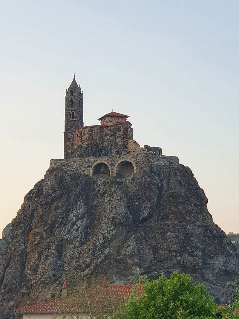
Le Puy-en-Velay, Frankreich
43000 Le Puy-en-Velay, Frankreich
45° 2' 34" N 3° 52' 58.6" E
45.0427680 3.8829360
• Head south on Place de la Halle. Go for 79 m.
• Turn left onto Place de la Halle. Go for 26 m.
• Continue on Rue Saint-Pierre. Go for 34 m.
• Continue on Rue Saint-Jacques. Go for 159 m.
• Turn left onto Boulevard Saint-Louis (D590). Go for 383 m.
• Continue on Place Michelet. Go for 195 m.
• Turn right onto Avenue Georges Clemenceau (D188). Go for 87 m.
• Keep right onto Rue Pierre Farigoule toward Guitard/Ours/Mons/Coloin. Go for 220 m.
• Continue on Boulevard Bertrand de Doue (D373) toward Guitard/Ours/Mons/Coloin. Go for 1.4 km.
• Take the 2nd exit from roundabout onto Avenue des Belges (D373) toward Zone Industrielle Corsac-Chassende. Go for 121 m.
• Take the 3rd exit from roundabout onto N88 toward Valence/Annonay/St Étienne/Yssingeaux. Go for 10.4 km.
• Take the 2nd exit from roundabout onto N88 toward St Étienne/Annonay/St Hostien/Yssingeaux. Go for 69.5 km.
• Keep left onto A47 toward E70/St Chamond-Stelytec/Lyon/Valence. Go for 29.4 km.
• Take the left exit toward Lyon-Centre onto A7 (Autoroute du Soleil). Go for 12.9 km.
• Take the exit toward Genève/Grenoble/St Fons onto D383 (Boulevard Pierre Sémard). Go for 2.7 km.
• Keep right onto D383 toward Paris/Genève/Grenoble/Chambéry/Périphérique/Porte du Moulin à Vent. Go for 814 m.
• Keep left onto Boulevard Laurent Bonnevay (D383) toward Chambéry/Grenoble/Bourg/Genève/Paris/Vénissieux/Villeurbanne. Go for 3.4 km.
• Keep left onto Boulevard Laurent Bonnevay (D383) toward Bourg/Genève/Paris/Villeurbanne/Bron-Centre. Go for 2.5 km.
• Keep left onto Boulevard Laurent Bonnevay (D383) toward Bourg/Genève/Paris/Lyon-Centre/Villeurbanne-Centre. Go for 4.5 km.
• Take ramp onto A42 (Pont de Croix Luizet) toward Genève/Rocade Est. Go for 3.2 km.
• Take the left exit toward Paris/Genève/Bourg en B./Aéroport Saint Exupéry onto A42/A46. Go for 1.1 km.
• Take the exit toward Bourg en B./Genève/Strasbourg/Aéroport Saint-Exupéry onto A42. Go for 49.0 km.
• Continue on A40. Go for 23.0 km.
• Keep left onto A39 (Autoroute Verte) toward Strasbourg/Lille/Paris Par A5/Dijon/Lons le S. Go for 111 km.
• Take the exit toward Strasbourg/Besançon/Dole/Authume onto A36 (La Comtoise). Go for 123 km.
• Keep left onto A36 (La Comtoise) toward Strasbourg/Mulhouse/Belfort/Montbéliard. Go for 74.2 km.
• Continue on A5. Go for 191 m.
• Take the left exit toward Karlsruhe/Stuttgart/Freiburg onto A5. Go for 35.4 km.
• Take exit 62 toward Donaueschingen/Freiburg onto B31A. Go for 5.0 km.
• Keep left onto Autobahnzubringer Mitte (B31A) toward Donaueschingen/Titisee-Neustadt/FR-Stadtmitte. Go for 25.8 km.
• Keep left onto B31 toward Villingen-Schwenningen/Donaueschingen/Titisee-Neustadt/B500. Go for 34.2 km.
• Turn right and take ramp onto B27/B33 toward Stuttgart/Villingen-Schwenningen/Bad Dürrheim/Donaueschingen. Go for 8.9 km.
• Take ramp onto A864 toward Stuttgart/Singen. Go for 5.1 km.
• Take the exit toward Stuttgart onto A81. Go for 67.2 km.
• Take exit 29 toward Rottenburg a.N./Tübingen onto B28. Go for 18.6 km.
• Turn left and take ramp onto Hegelstraße (B28). Go for 11.7 km.
• Take ramp toward Rt.-Zentrum/Hohbuch/Krankenhaus. Go for 177 m.
• Turn slightly left onto B464. Go for 1.1 km.
• Turn left. Go for 19 m.
• Arrive at your destination on the right.
☍
736,9 km
(7 hrs. 17 min.)
Day
Reutlingen, Deutschland
48° 29' 28.5" N 9° 12' 16.7" E
48.4912389 9.2046411