Scandinavia tour, summer holidays 2022
from Mon 25.07. until Fri 08/12/2022
with mobile home, 2 people
Start/End: Hamburg
Tour: Hamburg-Hirtshals-Kristiansand-Norway West Coast-Oslo-Stockholm-Sweden East Coast-Copenhagen-Hamburg
Day
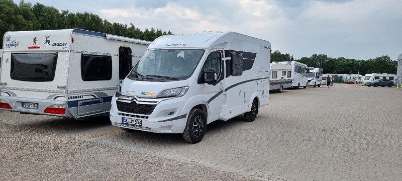
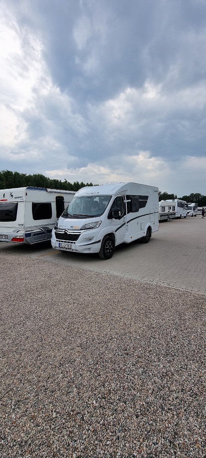
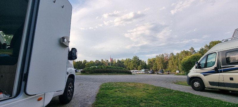
Kayhude, Deutschland
Start / Vehicle pick-up
We booked through TUI
the vehicle was brokered via MC Rent Kayhude
first big purchase in the neighboring village, 23866 Nahe
Parkplatz, Segeberger Str. 5, 23863 Kayhude, Deutschland
53° 44' 58.2" N 10° 7' 30.5" E
53.7494969 10.1251450
• Head north on Heidkrügerfeld. Go for 57 m.
• Turn right onto Heidkrügerfeld. Go for 53 m.
• Turn right onto Segeberger Straße (B432). Go for 3.1 km.
• Turn right onto Hauptstraße (K51) toward Tangstedt. Go for 3.1 km.
• Turn left onto Dorfring (K81). Go for 371 m.
• Continue on Harksheider Straße (K81). Go for 3.2 km.
• Turn right onto Schleswig-Holstein-Straße (L284) toward A7/Flensburg/Kiel/Kaltenkirchen/Henstedt-Ulzburg. Go for 4.0 km.
• Continue on Kohtla-Järve-Straße (K113) toward Hamburg/A7/Flensburg/Kiel/Quickborn. Go for 2.2 km.
• Continue on Friedrichsgaber Straße (K24). Go for 1.4 km.
• Turn left and take ramp onto A7 toward Flensburg/Kiel. Go for 48.9 km.
• Keep right onto A215 (Autobahndreieck Bordesholm) toward Kiel. Go for 19.6 km.
• Take the exit toward Eckernförde/Olympiazentrum/B503 onto B76 (Olof-Palme-Damm). Go for 4.5 km.
• Keep right onto Olof-Palme-Damm (B76) toward Eckernförde/Holsteinstadion. Go for 296 m.
• Keep left onto Olof-Palme-Damm (B76) toward Eckernförde/Kiel-Suchsdorf. Go for 486 m.
• Keep left onto Olof-Palme-Damm (B76). Go for 9.0 km.
• Keep left onto B76. Go for 14.2 km.
• Continue on Flensburger Straße (B76/B203) toward Flensburg/Kappeln/Damp/Gewerbegebiet Nord. Go for 2.5 km.
• Take ramp onto B203 toward Kappeln/Damp/Krankenhaus. Go for 380 m.
• Keep left onto Schwansenstraße (B203) toward Kappeln/Damp. Go for 24.3 km.
• Continue on B203 toward Kappeln. Go for 485 m.
• Continue on B201. Go for 488 m.
• Continue on Hospitalstraße (B203) toward A7/Flensburg/B199/Schleswig. Go for 698 m.
• Keep right onto Nordstraße (B199) toward Flensburg/Gelting/Gewerbegebiet Mehlby. Go for 1.5 km.
• Take the 2nd exit from roundabout onto Nordstraße (B199). Go for 11.0 km.
• Turn right onto Norderholm (K58/K111) toward Nieby/Pommerby. Go for 632 m.
• Continue on Gelting (K58/K111). Go for 157 m.
• Turn left onto Goldhöft. Go for 1.7 km.
• Turn left onto Beveroe. Go for 679 m.
• Turn right. Go for 29 m.
• Arrive at your destination on the left.
☍
159,1 km
(1 hrs. 51 min.)
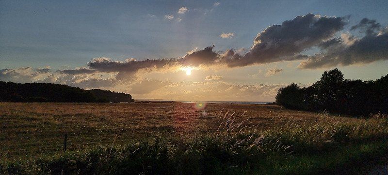
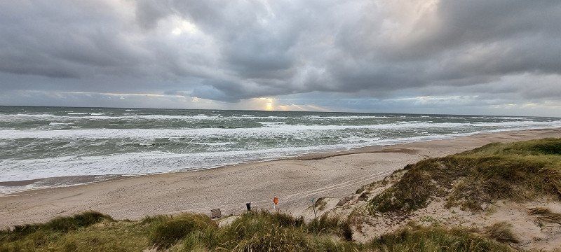
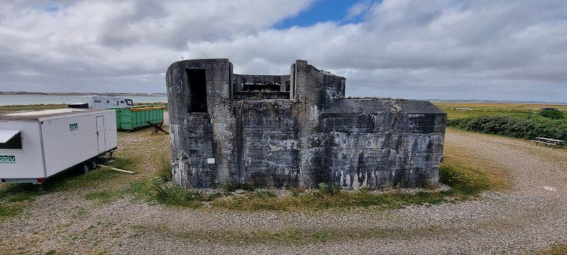
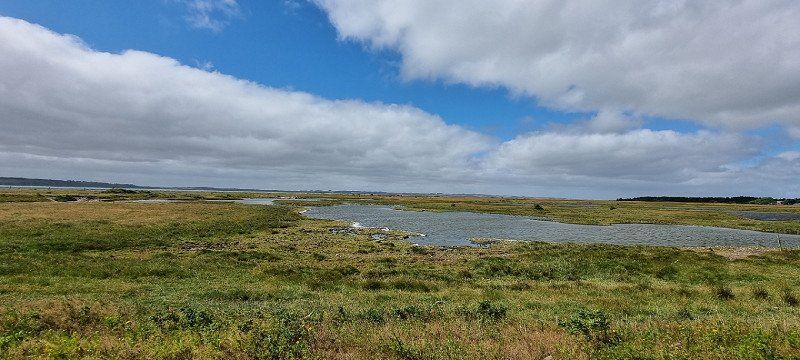
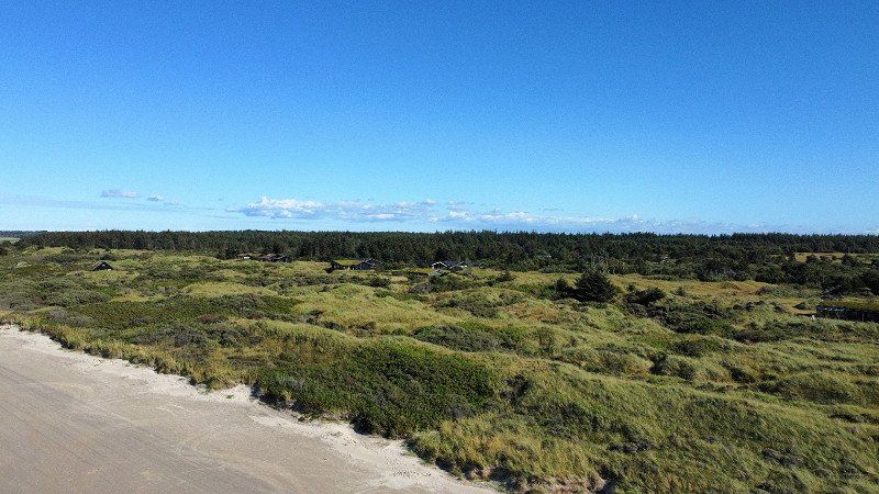
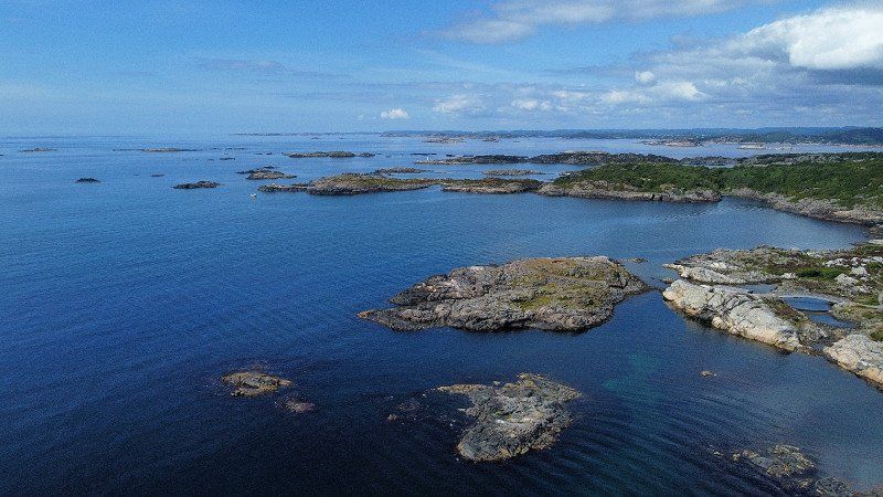
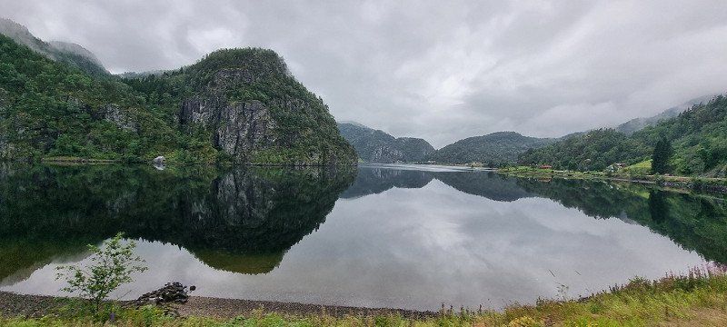
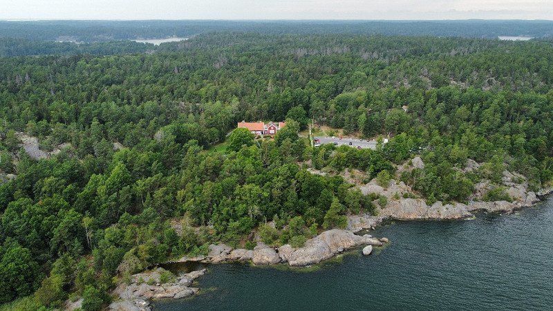
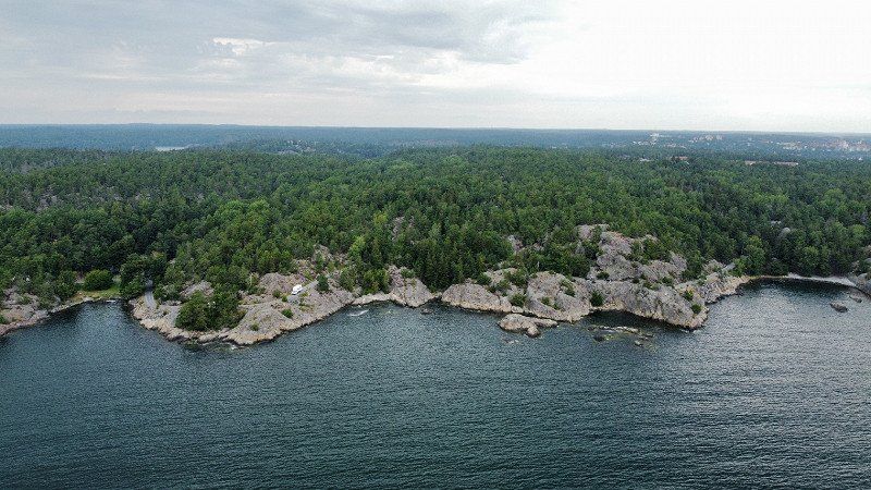
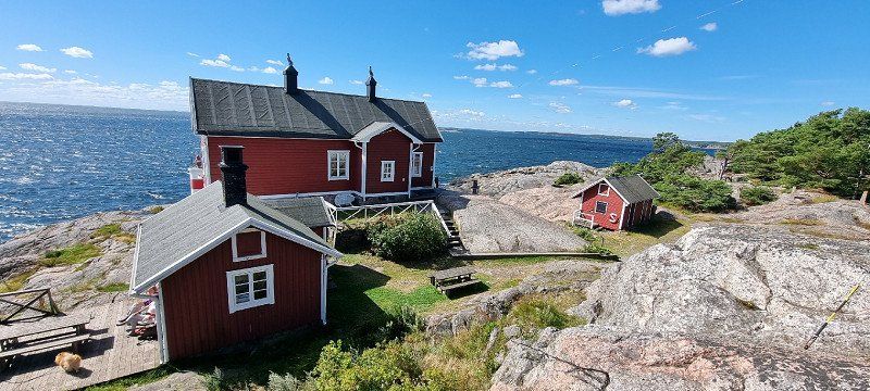
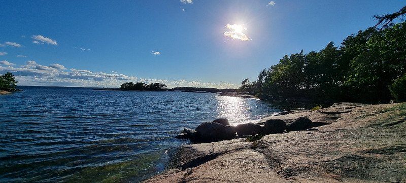
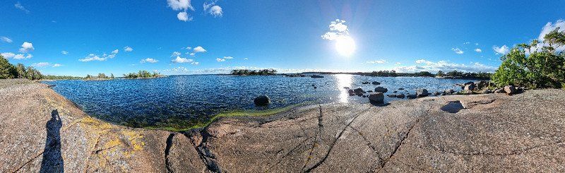
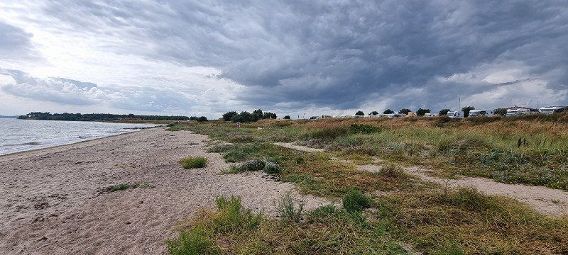
Geltinger Birk, Deutschland
1st overnight stay
Location: Parking lot at the Geltinger Birk
beautiful place in a nature reserve
at the driveway, the first sight blew us away (cover photo)
Unfortunately we were traveling without a bike
the area could have been explored a little better by bike
a paradise for bird watchers
Beveroe 1a, 24395 Nieby, Deutschland
54° 46' 9.5" N 9° 54' 27.6" E
54.7693134 9.9076555
• Head west. Go for 29 m.
• Turn left onto Beveroe. Go for 679 m.
• Turn right onto Goldhöft. Go for 1.7 km.
• Turn right onto Gelting (K58/K111). Go for 157 m.
• Continue on Norderholm (K58/K111). Go for 632 m.
• Turn right onto Nordstraße (B199). Go for 31.8 km.
• Turn right onto Nordstraße (K28). Go for 1.6 km.
• Turn left onto Hafendamm (K28). Go for 581 m.
• Turn right onto Norderhofenden (L16). Go for 1.6 km.
• Continue on Werftstraße (K10). Go for 2.2 km.
• Turn right and take ramp onto B200. Go for 2.7 km.
• Continue on Flensborgvej (170). Go for 4.3 km.
• Take ramp onto E45 (Sønderjyske Motorvej) toward Kolding/E45N/Aabenraa/42. Go for 73.7 km.
• Take exit 64 toward Esbjerg onto E20. Go for 61.6 km.
• Take exit 75 toward Esbjerg N/Blåvand/Esbjerg V. Go for 614 m.
• Take the 1st exit from roundabout onto Vestkystvej (12/463) toward Blåvand/Varde. Go for 2.4 km.
• Take the 1st exit from roundabout onto Vestkystvej (12/463) toward Blåvand/Varde. Go for 15.6 km.
• Take the 3rd exit from roundabout onto Vesterhavsvej (431). Go for 1.4 km.
• Continue on Blåvandvej (431). Go for 8.7 km.
• Turn right onto Blåvandvej (431). Go for 7.1 km.
• Continue on Fyrvej. Go for 1.5 km.
• Turn right onto Fyrvej. Go for 49 m.
• Arrive at Fyrvej. Your destination is on the right.
☍
220,8 km
(2 hrs. 30 min.)
Day
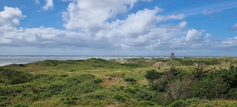
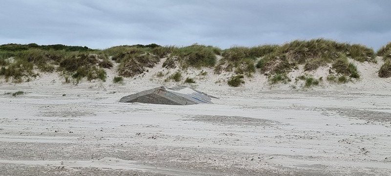
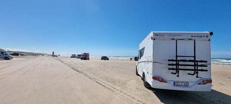
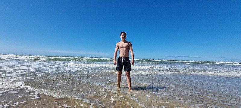
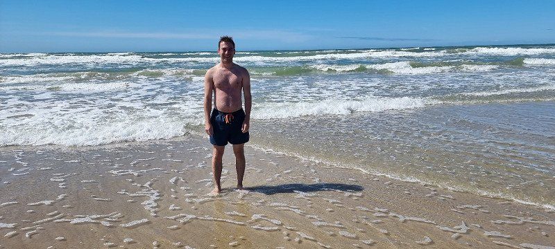
Blåvandshuk, Dänemark
Lighthouse (visit costs), good sandy beach
Anti-aircraft tower and bunker from WWII
the northern part from the lighthouse is a restricted military area
Unfortunately, it was windy from the North Sea that day and too cold to go swimming
A stop should definitely be made in Blåvand
there are many shops and also souvenir shops
really great
6857 Blåvand, Dänemark
55° 33' 10.7" N 8° 6' 13.2" E
55.5529860 8.1036766
• Head south on Fyrvej. Go for 49 m.
• Turn left onto Fyrvej. Go for 1.5 km.
• Continue on Blåvandvej. Go for 7.0 km.
• Turn left onto Blåvandvej (431). Go for 5.7 km.
• Turn left onto Strandvejen. Go for 1.9 km.
• Turn left onto Kirkegade. Go for 888 m.
• Continue on Baunhøjvej. Go for 2.5 km.
• Continue on Troldholmvej. Go for 1.7 km.
• Continue on Jegumvej. Go for 1.8 km.
• Continue on Mønstervej. Go for 2.3 km.
• Turn left onto Strandvejen (465). Go for 5.6 km.
• Turn right onto Blåbjergvej. Go for 4.0 km.
• Turn left onto Houstrupvej. Go for 3.6 km.
• Turn left onto Vesterhavsvej (181). Go for 25.9 km.
• Pass 4 roundabouts and continue on Holmsland Klitvej (181). Go for 14.0 km.
• Take the 3rd exit from roundabout onto Søndervig Landevej (15). Go for 440 m.
• Turn right onto Houvig Klitvej (181). Go for 12.6 km.
• Turn left onto Husby Klitvej. Go for 74 m.
• Turn slightly left. Go for 235 m.
• Arrive at your destination on the right.
☍
91,8 km
(1 hrs. 29 min.)
Husby Klitvej, 6990 Øby, Dänemark
2nd overnight stay
Location: Parking near Husby Klitvej (Øby)
lonely parking lot, a bit off the main road
a short jump over the dunes and you are at the North Sea
unfortunately partly some rain and very stormy
it partially blew the sand in our faces and our clothes during the ascent
is recommended when the weather is nice and there is little wind
Dänemark
56° 13' 40.7" N 8° 8' 6.8" E
56.2279625 8.1352344
• Head toward Husby Klitvej. Go for 235 m.
• Turn slightly right onto Husby Klitvej. Go for 74 m.
• Turn left onto Husby Klitvej (181). Go for 6.2 km.
• Turn right onto Stabyvej (537). Go for 8.4 km.
• Continue on Harbogade (537). Go for 978 m.
• Turn left onto Holmegade (16/28) toward Holstebro/Lemvig. Go for 2.3 km.
• Turn left onto Vembvej (28) toward Struer/Lemvig/509/Vemb. Go for 5.6 km.
• Turn right onto Burvej (509). Go for 6.7 km.
• Turn left onto Lindtorpvej (509). Go for 6.4 km.
• Take the 2nd exit from roundabout onto Lindevej (509). Go for 7.0 km.
• Take the 1st exit from roundabout onto Vester Gimsingvej (509). Go for 2.5 km.
• Take the 3rd exit from roundabout onto Holstebrovej (11/513) toward Thisted/Lemvig/Struer. Go for 912 m.
• Continue on Holstebrovej (11/513). Go for 3.9 km.
• Take the 1st exit from roundabout onto Oddesundvej (11) toward Thisted. Go for 8.2 km.
• Turn left onto Hovedvejen. Go for 246 m.
• Turn slightly left onto Hovedvejen. Go for 13 m.
• Arrive at Hovedvejen. Your destination is on the right.
☍
59,7 km
( 53 min.)
Day
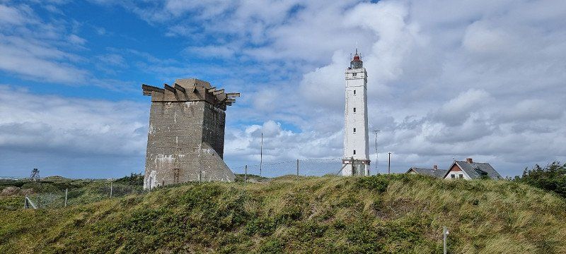
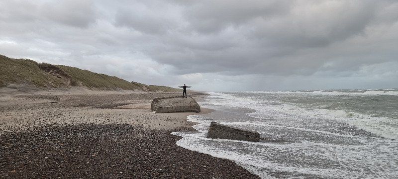
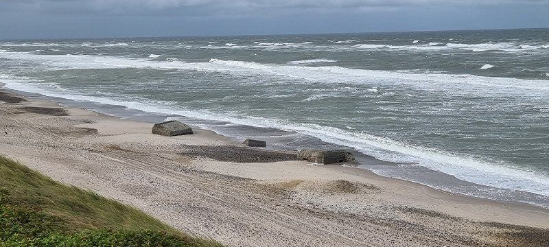
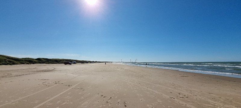
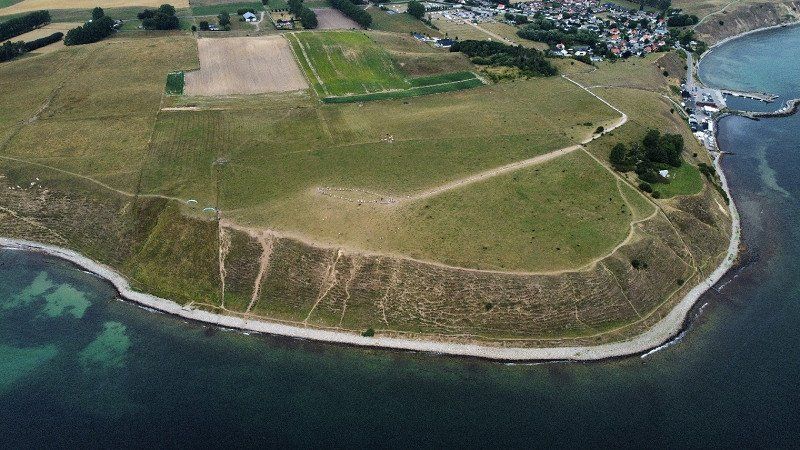
Oddesund, Dänemark
older road bridge + bunker from the 2nd WW
newer observation tower
there are currently some art installations to be seen in/next to the bunkers
you can learn a lot about history here!
Dänemark
56° 34' 42.4" N 8° 33' 12.8" E
56.5784375 8.5535625
• Head west on Hovedvejen. Go for 259 m.
• Turn left onto Hovedvejen (11). Go for 49.8 km.
• Pass 3 roundabouts and continue on Aalborgvej (11/29). Go for 46.1 km.
• Continue on Bygholmvejlevej (11) toward Aabybro/Aalborg. Go for 9.3 km.
• Turn left onto Mellemmøllevej toward Tranum/Lerup K. Go for 841 m.
• Continue on Bonderupvej. Go for 2.0 km.
• Turn right onto Hjortdalvej. Go for 3.5 km.
• Take the 2nd exit from roundabout onto Dybdalsvej. Go for 951 m.
• Continue on Drosselvej. Go for 12 m.
• Continue on Dybdalsvej. Go for 1.3 km.
• Continue on Tranum Engevej. Go for 5.0 km.
• Take the 2nd exit from roundabout onto Tranum Engevej. Go for 2.1 km.
• Continue on Tranumvej. Go for 4.7 km.
• Take the 3rd exit from roundabout onto Gammel Landevej. Go for 1.2 km.
• Continue on Sandmosevej. Go for 17 m.
• Continue on Gammel Landevej. Go for 1.3 km.
• Turn left onto Brogårdsvej (55). Go for 8.5 km.
• Pass 2 roundabouts and continue on Tinghøjgade (55). Go for 14.0 km.
• Take the 3rd exit from roundabout onto Ny Strandvej. Go for 1.2 km.
• Arrive at your destination on the left.
☍
152,1 km
(2 hrs. )
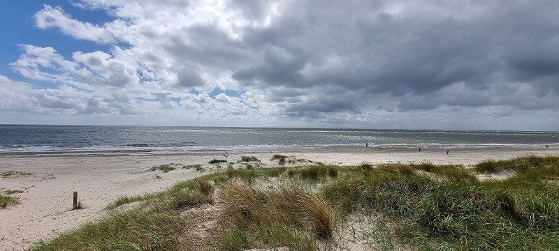
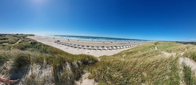
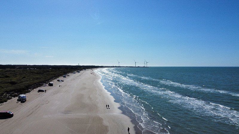
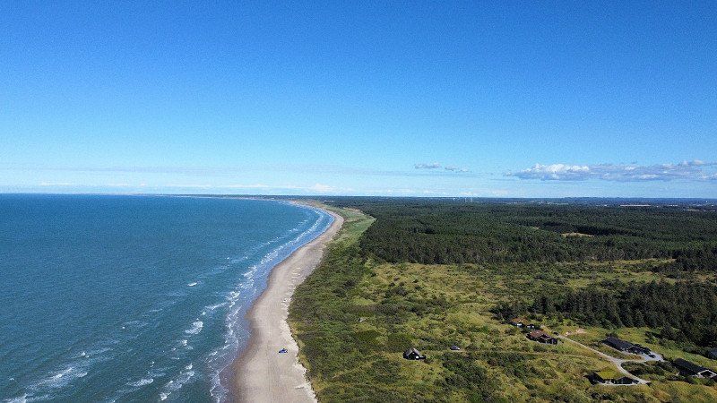
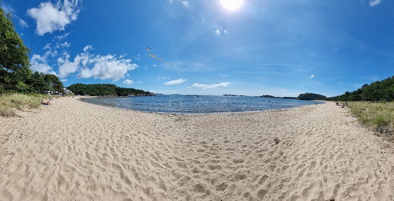
Løkken Strand, Dänemark
Sandy beach at Løkken
the beach is passable by car/camper
you can park directly at the North Sea
even if the water was a bit cold and it winded, it never hurt to cool down :)
Dänemark
57° 21' 39.8" N 9° 41' 45.8" E
57.3610625 9.6960625
• Head toward Majvej. Go for 250 m.
• Continue on Ny Strandvej. Go for 795 m.
• Take the 3rd exit from roundabout onto Løkkensvej (55) toward Hirtshals/Hjørring/35. Go for 1.8 km.
• Take the 2nd exit from roundabout onto Løkkensvej (55) toward Hirtshals/Hjørring/35. Go for 1.1 km.
• Continue on Løkkensvej (55) toward Hjørring. Go for 15.8 km.
• Take the 2nd exit from roundabout onto Krustrupvej (55) toward Hirtshals. Go for 2.7 km.
• Turn right onto Vellingshøjvej toward 190. Go for 3.5 km.
• Take the 3rd exit from roundabout onto Ringvejen (190). Go for 3.4 km.
• Take the 1st exit from roundabout onto Ramsvej toward Hirtshals/E39/Bjergby/Mygdal/Odden. Go for 163 m.
• Continue on Skagen Landevej. Go for 61 m.
• Turn left and take ramp onto E39 (Hirtshalsmotorvejen) toward Hirtshals/Skagen. Go for 6.1 km.
• Take the 1st exit from roundabout onto Tverstedvej (597) toward Skagen/Tversted. Go for 3.5 km.
• Arrive at Tverstedvej (597). Your destination is on the left.
☍
39,1 km
( 36 min.)
Kjul Camping, Dänemark
3rd overnight stay
Location: Kjul campsite, Hirtshals
Unfortunately, the "Hirtshals Camping" was fully booked, so we stayed at the "Kjul Strand Camping".
it was a very quiet campsite in the woods
from here you can walk directly to the beach in about 15 minutes
the beach itself is also very nice
we would stay here again
Kjulvej 12, 9850, Hirtshals, Dänemark
57° 34' 6" N 10° 4' 14" E
57.5683300 10.0705600
• Head west on Tverstedvej (597). Go for 3.5 km.
• Take the 1st exit from roundabout onto Aalborgvej (E39) toward Hirtshals. Go for 2.2 km.
• Take the 3rd exit from roundabout onto Dalsagervej (55) toward Tornby/Hirtshals S. Go for 184 m.
• Turn right onto Søndergade toward Hirtshals C. Go for 1.0 km.
• Take the 2nd exit from roundabout onto Søndergade. Go for 1.0 km.
• Take the 4th exit from roundabout onto Vestergade. Go for 582 m.
• Turn left onto Hjørringgade. Go for 15 m.
• Turn right onto Fiskergade. Go for 78 m.
• Turn left onto Kystvejen. Go for 105 m.
• Arrive at Kystvejen. Your destination is on the right.
☍
8,7 km
( 9 min.)
Day
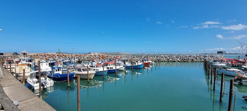
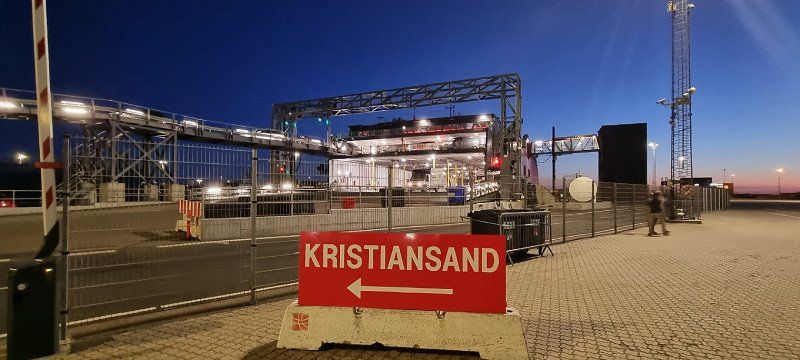
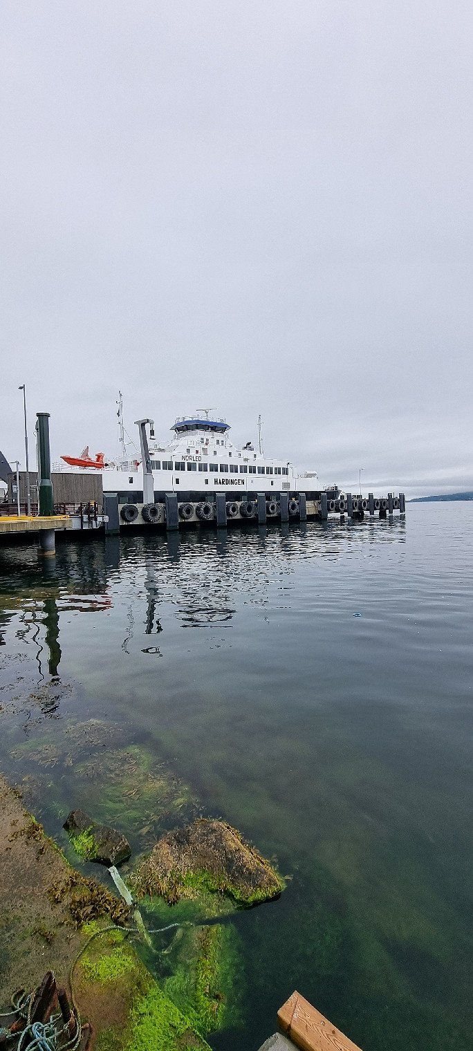
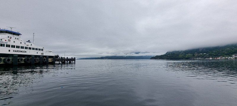
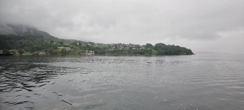
Hirtshals, Dänemark
Explore the harbor of Hirtshals + ferry crossing to Kristiansand
because we had to wait for the ferry, we explored the harbor of Hirtshals for the day
among other things, a music festival was running in the center
We then waited behind the Fjordline terminal on a small side square by the North Sea
at 11.30 p.m. (until 1.45 a.m., with Fjordline) we went to the ferry
you should have checked in at least 60 minutes before departure
When you check in you get a code on which line (e.g. C32) you could wait
Dänemark
57° 35' 18.4" N 9° 56' 53" E
57.5884375 9.9480625
• Head southwest on Kystvejen. Go for 113 m.
• Take the 3rd exit from roundabout onto Hjørringgade. Go for 270 m.
• Turn right onto Vestergade. Go for 505 m.
• Take the 2nd exit from roundabout onto Søndergade. Go for 1.0 km.
• Take the 2nd exit from roundabout onto Søndergade. Go for 1.0 km.
• Turn left onto Dalsagervej (55) toward Hjørring/E39/Skagen/579/Tversted. Go for 82 m.
• Take the 4th exit from roundabout onto Aalborgvej (E39) toward Hirtshals/Havn. Go for 1.5 km.
• Keep left onto E39 toward Color Line/Check-in. Go for 783 m.
• Take the Hirtshals-Kristiansand Ferry. Stay on for 139 km.
• Head northwest. Go for 412 m.
• Continue toward Havnegata. Go for 31 m.
• Turn right onto Havnegata. Go for 807 m.
• Arrive at Havnegata. Your destination is on the left.
☍
145,4 km
(4 hrs. 13 min.)
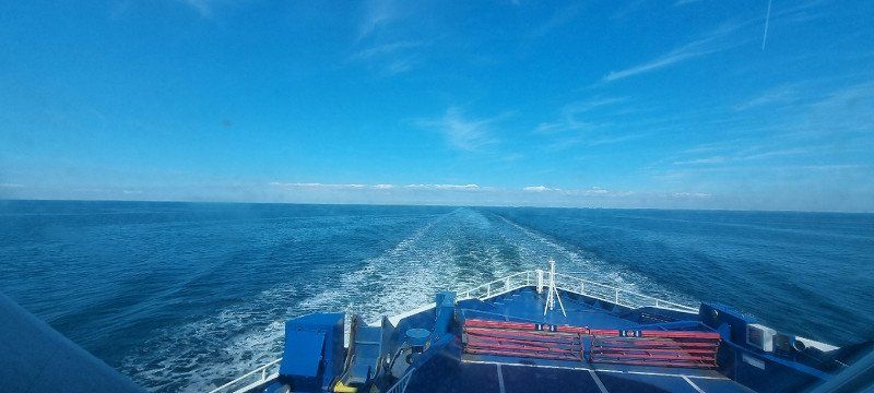
Kristiansand, Norwegen
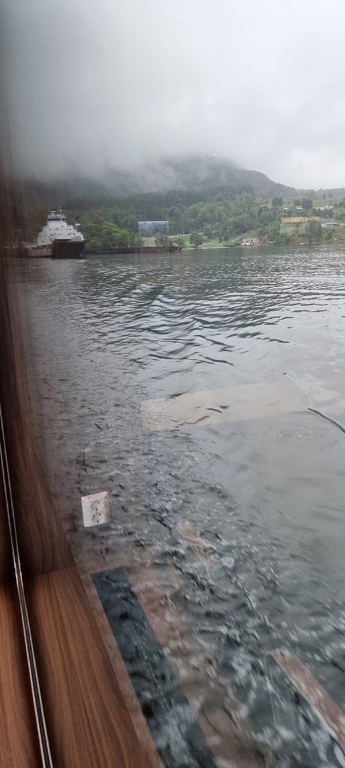
Ferry Hirtshals - Kristiansand
Thursday, July 28, 11:30 p.m. to Fri, July 29, 1:45 a.m
you will be super briefed by the folders
all campers and buses are parked below
all cars are transported to the upper deck via a ramp
on the top deck there is a duty-free shop, a refreshment stand and seating for the crossing
sleeping was not so pleasant
it gets very cold
long pants + a jacket is an advantage
the departure from the ferry + the exit in Kristiansand was again very orderly
if you arrive this late, you should definitely have a plan where you want to stay overnight
sometimes a large caravan of cars and campers, which was then distributed well
Norwegen
58° 8' 39.3" N 7° 59' 5.8" E
58.1442375 7.9849531
• Head east on Havnegata. Go for 203 m.
• Turn left toward Havnegata. Go for 40 m.
• Turn left onto Havnegata. Go for 390 m.
• Take the 3rd exit from roundabout toward Stavanger/E39. Go for 169 m.
• Continue on Vesterveien. Go for 56 m.
• Take ramp onto Vesterveien (E39). Go for 1.3 km.
• Keep left onto Vågsbygdveien (456) toward Vågsbygd. Go for 1.7 km.
• Pass 3 roundabouts and continue on Vågsbygdveien (456). Go for 1.9 km.
• Continue on Vågsbygdveien (457). Go for 1.6 km.
• Continue on Krooddveien (457). Go for 921 m.
• Continue on Flekkerøyveien (457). Go for 3.0 km.
• Take the 1st exit from roundabout onto Vesterøya (3908). Go for 203 m.
• Turn right onto Vesterøya (3908). Go for 409 m.
• Continue on Vesterøya. Go for 165 m.
• Turn right. Go for 18 m.
• Arrive at your destination on the right.
☍
12,0 km
( 16 min.)
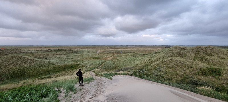
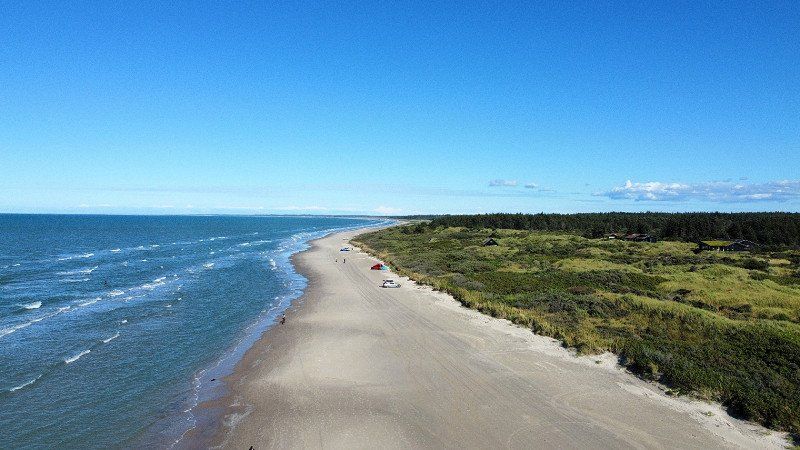
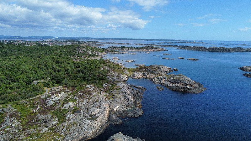
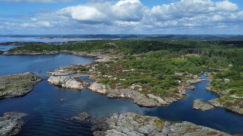
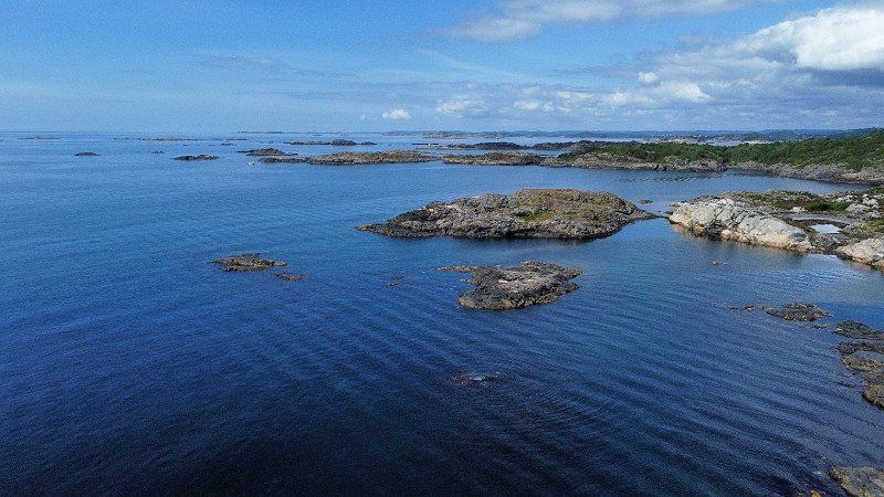
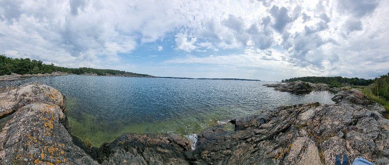
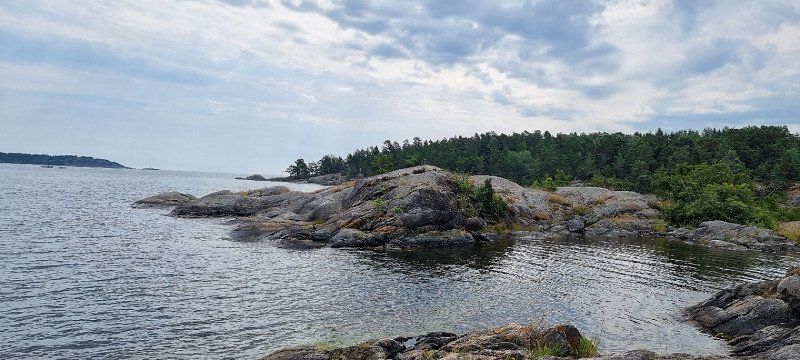
Flekkerøy, Norwegen
4th overnight stay
Location: Parking at Høyfjellet, Flekkerøy
right after the ferry (at 01.45 am) we drove here
it already had about five mobile homes here, which must have been here before
after us maybe two more arrived
if you're quiet, it shouldn't be a problem at this hour
in the morning we walked in the direction of Bestemorsmed
beautiful area here
Photos taken with the DJI Mini 2
Norwegen
58° 4' 19.9" N 7° 59' 36.8" E
58.0721875 7.9935625
• Head toward Vesterøya. Go for 18 m.
• Turn left onto Vesterøya. Go for 165 m.
• Continue on Vesterøya (3908). Go for 147 m.
• Turn slightly right onto Vesterøya (3908). Go for 262 m.
• Turn left onto Vesterøya (3908). Go for 192 m.
• Take the 4th exit from roundabout onto Flekkerøyveien (457). Go for 3.0 km.
• Continue on Krooddveien (457). Go for 3.6 km.
• Pass 3 roundabouts and continue on Vågsbygdveien (456). Go for 1.9 km.
• Take ramp. Go for 296 m.
• Take the 4th exit from roundabout. Go for 252 m.
• Continue on Vesterveien. Go for 427 m.
• Take the 2nd exit from roundabout onto Fidjebakken (E39). Go for 27.4 km.
• Take the exit. Go for 749 m.
• Take the 2nd exit from roundabout onto E39. Go for 180 m.
• Pass 3 roundabouts and continue on Kristiansandsveien (E39). Go for 6.0 km.
• Turn left onto 477 toward Sentrum. Go for 359 m.
• Continue on Marnaveien (477). Go for 180 m.
• Take the 2nd exit from roundabout onto Marnaveien (477). Go for 180 m.
• Take the 3rd exit from roundabout onto Marnaveien (477). Go for 162 m.
• Take the 3rd exit from roundabout onto Store Elvegate (477). Go for 175 m.
• Continue on Bryggegata (477). Go for 198 m.
• Take the 2nd exit from roundabout onto Bryggegata (477). Go for 237 m.
• Continue on Nygata (477). Go for 258 m.
• Turn left onto Fridtjof Nansens vei. Go for 500 m.
• Continue on Hollendergata. Go for 38 m.
• Turn slightly right. Go for 24 m.
• Arrive at your destination on the left.
☍
46,9 km
( 43 min.)
Day
Sjøsanden, Mandal, Norwegen
Sandy beach (Sjøsanden) near Mandal, Norway
great sandy beach / also called gold beach
when the sun shines, the sand under the water turns golden
you can also go in practically level for a very long time
TOP recommendation
Norwegen
58° 1' 15.3" N 7° 27' 13.6" E
58.0209125 7.4537656
• Head toward Hollendergata. Go for 24 m.
• Turn right onto Hollendergata. Go for 38 m.
• Turn left onto Hollendergata. Go for 61 m.
• Turn slightly right onto Fridtjof Nansens vei. Go for 52 m.
• Turn slightly left onto Fridtjof Nansens vei. Go for 1.3 km.
• Continue on Gustav Vigelands vei (477). Go for 647 m.
• Turn left onto Halseveien (474). Go for 440 m.
• Turn right onto Mandalsveien (E39) toward Flekkefjord. Go for 10.2 km.
• Take the 1st exit from roundabout onto Peder Claussøns vei (460) toward Lindesnes Fyr/Vigeland/Sveindal. Go for 491 m.
• Turn left onto Smibakken (460). Go for 225 m.
• Take the 3rd exit from roundabout onto Spangereidveien (460). Go for 15.6 km.
• Take the 2nd exit from roundabout onto Lindesnesveien (460). Go for 269 m.
• Take the 2nd exit from roundabout onto Lindesnesveien (460). Go for 2.7 km.
• Turn slightly left onto Lindesnesveien (460). Go for 5.2 km.
• Turn left onto 460. Go for 22 m.
• Continue on Lindesnesveien (460). Go for 2.0 km.
• Continue on 460. Go for 4 m.
• Continue on Lindesnesveien (460). Go for 1.0 km.
• Turn left. Go for 44 m.
• Arrive at your destination on the left.
☍
40,4 km
( 53 min.)
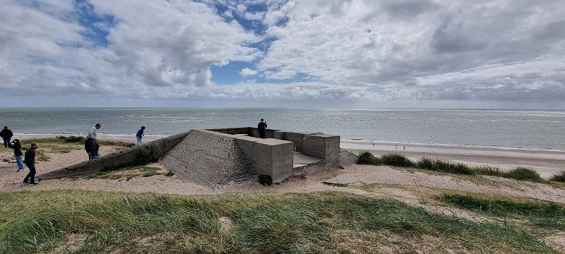
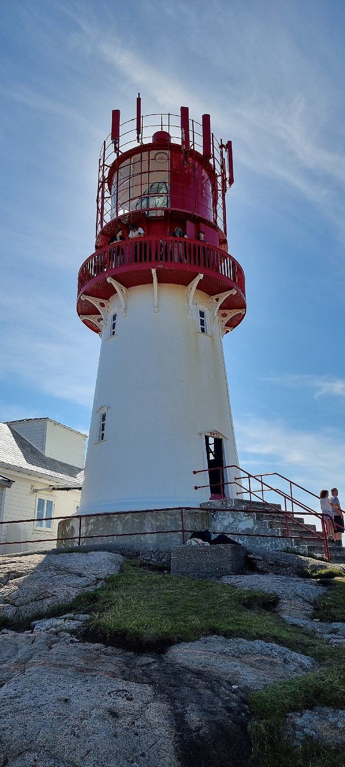
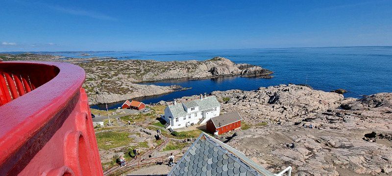
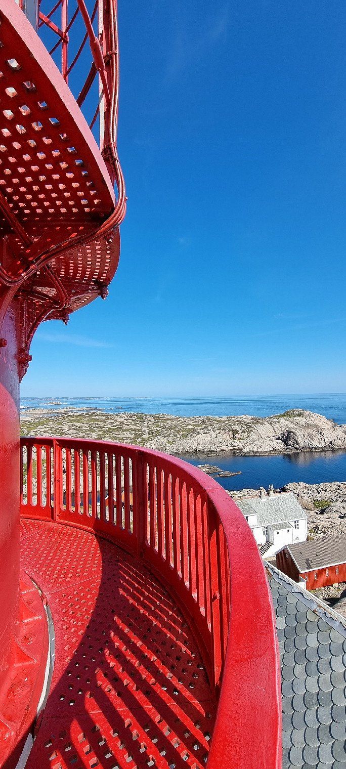
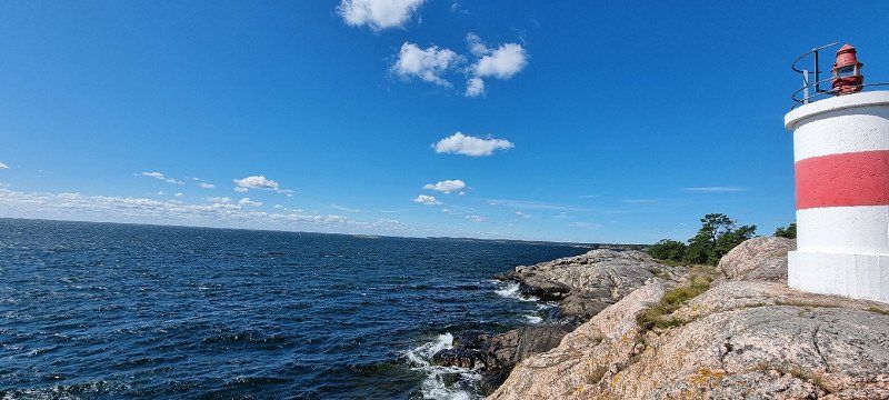
Lindesnes Fyr, Lindesnes, Norwegen
Lighthouse at Lindesnes
Gun battery + connecting trenches from WW2
a somewhat longer journey is compensated by the lighthouse (freely accessible) and the various trenches and facilities from WW2
there is also a museum and a small shop
Norwegen
57° 59' 6.2" N 7° 2' 58.4" E
57.9850625 7.0495625
• Head toward Lindesnesveien. Go for 44 m.
• Turn right onto Lindesnesveien (460). Go for 1.0 km.
• Continue on 460. Go for 4 m.
• Continue on Lindesnesveien (460). Go for 2.0 km.
• Continue on 460. Go for 22 m.
• Continue on Lindesnesveien (460). Go for 2.0 km.
• Turn slightly right onto Lindesnesveien (460). Go for 5.9 km.
• Take the 2nd exit from roundabout onto Lindesnesveien (460). Go for 259 m.
• Take the 2nd exit from roundabout onto Spangereidveien (460). Go for 277 m.
• Turn left onto Lindalsveien (4078). Go for 4.2 km.
• Continue on Jåsundveien (4078). Go for 2.3 km.
• Continue on 4078. Go for 4 m.
• Continue on Jåsundveien (4078). Go for 7.2 km.
• Turn right onto Rosnesveien (4078). Go for 1.2 km.
• Continue on Agnefestveien (4078). Go for 1.6 km.
• Turn left onto Alleen (4084). Go for 236 m.
• Turn right onto Grøndokktunet. Go for 133 m.
• Continue on Grøndokkmoen (464). Go for 933 m.
• Turn left onto Utsiktsveien (4102). Go for 795 m.
• Continue on 4102. Go for 1.4 km.
• Continue on Dragedalen (4091). Go for 9.1 km.
• Turn right toward E39. Go for 36 m.
• Turn left onto E39. Go for 21.1 km.
• Take ramp toward 44/Sokndal/Flekkefjord/Sentrum/Sykehus. Go for 277 m.
• Continue toward Austadveien/44. Go for 28 m.
• Take the 2nd exit from roundabout onto Austadveien (44). Go for 32.3 km.
• Arrive at 44. Your destination is on the left.
☍
94,4 km
(1 hrs. 49 min.)
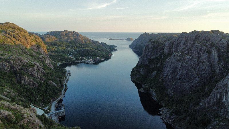
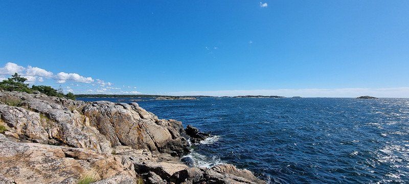
Jøssingfjord, Norwegen
5th overnight stay
Location: Parking above Jøssingfjord
we parked right in the parking lot for the viewpoint
there is a small kiosk here (open all day) a public toilet is open all day
Photos taken with the DJI Mini 2
Norwegen
58° 19' 50.5" N 6° 21' 5.2" E
58.3306875 6.3514375
• Head west on 44. Go for 5.4 km.
• Take the 2nd exit from roundabout onto Sokndalsveien (44). Go for 26.9 km.
• Take the 3rd exit from roundabout onto Bøckmans gate (44). Go for 373 m.
• Pass 4 roundabouts and continue on Jernbaneveien (44). Go for 979 m.
• Take the 3rd exit from roundabout onto Eigerøyveien (44). Go for 66 m.
• Take the 1st exit from roundabout onto Eigerøyveien (44). Go for 76 m.
• Take the 1st exit from roundabout onto Eigerøyveien (44). Go for 2.4 km.
• Turn right onto Bjerkreimsveien (4296). Go for 4.9 km.
• Continue on Tengesdalsvegen (4296). Go for 4.9 km.
• Continue on Apeland (4296). Go for 651 m.
• Continue on Tengesdalsvegen (4296). Go for 1.8 km.
• Turn left onto Bjerkreimsvegen (E39). Go for 29.9 km.
• Pass 3 roundabouts and continue on Sandnesveien (E39). Go for 27.0 km.
• Keep right onto Hundvågtunnelen (13). Go for 5.7 km.
• Enter the roundabout. Go for 66 m.
• Arrive at your destination on the left.
☍
111,0 km
(1 hrs. 34 min.)
Day
Ryfast-Tunnel / Ryfylke-Tunnel, Norwegen
is used for the correct route display
Ryfast tunnel system between Stavanger and Solbakk
Norwegen
59° 0' 11.9" N 5° 44' 17" E
59.0033125 5.7380625
• Follow the roundabout. Go for 76 m.
• Take the 3rd exit from roundabout onto Ryfylketunnelen (13). Go for 14.9 km.
• Take the 1st exit from roundabout onto Ryfylkevegen (13). Go for 115 m.
• Pass 3 roundabouts and continue on Ryfylkevegen (523). Go for 10.9 km.
• Turn left onto Preikestolvegen (4642). Go for 5.1 km.
• Turn slightly right onto Preikestolvegen. Go for 19 m.
• Turn right onto Preikestolvegen. Go for 11 m.
• Turn slightly left. Go for 15 m.
• Arrive at your destination on the left.
☍
31,1 km
( 30 min.)
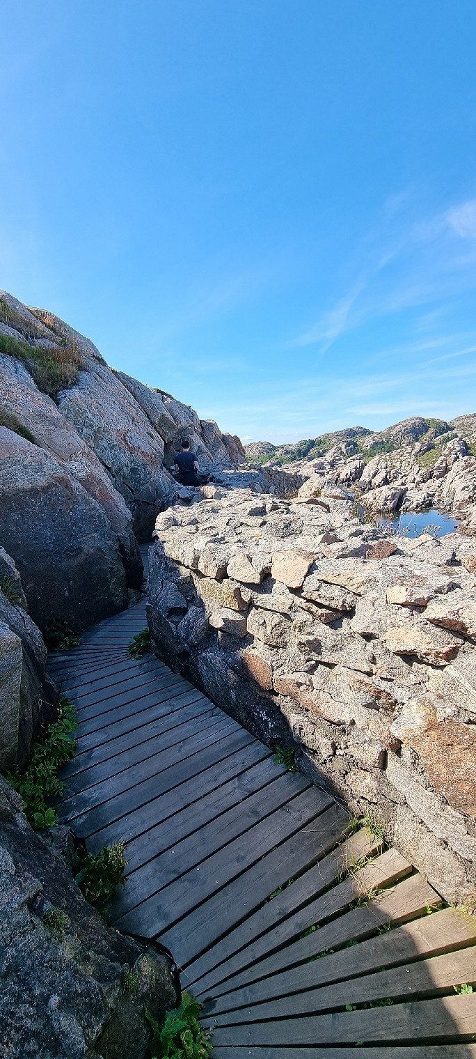
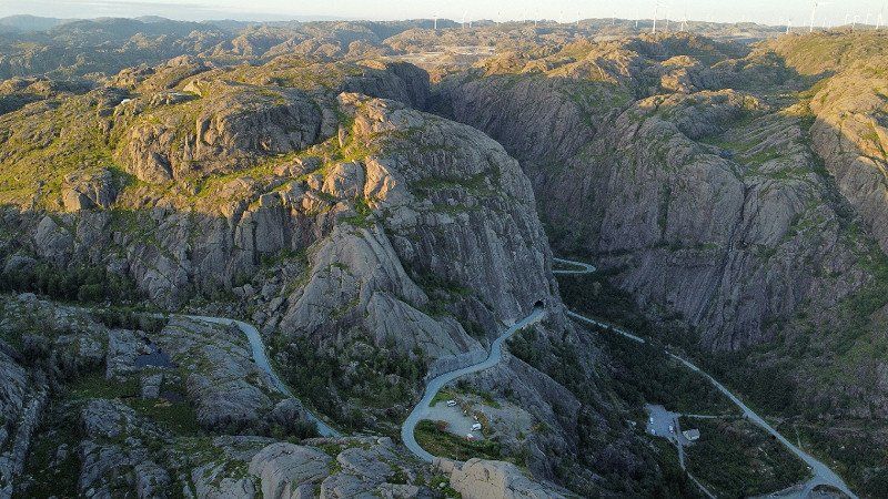
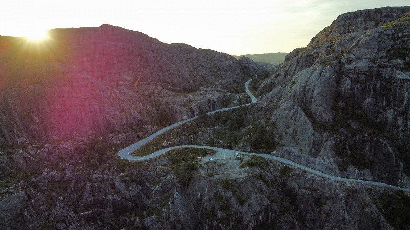
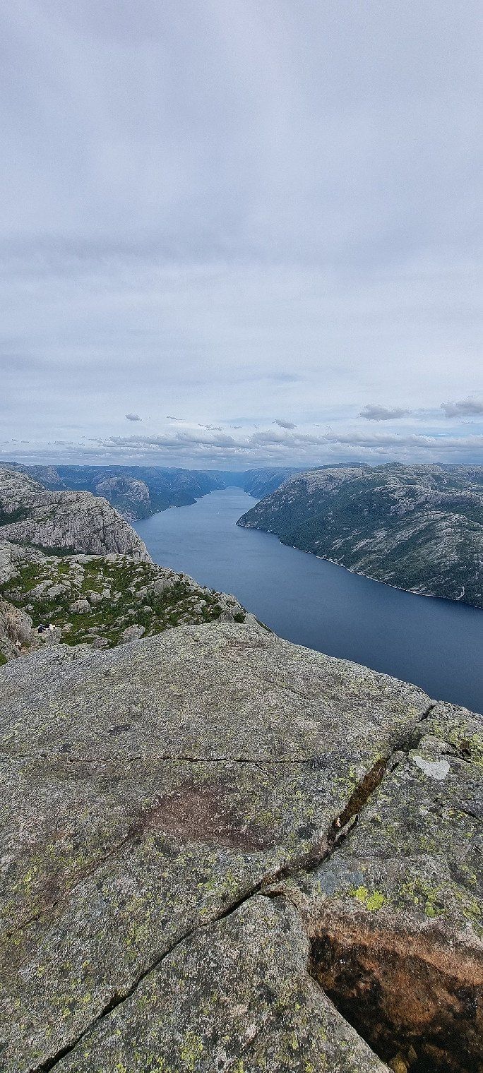
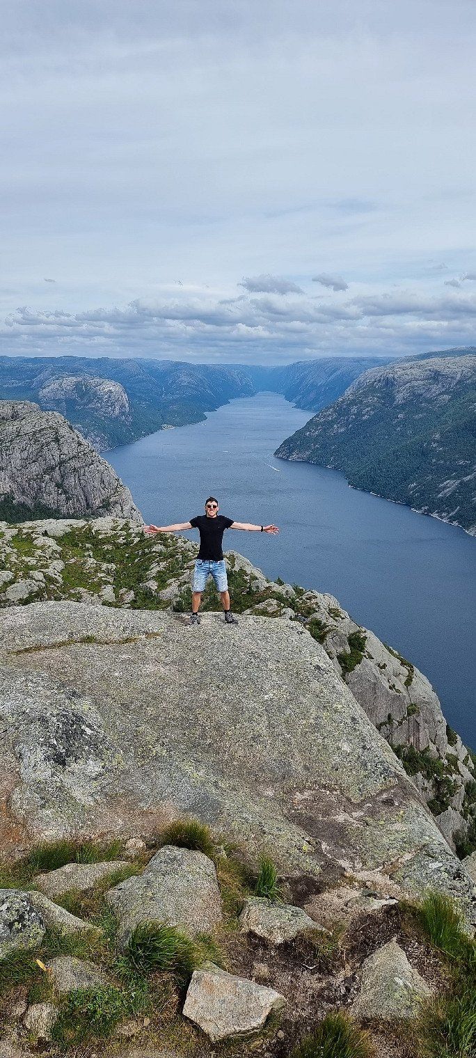
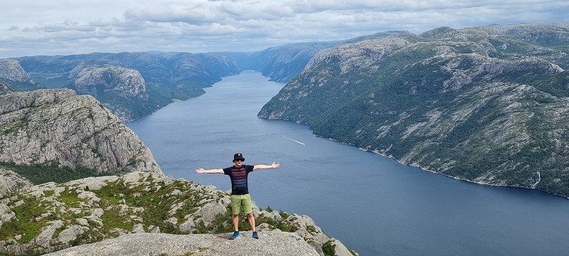
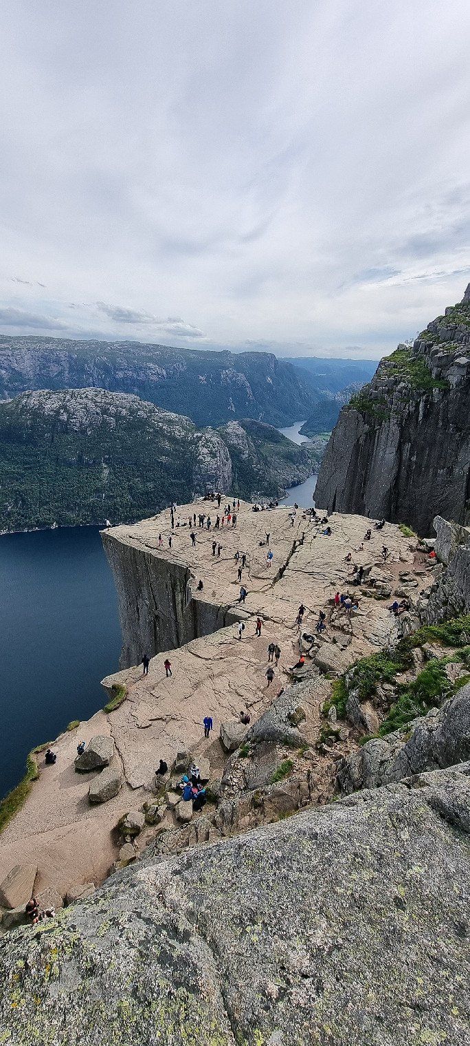
Preikestolen, Norwegen
worth a stop despite mass tourism!!!
we arrived at the parking lot at around 2 p.m
from the lower parking it is a leisurely hike up the Preikestolen (depending on the definition, leisurely :D)
Ascent: 3.8km, 330m up, approx. 1h 30min
Descent: 3.8km, 330m down, approx. 60min
Norwegen
58° 59' 30.1" N 6° 8' 15.7" E
58.9916875 6.1376875
• Head northwest. Go for 108 m.
• Turn left onto Preikestolvegen (4642). Go for 4.2 km.
• Turn left onto Preikestolvegen. Go for 64 m.
• Turn left onto Preikestolvegen. Go for 39 m.
• Arrive at Preikestolvegen. Your destination is on the left.
☍
4,4 km
( 6 min.)
Preikestolen Camping, Norwrgen
6th overnight stay
Location: Preikestolen Camping
well located campsite, a few minutes before the Preikestolen car park
as we used it, the campsite is often used for through traffic
for one night this place (free choice of seats) is completely sufficient
Norwegen
58° 59' 56.2" N 6° 5' 32.8" E
58.9989375 6.0924375
• Head east on Preikestolvegen. Go for 82 m.
• Turn left onto Preikestolvegen. Go for 113 m.
• Turn right onto Preikestolvegen. Go for 19 m.
• Turn left onto Preikestolvegen (4642). Go for 908 m.
• Turn right onto Ryfylkevegen (523). Go for 3.7 km.
• Pass 4 roundabouts and continue on Ryfylkevegen (13). Go for 10.8 km.
• Enter the roundabout. Go for 3 m.
• Arrive at your destination.
☍
15,6 km
( 17 min.)
Day
Tau, Norwegen
is used for the correct route display
Norwegen
59° 3' 53" N 5° 55' 21.6" E
59.0647125 5.9226719
• Follow the roundabout. Go for 3 m.
• Take the 1st exit from roundabout onto Ryfylkevegen (13). Go for 43.7 km.
• Take the 2nd exit from roundabout onto 13. Go for 215 m.
• Arrive at 13. Your destination is on the left.
☍
44,0 km
( 39 min.)
Hjelmeland, Norwegen
Crossing by ferry to Nesvik
the ferry runs every 30 minutes
depending on the rush and time you have to wait 30 minutes in the worst case
a reservation is not necessary
an invoice is sent via the license plate and holder - very conveniently
Norwegen
59° 14' 1.7" N 6° 9' 56.5" E
59.2338125 6.1656875
• Head northwest on 13. Go for 54 m.
• Take the Hjelmeland-Nesvik Ferry. Stay on for 3.1 km.
• Head northwest on Indre Ryfylkevegen (13). Go for 27 m.
• Arrive at Indre Ryfylkevegen (13). Your destination is on the left.
☍
3,2 km
( 34 min.)
Nesvik, Norwegen
Ferry Hjelmeland - Nesvik
there is only one deck for all cars/RVs
there are toilets below deck
you can remain seated for the journey of approx. 12 minutes
Norwegen
59° 15' 42.5" N 6° 9' 31.3" E
59.2618125 6.1586875
• Head toward Jøsnesvegen on Indre Ryfylkevegen (13). Go for 41.1 km.
• Arrive at Sandsvegen (13). Your destination is on the left.
☍
41,1 km
( 35 min.)
Sand, Norwegen
is used for the correct route display
Norwegen
59° 28' 33" N 6° 17' 17.3" E
59.4758375 6.2881406
• Head northeast on Suldalsvegen (13).
• Turn right onto Suldalsvegen (13). Go for 50.4 km.
• Turn left. Go for 18 m.
• Turn slightly right. Go for 23 m.
• Arrive at your destination on the left.
☍
50,4 km
( 43 min.)
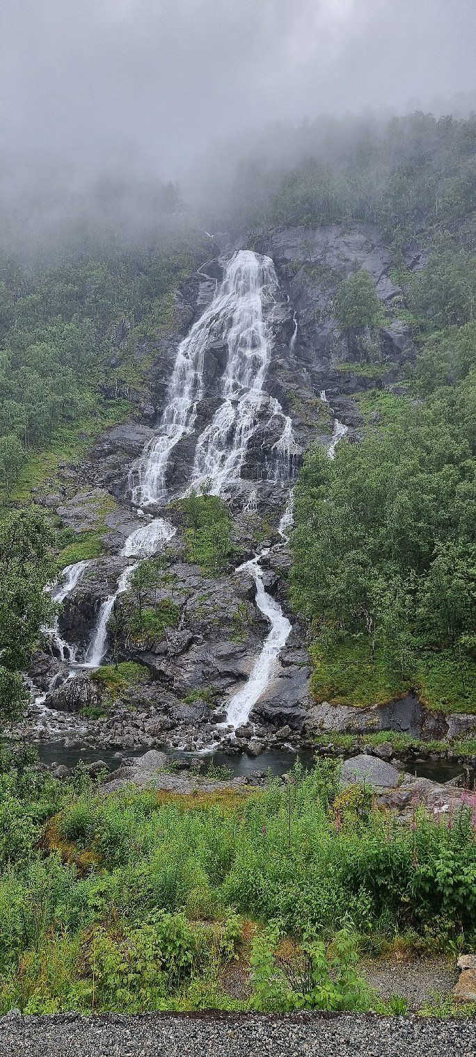
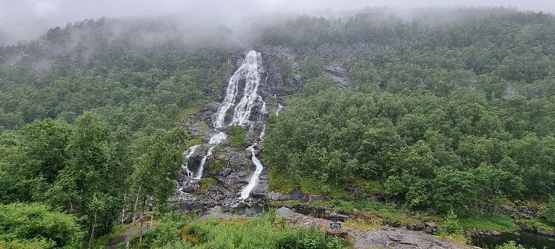
Flesefossen, Brattlandsdalen, Norwegen
Flesefossen waterfall
it can be parked directly on the street
A small service area is currently being built on the road side of the river
Norwegen
59° 41' 31" N 6° 45' 7.4" E
59.6919375 6.7520625
• Head northwest. Go for 53 m.
• Turn left onto Suldalsvegen (13). Go for 16.8 km.
• Turn left onto Håra (E134). Go for 20.0 km.
• Turn right onto 13 toward Brimnes/Odda/550/Utne/551/48/Rosendal. Go for 17.7 km.
• Pass 2 roundabouts and continue on Butunnelen (13). Go for 58.0 km.
• Take the 2nd exit from roundabout onto Vallaviktunnelen (13). Go for 30.3 km.
• Turn right onto 13 toward E16. Go for 874 m.
• Continue on Strandavegen (E16). Go for 542 m.
• Enter the roundabout. Go for 28 m.
• Arrive at your destination on the right.
☍
144,3 km
(2 hrs. 13 min.)
Vossevangen, Norwegen
is used for the correct route display
Norwegen
60° 38' 31.9" N 6° 26' 10" E
60.6421875 6.4361094
• Follow the roundabout. Go for 26 m.
• Take the 1st exit from roundabout onto Strandavegen (E16). Go for 1.1 km.
• Pass 4 roundabouts and continue on Vinjadalen (E16). Go for 22.8 km.
• Arrive at Oppheimsvegen (E16). Your destination is on the right.
☍
23,9 km
( 21 min.)
Oppheim, Norwegen
is used for the correct route display
Norwegen
60° 47' 35.6" N 6° 34' 38.3" E
60.7932125 6.5772969
• Head northeast on Oppheimsvegen (E16). Go for 12.7 km.
• Arrive at E16. Your destination is on the right.
☍
12,7 km
( 10 min.)
Nærøydalselvi, Norwegen
7. Overnight stay
Location: Rest area at Nærøydalselvi
the rest area is right next to the E16
We rarely heard or noticed anything from the traffic at night
Unfortunately, early in the morning (about 9 a.m.) a truck cleaning the toilet disturbed us (very loud)
Norwegen
60° 50' 37.7" N 6° 43' 27.5" E
60.8438125 6.7243125
• Head toward Nærøydalen on E16. Go for 26.5 km.
• Turn right onto Flåmsdalsvegen (5624). Go for 189 m.
• Continue on Flåmsdalsvegen. Go for 131 m.
• Turn left onto Nedre Fretheim. Go for 636 m.
• Turn left onto Stasjonsvegen. Go for 134 m.
• Arrive at Stasjonsvegen. Your destination is on the right.
☍
27,6 km
( 22 min.)
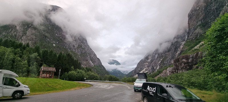
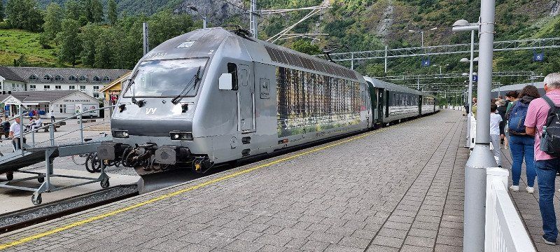
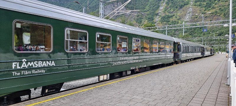
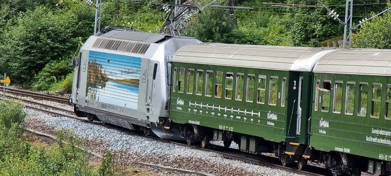
Day
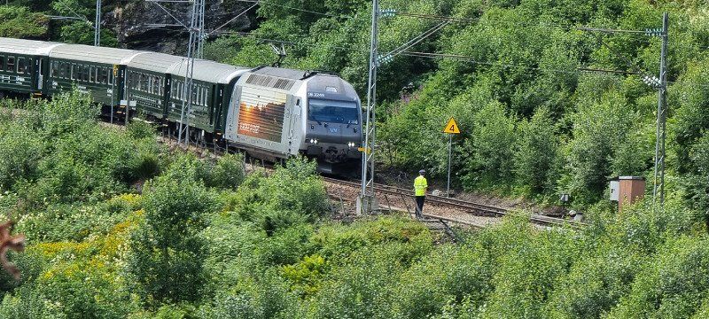
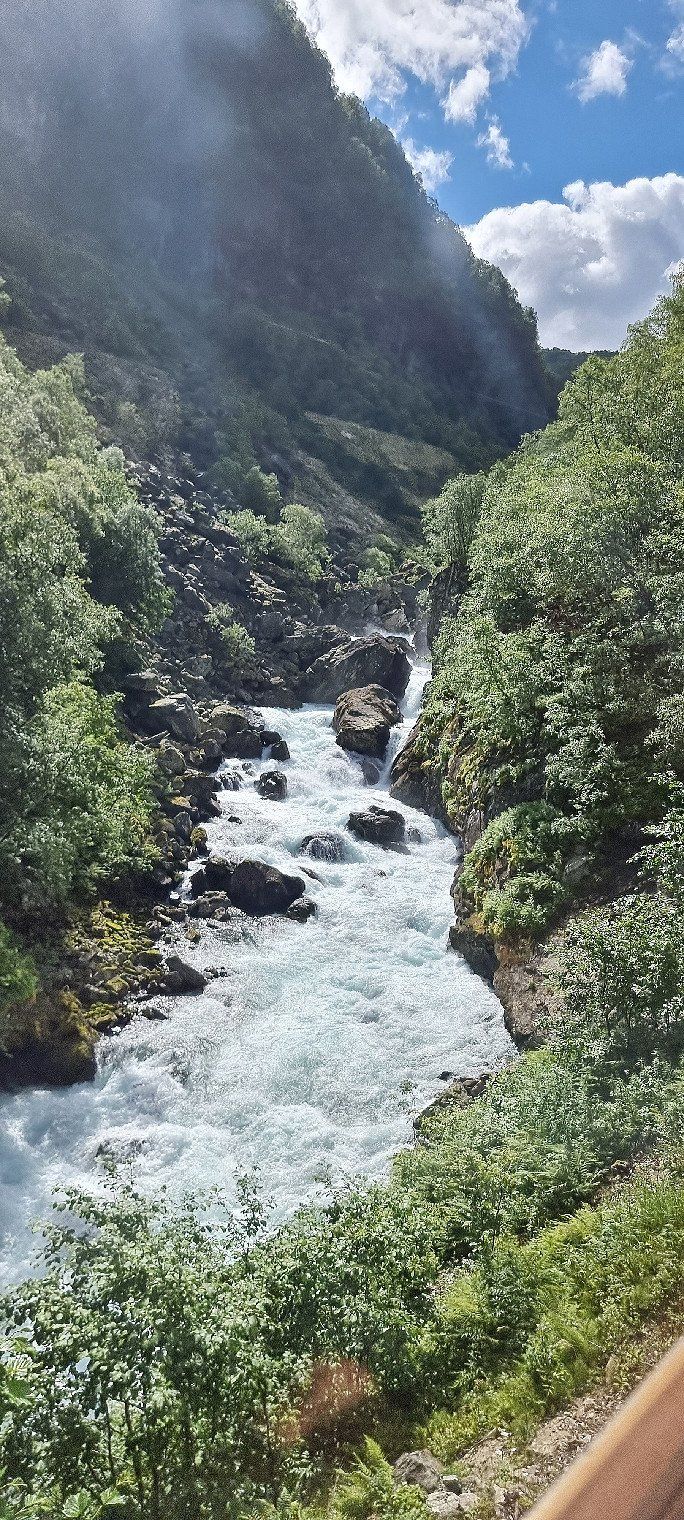
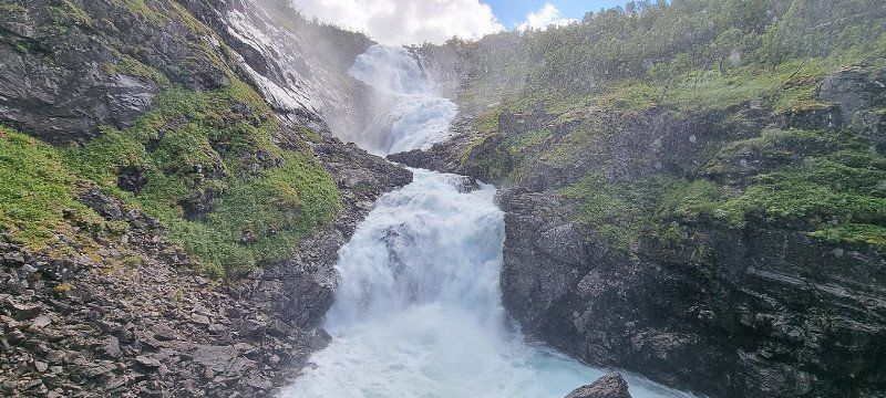
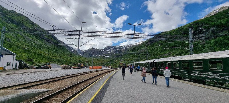
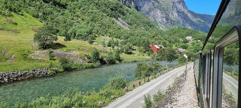
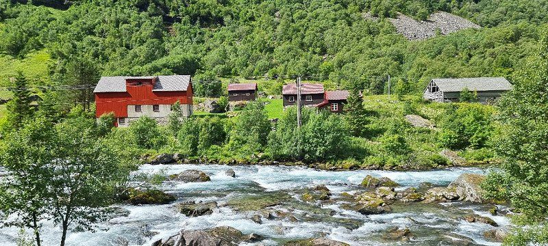
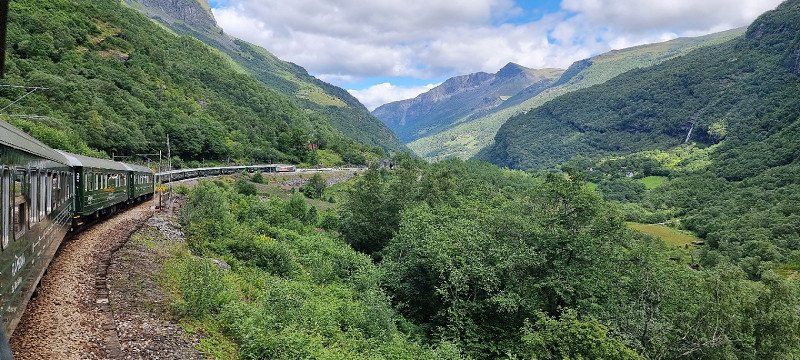
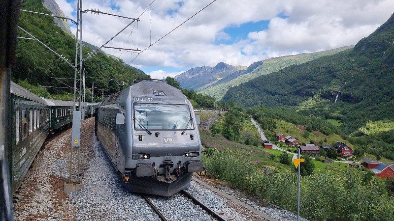
Flåm, Norwegen
Flamsbana
Tourist train route from Flåm to Myrdal
20km length one way
60 minutes up / 60 minutes down
from 2 m above sea level up to 866 m above sea level
definitely very scenic
Next time we would book differently
we had booked directly with a return trip (12min break in Myrdal above)
it would definitely be nicer to combine it with a hike or bike ride down
Norwegen
60° 51' 46.6" N 7° 6' 52.4" E
60.8629375 7.1145625
• Head south on Stasjonsvegen. Go for 59 m.
• Turn slightly left onto Stasjonsvegen. Go for 38 m.
• Turn right onto Stasjonsvegen. Go for 37 m.
• Turn right onto Nedre Fretheim. Go for 636 m.
• Turn right onto Flåmsdalsvegen. Go for 320 m.
• Turn right onto E16. Go for 9.1 km.
• Pass 2 roundabouts and continue on E16. Go for 53.3 km.
• Take the 1st exit from roundabout onto 52 toward 7/Oslo/Gol. Go for 40.0 km.
• Arrive at Hemsedalsvegen (52). Your destination is on the right.
☍
103,5 km
(1 hrs. 24 min.)
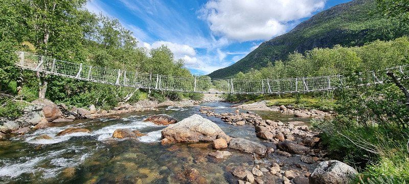
Hemsedal, Norwegen
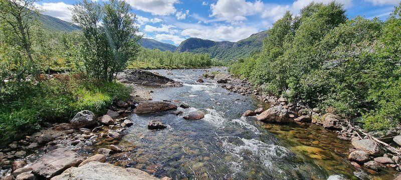
Pedestrian suspension bridge
directly at the road 52 (Borlaug - Gol)
Norwegen
60° 52' 10.4" N 8° 25' 32.9" E
60.8695625 8.4258125
• Head east on Hemsedalsvegen (52). Go for 39.3 km.
• Take the 2nd exit from roundabout onto 7 toward Oslo/Hønefoss. Go for 1.5 km.
• Pass 3 roundabouts and continue on 7. Go for 74.5 km.
• Take ramp toward Drammen/35/Hokksund/Noresund/Norefjell. Go for 218 m.
• Take the 1st exit from roundabout onto 280. Go for 15.3 km.
• Take the 2nd exit from roundabout onto Krøderfjordveien (280). Go for 6.5 km.
• Continue on 288. Go for 161 m.
• Take the 1st exit from roundabout onto Krøderfjordveien (288). Go for 5.5 km.
• Turn right. Go for 36 m.
• Arrive at your destination on the right.
☍
143,0 km
(2 hrs. 1 min.)
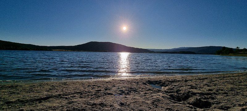
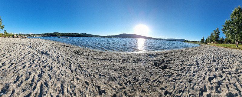
Krøderen, Norwegen
8th overnight stay
Location: Parking at Krøderen
After looking for a suitable parking lot along the lakes for a long time, we almost wanted to give up and drove off to a parking lot
to our astonishment there was already a mobile home a little below the road and we joined it
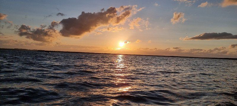
very nice sunset and a small beach at the lake
Norwegen
60° 7' 45.5" N 9° 46' 38.8" E
60.1293125 9.7774375
• Head toward Krøderfjordveien. Go for 36 m.
• Turn left onto Krøderfjordveien (280). Go for 5.4 km.
• Take the 1st exit from roundabout onto 288. Go for 14.4 km.
• Enter the roundabout. Go for 16 m.
• Arrive at your destination.
☍
19,8 km
( 16 min.)
Day
Sokna, Norwegen
is used for the correct route display
Norwegen
60° 14' 30.8" N 9° 55' 5.3" E
60.2418875 9.9181406
• Follow the roundabout. Go for 31 m.
• Take the 2nd exit from roundabout onto Hallingdalsveien (7). Go for 20.4 km.
• Take the 1st exit from roundabout onto E16 toward Oslo/Hokksund/35. Go for 5.9 km.
• Take the 1st exit from roundabout onto Osloveien (E16). Go for 20.3 km.
• Take ramp onto Skarveien (285) toward Drammen. Go for 1.3 km.
• Take the 1st exit from roundabout onto Lierveien (285). Go for 20.8 km.
• Take the 3rd exit from roundabout onto Kirkelina (282). Go for 1.9 km.
• Take the 1st exit from roundabout onto Kirkelina (282). Go for 1.1 km.
• Take left ramp onto E18 toward Oslo. Go for 29.1 km.
• Take ramp toward Ring 1/Sentrum V. Go for 319 m.
• Take the 2nd exit from roundabout onto Munkedamsveien (162) toward E18/E6. Go for 864 m.
• Take the 3rd exit from roundabout onto Henrik Ibsens gate. Go for 594 m.
• Take the 1st exit from roundabout onto Parkveien. Go for 155 m.
• Turn right. Go for 239 m.
• Arrive at your destination on the right.
☍
103,0 km
(1 hrs. 31 min.)
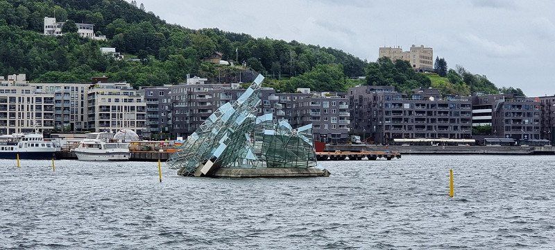
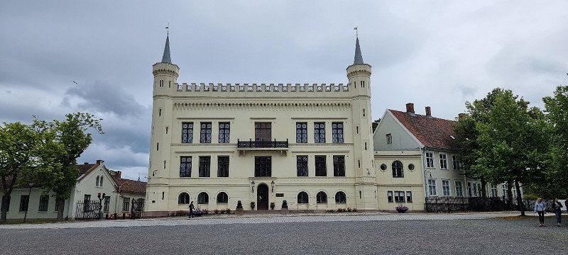
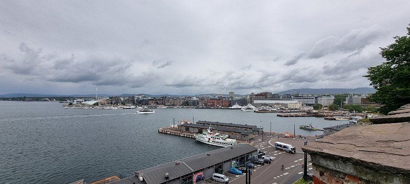
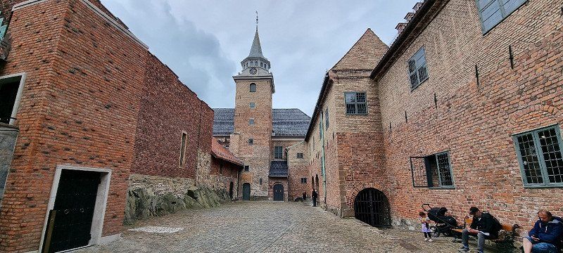
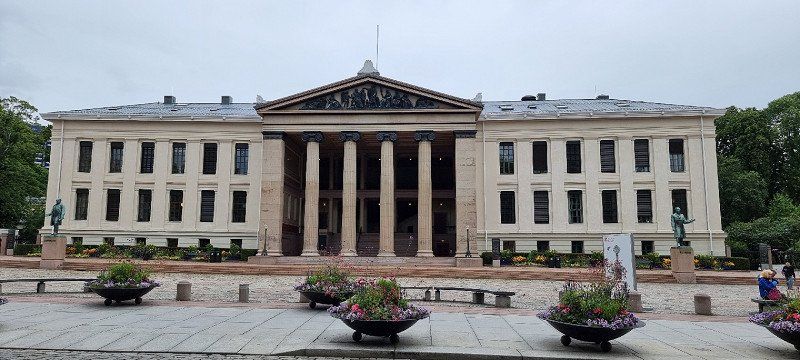
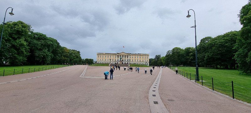
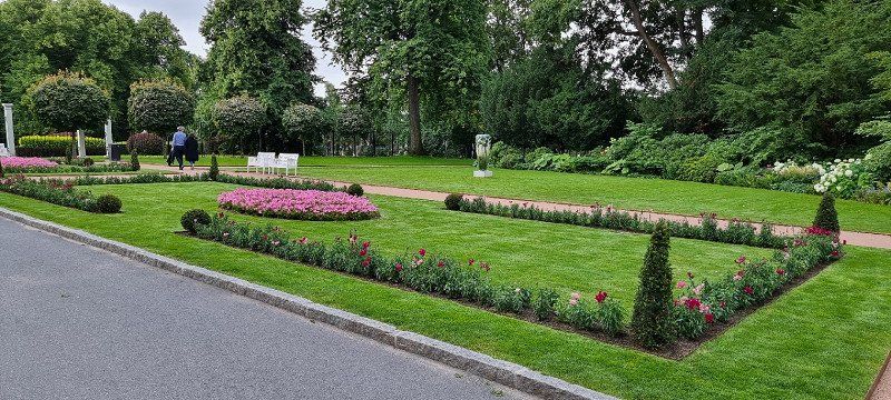
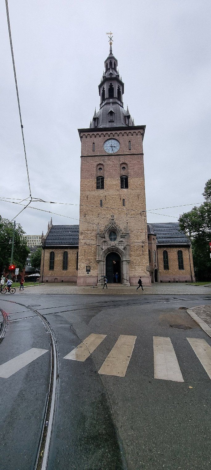
Oslo City, Norwegen
Sightseeing in the city
including the Royal Palace, Akershus Fortress, Cathedral Church, Botanical Garden and much more
we have previously parked the mobile home at the Sjølyst parking space
We then took the bus (bus stop right in front of the entrance) to Sentralstasjon in the city
Of course, you can also cycle comfortably into town from the parking space
Norwegen
59° 55' 1.4" N 10° 43' 38.8" E
59.9170625 10.7274375
• Head toward Colbjørnsens gate. Go for 239 m.
• Turn left onto Parkveien. Go for 149 m.
• Take the 1st exit from roundabout onto Henrik Ibsens gate. Go for 271 m.
• Take the 2nd exit from roundabout onto Bygdøy allé. Go for 1.4 km.
• Keep left onto Bygdøy allé toward Bygdøy/E18. Go for 493 m.
• Take the 2nd exit from roundabout onto Sjølystveien (E18) toward Drammen. Go for 542 m.
• Take ramp toward Ring 2/Majorstuen. Go for 183 m.
• Turn right onto Drammensveien. Go for 18 m.
• Take the 5th exit from roundabout onto Sjølystveien toward Sjølyst Marina. Go for 160 m.
• Take the 1st exit from roundabout. Go for 76 m.
• Turn left. Go for 162 m.
• Arrive at your destination on the left.
☍
3,7 km
( 8 min.)
Olso Sjølyst, Norwegen
9th overnight stay
Location: BestMarin campsite, Oslo Sjølyst
Simple parking space on a large asphalt area (probably boat parking space in winter)
The electricity is available, only the WLAN didn't work at all
the toilets and showers were borderline (are on a separate trailer)
for one night in Oslo it's just fine, nothing more
Norwegen
59° 55' 9.1" N 10° 40' 37.4" E
59.9191875 10.6770625
• Head northwest. Go for 162 m.
• Turn right toward Drammensveien. Go for 50 m.
• Take the 2nd exit from roundabout onto Drammensveien toward Ring 2/Majorstuen. Go for 95 m.
• Take the 2nd exit from roundabout onto Drammensveien (161) toward Majorstuen. Go for 228 m.
• Take the 3rd exit from roundabout onto Hoffsveien toward Holmenkollen. Go for 657 m.
• Take the 3rd exit from roundabout onto Hoffsveien. Go for 1.1 km.
• Turn left onto Monolitveien. Go for 122 m.
• Turn right onto Ullernchausséen. Go for 97 m.
• Continue on Viggo Hansteens vei. Go for 91 m.
• Turn left onto Sørkedalsveien (168) toward Røa/Holmenkollen. Go for 171 m.
• Turn right onto Holmenkollveien. Go for 3.1 km.
• Turn left onto Holmenkollveien. Go for 120 m.
• Turn slightly right onto Holmenkollveien. Go for 453 m.
• Continue on Holmenkollveien. Go for 257 m.
• Turn slightly right onto Holmenkollveien. Go for 127 m.
• Continue on Holmenkollveien. Go for 94 m.
• Turn left onto Kongeveien. Go for 30 m.
• Turn left. Go for 56 m.
• Turn right. Go for 35 m.
• Turn slightly left. Go for 34 m.
• Turn right. Go for 13 m.
• Arrive at your destination on the right.
☍
7,1 km
( 15 min.)
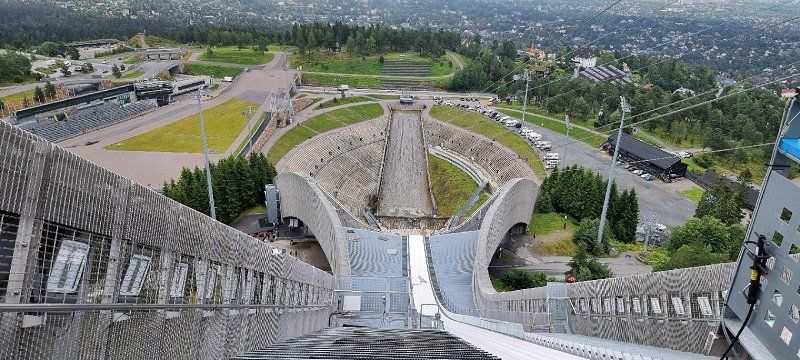
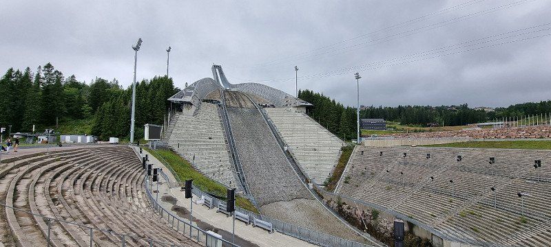
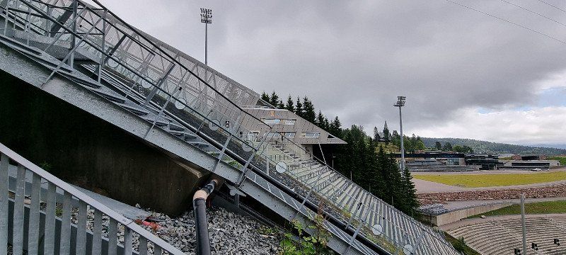
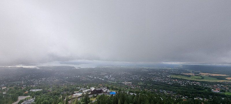
Oslo Holmenkollen, Norwegen
Visit to the ski jumping facility at Holmenkollen
You have to pay to enter the museum and the ski jumping tower - but it's definitely worth it!
you can learn a lot about Norwegian history in ski jumping and cross-country skiing
if you haven't had enough thrills, you can slide over the jump with the zipline
Norwegen
59° 57' 43.9" N 10° 40' 0.1" E
59.9621875 10.6666875
• Head west. Go for 13 m.
• Turn right toward Kongeveien. Go for 27 m.
• Turn right onto Kongeveien. Go for 149 m.
• Turn right onto Holmenkollveien. Go for 1.1 km.
• Turn left onto Ankerveien. Go for 737 m.
• Continue on Frognerseterveien. Go for 934 m.
• Continue on Risalléen. Go for 304 m.
• Turn left onto Slemdalsveien. Go for 1.1 km.
• Turn left and take ramp onto Ring 3 (150) toward Sinsen. Go for 5.3 km.
• Keep left onto Ring 3 (150) toward Ryen/163/E6. Go for 2.9 km.
• Keep left onto Hjalmar Brantings vei (E6) toward Gøteborg/E18/Stokholm/Ryen. Go for 3.9 km.
• Keep left onto E6 toward Gøteborg/E18/Stokholm. Go for 18.3 km.
• Take exit 21 toward 154/Ski onto E18. Go for 6.9 km.
• Take the 2nd exit from roundabout onto E18 toward Askim. Go for 57.1 km.
• Turn right onto Storgata (1316) toward Ørje. Go for 110 m.
• Turn right onto Engebret Soots vei (1316). Go for 176 m.
• Turn left onto Damholtveien (1316). Go for 29 m.
• Arrive at Damholtveien (1316). Your destination is on the left.
☍
99,1 km
(1 hrs. 18 min.)
Day
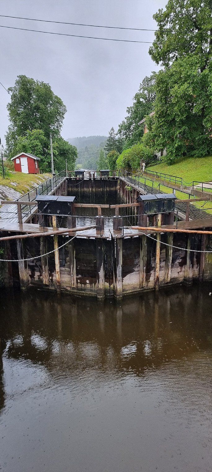
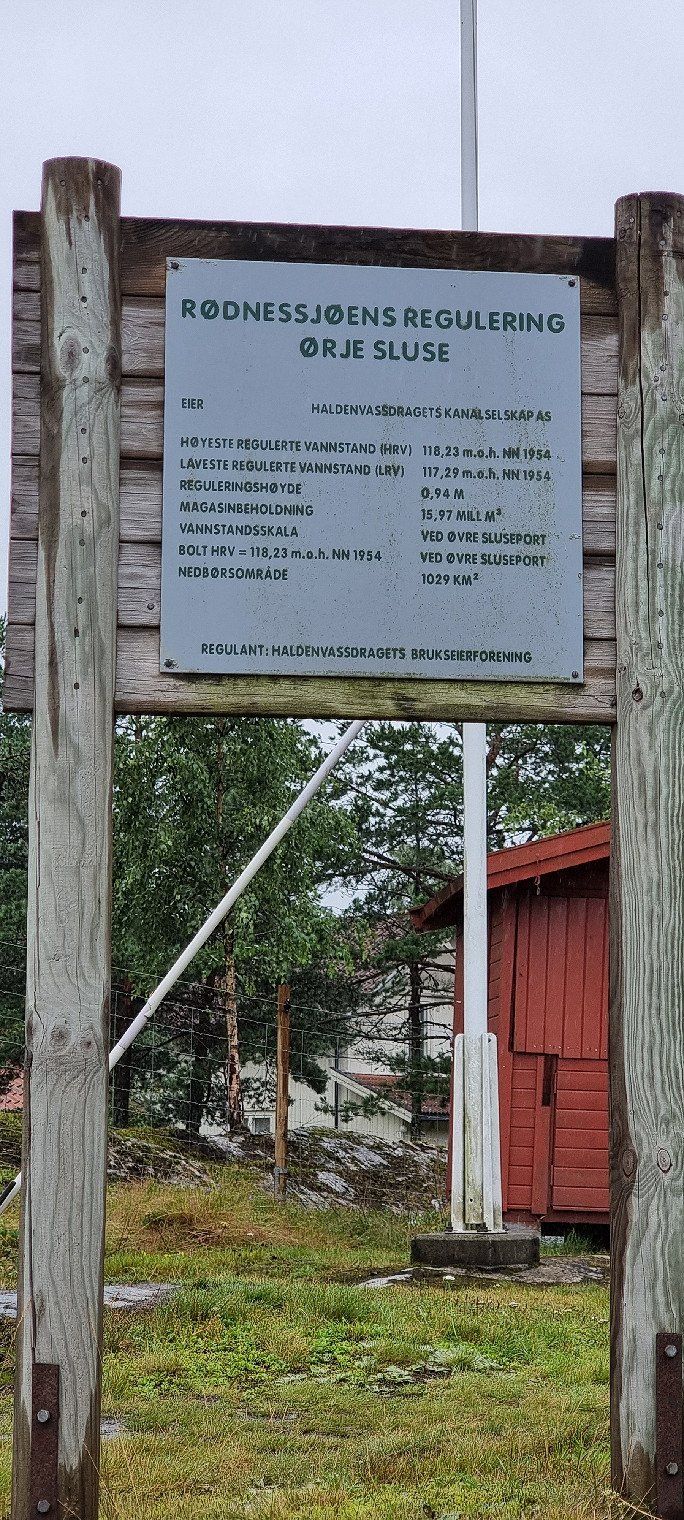
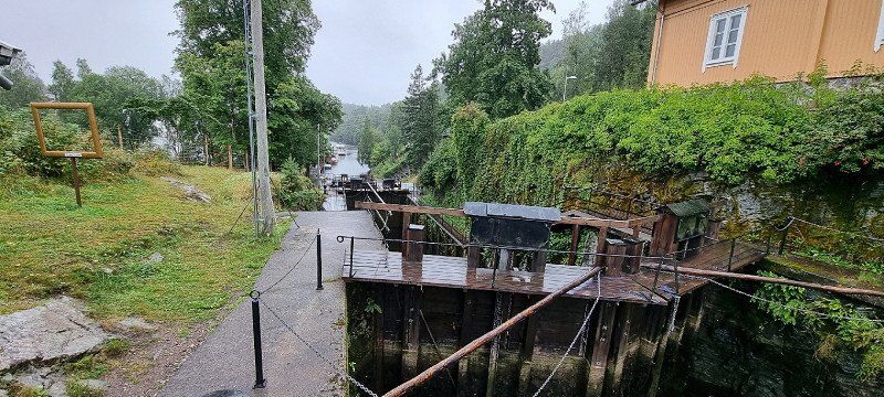
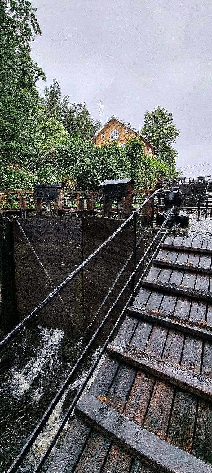
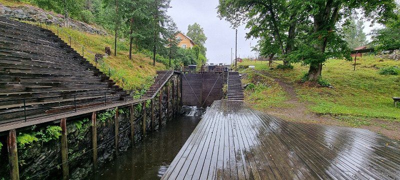
Ørje, Norwegen
Ørje locks
From Rødenessjøen you can get to Øymarksjøen with the help of four locks
Norwegen
59° 28' 57.7" N 11° 39' 3.8" E
59.4826875 11.6510625
• Head toward Vestre Rødenesveien on Damholtveien (1316). Go for 29 m.
• Turn right onto Engebret Soots vei (1316). Go for 176 m.
• Turn left onto Storgata (1316). Go for 62 m.
• Turn right onto Osloveien (E18). Go for 6.4 km.
• Continue on E18. Go for 104 km.
• Pass 2 roundabouts and continue on E18. Go for 85.0 km.
• Take the 2nd exit from roundabout onto Örebrovägen (E18) toward Stockholm/Nora. Go for 1.3 km.
• Take the 1st exit from roundabout onto Örebrovägen (E18) toward Stockholm/Nora. Go for 39.2 km.
• Take the exit onto E18/E20 (Bergslagsdiagonalen). Go for 2.5 km.
• Take exit 111 toward Centrum/Sjukhus/Aspholmen/Birsta/Gustavsvik. Go for 828 m.
• Take the 2nd exit from roundabout onto Adolfsbergsvägen (E20.5). Go for 117 m.
• Take the 3rd exit from roundabout onto Södra vägen toward Gustavsvik/Aspholmen. Go for 1.1 km.
• Take the 1st exit from roundabout toward Gustavsvik. Go for 227 m.
• Turn right onto Gustavsviksvägen. Go for 502 m.
• Turn sharp right onto Sommarrovägen. Go for 195 m.
• Turn slightly left. Go for 46 m.
• Arrive at your destination on the right.
☍
241,3 km
(2 hrs. 47 min.)
Örebro, Schweden
10th overnight stay
Location: Camping Gustavsvik, Örebro
very large campsite with TOP rating
the sanitary area is absolutely fine
many activities are offered for the children
it is therefore rather a bit louder here than on a smaller campsite
Schweden
59° 15' 19.6" N 15° 11' 22.4" E
59.2554375 15.1895625
• Head toward Sommarrovägen. Go for 46 m.
• Turn left onto Sommarrovägen. Go for 51 m.
• Turn right onto Sommarrovägen. Go for 163 m.
• Turn right toward Gustavsviksvägen. Go for 78 m.
• Turn left onto Gustavsviksvägen. Go for 227 m.
• Turn left toward Södra vägen. Go for 211 m.
• Take the 2nd exit from roundabout onto Södra vägen toward E18/E20/50/Aspholmen. Go for 1.0 km.
• Take the 2nd exit from roundabout onto Västhagagatan toward E18/E20. Go for 384 m.
• Take ramp onto E18/E20 (Bergslagsdiagonalen) toward Stockholm/50/Falun. Go for 47.2 km.
• Take exit 121 toward Stockholm/Eskilstuna/Arboga Ö onto E20. Go for 4.5 km.
• Take the 3rd exit from roundabout onto E20 toward Stockholm/Eskilstuna/Kungsör. Go for 10.9 km.
• Continue on E20 toward 56. Go for 101 km.
• Take the left exit toward Stockholm onto E4/E20. Go for 26.4 km.
• Take exit 154 toward Södermalm/Liljeholmen onto Södertäljevägen. Go for 3.1 km.
• Continue on Liljeholmsbron. Go for 358 m.
• Turn right onto Hornsgatan toward Skanstull/Medborgarplatsen/Södersjukhuset. Go for 2.3 km.
• Continue on Slussbron. Go for 95 m.
• Arrive at Slussbron. Your destination is on the right.
☍
198,5 km
(2 hrs. 8 min.)
Day
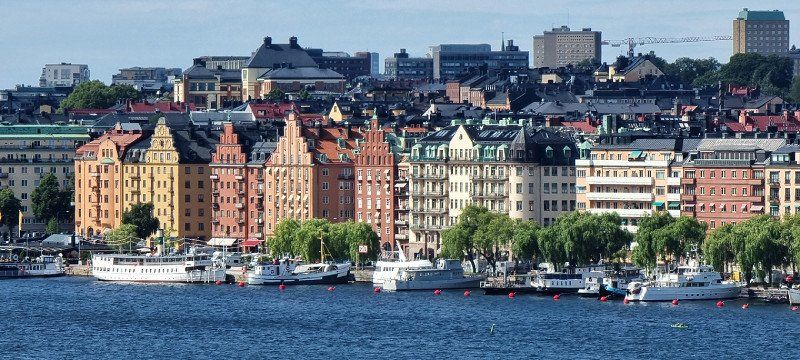
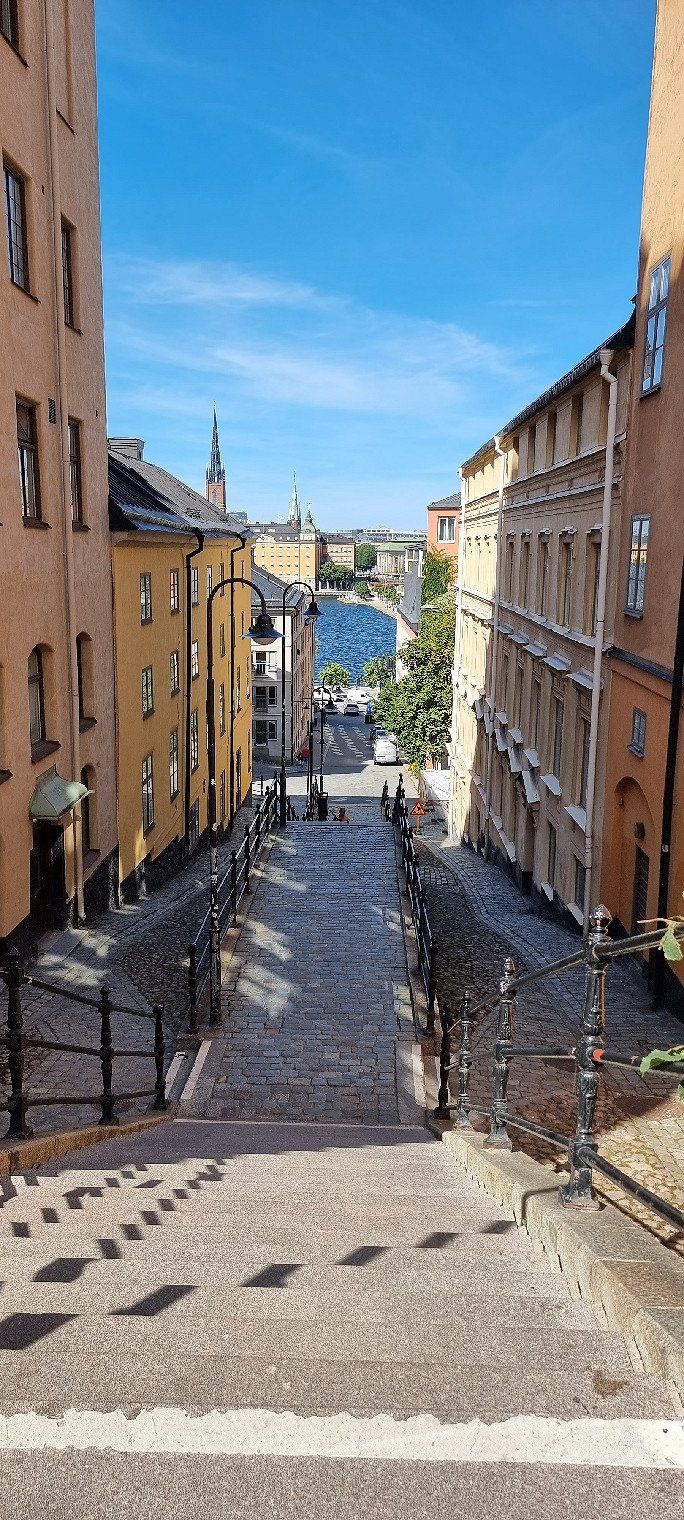
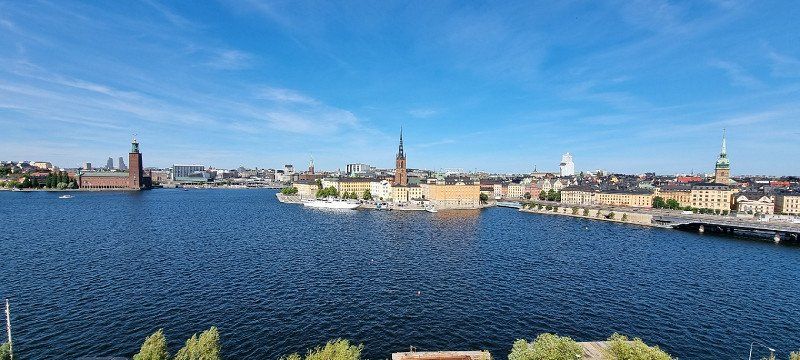
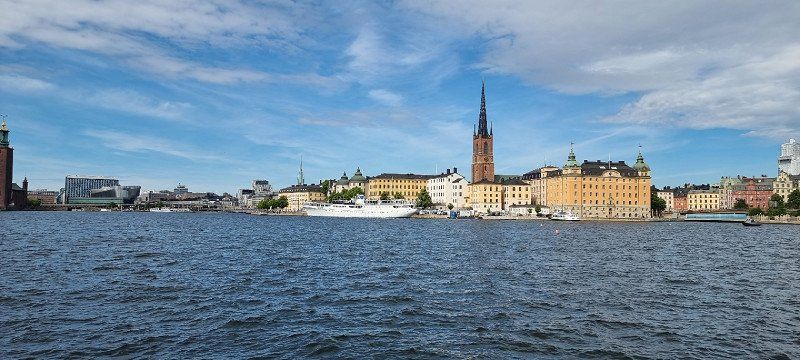
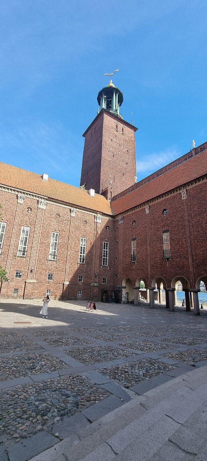
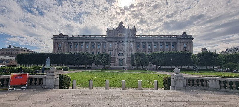
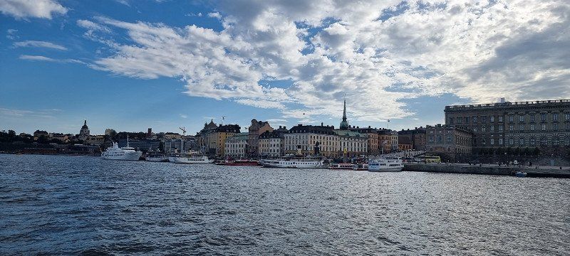
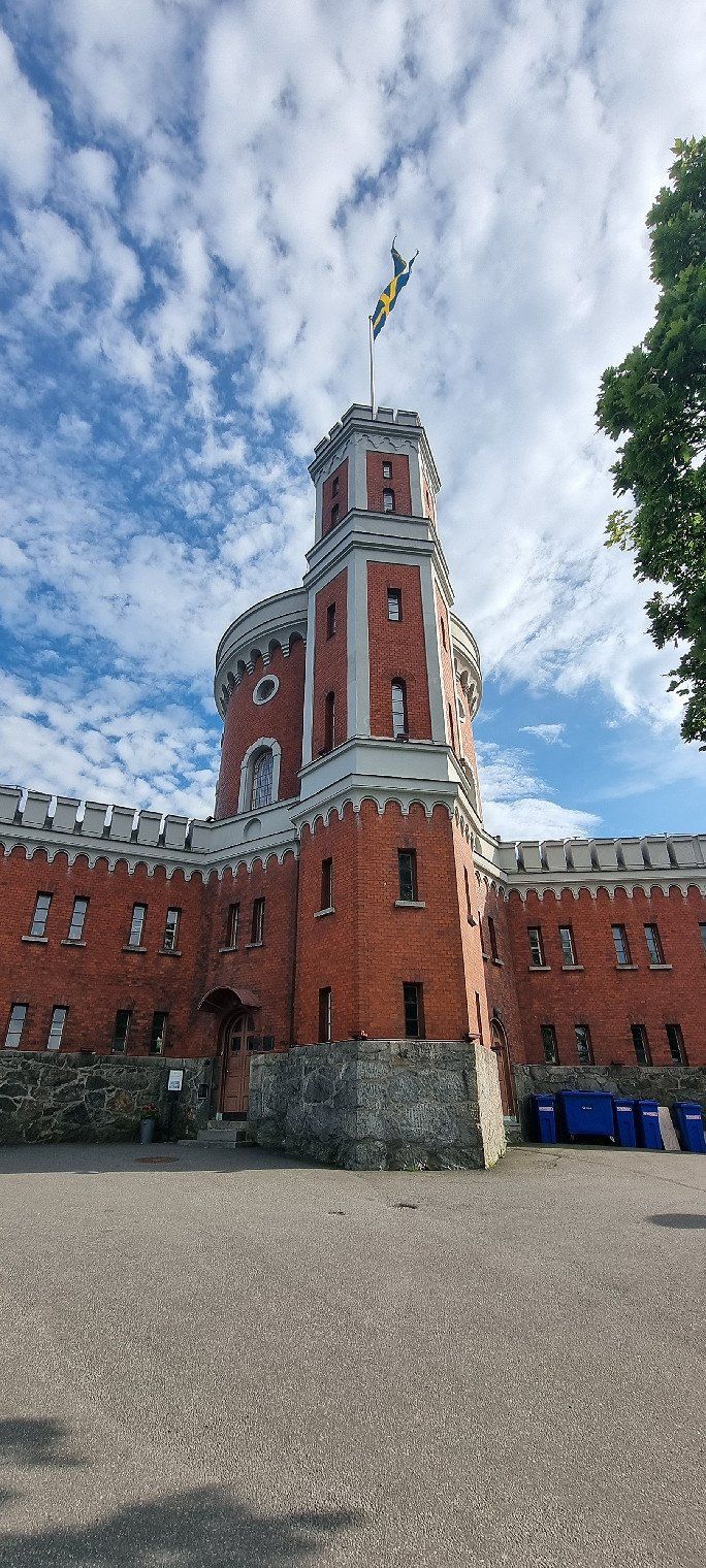
Stockholm City, Schweden
Sightseeing in the city
including government building, resting place of Swedish kings, house of knights, royal house, parliament building and much more
We have previously parked the mobile home at the First Camp City-Stockholm parking space
we then took the bus (bus stop at the car park in front) in about 30 minutes to Slussen in the city
Schweden
59° 19' 14.7" N 18° 4' 25.2" E
59.3207625 18.0736719
• Head toward Skeppsbron on Slussbron. Go for 114 m.
• Continue on Skeppsbron. Go for 113 m.
• Make a U-Turn onto Skeppsbron. Go for 112 m.
• Continue on Slussbron. Go for 195 m.
• Continue on Hornsgatan. Go for 231 m.
• Turn left and take ramp onto Söderledstunneln (E4.25) toward 73/Nynäshamn/Medborgarplatsen. Go for 6.4 km.
• Take the exit toward Tyresö/Sköndal onto 229 (Örbyleden). Go for 5.4 km.
• Take the exit toward Nacka/Älta/Lindalen/Flaten. Go for 329 m.
• Turn right onto Flatenvägen toward Flaten. Go for 351 m.
• Turn left onto Flatenvägen. Go for 113 m.
• Arrive at Flatenvägen.
☍
13,4 km
( 14 min.)
Stockholm Altä, Schweden
11th overnight stay
Location: Pitch, First Camp City-Stockholm
before the actual campsite comes, there are very nice camper pitches here
bookable with or without electricity
the very neat sanitary facilities are included
the WiFi is just enough from the campsite
Flaten Skogsväg 30, 128 30, Skarpnäck, Schweden
59° 14' 53.5" N 18° 9' 41.9" E
59.2481880 18.1616340
• Head east on Flatenvägen. Go for 55 m.
• Turn right onto Flatenvägen. Go for 418 m.
• Continue on Ältavägen (260). Go for 154 m.
• Turn right and take ramp onto 229 (Tyresövägen) toward Stockholm. Go for 5.4 km.
• Take ramp onto 73 (Nynäsvägen) toward Nynäshamn. Go for 49.3 km.
• Continue on Järnvägsgatan. Go for 597 m.
• Continue on Strandvägen. Go for 195 m.
• Continue on Hamnviksvägen. Go for 2.7 km.
• Turn right onto Hamnviksvägen. Go for 70 m.
• Turn slightly left onto Hamnviksvägen. Go for 86 m.
• Arrive at Hamnviksvägen. Your destination is on the right.
☍
58,9 km
( 46 min.)
Day
Nynäshamn, Schweden
very beautiful landscape with many small islands
it has many good swimming spots along the rocks by the water, even a small beach has it
getting in and out was sometimes a little challenging
the cooling has done well in any case
Photos taken with the DJI Mini 2
Schweden
58° 52' 36.7" N 17° 55' 36.7" E
58.8768625 17.9268594
• Head southwest on Hamnviksvägen. Go for 235 m.
• Turn left onto Hamnviksvägen. Go for 2.7 km.
• Continue on Strandvägen. Go for 195 m.
• Continue on Järnvägsgatan. Go for 597 m.
• Continue on Nynäsvägen (73). Go for 9.6 km.
• Take the exit toward Södertälje/Spångbro/Ösmo. Go for 358 m.
• Turn left onto Sittesta (225) toward Södertälje/Spångbro/Ösmo. Go for 7.6 km.
• Turn right onto Porthus (225) toward Södertälje/Spångbro. Go for 21.9 km.
• Pass 2 roundabouts and continue on 225. Go for 9.7 km.
• Continue on 225 toward E4S/E20S/Centrum/Sjukhus. Go for 319 m.
• Turn left and take ramp onto E4/E20 toward Helsingborg/Göteborg. Go for 2.3 km.
• Continue on E4 (Trafikplats Saltskog östra) toward Helsingborg/Nyköping. Go for 67.1 km.
• Take exit 132 toward Oxelösund/Nyköping V. Go for 353 m.
• Take the 1st exit from roundabout onto Västerleden (53). Go for 732 m.
• Pass 3 roundabouts and continue on Oxelösundsvägen (53). Go for 12.9 km.
• Turn right onto Femörevägen. Go for 50 m.
• Turn right onto Femörevägen. Go for 45 m.
• Turn slightly left onto Femörevägen. Go for 844 m.
• Turn slightly right onto Fiskehamnsvägen. Go for 712 m.
• Turn right onto Söderviksvägen. Go for 666 m.
• Continue on Söder-Femöre. Go for 158 m.
• Continue on Söder-Femöre. Go for 327 m.
• Arrive at Söder-Femöre. Your destination is on the left.
☍
139,3 km
(1 hrs. 50 min.)
Oxelösund, Schweden
12th overnight stay
Location: Parking at Oxelösund
a large parking lot - there were only three motorhomes there overnight with us
the place is very popular with joggers / cyclists
early in the morning, accordingly, a few cars had already arrived
in the morning we walked to the cannon fortress from the cold war and to the small lighthouse and took some photos
Schweden
58° 39' 11.5" N 17° 6' 27.3" E
58.6531875 17.1075781
• Head west on Söder-Femöre. Go for 485 m.
• Continue on Söderviksvägen. Go for 666 m.
• Turn left onto Fiskehamnsvägen. Go for 712 m.
• Turn slightly left onto Femörevägen. Go for 889 m.
• Turn left onto Femörevägen. Go for 50 m.
• Turn left onto 53. Go for 11.9 km.
• Take the 2nd exit from roundabout onto Oxelösundsvägen (53). Go for 510 m.
• Take the 2nd exit from roundabout onto Västerleden (53). Go for 408 m.
• Take the 2nd exit from roundabout onto Västerleden (53). Go for 773 m.
• Take the 3rd exit from roundabout onto E4 toward Helsingborg. Go for 53.1 km.
• Keep right onto Trafikplats Norrköping norra toward Norrköping N C/55/Ingelsta/56. Go for 1.0 km.
• Continue toward 55/56. Go for 215 m.
• Continue on Stockholmsvägen toward 55/56. Go for 662 m.
• Continue on E4.8 (Stockholmsvägen). Go for 1.2 km.
• Take the 2nd exit from Ingelstarondellen roundabout onto Stockholmsvägen (E4.8) toward Centrum. Go for 273 m.
• Take the 3rd exit from Sandbyhovsrondellen roundabout onto Ståthögavägen (E4.8) toward Centrum. Go for 1.1 km.
• Pass 3 roundabouts and continue on Söderköpingsvägen (E22). Go for 6.6 km.
• Keep left onto Söderköpingsvägen (E22) toward Kalmar. Go for 10.6 km.
• Continue on Erik Dahlbergsgatan (E22) toward 210. Go for 110 km.
• Turn right toward Hjorted/Kristdala. Go for 3.7 km.
• Continue on Falsterbo. Go for 1.3 km.
• Continue on Falsterbo gård. Go for 1.9 km.
• Continue on Falsterbo Rosenvik. Go for 1.6 km.
• Continue on Falsterbo Strömsfors. Go for 1.3 km.
• Continue on Falsterbovägen. Go for 594 m.
• Turn right onto Bankvägen. Go for 21 m.
• Continue on Ankarsrumsvägen. Go for 20 m.
• Turn left onto Totebovägen. Go for 1.4 km.
• Continue on Hjorted Rosenlid. Go for 1.5 km.
• Continue on Möckelhult Skogshaga. Go for 3.5 km.
• Turn left toward Blixtorp. Go for 1.9 km.
• Continue on Blixtorp. Go for 838 m.
• Continue toward Össebo. Go for 792 m.
• Continue on Össebo. Go for 769 m.
• Turn right onto Össebo. Go for 508 m.
• Turn right onto Össebo. Go for 384 m.
• Arrive at Össebo. Your destination is on the left.
☍
223,3 km
(2 hrs. 41 min.)
Day
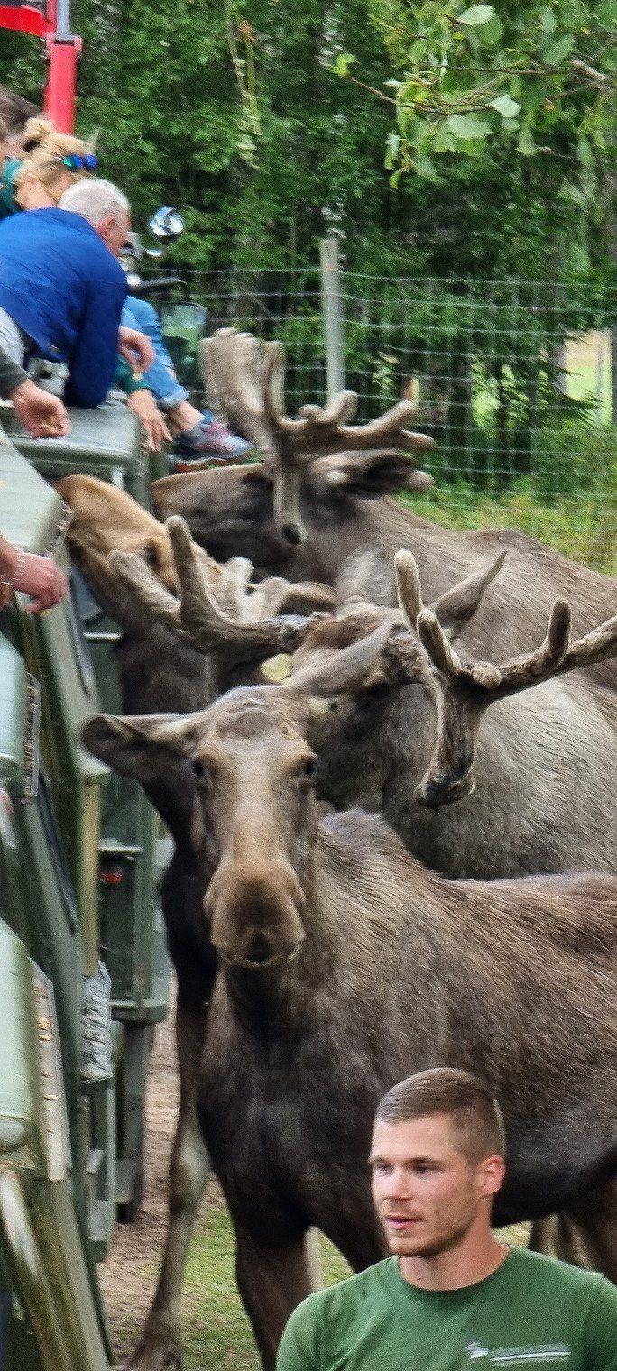
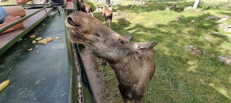
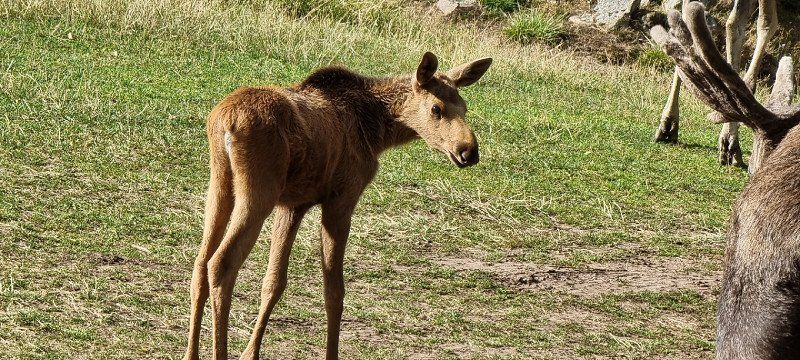
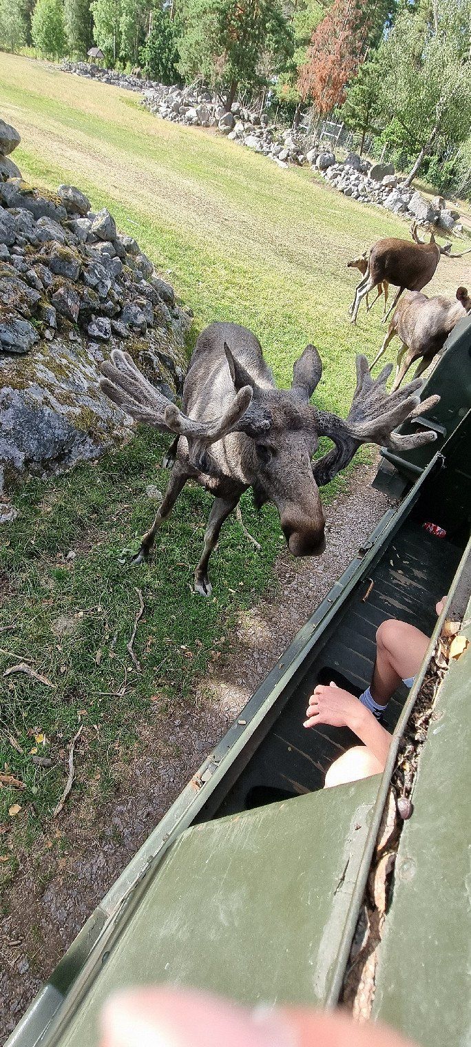
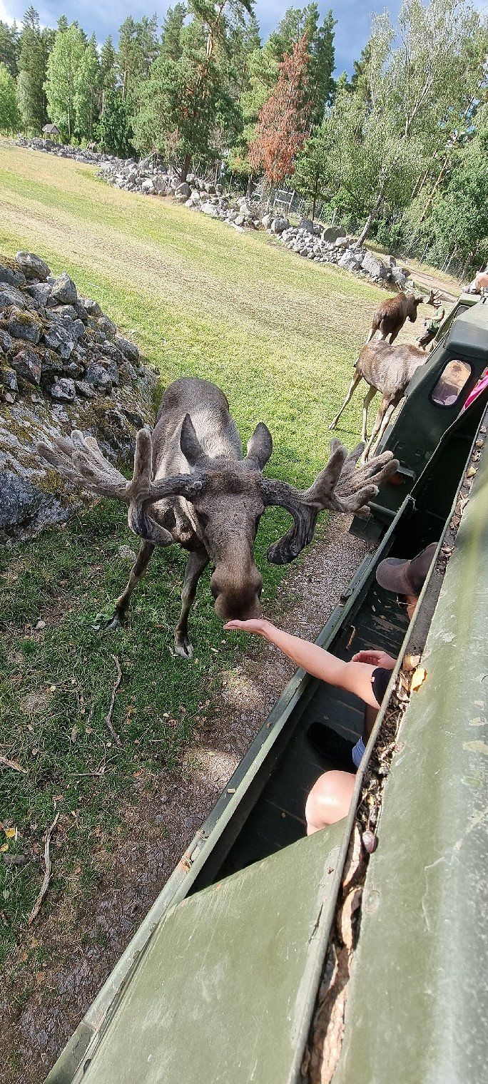
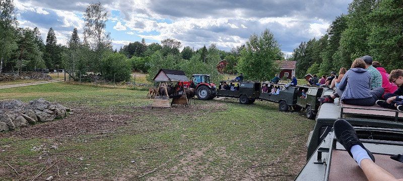
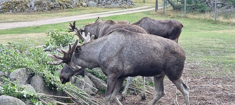
Virum Älgpark, Össebo, Schweden
a moose safari - a great experience!
you can choose whether you want to sit in or on the trailer
the entire trailer train (nine trailers) is pulled by a tractor
Potatoes are then distributed on the way, with which one can feed the moose
you can either hand feed or try the "moose kiss" (hold the potato in your mouth)
it was absolutely brilliant
the tour lasts about 45 minutes
Schweden
57° 35' 37.7" N 16° 11' 30.1" E
57.5938125 16.1916875
• Head south on Össebo. Go for 384 m.
• Turn left onto Össebo. Go for 508 m.
• Turn right onto Össebo. Go for 919 m.
• Turn right onto Tuna-Falla. Go for 4.4 km.
• Continue on Tuna. Go for 640 m.
• Turn left onto Tuna. Go for 4.0 km.
• Continue on Väderums gård. Go for 2.1 km.
• Continue on Flohult. Go for 1.7 km.
• Continue on Tuna-Mantebo. Go for 1.1 km.
• Continue toward Molid. Go for 132 m.
• Continue on Molid. Go for 1.8 km.
• Continue on Syserum Solhäll. Go for 312 m.
• Continue on Syserum Nynäs. Go for 812 m.
• Continue on Ishult. Go for 619 m.
• Turn right onto Ishult. Go for 341 m.
• Continue on Ishult Lidhem. Go for 336 m.
• Continue on Ishult Rosenlid. Go for 116 m.
• Continue on Ishult. Go for 148 m.
• Continue on Ishult Affären. Go for 67 m.
• Continue on Ishult. Go for 2.3 km.
• Continue on Ishult Grönlid. Go for 1.8 km.
• Continue on Grönlid Grönmossen. Go for 501 m.
• Continue on Grönlid Dalhem. Go for 763 m.
• Continue on Krokstorp Sandmon. Go for 327 m.
• Continue on Krokstorp Blommedal. Go for 859 m.
• Continue on Krokstorp Johannesberg. Go for 126 m.
• Continue toward Krokstorp Sans Sousi. Go for 47 m.
• Continue toward Krokstorp Sandshult. Go for 42 m.
• Continue on Krokstorp Lönnåsen. Go for 153 m.
• Continue on Krokstorp. Go for 345 m.
• Continue on Krokstorp Sjösätra. Go for 679 m.
• Continue on Krokstorp. Go for 297 m.
• Continue on Krokstorp Betanien. Go for 435 m.
• Continue on Blomsterhult Hällerum. Go for 593 m.
• Continue on Blomsterhult Rosendal. Go for 582 m.
• Continue on Blomsterhult. Go for 655 m.
• Continue on Blomsterhult Alsborg. Go for 972 m.
• Continue on Blomsterhult Rosenhult. Go for 662 m.
• Continue on Skälsebo. Go for 50 m.
• Continue on Snarås Holmsjömåla. Go for 173 m.
• Continue on Hälsingsö Affären. Go for 47 m.
• Continue on Hälsingsö. Go for 262 m.
• Continue toward Hälsingsö Alphyddan. Go for 60 m.
• Continue on Hälsingsö Alphyddan. Go for 135 m.
• Continue on Snarås. Go for 585 m.
• Continue on Snarås Ekhyddan. Go for 1.2 km.
• Continue on Nygård Solbacken. Go for 643 m.
• Turn right onto Nygård (E22). Go for 9.6 km.
• Turn left toward Dragskär/Virbo. Go for 146 m.
• Continue on Virkvarn Snuggan. Go for 737 m.
• Continue toward Virbo skolan. Go for 881 m.
• Continue on Virbo skolan. Go for 410 m.
• Continue on Virbo. Go for 2.9 km.
• Continue on Dragskär. Go for 294 m.
• Continue on Dragskär Draget. Go for 1.0 km.
• Continue on Dragskär. Go for 378 m.
• Continue on Dragskär Eken. Go for 121 m.
• Arrive at Dragskär Eken. Your destination is on the left.
☍
52,1 km
(1 hrs. )
Dragskär, Schweden
13th overnight stay
Location: Parking at Dragskär
absolute insider tip!!!
there is a normal parking lot here
Camping is even publicly posted here (only during the night) and tolerated
there were very few people here
the two public toilets were unfortunately full to the brim - as it looks like they are not emptied regularly :(
the rocks behind are also a dream for swimming!
Schweden
57° 18' 39.8" N 16° 34' 0.1" E
57.3110625 16.5666875
• Head toward Dragskär on Dragskär Eken. Go for 499 m.
• Continue on Dragskär Draget. Go for 1.0 km.
• Continue on Dragskär. Go for 1.7 km.
• Continue on Virbo. Go for 1.5 km.
• Continue on Virbo skolan. Go for 1.3 km.
• Continue on Virkvarn Snuggan. Go for 873 m.
• Turn left onto E22. Go for 160 km.
• Take ramp onto Österleden (28/122) toward Karlskrona Ö C/Vetlanda/Växjö. Go for 685 m.
• Take the 2nd exit from roundabout onto Österleden (28) toward Gdynia/Centrum. Go for 941 m.
• Continue on Österleden (28) toward Marieberg/Kungsmarken/Gullberna. Go for 5.6 km.
• Turn right onto Dockegatan. Go for 74 m.
• Continue on Björkholmskajen. Go for 531 m.
• Continue on Tjurkövägen. Go for 168 m.
• Continue on Hässlövägen. Go for 69 m.
• Take the 2nd exit from roundabout onto Ramsövägen. Go for 85 m.
• Continue on Strandvägen. Go for 319 m.
• Continue on Dragsövägen. Go for 403 m.
• Turn slightly right onto Dragsövägen. Go for 409 m.
• Arrive at Dragsövägen. Your destination is on the right.
☍
176,0 km
(2 hrs. 8 min.)
Day
Dragsö Camping Karlskrona, Schweden
14th overnight stay
Location: Dragsö Camping Karlskrona
very nice campsite on the entire peninsula
the approach takes place through the entire small town and is great
for shower (30 SEK for 3min) and washing machine (30 SEK for 70min) you have to pay something small
the sanitary facilities are a bit older, but always very clean
Electricity and wifi ok
Schweden
56° 10' 23.5" N 15° 34' 3.2" E
56.1731875 15.5675625
• Head south on Dragsövägen. Go for 812 m.
• Continue on Strandvägen. Go for 319 m.
• Continue on Ramsövägen. Go for 55 m.
• Take the 3rd exit from roundabout onto Hässlövägen. Go for 94 m.
• Continue on Tjurkövägen. Go for 168 m.
• Continue on Björkholmskajen. Go for 531 m.
• Continue on Dockegatan. Go for 74 m.
• Turn left onto Skeppsgossegatan. Go for 3.7 km.
• Take ramp onto Sunnavägen (E22) toward Ronneby. Go for 1.4 km.
• Take the 2nd exit from roundabout onto Ronnebyvägen (E22). Go for 2.2 km.
• Take ramp onto E22. Go for 8.2 km.
• Pass 2 roundabouts and continue on E22. Go for 85.3 km.
• Take the exit. Go for 224 m.
• Take the 3rd exit from roundabout. Go for 143 m.
• Take the 1st exit from roundabout. Go for 109 m.
• Turn left onto Nymövägen. Go for 2.7 km.
• Turn right onto Möllehusvägen. Go for 2.7 km.
• Turn left onto Hallingavägen. Go for 3.6 km.
• Turn left onto Åhusvägen (118) toward Åhus. Go for 6.5 km.
• Take the 2nd exit from roundabout onto Yngsjövägen (118) toward Ystad/Simrishamn. Go for 770 m.
• Take the 2nd exit from roundabout onto Yngsjövägen (118). Go for 16.9 km.
• Turn left onto 9/19 toward Ystad/Simrishamn/Tomelilla. Go for 33.8 km.
• Take the 2nd exit from roundabout onto Landsvägen (19) toward Ystad. Go for 6.5 km.
• Turn left onto Fårarpsvägen toward Köpingebro. Go for 5.1 km.
• Turn left onto Karlsfältsvägen. Go for 820 m.
• Continue on Fallenbjärsvägen. Go for 2.2 km.
• Turn left onto Tingshögsvägen. Go for 2.3 km.
• Continue on Östra Kustvägen. Go for 7.8 km.
• Turn right onto Ales väg. Go for 129 m.
• Turn right. Go for 15 m.
• Turn left. Go for 34 m.
• Arrive at your destination on the right.
☍
195,3 km
(2 hrs. 26 min.)
Day
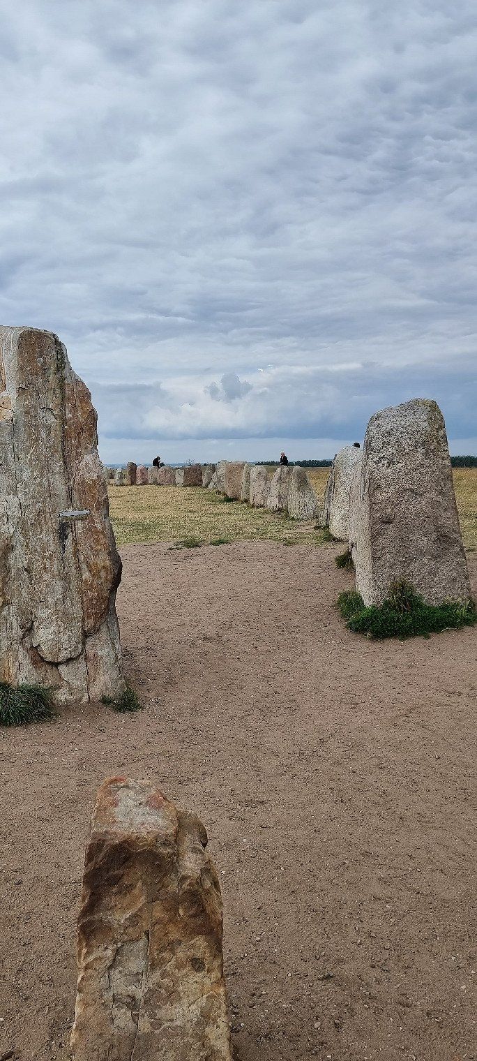
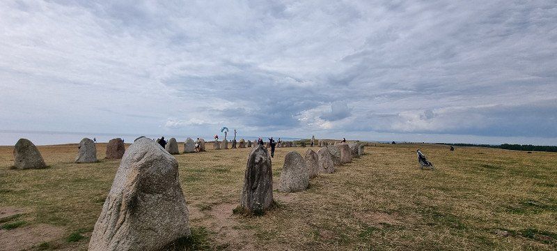
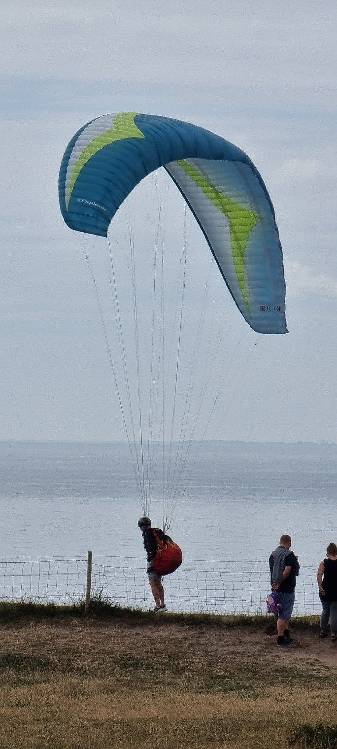
Kåseberga, Schweden
Ales Stenar - Ship-Settlement from Kåseberga
this is the oldest known ship setting in Sweden
it is estimated to be around the year 600 (around 1400 years old)
there are a total of 59 stones
through the day it is very popular with tourists
if you want a little more peace, you should stop by in the morning or evening
there is also an excellent view from the cliffs
the spot is very popular with paragliders
Photos taken with the DJI Mini 2
Schweden
55° 23' 17.9" N 14° 3' 48.8" E
55.3883125 14.0635625
• Head northwest. Go for 34 m.
• Turn right toward Ales väg. Go for 15 m.
• Turn left onto Ales väg. Go for 129 m.
• Turn left onto Östra Kustvägen. Go for 7.8 km.
• Turn left onto 9. Go for 8.5 km.
• Take the 2nd exit from roundabout onto Österleden toward E65/Centrum. Go for 1.4 km.
• Continue on Sjömansgatan. Go for 652 m.
• Continue on Karl XII:s gatan. Go for 186 m.
• Take the 3rd exit from roundabout onto Västerleden. Go for 1.6 km.
• Turn left. Go for 62 m.
• Arrive at your destination on the right.
☍
20,3 km
( 21 min.)
Ystad, Schweden
15th overnight stay
Location: parking space at Ystad
small, fine parking space directly on the Baltic Sea
it has two toi-tois in front of the payment machine
I wouldn't recommend swimming
it had a lot of seaweed and didn't look that inviting
Schweden
55° 25' 29.8" N 13° 47' 11.2" E
55.4249375 13.7864375
• Head toward Kommendörsgatan. Go for 62 m.
• Turn left onto Västerleden. Go for 1.2 km.
• Turn right onto Ringleden (9). Go for 2.2 km.
• Take the 3rd exit from Trafikplats Ystad roundabout onto Malmövägen (E65) toward Trelleborg. Go for 409 m.
• Pass 2 roundabouts and continue on E65. Go for 47.7 km.
• Take exit 14 toward Trelleborg onto E6/E20/E22 (Yttre Ringvägen). Go for 5.7 km.
• Continue on E20 (Yttre Ringvägen) toward Flygplats/Köpenhamn/Limhamn. Go for 13.7 km.
• Continue on E20 (Øresundsbroen). Go for 11.0 km.
• Take exit 15 toward Lufthavn. Go for 559 m.
• Turn right onto Amager Strandvej. Go for 4.6 km.
• Turn left onto Prags Boulevard. Go for 432 m.
• Continue on Uplandsgade. Go for 924 m.
• Turn right onto Vermlandsgade. Go for 453 m.
• Turn right onto Christmas Møllers Plads. Go for 112 m.
• Continue on Torvegade. Go for 719 m.
• Continue on Knippelsbro. Go for 139 m.
• Continue on Børsgade. Go for 130 m.
• Turn right onto Havnegade. Go for 172 m.
• Turn right onto Holmens Kanal. Go for 124 m.
• Turn left onto Holmens Kanal (O2). Go for 425 m.
• Turn left onto Kongens Nytorv. Go for 142 m.
• Turn left onto Kongens Nytorv (O2). Go for 111 m.
• Arrive at Kongens Nytorv (O2). Your destination is on the left.
☍
90,8 km
(1 hrs. 12 min.)
Day
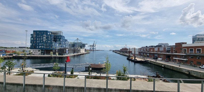
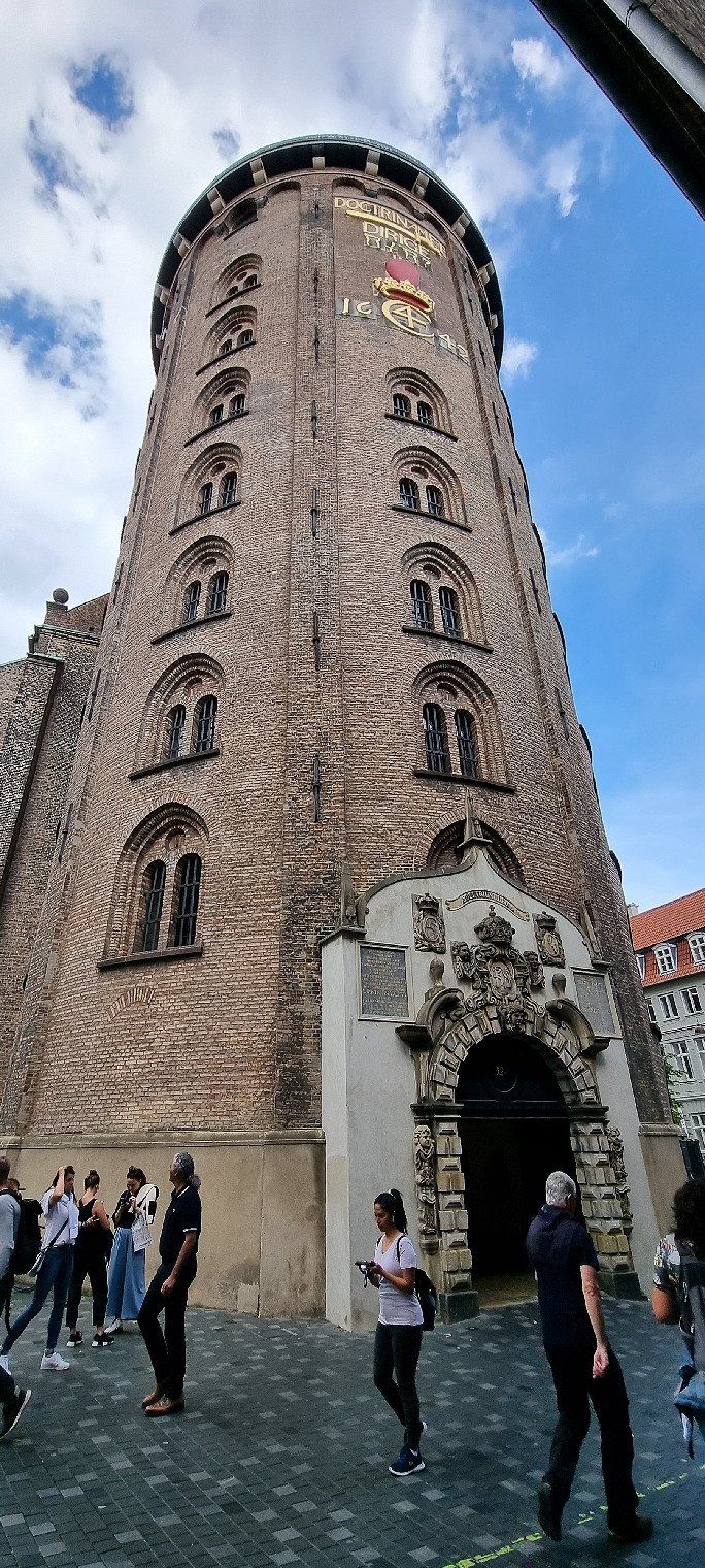
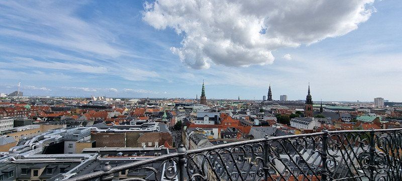
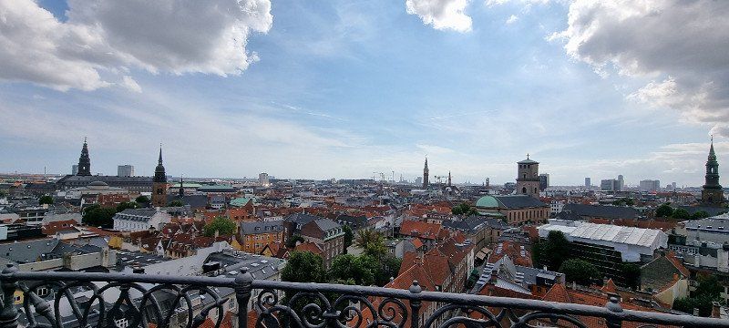
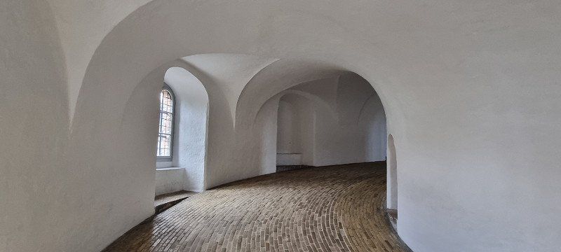
Kopenhagen City, Dänemark
Sightseeing in the city
including Nyhavn, Copenhagen Fortress, Rosenborg Castle, Round Tower, Tivoli and much more
We parked the mobile home in advance at the Copenhagen Autocamper Park parking space
We then took the bus (bus stop right at the entrance) and the metro to Kongens Nytorv in about 15 minutes
Dänemark
55° 40' 50" N 12° 35' 9.4" E
55.6805625 12.5859375
• Head south on Kongens Nytorv (O2). Go for 92 m.
• Turn left onto Kongens Nytorv (O2). Go for 188 m.
• Continue on Bredgade (O2). Go for 1.3 km.
• Turn right onto Folke Bernadottes Allé (O2) toward 16/19. Go for 2.1 km.
• Turn right onto Sundkrogsgade. Go for 696 m.
• Continue on Færgehavnsvej. Go for 110 m.
• Turn slightly right onto Containervej. Go for 99 m.
• Turn slightly left onto Færgehavnsvej. Go for 422 m.
• Turn slightly right onto Baltikavej. Go for 496 m.
• Turn right onto Skagerrakvej. Go for 66 m.
• Continue on Oceanvej. Go for 829 m.
• Turn left. Go for 27 m.
• Arrive at your destination.
☍
6,5 km
( 14 min.)
Kopenhagen Nordhavn, Dänemark
16th overnight stay
Location: Parking space near Nordhavn
a former car park that has been converted into an RV park during the summer season
the sanitary facilities were in a trailer
a total of three pieces, each with a shower and toilet in one cabin
the rooms were very clean
A few negative points: if three people were showering at the same time, we sometimes had to wait 5-10 minutes
Electricity and WiFi worked perfectly
the two hosts were very friendly and helpful
It should also be mentioned: the parking lot is very outside - by that I mean that building land is directly behind it and was being built
The docking station for large cruise ships is also not far from the Querstrasse
in the morning we knew the announcements by heart after a short time
Dänemark
55° 42' 52" N 12° 37' 8.6" E
55.7144375 12.6190625
• Head south. Go for 27 m.
• Turn right onto Oceanvej. Go for 829 m.
• Continue on Skagerrakvej. Go for 66 m.
• Turn left onto Baltikavej. Go for 496 m.
• Turn slightly left onto Færgehavnsvej. Go for 422 m.
• Turn slightly right onto Containervej. Go for 99 m.
• Turn slightly left onto Færgehavnsvej. Go for 110 m.
• Continue on Sundkrogsgade. Go for 596 m.
• Turn right onto Kalkbrænderihavnsgade (O2). Go for 2.7 km.
• Continue on 19 (Lyngbyvej). Go for 4.6 km.
• Keep left onto 201 toward Birkerød/Holte/E47s/Rødby/Lyngby V. Go for 325 m.
• Take the exit toward Rødby/E47s/Lyngby V onto Lyngbyvej. Go for 351 m.
• Keep right onto Lyngbyvej. Go for 133 m.
• Take ramp onto E47 (Motorring 3) toward E47s/E55s/Rødby. Go for 17.3 km.
• Take the exit toward Odense/Rødby/Gedser onto E20/E47 (Køge Bugt Motorvejen). Go for 26.4 km.
• Keep right onto E47/E55 (Køge Vest) toward Rødby/Gedser. Go for 77.6 km.
• Continue on E47 (Sydmotorvejen) toward Rødby. Go for 44.4 km.
• Arrive at your destination on the right.
☍
176,4 km
(1 hrs. 51 min.)
Day
Rødbyhavn, Dänemark
Crossing with the ferry to Puttgarden
We had already booked the ferry online in advance, which I would also recommend
on this day there would have been no other free time for spontaneous travelers
the ferry runs every 30 minutes
the check-in should take place no later than 15 minutes before departure
However, we were already there 30 minutes beforehand and were accordingly instructed in a waiting line
Dänemark
54° 39' 15.5" N 11° 21' 2.5" E
54.6543125 11.3506875
• Head southwest.
• Take the Rødby-Puttgarden Ferry. Stay on for 18.7 km.
• Head southwest on E47.
• Arrive at E47. Your destination is on the left.
☍
18,7 km
( 58 min.)
Puttgarden, Deutschland
Ferry Rødbyhavn - Puttgarden
there are five decks in total:
on the first deck are all trucks and RVs
on decks two and three are the cars
on deck four there are restrooms, a duty-free shop and a restaurant
on deck five there is a cafe and an outdoor terrace
you are not allowed to remain seated in the vehicles
the journey takes about 45 minutes
Deutschland
54° 30' 9.2" N 11° 13' 41" E
54.5025625 11.2280625
• Head southwest on E47. Go for 865 m.
• Continue on B207. Go for 21.3 km.
• Continue on A1. Go for 46.5 km.
• Take exit 16 toward Scharbeutz. Go for 368 m.
• Turn left onto B76/B432 toward Scharbeutz. Go for 1.6 km.
• Turn right onto Strandallee (B76) toward Lübeck-Travemünde/Timmendorfer Strand. Go for 473 m.
• Turn right onto Hamburger Ring (B76). Go for 1.0 km.
• Take the 2nd exit from roundabout onto Hamburger Ring (B76) toward Lübeck-Travemünde. Go for 7.6 km.
• Turn left onto Hafenstraße toward Niendorf-Hafen. Go for 87 m.
• Turn right onto Strandstraße. Go for 140 m.
• Turn left onto Grüner Weg. Go for 107 m.
• Turn slightly right. Go for 69 m.
• Arrive at your destination on the right.
☍
80,2 km
(1 hrs. 1 min.)
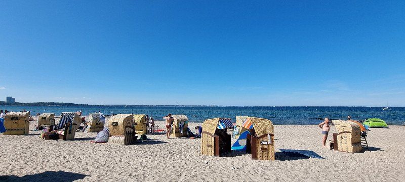
Niendorf, Deutschland
Free beach Niendorf
public sandy beach on the Baltic Sea
the rush at the Baltic Sea and the parking lots is of course huge
we parked our mobile home on the parking lot at the bird park and stayed there too
there are a lot of beach boxes on the beach
we squeezed ourselves in between somewhere at the edge
beach boxes can also be rented
if you swim out a little you come out on a sandbar to stand on
Deutschland
53° 59' 40.2" N 10° 48' 53.2" E
53.9945125 10.8147656
• Head toward Grüner Weg. Go for 69 m.
• Turn slightly left onto Grüner Weg. Go for 107 m.
• Turn right onto Strandstraße. Go for 140 m.
• Turn left onto Hafenstraße. Go for 87 m.
• Continue on Hafenstraße. Go for 62 m.
• Turn right. Go for 94 m.
• Arrive at your destination on the right.
☍
0,6 km
( 2 min.)
Niendorf, Deutschland
17th overnight stay
Location: RV parking lot Niendorf
a normal mobile home parking space
some of the pitches are under trees = shady
but is right next to the main road (went for one night)
there have already been a lot of mobile homes here, but still a lot of space and distances between them
Electricity is available, but you had to pay separately
public toilets are also available and were clean
there is no shower
Deutschland
53° 59' 26" N 10° 48' 46.1" E
53.9905625 10.8128125
• Head northeast. Go for 94 m.
• Turn left onto Hafenstraße. Go for 62 m.
• Turn right onto Timmendorfer Strand (B76). Go for 4.0 km.
• Take ramp onto B75 toward A1/Hamburg/Puttgarden/Lübeck/Fähre Skandinavienkai/Industriegebiet Skandinavienkai-Nord/Industriegebiet Skandinavienkai-Süd. Go for 8.2 km.
• Keep left onto A226 toward Hamburg/A1/Puttgarden/Rostock/A20. Go for 5.4 km.
• Continue on A1. Go for 54.8 km.
• Take exit 31 toward Hamburg/HH-Jenfeld onto A24. Go for 7.4 km.
• Take the 1st exit from Horner Kreisel roundabout onto Sievekingsallee toward Elbbrücken/Stadion Arena/Centrum. Go for 2.1 km.
• Continue on Bürgerweide. Go for 816 m.
• Keep left onto Bürgerweide (B75) toward Elbbrücken. Go for 509 m.
• Turn right onto Spaldingstraße. Go for 1.0 km.
• Continue on Amsinckstraße (B4). Go for 163 m.
• Keep left onto B4 toward Altona/A7/Centrum/Messe/CCH. Go for 1.5 km.
• Turn slightly left toward Landungsbrücken. Go for 33 m.
• Turn slightly left onto Rödingsmarkt toward Landungsbrücken. Go for 266 m.
• Continue on Binnenhafenbrücke. Go for 144 m.
• Continue on Baumwall. Go for 170 m.
• Continue on Vorsetzen. Go for 144 m.
• Turn left toward Neustädter Neuer Weg. Go for 27 m.
• Arrive at Neustädter Neuer Weg. Your destination is on the left.
☍
86,9 km
(1 hrs. 1 min.)
Day
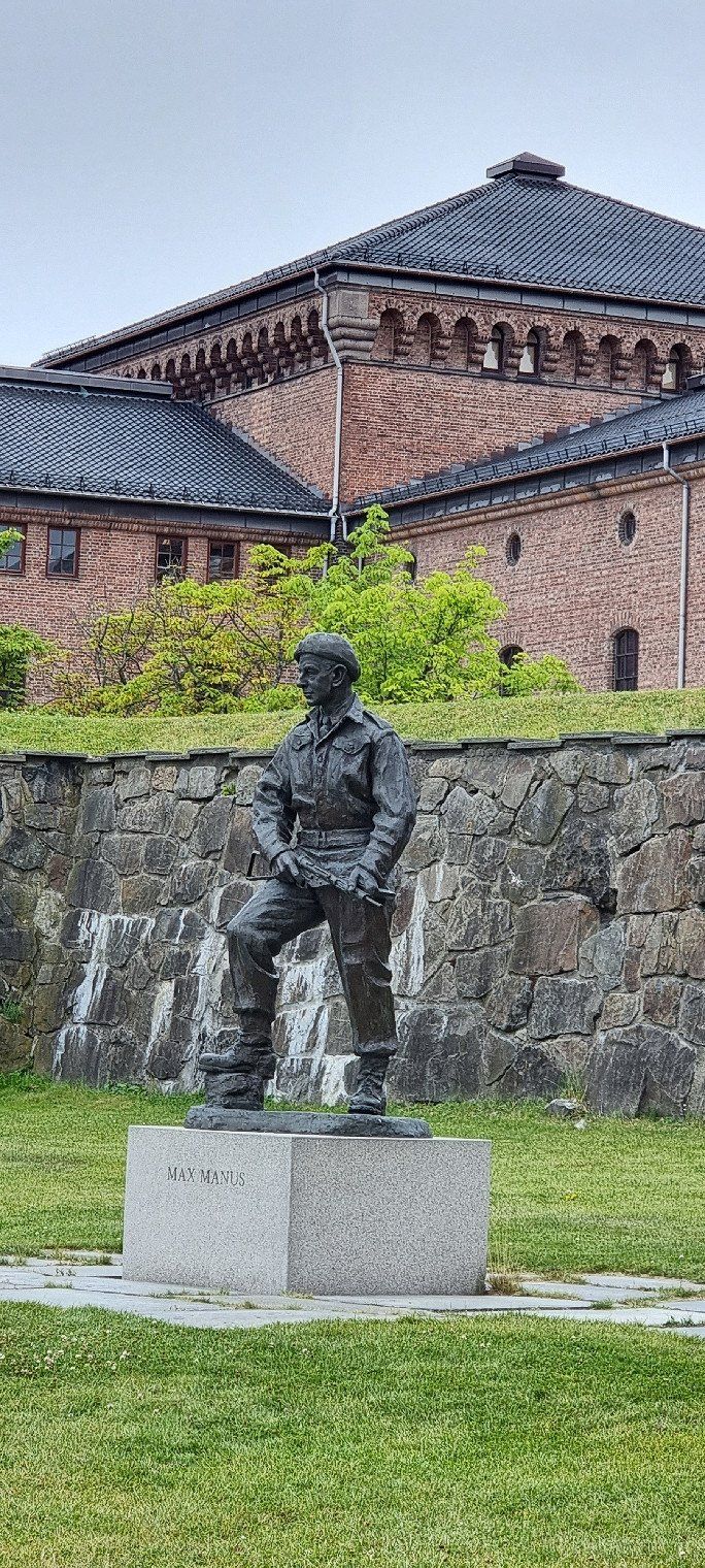
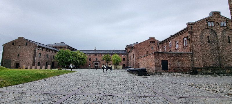
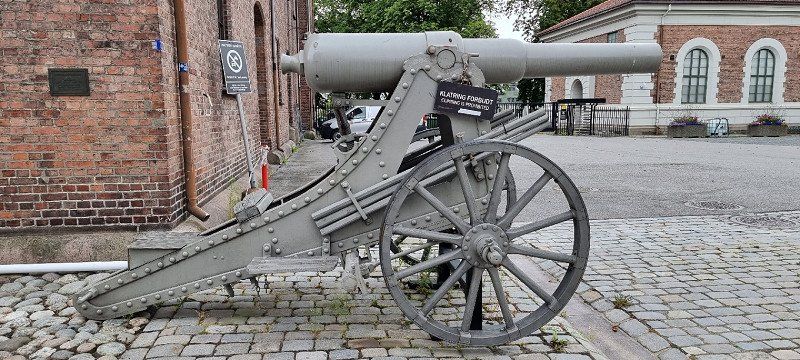
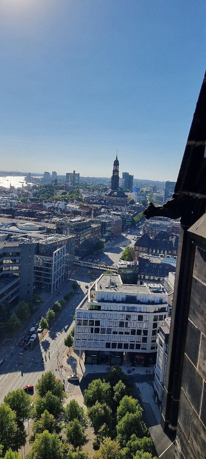
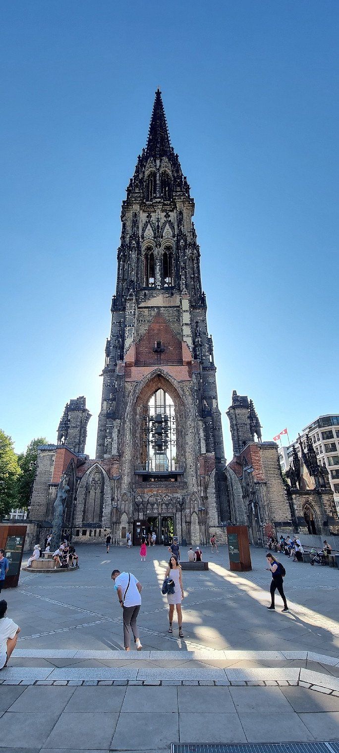
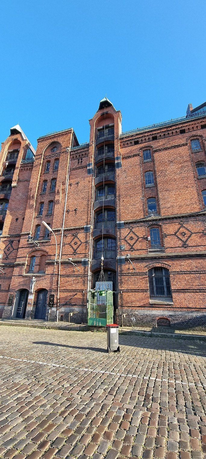
Hamburg, Deutschland
Sightseeing in the city
Landungsbrücken, St. Nikolai Memorial (and observation tower), City Hall, Speicherstadt, Miniature Wonderland and much more
We parked the mobile home in advance at the Fischmarkt parking space
from there you can explore the city comfortably on foot along the Elbe
Deutschland
53° 32' 38.6" N 9° 58' 42" E
53.5440625 9.9783281
• Head south on Vorsetzen.
• Turn left onto Vorsetzen. Go for 147 m.
• Continue on Baumwall. Go for 148 m.
• Make a U-Turn at Niederbaumbrücke onto Baumwall. Go for 157 m.
• Continue on Vorsetzen. Go for 356 m.
• Continue on Johannisbollwerk. Go for 205 m.
• Continue on Bei den Sankt Pauli-Landungsbrücken. Go for 207 m.
• Continue on Sankt Pauli Hafenstraße. Go for 642 m.
• Continue on Sankt Pauli Fischmarkt. Go for 411 m.
• Turn left onto Große Elbstraße toward Fischereihafen. Go for 109 m.
• Turn left. Go for 16 m.
• Turn left. Go for 40 m.
• Arrive at your destination on the left.
☍
2,4 km
( 5 min.)
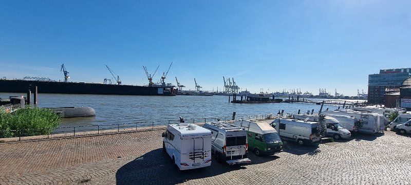
Hamburg, Deutschland
18th overnight stay
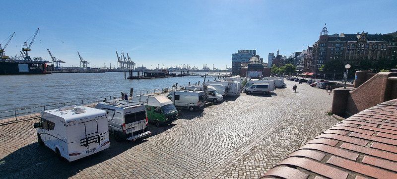
Location: RV parking space Fischmarkt, Hamburg
the parking space is located directly on the Elbe
we asked the nice gentleman at the ticket booth if there were still seats
he said yes, we should go have a quick look and when we have found a place we should pay
There is enough space there - by the evening more mobile homes had arrived
the whole pitch is kept very simple
there is a public toilet above the street (70 cents, but it is only open until 5 p.m.)
there is no shower here
If you don't mind that people pass by in front and behind the row of mobile homes, you will be able to stay here for one more night
Deutschland
53° 32' 43.1" N 9° 57' 11" E
53.5453125 9.9530625
• Head west. Go for 40 m.
• Turn right toward Große Elbstraße. Go for 16 m.
• Turn right onto Große Elbstraße. Go for 109 m.
• Turn left onto Sankt Pauli Fischmarkt. Go for 61 m.
• Turn right onto Pepermölenbek. Go for 2.1 km.
• Continue on Kieler Straße (B4). Go for 1.1 km.
• Turn slightly left onto Kieler Straße (B4/B5). Go for 109 m.
• Keep right onto Kieler Straße (B4/B5). Go for 2.7 km.
• Take ramp onto A7 toward Flensburg/Kiel/Husum/Heide/A23/Flughafen/B4/B5. Go for 5.6 km.
• Take exit 23 toward Flughafen Hamburg onto B432 (Oldesloer Straße). Go for 1.7 km.
• Keep left onto Oldesloer Straße (B432) toward Bad Segeberg/Norderstedt/B433. Go for 5.3 km.
• Take the 2nd exit from roundabout onto Segeberger Chaussee (B432) toward Bad Segeberg. Go for 2.1 km.
• Continue on Segeberger Chaussee (B432) toward Bad Segeberg. Go for 9.5 km.
• Arrive at Segeberger Straße (B432). Your destination is on the left.
☍
30,4 km
( 41 min.)
Day
Kayhude, Deutschland
End / vehicle delivery
hassle-free vehicle delivery on site at MC Rent
Deutschland
53° 44' 57.1" N 10° 7' 32" E
53.7491875 10.1255625