Abfahrt am Freitag den 23. Aug. 2024
Solms, Deutschland
35606 Solms, Deutschland
50° 33' 7.1" N 8° 24' 59.4" E
50.5519629 8.4165038
• Head east on B49. Go for 9.8 km.
• Take ramp onto A45 toward Frankfurt. Go for 17.7 km.
• Take exit 35 toward Basel/Frankfurt/Wiesbaden onto A5. Go for 41.1 km.
• Take exit 18 toward Wiesbaden/F-Höchst onto A66. Go for 32.0 km.
• Take exit 3 toward Koblenz/Bingen/Mainz/WI-Äppelallee/WI-Schierstein onto A643. Go for 6.7 km.
• Take the left exit toward Trier/Koblenz/Bingen onto A60. Go for 21.9 km.
• Take the left exit toward Ludwigshafen/Bad Kreuznach onto A61. Go for 4.0 km.
• Take exit 51 toward Bad Kreuznach/Idar-Oberstein/Sprendlingen/Langenlonsheim/B50 onto B41. Go for 21.8 km.
• Turn left onto Steinhardter Straße toward Waldböckelheim. Go for 283 m.
• Turn right toward Berliner Straße. Go for 28 m.
• Continue on Berliner Straße. Go for 48 m.
• Turn right onto L234. Go for 4.7 km.
• Turn left onto Sobernheimer Straße (L234). Go for 1.8 km.
• Turn right onto Hauptstraße (L234). Go for 848 m.
• Take the 2nd exit from roundabout onto L234. Go for 6.9 km.
• Turn right onto B420. Go for 1.9 km.
• Turn left onto Deslocher Straße. Go for 61 m.
• Turn slightly right onto Deslocher Straße. Go for 72 m.
• Turn left onto Obertor (K65). Go for 585 m.
• Continue on Amtsgasse. Go for 67 m.
• Turn left onto Stadtgraben. Go for 116 m.
• Arrive at Stadtgraben. Your destination is on the right.
☍
172,3 km
(1 hrs. 45 min.)
Meisenheim
Landkreis Bad Kreuznach, Rheinland-Pfalz, Deutschland
49° 42' 23.9" N 7° 40' 12.3" E
49.7066470 7.6700779
• Head toward Klenkertor on Stadtgraben. Go for 182 m.
• Continue on An der Bleiche. Go for 129 m.
• Turn left onto Schillerstraße. Go for 180 m.
• Turn right onto Saarstraße. Go for 131 m.
• Turn slightly left onto Saarstraße. Go for 137 m.
• Arrive at Saarstraße. Your destination is on the left.
☍
0,8 km
( 1 min.)
Wohnmobilstellplatz Meisenheim
Bismarckplatz 3, 55590, Meisenheim, Germany
49° 42' 35" N 7° 39' 58.4" E
49.7097300 7.6662200
• Head west on Saarstraße.
• Turn right onto Heimbacher Weg. Go for 18 m.
• Turn right onto Am Stadtpark. Go for 132 m.
• Turn left onto Raumbacher Straße. Go for 484 m.
• Turn left onto B420. Go for 542 m.
• Turn right onto In der Heimbach. Go for 245 m.
• Turn left onto In der Heimbach. Go for 21 m.
• Arrive at In der Heimbach. Your destination is on the left.
☍
1,4 km
( 3 min.)
Stellplatz Heimbachtal
In der Heimbach, 55590, Meisenheim, Deutschland
49° 42' 53" N 7° 39' 27" E
49.7147222 7.6575000
• Head northeast on In der Heimbach. Go for 21 m.
• Turn right onto In der Heimbach. Go for 221 m.
• Turn slightly left onto In der Heimbach. Go for 24 m.
• Turn right onto B420. Go for 10.2 km.
• Turn right and take ramp toward Kaiserslautern/Idar-Oberstein/Auf Röth. Go for 187 m.
• Turn left onto B270. Go for 13.4 km.
• Turn right onto L370. Go for 3.2 km.
• Turn left onto Kollweilerstraße (L372). Go for 4.2 km.
• Turn left onto L369 toward Schwedelbach. Go for 1.7 km.
• Continue on Kollweilerstraße (L369). Go for 549 m.
• Turn right onto Hauptstraße (K13). Go for 757 m.
• Turn left onto L367. Go for 2.1 km.
• Take the 2nd exit from roundabout onto L356 toward Saarbrücken/A6/A62/Landstuhl/Ramstein-Miesenbach. Go for 5.4 km.
• Take the 2nd exit from roundabout onto L356 toward A6/A62/Landstuhl/Bruchmühlbach-Miesau/Gewerbegebiet Westrich. Go for 754 m.
• Take the 3rd exit from roundabout onto L363. Go for 1.8 km.
• Take ramp onto A6 toward Saarbrücken/Pirmasens/Trier. Go for 47.3 km.
• Keep left onto A620 toward Luxembourg/A8/Saarlouis/Sarreguemines/B51/Saarbrücken. Go for 33 m.
• Continue on A6. Go for 522 m.
• Continue on A620. Go for 450 m.
• Take exit 21 toward Sarreguemines/Kleinblittersdorf/Güdingen. Go for 324 m.
• Turn left onto Wolfseck (B51) toward Sarreguemines/Kleinblittersdorf/Güdingen/Gewerbegebiet Bübingen Brebach. Go for 7.5 km.
• Pass 2 roundabouts and continue on Konrad-Adenauer-Straße (B51). Go for 4.9 km.
• Continue on Rue Alexandre de Geiger (D82 A). Go for 105 m.
• Turn right onto Rue Alexandre de Geiger (D82 A). Go for 182 m.
• Turn right onto Rue Clemenceau (D974). Go for 311 m.
• Take ramp onto Avenue du Général de Gaulle (D33). Go for 570 m.
• Turn right. Go for 96 m.
• Arrive at your destination on the right.
☍
106,8 km
(1 hrs. 25 min.)
Day
Saargemünd
Mosel, Grand Est, Frankreich
49° 6' 34.1" N 7° 4' 15.2" E
49.1094836 7.0708865
• Head toward Boulevard des Faïenceries. Go for 96 m.
• Continue on Boulevard des Faïenceries (D33). Go for 17 m.
• Take the 3rd exit from roundabout onto Rue Raymond Poincaré (D33). Go for 593 m.
• Take the 3rd exit from roundabout toward Ingwiller/Herbitzheim/Rémelfing. Go for 137 m.
• Turn right onto Rue de Steinbach (D919). Go for 195 m.
• Turn left onto Rue de Steinbach. Go for 40 m.
• Arrive at Rue de Steinbach.
☍
1,1 km
( 2 min.)
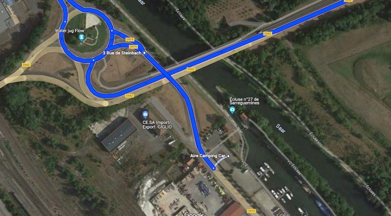
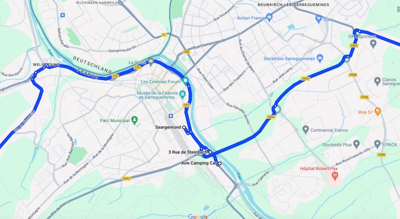
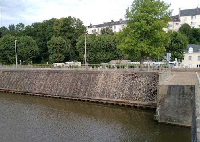
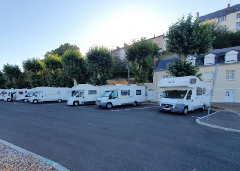
Aire Camping Car 9-15 Rue de Steinbach, 57200 Sarreguemines Saargemünd
Aire Camping Car 9-15 Rue de Steinbach, 57200 Sarreguemines
according to Promobil motorhome parking Aire d'Accueil de Camping-cars in Sarreguemines
Paid parking space for 10 mobile homes on the outskirts of Sarreguemines. The parking space is close to the river. Mostly flat space. Partly paved, gravelled and cobbled surface. Center can be reached on foot. On site: fresh water, electricity, grey water disposal, dogs allowed.
Nearby: Musée, Jardin des Faïenciers, Church of St. Marcel in Zettingen.
Price per night: 5.00 EUR
Payment: Parking meter
Electricity: 50 cents/1 kWh,
Water: 1 Euro/100 Ltr.
Rue de Steinbach 7BIS, Saargemünd, Mosel, Grand Est, Frankreich
49° 6' 7.9" N 7° 4' 36.7" E
49.1021989 7.0768698
• Head southwest on Rue de Steinbach. Go for 40 m.
• Turn right onto Rue de Steinbach (D919). Go for 213 m.
• Take the 2nd exit from roundabout onto Route de Nancy (D662) toward Metz/Nancy-St Avold/Saarbrücken. Go for 3.0 km.
• Take the 3rd exit from roundabout onto N61 toward A4/Strasbourg/Nancy/Metz/Puttelange aux L. Go for 2.1 km.
• Take the 2nd exit from roundabout onto N61 toward Metz/Strasbourg/Sarralbe/Willerwald/Europôle de Sarreguemines. Go for 3.9 km.
• Take the 2nd exit from roundabout onto A4 (Autoroute de l'Est) toward Metz/Paris. Go for 62.8 km.
• Keep left onto A314 toward Metz/Nancy. Go for 1.5 km.
• Take the left exit toward Nancy/Aéroport Régional/Technopole/Actipole onto A315. Go for 1.2 km.
• Continue on N431. Go for 14.5 km.
• Take the 2nd exit from roundabout toward Nancy/Pagny S/M./Fey. Go for 178 m.
• Take the 2nd exit from roundabout onto A31 toward Nancy. Go for 33.9 km.
• Take exit 23 toward Malzéville/Bouxières aux D./Parc Nancy-Pompey-Logistique onto D321 (Voie Express Banlieue-Est). Go for 3.3 km.
• Take the 2nd exit from roundabout onto Voie Express Banlieue-Est (D321). Go for 277 m.
• Continue on M321. Go for 838 m.
• Take the 2nd exit from Rond-Point de Pixéricourt roundabout onto M321 toward Nancy/Saint Max/Dommartemont/Plateau de Malzéville. Go for 2.1 km.
• Take the 2nd exit from roundabout onto M321 toward Nancy/Saint Max/Dommartemont/Plateau de Malzéville. Go for 1.1 km.
• Continue on Viaduc Louis Marin. Go for 743 m.
• Take ramp. Go for 156 m.
• Continue on Boulevard du 26ème Régiment d'Infanterie. Go for 100 m.
• Continue on Boulevard du 26ème Régiment d'Infanterie. Go for 514 m.
• Continue on Porte Sainte-Catherine. Go for 26 m.
• Turn right onto Rue Sainte-Catherine toward Quartier Stanislas/Cité Administrative/Préfecture. Go for 357 m.
• Turn left onto Rue Guibal. Go for 36 m.
• Continue on Place d'Alliance. Go for 67 m.
• Turn right onto Rue Pierre Fourier. Go for 199 m.
• Turn left onto Rue Saint-Julien. Go for 54 m.
• Turn left onto Rue Claude Charles. Go for 24 m.
• Arrive at Rue Claude Charles. Your destination is on the right.
☍
133,3 km
(1 hrs. 24 min.)
Day
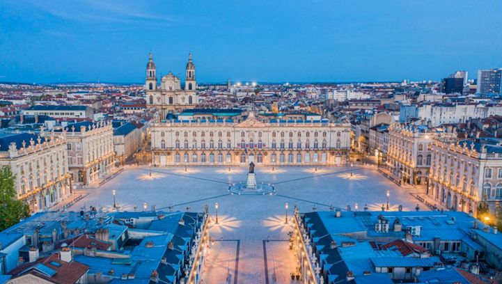
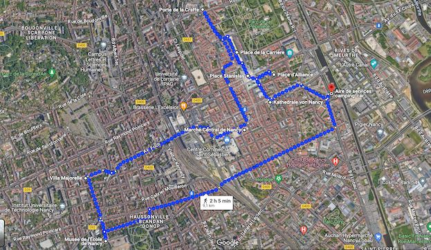
Nancy, Frankreich UNESCO-Weltkulturerbe
Nancy, a riverside town known for its late Baroque and Art Nouveau architecture, some of which date back to its time as the capital of the Dukes of Lorraine.
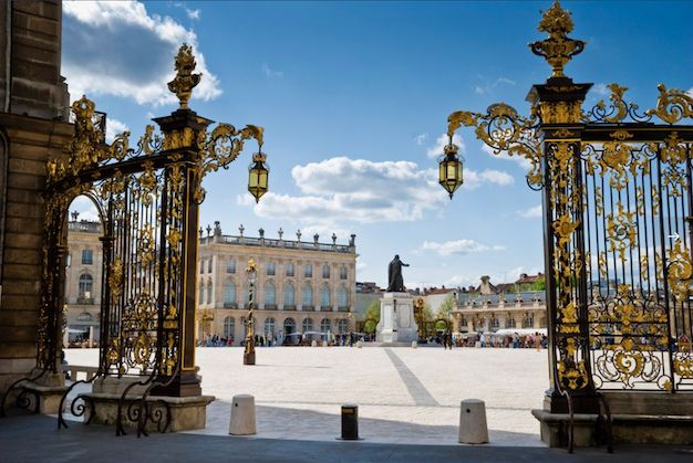
The main attraction is the 18th-century Place Stanislas. This square with gilded wrought-iron gates and Rococo fountains is located next to ornate palaces and churches in the historic old town. It has a side length of 106 x 124 meters.
Wine flows from the fountains when Stanislas inaugurates one of the most beautiful squares in the world in 1755, making Nancy the city with the "golden gates". This square alone is worth a trip.
Place Stanislas, along with the Carrière and Alliance squares and the Arc de Triomphe, is part of an 18th-century ensemble that was added to the UNESCO World Heritage List in 1983.
Nancy, Frankreich
48° 41' 31.4" N 6° 11' 3.9" E
48.6920540 6.1844170
• Head toward Rue Maurice Barrès on Rue Claude Charles. Go for 57 m.
• Turn right onto Rue Maurice Barrès. Go for 91 m.
• Turn left onto Rue Saint-Georges. Go for 325 m.
• Turn right onto Place de la Division de Fer. Go for 23 m.
• Continue on Place de la Division de Fer toward Jarville/Quartier Charles III. Go for 253 m.
• Turn left onto Boulevard du 21ème Régiment d'Aviation (D570). Go for 52 m.
• Arrive at Boulevard du 21ème Régiment d'Aviation (D570). Your destination is on the right.
☍
0,8 km
( 2 min.)
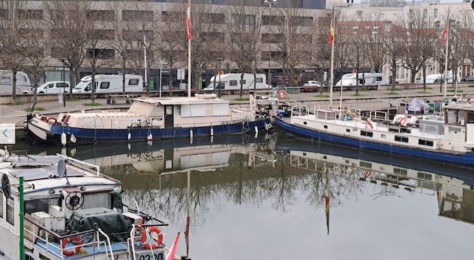
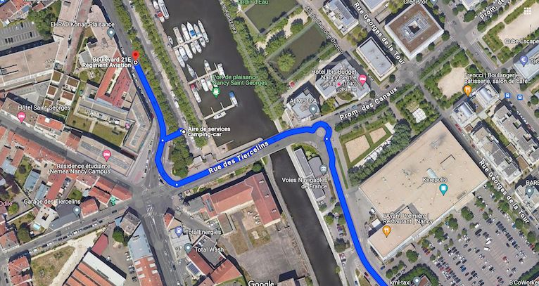
Aire de Camping-cars Port St. Georges
according to Promobil
Motorhome parking Parking Port St-Georges in Nancy16.50 EUR/night22 reviews
Paid parking space for 15 mobile homes in Nancy. The parking space is located at a marina and in a parking lot. Partly uneven and partly shaded area. Paved surface. Center can be reached on foot. Public transport connection at the parking space. On site: electricity, shower. Nearby: old town, museums, harbor/marina. Price per night including two adults: 16.50 - 17.10 euros depending on the season. Payment: harbor master. Water, chemical toilet disposal, toilet, dogs included in the overnight price. Electricity: 2 euros, shower: 1.60 euros. Maximum stay: 2 nights.
Boulevard du 21 Régiment d'Avation, 54000, Nancy, France
48° 41' 32" N 6° 11' 35" E
48.6922222 6.1930556
• Head north on Boulevard du 21ème Régiment d'Aviation (D570). Go for 1.8 km.
• Turn left onto Rue de la Citadelle. Go for 54 m.
• Turn right onto Rue Henri Deglin. Go for 132 m.
• Turn left onto Boulevard Charles V. Go for 265 m.
• Continue on Place du Luxembourg. Go for 32 m.
• Turn right onto Place du Luxembourg (D570). Go for 40 m.
• Turn right onto Place du Luxembourg (D570). Go for 80 m.
• Turn left onto Place du Luxembourg (D570). Go for 27 m.
• Continue on Rue Désilles. Go for 265 m.
• Continue on Rue de Verdun. Go for 451 m.
• Turn slightly right onto Avenue de la Libération (D400) toward Toul/Paris/Lyon/Champ le Boeuf. Go for 3.1 km.
• Take ramp onto Échangeur de Nancy-Gentilly toward Paris/Toul. Go for 1.1 km.
• Continue on A31. Go for 18.3 km.
• Take exit 12 toward Paris/Reims/Troyes Par RN/Bar le Duc onto N4. Go for 20.3 km.
• Take ramp toward Neufchâteau/Vaucouleurs/Void-Vacon. Go for 328 m.
• Take the 3rd exit from roundabout onto D964 toward Neufchâteau/Vaucouleurs. Go for 199 m.
• Take the 2nd exit from roundabout onto D964 toward Neufchâteau/Vaucouleurs/Gondrecourt. Go for 778 m.
• Turn right onto Rue de la Gare (D10) toward Sauvoy/Mauvages/Gondrecourt-le-Ch./Ourches. Go for 15.2 km.
• Turn right onto Grande Rue La Grande Rue à Rosieres (D960). Go for 5.9 km.
• Continue on Rue d'Orleans (D960) toward Bonnet/Joinville. Go for 12.1 km.
• Take the 2nd exit from roundabout onto D960. Go for 851 m.
• Continue on D60. Go for 17.0 km.
• Take the 2nd exit from roundabout onto D60. Go for 2.1 km.
• Continue on Rue Aristide Briand. Go for 235 m.
• Turn left onto Rue de la Fontaine. Go for 22 m.
• Turn right onto Rue des Chanoines. Go for 65 m.
• Turn right onto Rue Marcand. Go for 62 m.
• Continue on Rue de l'Auditoire. Go for 73 m.
• Arrive at Rue de l'Auditoire. Your destination is on the right.
☍
101,0 km
(1 hrs. 22 min.)
Day
Day
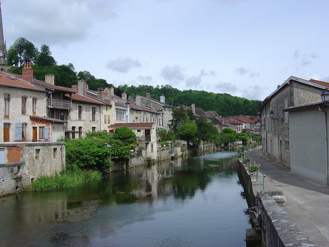
Joinville
Joinville is located on the Marne River, which runs through the city. Downstream of the city, the Marne is regulated by the largest reservoir in France, the Lake of Der-Chantecoq. The river also feeds the Canal entre Champagne et Bourgogne (
Canal between Champagne and Burgundy ), which - via other rivers and canals - provides a navigable connection from the Paris area to the Mediterranean.
Sights in Joinville (Haute-Marne)
- Former city fortifications from the 16th and 17th centuries
- The quays on the banks of the Marne
- Notre-Dame church from the 12th and 13th centuries
- 16th-century "Grand Jardin" castle with wonderful Renaissance gardens
Haute-Marne, Grand Est, Frankreich
48° 26' 36" N 5° 8' 15.9" E
48.4433253 5.1377537
• Head north on Rue de l'Auditoire. Go for 44 m.
• Turn right onto Rue des Royaux. Go for 36 m.
• Turn slightly left onto Rue des Ursulines. Go for 69 m.
• Turn right onto Rue des Ursulines. Go for 77 m.
• Turn right onto Rue Nicolas Thouvenin. Go for 290 m.
• Turn right onto Rue de la Harpe (D200). Go for 284 m.
• Turn left onto Rue Aristide Briand (D60). Go for 120 m.
• Arrive at Avenue de Lorraine (D60).
☍
0,9 km
( 2 min.)
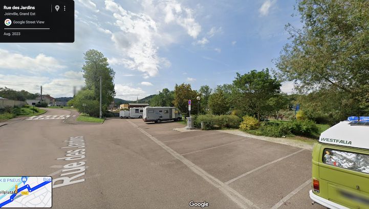
Wohnmobilstellplatz Avenue de Lorraine
Motorhome parking16 Av. de Lorraine, 52300 Joinville, France
according to Promobil
© SolutionsMotorhome parking Halte Nautique in Joinville4 reviews
Free parking space for 12 mobile homes in Joinville -La Madeleine. Paved surface. On site: kiosk, fresh water, electricity, grey water disposal, chemical toilet disposal, dogs allowed. Electricity: 2 euros/55 mins, water: 2 euros/10 mins.
Parking space by the canal with seating in the green. Quiet at night. Good supply and disposal. Close to town.
September 18, 2023, 08:18 am
Haute-Marne, Grand Est, Frankreich
48° 26' 34.4" N 5° 8' 35.8" E
48.4428971 5.1432758
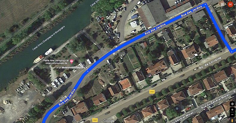
• Head toward Chemin des Fonderies on Avenue de Lorraine (D60). Go for 500 m.
• Turn left onto Rue des Jardins. Go for 234 m.
• Turn right onto Rue des Jardins. Go for 55 m.
• Turn right onto Avenue de Lorraine (D60). Go for 831 m.
• Turn left onto Rue Mauclère (D200). Go for 559 m.
• Turn slightly right onto Rue Camille Gillet (D60). Go for 5.3 km.
• Keep left onto Rue de la Libération (D60). Go for 8.5 km.
• Turn left onto Rue Maréchal de Lattre de Tassigny (D60). Go for 16.3 km.
• Turn right onto Grande Rue (D60). Go for 4.0 km.
• Continue on D960. Go for 16.2 km.
• Turn left onto D102. Go for 1.3 km.
• Turn right onto D396. Go for 43 m.
• Turn left onto D102. Go for 240 m.
• Continue on Rue Napoléon Bonaparte (D102). Go for 142 m.
• Turn left onto Rue du Général Leclerc de Hauteclocque (D443). Go for 386 m.
• Turn right onto Rue du Vieux Moulin (D11 B). Go for 428 m.
• Continue on D11 B. Go for 1.8 km.
• Continue on Grande Rue (D11 B). Go for 13.6 km.
• Turn left onto Rue des Frères Hubert (D960). Go for 5.0 km.
• Continue on D960. Go for 11.9 km.
• Take the 3rd exit from roundabout onto D960 toward A5/Paris/Lyon/Troyes/Chaumont. Go for 398 m.
• Take the 2nd exit from roundabout onto Avenue Jules Guesde (D960). Go for 1.7 km.
• Continue on Place Charles de Gaulle. Go for 39 m.
• Continue on Rue Roger Salengro. Go for 451 m.
• Continue on Avenue Robert Schuman. Go for 655 m.
• Continue on Carrefour de l'Europe. Go for 67 m.
• Continue on Avenue du 1er Mai. Go for 376 m.
• Turn right onto Cours Jacquin. Go for 607 m.
• Continue on Boulevard Danton. Go for 427 m.
• Take the 2nd exit from roundabout onto Quai de Dampierre. Go for 150 m.
• Take the 1st exit from roundabout onto Boulevard Gambetta. Go for 264 m.
• Turn left toward Place Jean Moulin. Go for 66 m.
• Turn right onto Rue de la République. Go for 218 m.
• Continue on Place Maréchal Foch. Go for 49 m.
• Turn right onto Rue Urbain IV. Go for 34 m.
• Turn right onto Place Maréchal Foch. Go for 21 m.
• Arrive at Place Maréchal Foch. Your destination is on the right.
☍
92,9 km
(1 hrs. 30 min.)
Day
Day
Day
Troyes
Aube, Grand Est, Frankreich
48° 17' 49.8" N 4° 4' 28.7" E
48.2971626 4.0746257
• Head toward Place Alexandre Israël on Place Maréchal Foch. Go for 37 m.
• Turn slightly right onto Rue Aristide Briand. Go for 95 m.
• Turn right onto Rue Claude Huez. Go for 80 m.
• Turn left onto Rue de la République. Go for 126 m.
• Turn right onto Boulevard Gambetta. Go for 249 m.
• Take the 3rd exit from roundabout onto Quai de Dampierre. Go for 133 m.
• Take the 2nd exit from roundabout onto Avenue Chomedey de Maisonneuve. Go for 910 m.
• Pass 2 roundabouts and continue on Avenue Chomedey de Maisonneuve. Go for 900 m.
• Continue on Rue Pénétrante Nord. Go for 1.6 km.
• Take ramp onto Rocade Nord (D610). Go for 1.6 km.
• Take ramp toward Provins/Paris/Soissons/Romilly S/Seine/La Chapelle St Luc/Aérodrome Troyes-Barberey. Go for 728 m.
• Continue on D619. Go for 5.7 km.
• Take the 3rd exit from roundabout onto D442. Go for 18.5 km.
• Turn right onto Rue Georges Clemenceau (D442). Go for 20.0 km.
• Pass 2 roundabouts and continue on Avenue du Général de Gaulle (D919). Go for 1.1 km.
• Take the 1st exit from roundabout onto Avenue Pasteur (D919). Go for 208 m.
• Take the 2nd exit from Place d'Armes roundabout onto Rue de l'Étape au Vin (D919). Go for 222 m.
• Turn slightly left onto Grande Rue Saint-Laurent (D951). Go for 205 m.
• Turn left onto Rue des Fossés. Go for 17 m.
• Arrive at Rue des Fossés. Your destination is on the left.
☍
52,4 km
( 49 min.)
Day
Day
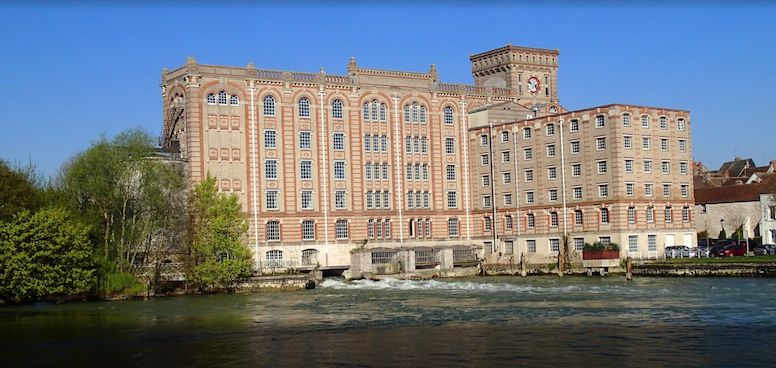
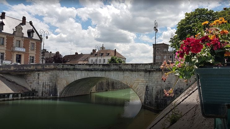
Nogent-sur-Seine
Nogent lies on the Seine, which is navigable up to here, and on the road from Provins to Romilly-sur-Seine.
The Nogent nuclear power plant is located about two kilometers upstream.
Nogent is located 112 km ESE of Paris by road, but thanks to pronounced loops of the Seine it is about 160 km above Paris by river.
Aube, Grand Est, Frankreich
48° 29' 32.8" N 3° 29' 52.1" E
48.4924390 3.4978181
• Head south on Rue des Fossés. Go for 263 m.
• Turn left onto Rue du Plat d'Étain. Go for 113 m.
• Turn left onto Grande Rue Saint-Laurent (D951). Go for 265 m.
• Turn right onto Place de la Halle. Go for 75 m.
• Arrive at Place de la Halle.
☍
0,7 km
( 2 min.)
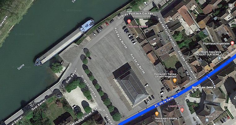
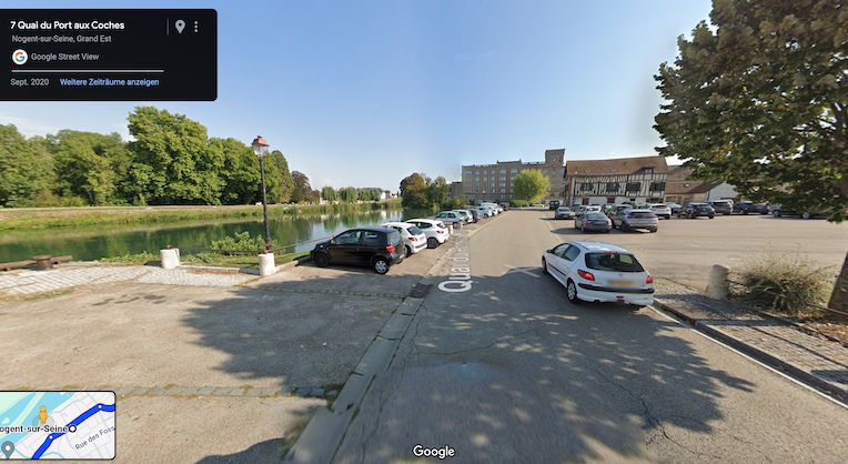
Stellplatz in Nogent-sur-Seine
Rue de la Comédie
Aube, Grand Est, Frankreich
48° 29' 34" N 3° 29' 46.4" E
48.4927883 3.4962204
• Head toward Quai Sarrail on Place de la Halle. Go for 12 m.
• Turn slightly right onto Quai du Port aux Coches. Go for 58 m.
• Turn right onto Place de la Halle. Go for 101 m.
• Turn right onto Place de la Halle (D951). Go for 428 m.
• Turn right onto Route de Bray (D951). Go for 701 m.
• Take the 3rd exit from roundabout onto Route de Bray (D951). Go for 126 m.
• Take ramp onto D619 toward Paris/Villenauxe la Gde/Sézanne. Go for 15.3 km.
• Take the 1st exit from roundabout onto D74 A. Go for 1.2 km.
• Continue on Avenue du Maréchal de Lattre de Tassigny (D74) toward Provins-Centre. Go for 756 m.
• Continue on Rue Edmond Nocard. Go for 168 m.
• Turn left onto Place Saint-Ayoul (D403). Go for 37 m.
• Continue on Rue de la Cordonnerie (D403). Go for 154 m.
• Continue on Place du Maréchal Leclerc (D403). Go for 52 m.
• Turn right onto Place du Maréchal Leclerc (D403). Go for 15 m.
• Arrive at Place du Maréchal Leclerc (D403). Your destination is on the right.
☍
19,2 km
( 19 min.)
Day
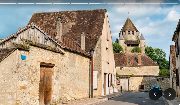
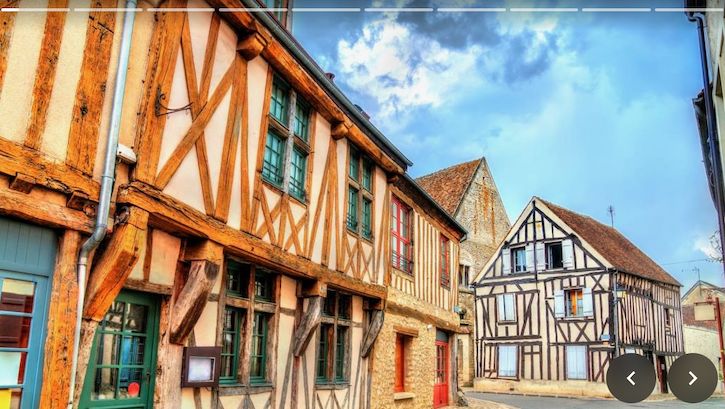
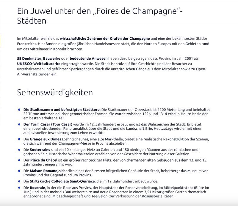
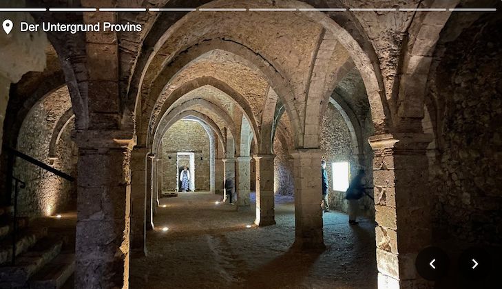
Provins UNESCO-Weltkulturerbe
The medieval fortified town of Provins is located in the Seine-et-Marne department, around 80 km southeast of Paris, and offers an exceptional architectural heritage that bears witness to a past full of trade and lively fairs.
A UNESCO World Heritage Site since 2001, the city, which dates back to the Middle Ages, is full of historical treasures, from the Caesar Tower to the imposing city walls and culinary specialties made from roses!
Seine-et-Marne, Île-de-France, Frankreich
48° 33' 37.1" N 3° 17' 55.7" E
48.5602959 3.2988089
• Head west on Place du Maréchal Leclerc (D403). Go for 19 m.
• Continue on Rue du Val (D403). Go for 49 m.
• Turn left onto Rue des Cordeliers. Go for 78 m.
• Turn left onto Place Honoré de Balzac. Go for 38 m.
• Continue on Rue Vallou de Villeneuve. Go for 51 m.
• Turn right onto Rue Victor Garnier. Go for 120 m.
• Continue on Rue Aristide Briand. Go for 363 m.
• Turn right onto Rue du Canal toward Paris/Marne la Vallée/Bray S/Seine. Go for 364 m.
• Turn right onto Rue Georges Dromigny. Go for 262 m.
• Take the 4th exit from roundabout onto Avenue André Malraux toward Meaux/Marne-la-Vallée/Melun/Paris/Provins-Ville Haute/Cité Médiévale. Go for 286 m.
• Take ramp onto D619. Go for 1.3 km.
• Take the 1st exit from roundabout onto Avenue du Général de Gaulle (D231 A) toward Cité Médiévale. Go for 132 m.
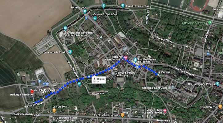
• Turn left onto Chemin de Villecran. Go for 312 m.
• Turn left. Go for 169 m.
• Arrive at your destination on the left.
☍
3,6 km
( 7 min.)
Aire municipal pour Camping-cars
Chemin de Villecran, 77160, Provins, Frankreich
48° 33' 43" N 3° 16' 48" E
48.5619444 3.2800000
• Head northwest. Go for 163 m.
• Turn right onto Vieux Chemin de Paris. Go for 82 m.
• Turn left. Go for 12 m.
• Turn right toward Chemin de Villecran. Go for 161 m.
• Turn right onto Chemin de Villecran. Go for 100 m.
• Arrive at Chemin de Villecran. Your destination is on the left.
☍
0,5 km
( 1 min.)
Chemin de Villecran
Seine-et-Marne, Île-de-France, Frankreich
48° 33' 34.8" N 3° 16' 40.2" E
48.5596719 3.2778461
• Head southwest on Chemin de Villecran. Go for 43 m.
• Continue on Avenue du Général de Gaulle (D231 A). Go for 136 m.
• Take the 2nd exit from roundabout onto D619 toward A5/Paris/Melun/Nangis/Vulaines les P. Go for 18.2 km.
• Take the 2nd exit from roundabout onto Route de Provins (D619). Go for 395 m.
• Turn left toward Melun/Montereau Flt Y./Nangis-Centre. Go for 27 m.
• Continue on Avenue de Verdun (D419). Go for 642 m.
• Take the 2nd exit from roundabout onto Avenue de Verdun (D419) toward Rampillon. Go for 131 m.
• Take the 1st exit from Rond-Point de Valmy roundabout onto Rue de la République. Go for 289 m.
• Turn left onto Rue des Écoles (D56). Go for 75 m.
• Keep right onto Rue des Écoles (D56). Go for 362 m.
• Take the 2nd exit from roundabout onto Route de Montereau (D56) toward Z.A.C. du Chateau. Go for 519 m.
• Turn right onto D201 toward Fontainebleau/Melun. Go for 1.3 km.
• Turn left onto Route de Fontainebleau (D12). Go for 13.5 km.
• Continue on D227 toward D12/Fontainebleau/Pamfou. Go for 322 m.
• Continue on D40 toward Fontainebleau/Machault. Go for 76 m.
• Turn right onto D227 toward Fontainebleau. Go for 6.5 km.
• Continue on D110. Go for 3.5 km.
• Continue on Voie de la Liberté. Go for 352 m.
• Turn left onto Rue du Haut Samoreau (D39 E). Go for 280 m.
• Turn right onto Rue Royale (D210). Go for 359 m.
• Take the 2nd exit from roundabout onto Rue Royale (D210). Go for 619 m.
• Take the 3rd exit from Rond-Point de la Liberté roundabout onto Route de Valvins (D210) toward Fontainebleau/Avon. Go for 1.3 km.
• Take the 2nd exit from roundabout onto Avenue du Général de Gaulle (D210) toward Fontainebleau/Avon-Centre. Go for 2.5 km.
• Turn left onto Rue Grande. Go for 967 m.
• Turn left onto Rue Paul Séramy. Go for 28 m.
• Arrive at Rue Paul Séramy. Your destination is on the right.
☍
52,3 km
( 52 min.)
Day
Day
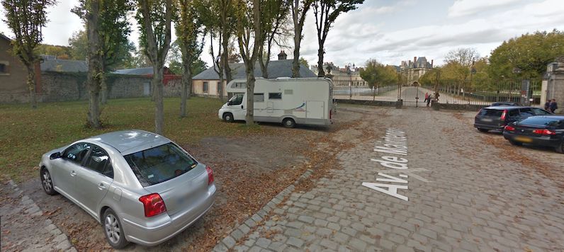
Fontainebleau UNESCO-Weltkulturerbe
Palace and Park of Fontainebleau UNESCO World Heritage Site since 1981
Seine-et-Marne, Île-de-France, Frankreich
48° 24' 17.8" N 2° 42' 5.7" E
48.4049375 2.7015872
• Head toward Rue Grande on Rue Paul Séramy. Go for 28 m.
• Turn left onto Rue Grande. Go for 185 m.
• Continue on Rue Dénecourt. Go for 168 m.
• Turn left. Go for 12 m.
• Arrive at your destination.
☍
0,4 km
( 1 min.)
Day
Besichtigung Château de Fontainebleau
Rue Denecourt, Fontainebleau, Seine-et-Marne, Île-de-France, Frankreich
48° 24' 7.6" N 2° 41' 59.5" E
48.4021167 2.6998510
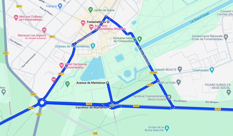
• Head toward Rue Dénecourt. Go for 12 m.
• Turn left onto Rue Dénecourt. Go for 87 m.
• Continue on Place du Général de Gaulle. Go for 26 m.
• Turn left onto Boulevard de Magenta (D417). Go for 664 m.
• Take the 2nd exit from Carrefour de l'Obélisque roundabout onto Route d'Orléans (D152) toward Orléans/Malesherbes/Ury. Go for 24.6 km.
• Continue on Rue Adolphe Cochery (D2152). Go for 2.2 km.
• Pass 2 roundabouts and continue on D2152. Go for 14.9 km.
• Take the 1st exit from roundabout onto D928 toward A19/Orléans. Go for 1.6 km.
• Take the 4th exit from Rond-Point George Stephenson roundabout onto D928 toward A19/Orléans. Go for 595 m.
• Take the 2nd exit from Rond-Point des Droits de l'Homme roundabout onto D928 toward A19/Orléans. Go for 2.3 km.
• Take the 2nd exit from roundabout onto D1950 toward A19/Orléans/Sully S/L./Montargis. Go for 152 m.
• Continue on D928. Go for 652 m.
• Continue on D1950. Go for 46 m.
• Continue on D928. Go for 373 m.
• Take the 2nd exit from roundabout onto D2152 toward Orléans. Go for 4.5 km.
• Pass 2 roundabouts and continue on D2152. Go for 7.8 km.
• Turn left onto Route de Gallerand (D109) toward Courcy aux L./Château de Chamerolles/Gallerand. Go for 2.5 km.
• Arrive at Route de Gallerand (D109). Your destination is on the right.
☍
63,2 km
( 54 min.)
Day
Day
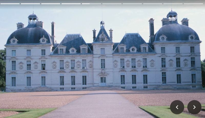
Château de Chamerolles
Route de Gallerand, Chilleurs-aux-Bois, Loiret, Zentrum, Frankreich
48° 3' 37" N 2° 9' 49.4" E
48.0602817 2.1637263
• Head east on Route de Gallerand (D109). Go for 181 m.
• Turn right toward Route de Gallerand/D109. Go for 325 m.
• Turn left onto Route de Gallerand (D109). Go for 2.8 km.
• Turn left onto Grande Rue (D2152). Go for 10.1 km.
• Pass 4 roundabouts and continue on Route Nationale (D2152). Go for 8.5 km.
• Take the 3rd exit from roundabout onto Route de Pithiviers (D2152) toward St Jean de Braye. Go for 944 m.
• Pass 2 roundabouts. Go for 856 m.
• Take ramp onto D2060. Go for 3.7 km.
• Take ramp toward Vierzon/Orléans-Centre/Orléans-la Source/Orléans-La Fontaine/P+R Droits de l'Homme. Go for 175 m.
• Take the 3rd exit from roundabout onto Avenue des Droits de l'Homme toward Vierzon/Orléans-Centre/Orléans-la Source/Orléans-La Fontaine. Go for 1.2 km.
• Pass 2 roundabouts and continue on Avenue des Droits de l'Homme. Go for 1.3 km.
• Continue on Avenue Jean Zay. Go for 974 m.
• Continue on Avenue Jean Zay (D97) toward Paris/Blois/Orléans-Centre/Gare S.N.C.F. d'Orléans. Go for 578 m.
• Turn left onto Esplanade du Souvenir Français toward St Jean de Braye/Centre Ville/Cathédrale. Go for 64 m.
• Turn slightly right onto Place Halma Grand. Go for 218 m.
• Turn right onto Rue Paul Fourche. Go for 43 m.
• Arrive at Rue Paul Fourche. Your destination is on the left.
☍
31,8 km
( 33 min.)
Day
Day
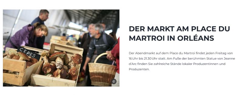
Orléans, Frankreich
47° 54' 10.7" N 1° 54' 33.3" E
47.9029640 1.9092510
• Head toward Rue Théophile Chollet on Rue Paul Fourche. Go for 41 m.
• Keep left onto Rue d'Escures. Go for 227 m.
• Continue on Place du Martroi. Go for 81 m.
• Turn left onto Place du Martroi. Go for 44 m.
• Continue on Rue Charles Sanglier. Go for 89 m.
• Turn right onto Rue Jeanne d'Arc. Go for 118 m.
• Turn left onto Place du Général de Gaulle. Go for 58 m.
• Continue on Rue du Cheval Rouge. Go for 199 m.
• Continue on Rue Gabriel Templier. Go for 110 m.
• Turn right onto Quai Cypierre (D2152). Go for 2.0 km.
• Turn right onto Rue Mothiron toward Madeleine. Go for 156 m.
• Turn left onto Rue de la Madeleine. Go for 95 m.
• Turn left onto Rue Mothiron. Go for 11 m.
• Turn left. Go for 83 m.
• Turn right. Go for 77 m.
• Arrive at your destination on the right.
☍
3,4 km
( 9 min.)
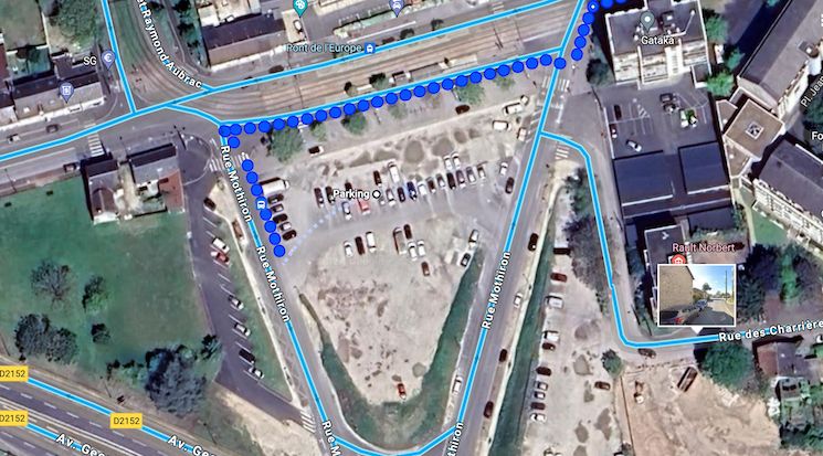
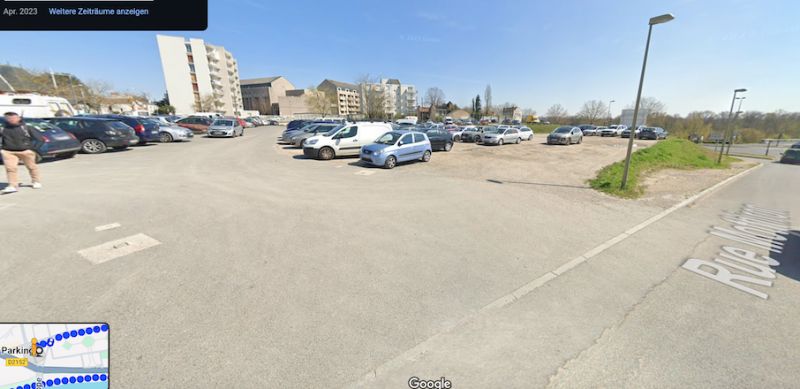
Parkplatz, 117 Rue du Faubourg Madeleine, Orléans, Frankreich
alternative free parking at Pont de l'Europe tram station
117 Rue du Faubourg Madeleine, 45000 Orléans, Frankreich
47° 53' 54.9" N 1° 52' 35.4" E
47.8985695 1.8764921
• Head south. Go for 168 m.
• Turn left. Go for 16 m.
• Turn right toward Rue Mothiron. Go for 7 m.
• Turn left onto Rue Mothiron. Go for 15 m.
• Turn left onto Rue de la Madeleine. Go for 248 m.
• Keep left onto Avenue Georges Clemenceau (D2152). Go for 1.9 km.
• Pass 2 roundabouts and continue on Route d'Orléans (D2152). Go for 865 m.
• Turn left onto Rue de Verdun. Go for 288 m.
• Turn right onto Rue du Four. Go for 81 m.
• Turn left onto Rue du Château. Go for 129 m.
• Continue on Chemin de Fourneaux. Go for 58 m.
• Turn right onto Chemin de Fourneaux. Go for 76 m.
• Arrive at Chemin de Fourneaux. Your destination is on the left.
☍
3,9 km
( 8 min.)
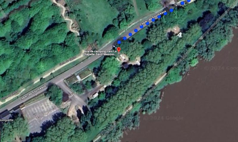
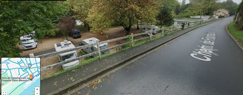
Aire de Camping cars La chapelle Saint Mesmin [AIREPARK], La Chapelle-Saint-Mesmin, Frankreich
according to Google:
a month agoSuper cute parking space right on the Loire with lots of beautiful trees (be careful, it's shady and for those who care: very poor to no satellite reception! 😉). The parking space is quite compact, which means you should be able to drive with a larger vehicle. I would recommend the space up to a maximum of 8.50 m! We have 8.30 m, so the height of 3.65 m was the bigger problem.😉 Access is easy and cashless via a terminal, the streets that lead to the parking space are sometimes very narrow (especially when there are cars parked there...)! I can't say anything about any sanitary facilities as we don't need any. It's about 6 km from the site to the old town of Orleans, easy to cycle back - but it's better to take the illuminated main road when you're back in the dark and not rely on Google Maps, otherwise you'll be driving in pitch darkness or suddenly find yourself in front of a steep staircase!🫣
2 months agoBeautiful, quiet parking spot by the water. Electricity, water, disposal on site. 11.20 including tourist tax. Cycle along the water to Orleans, about 5km. Great.
45380 La Chapelle-Saint-Mesmin, Frankreich
47° 53' 8.2" N 1° 50' 25.6" E
47.8856124 1.8404347
• Head northeast on Chemin de Fourneaux. Go for 76 m.
• Turn left onto Chemin de Fourneaux. Go for 58 m.
• Turn right onto Rue du Petit Château. Go for 162 m.
• Continue on Place de l'Église. Go for 33 m.
• Continue on Rue de l'Église. Go for 41 m.
• Continue on Place du Bourg. Go for 25 m.
• Turn left onto Place du Bourg. Go for 60 m.
• Turn right onto Rue de la Bredauche. Go for 374 m.
• Turn left onto Rue Nationale (D2152). Go for 3.0 km.
• Pass 3 roundabouts and continue on Rue d'Orléans (D2152). Go for 11.3 km.
• Take the 3rd exit from roundabout onto D2152 toward Blois/Beaugency/Baule. Go for 481 m.
• Pass 2 roundabouts and continue on Avenue d'Orléans (D2152). Go for 6.0 km.
• Turn right onto Avenue de Vendôme (D917) toward Villorceau/Josnes/Vendôme/Gare/Hôpital/Château de Talcy. Go for 151 m.
• Turn left onto Rue des Toits. Go for 31 m.
• Continue on Rue de la Gare. Go for 58 m.
• Turn right onto Rue de la Gare. Go for 42 m.
• Turn right. Go for 12 m.
• Arrive at your destination on the right.
☍
21,8 km
( 28 min.)
Day
Day
Day
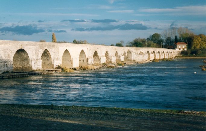
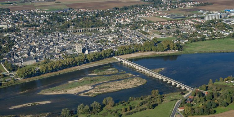
Beaugency
On the right bank of the Loire, the town of Beaugency boasts a 12th-century bridge, unusual because each of its 23 arches has a different style. The heart of the town is an archaeological garden called the City of Lords, named after the counts who enjoyed great power in the Middle Ages. A major medieval event took place here: in 1152, the marriage of Eleanor of Aquitaine and her cousin Louis VII was annulled. She then married Henry II of England, bringing southwest France as a dowry, an act that sparked the Hundred Years' War. This remarkable woman was the mother of Richard the Lionheart
The Beaugency Bridge was already fiercely contested during the Franco-Prussian War of 1870/71.
During World War II, the German Air Force bombed the city twice (1940 and 1944).
On September 16, 1944, German General Botho Henning Elster, along with 18,850 soldiers and 754 officers, formally surrendered to US General Robert C. Macon of the 83rd Infantry Division on the Loire Bridge at Beaugency.
Rue des Acacias, Beaugency, Loiret, Zentrum, Frankreich
47° 46' 42.4" N 1° 37' 32.8" E
47.7784476 1.6257772
• Head toward Rue de la Gare. Go for 12 m.
• Turn left onto Rue de la Gare. Go for 42 m.
• Turn right onto Rue de la Gare. Go for 140 m.
• Turn left onto Rue Nationale (D2152). Go for 548 m.
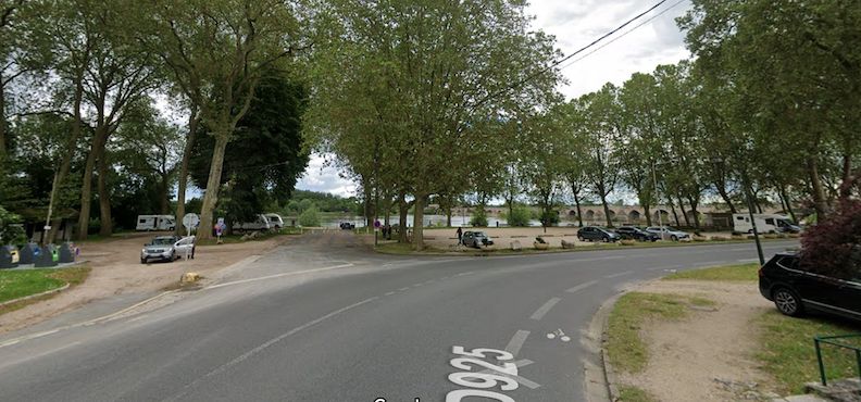
• Turn right onto Avenue de Chambord (D925) toward Lailly en Val/Olivet/La Ferté St Aubin/Château Abbatiale/Pont sur la Loire/Centre Ville. Go for 314 m.
• Turn left onto Rue des Îles. Go for 33 m.
• Arrive at Rue des Îles. Your destination is on the right.
☍
1,1 km
( 2 min.)
Aire de Camping-cars, Rue des Îles
Rue des Îles 7, Beaugency, Loiret, Zentrum, Frankreich
47° 46' 47.9" N 1° 38' 10.8" E
47.7799630 1.6363370
• Head toward Avenue de Chambord on Rue des Îles. Go for 33 m.
• Turn left onto Avenue de Chambord (D925). Go for 8 m.
• Turn left onto Quai Dunois. Go for 81 m.
• Arrive at Quai Dunois.
☍
0,1 km
( )
Aire de Camping-cars
Free parking space for 10 mobile homes, on a separate site directly on the banks of the Loire. Natural, not entirely level ground under tall trees. Scenic, relatively quiet location. Boules court adjacent. Information board and toilet block available. Can be used all year round.
Quai Dunoise, 45190, Beaugency, Frankreich
47° 46' 45" N 1° 38' 13" E
47.7791667 1.6369444
• Head northwest on Quai Dunois. Go for 81 m.
• Turn sharp left onto Quai Dunois (D925). Go for 244 m.
• Turn left onto Rue du Pont (D925). Go for 470 m.
• Turn right onto Lieu-dit Le Bout du Pont (D925). Go for 4.0 km.
• Turn right onto Route de Beaugency. Go for 1.2 km.
• Continue on Lieu-dit La Motte Pintenas. Go for 437 m.
• Turn right onto D951. Go for 1.6 km.
• Continue on Avenue de Sologne. Go for 1.3 km.
• Take the 2nd exit from Route de Blois roundabout onto Route de Blois (D951). Go for 5.3 km.
• Turn left onto D112 B. Go for 2.5 km.
• Turn slightly left onto D112. Go for 2.9 km.
• Pass 2 roundabouts and continue on D112. Go for 2.9 km.
• Turn left onto D33. Go for 632 m.
• Turn left onto Rue de la Grange aux Dîmes. Go for 113 m.
• Arrive at Rue de la Grange aux Dîmes. Your destination is on the left.
☍
23,7 km
( 24 min.)
Day
Day
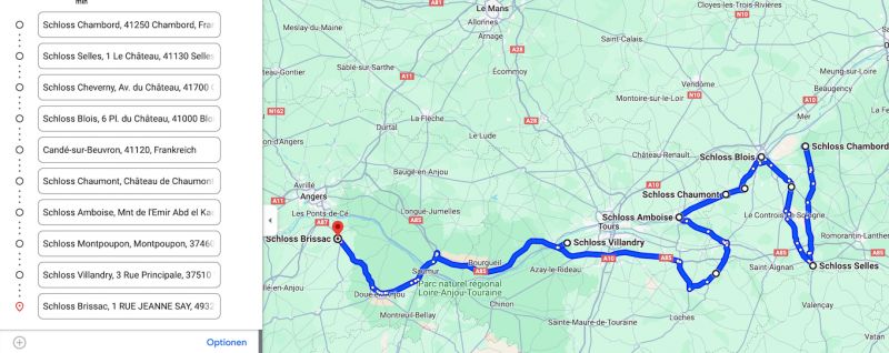
UNESCO-Weltkulturerbe Loire
Wegstrecke von Chambord über Cheverny nach Bloisnach
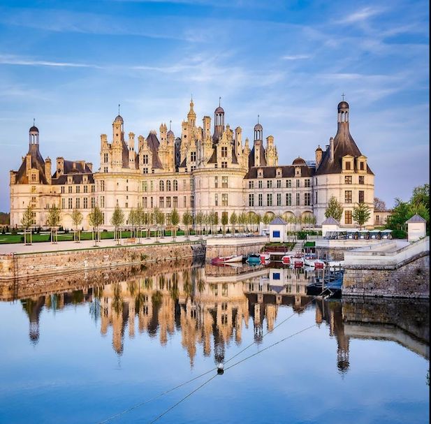
Chambord, Frankreich
UNESCO World Heritage Site
Loire Valley between Maine and Sully-sur-Loire - with the Castle of Chambord (2000)
The Château de Chambord was built in the Italian Renaissance style like a medieval fortress in the 16th century.
With its decorative elements, this architectural masterpiece embodies the transition from the Middle Ages to the Renaissance.
41250 Chambord, Frankreich
47° 36' 51" N 1° 31' 0.8" E
47.6141580 1.5168780
• Head toward Route de la Commission on Rue de la Grange aux Dîmes. Go for 113 m.
• Turn right onto Route de la Commission (D33). Go for 632 m.
• Turn right onto D112. Go for 160 m.
• Turn right onto Place Saint-Louis. Go for 192 m.
• Turn left. Go for 24 m.
• Arrive at your destination.
☍
1,1 km
( 2 min.)
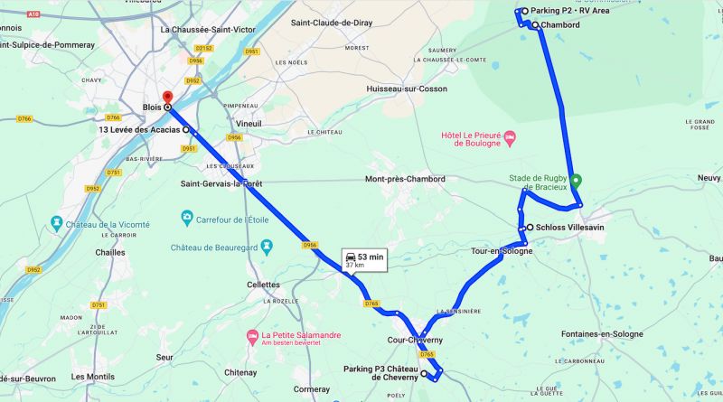
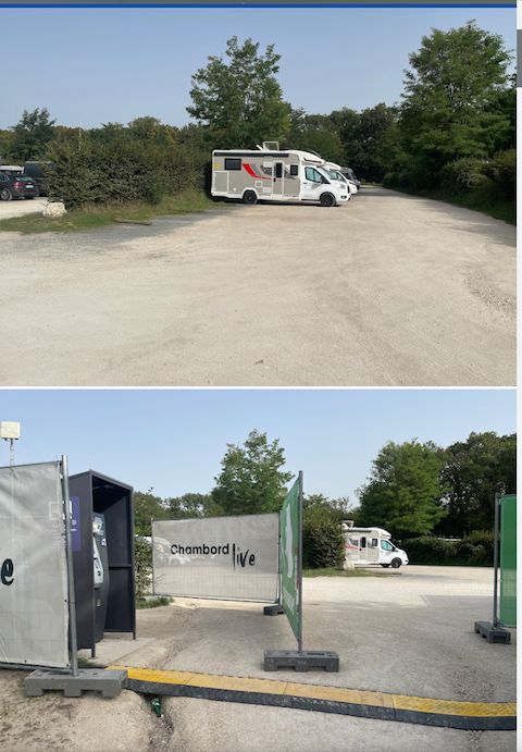
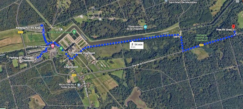
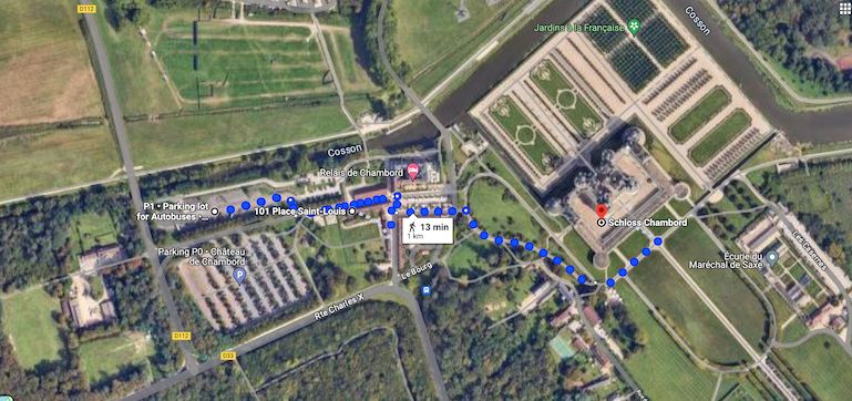
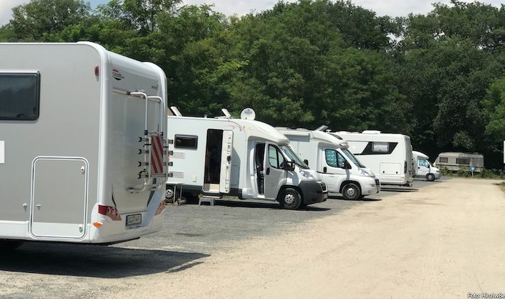
Parkplatz Parking P2 • RV Area für Wohnmobile
According to Promobil:
Paid parking space for 100 mobile homes on the outskirts of Chambord. The parking space is located in a car park and in an area designed and designated for mobile homes.
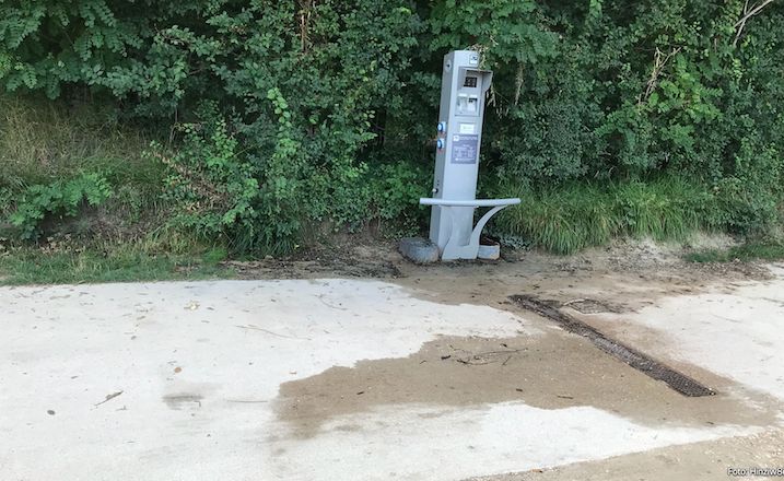
Mostly flat, partially shady site. Paved and gravelled surface. On site: restaurant, kiosk, e-bike rental, fresh water. Nearby: castle/fortress, designated cycling and hiking trails. Price per night: 11 euros. Payment: parking ticket machine. Disposal of grey water, dogs included in the overnight price.
P2: It costs 12 euros for the day, which isn't exactly cheap, but it's worth it. Super quiet night, the evening walk is very relaxing. Lots of paths that are perfect for walking with your dog.
a month ago12€/24h - Pleasant campsite, the pitches are functional, the toilets are clean (dry toilets + paper + disinfectant). The setting is perfect for moments of relaxation before or after visiting the castle.
Parking Château Chambord
according to Promobil:
Paid parking space for 100 mobile homes on the outskirts of Chambord. The parking space is located in a car park and in an area designed and designated for mobile homes. Mostly flat, partially shaded area. Paved and gravelled surface. On site: restaurant, kiosk, e-bike rental, fresh water. Nearby: castle/fortress, designated cycling and hiking trails. Price per night: 11 euros. Payment: parking ticket machine. Disposal of gray water, dogs included in the overnight price.
Place St. Louis, 41250, Chambord, France
47° 36' 58" N 1° 30' 42" E
47.6161111 1.5116667
• Head toward Place Saint-Louis. Go for 24 m.
• Turn right onto Place Saint-Louis. Go for 192 m.
• Turn left onto D112. Go for 160 m.
• Turn left onto D33. Go for 809 m.
• Continue on Route de Bracieux (D112). Go for 6.8 km.
• Take the 2nd exit from roundabout onto Rue Roger Brun (D923). Go for 282 m.
• Take the 3rd exit from roundabout onto Rue Roger Brun (D923). Go for 8.4 km.
• Turn left onto Avenue de Verdun. Go for 413 m.
• Take the 2nd exit from roundabout onto Avenue du 11 Novembre. Go for 34 m.
• Continue on Boulevard Munier. Go for 162 m.
• Turn left onto Avenue de la République. Go for 91 m.
• Turn left onto Rue Nationale (D102). Go for 271 m.
• Take the 1st exit from roundabout onto Avenue du Château (D102). Go for 830 m.
• Turn left onto Route du Bûcher. Go for 122 m.
• Turn right. Go for 43 m.
• Arrive at your destination.
☍
18,6 km
( 22 min.)
Day
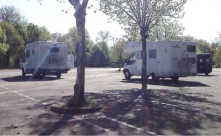
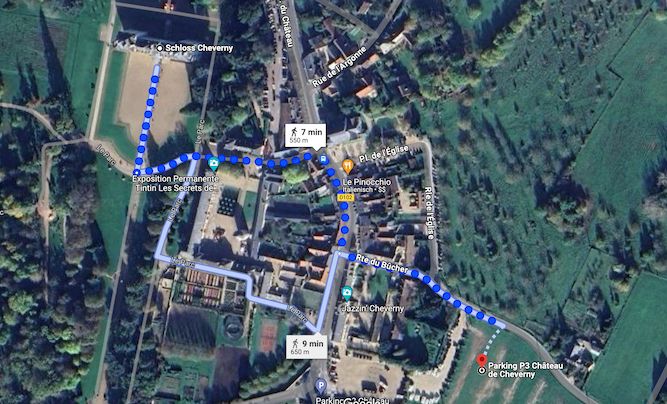
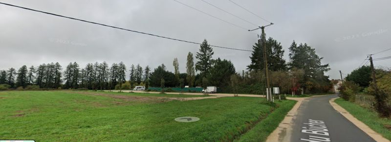
Aire Château de Cheverny
According to Promobil:
Free parking space for 15 mobile homes on the outskirts of Cheverny. The parking space is in a car park. Mostly flat ground, no shade. Gravel surface with grass. Center can be reached on foot. On site: dogs allowed. Nearby: castle/fortress, park.
a month ago
Very new parking lot for motorhomes with disposal facility
a week ago
NEW June 2024: Excellent open space for motorhomes. Clean, rocky, shade will come when the planted trees have grown a little ... (it's brand new) The castle that served as a model for Hergé to design Moulinsart is 300m away. Pinocchio, the best pizzeria in the world is 400m away, enjoy it!
Route du Bucher, Cheverny, Loir-et-Cher, Zentrum, Frankreich
47° 29' 51.9" N 1° 27' 41.2" E
47.4977455 1.4614356
• Head south. Go for 74 m.
• Turn left toward Rue du Chêne des Dames/D102. Go for 77 m.
• Take the 2nd exit from roundabout onto Rue du Chêne des Dames (D102). Go for 231 m.
• Take the 1st exit from roundabout. Go for 349 m.
• Arrive at your destination on the left.
☍
0,7 km
( 2 min.)
Château de Cheverny
The Château de Cheverny has the most beautiful and magnificent interior of all the Loire châteaux.
The castle has been owned by the same family for 6 centuries
Avenue du Château, Cheverny, Loir-et-Cher, Zentrum, Frankreich
47° 30' 0.8" N 1° 27' 28.9" E
47.5002311 1.4580181
• Head toward Lieu-dit Bel Air. Go for 344 m.
• Take the 3rd exit from roundabout onto Route de Cheverny (D102). Go for 219 m.
• Take the 3rd exit from roundabout onto Rue du Chêne des Dames (D102). Go for 969 m.
• Take the 2nd exit from roundabout onto Avenue du Château (D102). Go for 76 m.
• Turn right onto Rue Fourche. Go for 98 m.
• Turn right onto Rue Gilette. Go for 162 m.
• Take the 3rd exit from roundabout onto Avenue du 11 Novembre (D765). Go for 1.4 km.
• Take the 2nd exit from roundabout onto D765. Go for 4.0 km.
• Continue on D956. Go for 3.7 km.
• Take the 3rd exit from La Patte d'Oie roundabout onto Route Nationale (D956 B) toward St Gervais la Forêt/Blois/P.A. Sud-les Clouseaux/P.A. Sud-les Perrières. Go for 2.7 km.
• Take the 2nd exit from roundabout onto Avenue du Président Wilson (D956 B) toward Le Château/Blois-Sud/Z.A. Croix Boissée. Go for 1.4 km.
• Arrive at Place de la Résistance (D956 B). Your destination is on the left.
☍
15,0 km
( 18 min.)
Day
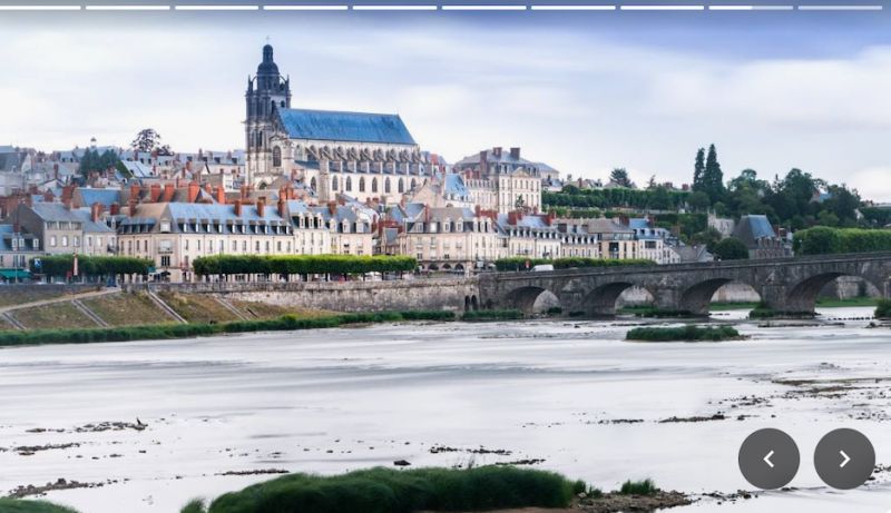
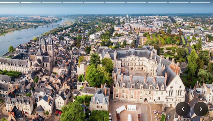
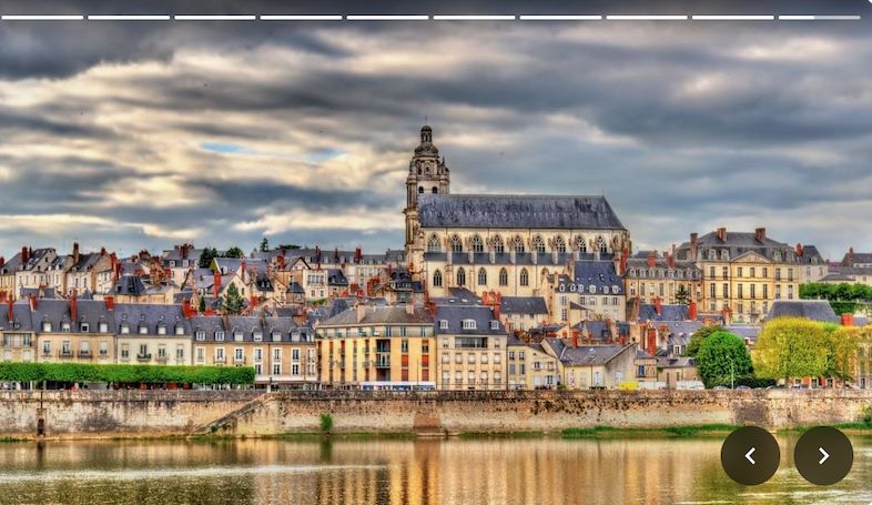
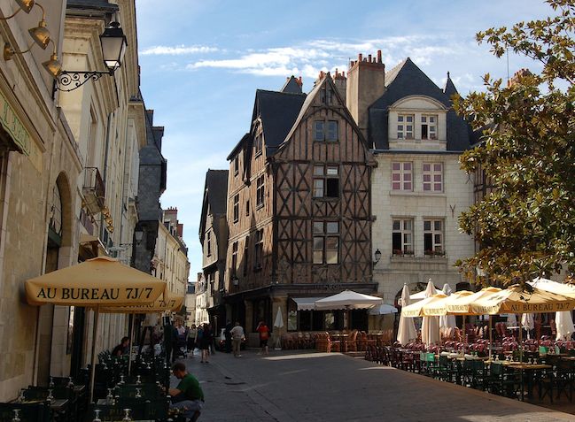
Blois, Frankreich
Blois Castle (French: Château Royal de Blois) is one of the castles of the Loire. It stands on a mountain spur on the right bank of the Loire in the French city of Blois in the Loir-et-Cher department. Because it was the residence of the French kings under the French ruling houses of Valois and Orléans from 1498 to 1589 and combines buildings from four eras in one complex, it is one of the most famous Loire castles.
Built in the 10th century by the Counts of Blois as a fortified tower on a rocky plateau, it was gradually expanded into a castle complex by the 13th century. The last Count of Blois sold it to the Valois ruling dynasty at the end of the 14th century.
The kings Louis XII and Francis I used the buildings as their main residence and had numerous renovations and extensions carried out. The last structural changes to the castle were made in the 17th century according to plans by the architect François Mansart, but after that it gradually sank into insignificance.
After the buildings were plundered and damaged during the French Revolution, they were extensively restored from 1845 onwards. Blois Castle was thus the first Loire castle to be restored after the Revolution and served as a model for the restoration of almost all of the castles in the Loire Valley known today, such as Azay-le-Rideau Castle, Chenonceau Castle and Amboise Castle. Since then, it has been used as a museum.
41000 Blois, Frankreich
47° 35' 9.9" N 1° 20' 9.4" E
47.5860921 1.3359475
• Head toward Rue Henri Drussy on Place de la Résistance (D956 B). Go for 11 m.
• Turn left onto Rue Émile Laurens. Go for 18 m.
• Turn right onto Place de la Résistance. Go for 21 m.
• Turn right onto Place de la Résistance (D956 B). Go for 990 m.
• Turn right onto Levée des Acacias. Go for 152 m.
• Arrive at Levée des Acacias.
☍
1,2 km
( 2 min.)
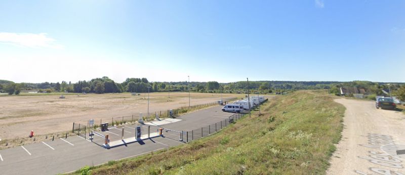
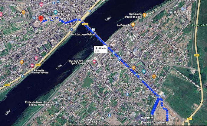
Wohnmobilstellplatz Blois
RV Park19 Levée des Acacias, 41000 Blois, Franceat the Parc des Expositions41000 Blois, France
New parking area for motorhomes. It has all the services to stay in the city of Blois from 2 to 24 hours and more.
Water (2€), wastewater disposal, free WiFi (no electricity).
Video-monitored parking lot, access barrier and emergency intercom system around the clock.
For transport in the city center: bring your bikes or use the free electric downtown shuttle or line A.
Levée des Acacias 13, Blois, Loir-et-Cher, Zentrum-Loiretal, Frankreich
47° 34' 43.7" N 1° 20' 39.3" E
47.5788192 1.3442589
• Head north on Levée des Acacias. Go for 152 m.
• Turn left onto Avenue du Président Wilson (D956 B). Go for 628 m.
• Turn left onto Carrefour de la Libération (D751). Go for 1.5 km.
• Take the 2nd exit from Rond-Point Joseph-Paul Boncour roundabout onto Levée de Chailles (D751) toward Montrichard/Chailles/Chaumont S/L./Amboise. Go for 3.3 km.
• Turn right onto D173. Go for 2.5 km.
• Continue on Lieu-dit L'Orme Cochard (D173). Go for 69 m.
• Continue on D173. Go for 1.5 km.
• Continue on Lieu-dit La Clémandière (D173). Go for 91 m.
• Continue on D173. Go for 1.4 km.
• Continue on Lieu-dit La Gaillardière (D173). Go for 128 m.
• Continue on D173. Go for 1.6 km.
• Continue on Lieu-dit Les Terres de la Borde (D173). Go for 16 m.
• Continue on D173. Go for 399 m.
• Continue on Rue du Château (D173). Go for 719 m.
• Turn right onto D751. Go for 437 m.
• Turn left onto Route de Pontlevoy. Go for 143 m.
• Arrive at Route de Pontlevoy. Your destination is on the left.
☍
14,5 km
( 15 min.)
Day
Day
Day
Day
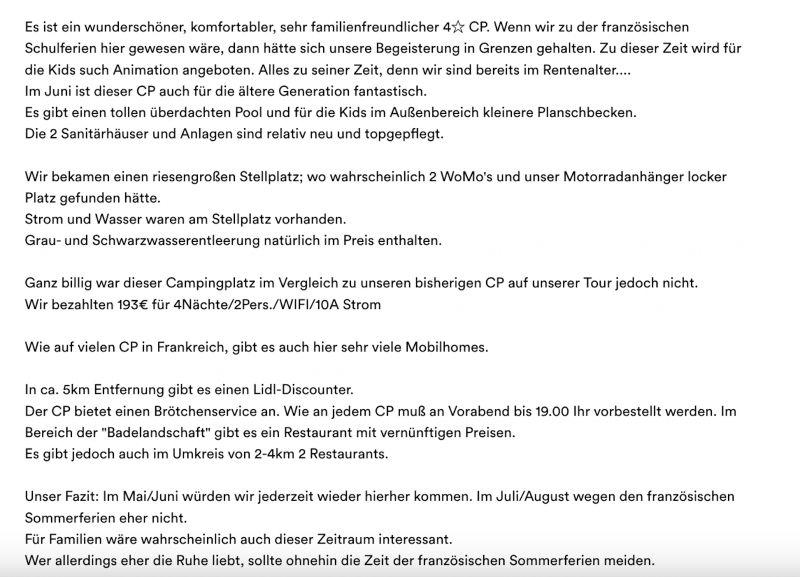
Camping La Grande Tortue
3, route de pontlevoy, 41120, Cande sur Beuvron, Frankreich
47° 29' 22.3" N 1° 15' 30" E
47.4895200 1.2583400
• Head north on Route de Pontlevoy. Go for 143 m.
• Turn left onto D751. Go for 5.1 km.
• Turn right onto Rue du Passeur. Go for 183 m.
• Turn right onto Chemin du Camping. Go for 271 m.
• Turn left. Go for 32 m.
• Arrive at your destination on the right.
☍
5,8 km
( 6 min.)
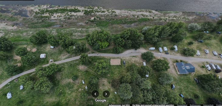
Camping Municipal
Chaumont-sur-Loire
Supply and disposal at the local campsite; approx. 500 meters
Address
Location: Chaumont-sur-Loire
Street: Loire river bank, in front of the campsite
Postcode: F - 45110. The motorhome parking space in Chaumont-sur-Loire is located on the banks of the Loire within walking distance of the castle. The parking space can also be accessed by heavy motorhomes. There is no motorhome infrastructure at the site itself.
However, supply and disposal is possible at the nearby campsite.
41150, Chaumont Sur Loire, Frankreich
47° 29' 5.9" N 1° 11' 40.6" E
47.4849700 1.1946000
• Head toward Chemin du Camping. Go for 32 m.
• Turn right onto Chemin du Camping. Go for 271 m.
• Turn left onto Rue du Passeur. Go for 183 m.
• Turn right onto Rue du Maréchal Leclerc (D114). Go for 288 m.
• Continue on Rue du Maréchal de Lattre de Tassigny (D751). Go for 734 m.
• Turn left onto Rue de l'Aumône. Go for 23 m.
• Turn slightly left onto Rampe du Château. Go for 88 m.
• Arrive at Rampe du Château. Your destination is on the left.
☍
1,6 km
( 3 min.)
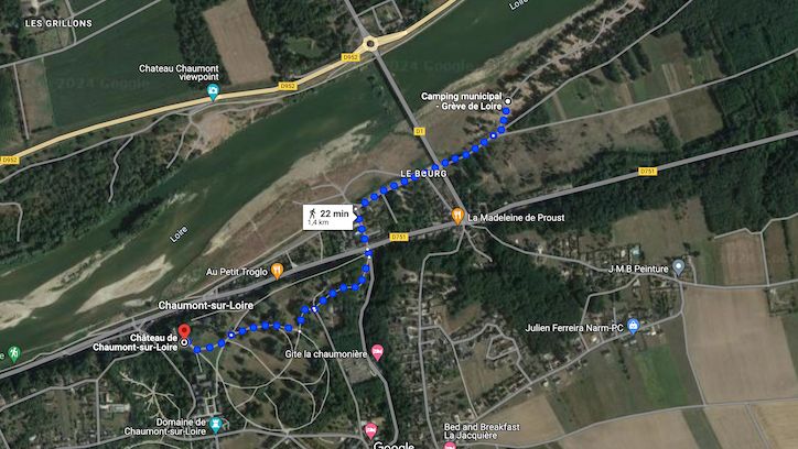
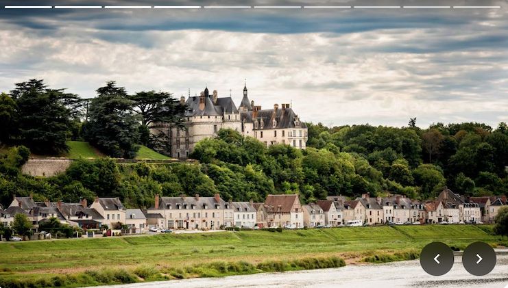
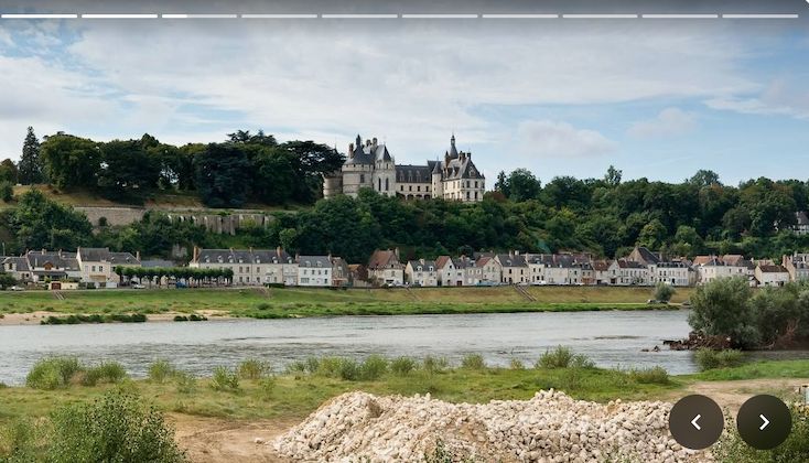
Château de Chaumont-sur-Loire
Chaumont Castle is located southwest of the city of Blois in the French commune of Chaumont-sur-Loire in the Loir-et-Cher department in the Centre-Val de Loire region. Perched on a steep slope high above the Loire, it forms the backdrop to the village, whose houses line the river bank in a long row.
Despite the open north side, Chaumont Castle gives the typical impression of a late stately fortress. The oldest parts are the north wing, which has now disappeared, as well as the west wing, the large Amboise Tower and the first adjoining vaulted area of the south wing. Everything shows a Gothic defensive style typical of the 15th century, with battlements, machicolations, drawbridge and dry moat.
The fortress of Chaumont Chaumont sur Loire was built around the year 1000.
After its destruction, the castle was rebuilt in Renaissance style in 1465.
A so-called "English Garden" characterizes the image of the castle park.
Rampe du Château, Chaumont-sur-Loire, Loir-et-Cher, Zentrum, Frankreich
47° 28' 44.9" N 1° 10' 53.5" E
47.4791460 1.1815237
• Head toward Rue des Argillons on Rampe du Château. Go for 315 m.
• Turn left onto Rue des Argillons. Go for 74 m.
• Turn right. Go for 111 m.
• Turn right. Go for 17 m.
• Arrive at your destination on the left.
☍
0,5 km
( 1 min.)
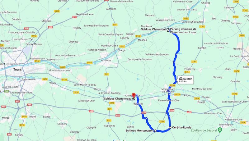
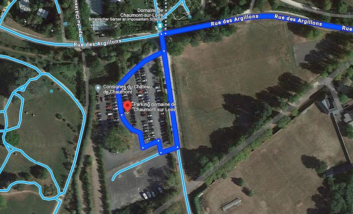
Parking domaine de Chaumont sur Loire
Rue des Argillons, Chaumont-sur-Loire, Loir-et-Cher, Zentrum-Loiretal, Frankreich
47° 28' 31.7" N 1° 10' 59.8" E
47.4754808 1.1832682
• Head east. Go for 17 m.
• Turn right toward Lieu-dit Le Queneau. Go for 249 m.
• Continue on Lieu-dit Le Queneau. Go for 635 m.
• Turn right onto D27. Go for 3.5 km.
• Continue on Lieu-dit La Fumardière (D27). Go for 60 m.
• Continue on D27. Go for 498 m.
• Continue on Route de Chaumont (D27). Go for 1.4 km.
• Continue on Route de Chaumont (D27). Go for 684 m.
• Take the 2nd exit from roundabout onto Avenue de Verdun (D27). Go for 262 m.
• Continue on Place de l'Église (D27/D30). Go for 37 m.
• Turn left onto Route de Montrichard (D27). Go for 889 m.
• Continue on D27. Go for 92 m.
• Turn right onto D27. Go for 550 m.
• Continue on Lieu-dit La Hutterie (D27). Go for 309 m.
• Continue on D27. Go for 2.6 km.
• Continue on Lieu-dit La Closerie (D27). Go for 156 m.
• Continue on Lieu-dit La Guillotière (D27). Go for 232 m.
• Continue on D27. Go for 3.0 km.
• Turn left onto Route d'Amboise (D115). Go for 55 m.
• Turn right onto D27. Go for 489 m.
• Continue on Lieu-dit La Bourde (D27). Go for 128 m.
• Continue on D27. Go for 239 m.
• Continue on Rue Basse (D27). Go for 1.2 km.
• Take the 2nd exit from roundabout onto Rue Basse (D27). Go for 527 m.
• Continue on Rue de la Gare (D27). Go for 332 m.
• Continue on D27. Go for 320 m.
• Continue on Rue de la France Libre (D27). Go for 249 m.
• Take the 1st exit from roundabout onto D976 toward A85/Tours/Bléré. Go for 3.7 km.
• Take the 1st exit from roundabout onto D80 toward Chisseaux/Chenonceaux. Go for 392 m.
• Turn left. Go for 1.1 km.
• Arrive at your destination on the right.
☍
23,9 km
( 26 min.)
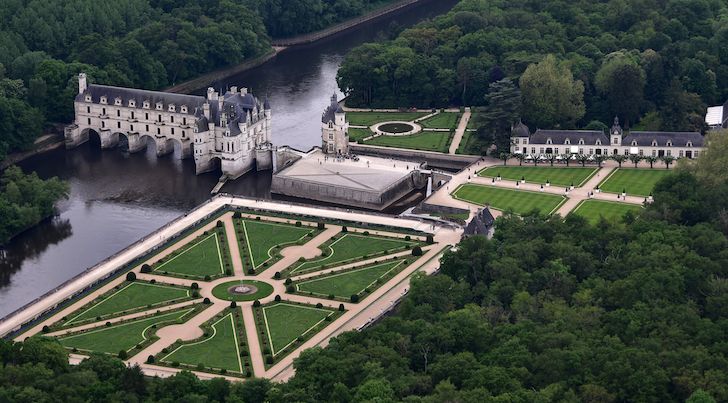
Schloss Chenonceau
Avant Cour, Chenonceaux, Indre-et-Loire, Zentrum-Loiretal, Frankreich
47° 19' 29.4" N 1° 4' 13.7" E
47.3248335 1.0704792
• Head northeast. Go for 1.1 km.
• Turn left onto D80. Go for 334 m.
• Continue on Rue de la Gare (D80). Go for 343 m.
• Turn left onto Rue de l'Europe (D40). Go for 1.1 km.
• Turn left onto Rue du Château. Go for 75 m.
• Arrive at Rue du Château.
☍
2,9 km
( 6 min.)
Chenonceau Castellum, Rue du Château, Chenonceaux, Frankreich
Chenonceaux Castle is a moated castle.
It is privately owned by the Menier family of chocolate manufacturers.
Built in the 13th century as a medieval castle, the new construction of the palace (in early Renaissance form) began in 1515.
Entrance fee approx. 17€
Rue du Château, 37150 Chenonceaux, Frankreich
47° 19' 51.9" N 1° 4' 0.5" E
47.3310723 1.0668006
• Head southwest on Rue du Château. Go for 60 m.
• Turn left onto Chemin de la Varenne. Go for 216 m.
• Turn left toward Rue de la Source. Go for 9 m.
• Continue on Rue de la Source. Go for 8 m.
• Turn right. Go for 80 m.
• Arrive at your destination.
☍
0,4 km
( 1 min.)
Aire Camping-Car Park Chem. de la Varenne, 37150 Chenonceaux,
Everything is GREAT. Access, parking space, 6A electricity, water, waste disposal, access from the castle, don't turn out of the village, Google is wrong there.
You need a card to gain access, but you can get one directly from the machine.
Motorhome parking accessible with "camping parking" pass. The pass can be used for dozens of CCPs, so just add a few dollars. Also indicated in Dutch. Sanitary neat. Wonderfully quiet, every now and then a train passes. The access is indeed very narrow on two sections. We succeeded. Drive very carefully and the passenger gets out, walks ahead and watches. The worst part, the 2nd part, is about 10 meters long and 2.90 meters wide.
Rue de la Fontaine des Prés 1, Chenonceaux, Indre-et-Loire, Zentrum-Loiretal, Frankreich
47° 19' 50.7" N 1° 4' 13.1" E
47.3307564 1.0703011
• Head toward Rue de la Source. Go for 80 m.
• Turn right onto Rue de la Source. Go for 99 m.
• Turn left onto Rue Bretonneau (D40). Go for 1.6 km.
• Turn right onto Rue d'Amboise (D81). Go for 165 m.
• Take the 1st exit from roundabout onto Rue de Bellevue (D81). Go for 40 m.
• Continue on Rue d'Amboise (D81). Go for 2.8 km.
• Continue on D81. Go for 947 m.
• Continue on Route de Civray-de-Touraine (D81). Go for 4.0 km.
• Turn left onto Boulevard Saint-Denis Hors (D31) toward Amboise-Centre/Le Château. Go for 643 m.
• Turn right onto Route de Chenonceaux (D81). Go for 1.1 km.
• Continue on Rue Grégoire de Tours (D81). Go for 787 m.
• Turn left onto Avenue Léonard de Vinci (D61). Go for 232 m.
• Continue on Place Richelieu (D61). Go for 287 m.
• Continue on Rue d'Orange (D61). Go for 80 m.
• Continue on Rue Jean-Jacques Rousseau (D61). Go for 109 m.
• Turn right onto Quai du Général de Gaulle (D751). Go for 38 m.
• Keep left onto Quai du Général de Gaulle (D431). Go for 382 m.
• Turn right onto Quai du Maréchal Foch. Go for 254 m.
• Take the 3rd exit from Place Émile Gounin roundabout onto Allée de la Chapelle Saint-Jean. Go for 831 m.
• Turn right onto Allée de la Chapelle Saint-Jean. Go for 30 m.
• Arrive at Allée de la Chapelle Saint-Jean. Your destination is on the left.
☍
14,5 km
( 19 min.)
Day
Chapelle Saint-Jean
Aire Camping-Car Park All. de la Chapelle Saint-Jean, 37400 Amboise, FranceLt. Promobile:
15 reviews
Paid parking space for 24 mobile homes on the outskirts of Amboise. Mostly flat ground, no shade. Ground with grass. On site: video surveillance, pool/swimming pool, WiFi, dogs allowed.
Nearby: old town, castle, indoor swimming pool, designated cycling and hiking trails.
Price per night including two adults: 10.80 - 12 euros depending on the season. Tourist tax per adult: 55 cents. Payment: operator. Electricity, water, grey water disposal, chemical toilet disposal included in the overnight price.
Maximum stay: 2 nights.
Attention: Access only with a “Pass'Étapes” membership card. Can be ordered for a one-off fee of EUR 5 on the Camping-Car Park website indicated above.
Allée de la Chapelle Saint-Jean, Amboise, Indre-et-Loire, Zentrum, Frankreich
47° 25' 17.5" N 0° 59' 39.3" E
47.4215275 0.9942389
• Head east on Allée de la Chapelle Saint-Jean. Go for 925 m.
• Take the 1st exit from Place Émile Gounin roundabout onto Quai du Maréchal Foch. Go for 273 m.
• Turn left onto Pont Général Leclerc (D431). Go for 571 m.
• Make a U-Turn onto Quai du Général de Gaulle (D751). Go for 200 m.
• Keep right onto Quai du Général de Gaulle (D751). Go for 169 m.
• Turn right onto Rue Louis XII. Go for 39 m.
• Turn left onto Rue de la Concorde. Go for 39 m.
• Arrive at Rue de la Concorde. Your destination is on the right.
☍
2,2 km
( 5 min.)
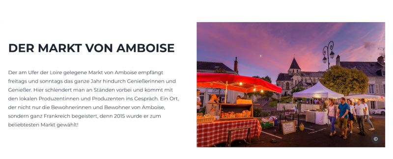
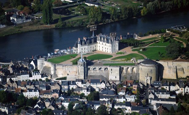
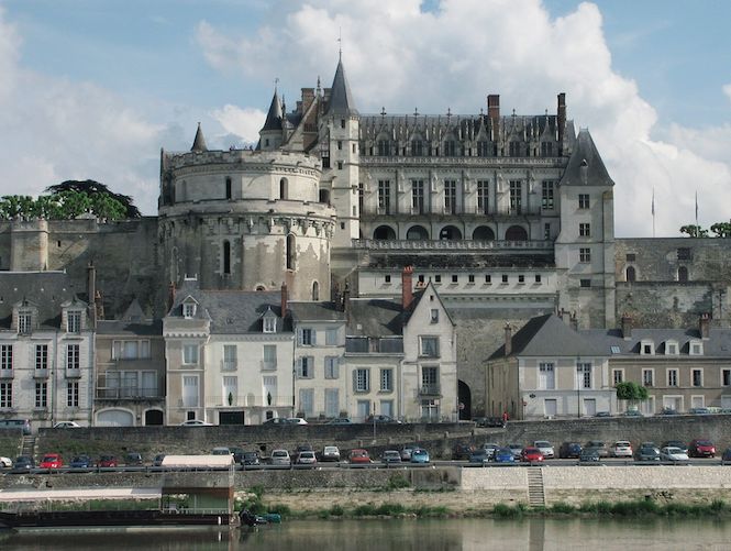
Schloss Amboise
The Château de Amboise was built in the middle of the 15th century on a rocky plateau above Amboise.
From a cultural and historical perspective, it is one of the most important castles in the Loire.
It served as Leonardo da Vinci's sphere of influence and is also his final resting place.
Entrance fee 16.40€
Rue Charles VIII, Amboise, Indre-et-Loire, Zentrum, Frankreich
47° 24' 49.1" N 0° 59' 9.5" E
47.4136291 0.9859719
• Head northeast on Rue de la Concorde. Go for 3 m.
• Turn left onto Rue Charles VIII. Go for 40 m.
• Turn left onto Quai Charles Guinot (D751). Go for 17 m.
• Turn right onto Quai Charles Guinot (D431). Go for 83 m.
• Turn right onto Pont Général Leclerc (D431). Go for 462 m.
• Take the 2nd exit from Rue de Blois roundabout onto Rue de Blois (D952). Go for 14.0 km.
• Take the 2nd exit from roundabout onto Pont Charles de Gaulle (D142) toward Montlouis S/Loire/Tours-Sud. Go for 1.5 km.
• Take the 3rd exit from roundabout onto D751. Go for 1.9 km.
• Take the 2nd exit from roundabout onto Lieu-dit La Boisselière (D751). Go for 5.2 km.
• Take the 2nd exit from Carrefour des Français Libres roundabout onto Avenue Georges Pompidou toward A10/A85/Tours-Sud/C.H.U. Trousseau/St Pierre des Corps. Go for 327 m.
• Take the 2nd exit from roundabout onto Avenue Georges Pompidou toward A10-A85/Tours-Sud. Go for 106 m.
• Take ramp onto A10 (L'Aquitaine) toward A85/Poitiers/Châteauroux/Vierzon/Tours-Sud. Go for 3.0 km.
• Take exit 22 toward Tours-Sud. Go for 466 m.
• Continue on Route de Saint-Avertin (D976). Go for 940 m.
• Take the 1st exit from Carrefour de l'Alouette roundabout onto Avenue de Grammont (D910) toward Centre Ville/Villandry. Go for 257 m.
• Take ramp. Go for 111 m.
• Turn left onto Carrefour du Lac. Go for 74 m.
• Turn left onto Avenue du Général Niessel. Go for 93 m.
• Turn right onto Avenue du Général Niessel. Go for 44 m.
• Arrive at Avenue du Général Niessel. Your destination is on the right.
☍
28,5 km
( 27 min.)
Day
Day
Day
Parking Centre Aquatique du Lac, 10 Avenue du Général Niessel, 37200 Tours, Frankreich
10 Av. du Général Niessel, 37200 Tours, Frankreich
47° 22' 1.1" N 0° 42' 3.9" E
47.3669837 0.7010728
• Head south on Avenue du Général Niessel. Go for 44 m.
• Turn left onto Avenue du Général Niessel. Go for 93 m.
• Turn right onto Carrefour du Lac. Go for 74 m.
• Take ramp onto Avenue de Grammont (D910). Go for 920 m.
• Take the 2nd exit from Carrefour de Verdun roundabout onto Avenue de Grammont (D910) toward Centre Ville. Go for 534 m.
• Turn right onto Rue du Sanitas. Go for 120 m.
• Arrive at Rue du Sanitas. Your destination is on the right.
☍
1,8 km
( 3 min.)
Avenue Saint-Lazare
Parking Saint-Paul 1 Av. Saint-Lazare, 37000 Tours, France
Large parking lot about 450 m from the Charcot tram stop
Indre-et-Loire, Zentrum, Frankreich
47° 22' 40.9" N 0° 41' 42.6" E
47.3780231 0.6951732
• Head east on Rue du Sanitas.
• Turn left onto Avenue Saint-Lazare. Go for 222 m.
• Turn left onto Avenue du Général de Gaulle. Go for 141 m.
• Take the 2nd exit from roundabout onto Avenue de Grammont (D910). Go for 1.0 km.
• Turn right onto Place Jean Jaurès. Go for 133 m.
• Turn right onto Place Jean Jaurès. Go for 62 m.
• Make a U-Turn onto Boulevard Heurteloup. Go for 128 m.
• Continue on Boulevard Béranger. Go for 302 m.
• Turn right onto Rue de la Grandière. Go for 261 m.
• Turn right onto Rue Néricault Destouches. Go for 163 m.
• Turn right onto Rue Marceau. Go for 168 m.
• Turn left onto Rue Étienne Pallu. Go for 183 m.
• Continue on Rue des Minimes. Go for 43 m.
• Arrive at Rue des Minimes. Your destination is on the left.
☍
2,8 km
( 7 min.)
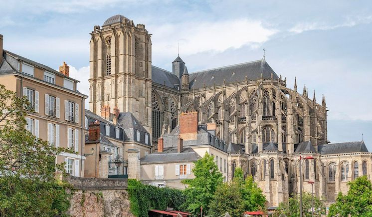
Tours
Tours is a university town between the French rivers Cher and Loire. Once a Gallo-Roman settlement, Tours is now a traditional base for exploring the castles of the Loire Valley. A major landmark is the Cathedral of Saint-Gatien, whose striking Gothic façade is flanked by towers with a 12th-century base and Renaissance spires.
Story:
In pre-Roman times, the Celtic Turones settled on a hill on the right bank of the Loire, which the Romans later called Caesarodunum (Caesar's Hill).
In 732, Charles Martel defeated the Moors in the Battle of Tours and Poitiers, killing the Moors' leader, Abd ar-Rahman. This victory by Charles Martel prevented the Islamic sphere of influence from spreading further. Under Charlemagne, Tours was the centre of the Carolingian Renaissance with important book illumination and the school of Alcuin, an abbot of Saint-Martin de Tours, who gave the first lectures on theology and philosophy here at the end of the 8th century.
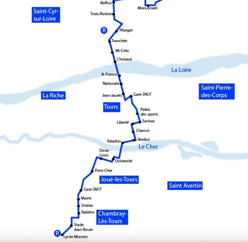
tram network of Tours
Galerie Nationale, Tours, Indre-et-Loire, Zentrum-Loiretal, Frankreich
47° 23' 29.3" N 0° 41' 20.3" E
47.3914592 0.6889749
• Head toward Rue Victor Laloux on Rue des Minimes. Go for 146 m.
• Turn right onto Rue Honoré de Balzac. Go for 99 m.
• Turn right onto Boulevard Heurteloup. Go for 238 m.
• Continue on Boulevard Béranger. Go for 924 m.
• Turn left onto Rue Giraudeau. Go for 1.4 km.
• Turn left onto Rue Fromentel. Go for 110 m.
• Turn right onto Rue Auguste Chevallier. Go for 276 m.
• Take the 2nd exit from Rond-Point Saint-Sauveur roundabout onto Pont Saint-Sauveur (D86) toward Joué lès Tours. Go for 389 m.
• Take the 1st exit from Rond-Point Jacques Monod roundabout onto Route de Savonnières (D7). Go for 1.7 km.
• Pass 5 roundabouts and continue on Route de Tours (D7). Go for 8.5 km.
• Take the 1st exit from roundabout onto Rue Principale (D7). Go for 449 m.
• Take the 2nd exit from roundabout onto Route des Grottes Pétrifiantes (D7). Go for 2.3 km.
• Turn left onto Lieu-dit Le Château. Go for 70 m.
• Arrive at Lieu-dit Le Château. Your destination is on the left.
☍
16,7 km
( 21 min.)
Day
Day
Château de Villandry
The castle of Villandry was built around 1536 as the last and most beautiful of the great Loire castles.
The gardens are a jewel - they are considered the most beautiful of all the Loire castles.
Entrance fee:
Garden area only 7.50€
Garden and Castle 12€
Indre-et-Loire, Zentrum, Frankreich
47° 20' 26" N 0° 30' 52.6" E
47.3405610 0.5146089
• Head toward Rue Principale on Lieu-dit Le Château. Go for 70 m.
• Turn left onto Rue Principale (D7). Go for 605 m.
• Enter the roundabout. Go for 12 m.
• Arrive at your destination on the right.
☍
0,7 km
( 1 min.)
Aire du Camping-cars Villandry
Rue Principale, 37510, Villandry, Frankreich
47° 20' 21.4" N 0° 30' 26.6" E
47.3392910 0.5074000
• Follow the roundabout. Go for 10 m.
• Take the 2nd exit from roundabout onto Rue Principale (D7). Go for 3.1 km.
• Turn left onto Rue du Val de Loire (D39). Go for 1.5 km.
• Continue on Voie d'Azay (D39). Go for 253 m.
• Take the 1st exit from roundabout onto Voie d'Azay (D39). Go for 1.8 km.
• Continue on Route de Villandry (D39). Go for 3.2 km.
• Take the 1st exit from roundabout onto Route de Cosne à la Pointe-Saint-Gildas (D751). Go for 18.1 km.
• Take the 2nd exit from roundabout onto Route de Tours (D751). Go for 940 m.
• Take the 3rd exit from roundabout onto Avenue François Mitterrand. Go for 1.1 km.
• Pass 2 roundabouts and continue on Avenue François Mitterrand. Go for 1.7 km.
• Take the 2nd exit from roundabout onto Quai Charles VII (D749). Go for 366 m.
• Take the 2nd exit from roundabout onto Quai Jeanne d'Arc (D8). Go for 141 m.
• Take the 2nd exit from roundabout onto Rue Neuve de l'Hôtel de Ville. Go for 71 m.
• Continue on Place du Général de Gaulle. Go for 67 m.
• Arrive at Place du Général de Gaulle. Your destination is on the right.
☍
32,4 km
( 27 min.)
Chinon
Indre-et-Loire, Zentrum, Frankreich
47° 10' 0.2" N 0° 14' 24.8" E
47.1667182 0.2402095
• Head toward Rue Voltaire on Place du Général de Gaulle. Go for 37 m.
• Turn sharp left onto Place du Général de Gaulle. Go for 103 m.
• Continue on Rue Neuve de l'Hôtel de Ville. Go for 39 m.
• Take the 1st exit from roundabout onto Quai Jeanne d'Arc (D8). Go for 124 m.
• Take the 2nd exit from roundabout onto Quai Charles VII (D749). Go for 356 m.
• Take the 1st exit from roundabout onto Avenue François Mitterrand. Go for 494 m.
• Arrive at Avenue François Mitterrand. Your destination is on the right.
☍
1,2 km
( 2 min.)
Forteresse Royale de Chinon
Avenue François Mitterrand, Chinon, Indre-et-Loire, Zentrum, Frankreich
47° 10' 5.3" N 0° 14' 9.6" E
47.1681505 0.2359923
• Head toward Rue du Pavé Neuf on Avenue François Mitterrand. Go for 477 m.
• Take the 2nd exit from roundabout onto Quai Charles VII (D749). Go for 366 m.
• Take the 1st exit from roundabout onto D749. Go for 246 m.
• Turn right onto Quai Danton. Go for 298 m.
• Turn left onto Rue de la Digue Saint-Jacques. Go for 26 m.
• Arrive at Rue de la Digue Saint-Jacques. Your destination is on the left.
☍
1,4 km
( 2 min.)
Camping Intercommunal De L'ile Auger
Quai Danton, 37500, Chinon, Frankreich
47° 9' 48" N 0° 14' 5" E
47.1633300 0.2347200
• Head toward Rue Porte du Bourg on Rue de la Digue Saint-Jacques. Go for 83 m.
• Turn slightly left onto Rue des Ursulines. Go for 342 m.
• Turn right onto Rue du Faubourg Saint-Jacques (D749). Go for 1.2 km.
• Take the 1st exit from roundabout onto Rue de Saumur (D751 E) toward A85/Saumur/Chinon/La Roche-Clermault/Candes St Martin/Bourgueil/Loudun/La Devinière. Go for 2.8 km.
• Take the 2nd exit from roundabout onto D751 toward Saumur. Go for 10.5 km.
• Turn right onto D7 toward D751/Candes St Martin/Écomusée du Véron/Bourgueil. Go for 640 m.
• Take the 2nd exit from roundabout onto Lieu-dit Les Basses Vignes (D7). Go for 361 m.
• Turn left onto Rue du Bac. Go for 94 m.
• Continue on Route de Compostelle. Go for 889 m.
• Take the 1st exit from roundabout onto Route de Compostelle. Go for 87 m.
• Continue on Quai Alexandre Dumas (D751 A). Go for 796 m.
• Continue on Avenue de la Loire (D947). Go for 938 m.
• Take the 1st exit from roundabout onto D952 A toward Villebernier/Varennes S/Loire/Chouzé S/Loire. Go for 882 m.
• Take the 3rd exit from roundabout onto Rue Nationale des Redouets (D952) toward Saumur. Go for 10.3 km.
• Take the 3rd exit from Rond-Point Noëlla Rouget roundabout onto Pont des Cadets de Saumur (D947) toward Centre Ville/Les Ponts. Go for 261 m.
• Take the 4th exit from roundabout onto Quai du Roi René. Go for 332 m.
• Continue on Rue de Verden. Go for 501 m.
• Turn slightly left onto Rue de Verden. Go for 78 m.
• Arrive at Rue de Verden. Your destination is on the right.
☍
31,1 km
( 30 min.)
Day
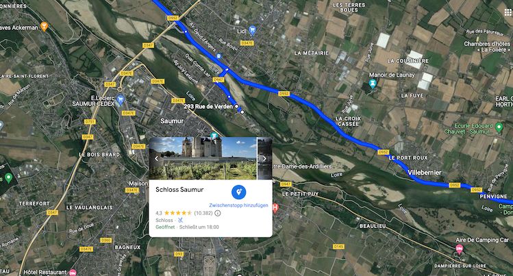
Aire Camping-Car Rue de Verden, 49400 Saumur
Lt. Promobil
Motorhome parking Aire Camping-Car Park Saumur in Saumur 12.00 EUR/night
3 reviews
Paid parking space for 35 mobile homes outside Saumur. The parking space is close to the river and in an area designed and designated for mobile homes. Mostly flat, partially shady area. Paved and gravelled surface with grass.
Center can be reached on foot. On site: WiFi.
Nearby: Old town, palace/castle. Price per night including two adults: 10.80 - 12 euros depending on the season. Payment: parking ticket machine.
Electricity, water, grey water disposal, chemical toilet disposal, dogs included in the overnight price.
Maximum stay: 7 nights. Attention: Access only with “Pass'Étapes” membership card.
Can be ordered for a one-time fee of 5 EUR on the Camping-Car Park website mentioned above.
Boulevard de Verden, Saumur, Maine-et-Loire, Pays de la Loire, Frankreich
47° 15' 38.1" N 0° 3' 55.8" W
47.2605950 -0.0655026
• Head west on Rue de Verden. Go for 173 m.
• Turn slightly left onto Rue des Aulnes. Go for 252 m.
• Turn right onto Rue des Capucins-d'Offard. Go for 45 m.
• Turn left onto Rue des Capucins-d'Offard. Go for 67 m.
• Continue on Rue Paul Bert. Go for 238 m.
• Take the 2nd exit from roundabout onto Avenue du Général de Gaulle (D947). Go for 408 m.
• Take the 1st exit from roundabout onto Quai Carnot. Go for 261 m.
• Turn left onto Place Kléber. Go for 112 m.
• Continue on Place Chanzy. Go for 14 m.
• Continue on Rue des Carabiniers de Monsieur. Go for 136 m.
• Continue on Rue Chanzy. Go for 109 m.
• Continue on Rue Gambetta. Go for 283 m.
• Turn right onto Rue d'Alsace. Go for 220 m.
• Arrive at Rue d'Alsace. Your destination is on the right.
☍
2,3 km
( 5 min.)
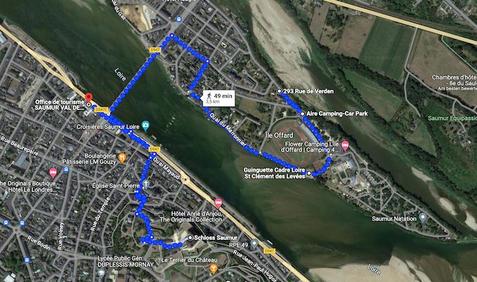
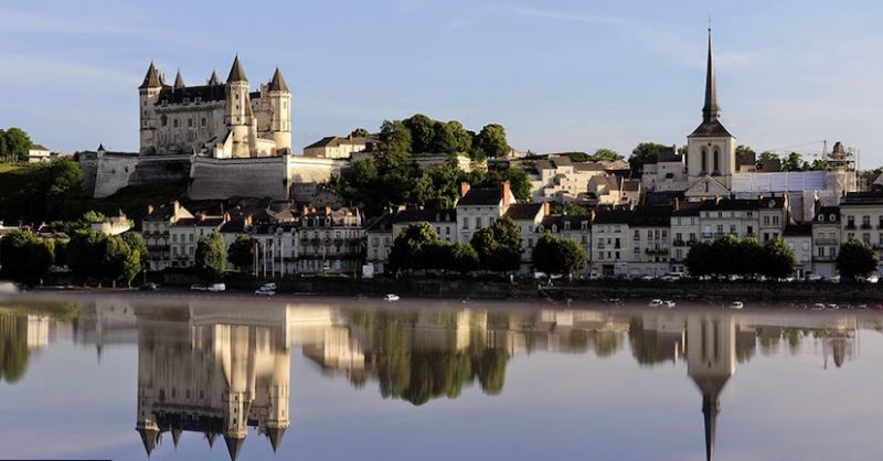
Saumur
Rue d'Alsace, Saumur, Maine-et-Loire, Pays de la Loire, Frankreich
47° 15' 33.6" N 0° 5' 9" W
47.2593353 -0.0858425
• Head northwest on Rue d'Alsace. Go for 239 m.
• Take the 1st exit from roundabout onto Boulevard Maréchal de Lattre de Tassigny. Go for 321 m.
• Take the 2nd exit from roundabout onto Boulevard du Général Weygand. Go for 216 m.
• Take the 2nd exit from Rond-Point du Général Weygand roundabout onto D347 toward Angers/Le Mans/Tours/Z.I. St Lambert. Go for 4.3 km.
• Take the 2nd exit from Rond-Point du Fleuret roundabout onto D347 toward Tours/Le Mans/Angers/Longué/Vivy. Go for 2.3 km.
• Take the 2nd exit from Rond-Point de la Ronde roundabout onto D767 toward Angers/Tours/Le Mans/Allonnes/Vernantes. Go for 577 m.
• Take the 3rd exit from roundabout toward Le Mans/Angers/Tours. Go for 161 m.
• Take ramp onto A85 toward Nantes/Le Mans/Angers. Go for 36.9 km.
• Continue toward Nantes/Angers. Go for 212 m.
• Take the exit onto A11 (L'Océane). Go for 70.7 km.
• Take exit 20 toward Ancenis. Go for 1.1 km.
• Take the 1st exit from Rond-Point de Nantes roundabout onto D923 toward Nantes/Ancenis. Go for 344 m.
• Pass 2 roundabouts and continue on D923. Go for 1.1 km.
• Take the 2nd exit from roundabout onto Rue de l'Aubinière toward Ancenis. Go for 538 m.
• Take the 2nd exit from Rond-Point de la Fouquetière roundabout onto Rue de l'Aubinière. Go for 446 m.
• Take the 3rd exit from Rond-Point de l'Hermitage roundabout onto Rue de Chateaubriand. Go for 634 m.
• Take the 2nd exit from Rond-Point des Jaunets roundabout onto Rue de Chateaubriand. Go for 506 m.
• Take the 2nd exit from roundabout onto Avenue Francis Robert (D14). Go for 146 m.
• Take the 1st exit from roundabout onto Avenue Francis Robert (D14). Go for 332 m.
• Continue on Rue Georges Clemenceau (D14). Go for 103 m.
• Turn right onto Boulevard Joseph Vincent. Go for 181 m.
• Pass 4 roundabouts and continue on Boulevard Joseph Vincent. Go for 694 m.
• Take the 3rd exit from Rond-Point de la Davrays roundabout onto Avenue de la Davrays (D23). Go for 92 m.
• Turn right onto Rue Antoinette de Bruc. Go for 12 m.
• Continue on Place de Rohan. Go for 15 m.
• Take the 2nd exit from roundabout onto Impasse de l'Île Mouchet. Go for 52 m.
• Turn slightly right onto Impasse de l'Île Mouchet. Go for 98 m.
• Arrive at Impasse de l'Île Mouchet. Your destination is on the right.
☍
122,3 km
(1 hrs. 11 min.)
Day
Camping de l’île Mouchet
Impasse de l'ile mouchet, 44150, Ancenis, Frankreich
47° 21' 44.6" N 1° 11' 14.3" W
47.3624000 -1.1873000
• Head toward Boulevard de Kirkham on Impasse de l'Île Mouchet. Go for 121 m.
• Take the 1st exit from roundabout onto Place de Rohan. Go for 29 m.
• Continue on Rue Antoinette de Bruc. Go for 12 m.
• Turn right onto Boulevard de Kirkham (D23). Go for 51 m.
• Take the 2nd exit from Rond-Point de la Davrays roundabout onto Boulevard Joseph Vincent. Go for 297 m.
• Pass 4 roundabouts and continue on Boulevard Joseph Vincent. Go for 617 m.
• Turn left onto Rue Georges Clemenceau (D14). Go for 103 m.
• Continue on Avenue Francis Robert (D14). Go for 321 m.
• Take the 2nd exit from roundabout onto Avenue Francis Robert (D14). Go for 132 m.
• Take the 2nd exit from roundabout onto Rue de Chateaubriand. Go for 488 m.
• Take the 2nd exit from Rond-Point des Jaunets roundabout onto Rue de Chateaubriand. Go for 636 m.
• Take the 2nd exit from Rond-Point de l'Hermitage roundabout onto Rue de l'Aubinière. Go for 441 m.
• Take the 2nd exit from Rond-Point de la Fouquetière roundabout onto Rue de l'Aubinière. Go for 476 m.
• Take the 3rd exit from roundabout onto D923 toward A11/Nantes/Laval/Nort S/Erdre. Go for 185 m.
• Pass 2 roundabouts and continue on D923. Go for 1.3 km.
• Take the 3rd exit from Rond-Point de Nantes roundabout onto A11 (L'Océane) toward Nantes. Go for 33.1 km.
• Take exit 38 toward Bordeaux/Poitiers/Nantes-Nord onto N844 (Périphérique Est). Go for 1.3 km.
• Take ramp toward Nantes-Centre/Nantes-Nord/Porte de la Chapelle. Go for 262 m.
• Take the 2nd exit from roundabout onto Boulevard Martin Luther King toward Nantes-Centre/Petit Port/P+R Recteur Schmitt. Go for 789 m.
• Continue on Rue Henri Picherit. Go for 232 m.
• Take the 2nd exit from roundabout onto Boulevard Guy Mollet. Go for 361 m.
• Pass 2 roundabouts and continue on Boulevard Guy Mollet. Go for 681 m.
• Take the 2nd exit from Place du 8 Mai 1945 roundabout onto Boulevard du Petit Port. Go for 164 m.
• Turn right onto Rue de la Perverie. Go for 14 m.
• Turn right onto Rue de la Perverie. Go for 158 m.
• Arrive at Rue de la Perverie. Your destination is on the left.
☍
42,2 km
( 31 min.)
Day
Day
Camping-car Park, Boulevard du Petit-Port
Boulevard du Petit-Port 21, Nantes, Loire-Atlantique, Pays de la Loire, Frankreich
47° 14' 34.1" N 1° 33' 29.8" W
47.2428047 -1.5582836
• Head east on Rue de la Perverie. Go for 72 m.
• Turn left. Go for 26 m.
• Arrive at your destination on the left.
☍
0,1 km
( )
Camping-car Park Nantes
Boulevard du petit Port 21, 44300, Nantes, Frankreich
47° 14' 35" N 1° 33' 27" W
47.2430556 -1.5575000
• Head toward Rue de la Perverie. Go for 26 m.
• Turn left onto Rue de la Perverie. Go for 86 m.
• Turn left onto Rue de la Perverie. Go for 14 m.
• Turn right onto Boulevard du Petit Port. Go for 133 m.
• Take the 1st exit from roundabout onto Boulevard Gabriel Lauriol. Go for 1.0 km.
• Take the 1st exit from roundabout onto Boulevard des Frères de Goncourt toward St Herblain/Nantes-Ouest. Go for 219 m.
• Take the 2nd exit from Rond-Point de Rennes roundabout onto Rue Paul Bellamy toward Centre Ville. Go for 1.6 km.
• Take the 1st exit from roundabout toward Sud-Centre Ville/Est-Centre Ville. Go for 10 m.
• Take the 2nd exit from roundabout onto Rue Paul Bellamy toward Sud-Centre Ville/Est-Centre Ville. Go for 85 m.
• Continue on Place du Pont Morand. Go for 45 m.
• Take the 2nd exit from Place du Port Communeau roundabout onto Place du Port Communeau toward Sud-Centre Ville/C.H.U. Hôtel Dieu. Go for 76 m.
• Continue on Rue de Strasbourg. Go for 652 m.
• Take the 2nd exit from Square Elsa Mercoeur roundabout toward Aéroport Nantes-Atlantique/Nantes-Sud/Île de Nantes/Cité des Congrès. Go for 260 m.
• Take the 2nd exit from roundabout toward Nantes-Sud/Île de Nantes. Go for 152 m.
• Continue on Avenue Carnot. Go for 314 m.
• Continue on Avenue Jean-Claude Bonduelle. Go for 166 m.
• Take the 3rd exit from roundabout onto Rue de Fleurus toward Centre Ville/Rezé/Madeleine/C.H.U. Hôtel Dieu/Paris/Poitiers/Rennes/Nantes-Est/Malakoff. Go for 130 m.
• Take the 2nd exit from roundabout onto Rue de Fleurus toward Paris/Poitiers/Rennes/Nantes-Est/Malakoff. Go for 51 m.
• Continue on Pont de Tbilissi. Go for 228 m.
• Take the 6th exit from roundabout onto Quai Malakoff. Go for 273 m.
• Arrive at Quai Malakoff. Your destination is on the left.
☍
5,5 km
( 11 min.)
Nantes
Dépose-minute, Nantes, Loire-Atlantique, Pays de la Loire, Frankreich
47° 12' 52.8" N 1° 32' 29.7" W
47.2146590 -1.5415824
• Head toward Rue du Pré Gauchet on Quai Malakoff. Go for 165 m.
• Take the 1st exit from roundabout onto Pont de Tbilissi toward Vannes/Saint Herblain/Rezé/Centre Ville/C.H.U. Hôtel Dieu. Go for 248 m.
• Continue on Rue de Fleurus. Go for 22 m.
• Take the 2nd exit from roundabout onto Rue de Fleurus toward Vannes/St Nazaire/St Herblain/C.H.U. Hôtel Dieu. Go for 132 m.
• Take the 1st exit from roundabout onto Quai Magellan toward Bordeaux/Vannes/St Nazaire/St Herblain/Nantes-Ouest/Île de Nantes-Beaulieu. Go for 49 m.
• Continue on Quai André Morice. Go for 99 m.
• Take the 3rd exit from roundabout onto Quai André Morice toward Vannes/St Nazaire/St Herblain/Nantes-Ouest. Go for 1.2 km.
• Take the 3rd exit from roundabout onto Rue Gaston Michel toward Vannes/St Nazaire/St Herblain/Nantes-Ouest. Go for 221 m.
• Take the 2nd exit from roundabout onto Rue Gaston Michel toward Ouest-Centre Ville/Vannes/St Nazaire/St Herblain. Go for 152 m.
• Continue on Quai de la Fosse. Go for 761 m.
• Take the 2nd exit from Place de Jacksonville roundabout onto Place de Jacksonville toward Porte de St Herblain. Go for 258 m.
• Keep left onto Boulevard Salvador Allende. Go for 288 m.
• Continue on Boulevard Benoît Frachon toward Vannes/St Nazaire/St Herblain. Go for 251 m.
• Continue on Boulevard Président René Coty. Go for 387 m.
• Take the 2nd exit from roundabout onto Boulevard Léon Jouhaux. Go for 715 m.
• Take the 1st exit from Place de la Croix Bonneau roundabout onto Place de la Croix Bonneau. Go for 54 m.
• Continue on Rue du Corps de Garde. Go for 356 m.
• Pass 2 roundabouts and continue on Rue du Corps de Garde. Go for 644 m.
• Take the 2nd exit from roundabout onto Rue Maurice Garin. Go for 184 m.
• Take the 1st exit from roundabout onto Boulevard du Tertre. Go for 303 m.
• Take the 5th exit from Rond-Point Abel Durand roundabout onto Boulevard Charles Gautier (M201) toward Crémetterie/Preux/C.H.U. Nord-Laënnec/Hôpital Santé Atlantique. Go for 489 m.
• Pass 5 roundabouts and continue on Boulevard Charles Gautier (M201). Go for 1.1 km.
• Take the 3rd exit from roundabout onto N444 toward Vannes/St Nazaire/St Herblain-Centre. Go for 5.8 km.
• Take ramp onto N165. Go for 23.2 km.
• Take ramp onto N171 toward La Baule/St Nazaire/Savenay-Centre. Go for 19.6 km.
• Take ramp toward D50/Montoir de Bgne/Ports de Montoir et St Nazaire/Parc de la Brière. Go for 299 m.
• Take the 4th exit from roundabout onto D971. Go for 618 m.
• Take the 2nd exit from roundabout onto D971. Go for 634 m.
• Take the 1st exit from roundabout onto D971. Go for 1.3 km.
• Turn left onto Rue Anatole France (D971 A). Go for 159 m.
• Take the 1st exit from roundabout onto Boulevard des Apprentis (D971 A). Go for 918 m.
• Take the 2nd exit from roundabout. Go for 502 m.
• Pass 2 roundabouts and continue on Boulevard des Apprentis. Go for 486 m.
• Turn left. Go for 55 m.
• Turn left. Go for 316 m.
• Arrive at your destination on the left.
☍
61,8 km
( 48 min.)
Day
Day
Sémaphore du Brivet
Rue de l'Aviation, Saint-Nazaire, Loire-Atlantique, Pays de la Loire, Frankreich
47° 17' 39" N 2° 10' 52" W
47.2941622 -2.1811229
• Head south. Go for 350 m.
• Turn right. Go for 33 m.
• Turn left toward Boulevard des Apprentis. Go for 55 m.
• Turn right onto Boulevard des Apprentis. Go for 164 m.
• Take the 3rd exit from roundabout onto Rue Émile Ollivaud. Go for 70 m.
• Turn right onto Rue de la Loire. Go for 111 m.
• Take the 2nd exit from Giratoire Nicolas Faucier roundabout onto Rue de Trignac. Go for 610 m.
• Take ramp onto Route Bleue (D213). Go for 5.8 km.
• Keep left onto Route Bleue (D213) toward La Baule/Pornichet/Guérande/P.A. Brais Pedras. Go for 11.3 km.
• Take ramp toward D192/La Baule-Centre/La Baule-Ouest. Go for 181 m.
• Take the 4th exit from roundabout. Go for 253 m.
• Take the 1st exit from roundabout onto D192. Go for 1.7 km.
• Take the 3rd exit from Rond-Point des Salines roundabout onto Route de la Baule (D92). Go for 472 m.
• Take the 2nd exit from Place des Salines roundabout onto Boulevard du Docteur Chevrel (D92). Go for 617 m.
• Take the 1st exit from Place de la Victoire roundabout onto Avenue du Maréchal de Lattre de Tassigny. Go for 361 m.
• Turn left onto Avenue des Pétrels. Go for 99 m.
• Turn left onto Avenue des Ibis. Go for 83 m.
• Turn right onto Avenue du Marché. Go for 76 m.
• Turn left. Go for 34 m.
• Arrive at your destination on the right.
☍
22,4 km
( 19 min.)
La Baule-Escoublac
Loire-Atlantique, Pays de la Loire, Frankreich
47° 17' 3.7" N 2° 23' 42.6" W
47.2843726 -2.3951595
• Head toward Impasse des Alcyons. Go for 26 m.
• Turn left onto Impasse des Alcyons. Go for 75 m.
• Turn left onto Avenue Olivier Guichard. Go for 203 m.
• Keep left onto Avenue du Maréchal de Lattre de Tassigny. Go for 1.4 km.
• Take the 2nd exit from roundabout onto Avenue du Maréchal de Lattre de Tassigny. Go for 941 m.
• Take the 1st exit from Avenue du Maréchal de Lattre de Tassigny roundabout onto Boulevard Guy de Champsavin. Go for 284 m.
• Turn right. Go for 48 m.
• Arrive at your destination on the right.
☍
3,0 km
( 5 min.)
Day
Camping car park, La Baule-Escoublac
Camping car parkAire camping car Park, 44500 La Baule-Escoublac
Avenue des Coquelicots, La Baule-Escoublac, Loire-Atlantique, Pays de la Loire, Frankreich
47° 16' 55" N 2° 25' 30.7" W
47.2819319 -2.4251821
• Head south. Go for 48 m.
• Turn right onto Boulevard Guy de Champsavin. Go for 95 m.
• Continue on Boulevard de la Libération. Go for 201 m.
• Take the 3rd exit from roundabout onto Boulevard de la Libération. Go for 328 m.
• Take the 2nd exit from Place de la Gare roundabout onto Place de la Gare (D45). Go for 1.1 km.
• Take the 1st exit from roundabout onto D774. Go for 698 m.
• Take the 3rd exit from Rond-Point de la Dépêche roundabout onto Lieu-dit La Dépêche (D92). Go for 353 m.
• Continue on D92. Go for 2.9 km.
• Turn right. Go for 43 m.
• Turn left. Go for 40 m.
• Arrive at your destination on the left.
☍
5,9 km
( 7 min.)
Day
Terre de Sel
Loire-Atlantique, Pays de la Loire, Frankreich
47° 18' 57.7" N 2° 27' 8.7" W
47.3160408 -2.4524266
• Head south. Go for 40 m.
• Turn right toward D92. Go for 43 m.
• Turn right onto D92. Go for 91 m.
• Continue on Clos de la Motte (D92). Go for 147 m.
• Turn right onto Lieu-dit Le Clos de La Motte. Go for 147 m.
• Take the 1st exit from roundabout onto Rue de Pradel. Go for 353 m.
• Turn left toward Chemin du Parc de la Tonnelle. Go for 811 m.
• Keep right onto Chemin du Parc de la Tonnelle. Go for 460 m.
• Turn slightly left onto Chemin de la Tonnelle. Go for 67 m.
• Arrive at Chemin de la Tonnelle. Your destination is on the right.
☍
2,2 km
( 5 min.)
Guérande
Chemin de la Tonnelle, Guérande, Loire-Atlantique, Pays de la Loire, Frankreich
47° 19' 28.4" N 2° 26' 4.9" W
47.3245515 -2.4347042
• Head toward Impasse de la Ville aux Clercs on Chemin de la Tonnelle. Go for 59 m.
• Take the 2nd exit from roundabout onto Chemin de la Tonnelle. Go for 280 m.
• Turn right onto Boulevard du Midi. Go for 201 m.
• Continue on Boulevard de Dinkesbuhl. Go for 237 m.
• Continue on Place du Marché au Bois (D51). Go for 68 m.
• Turn right onto Chemin du Guesny. Go for 291 m.
• Take the 1st exit from roundabout onto Chemin du Guesny. Go for 217 m.
• Turn right onto Faubourg Saint-Michel (D99). Go for 296 m.
• Turn left onto Faubourg Saint-Michel. Go for 33 m.
• Arrive at Faubourg Saint-Michel. Your destination is on the left.
☍
1,7 km
( 4 min.)
Guérande
Maison de la famille, Faubourg Saint-Michel, Le Guesny, Saint-Michel, Guérande, Saint-Nazaire, Loire-Atlantique, Pays de la Loire, Metropolitanes Frankreich, 44350, Frankreich
47° 19' 34.9" N 2° 25' 32.9" W
47.3263704 -2.4257978
• Head southeast on Faubourg Saint-Michel. Go for 33 m.
• Turn left onto Faubourg Saint-Michel (D99). Go for 162 m.
• Continue on Place du Marché au Bois (D51). Go for 68 m.
• Continue on Rue du Pavé de Beaulieu (D51). Go for 102 m.
• Take the 1st exit from roundabout onto Avenue de la Brière (D51). Go for 189 m.
• Take the 2nd exit from Place de l'Europe roundabout onto Avenue de la Brière (D51). Go for 384 m.
• Continue on D51. Go for 161 m.
• Take the 3rd exit from roundabout onto Route Bleue (D99 E) toward D774/Vannes/Herbignac/La Turballe/Redon/Pontchâteau. Go for 1.1 km.
• Take the 5th exit from roundabout onto Route Bleue (D99 E) toward D774/La Baule/St Nazaire/Le Pouliguen/Batz S/Mer/Le Croisic. Go for 1.1 km.
• Arrive at Route Bleue (D99 E). Your destination is on the right.
☍
3,4 km
( 4 min.)
Aire CAMPING-CAR PARK de Guérande
Route de Guérande, Guérande, Loire-Atlantique, Pays de la Loire, Frankreich
47° 20' 2.1" N 2° 25' 15.1" W
47.3339115 -2.4208598
• Head southeast on Route Bleue (D99 E). Go for 88 m.
• Take the 1st exit from roundabout onto D51 toward Guérande/Centre Ville. Go for 179 m.
• Continue on Avenue de la Brière (D51). Go for 353 m.
• Take the 1st exit from Place de l'Europe roundabout onto Avenue Anne de Bretagne. Go for 378 m.
• Take the 3rd exit from Place du 11 Novembre 1918 roundabout onto Boulevard du Général de Gaulle. Go for 1.2 km.
• Continue on Route de la Turballe (D99). Go for 123 m.
• Take the 2nd exit from roundabout onto Route de la Turballe (D99). Go for 1.7 km.
• Turn right onto Chemin des Perrières. Go for 82 m.
• Turn slightly left onto Chemin des Perrières. Go for 89 m.
• Turn slightly right onto Place des Perrières. Go for 35 m.
• Turn left onto Place des Perrières. Go for 33 m.
• Continue on Chemin du Barinez. Go for 78 m.
• Continue on Rue des Rigadeaux. Go for 133 m.
• Turn right onto Route de la Turballe (D99). Go for 571 m.
• Continue on D99. Go for 854 m.
• Continue on Rue du Grand Chemin (D99). Go for 65 m.
• Take the 2nd exit from roundabout onto Rue Sully (D99) toward Piriac S/Mer/Centre Ville/Z.A. la Marjolaine/Complexe Sportif. Go for 925 m.
• Continue on Boulevard de l'Europe (D99). Go for 225 m.
• Take the 2nd exit from Giratoire de l'Europe roundabout onto Boulevard de l'Europe (D99). Go for 378 m.
• Take the 3rd exit from roundabout onto Rue de la Frégate (D33). Go for 342 m.
• Take the 2nd exit from Rue Colbert roundabout onto Rue Colbert (D33). Go for 458 m.
• Take the 3rd exit from roundabout onto Boulevard Bellanger (D92). Go for 49 m.
• Arrive at Boulevard Bellanger (D92). Your destination is on the right.
☍
8,3 km
( 12 min.)
Day
La Turballe
D 92, La Turballe, Loire-Atlantique, Pays de la Loire, Frankreich
47° 20' 36.3" N 2° 30' 24.5" W
47.3434065 -2.5068039
• Head northwest on Boulevard Bellanger (D92). Go for 18 m.
• Take the 2nd exit from roundabout onto Boulevard Bellanger. Go for 203 m.
• Take the 2nd exit from roundabout onto Quai Saint-Jacques. Go for 299 m.
• Continue on Boulevard du Commandant Raymond Fam. Go for 153 m.
• Take the 1st exit from Place du Général de Gaulle roundabout onto Place de l'Ancienne Gare. Go for 45 m.
• Continue on Rue du Maréchal Juin. Go for 333 m.
• Take the 2nd exit from roundabout onto Rue du Maréchal Juin. Go for 212 m.
• Continue on Boulevard de Belmont. Go for 235 m.
• Turn left onto Boulevard de Belmont (D99). Go for 1.3 km.
• Continue on Avenue Louis Clément (D99). Go for 588 m.
• Turn right onto Route de Kervin (D299). Go for 771 m.
• Turn left onto Route de Guérande (D333). Go for 763 m.
• Take the 2nd exit from Giratoire de Polobeau roundabout onto Route de Guérande (D333) toward Piriac-sur-Mer. Go for 323 m.
• Turn right onto Rue du Clos Brûlé (D452). Go for 206 m.
• Take the 2nd exit from roundabout onto Avenue du Général de Gaulle (D452). Go for 1.1 km.
• Continue on Route de Port au Loup (D452). Go for 321 m.
• Turn left onto Avenue du Général de Gaulle (D452). Go for 1.7 km.
• Turn right. Go for 15 m.
• Turn right. Go for 38 m.
• Arrive at your destination on the left.
☍
8,6 km
( 12 min.)
Aire de Camping-Car Piriac Brambell
Vélocéan, Piriac-sur-Mer, Loire-Atlantique, Pays de la Loire, Frankreich
47° 23' 47.3" N 2° 30' 46.5" W
47.3964646 -2.5129187
• Head northeast. Go for 38 m.
• Turn left toward Avenue du Général de Gaulle/D452. Go for 15 m.
• Turn right onto Avenue du Général de Gaulle (D452). Go for 1.3 km.
• Continue on Route de l'Île Dumet (D452). Go for 634 m.
• Take the 1st exit from roundabout onto Route du Pays Blanc (D452). Go for 575 m.
• Take the 2nd exit from roundabout onto Route de Mélido (D52) toward Mesquer. Go for 578 m.
• Continue on Route de Kerlagadec (D52). Go for 983 m.
• Turn left onto Route de la Noë (D52 B). Go for 546 m.
• Continue on Rue Saint-Gobrien (D52 B). Go for 123 m.
• Continue on Rue du Soleil. Go for 86 m.
• Turn left onto Rue d'Aha (D252). Go for 76 m.
• Turn left onto Avenue de Bretagne (D52 B). Go for 5 m.
• Turn right onto Rue de Kercabellec. Go for 651 m.
• Continue on Rue des Cap-Horniers (D352). Go for 576 m.
• Turn right onto Rue du Port. Go for 255 m.
• Arrive at Rue du Port. Your destination is on the right.
☍
6,4 km
( 9 min.)
Port de Kercabellec
Loire-Atlantique, Pays de la Loire, Frankreich
47° 24' 39" N 2° 27' 50.7" W
47.4108389 -2.4640784
• Head southwest on Rue du Port. Go for 831 m.
• Continue on Rue de la Gambade (D352). Go for 584 m.
• Turn left onto Rue du Soleil. Go for 86 m.
• Turn right onto Rue de la Grand Vigne (D252). Go for 719 m.
• Take the 3rd exit from roundabout onto Route du Jardin du Comte (D52). Go for 2.3 km.
• Take the 2nd exit from Rond-Point du Mes roundabout onto Route de Mesquer (D52). Go for 245 m.
• Continue on Rue de l'Océan (D33). Go for 576 m.
• Turn left onto Rue de la Duchesse Anne (D33). Go for 169 m.
• Take the 2nd exit from Rond-Point Pont Belles Filles roundabout onto Route d'Assérac (D33). Go for 681 m.
• Continue on D33. Go for 996 m.
• Continue on Lieu-dit Le Point du Jour (D33). Go for 251 m.
• Continue on D33. Go for 395 m.
• Continue on Rue du Mès (D33). Go for 1.4 km.
• Continue on D33. Go for 84 m.
• Continue on Lieu-dit le moulin de Pont d'Arm (D33). Go for 123 m.
• Continue on Rue du Pont de Bois (D33). Go for 840 m.
• Continue on Rue du Pont Bérin (D33). Go for 262 m.
• Turn left onto Place Olivier Guichard. Go for 74 m.
• Turn left onto Rue du Centre (D83). Go for 26 m.
• Turn right onto Rue du Pont aux Pages (D82). Go for 541 m.
• Continue on D82. Go for 1.7 km.
• Continue on Lieu-dit La Briandais (D82). Go for 184 m.
• Continue on D82. Go for 102 m.
• Continue on Route de Pont-Mahé (D82). Go for 3.2 km.
• Continue on Route d'Assérac (D201). Go for 1.9 km.
• Turn left onto Route de l'Armor. Go for 41 m.
• Continue on Route de l'Armor (VC7). Go for 1.0 km.
• Turn right onto Allée de Kerlay. Go for 137 m.
• Turn left onto Route de Kervraud. Go for 219 m.
• Turn right onto Chemin du Ruello. Go for 303 m.
• Arrive at Chemin du Ruello. Your destination is on the left.
☍
19,9 km
( 24 min.)
Day
Aire CAMPING-CAR PARK de Pénestin, Le Béchet
Route des Trois Iles, Pénestin, Morbihan, Bretagne, Frankreich
47° 26' 51.8" N 2° 29' 16.7" W
47.4477101 -2.4879773
• Head toward Allée de l'Aloès on Chemin du Ruello. Go for 303 m.
• Turn left onto Route de Kervraud. Go for 219 m.
• Turn right onto Allée de Kerlay. Go for 137 m.
• Turn left onto Route de l'Armor. Go for 408 m.
• Continue on Route de l'Armor. Go for 662 m.
• Turn left onto Route d'Assérac (D201). Go for 1.9 km.
• Take the 1st exit from roundabout onto Boulevard de l'Océan (D201). Go for 222 m.
• Pass 2 roundabouts and continue on Boulevard de l'Océan (D201). Go for 825 m.
• Take the 1st exit from roundabout onto D34. Go for 1.2 km.
• Continue on Lieu-dit Le Cénic (D34). Go for 100 m.
• Continue on D34. Go for 242 m.
• Pass 3 roundabouts and continue on Rue Paul Ladmirault (D34). Go for 5.0 km.
• Take the 3rd exit from roundabout onto D139. Go for 2.4 km.
• Pass 3 roundabouts and continue on D139. Go for 5.1 km.
• Take the 2nd exit from roundabout toward Vannes/Muzillac. Go for 243 m.
• Take ramp onto N165. Go for 27.0 km.
• Take ramp toward Vannes-Est/Vannes-le Port/Séné. Go for 279 m.
• Take the 2nd exit from roundabout onto D779 BIS toward Nantes/Vannes/Séné/Le Poulfanc/Z.I. du Prat/Atlantheix. Go for 263 m.
• Take the 2nd exit from Rond-Point de Saint-Léonard roundabout onto Route de Nantes (D779 BIS). Go for 1.5 km.
• Take the 3rd exit from roundabout onto Rue Cousteau (C2). Go for 233 m.
• Take the 2nd exit from roundabout onto Rue Cousteau (C2). Go for 712 m.
• Take the 2nd exit from Rond-Point de l'Hippodrome roundabout onto Avenue François Mitterrand. Go for 696 m.
• Take the 2nd exit from roundabout onto Avenue François Mitterrand. Go for 650 m.
• Continue on Avenue Raymond Marcellin. Go for 384 m.
• Take the 2nd exit from Giratoire de Tohannic roundabout onto Avenue Raymond Marcellin. Go for 629 m.
• Take the 2nd exit from Giratoire d'Arcal roundabout onto Avenue René de Kerviler. Go for 710 m.
• Continue on Tunnel de Kerino. Go for 226 m.
• Continue on Avenue René de Kerviler. Go for 213 m.
• Take the 2nd exit from roundabout onto Avenue du Maréchal Juin. Go for 248 m.
• Take the 2nd exit from Giratoire du Raker roundabout onto Avenue du Maréchal Juin. Go for 1.2 km.
• Turn right. Go for 133 m.
• Turn right. Go for 19 m.
• Turn right. Go for 76 m.
• Turn right. Go for 46 m.
• Arrive at your destination on the left.
☍
54,2 km
( 46 min.)
Day
Day
Camping le Conleau
Avenue du Maréchal Juin 188, Vannes, Morbihan, Bretagne, Frankreich
47° 38' 1" N 2° 46' 46.3" W
47.6336041 -2.7795404
• Head north. Go for 46 m.
• Turn left. Go for 76 m.
• Turn left. Go for 19 m.
• Turn left toward Avenue du Maréchal Juin. Go for 133 m.
• Turn left onto Avenue du Maréchal Juin. Go for 1.1 km.
• Take the 3rd exit from Giratoire du Raker roundabout onto Rue Winston Churchill. Go for 258 m.
• Take the 2nd exit from Giratoire de Cliscouët roundabout onto Rue Winston Churchill. Go for 191 m.
• Take the 3rd exit from Giratoire Avel Dro roundabout onto Boulevard de la Résistance. Go for 1.8 km.
• Take the 3rd exit from Giratoire des Îles roundabout onto Boulevard des Îles (D101). Go for 1.1 km.
• Take the 2nd exit from Giratoire du Vincin roundabout onto Route de la Côte du Vincin (D101). Go for 996 m.
• Take the 4th exit from Giratoire du Petit Molac roundabout onto Lieu-dit La Salette (D101). Go for 595 m.
• Take the 2nd exit from Giratoire de Botquelen roundabout onto Lieu-dit Toul Baden (D101). Go for 1.1 km.
• Take the 2nd exit from Route de la Lande de Lignol roundabout onto D101. Go for 3.0 km.
• Pass 2 roundabouts and continue on D101. Go for 2.4 km.
• Arrive at D101. Your destination is on the left.
☍
12,9 km
( 16 min.)
Baden
D 101, Toulbroche, Baden, Vannes, Morbihan, Bretagne, Metropolitanes Frankreich, 56870, Frankreich
47° 37' 18.4" N 2° 53' 24.9" W
47.6217787 -2.8902474
• Head toward Rue du Petit Vezy on D101. Go for 1.3 km.
• Pass 5 roundabouts and continue on D101. Go for 7.8 km.
• Continue on D17. Go for 101 m.
• Take the 1st exit from roundabout onto D17. Go for 93 m.
• Take the 2nd exit from Rond-Point du Branhoc roundabout onto D765. Go for 770 m.
• Take the 1st exit from Rond-Point de Kergoho roundabout onto N165 toward Lorient. Go for 4.5 km.
• Take ramp toward Quiberon/La Trinité S/ Mer/Carnac/Auray-Z.A. Go for 318 m.
• Take the 4th exit from Giratoire de Kerbois roundabout onto Route de Quiberon (D768) toward La Trinité S/ Mer/Carnac/Quiberon/Belle Île en Mer/Plouharnel/Z.A. de Toul-Garros. Go for 795 m.
• Take the 3rd exit from roundabout onto D768. Go for 934 m.
• Pass 2 roundabouts and continue on D768. Go for 4.5 km.
• Take the 3rd exit from roundabout onto Route du Purgatoire (D119). Go for 2.7 km.
• Take the 2nd exit from roundabout onto Route du Purgatoire (D119). Go for 882 m.
• Turn right onto Allée des Alouettes. Go for 70 m.
• Arrive at Allée des Alouettes.
☍
24,7 km
( 22 min.)
Day
Allée des Alouettes
Near the Ménec Stone Rows, there is a free car park for motorhomes, open day and night.
It is located in Kérabus and can be reached via the route from Auray (Route du Purgatoire). Improvement works will soon be carried out.
Morbihan, Bretagne, Frankreich
47° 35' 42.8" N 3° 4' 31.5" W
47.5952283 -3.0754045
• Head toward Route du Purgatoire on Allée des Alouettes. Go for 70 m.
• Turn right onto Route du Purgatoire (D119). Go for 169 m.
• Take the 1st exit from roundabout onto Route des Alignements (D196). Go for 854 m.
• Take the 2nd exit from roundabout onto Rue du Ménec (D196). Go for 484 m.
• Turn left onto Chemin de Pouldeve. Go for 98 m.
• Turn right onto Square d'Illertissen. Go for 105 m.
• Arrive at Square d'Illertissen. Your destination is on the right.
☍
1,8 km
( 3 min.)
Camping-cars Square d´Illertissen
Rue Saint-Cornély, 56340, Carnac, Frankreich
47° 35' 6" N 3° 4' 57" W
47.5850000 -3.0825000
• Head southeast on Square d'Illertissen. Go for 14 m.
• Turn right onto Square d'Illertissen. Go for 25 m.
• Turn slightly left onto Rue Saint-Cornely. Go for 31 m.
• Turn right onto Rue Saint-Cornely (D119 A). Go for 84 m.
• Take the 2nd exit from Carrefour Le Nilestrec roundabout onto Rue Saint-Cornely (D781). Go for 596 m.
• Take the 3rd exit from roundabout onto Chemin de Kergouillard. Go for 546 m.
• Turn right onto Rue du Pô. Go for 1.0 km.
• Arrive at Rue du Pô. Your destination is on the left.
☍
2,3 km
( 4 min.)
Restaurant Ty Naod - Les Huîtres de Fred, Carnac
Rue du Po 172, Carnac, Morbihan, Bretagne, Frankreich
47° 34' 50.1" N 3° 6' 9.6" W
47.5805822 -3.1026529
• Head northwest on Rue du Pô. Go for 56 m.
• Turn left onto Rue du Pô. Go for 49 m.
• Turn right onto Rue du Pô. Go for 237 m.
• Continue on C1. Go for 339 m.
• Turn left onto Route de Kerroch. Go for 14 m.
• Arrive at Route de Kerroch. Your destination is on the left.
☍
0,7 km
( 1 min.)
Restaurant La Cabane à Jo Plouharnel
Morbihan, Bretagne, Frankreich
47° 35' 6.8" N 3° 6' 17.4" W
47.5852196 -3.1048458
• Head west on Route de Kerroch. Go for 36 m.
• Turn right onto Route de Kerroch. Go for 57 m.
• Turn left onto Route de Kerroch. Go for 99 m.
• Arrive at Route de Kerroch. Your destination is on the left.
☍
0,2 km
( )
Restaurant ETS GUEZEL TY BAG Plouharnel
Morbihan, Bretagne, Frankreich
47° 35' 7.7" N 3° 6' 16.8" W
47.5854820 -3.1046721
• Head northeast on Route de Kerroch.
• Turn left onto C1. Go for 292 m.
• Continue on Lieu-dit Kerroch (C1). Go for 65 m.
• Continue on Route de Kerroch (C1). Go for 134 m.
• Turn right onto Route de Kerroch. Go for 343 m.
• Continue on Lieu-dit Kerhuéno. Go for 77 m.
• Continue on Route de Carnac. Go for 295 m.
• Turn left onto Route de Carnac (D781). Go for 1.2 km.
• Take the 4th exit from Rond-Point de l'Océan roundabout onto Avenue d'Auray (D768). Go for 282 m.
• Take the 4th exit from roundabout onto Avenue de l'Océan (D768). Go for 3.9 km.
• Pass 3 roundabouts and continue on Rue de la Baie (D768). Go for 6.0 km.
• Take the 2nd exit from roundabout. Go for 25 m.
• Take the 1st exit from roundabout onto Avenue de Bretagne (D768). Go for 306 m.
• Pass 4 roundabouts and continue on Route de Quiberon (D768). Go for 2.8 km.
• Turn left onto Rue des Goélettes (C201). Go for 252 m.
• Continue on Place du Poul Douar (C201). Go for 24 m.
• Continue on Rue des Goélettes (C201). Go for 422 m.
• Turn left onto Avenue des Druides. Go for 644 m.
• Take the 2nd exit from roundabout onto Avenue des Druides. Go for 30 m.
• Take the 1st exit from roundabout onto Rue des Corsaires. Go for 350 m.
• Take the 2nd exit from roundabout onto Rue du Stango. Go for 230 m.
• Take the 3rd exit from roundabout onto Rue des Peupliers. Go for 258 m.
• Take the 2nd exit from roundabout onto Avenue des Naïades. Go for 207 m.
• Take the 2nd exit from roundabout onto Avenue des Naïades. Go for 154 m.
• Take the 3rd exit from roundabout onto Rue des Marronniers. Go for 467 m.
• Turn slightly left onto Rue de Saint-Clément. Go for 42 m.
• Arrive at Rue de Saint-Clément. Your destination is on the right.
☍
18,7 km
( 27 min.)
Day
Camping municipal du Goviro
Rue de Saint-Clément, Quiberon, Morbihan, Bretagne, Frankreich
47° 28' 32.7" N 3° 6' 19.5" W
47.4757565 -3.1054290
• Head southeast on Rue de Saint-Clément. Go for 17 m.
• Turn left. Go for 329 m.
• Arrive at your destination on the left.
☍
0,3 km
( 1 min.)
Le Bois d'Amour
Flower Camping le Bois d'AmourRue de Saint-Clément, 56170 Quiberon
Rue de Saint-Clément, Quiberon, Morbihan, Bretagne, Frankreich
47° 28' 41.1" N 3° 6' 7.5" W
47.4780798 -3.1020968
• Head south. Go for 329 m.
• Turn left onto Rue de Saint-Clément. Go for 88 m.
• Take the 1st exit from roundabout onto Boulevard du Goulvars. Go for 301 m.
• Continue on Boulevard du Goviro. Go for 197 m.
• Continue on Boulevard René Cassin. Go for 600 m.
• Continue on Rue de la Bonne Fontaine. Go for 470 m.
• Turn right onto Boulevard Anatole France. Go for 176 m.
• Continue on Boulevard Anatole France. Go for 163 m.
• Continue on Boulevard Anatole France. Go for 44 m.
• Take the 2nd exit from roundabout onto Rue de Port Haliguen (D200). Go for 60 m.
• Continue on Rue du Puits. Go for 144 m.
• Turn right onto Rue de Kermorvan. Go for 69 m.
• Continue on Rue du Butoir. Go for 102 m.
• Turn right onto Rue de la Gare (D768). Go for 187 m.
• Pass 8 roundabouts and continue on Avenue de Bretagne (D768). Go for 4.3 km.
• Take the 2nd exit from roundabout. Go for 28 m.
• Take the 1st exit from roundabout onto Avenue de Saint-Pierre (D768). Go for 1.2 km.
• Pass 10 roundabouts and continue on D768. Go for 19.5 km.
• Take the 3rd exit from Giratoire de Kerbois roundabout onto N165 toward Pontivy/Lorient. Go for 33.1 km.
• Keep left onto Voie Express de Nantes à Brest (N165) toward Quimper/Brest/Quéven/Ploemeur/Quimperlé/Aéroport Lorient Lann-Bihoué. Go for 9.0 km.
• Take ramp toward Guidel. Go for 267 m.
• Turn right toward Guidel/Z.A. Pen-Mané/Z.I. les 5 Chemins/Z.I. la Garderie. Go for 5 m.
• Turn left toward Guidel/Z.A. Pen-Mané/Z.I. les 5 Chemins/Z.I. la Garderie. Go for 29 m.
• Take the 2nd exit from roundabout onto D306 toward Guidel/Z.A. Pen-Mané/Z.I. les 5 Chemins/Z.I. la Garderie. Go for 450 m.
• Take the 3rd exit from Giratoire de Pen Mané roundabout onto D306. Go for 1.3 km.
• Take the 3rd exit from Giratoire des 5 Chemins roundabout onto Lieu-dit Les Cinq Chemins (D765). Go for 338 m.
• Take the 1st exit from roundabout. Go for 27 m.
• Continue on Lieu-dit Les Cinq Chemins (D306 A). Go for 565 m.
• Take the 3rd exit from roundabout onto D306. Go for 841 m.
• Turn right onto Place Jaffré. Go for 61 m.
• Continue on Rue du Puits. Go for 51 m.
• Turn left onto Rue de Saint-Maurice (D162). Go for 69 m.
• Turn left onto Place de Polignac (D306). Go for 54 m.
• Arrive at Place de Polignac (D306). Your destination is on the left.
☍
74,1 km
(1 hrs. 5 min.)
Day
Day
Day
Guidel
Place de Polignac, Guidel, Morbihan, Bretagne, Frankreich
47° 47' 22.7" N 3° 29' 16.7" W
47.7896363 -3.4879682
• Head toward Rue Abbé Yves Coeffic on Place de Polignac (D306). Go for 77 m.
• Turn right onto Rue Marc Mouelo (D306). Go for 781 m.
• Keep right onto D306. Go for 26 m.
• Take the 2nd exit from roundabout onto D306. Go for 620 m.
• Take the 3rd exit from roundabout. Go for 68 m.
• Continue on Lieu-dit Les Cinq Chemins (D765). Go for 263 m.
• Take the 2nd exit from Giratoire des 5 Chemins roundabout onto Lieu-dit Les Cinq Chemins (D765). Go for 5.8 km.
• Turn left and take ramp onto N165 toward Quimper/Brest/Concarneau. Go for 14.9 km.
• Take ramp toward Pont-Aven. Go for 300 m.
• Turn left onto D4. Go for 505 m.
• Pass 2 roundabouts and continue on Lieu-dit Land Trebellec (D4). Go for 5.5 km.
• Take the 2nd exit from roundabout onto Rue Paul Sérusier (D783). Go for 853 m.
• Turn right onto Route des Rivières. Go for 46 m.
• Turn right onto Rue Louis Lomenech. Go for 503 m.
• Turn left. Go for 54 m.
• Arrive at your destination on the right.
☍
30,2 km
( 25 min.)
Stade Henri Sinquin
Rue Louis Lomenech, 29930, Pont-Aven, Frankreich
47° 51' 13" N 3° 44' 37" W
47.8536111 -3.7436111
• Head northwest. Go for 10 m.
• Turn slightly right toward Rue Louis Lomenech. Go for 44 m.
• Turn left onto Rue Louis Lomenech. Go for 45 m.
• Turn left onto Rue Saint-Guénolé. Go for 80 m.
• Turn right onto Rue Saint-Guénolé. Go for 68 m.
• Turn left onto Rue Saint-Guénolé. Go for 282 m.
• Turn right onto Rue Auguste Brizeux. Go for 212 m.
• Turn right onto Place de l'Hôtel de Ville. Go for 54 m.
• Arrive at Place Julia. Your destination is on the right.
☍
0,8 km
( 2 min.)
Musée de Pont-Aven
Rue Louis Lomenech, Pont-Aven, Finistère, Bretagne, Frankreich
47° 51' 18.3" N 3° 44' 47.1" W
47.8550965 -3.7464061
• Head toward Venelle Corelleau on Place Julia. Go for 90 m.
• Continue on Rue Louis Lomenech. Go for 84 m.
• Turn left onto Cité Julia. Go for 69 m.
• Turn left onto Cité Julia. Go for 45 m.
• Turn left onto Cité Julia. Go for 115 m.
• Turn sharp left onto Rue Paul Sérusier (D783). Go for 86 m.
• Take the 2nd exit from roundabout onto Rue du Général de Gaulle (D783). Go for 376 m.
• Continue on Rue des Abbés Tanguy. Go for 302 m.
• Turn right. Go for 29 m.
• Turn right. Go for 24 m.
• Arrive at your destination on the left.
☍
1,2 km
( 3 min.)
Parking du Bel Air
Rue des Abbés-Tanguy, Pont-Aven, Finistère, Bretagne, Frankreich
47° 51' 23.7" N 3° 45' 5.7" W
47.8565875 -3.7515958
• Head west. Go for 24 m.
• Turn left toward Rue des Abbés Tanguy. Go for 29 m.
• Turn right onto Rue des Abbés Tanguy. Go for 431 m.
• Take the 2nd exit from roundabout onto Cité de Kerentrech (D783). Go for 1.4 km.
• Take the 2nd exit from roundabout onto Rue de Trégunc (D783). Go for 5.8 km.
• Take the 1st exit from roundabout onto Place de la Mairie (D783). Go for 59 m.
• Take the 2nd exit from roundabout onto Place de la Mairie (D783). Go for 514 m.
• Pass 4 roundabouts and continue on D783. Go for 5.0 km.
• Take the 2nd exit from Giratoire du Moros roundabout onto Avenue de Bielefeld-Senne (D322 A). Go for 525 m.
• Take the 1st exit from Rond-Point du Lin roundabout onto Avenue Alain Le Lay. Go for 669 m.
• Take the 1st exit from roundabout onto Avenue de la Gare. Go for 62 m.
• Turn left onto Rue Vulcain. Go for 67 m.
• Turn slightly right onto Rue des Jardins. Go for 130 m.
• Turn left onto Rue de Porzambars. Go for 90 m.
• Turn right onto Rue Georges Bizet. Go for 15 m.
• Turn left onto Impasse de Porzambars. Go for 46 m.
• Turn left onto Impasse de Porzambars. Go for 36 m.
• Arrive at Impasse de Porzambars. Your destination is on the left.
☍
14,9 km
( 19 min.)
Day
Day
Concarneau
Finistère, Bretagne, Frankreich
47° 52' 32.5" N 3° 55' 20.6" W
47.8757017 -3.9223889
• Head north on Impasse de Porzambars. Go for 36 m.
• Turn right onto Impasse de Porzambars. Go for 46 m.
• Turn right onto Rue Georges Bizet. Go for 15 m.
• Turn slightly right onto Rue de Porzambars. Go for 75 m.
• Turn slightly left onto Rue Vulcain. Go for 222 m.
• Turn left onto Avenue de la Gare. Go for 286 m.
• Turn left onto Avenue de la Gare. Go for 46 m.
• Turn right onto Avenue de la Gare. Go for 29 m.
• Arrive at Avenue de la Gare. Your destination is on the right.
☍
0,8 km
( 2 min.)
Parking de la Gare
Avenue de la Gare, 29185, Concarneau, France
47° 52' 41" N 3° 55' 13" W
47.8780556 -3.9202778
• Head north on Avenue de la Gare. Go for 104 m.
• Turn right toward Avenue de la Gare. Go for 45 m.
• Turn left onto Avenue de la Gare. Go for 396 m.
• Take the 2nd exit from roundabout onto Avenue de la Gare. Go for 118 m.
• Continue on Rue de Quimper. Go for 175 m.
• Pass 2 roundabouts and continue on Rue de Quimper. Go for 677 m.
• Take the 3rd exit from Rond-Point Kérampéru roundabout onto Route de Quimper (D783). Go for 558 m.
• Take the 2nd exit from Giratoire de Villeneuve roundabout onto Rue de la Villeneuve (D783). Go for 701 m.
• Take the 1st exit from Rond-Point Keramporiel roundabout onto D70. Go for 247 m.
• Take the 3rd exit from roundabout onto Rue de Colguen (D70). Go for 2.4 km.
• Take the 2nd exit from Giratoire de la Boissière roundabout onto D70 toward N165/Rosporden. Go for 718 m.
• Take the 1st exit from roundabout onto N165 toward Quimper/Brest. Go for 11.0 km.
• Take ramp toward Quimper-Centre/Quimper-Sud/Pont-l'Abbé. Go for 262 m.
• Turn right onto D365 toward Quimper-Centre/Quimper-Sud/Pont l'Abbé. Go for 202 m.
• Take the 1st exit from roundabout onto D365 toward Ouimper-Centre/Pont l'Abbé. Go for 242 m.
• Take the 2nd exit from Rond-Point de Troyalac'h roundabout onto Avenue du Morbihan (D365). Go for 4.8 km.
• Take the 2nd exit from Rond-Point de Gutenberg roundabout onto Boulevard Flandres-Dunkerque 1940 (D783 A). Go for 1.2 km.
• Take the 3rd exit from Rond-Point de Kerustum roundabout onto Boulevard Louis Le Guennec (D34). Go for 2.1 km.
• Take the 3rd exit from Rond-Point du Frugy roundabout onto Rue du 19 Mars 1962 (D34). Go for 951 m.
• Turn left onto Pont Max Jacob. Go for 58 m.
• Continue on Rue du Préfet Collignon (D765). Go for 489 m.
• Turn right onto Place de Locronan. Go for 45 m.
• Continue on Rue Yan'Dargent. Go for 51 m.
• Turn left onto Rue de la Providence. Go for 201 m.
• Turn right. Go for 71 m.
• Arrive at your destination on the left.
☍
27,8 km
( 26 min.)
Day
Quimper
Rue de Locronan, Quimper, Finistère, Bretagne, Frankreich
47° 59' 58.2" N 4° 6' 29.3" W
47.9994961 -4.1081379
• Head toward Rue de la Providence. Go for 71 m.
• Turn right onto Rue de la Providence. Go for 211 m.
• Continue on Rue du Cosquer. Go for 46 m.
• Take the 2nd exit from roundabout onto Rue du Cosquer. Go for 283 m.
• Take the 1st exit from roundabout onto Rue du Moulin Vert. Go for 333 m.
• Take the 1st exit from Rond-Point du Moulin Vert roundabout onto Rue du Moulin Vert. Go for 205 m.
• Continue on Route de Locronan. Go for 254 m.
• Take the 2nd exit from roundabout onto Route de Locronan. Go for 488 m.
• Take the 2nd exit from Rond-Point Ar Meilhou Glas roundabout onto Boulevard de la Pointe du van (D100) toward Locronan/Plogonnec/Quimper-Nord. Go for 1.4 km.
• Take ramp toward Locronan/Plogonnec/Quimper-Nord/Parc des Expositions. Go for 340 m.
• Take the 4th exit from Rond-Point de Ti Mamm Doue roundabout onto Route de Plogonnec (D39). Go for 270 m.
• Pass 4 roundabouts and continue on Lieu-dit Landibilic (D63). Go for 13.1 km.
• Take the 1st exit from Rond-Point de Rosancelin roundabout onto Chemin de Châteaulin. Go for 175 m.
• Turn slightly right onto Chemin de Châteaulin. Go for 77 m.
• Continue on Rue du Prieuré. Go for 279 m.
• Turn left onto Place de l'Église. Go for 17 m.
• Turn right onto Rue du Four. Go for 49 m.
• Arrive at Rue du Four. Your destination is on the left.
☍
17,5 km
( 18 min.)
Day
Locronan
Finistère, Bretagne, Frankreich
48° 5' 54.6" N 4° 12' 27.7" W
48.0984894 -4.2077026
• Head east on Rue du Four. Go for 34 m.
• Turn left onto Place de la Mairie. Go for 87 m.
• Turn slightly left onto Rue des Charrettes. Go for 29 m.
• Turn slightly left onto Place de l'Église. Go for 57 m.
• Turn right onto Rue du Prieuré. Go for 57 m.
• Arrive at Rue du Prieuré. Your destination is on the right.
☍
0,3 km
( 1 min.)
Rue du Prieuré
Finistère, Bretagne, Frankreich
48° 5' 53.3" N 4° 12' 32.7" W
48.0981299 -4.2090875
• Head toward Rue Lann on Rue du Prieuré. Go for 56 m.
• Arrive at Rue du Prieuré. Your destination is on the right.
☍
0,1 km
( )
La dame de nage
Rue du Prieuré, Locronan, Finistère, Bretagne, Frankreich
48° 5' 53.1" N 4° 12' 35.4" W
48.0980796 -4.2098243
• Head toward Chemin de Bonne Nouvelle on Rue du Prieuré. Go for 167 m.
• Continue on Chemin de Châteaulin. Go for 208 m.
• Take the 3rd exit from Rond-Point de Rosancelin roundabout onto Route de Plogonnec (D63). Go for 2.6 km.
• Take the 2nd exit from roundabout onto D63. Go for 1.3 km.
• Take the 3rd exit from roundabout onto Route de Quimper (D63). Go for 2.0 km.
• Pass 2 roundabouts and continue on Route de Plogonnec (D39). Go for 7.4 km.
• Take the 3rd exit from Rond-Point de Ti Mamm Doue roundabout onto Boulevard de la Pointe du van (D100). Go for 2.2 km.
• Take the 2nd exit from Rond-Point de Park Poullig roundabout onto N165 toward Nantes/Lorient/Quimper-Centre/Concarneau/Quimper-Sud. Go for 66.1 km.
• Keep left onto Voie Express de Nantes à Brest (N165) toward Vannes/Nantes/Rennes/Hennebont/Auray. Go for 8.3 km.
• Take ramp onto N24 toward St-Brieuc/Rennes/Dinan/Languidic/Baud/Pontivy. Go for 22.9 km.
• Take ramp onto Route de Pontivy (D768) toward St Brieuc/Pontivy. Go for 472 m.
• Take the 2nd exit from roundabout onto D768 toward Pontivy. Go for 19.6 km.
• Take ramp toward Pontivy-Centre. Go for 302 m.
• Take the 5th exit from roundabout onto D764 toward Pontivy-Centre/Pontivy-Sud/P.A. Pont Er Morh. Go for 333 m.
• Take the 1st exit from roundabout onto Rue du Maréchal de Lattre de Tassigny toward Pontivy-Centre. Go for 93 m.
• Continue on Rue de Lattre de Tassigny. Go for 315 m.
• Pass 3 roundabouts and continue on Rue Jean Moulin. Go for 1.2 km.
• Continue on Place du Souvenir. Go for 387 m.
• Take the 2nd exit from roundabout onto Rue Nationale (D768 A). Go for 68 m.
• Turn right onto Rue François Mitterrand. Go for 96 m.
• Arrive at Rue François Mitterrand. Your destination is on the left.
☍
135,9 km
(1 hrs. 24 min.)
Day
Pontivy
Morbihan, Bretagne, Frankreich
48° 3' 53.2" N 2° 58' 3.3" W
48.0647729 -2.9675702
• Head west on Rue François Mitterrand. Go for 95 m.
• Turn right onto Place Aristide Briand. Go for 35 m.
• Take the 3rd exit from roundabout onto Pont du Quartier (D2). Go for 93 m.
• Turn right onto Quai du Plessis (D2). Go for 148 m.
• Take the 1st exit from Rond-Point de la Légion d'Honneur roundabout onto Rue de la Fontaine. Go for 233 m.
• Arrive at Rue de la Fontaine. Your destination is on the left.
☍
0,6 km
( 1 min.)
Rue de la Fontaine
Morbihan, Bretagne, Frankreich
48° 4' 8" N 2° 58' 8.1" W
48.0688920 -2.9689086
• Head toward Rue Général Quinivet on Rue de la Fontaine. Go for 25 m.
• Turn right onto Rue Général Quinivet. Go for 91 m.
• Take the 1st exit from roundabout onto Quai Presbourg. Go for 196 m.
• Take the 1st exit from roundabout onto Quai Niemen. Go for 153 m.
• Turn left onto Rue du Tribunal. Go for 188 m.
• Turn right onto Rue Nationale. Go for 36 m.
• Take the 2nd exit from roundabout onto Avenue Napoléon 1er. Go for 412 m.
• Continue on Rue Jean Moulin. Go for 271 m.
• Pass 3 roundabouts and continue on Rue de Lattre de Tassigny. Go for 1.2 km.
• Continue on Rue du Maréchal de Lattre de Tassigny. Go for 58 m.
• Take the 3rd exit from roundabout onto D764 toward Vannes/St Brieuc/Ploërmel/P.A. Gohélève/Aéroport Kernivinen Pontivy-Bretagne. Go for 332 m.
• Take the 2nd exit from roundabout onto D764 toward Vannes/Locminé/Ploërmel/P.A. Villeneuve Tranlé/Aérodrome de Kernivinen Pontivy Bretagne. Go for 482 m.
• Take the 3rd exit from roundabout onto Lieu-dit Kernivinen (D764) toward Kerfourn/Naizin/Josselin/Ploërmel. Go for 2.2 km.
• Continue on D764. Go for 8.4 km.
• Pass 2 roundabouts and continue on Lieu-dit Le Pont Hamon (D764). Go for 19.8 km.
• Turn left toward N24. Go for 33 m.
• Turn slightly left and take ramp onto N24 toward Rennes/Ploërmel Par N24. Go for 23.4 km.
• Take ramp toward Campénéac/Augan. Go for 339 m.
• Turn left onto D134 toward Campénéac. Go for 1.7 km.
• Continue on Route de Augan (D134). Go for 565 m.
• Turn right onto Rue Nationale (D724). Go for 695 m.
• Turn left onto Lieu-dit La Providence (D312). Go for 311 m.
• Continue on D312. Go for 2.0 km.
• Continue on Lieu-dit Le Lidrio (D312). Go for 523 m.
• Continue on D312. Go for 1.3 km.
• Keep right onto Lieu-dit Saint-Jean (D312). Go for 34 m.
• Continue on D312. Go for 1.0 km.
• Continue on D40. Go for 1.3 km.
• Continue on Lieu-dit Le Châtenay (D40). Go for 20 m.
• Continue on D40. Go for 641 m.
• Continue on Lieu-dit La Cadetterie (D40). Go for 102 m.
• Continue on D40. Go for 438 m.
• Continue on Lieu-dit Beauvais (D40). Go for 177 m.
• Continue on D40. Go for 2.5 km.
• Continue on Rue de la Fée Viviane (D40). Go for 1.2 km.
• Take the 3rd exit from roundabout onto Rue des Forges (D773). Go for 609 m.
• Turn left onto Rue du Général de Gaulle. Go for 203 m.
• Turn left onto Avenue du Chevalier Ponthus. Go for 11 m.
• Turn right onto Place du Roi Saint-Judicaël. Go for 28 m.
• Arrive at Place du Roi Saint-Judicaël.
☍
72,9 km
( 58 min.)
Day
Étang de l'Abbaye de Paimpont
Frankreich
48° 1' 3.4" N 2° 10' 37.9" W
48.0176064 -2.1771976
• Head toward Avenue du Chevalier Ponthus on Place du Roi Saint-Judicaël. Go for 28 m.
• Turn right onto Avenue du Chevalier Ponthus. Go for 150 m.
• Turn left onto Rue des Chevaliers de la Table Ronde. Go for 200 m.
• Turn left onto Rue des Forges (D773). Go for 165 m.
• Take the 2nd exit from roundabout onto Rue des Forges (D773). Go for 609 m.
• Arrive at Rue du Chevalier Lancelot du Lac (D773). Your destination is on the right.
☍
1,2 km
( 3 min.)
Camping Municipal de Paimpont
2 rue du chevalier Lancelot du Lac, 35380, Paimpont, France
48° 1' 30.2" N 2° 10' 19" W
48.0250600 -2.1719400
• Head south on Rue du Chevalier Lancelot du Lac (D773). Go for 416 m.
• Turn slightly left onto Rue du Roi Arthur (D38) toward St Péran/Plélan le Gd. Go for 167 m.
• Take the 2nd exit from roundabout onto Rue du Roi Arthur (D38). Go for 5.5 km.
• Turn left onto Rue des Forges (D224). Go for 1.1 km.
• Take the 1st exit from roundabout onto Rue de la Vallée du Cast (D224). Go for 367 m.
• Take the 1st exit from roundabout onto D338 toward Rennes/Lorient/Maxent. Go for 332 m.
• Turn left and take ramp onto N24 toward Rennes/Bréal S/S Mt/Mordelles. Go for 30.6 km.
• Take ramp onto Rocade Ouest (N136) toward Rocade Sud/Nantes/Angers/Le Mans/Aéroport Rennes-St-Jacques. Go for 12.7 km.
• Keep left onto Rocade Sud (N136). Go for 24.0 km.
• Take ramp toward Vitré. Go for 506 m.
• Take the 4th exit from roundabout onto D777. Go for 816 m.
• Pass 3 roundabouts and continue on Rue de Janzé (D777). Go for 5.5 km.
• Take the 2nd exit from Rond-Point de la Baratière roundabout onto Avenue de Terrebonne (D178) toward Laval/La Guerche de B./Châteaubriant/Argentré du P./Vitré-Centre. Go for 452 m.
• Take the 2nd exit from Rond-Point de la Guerche roundabout onto Avenue d'Helmstedt (D8572) toward Laval/Argentré du P./P.A. le Mée/P.A. de Plagué/P.A. la Grande Haie. Go for 290 m.
• Take the 2nd exit from Rond-Point de la Fleuriais roundabout onto Avenue d'Helmstedt (D8572). Go for 274 m.
• Take the 1st exit from Rond-Point d'Argentré roundabout onto Boulevard des Rochers (D88). Go for 508 m.
• Turn left onto Allée de Saint-Étienne. Go for 40 m.
• Arrive at Allée de Saint-Étienne. Your destination is on the left.
☍
83,5 km
(1 hrs. )
Day
Day
Camping Municipal St Etienne
35500, Vitre, Frankreich
48° 6' 33.8" N 1° 11' 52.2" W
48.1093900 -1.1978400
• Head west on Allée de Saint-Étienne. Go for 40 m.
• Turn right onto Boulevard des Rochers (D88). Go for 476 m.
• Pass 4 roundabouts and continue on Boulevard des Rochers. Go for 1.2 km.
• Take the 2nd exit from roundabout onto Rue Bertrand d'Argentré. Go for 153 m.
• Take the 3rd exit from roundabout onto Boulevard Saint-Martin. Go for 225 m.
• Take the 1st exit from Place du Général Leclerc roundabout onto Rue de la Liberté. Go for 126 m.
• Take the 2nd exit from Place du Général de Gaulle roundabout onto Place de la Gare (D857). Go for 50 m.
• Take the 1st exit from Place du Général de Gaulle roundabout onto Rue Garengeot. Go for 208 m.
• Turn left onto Rue Notre-Dame. Go for 104 m.
• Continue on Place du Château. Go for 38 m.
• Arrive at Place du Château. Your destination is on the left.
☍
2,7 km
( 6 min.)
Vitré
Ille-et-Vilaine, Bretagne, Frankreich
48° 7' 28" N 1° 12' 51.6" W
48.1244503 -1.2143310
• Head south on Place du Château. Go for 44 m.
• Turn right onto Rue du Château. Go for 62 m.
• Turn slightly left onto Rue Saint-Louis. Go for 165 m.
• Turn right onto Rue Notre-Dame. Go for 160 m.
• Continue on Place de la République. Go for 61 m.
• Turn right onto Place de la République. Go for 46 m.
• Take the 3rd exit from Place de la République roundabout onto Rue Bertrand d'Argentré. Go for 134 m.
• Take the 2nd exit from roundabout onto Rue Bertrand d'Argentré. Go for 150 m.
• Take the 2nd exit from roundabout onto Boulevard des Jacobins. Go for 297 m.
• Take the 2nd exit from roundabout onto Boulevard de Laval (D857) toward Laval/Erbrée. Go for 150 m.
• Turn left. Go for 21 m.
• Arrive at your destination.
☍
1,3 km
( 4 min.)
Parkplatz in Vitré
17 Bd de Laval, 35500 Vitré
Boulevard de Laval 16, Vitré, Ille-et-Vilaine, Bretagne, Frankreich
48° 7' 26.3" N 1° 12' 2.6" W
48.1239615 -1.2007135
• Head toward Boulevard de Laval. Go for 21 m.
• Turn left onto Boulevard de Laval (D857). Go for 380 m.
• Pass 5 roundabouts and continue on D857. Go for 12.2 km.
• Continue on D120. Go for 610 m.
• Take left ramp onto A81 toward Laval/Le Mans. Go for 93.0 km.
• Take the left exit toward Paris/Tours/A28/Alençon/Le Mans-Z.I. Nord onto A11 (L'Océane). Go for 3.2 km.
• Take the exit toward Le Mans-Z.I. Nord. Go for 847 m.
• Take the 4th exit from roundabout onto Route d'Alençon (D338) toward Le Mans. Go for 2.1 km.
• Keep left onto Route d'Alençon (D338) toward Le Mans Centre/Bonnétable/Coulaines/Mamers/Z.I. Nord. Go for 279 m.
• Take the 2nd exit from roundabout onto Avenue Rhin et Danube (D304) toward Le Mans-Centre/Z.I. Nord. Go for 480 m.
• Pass 2 roundabouts and continue on Avenue Rhin et Danube. Go for 1.4 km.
• Take the 2nd exit from roundabout onto Rue Voltaire. Go for 701 m.
• Take the 2nd exit from roundabout onto Pont Yssoir. Go for 91 m.
• Take the 2nd exit from roundabout onto Rue Wilbur Wright. Go for 302 m.
• Turn right onto Avenue de Rostov-sur-le-Don. Go for 42 m.
• Turn right onto Rue de la Comédie. Go for 49 m.
• Continue on Rue du Hallai. Go for 67 m.
• Continue on Place Saint-Pierre. Go for 22 m.
• Arrive at Place Saint-Pierre. Your destination is on the left.
☍
115,8 km
(1 hrs. 7 min.)
Day
Le Mans
Cinematic Middle Ages
Since the city was largely undamaged in the Second World War, the historic old town has also been preserved. The most important are the Gallo-Roman city wall, which was built towards the end of the 3rd century and is remarkably well preserved, as well as the Saint-Julien Cathedral in the Romanesque-Gothic style, the Notre-Dame de la Couture church from the 13th and 14th centuries, the Musée de Tessé, the Maison d'Adam et Ève, the Hôtel de Clairaulnay and the Hôtel de Vaux. Remains of the royal Benedictine abbey of St-Vincent, built in 572 and destroyed in the Revolution, are occupied by the Lycée Bellevue.
The track of the 24 Hours of Le Mans is located in the immediate vicinity. The Sarthe Departmental Automobile Museum has been located in the interior of the track since 1991. Among the more than 100 vehicles on display are the winning cars of the race, including a Bentley (winner in 1924) and a Ferrari (winner in 1949). In the pedestrian zone of Le Mans, successful drivers have left their hand and footprints on brass plates in the road surface and on a fountain.
France's most popular filming location
Jean-Paul Rappeneau chose the old town as the setting for Cyrano de Bergerac * with Gérard Depardieu. In 1997, Philippe de Broca shot his swashbuckling film Le Bossu * with Daniel Auteuil in Le Mans.
Charlotte Brändström came to Le Mans for Julie, Chevalier de Maupin (Julie - the King's Agent*) with Pierre Arditi. Leonardo di Caprio was one of the leading actors in the Hollywood film The Man in the Iron Mask* in Le Mans in 1998.
The Office de Tourisme has compiled a list of other films that were shot in Le Mans. Today, Le Mans is the most popular filming location in French cinema!
Sarthe, Pays de la Loire, Frankreich
48° 0' 26.6" N 0° 11' 48.4" E
48.0073849 0.1967849
• Head southwest on Place Saint-Pierre. Go for 12 m.
• Turn left onto Place Saint-Pierre. Go for 56 m.
• Turn right onto Rue du Hallai. Go for 67 m.
• Continue on Rue de la Comédie. Go for 49 m.
• Turn left onto Avenue de Rostov-sur-le-Don. Go for 36 m.
• Take the 3rd exit from roundabout onto Rue Wilbur Wright toward A11/Laval/Alençon/Coulaines/A28/La Chapelle St Aubin/Chasse Royale. Go for 332 m.
• Take the 1st exit from roundabout onto Quai Louis Blanc (D147 N). Go for 215 m.
• Take the 2nd exit from roundabout onto Quai Louis Blanc (D147 N). Go for 262 m.
• Take the 1st exit from roundabout onto Rue Denfert-Rochereau. Go for 105 m.
• Arrive at Rue Denfert-Rochereau. Your destination is on the right.
☍
1,1 km
( 3 min.)
Aire du Camping Car, Rue Denfert Rochereau 103, Le Mans
Aire du Camping Car, Le Mans
Quai Louis Blanc, 72100 Le Mans, France
Rue Denfert-Rochereau 100, Le Mans, Sarthe, Pays de la Loire, Frankreich
48° 0' 44" N 0° 11' 56.2" E
48.0122222 0.1989393
• Head toward Rue Jacques Tahureau on Rue Denfert-Rochereau. Go for 194 m.
• Turn right onto Rue Nicolas Denizot. Go for 39 m.
• Take the 2nd exit from roundabout onto Quai Louis Blanc (D147 N). Go for 224 m.
• Take the 3rd exit from roundabout onto Rue Wilbur Wright. Go for 321 m.
• Take the 3rd exit from roundabout onto Avenue de Paderborn. Go for 663 m.
• Continue on Place de la Croix de Pierre. Go for 1.1 km.
• Continue on Rue de Bonnétable. Go for 65 m.
• Take the 2nd exit from roundabout onto Rue de Bonnétable (D301) toward Sargé lès le Mans/Mamers. Go for 844 m.
• Take the 1st exit from roundabout onto Boulevard Henri Frenay (D313) toward Chartres/Orléans/Yvré l'Évêque/Béner. Go for 2.8 km.
• Take the 2nd exit from roundabout onto Route de Paris (D314) toward A28 (A11)/Chartres/Paris/Blois/Orléans/Yvré-l'Évêque. Go for 2.3 km.
• Take the 2nd exit from roundabout onto Rue de la Libération (D91 A) toward Yvré-Centre. Go for 221 m.
• Turn right onto Rue de Parence (D91). Go for 16 m.
• Turn right onto Rue de Parence (D91). Go for 504 m.
• Turn right toward Lieu-dit Le Gravois. Go for 277 m.
• Take the 3rd exit from roundabout onto Lieu-dit Le Gravois. Go for 180 m.
• Continue on Lieu-dit La Châtaigneraie. Go for 43 m.
• Arrive at Lieu-dit La Châtaigneraie. Your destination is on the left.
☍
9,8 km
( 15 min.)
Camping Onlycamp Le Pont Romain Le Pont Romain
Chemin de Réveillon 1, Yvré-l'Évêque, Sarthe, Pays de la Loire, Frankreich
48° 1' 9.3" N 0° 16' 45.9" E
48.0192451 0.2794095
• Head southwest on Lieu-dit La Châtaigneraie. Go for 138 m.
• Continue on Lieu-dit Le Gravois. Go for 48 m.
• Take the 1st exit from roundabout. Go for 295 m.
• Turn right onto Rue de Parence (D91). Go for 2.5 km.
• Continue on D91. Go for 82 m.
• Turn left onto Route de Savigné-l'Évêque (D91 B). Go for 773 m.
• Take the 2nd exit from roundabout onto D20 BIS toward D20 B/Savigné l'Évêque. Go for 3.0 km.
• Take the 1st exit from roundabout onto D301 toward Bonnétable. Go for 2.5 km.
• Pass 6 roundabouts and continue on Avenue des Cytises (D301). Go for 30.8 km.
• Continue on D938. Go for 8.0 km.
• Take the 1st exit from roundabout onto D955 toward A11/(Paris)/Chartres/Orléans. Go for 1.5 km.
• Take the 3rd exit from roundabout onto D955 toward A11 (Paris)/Chartres/Orléans. Go for 1.0 km.
• Take the 2nd exit from roundabout onto D920 toward Rémalard/Colonard-Corubert. Go for 10.4 km.
• Turn left onto D111. Go for 221 m.
• Continue on Lieu-dit La Beaudonnière (D111). Go for 82 m.
• Continue on D111. Go for 1.2 km.
• Continue on Lieu-dit La Châtaigneraie (D111). Go for 93 m.
• Continue on D111. Go for 274 m.
• Continue on Lieu-dit L'Hôtel Brouai (D111). Go for 111 m.
• Continue on D111. Go for 1.2 km.
• Continue on Rue de la Commeauche (D111). Go for 871 m.
• Continue on Rue de l'Église (D111). Go for 147 m.
• Take the 3rd exit from Rue de l'Église roundabout onto Rue de l'Église (D10). Go for 87 m.
• Turn right onto D111. Go for 651 m.
• Continue on Lieu-dit La Petite-Moussetière (D111). Go for 153 m.
• Continue on D111. Go for 424 m.
• Continue on Lieu-dit Le Clos Saint-Marc (D111). Go for 42 m.
• Continue on Pomerai (D111). Go for 468 m.
• Continue on D111. Go for 796 m.
• Continue on Lieu-dit Bluteau (D111). Go for 80 m.
• Continue on Lieu-dit La Renardière (D111). Go for 75 m.
• Continue on D111. Go for 407 m.
• Continue on Lieu-dit La Fosse-Boissy-Maugis (D111). Go for 89 m.
• Continue on Lieu-dit La Coudorière (D111). Go for 148 m.
• Continue on D111. Go for 386 m.
• Continue on Lieu-dit Aulnays (D111). Go for 77 m.
• Continue on D111. Go for 732 m.
• Continue on Lieu-dit Manoir du Pontgirard (D111). Go for 90 m.
• Continue on D111. Go for 223 m.
• Continue on Rue de l'Église (D111). Go for 918 m.
• Continue on D111. Go for 886 m.
• Continue on Lieu-dit La Pointe (D111). Go for 123 m.
• Continue on Lieu-dit Le Moulin de la Carrière (D111). Go for 225 m.
• Continue on Lieu-dit La Carrière (D111). Go for 149 m.
• Continue on D111. Go for 580 m.
• Continue on Lieu-dit La Détourbe (D111). Go for 99 m.
• Continue on D111. Go for 1.6 km.
• Continue on Route de Monceaux (D111). Go for 521 m.
• Continue on D111. Go for 246 m.
• Continue on Lieu-dit La Chaudronnière (D111). Go for 472 m.
• Continue on D111. Go for 393 m.
• Continue on Rue du Docteur Jean Vivares (D111). Go for 515 m.
• Continue on Rue de l'Église (D8). Go for 229 m.
• Continue on Place de l'Hôtel de Ville. Go for 34 m.
• Turn left onto Place de l'Hôtel de Ville. Go for 52 m.
• Turn right onto Rue Léon Groutel (D11). Go for 7.6 km.
• Turn left onto Rue des Étangs (D11). Go for 3.5 km.
• Continue on Lieu-dit Bourg-Neuf (D4). Go for 3.5 km.
• Turn left onto D4. Go for 16.9 km.
• Turn slightly left onto Rue Notre-Dame. Go for 56 m.
• Turn left onto Rue de Verneuil (D939). Go for 272 m.
• Arrive at Rue de Verneuil (D939).
☍
108,8 km
(1 hrs. 34 min.)
Day
Day
Aire de Camping-car de Brezolles
Free parking for 10 camper vans on a separate, walled site by a pond at the western entrance to the village. Gravel surface with grass strips. Picnic sets on site. Short distance to the town centre with restaurants and shops. Can be used all year round.Aire de Camping-car de BrezollesRue de Verneuil, 28270, Brezolles, France
Rue de Verneuil, 28270, Brezolles, Frankreich
48° 41' 27" N 1° 4' 9" E
48.6908333 1.0691667
• Head toward Rue de l'Étang on Rue de Verneuil (D939). Go for 462 m.
• Turn left onto Rue de la Friche. Go for 137 m.
• Arrive at Rue de la Friche. Your destination is on the right.
☍
0,6 km
( 1 min.)
Brezolles
Eure-et-Loir, Zentrum, Frankreich
48° 41' 29.5" N 1° 4' 33.8" E
48.6915319 1.0760461
• Head toward Ruelle des Remparts on Rue de la Friche. Go for 102 m.
• Turn left onto Avenue du Général de Gaulle. Go for 33 m.
• Turn right onto Avenue du Général de Gaulle. Go for 128 m.
• Turn right onto Rue de Nonancourt (D117). Go for 707 m.
• Continue on D117. Go for 3.6 km.
• Continue on Rue du Gros Chêne (D117). Go for 1.9 km.
• Continue on D117. Go for 523 m.
• Keep right onto D117. Go for 2.6 km.
• Continue on D117 N. Go for 2.1 km.
• Continue on Route de Brezolles (D117 N). Go for 649 m.
• Turn right onto D117 N. Go for 15 m.
• Take the 3rd exit from roundabout onto Rue Charles Renard (D11 1). Go for 188 m.
• Take the 1st exit from roundabout onto Rue Charles Renard (D11 1). Go for 802 m.
• Take the 2nd exit from roundabout onto Rue du Clos d'Amour. Go for 133 m.
• Continue on Rue du Clos d'Amour. Go for 265 m.
• Turn left onto Rue de la Baronnie (D313). Go for 225 m.
• Take the 2nd exit from roundabout onto Rue de la Paix (D313). Go for 183 m.
• Continue on Rue du Pont-Vert (D11 1). Go for 195 m.
• Take the 2nd exit from roundabout onto Grande Rue (D50). Go for 458 m.
• Take the 2nd exit from roundabout onto Rue de la Gare (D50). Go for 354 m.
• Continue on Route d'Évreux (D49). Go for 573 m.
• Take the 2nd exit from roundabout onto N154 toward Évreux/Rouen/Damville/St André. Go for 26.4 km.
• Keep left onto N154 toward Paris/Évreux-Centre/Vernon/P.A. le Long Buisson/Caen/Évreux-la Madeleine. Go for 297 m.
• Take ramp onto N1013 toward Paris/Évreux-Centre/Vernon/P.A. le Long Buisson. Go for 1.5 km.
• Continue on N13. Go for 2.7 km.
• Take the 2nd exit from roundabout onto N13 toward Paris. Go for 530 m.
• Turn left onto D57 E toward Gauciel/Jouy S/E. Go for 688 m.
• Continue on Lieu-dit Le Breuil de Miserey (D57 E). Go for 317 m.
• Continue on D57 E. Go for 791 m.
• Take the 1st exit from roundabout onto D57. Go for 6.1 km.
• Continue on Rue des Osiers (D57). Go for 2.3 km.
• Continue on Pont de la 1ère D.L.M. 11 Juin 1940 (D57). Go for 125 m.
• Turn left onto Rue Aristide Briand (D57). Go for 204 m.
• Keep right onto Route de Vernon (D57). Go for 7.3 km.
• Take the 4th exit from roundabout onto D181 toward Vernon/Beauvais/Château de Bizy. Go for 2.4 km.
• Take the 1st exit from roundabout onto D181. Go for 2.8 km.
• Turn left onto Avenue des Capucins (D181). Go for 514 m.
• Pass 2 roundabouts and continue on Avenue du Maréchal Foch (D181). Go for 850 m.
• Turn right onto Avenue de Rouen (D6015). Go for 716 m.
• Take the 1st exit from roundabout onto Rue Clemenceau toward Beauvais/Giverny/Gisors. Go for 97 m.
• Take the 3rd exit from roundabout onto Pont Clemenceau (D181) toward Beauvais/Giverny/Gisors. Go for 339 m.
• Take the 1st exit from Rond-Point de l'Espace roundabout onto Rue des Combattants d'Indochine toward Giverny/Gasny. Go for 251 m.
• Continue on Route de Giverny (D5). Go for 2.4 km.
• Take the 2nd exit from roundabout onto Rue Claude Monet. Go for 822 m.
• Arrive at Rue Claude Monet. Your destination is on the left.
☍
76,2 km
(1 hrs. 7 min.)
Day
Claude Monet in Giverny
Rue Claude Monet, Giverny, Eure, Normandie, Frankreich
49° 4' 39.2" N 1° 31' 26.2" E
49.0775490 1.5239393
• Head toward Rue de la Dîme on Rue Claude Monet. Go for 387 m.
• Turn left onto Chemin Blanche Hoschede-Mollet. Go for 90 m.
• Turn right onto Chemin Blanche Hoschede Monet. Go for 49 m.
• Turn slightly right onto Chemin du Grand Val (C3). Go for 134 m.
• Arrive at Chemin du Grand Val (C3). Your destination is on the right.
☍
0,7 km
( 2 min.)
Musée des impressionismes
Rue Claude Monet 99, Giverny, Eure, Normandie, Frankreich
49° 4' 34.9" N 1° 31' 52.8" E
49.0763478 1.5313261
• Head toward Chemin Blanche Hoschede Monet on Chemin du Grand Val (C3). Go for 90 m.
• Turn slightly right onto Rue du Pressoir. Go for 39 m.
• Turn right onto Rue Claude Monet. Go for 265 m.
• Arrive at Rue Claude Monet. Your destination is on the right.
☍
0,4 km
( 1 min.)
Giverny
Eure, Normandie, Frankreich
49° 4' 35.8" N 1° 31' 44.5" E
49.0766185 1.5290285
• Head west on Rue Claude Monet.
• Turn right onto Chemin Blanche Hoschede-Mollet. Go for 90 m.
• Turn right onto Chemin Blanche Hoschede Monet. Go for 49 m.
• Turn slightly right onto Chemin du Grand Val (C3). Go for 224 m.
• Turn slightly right onto Rue du Pressoir. Go for 147 m.
• Turn left onto Chemin du Roy (D5). Go for 6.1 km.
• Turn right onto Rue des Arches (D313). Go for 634 m.
• Continue on D913. Go for 1.3 km.
• Take the 2nd exit from roundabout onto Rue de l'Hôpital (D913). Go for 306 m.
• Turn right onto Rue de la Halle. Go for 24 m.
• Turn left onto Rue de l'Île Frion. Go for 10 m.
• Arrive at Rue de l'Île Frion. Your destination is on the right.
☍
8,9 km
( 12 min.)
La Roche-Guyon
From here we are back in the Seine valley
Val-d'Oise, Île-de-France, Frankreich
49° 4' 51.9" N 1° 37' 50.1" E
49.0810715 1.6305766
• Head toward Rue de la Halle on Rue de l'Île Frion. Go for 10 m.
• Turn right onto Rue de la Halle. Go for 24 m.
• Turn right onto Rue du Général Leclerc (D913). Go for 6.2 km.
• Turn right onto Grande Rue (D913). Go for 8 m.
• Continue on Place de la Mairie (D147). Go for 2.8 km.
• Turn right onto Rue du Vieux Puits (D147) toward Limay/Mantes. Go for 811 m.
• Arrive at D147. Your destination is on the right.
☍
9,9 km
( 13 min.)
Saint-Martin-la-Garenne
D 147, Saint-Martin-la-Garenne, Mantes-la-Jolie, Yvelines, Île-de-France, Metropolitanes Frankreich, 78520, Frankreich
49° 2' 0.9" N 1° 41' 34.9" E
49.0335863 1.6930293
• Head toward Chemin de la Croix Maurice on D147. Go for 4.4 km.
• Take the 1st exit from roundabout onto Avenue André Lecoq (D147). Go for 1.0 km.
• Take the 2nd exit from roundabout onto Avenue Jean-Baptiste Corot (D146). Go for 1.2 km.
• Keep right onto D146. Go for 1.6 km.
• Take the 2nd exit from roundabout onto Boulevard de la République (D146). Go for 2.0 km.
• Continue on Route de Rangiport (D146). Go for 491 m.
• Continue on Rue de Seine (D146). Go for 75 m.
• Continue on Route de Mantes (D146). Go for 616 m.
• Continue on Avenue Jean Jaurès (D146). Go for 885 m.
• Arrive at Avenue Jean Jaurès (D130). Your destination is on the right.
☍
12,3 km
( 14 min.)
Gargenville
Avenue Jean Jaurès 13, Gargenville, Yvelines, Île-de-France, Frankreich
48° 58' 30" N 1° 48' 19.4" E
48.9750029 1.8053914
• Head west on Avenue Jean Jaurès (D130). Go for 326 m.
• Turn right onto D130. Go for 1.5 km.
• Turn right onto Avenue du Colonel Fabien (D190). Go for 2.5 km.
• Turn left onto Avenue Jean Marion. Go for 66 m.
• Turn left onto Avenue Jean Marion. Go for 43 m.
• Arrive at Avenue Jean Marion. Your destination is on the left.
☍
4,5 km
( 5 min.)
Juziers
44, Avenue Jean Marion, Juziers, Mantes-la-Jolie, Yvelines, Île-de-France, Metropolitanes Frankreich, 78820, Frankreich
48° 59' 25.3" N 1° 50' 17.3" E
48.9903610 1.8381450
• Head south on Avenue Jean Marion. Go for 43 m.
• Turn right onto Avenue Jean Marion. Go for 66 m.
• Turn left onto Avenue de Paris (D190). Go for 5.0 km.
• Turn left onto Rue du Vexin (D913) toward Hardricourt-Centre/Tessancourt/Cergy-Pontoise/Seraincourt/Oinville. Go for 416 m.
• Turn right onto Avenue des Étangs Prés (D28) toward Cergy-Pontoise/Tessancourt S/A. Go for 881 m.
• Take the 3rd exit from roundabout onto D28 toward Cergy/Pontoise/Tessancourt-sur-Aubette. Go for 6.1 km.
• Take the 2nd exit from roundabout onto D28. Go for 2.6 km.
• Take the 3rd exit from roundabout onto D14 toward Cergy-Pontoise. Go for 3.6 km.
• Continue on N14. Go for 4.6 km.
• Continue on A15. Go for 1.3 km.
• Take exit 9 toward Cergy-Préfecture/Pontoise-Centre onto D203. Go for 548 m.
• Turn left onto D203. Go for 14 m.
• Turn left onto D203. Go for 124 m.
• Continue toward Avenue François Mitterrand. Go for 26 m.
• Turn right onto Avenue François Mitterrand. Go for 523 m.
• Turn right onto Chaussée Jules César (D14). Go for 1.2 km.
• Continue on Rue de l'Hôtel-Dieu (D14). Go for 211 m.
• Turn slightly left onto Place du Pont (D4). Go for 291 m.
• Arrive at Quai du Pothuis (D4).
☍
27,5 km
( 29 min.)
Pontoise
Quai du Pothuis, Pontoise, Val-d'Oise, Île-de-France, Frankreich
49° 3' 0.8" N 2° 6' 15.1" E
49.0502286 2.1041980
• Head toward Rue Petit de Coupray on Quai du Pothuis (D4). Go for 5.9 km.
• Turn right onto Place de la Mairie. Go for 30 m.
• Turn right onto Place de la Mairie. Go for 18 m.
• Arrive at Place de la Mairie. Your destination is on the right.
☍
6,0 km
( 9 min.)
Day
Auvers-sur-Oise
Vincent van Gogh stayed at the L'Auberge Ravoux inn for only 70 days before he shot himself in the chest on July 27. He died of his injuries two days later and was buried in the Auvers cemetery. During his short stay in Auvers, he created 70 paintings.
Val-d'Oise, Île-de-France, Frankreich
49° 4' 13.6" N 2° 10' 18.5" E
49.0704318 2.1717936
• Head west on Place de la Mairie. Go for 26 m.
• Turn right onto Rue du Pois. Go for 42 m.
• Turn right onto Rue du Général de Gaulle (D4). Go for 435 m.
• Turn right onto Rue de Paris (D928). Go for 252 m.
• Turn left onto Chemin du Halage. Go for 50 m.
• Arrive at Chemin du Halage.
☍
0,8 km
( 2 min.)
Parkplatrz an der L'Oise Méry-sur-Oise
Chemin de Halage, Méry-sur-Oise, Val-d'Oise, Île-de-France, Frankreich
49° 4' 11.2" N 2° 10' 46.9" E
49.0697720 2.1797066
• Head toward Avenue Marcel Perrin on Chemin du Halage. Go for 50 m.
• Turn right onto Avenue Marcel Perrin (D928). Go for 252 m.
• Turn left onto Rue du Général de Gaulle (D4). Go for 656 m.
• Turn right onto Rue Alphonse Callé. Go for 122 m.
• Turn slightly right onto Rue de Léry. Go for 8 m.
• Arrive at Rue de Léry. Your destination is on the left.
☍
1,1 km
( 2 min.)
Musée de l'Absinthe, Auvers-sur-Oise
Rue de Léry, Auvers-sur-Oise, Val-d'Oise, Île-de-France, Frankreich
49° 4' 19.4" N 2° 10' 4.3" E
49.0720431 2.1678743
• Head northeast on Rue de Léry. Go for 113 m.
• Turn right onto Rue des Ponceaux. Go for 187 m.
• Turn left onto Rue du Général de Gaulle (D4). Go for 2.9 km.
• Turn right onto Place de la Mairie (D151). Go for 391 m.
• Continue on Rue Massennet (D151). Go for 24 m.
• Turn right onto Rue Émile Hauw (D151). Go for 406 m.
• Continue on Route Butry-sur-Oise (D151). Go for 124 m.
• Turn left onto Rue Georges Duhamel (D922). Go for 3.3 km.
• Turn left onto Avenue de Paris (D64) toward Parmain/Auvers S/Oise/Centre Ville. Go for 297 m.
• Arrive at Avenue de Paris (D64). Your destination is on the right.
☍
7,8 km
( 12 min.)
Day
L'Isle-Adam
One of the most beautiful places in France, which has inspired many landscape painters, L'Isle-Adam is a true green jewel to discover just a few kilometres from Paris. Situated on the banks of the Oise, this village in the Val d'Oise, with its seaside resort and beautiful buildings, has a lot to offer people looking for walks and discoveries.
Voted the most pleasant city in France in 2019, the town of L'Isle-Adam is located in the Val-d'Oise department and was once one of the favorite destinations of wealthy Parisians looking for fresh air and green nature. Founded in ancient times, the town became famous mainly because of some celebrities, such as the painter Fragonard or the writer Balzac, who wanted to turn the town into a "little Versailles".
The pretty little town of L'Isle-Adam, located on the edge of the forest, is today known not only for its green spaces, but also for its quality of life and its famous river beach. This beach, created in 1895, is the largest river beach in France. The charming cabins from that time, the fine sandy beach and the pools give it a real seaside resort atmosphere.
Avenue de Paris, L'Isle-Adam, Val-d'Oise, Île-de-France, Frankreich
49° 6' 43.2" N 2° 13' 15" E
49.1120059 2.2208399
• Head toward Rue du Docteur Senlecq on Avenue de Paris (D64). Go for 2.3 km.
• Take the 2nd exit from roundabout onto Avenue de Paris (D64). Go for 2.2 km.
• Take ramp onto A16 toward Paris/Sarcelles/Aéroport Ch. de Gaulle/Montsoult. Go for 7.0 km.
• Continue on La Francilienne (N104). Go for 5.3 km.
• Take ramp onto D316 toward Chantilly/Luzarches. Go for 4.9 km.
• Pass 4 roundabouts and continue on Rue de Paris (D316). Go for 3.9 km.
• Continue on D1016. Go for 1.4 km.
• Pass 3 roundabouts and continue on D1016. Go for 4.9 km.
• Take the 2nd exit from Rond-Point de Sylvie roundabout onto Route de l'Aigle. Go for 605 m.
• Pass 2 roundabouts and continue on Route de l'Aigle. Go for 1.3 km.
• Take the 3rd exit from Carrefour des Lions roundabout onto Carrefour des Lions. Go for 70 m.
• Arrive at Carrefour des Lions. Your destination is on the left.
☍
33,7 km
( 31 min.)
Day
Parkplatz P1 Chantilly
Rond-Point des Lions, Chantilly, Oise, Nordfrankreich, Frankreich
49° 11' 24.2" N 2° 29' 5.4" E
49.1900500 2.4848463
• Head west on Carrefour des Lions. Go for 13 m.
• Take the 3rd exit from Carrefour des Lions roundabout onto Route de l'Aigle. Go for 361 m.
• Pass 2 roundabouts and continue on Route de l'Aigle. Go for 1.6 km.
• Take the 1st exit from Rond-Point de Sylvie roundabout onto Avenue du Maréchal Joffre (D1016) toward Centre Ville. Go for 858 m.
• Turn left onto Rue de Gouvieux (D909) toward Gouvieux. Go for 147 m.
• Turn right onto Place Maurice Versepuy. Go for 33 m.
• Turn right onto Place Maurice Versepuy. Go for 30 m.
• Arrive at Place Maurice Versepuy. Your destination is on the right.
☍
3,0 km
( 5 min.)
Chantilly
Oise, Nordfrankreich, Frankreich
49° 11' 35.4" N 2° 27' 49.2" E
49.1931736 2.4636686
• Head east on Place Maurice Versepuy. Go for 43 m.
• Turn left onto Rue de Gouvieux (D909). Go for 73 m.
• Turn left onto Rue de Paris (D1016). Go for 106 m.
• Turn right onto Rue du Connétable (D924) toward Vineuil St Firmin/La Chapelle en Serval/Orry la Ville. Go for 996 m.
• Continue on Rue du Connétable (D924 A). Go for 724 m.
• Take the 4th exit from Carrefour des Lions roundabout onto Carrefour des Lions (D924 A). Go for 971 m.
• Turn left onto D138. Go for 1.4 km.
• Turn slightly left onto Rue de la Porte Vaillant. Go for 409 m.
• Turn left onto Rue de la Porte Vaillant. Go for 1.1 km.
• Continue on Lieu-dit La Cabotière. Go for 490 m.
• Turn right. Go for 76 m.
• Arrive at your destination on the left.
☍
6,4 km
( 12 min.)
Schloss Chantilly
Place du Connétable, Chantilly, Oise, Nordfrankreich, Frankreich
49° 11' 37.8" N 2° 29' 6.9" E
49.1938212 2.4852543
• Head south. Go for 76 m.
• Turn sharp left. Go for 73 m.
• Turn slightly right toward Lieu-dit La Cabotière. Go for 308 m.
• Continue on Lieu-dit La Cabotière. Go for 619 m.
• Continue on Rue de la Porte Vaillant. Go for 628 m.
• Turn left onto Rue de la Porte Vaillant. Go for 292 m.
• Turn left onto Rue de la Nonette (D138 E). Go for 111 m.
• Continue on D138 E. Go for 417 m.
• Take the 1st exit from roundabout onto Route de Senlis (D924) toward Senlis/Vineuil St Firmin-Zone d'Activités/Courteuil. Go for 1.5 km.
• Continue on Rue Eusébe Fasquel (N134). Go for 168 m.
• Continue on Route Nationale 134 (D924). Go for 3.4 km.
• Take the 2nd exit from roundabout onto Avenue Félix Vernois (D330) toward D924/A1. Go for 648 m.
• Take the 2nd exit from roundabout onto Cours Thore Montmorency (D330). Go for 385 m.
• Take the 3rd exit from Place du Chalet roundabout onto Cours Bouteville (D330) toward Mont-l'Évêque/Ermenonville. Go for 4.0 km.
• Pass 2 roundabouts and continue on Route de Nanteuil (D330 A). Go for 13.6 km.
• Continue on Rue Beauregard (D922). Go for 197 m.
• Turn right onto Rue de la Croix Verte (D148). Go for 258 m.
• Take the 2nd exit from roundabout onto Rue de la Croix Verte (D148). Go for 579 m.
• Take the 2nd exit from roundabout onto D148. Go for 354 m.
• Take the 4th exit from Rond-Point des Taxis de la Marne roundabout onto Rue de Paris (D148). Go for 11.8 km.
• Turn left onto Rue de la Libération (D922). Go for 285 m.
• Turn right onto Rue de la Poste (D922). Go for 10.4 km.
• Turn left onto Rue de Meaux (D936). Go for 446 m.
• Turn right onto Route de Montigny (D25) toward Montigny-l'Allier/Crouy S/Ourcq. Go for 1.2 km.
• Continue on Route de Mareuil-sur-Ourcq (D9). Go for 2.3 km.
• Continue on Grande Rue (D9). Go for 599 m.
• Keep right onto Place des Tilleuls (D9). Go for 57 m.
• Continue on Grande Rue (D9). Go for 278 m.
• Continue on D9. Go for 1.6 km.
• Continue on Lieu-dit Cerfroid (D9). Go for 152 m.
• Continue on D9. Go for 1.8 km.
• Continue on Grande Rue (D9). Go for 1.5 km.
• Continue on D9. Go for 619 m.
• Continue on Rue de la Prairie (D9). Go for 803 m.
• Turn left onto Grande Rue (D9). Go for 290 m.
• Continue on Rue du Champ Dieu (D9). Go for 1.6 km.
• Continue on Route de Château Thierry (D9). Go for 4.3 km.
• Continue on D9. Go for 21 m.
• Turn left onto Route de Licy Clignon (D9). Go for 359 m.
• Continue on D9. Go for 5.9 km.
• Continue on Lieu-dit La Gonéterie (D9). Go for 103 m.
• Continue on D9. Go for 1.2 km.
• Continue on Lieu-dit Les Rochets (D9). Go for 101 m.
• Continue on D9. Go for 754 m.
• Continue on Lieu-dit Le Bois du Champ Cadet (D9). Go for 649 m.
• Continue on D9. Go for 793 m.
• Turn left onto D1003. Go for 1.7 km.
• Take the 1st exit from Carrefour de la Libération roundabout onto D1003 toward Épernay/Reims/Troyes/Essômes S/Marne/Z.I. Sud. Go for 864 m.
• Take the 3rd exit from roundabout onto Avenue d'Essômes (D969) toward Centre Ville. Go for 214 m.
• Take the 1st exit from roundabout onto Avenue d'Essômes. Go for 89 m.
• Arrive at Avenue d'Essômes.
☍
80,5 km
(1 hrs. 22 min.)
Day
Aire de camping-car Château-Thierry
68B Av. d'Essômes02400 Château-Thierry
Avenue d'Essômes, Château-Thierry, Aisne, Nordfrankreich, Frankreich
49° 2' 11.3" N 3° 22' 59.6" E
49.0364666 3.3832127
• Head northwest on Avenue d'Essômes. Go for 85 m.
• Take the 1st exit from roundabout onto Avenue d'Essômes (D969). Go for 970 m.
• Take the 1st exit from Place Aristide Briand roundabout onto Avenue Jules Lefèbvre (D1). Go for 196 m.
• Take the 1st exit from roundabout onto Avenue Jules Lefèbvre (D1). Go for 374 m.
• Take the 2nd exit from roundabout onto Avenue de Soissons (D830). Go for 93 m.
• Turn right onto Place des États-Unis. Go for 238 m.
• Arrive at Place des États-Unis. Your destination is on the left.
☍
2,0 km
( 3 min.)
Place des États-Unis
Aisne, Nordfrankreich, Frankreich
49° 2' 40" N 3° 24' 7.9" E
49.0444521 3.4021874
• Head toward Rue Lefèvre Maugras on Place des États-Unis. Go for 83 m.
• Turn right onto Rue Lefèvre Maugras. Go for 29 m.
• Turn right onto Place des États-Unis. Go for 90 m.
• Turn right onto Place des États-Unis. Go for 7 m.
• Turn right onto Place Jean de La Fontaine (D1). Go for 18 m.
• Turn left onto Place Jean de La Fontaine (D1). Go for 54 m.
• Take the 3rd exit from roundabout onto Rue du Général de Gaulle. Go for 144 m.
• Turn right onto Place de l'Hôtel de Ville. Go for 41 m.
• Turn left onto Place de l'Hôtel de Ville. Go for 123 m.
• Arrive at Place de l'Hôtel de Ville. Your destination is on the left.
☍
0,6 km
( 2 min.)
Château-Thierry
Aisne, Nordfrankreich, Frankreich
49° 2' 44.7" N 3° 24' 9.8" E
49.0457362 3.4027111
• Head southeast on Place de l'Hôtel de Ville. Go for 21 m.
• Turn right onto Grande Rue. Go for 32 m.
• Turn slightly left onto Rue Drugeon-Lecart. Go for 84 m.
• Continue on Place des États-Unis. Go for 7 m.
• Turn right onto Place Jean de La Fontaine (D1). Go for 18 m.
• Turn right onto Avenue Jules Lefèbvre (D1). Go for 204 m.
• Take the 1st exit from roundabout onto Avenue de Soissons (D830). Go for 2.0 km.
• Pass 2 roundabouts and continue on Avenue de Soissons (D1). Go for 1.9 km.
• Take the 1st exit from roundabout toward A4/E50/Meaux/Paris/Reims. Go for 407 m.
• Take ramp onto A4 (Autoroute de l'Est) toward E50/Strasbourg/Metz/Nancy/Reims. Go for 25.2 km.
• Take exit 21 toward Épernay onto D980. Go for 1.7 km.
• Turn right onto Rue de la Fontaine (D23 E5). Go for 2.8 km.
• Continue on D23. Go for 6.1 km.
• Take the 3rd exit from roundabout onto D1. Go for 2.3 km.
• Continue toward D601. Go for 40 m.
• Continue on Rue du Chemin Vert (D1). Go for 514 m.
• Continue on Place Godard (D601). Go for 19 m.
• Continue on D601. Go for 655 m.
• Turn left onto D3. Go for 9.9 km.
• Take the 2nd exit from roundabout onto Route Nationale (D3) toward Épernay/Z.I. de Mardeuil. Go for 2.2 km.
• Take the 1st exit from Avenue Jean Jaurès roundabout onto Rue Pasteur. Go for 172 m.
• Arrive at Rue Pasteur. Your destination is on the left.
☍
56,3 km
( 42 min.)
Day
Day
Épernay
Rue Pasteur, Épernay, Marne, Grand Est, Frankreich
49° 2' 41.8" N 3° 57' 4.7" E
49.0449563 3.9512979
• Head toward Rue des Rocherets on Rue Pasteur. Go for 174 m.
• Continue on Boulevard du Cubry. Go for 203 m.
• Turn right onto Rue Gallice (D951). Go for 116 m.
• Continue on Avenue du Maréchal Foch (D951) toward (Metz)/A4/(Troyes)/A26/Chalons en Ch./Sézanne/Centre Hospitalier Auban-Moët. Go for 1.0 km.
• Take the 1st exit from roundabout onto Avenue James et Gabriel Lecomte (D951) toward A4 (Metz)/A26 (Troyes)/Reims/Chalons en Ch./Sézanne. Go for 770 m.
• Take the 3rd exit from Rue Jules Lobet roundabout onto D951 toward A4 (Metz)/A26 (Troyes)/Châlons en Ch./Sézanne/Montmirail. Go for 569 m.
• Take the 1st exit from roundabout onto Route d'Avize (D951) toward (Metz)/A4. Go for 359 m.
• Take the 4th exit from roundabout onto D40 A toward (Metz)/A4/A26/Chouilly. Go for 901 m.
• Take the 2nd exit from roundabout onto D40 A toward A4/A26/Châlons en Ch./Reims/Chouilly/Oiry. Go for 3.5 km.
• Continue on D3. Go for 2.5 km.
• Take the 2nd exit from roundabout onto D3 toward A4/A26/Châlons en Ch. Go for 2.8 km.
• Turn right toward Les Istres et Bury/Plivot. Go for 92 m.
• Turn right onto Route des Istres-et-Bury (D337). Go for 1.4 km.
• Continue on D337. Go for 2.0 km.
• Continue on Route de Plivot (D337). Go for 196 m.
• Continue on D337. Go for 5.1 km.
• Continue on D37. Go for 190 m.
• Turn left onto D337. Go for 274 m.
• Continue on Rue du Moulin (D337). Go for 309 m.
• Turn right onto Rue Haute (D337). Go for 116 m.
• Continue on Rue Basse (D337). Go for 235 m.
• Continue on Rue de Chalons (D337). Go for 278 m.
• Continue on D337. Go for 4.1 km.
• Continue on Route de Pocancy (D337). Go for 775 m.
• Turn left onto Route Départementale (D933). Go for 7.4 km.
• Take the 2nd exit from roundabout onto Boulevard de l'Agglomération de Châlons en Ch. toward Troyes/Paris/Provins/Aéroport Vatry. Go for 2.8 km.
• Take the 4th exit from roundabout onto Route de Troyes (D977) toward Châlons-en-Champagne/Châlons en Ch./Compertrix. Go for 2.3 km.
• Continue on Route de Troyes (D977). Go for 742 m.
• Continue on D3. Go for 1.4 km.
• Turn left onto Place Sainte-Croix toward Centre Ville. Go for 53 m.
• Continue on Place Sainte-Croix. Go for 15 m.
• Turn right onto Rue Carnot. Go for 422 m.
• Continue on Rue Prieur de la Marne. Go for 64 m.
• Arrive at Rue Prieur de la Marne. Your destination is on the left.
☍
43,2 km
( 36 min.)
Châlons-en-Champagne
Rue Prieur de la Marne 22, Châlons-en-Champagne, Marne, Grand Est, Frankreich
48° 57' 20.8" N 4° 21' 54.5" E
48.9557665 4.3651416
• Head toward Rue Garinet on Rue Prieur de la Marne. Go for 98 m.
• Continue on Place Monseigneur Tissier. Go for 88 m.
• Take the 4th exit from Place Monseigneur Tissier roundabout onto Rue de Vaux. Go for 119 m.
• Turn right onto Quai Notre-Dame. Go for 188 m.
• Take the 1st exit from roundabout onto Quai Eugène Perrier. Go for 214 m.
• Turn left onto Boulevard Justin Grandthille. Go for 30 m.
• Continue on Boulevard Léon Blum. Go for 474 m.
• Take the 1st exit from roundabout onto Avenue du Général Patton. Go for 83 m.
• Turn right onto Chemin du Port. Go for 217 m.
• Arrive at Chemin du Port. Your destination is on the right.
☍
1,5 km
( 3 min.)
Châlons-en-Champagne
Chaussée du Port, Châlons-en-Champagne, Marne, Grand Est, Frankreich
48° 57' 32" N 4° 21' 24.2" E
48.9588995 4.3567309
• Head northwest on Chemin du Port. Go for 58 m.
• Turn left onto Chaussée du Port. Go for 134 m.
• Turn left onto Avenue du Général Patton. Go for 210 m.
• Take the 3rd exit from roundabout onto Boulevard Léon Blum. Go for 526 m.
• Continue on Boulevard Justin Grandthille. Go for 537 m.
• Turn left onto Place de Verdun. Go for 183 m.
• Turn right onto Rue du Docteur Pellier (D977). Go for 292 m.
• Pass 3 roundabouts and continue on D977. Go for 9.3 km.
• Take the 1st exit from roundabout onto Échangeur de Saint-Étienne-au-Temple toward Reims/Troyes/Verdun/Metz/Nancy. Go for 100 m.
• Take ramp onto A4 (Autoroute de l'Est) toward Verdun/Metz/Nancy. Go for 114 km.
• Take exit 31 toward Briey. Go for 1.3 km.
• Turn slightly left onto D613. Go for 5.2 km.
• Continue on D952 A. Go for 684 m.
• Turn right onto D952 A. Go for 83 m.
• Turn slightly left onto Avenue de la République (D906). Go for 1.7 km.
• Pass 4 roundabouts and continue on D906. Go for 21.8 km.
• Take the 3rd exit from roundabout onto D16 toward Esch S/Alzette/Audun le Tiche. Go for 6.6 km.
• Arrive at Rue du Maréchal Foch (D16). Your destination is on the right.
☍
162,6 km
(1 hrs. 40 min.)
Day
Deutsch-Oth
Mosel, Grand Est, Frankreich
49° 28' 22.2" N 5° 57' 26.1" E
49.4728242 5.9572377
• Head north on Rue du Maréchal Foch (D16). Go for 903 m.
• Turn left. Go for 17 m.
• Turn right. Go for 70 m.
• Arrive at your destination.
☍
1,0 km
( 2 min.)
Deutsch-Oth
Parking space according to Park4night
Rue Napoléon 1er, Deutsch-Oth, Mosel, Grand Est, Frankreich
49° 28' 51" N 5° 57' 42.6" E
49.4808357 5.9618276
• Head northwest. Go for 65 m.
• Turn right. Go for 23 m.
• Turn left toward Rue Napoléon 1er/D16. Go for 17 m.
• Turn right onto Rue Napoléon 1er (D16). Go for 425 m.
• Turn right onto Rue de la Gare (D16 B). Go for 61 m.
• Continue on Route de Russange (D16 B). Go for 199 m.
• Turn left onto Rue du Moulin. Go for 301 m.
• Take the 4th exit from roundabout. Go for 3.0 km.
• Keep left. Go for 175 m.
• Continue toward B40. Go for 436 m.
• Continue on B40. Go for 1.9 km.
• Take the 2nd exit from roundabout onto A4. Go for 3.2 km.
• Continue on A4. Go for 8.1 km.
• Take exit 1 toward Luxembourg onto N4. Go for 2.6 km.
• Turn right onto Route de Bettembourg (CR186). Go for 1.3 km.
• Arrive at Route de Bettembourg (CR186). Your destination is on the right.
☍
21,9 km
( 17 min.)
Day
P+R Kockelscheuer Gasperich Roeser
P+R Kockelscheuer
1898 Kockelscheuer Gasperich Roeser, Luxembourg
Route de Bettembourg, Roeser, Kanton Esch an der Alzette, Luxemburg
49° 33' 55.4" N 6° 6' 31.4" E
49.5653980 6.1087169
• Head north on Route de Bettembourg (CR186). Go for 880 m.
• Turn left onto Route de Bettembourg. Go for 258 m.
• Turn right onto Route de Bettembourg. Go for 146 m.
• Turn right. Go for 92 m.
• Turn left. Go for 121 m.
• Arrive at your destination on the left.
☍
1,5 km
( 3 min.)
City-camping Kockelscheuer
route de Bettembourg, 1899, Luxemburg, Luxemburg
49° 34' 22" N 6° 6' 32" E
49.5727800 6.1088900
• Head east. Go for 33 m.
• Continue on Route de Bettembourg. Go for 146 m.
• Turn left onto Route de Bettembourg. Go for 258 m.
• Turn left onto Route de Bettembourg (CR186). Go for 1.7 km.
• Turn left onto Route d'Esch (CR186/CR231). Go for 2.3 km.
• Turn right onto Avenue Marie-Thérèse (N4). Go for 169 m.
• Continue on Avenue Marie-Thérèse (N4). Go for 366 m.
• Continue toward Place de Bruxelles/N4. Go for 41 m.
• Turn right onto Boulevard Franklin D. Roosevelt (N50). Go for 248 m.
• Turn left onto Rue Chimay. Go for 40 m.
• Turn right onto Rue Notre-Dame. Go for 55 m.
• Turn right onto Rue de l'Ancien Athénée. Go for 41 m.
• Arrive at Rue de l'Ancien Athénée. Your destination is on the left.
☍
5,4 km
( 9 min.)
Luxemburg
Wassergasse, Luxemburg, Kanton Luxemburg, Luxemburg
49° 36' 34.6" N 6° 7' 51.1" E
49.6096070 6.1308545
• Head toward Boulevard Franklin D. Roosevelt on Rue de l'Ancien Athénée. Go for 25 m.
• Turn right onto Place de la Constitution (N50). Go for 306 m.
• Turn left toward Place de Bruxelles/N2. Go for 33 m.
• Continue on Pont Adolphe (N2). Go for 186 m.
• Continue on Place de Metz (N3). Go for 65 m.
• Continue on Avenue de la Liberté (N3). Go for 284 m.
• Turn left onto Rue Heinrich Heine. Go for 104 m.
• Turn right onto Boulevard de la Pétrusse (N2). Go for 196 m.
• Continue on Boulevard d'Avranches (N2). Go for 3.7 km.
• Take the 4th exit from Rond-Point Robert Schaffner roundabout onto A1. Go for 23.7 km.
• Take exit 14 toward Wasserbillig/Grevenmacher/Fähre Mertert onto N1d. Go for 1.2 km.
• Turn left onto Route du Vin (N1) toward Echternach/Wasserbillig/Port de Mertert. Go for 1.6 km.
• Take the 3rd exit from roundabout onto Route de Wasserbillig (N1). Go for 2.0 km.
• Turn right onto Grand-Rue. Go for 32 m.
• Turn left onto Grand-Rue. Go for 24 m.
• Arrive at Grand-Rue. Your destination is on the right.
☍
33,5 km
( 26 min.)
Day
Day
Day
Wasserbillig
Esplanade de la Moselle, Mertert, Kanton Grevenmacher, Luxemburg
49° 42' 46.5" N 6° 29' 57.9" E
49.7129031 6.4994052
• Head northeast on Grand-Rue. Go for 5 m.
• Turn left onto Grand-Rue. Go for 32 m.
• Turn right onto Grand-Rue (N1). Go for 578 m.
• Continue on B49. Go for 33 m.
• Turn right onto B49 toward Trier/Igel/Igeler Säule. Go for 9.9 km.
• Keep left onto Luxemburger Straße toward Köln/Aachen/B51. Go for 655 m.
• Turn right. Go for 77 m.
• Turn right. Go for 153 m.
• Arrive at your destination on the right.
☍
11,4 km
( 13 min.)
Campingpark Treviris
Luxemburger Straße 81, 54294, Trier, Germany
49° 44' 38" N 6° 37' 29" E
49.7438800 6.6247200
• Head south. Go for 153 m.
• Turn left toward Luxemburger Straße/B51. Go for 77 m.
• Turn left onto Luxemburger Straße (B51). Go for 573 m.
• Turn left and take ramp toward Saarbrücken/Centrum. Go for 199 m.
• Keep right toward In den Moselauen. Go for 180 m.
• Turn left onto In den Moselauen. Go for 185 m.
• Turn left toward In den Moselauen. Go for 167 m.
• Turn slightly right onto In den Moselauen. Go for 42 m.
• Arrive at In den Moselauen. Your destination is on the left.
☍
1,6 km
( 4 min.)
Day
Reisemobilpark Treviris
In den Moselauen, 54295, Trier, Germany
49° 44' 25" N 6° 37' 28" E
49.7402778 6.6244444
• Head south on In den Moselauen. Go for 42 m.
• Turn sharp right and take ramp. Go for 138 m.
• Turn right onto Konrad-Adenauer-Brücke (B49/B51). Go for 137 m.
• Take ramp onto Luxemburger Straße (B51) toward Köln/Aachen. Go for 1.4 km.
• Take the 2nd exit from roundabout onto Aachener Straße (B51) toward Köln/Aachen. Go for 885 m.
• Turn right onto Kölner Straße (B51) toward Köln/Aachen. Go for 425 m.
• Keep left onto Bitburger Straße (B51) toward Köln/Aachen/Centrum. Go for 36.1 km.
• Take ramp onto A60 toward Lüttich/Liège/Köln/Aachen/Prüm. Go for 19.2 km.
• Take the exit toward Pronsfeld. Go for 281 m.
• Take the 2nd exit from roundabout onto L11 toward Pronsfeld/Gewerbegebiet Niederprüm. Go for 1.9 km.
• Turn right onto B410 toward Prüm. Go for 2.2 km.
• Pass 2 roundabouts and continue on Bahnhofstraße (B410). Go for 858 m.
• Take the 1st exit from roundabout onto Hahnplatz (B265) toward A60/Luxembourg/Trier/Bitburg/Gerolstein. Go for 42 m.
• Turn right onto Klosterhof. Go for 49 m.
• Turn right onto Hahnplatz. Go for 34 m.
• Arrive at Hahnplatz. Your destination is on the right.
☍
63,7 km
( 47 min.)
Day
Prüm
Eifelkreis Bitburg-Prüm, Rheinland-Pfalz, Deutschland
50° 12' 25" N 6° 25' 29.6" E
50.2069481 6.4249003
• Head toward Klosterhof on Hahnplatz. Go for 128 m.
• Turn right onto Ritzstraße (B265). Go for 137 m.
• Take the 1st exit from roundabout onto Gerberweg. Go for 208 m.
• Arrive at Gerberweg. Your destination is on the left.
☍
0,5 km
( 1 min.)
Wohnmobilstellplatz am Ausstellungsgelände
Gerberweg, 54595, Prüm, Germany
50° 12' 21.3" N 6° 25' 34.8" E
50.2059247 6.4263362
• Head north on Gerberweg. Go for 192 m.
• Take the 1st exit from roundabout onto Heldstraße (B265) toward A60/Köln/Trier/Bitburg/Gerolstein. Go for 207 m.
• Turn left onto B410 toward Kelberg/Gerolstein/Aachen/Köln/Gewerbegebiet Dausfeld. Go for 1.6 km.
• Take ramp onto B51/B410. Go for 16.9 km.
• Pass 5 roundabouts and continue on Dauner Straße (B410). Go for 14.2 km.
• Take the 3rd exit from roundabout onto B410 toward Prüm/Gerolstein/Dockweiler/Köln-Trier/A1/Koblenz/A48/Aachen/Stadtkyll/Hillesheim/Dreis-Brück/Gewerbegebiet Nerdlen-Kradenbach/B421. Go for 2.4 km.
• Turn left and take ramp onto A1 toward Trier/Koblenz. Go for 8.2 km.
• Take the exit toward Koblenz/Cochem onto A48. Go for 22.1 km.
• Take exit 4 toward Kaisersesch/Treis-Karden onto L98. Go for 1.6 km.
• Take the 2nd exit from roundabout onto L98. Go for 9.9 km.
• Arrive at Grabenstraße (L98). Your destination is on the left.
☍
77,2 km
( 56 min.)
Day
Monreal
Landkreis Mayen-Koblenz, Rheinland-Pfalz, Deutschland
50° 17' 56.9" N 7° 9' 43" E
50.2991377 7.1619310
• Head northeast on Grabenstraße (L98). Go for 2.7 km.
• Take ramp onto B258 toward Koblenz/A61/A48/Mayen-Süd. Go for 4.3 km.
• Continue on B262. Go for 10.9 km.
• Turn left onto Maria Laach. Go for 52 m.
• Turn left onto Maria Laach. Go for 57 m.
• Turn left. Go for 10 m.
• Turn right. Go for 95 m.
• Turn right. Go for 86 m.
• Arrive at your destination on the right.
☍
18,3 km
( 15 min.)
Day
Benediktinerabtei Maria Laach
Abtei 1, Glees, Landkreis Ahrweiler, Rheinland-Pfalz, Deutschland
50° 24' 6.4" N 7° 15' 9.7" E
50.4017856 7.2526812
• Head south. Go for 30 m.
• Turn right toward Maria Laach. Go for 54 m.
• Turn left onto Maria Laach. Go for 236 m.
• Turn right onto Maria Laach (L113). Go for 2.5 km.
• Turn left and take ramp onto A61 toward Ludwigshafen/Koblenz. Go for 9.3 km.
• Take exit 36 toward Plaidt/Ochtendung. Go for 314 m.
• Turn left onto L117 toward Andernach/Plaidt. Go for 12.0 km.
• Turn left onto Moselweg (L117). Go for 137 m.
• Turn right. Go for 37 m.
• Turn right. Go for 399 m.
• Arrive at your destination on the left.
☍
25,0 km
( 21 min.)
Day
Stellplatz im Moselvorland
Kalkofen, 56330, Kobern-Gondorf, Deutschland
50° 18' 21" N 7° 27' 39" E
50.3058333 7.4608333
• Head south. Go for 56 m.
• Turn left. Go for 51 m.
• Turn right. Go for 478 m.
• Turn left toward Moselweg/L117. Go for 37 m.
• Turn left onto Moselweg (L117). Go for 137 m.
• Turn right onto Kastorbachstraße (L117). Go for 450 m.
• Turn right onto Mühlental. Go for 120 m.
• Turn slightly right onto Mühlental. Go for 193 m.
• Arrive at Mühlental. Your destination is on the left.
☍
1,5 km
( 6 min.)
Alte Mühle Höreth
Mühlental 17, Kobern-Gondorf, Landkreis Mayen-Koblenz, Rheinland-Pfalz, Deutschland
50° 18' 44" N 7° 27' 15.3" E
50.3122272 7.4542479
• Head southeast on Mühlental. Go for 313 m.
• Turn right onto Mühlental (L117). Go for 4.2 km.
• Turn left and take ramp onto A48 toward Koblenz. Go for 12.5 km.
• Take exit 10 toward Koblenz-Nord/Ko.-Zentrum onto B9. Go for 5.4 km.
• Keep left onto Europabrücke (B9) toward Boppard/Montabaur/B49/Krankenhaus Ev. Stift Brüderkrh. St. Josef. Go for 558 m.
• Keep right onto Cusanusstraße (B9) toward Boppard/Lahnstein/B42/Krankenhaus. Go for 2.0 km.
• Keep right toward A61/Hermeskeil/B327/Montabaur/B49/Lahnstein/B42/Südbrücke. Go for 729 m.
• Take left ramp onto Südbrücke (B327) toward Montabaur/B49/Lahnstein/B42. Go for 1.4 km.
• Take ramp onto B42 toward Rüdesheim/Lahnstein Industriegebiet/Bad Ems. Go for 478 m.
• Take ramp toward Niederlahnstein/Gewerbegebiet Nord/KO-Horchheim. Go for 267 m.
• Continue on Kölner Straße. Go for 284 m.
• Take the 2nd exit from roundabout onto Kölner Straße. Go for 692 m.
• Take the 2nd exit from roundabout onto Bahnhofstraße. Go for 578 m.
• Take the 1st exit from roundabout. Go for 30 m.
• Continue on Johann-Baptist-Ludwig-Straße. Go for 262 m.
• Turn left onto Im Nauling. Go for 267 m.
• Turn right onto Johannesstraße. Go for 152 m.
• Turn left. Go for 29 m.
• Turn right. Go for 51 m.
• Arrive at your destination on the left.
☍
30,1 km
( 26 min.)
Day
Wohnmobilhafen "Am Kränchen"
Johannesstraße 41, Lahnstein, Rhein-Lahn-Kreis, Rheinland-Pfalz, Deutschland
50° 18' 32.8" N 7° 35' 52.5" E
50.3091099 7.5979104
• Head west. Go for 214 m.
• Turn right onto Johannesstraße. Go for 152 m.
• Turn slightly right onto Johannesstraße. Go for 240 m.
• Turn left onto Brückenstraße. Go for 105 m.
• Continue on Bahnhofstraße. Go for 225 m.
• Take the 2nd exit from roundabout onto Bahnhofstraße. Go for 567 m.
• Take the 2nd exit from roundabout onto Kölner Straße. Go for 689 m.
• Take the 1st exit from roundabout onto Hermsdorfer Straße. Go for 191 m.
• Turn left and take ramp onto B42 toward Koblenz. Go for 550 m.
• Take ramp onto B49 toward A3/Montabaur/Horchheimer Höhe. Go for 9.8 km.
• Keep left onto B49 toward A3/Montabaur. Go for 2.9 km.
• Keep left onto B49 toward A3/Montabaur. Go for 10.7 km.
• Continue on B255. Go for 692 m.
• Turn left and take ramp onto A3 toward Frankfurt. Go for 19.8 km.
• Take exit 42 toward Gießen/Weilburg onto B49/B54. Go for 35.9 km.
• Arrive at B49. Your destination is on the right.
☍
82,6 km
( 56 min.)
Day
Solms, Deutschland
35606 Solms, Deutschland
50° 33' 7.1" N 8° 24' 59.4" E
50.5519629 8.4165038