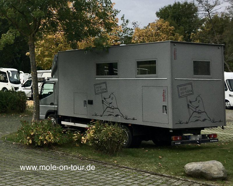
Another route in Germany, possibly in autumn.
You can follow our trips on our blog www.mole-on-tour.de
(Harz, Baltic Sea, Meissen, Dresden, Saxon Switzerland, etc.)
Solms, Deutschland
35606 Solms, Deutschland
50° 33' 7.1" N 8° 24' 59.4" E
50.5519629 8.4165038
• Head east on B49. Go for 17.3 km.
• Take ramp onto B429 toward Wettenberg/Heuchelheim/Gießen. Go for 4.9 km.
• Take ramp onto A480 (Gießener Ring) toward Kassel/Marburg. Go for 14.1 km.
• Take the left exit toward Hannover/Kassel/Fulda onto A5. Go for 22.3 km.
• Take left exit 4 toward Kassel/Dortmund onto A49. Go for 79.5 km.
• Take exit 7 toward Dortmund/Paderborn onto A44. Go for 36.9 km.
• Take exit 65 toward Beverungen/Brakel/Höxter/Warburg. Go for 356 m.
• Continue on B252. Go for 28.6 km.
• Turn right and take ramp toward Brakel/Riesel. Go for 211 m.
• Turn right onto Warburger Straße (K50) toward Brakel/Gewerbegebiet Brakel-Süd/Gewerbegebiet Königsfeld. Go for 1.2 km.
• Turn right onto Am Bahndamm (K50). Go for 844 m.
• Turn right onto Ostheimer Straße (K50). Go for 119 m.
• Turn slightly left onto Am Schützenanger (K18). Go for 862 m.
• Continue on Auf dem Galgenberge (K18). Go for 157 m.
• Continue on Modexen (K18). Go for 2.2 km.
• Continue on Kreisferienstraße (K18) toward Ovenhausen/Bosseborn. Go for 1.2 km.
• Continue on K18. Go for 2.1 km.
• Continue on Modexen (K18). Go for 660 m.
• Continue on K18. Go for 1.1 km.
• Turn left onto L890. Go for 3.0 km.
• Turn right onto Hauptstraße (L755). Go for 3.7 km.
• Take the 2nd exit from roundabout onto Lamfert (K18). Go for 941 m.
• Turn left onto Grasweg. Go for 547 m.
• Arrive at Grasweg. Your destination is on the right.
☍
222,8 km
(2 hrs. 15 min.)
Höxter
Kreis Höxter, Nordrhein-Westfalen, Deutschland
51° 47' 38" N 9° 20' 55.9" E
51.7938902 9.3488550
• Head toward Lamfert on Grasweg. Go for 547 m.
• Turn right onto Lamfert (K18). Go for 864 m.
• Take the 2nd exit from roundabout onto Lütmarser Tal (L755) toward Höxter. Go for 2.7 km.
• Continue on Westerbachstraße (L755). Go for 348 m.
• Continue on Wegetalstraße. Go for 207 m.
• Turn left onto Uferstraße toward Neuhaus i.S./Fürstenberg/Boffzen/Zentrum. Go for 121 m.
• Turn right onto Weserstraße (L755) toward Neuhaus i.S./Fürstenberg/Boffzen. Go for 187 m.
• Turn left onto Im Brückfeld. Go for 389 m.
• Continue on Milchweg. Go for 21 m.
• Arrive at Milchweg. Your destination is on the left.
☍
5,4 km
( 8 min.)
Stellplatz am Floßplatz
Milchweg, 37671, Höxter, Deutschland
51° 46' 27" N 9° 23' 22" E
51.7741667 9.3894444
• Head west on Milchweg. Go for 21 m.
• Continue on Im Brückfeld. Go for 389 m.
• Turn right onto Fürstenberger Straße (L755). Go for 762 m.
• Turn right onto Godelheimer Straße (B64/B83). Go for 27.8 km.
• Turn left onto Scharfoldendorfer Straße (B240) toward Hameln/Hannover/Bodenwerder/Weenzen. Go for 1.7 km.
• Pass 2 roundabouts and continue on B240. Go for 21.6 km.
• Turn left and take ramp onto B3 toward Hannover/Elze. Go for 9.1 km.
• Turn left onto L461. Go for 3.0 km.
• Turn right onto K204 toward Schulenberg. Go for 644 m.
• Continue on K505. Go for 329 m.
• Turn left onto Hallerburger Straße (K506). Go for 1.7 km.
• Continue on K506. Go for 693 m.
• Turn left onto B3. Go for 10.5 km.
• Take ramp toward Sehnde/Laatzen/Gewerbegebiet Pattensen. Go for 318 m.
• Turn right onto Rethener Straße (B443) toward Sehnde/Laatzen/Koldingen. Go for 3.2 km.
• Continue on B443. Go for 2.8 km.
• Keep left onto B443. Go for 2.5 km.
• Take ramp onto A7 toward Hamburg. Go for 97.8 km.
• Take exit 43A toward Schneverdingen/Bispingen. Go for 365 m.
• Take the 3rd exit from roundabout onto Hans-Christoph-Seebohm-Ring (B3) toward A7/Hannover/Celle/Hamburg/Schneverdingen/Heber. Go for 4.2 km.
• Take the 3rd exit from roundabout onto B3 toward Schneverdingen/Heber. Go for 2.6 km.
• Take the 3rd exit from roundabout onto L170 toward Schneverdingen. Go for 848 m.
• Take the 2nd exit from roundabout onto Schneverdinger Straße (L170). Go for 6.6 km.
• Turn right onto Oststraße. Go for 196 m.
• Arrive at Oststraße. Your destination is on the right.
☍
199,7 km
(2 hrs. 30 min.)
Day
Schneverdingen, Deutschland
29640 Schneverdingen, Deutschland
53° 6' 58.4" N 9° 47' 32.4" E
53.1162319 9.7923436
• Head toward Bergstraße on Oststraße. Go for 367 m.
• Turn left onto Harburger Straße (L171). Go for 705 m.
• Take the 1st exit from roundabout onto Weststraße (K31). Go for 190 m.
• Take the 2nd exit from roundabout onto Inseler Straße (K31). Go for 1.2 km.
• Take the 2nd exit from roundabout onto Inseler Straße (K31). Go for 222 m.
• Turn left. Go for 10 m.
• Arrive at your destination on the left.
☍
2,7 km
( 5 min.)
Stellplatz am Quellenbad
Inseler Straße, 29640, Schneverdingen, Deutschland
53° 7' 52" N 9° 46' 22" E
53.1311111 9.7727778
• Head toward Inseler Straße. Go for 10 m.
• Turn right onto Inseler Straße (K31). Go for 186 m.
• Take the 2nd exit from roundabout onto Inseler Straße (K31). Go for 1.2 km.
• Take the 2nd exit from roundabout onto Weststraße (K31). Go for 219 m.
• Take the 3rd exit from roundabout onto Rotenburger Straße (L170). Go for 10.9 km.
• Turn left onto B3. Go for 12.5 km.
• Take the 2nd exit from roundabout onto Hannoversche Straße (B3) toward Hamburg/A1/Bremen/Cuxhaven/Ovelgönne. Go for 6.8 km.
• Take ramp onto A1 toward Flensburg/Kiel/Elbtunnel/Hamburg. Go for 2.7 km.
• Take exit 43 toward Flensburg/Kiel/Hamburg-West/Tötensen/Flughafen onto A261 (Buchholzer Dreieck). Go for 10.3 km.
• Continue on A7. Go for 11.6 km.
• Keep right onto A7. Go for 10.1 km.
• Keep right onto A23 (Autobahndreieck Hamburg-Nordwest) toward Husum/Heide/HH-Eidelstedt. Go for 20.8 km.
• Take exit 14 toward Elmshorn onto B431. Go for 4.9 km.
• Turn right onto Hafenspange. Go for 394 m.
• Continue on Wedenkamp (L100) toward Brunsbüttel/Gluckstadt/Itzehoe/B431. Go for 276 m.
• Turn left onto Gerberstraße (B431) toward Brunsbüttel/Gluckstadt. Go for 10.4 km.
• Take the 3rd exit from roundabout onto L288 toward Kollmar. Go for 625 m.
• Continue on An der Chaussee (L288). Go for 844 m.
• Turn slightly left onto Neuer Weg (L288). Go for 864 m.
• Arrive at Neuer Weg (L288). Your destination is on the left.
☍
105,6 km
(1 hrs. 31 min.)
Day
Am Deich 1A, Kollmar, Deutschland
Am Deich 1A, 25377 Kollmar, Deutschland
53° 43' 31.3" N 9° 29' 20.5" E
53.7253745 9.4890392
• Head toward Am Deich on Neuer Weg (L288). Go for 864 m.
• Turn slightly right onto An der Chaussee (L288). Go for 844 m.
• Continue on L288. Go for 542 m.
• Take the 3rd exit from roundabout onto Langenbrook (B431) toward Brunsbüttel/Glückstadt. Go for 6.6 km.
• Pass 3 roundabouts and continue on Stadtstraße (K8). Go for 1.7 km.
• Take the 2nd exit from roundabout onto Am Fleth (K8). Go for 537 m.
• Turn left onto Am Kommandantengraben. Go for 147 m.
• Turn slightly right onto Am Kommandantengraben. Go for 265 m.
• Continue on Dithmarschenstraße. Go for 45 m.
• Continue on Am Proviantgraben. Go for 143 m.
• Turn right onto Am Hafen. Go for 454 m.
• Arrive at Am Hafen. Your destination is on the right.
☍
12,1 km
( 15 min.)
Day
mit dem Fahrrad in das Umland
Day
Day
Stellplatz Nordermole, Am Hafen 53, 25348 Glückstadt, Deutschland
Am Hafen 53, 25348 Glückstadt, Deutschland
53° 47' 7.3" N 9° 24' 34.9" E
53.7853711 9.4096938
• Head east on Am Hafen. Go for 454 m.
• Turn left onto Am Proviantgraben. Go for 143 m.
• Continue on Dithmarschenstraße. Go for 45 m.
• Continue on Am Kommandantengraben. Go for 399 m.
• Turn left onto Am Neuendeich (K8). Go for 211 m.
• Take the 1st exit from roundabout onto Janssenweg toward Krankenhaus/Bahnhof/Industriegebiet. Go for 763 m.
• Turn right onto Itzehoer Straße. Go for 279 m.
• Arrive at Itzehoer Straße.
☍
2,3 km
( 6 min.)
Glückstadt, Deutschland
25348 Glückstadt, Deutschland
53° 47' 28.3" N 9° 25' 33.9" E
53.7911914 9.4260898
• Head southwest on Itzehoer Straße.
• Turn left onto Bahnhofstraße. Go for 326 m.
• Turn left onto Am Festungsgraben. Go for 150 m.
• Continue on Seidelstraße. Go for 119 m.
• Turn left onto Steinburgstraße (B431). Go for 218 m.
• Turn right onto Itzehoer Straße (B431) toward Brunsbüttel/Itzehoe. Go for 2.2 km.
• Continue on L119. Go for 4.5 km.
• Continue on L119. Go for 5.0 km.
• Turn left onto L112. Go for 202 m.
• Continue on L119. Go for 6.1 km.
• Take the 1st exit from roundabout onto L119 toward Heide/A23/Itzehoe. Go for 250 m.
• Take the 1st exit from roundabout onto A23 toward Heide. Go for 48.5 km.
• Take exit 3 toward Heide/Hemmingstedt. Go for 355 m.
• Turn right onto Hohenheide (B5) toward Brunsbüttel/Meldorf/Hemmingstedt. Go for 2.8 km.
• Turn right onto Büsumer Straße (L238). Go for 324 m.
• Turn left onto Büsumer Straße (L238). Go for 1.7 km.
• Continue on L238. Go for 122 m.
• Continue on Böddinghusen (L238). Go for 91 m.
• Continue on L238. Go for 1.6 km.
• Turn left onto Hauptstraße (L153). Go for 2.6 km.
• Turn right onto Dritter Querweg (K30). Go for 2.7 km.
• Continue on Speicherkoog. Go for 1.7 km.
• Turn left toward Wattweg. Go for 27 m.
• Continue on Wattweg. Go for 457 m.
• Turn left toward Deichstraße. Go for 1.6 km.
• Turn left onto Deichstraße. Go for 745 m.
• Arrive at Deichstraße. Your destination is on the right.
☍
84,3 km
(1 hrs. 5 min.)
Fisch essen beim kleinen Heinrich
Day
Day
Stellplatz am Deich
Deichstraße 2, 25704, Meldorf, Germany
54° 5' 37" N 8° 57' 1" E
54.0936111 8.9502778
• Head north on Deichstraße. Go for 745 m.
• Turn right toward Wattweg. Go for 1.6 km.
• Turn right onto Wattweg. Go for 484 m.
• Turn right onto Speicherkoog. Go for 1.7 km.
• Continue on Dritter Querweg. Go for 1.1 km.
• Turn left onto Koogstraße (K33). Go for 3.1 km.
• Continue on K33. Go for 116 m.
• Continue on Neuer Weg (K33). Go for 1.6 km.
• Turn right onto Chausseestraße. Go for 479 m.
• Turn left onto Allee (L153). Go for 959 m.
• Pass 2 roundabouts and continue on Dohrnstraße (L305). Go for 15.0 km.
• Turn right onto K41. Go for 3.0 km.
• Continue on Katinger Watt (K41). Go for 751 m.
• Continue on K41. Go for 1.9 km.
• Turn right onto Schäferweg (K3). Go for 702 m.
• Continue on Lehnsmann-Siercks-Straße (K3). Go for 1.6 km.
• Turn left onto Olversumer Straße (K3). Go for 147 m.
• Turn right onto Badallee (L241). Go for 233 m.
• Take the 1st exit from roundabout onto Badallee (L241). Go for 357 m.
• Turn right onto Am Freizeitpark. Go for 208 m.
• Arrive at Am Freizeitpark. Your destination is on the left.
☍
35,8 km
( 36 min.)
Day
Stellplatz Eiderblick/Stellplatz Kapitänshaus
Am Freizeitpark, 25832, Tönning, Deutschland
54° 18' 37" N 8° 56' 17" E
54.3102778 8.9380556
• Head toward Wolliner Straße on Am Freizeitpark. Go for 208 m.
• Turn right onto Badallee (L241). Go for 859 m.
• Take the 3rd exit from roundabout onto Gardinger Chaussee (L241). Go for 1.4 km.
• Turn right onto Schrapenbüll (B202). Go for 2.0 km.
• Take ramp onto B5/B202. Go for 18.1 km.
• Take ramp toward Simonsberg/Husum/Hafen-Südufer. Go for 1.2 km.
• Turn right onto Bundesstraße (K137). Go for 1.3 km.
• Turn left onto Gaswerkstraße (L273) toward Niebüll. Go for 442 m.
• Arrive at Gaswerkstraße (L273).
☍
25,4 km
( 23 min.)
Day
mit dem Fahrrad nach St.Peter-Ording
about 45 km there and back
Day
Husumer Hafen, Hafenstraße, Husum, Deutschland
Hafenstraße, 25813 Husum, Deutschland
54° 28' 27.1" N 9° 2' 44.8" E
54.4742046 9.0457912
• Head toward Hafenstraße on Gaswerkstraße (L273). Go for 1.5 km.
• Turn left onto Schobüller Straße (L30). Go for 5.6 km.
• Continue on L30. Go for 41 m.
• Continue on Pohnshalligkoogstraße (L30). Go for 6.3 km.
• Turn left onto Hammchaussee (K80). Go for 3.2 km.
• Continue on Heverweg (K80). Go for 143 m.
• Turn left onto Heverweg. Go for 136 m.
• Arrive at Heverweg. Your destination is on the right.
☍
16,9 km
( 16 min.)
Day
Day
Day
Camping Nordstrand Platz Margarethenruh
Süderhafen 8, 25845, Nordstrand, Germany
54° 28' 8.8" N 8° 54' 37" E
54.4691000 8.9102700
• Head toward Süderhafen on Heverweg. Go for 136 m.
• Turn right onto Heverweg (K80). Go for 143 m.
• Continue on Hammchaussee (K80). Go for 3.2 km.
• Turn right onto Pohnshalligkoogstraße (L30). Go for 6.3 km.
• Continue on L30. Go for 41 m.
• Turn left onto Dorfstraße (K81). Go for 3.0 km.
• Turn left onto Bundesstraße (B5). Go for 6.3 km.
• Turn left onto L278 toward Reußenköge/Hamburger Hallig. Go for 64 m.
• Continue on Wallum Weg (L278). Go for 90 m.
• Continue on Koogchaussee (L278). Go for 66 m.
• Continue on L278. Go for 132 m.
• Continue on Koogchaussee (L278). Go for 2.4 km.
• Continue on Desmerciereskoog (L278). Go for 2.7 km.
• Continue on Cecilienkoog (L278). Go for 2.8 km.
• Continue on Sönke-Nissen-Koog (L278). Go for 3.9 km.
• Turn left onto Sönke-Nissen-Koog (K35). Go for 995 m.
• Arrive at Sönke-Nissen-Koog (K35). Your destination is on the right.
☍
32,2 km
( 28 min.)
Day
Fahrrad fahren am Beltringharder Koog (Vogel - watching)
Day
Stellplatz am Amsinck-Haus
Sönke-Nissen-Koog 36a, 25821, Reußenköge, Germany
54° 36' 56" N 8° 52' 12" E
54.6155556 8.8700000
• Head northeast on Sönke-Nissen-Koog (K35). Go for 995 m.
• Turn left onto Sönke-Nissen-Koog (L11). Go for 4.6 km.
• Continue on Koogstraße (L11). Go for 1.4 km.
• Turn left onto Bäderstraße (L191). Go for 6.0 km.
• Take the 1st exit from roundabout onto Schlüttsiel (L191) toward Dagebüll/Föhr/Amrum. Go for 7.1 km.
• Take the 3rd exit from roundabout onto Nordseestraße (L9). Go for 452 m.
• Arrive at Nordseestraße (L9).
☍
20,6 km
( 18 min.)
Day
Ausflug in's UNESCO-Weltkulturerbe: Nationalpark Schleswig-Holsteinisches Wattenmeer
Day
Dagebüll, Deutschland
54° 43' 48.6" N 8° 42' 19.9" E
54.7301760 8.7055281
• Head west on Nordseestraße (L9). Go for 743 m.
• Turn left onto Am Badedeich. Go for 332 m.
• Arrive at Am Badedeich. Your destination is on the right.
☍
1,1 km
( 2 min.)
Reisemobilhafen am Nordseedeich
Am Badedeich 15, 25899, Dagebüll, Deutschland
54° 43' 36" N 8° 41' 38" E
54.7266667 8.6938889
• Head north on Am Badedeich. Go for 268 m.
• Turn left toward Nordseestraße/L9. Go for 69 m.
• Turn left onto Nordseestraße (L9). Go for 71 m.
• Turn right onto Haffdeich (L9). Go for 79 m.
• Continue on Fährhafenstraße. Go for 619 m.
• Take the 2nd exit from roundabout onto Fährhafenstraße. Go for 737 m.
• Take the 3rd exit from roundabout onto L9 toward Niebüll/Niebel. Go for 3.6 km.
• Continue on L6. Go for 2.4 km.
• Continue on Mitteldeich (L7). Go for 4.1 km.
• Turn left onto Deezbüller Straße (L7) toward Zentrum/Gewerbegebiet Süd/Gewerbegebiet Ost/Sylt. Go for 985 m.
• Turn left onto Mühlenstraße. Go for 153 m.
• Turn right onto Marktstraße. Go for 502 m.
• Turn left onto Böhmestraße. Go for 72 m.
• Turn right. Go for 26 m.
• Turn right. Go for 24 m.
• Arrive at your destination on the left.
☍
13,7 km
( 17 min.)
Day
mit der Fähre nach Föhr
Visit Jasmin, Jens and Jona
Day
evtl. einen ( oder mehrere) weitere Tage auf Föhr
Day
Stellplatz am Marktplatz
Marktstraße, 25899, Niebüll, Germany
54° 47' 17" N 8° 49' 30" E
54.7880556 8.8250000
• Head southeast. Go for 159 m.
• Turn right onto Lornsenstraße. Go for 140 m.
• Continue on Brandkuhle (K114). Go for 145 m.
• Take the 1st exit from roundabout onto Osterweg (K114). Go for 733 m.
• Turn left onto Peter-Schmidts-Weg (L7) toward A7/B5/Gewerbegebiet Süd/Gewerbegebiet Ost. Go for 235 m.
• Pass 2 roundabouts and continue on Peter-Schmidts-Weg (L7). Go for 685 m.
• Turn right onto Peter-Schmidts-Weg (K115). Go for 1.7 km.
• Continue on Siewert-Agsens-Wäi (K115). Go for 1.5 km.
• Continue on Naie Wäi (K115). Go for 2.6 km.
• Continue on Leckeng (K115). Go for 2.0 km.
• Continue on Birkstraße (K115). Go for 1.4 km.
• Turn right onto Hauptstraße (B199). Go for 16.1 km.
• Take the 2nd exit from roundabout onto Hauptstraße (B199). Go for 16.2 km.
• Continue on Zur Exe (K28) toward Centrum. Go for 1.8 km.
• Turn right onto Heinrichstraße (L249). Go for 353 m.
• Continue on Hafermarkt (L249). Go for 25 m.
• Continue on Bismarckstraße (L249). Go for 1.2 km.
• Continue on Mürwiker Straße (L249). Go for 304 m.
• Turn left onto Am Volkspark. Go for 192 m.
• Turn left onto Am Wasserturm. Go for 254 m.
• Arrive at Am Wasserturm. Your destination is on the left.
☍
47,8 km
( 51 min.)
Day
Flensburg, Deutschland
54° 47' 37.5" N 9° 26' 49.2" E
54.7937431 9.4469964
• Head north on Am Wasserturm. Go for 254 m.
• Turn right onto Am Volkspark. Go for 192 m.
• Turn right onto Mürwiker Straße (L249). Go for 304 m.
• Turn right onto Am Lautrupsbach. Go for 562 m.
• Continue on Unterer Lautrupweg. Go for 91 m.
• Turn right onto Ballastbrücke (K6). Go for 854 m.
• Turn left onto Am Industriehafen. Go for 259 m.
• Turn right onto Harniskai. Go for 273 m.
• Arrive at Harniskai. Your destination is on the left.
☍
2,8 km
( 5 min.)
Stellplatz im Industriehafen
Harniskai, 24937, Flensburg, Deutschland
54° 48' 12" N 9° 26' 22" E
54.8033333 9.4394444
• Head south on Harniskai. Go for 273 m.
• Turn left onto Am Industriehafen. Go for 259 m.
• Turn left onto Kielseng (K6). Go for 1.5 km.
• Continue on Mürwiker Straße (L249). Go for 384 m.
• Continue on Mürwiker Straße (L249). Go for 7.1 km.
• Turn left onto Flensburger Straße (K94). Go for 184 m.
• Continue on Schloßallee (K94). Go for 225 m.
• Turn left onto Am Schloßsee. Go for 71 m.
• Arrive at Am Schloßsee.
☍
10,1 km
( 12 min.)
Day
Day
Schloss Glücksburg, Glücksburg (Ostsee), Deutschland
24960 Glücksburg (Ostsee), Deutschland
54° 49' 55.1" N 9° 32' 36.6" E
54.8319665 9.5435123
• Head east on Am Schloßsee. Go for 71 m.
• Turn left onto Schloßallee (K94). Go for 208 m.
• Turn right onto Bahnhofstraße (K93). Go for 706 m.
• Continue on Rüder Straße (K93). Go for 1.1 km.
• Continue on Rüder Straße (K93). Go for 36 m.
• Continue on Glücksburger Straße (K93). Go for 404 m.
• Continue on Dorfstraße (L96). Go for 181 m.
• Turn left onto Am Mühlenberg (K93). Go for 351 m.
• Continue on K93. Go for 827 m.
• Continue on Kragholm (K93). Go for 98 m.
• Continue on Glücksburger Straße (K93). Go for 1.4 km.
• Turn left onto Nordstraße (B199). Go for 2.7 km.
• Turn left onto Hauptstraße (K97) toward Westerholz/Langballig. Go for 266 m.
• Turn left onto Schwarze Straße. Go for 179 m.
• Arrive at Schwarze Straße. Your destination is on the left.
☍
8,6 km
( 10 min.)
mit Stadtbesichtigung von Glücksburg, der nördlichsten Stadt Deutschlands
Day
Langballig, Deutschland
24977 Langballig, Deutschland
54° 47' 57" N 9° 38' 3.5" E
54.7991735 9.6343028
• Head east on Schwarze Straße. Go for 179 m.
• Turn left onto Hauptstraße (K97). Go for 830 m.
• Continue on K97. Go for 1.2 km.
• Continue on Langballigauer Straße (K97). Go for 780 m.
• Continue on K97. Go for 256 m.
• Continue on Haffstraße (K97). Go for 563 m.
• Turn left onto Kummle. Go for 80 m.
• Turn left onto Kummle. Go for 22 m.
• Turn left. Go for 22 m.
• Turn right. Go for 24 m.
• Arrive at your destination on the left.
☍
4,0 km
( 5 min.)
WOMO-Stellplatz, 24977 Westerholz, Deutschland
24977 Westerholz, Deutschland
54° 49' 11.5" N 9° 39' 58.3" E
54.8198616 9.6662074
• Head east. Go for 24 m.
• Turn left toward Kummle. Go for 22 m.
• Turn right onto Kummle. Go for 22 m.
• Turn right onto Kummle. Go for 80 m.
• Turn right onto Haffstraße (K97). Go for 563 m.
• Continue on K97. Go for 256 m.
• Turn right onto Am Hafen. Go for 72 m.
• Turn right onto Strandweg. Go for 448 m.
• Arrive at Strandweg. Your destination is on the right.
☍
1,5 km
( 2 min.)
altern. Camping Langballigau
High season (23.05 - 6.06 // 24.06 - 04.09) + €1
Parking space €10 / electricity extra
Strandweg 3, 24977, Langballigau, Germany
54° 49' 17.8" N 9° 39' 31.8" E
54.8216100 9.6588400
• Head west on Strandweg. Go for 448 m.
• Turn left onto Am Hafen. Go for 72 m.
• Turn left onto K97. Go for 256 m.
• Continue on Haffstraße (K97). Go for 4.9 km.
• Turn left onto An der Nordstraße (B199). Go for 22.9 km.
• Turn left onto Kieholm (L277) toward Maasholm/Hasselberg. Go for 719 m.
• Continue on Baggelan (L277). Go for 930 m.
• Continue on Wulfsholz (L277). Go for 824 m.
• Continue on Wormshöft (L277). Go for 379 m.
• Continue on L277. Go for 501 m.
• Turn slightly right onto Exhöft (L277). Go for 752 m.
• Continue on L277. Go for 112 m.
• Continue on Wormshöfter Damm (L277). Go for 716 m.
• Continue on Schmiedestraße (L277). Go for 45 m.
• Turn left onto Uleweg. Go for 373 m.
• Turn left. Go for 111 m.
• Turn left. Go for 16 m.
• Arrive at your destination on the right.
☍
34,1 km
( 34 min.)
Day
Reisemobilplatz Maasholm, 24404 Maasholm, Deutschland
24404 Maasholm, Deutschland
54° 41' 0.5" N 9° 59' 41.1" E
54.6834602 9.9947568
• Head south. Go for 16 m.
• Turn right toward Uleweg. Go for 111 m.
• Turn right onto Uleweg. Go for 373 m.
• Turn right onto Schmiedestraße (L277). Go for 45 m.
• Continue on Wormshöfter Damm (L277). Go for 716 m.
• Continue on L277. Go for 112 m.
• Continue on Exhöft (L277). Go for 752 m.
• Turn slightly left onto L277. Go for 501 m.
• Continue on Wormshöft (L277). Go for 379 m.
• Continue on Wulfsholz (L277). Go for 824 m.
• Continue on Baggelan (L277). Go for 930 m.
• Continue on Kieholm (L277). Go for 719 m.
• Turn left onto Nordstraße (B199). Go for 5.0 km.
• Take the 2nd exit from roundabout onto Nordstraße (B199) toward A7/Schleswig/Eckernförde/Hafen Kappeln. Go for 1.6 km.
• Turn left onto Bundesstraße (B203) toward Eckernförde/Gewerbegebiet Loitmark. Go for 1.7 km.
• Turn left onto Ostseestraße toward Olpenitz/Weidefelder Strand/Ellenberg. Go for 676 m.
• Turn right onto Ostseestraße. Go for 4.1 km.
• Take the 2nd exit from roundabout onto Schleiufer. Go for 539 m.
• Turn slightly right onto Schleidamm. Go for 642 m.
• Continue on Am Yachthafen. Go for 409 m.
• Turn left onto Am Yachthafen. Go for 38 m.
• Turn right onto Auf der Ostsee. Go for 279 m.
• Arrive at Auf der Ostsee.
☍
20,5 km
( 31 min.)
Schleimündung, 24376 Kappeln, Deutschland
by bike to the mouth of the slime, approx. 3 km from the parking space
24376 Kappeln, Deutschland
54° 40' 48.3" N 10° 2' 1.1" E
54.6800771 10.0336275
• Head toward Albatrosweg on Auf der Ostsee. Go for 279 m.
• Turn left onto Am Yachthafen. Go for 38 m.
• Turn right onto Am Yachthafen. Go for 409 m.
• Continue on Schleidamm. Go for 642 m.
• Turn slightly left onto Schleiufer. Go for 489 m.
• Take the 1st exit from roundabout onto Ostseestraße. Go for 4.2 km.
• Turn left onto Ostseestraße. Go for 632 m.
• Turn right onto B203. Go for 501 m.
• Continue on B201. Go for 488 m.
• Turn right onto Am Hafen toward Gewerbegebiet Nordhafen. Go for 336 m.
• Turn left onto Dehnthof. Go for 127 m.
• Turn right onto Kirchstraße. Go for 202 m.
• Turn left onto Gartenstraße. Go for 107 m.
• Turn right onto Wassermühlenstraße. Go for 18 m.
• Arrive at Wassermühlenstraße. Your destination is on the right.
☍
8,4 km
( 17 min.)
Kappeln
Schleswig-Flensburg, Schleswig-Holstein, Deutschland
54° 39' 51" N 9° 55' 54.3" E
54.6641769 9.9317595
• Head north on Wassermühlenstraße. Go for 669 m.
• Take the 1st exit from roundabout onto Nordstraße (B199). Go for 253 m.
• Turn right onto Grauhöfter Weg. Go for 629 m.
• Arrive at Grauhöfter Weg. Your destination is on the left.
☍
1,6 km
( 3 min.)
Stellplatz Kappeln Nordhafen
Am Hafen 23, 24376, Kappeln, Germany
54° 40' 2" N 9° 56' 14" E
54.6672222 9.9372222
• Head north on Grauhöfter Weg. Go for 629 m.
• Turn left onto Nordstraße (B199). Go for 227 m.
• Take the 2nd exit from roundabout onto Nordstraße (B199) toward A7/Schleswig/Eckernförde/Hafen Kappeln. Go for 1.6 km.
• Turn right onto Kappelholz (B201) toward A7/Schleswig/Süderbrarup. Go for 29.4 km.
• Turn left onto Sankt-Jürgener-Straße (K129) toward Gewerbegebiet St. Jürgen. Go for 1.5 km.
• Take the 2nd exit from roundabout onto Sankt-Jürgener-Straße (K129). Go for 639 m.
• Turn right onto Mühlenredder (K129). Go for 606 m.
• Turn left onto Kattenhunder Weg (K63). Go for 1.2 km.
• Continue on Plessenstraße. Go for 329 m.
• Turn right. Go for 22 m.
• Arrive at your destination on the right.
☍
36,1 km
( 36 min.)
zum Restaurant Stark Am Hafen 20, 24376 Kappeln
Day
Schleswig
Am Hafen, Schleswig, Schleswig-Flensburg, Schleswig-Holstein, Deutschland
54° 30' 43.1" N 9° 34' 4.7" E
54.5119710 9.5679693
• Head south.
• Turn left. Go for 56 m.
• Arrive at your destination on the left.
☍
0,1 km
( )
Wohnmobilstellplatz am Stadthafen
Am Hafen 5, 24837, Schleswig, Germany
54° 30' 42" N 9° 34' 7" E
54.5116667 9.5686111
• Head northeast. Go for 56 m.
• Turn right toward Plessenstraße. Go for 22 m.
• Turn left onto Plessenstraße. Go for 329 m.
• Turn left onto Königstraße (K63). Go for 1.4 km.
• Continue on Gottorfer Damm (K1). Go for 491 m.
• Take ramp onto B76 toward Hamburg/A7/Itzehoe/B77/Kiel. Go for 1.8 km.
• Take ramp toward Kiel/Eckernförde. Go for 262 m.
• Take the 4th exit from roundabout onto Haddebyer Chaussee (B76) toward Kiel/Eckernförde/Flensburg. Go for 1.0 km.
• Turn right. Go for 218 m.
• Turn slightly left. Go for 88 m.
• Arrive at your destination on the right.
☍
5,8 km
( 9 min.)
Day
Wikinger Museum Busdorf
Am Haddebyer Noor 3, Busdorf, Schleswig-Flensburg, Schleswig-Holstein, Deutschland
54° 29' 55.7" N 9° 34' 13.8" E
54.4988192 9.5704938
• Head northwest. Go for 306 m.
• Turn right onto Haddebyer Chaussee (B76). Go for 18.8 km.
• Turn left onto Schulweg toward Zentrum. Go for 372 m.
• Turn right onto Reeperbahn (L26). Go for 572 m.
• Turn left onto Preußerstraße. Go for 98 m.
• Turn left onto Am Exer. Go for 258 m.
• Turn right onto Jungfernstieg. Go for 234 m.
• Turn left onto Taterberg. Go for 89 m.
• Continue on Mühlenstraße. Go for 120 m.
• Arrive at Mühlenstraße. Your destination is on the right.
☍
20,9 km
( 23 min.)
Day
Eckernförde, Deutschland
54° 28' 8.2" N 9° 50' 18.4" E
54.4689457 9.8384467
• Head south on Mühlenstraße. Go for 23 m.
• Turn left toward Jungfernstieg. Go for 31 m.
• Turn right onto Jungfernstieg. Go for 104 m.
• Continue on Kieler Straße. Go for 38 m.
• Continue on Gerichtstraße. Go for 107 m.
• Turn left onto Reeperbahn (L26). Go for 479 m.
• Turn right onto Flensburger Straße (B76/B203). Go for 151 m.
• Arrive at Flensburger Straße (B76/B203). Your destination is on the right.
☍
0,9 km
( 2 min.)
Stellplatz Grüner Weg
Grüner Weg, 24340, Eckernförde, Deutschland
54° 27' 54" N 9° 50' 10" E
54.4650000 9.8361111
• Head northwest on Flensburger Straße (B76/B203).
• Turn left onto Kakabellenweg. Go for 173 m.
• Arrive at Kakabellenweg. Your destination is on the right.
☍
0,2 km
( )
Alternativ: Wohnmobilstellplatz am Noor, Kakabellenweg, 24340 Eckernförde, Deutschland
Kakabellenweg, 24340 Eckernförde, Deutschland
54° 27' 51.9" N 9° 50' 0.4" E
54.4644033 9.8334511
• Head northeast on Kakabellenweg. Go for 173 m.
• Turn right onto Flensburger Straße (B76/B203). Go for 6.2 km.
• Take ramp toward Surendorf/Kiel Nebenstrecke/Flughafen Kiel. Go for 491 m.
• Continue on L285. Go for 9.3 km.
• Continue on L45 toward Kiel/Surendorf/Flughafen Kiel. Go for 4.6 km.
• Continue on B503. Go for 3.2 km.
• Take ramp toward Strande/Dänischenhagen/Scharnhagen. Go for 272 m.
• Turn left onto Strander Straße. Go for 44 m.
• Continue on Dänischenhagener Straße. Go for 40 m.
• Continue on Strander Straße (K18). Go for 2.1 km.
• Take the 1st exit from roundabout onto Fördestraße (K16). Go for 1.1 km.
• Turn left onto Soling. Go for 123 m.
• Turn left. Go for 51 m.
• Arrive at your destination on the left.
☍
27,6 km
( 23 min.)
Day
Wohnmobilstellplatz Olympiahafen, Drachenbahn 19, 24159 Kiel, Deutschland
Drachenbahn 19, 24159 Kiel, Deutschland
54° 25' 49.8" N 10° 9' 57.6" E
54.4305000 10.1660000
• Head toward Soling. Go for 51 m.
• Turn right onto Soling. Go for 123 m.
• Turn left onto Fördestraße (K17). Go for 3.1 km.
• Continue on Fördestraße (K17). Go for 2.1 km.
• Take ramp onto B503 toward Kiel-Zentrum. Go for 6.1 km.
• Continue on Olof-Palme-Damm (B76). Go for 1.2 km.
• Take ramp onto Eckernförder Straße (L321) toward Kronshagen-Nord/Kiel-Zentrum. Go for 1.9 km.
• Turn left onto Möllingstraße toward Altstadt/Sparkassen-Arena/Exerzierplatz. Go for 201 m.
• Turn right onto Stiftstraße. Go for 114 m.
• Turn right onto Eckernförder Straße. Go for 208 m.
• Arrive at Eckernförder Straße. Your destination is on the left.
☍
15,0 km
( 16 min.)
Kiel, Deutschland
54° 19' 23.9" N 10° 7' 22" E
54.3232927 10.1227652
• Head toward Möllingstraße on Eckernförder Straße. Go for 14 m.
• Turn right onto Möllingstraße. Go for 281 m.
• Turn left onto Knooper Weg (K12) toward Holtenauer Str. Go for 1.9 km.
• Turn right onto Knooper Weg. Go for 47 m.
• Turn left onto Holtenauer Straße (K29). Go for 1.9 km.
• Turn right onto Mercatorstraße (K7). Go for 292 m.
• Turn left onto Feldstraße (K15). Go for 224 m.
• Turn right onto Adalbertstraße. Go for 155 m.
• Turn right onto Weimarer Straße. Go for 169 m.
• Turn left onto Rostocker Straße. Go for 405 m.
• Turn right onto Zeyestraße. Go for 219 m.
• Turn left onto Mecklenburger Straße. Go for 363 m.
• Turn right onto Mecklenburger Straße. Go for 134 m.
• Arrive at Mecklenburger Straße. Your destination is on the left.
☍
6,1 km
( 12 min.)
Wohnmobilplatz Förde- und Kanalblick
Mecklenburger Straße 58, 24103, Kiel, Germany
54° 21' 50" N 10° 8' 50" E
54.3638889 10.1472222
• Head west on Mecklenburger Straße. Go for 12 m.
• Turn slightly left onto Dresdener Straße. Go for 366 m.
• Continue on Brandenburger Straße. Go for 378 m.
• Take the 2nd exit from roundabout onto Brandenburger Straße. Go for 433 m.
• Turn right onto Brandenburger Straße. Go for 72 m.
• Turn right onto Kiellinie (K7). Go for 171 m.
• Make a U-Turn at Schweriner Straße onto Kiellinie (K7). Go for 1.6 km.
• Turn right onto Lindenallee. Go for 83 m.
• Turn left onto Lindenallee. Go for 28 m.
• Turn slightly right onto Kiellinie. Go for 790 m.
• Continue on Düsternbrooker Weg (K7). Go for 1.4 km.
• Turn left toward Ostseekai. Go for 32 m.
• Continue on Ostseekai. Go for 190 m.
• Arrive at Ostseekai. Your destination is on the left.
☍
5,5 km
( 10 min.)
Ostseekai, Wall 68, 24103 Kiel, Deutschland
Wall 68, 24103 Kiel, Deutschland
54° 19' 30.8" N 10° 8' 44.3" E
54.3252180 10.1456484
• Head toward Düsternbrooker Weg on Ostseekai. Go for 222 m.
• Turn left onto Düsternbrooker Weg (K7). Go for 196 m.
• Continue on Wall (L321). Go for 2.5 km.
• Turn right onto Bahnhofstraße (L52). Go for 404 m.
• Continue on Joachimplatz. Go for 38 m.
• Turn left onto Theodor-Heuss-Ring. Go for 521 m.
• Take ramp toward Plön. Go for 346 m.
• Continue on Konrad-Adenauer-Damm (B76). Go for 25.8 km.
• Turn right onto Hamburger Straße (B430) toward Neumünster/Ascheberg/Zentrum. Go for 935 m.
• Arrive at Hamburger Straße (B430). Your destination is on the right.
☍
30,9 km
( 26 min.)
Day
mit dem Fahrrad nach Kiel
about 6 km to the town hall in the center
Day
Wohnmobilstellplatz Hamburger Str. 26, 24306 Plön, Deutschland
Hamburger Str. 26, 24306 Plön, Deutschland
54° 9' 14.6" N 10° 24' 22.1" E
54.1540584 10.4061450
• Head toward Schloßgebiet on Hamburger Straße (B430). Go for 916 m.
• Turn right onto B76/B430 toward Lübeck/Eutin/Fehmarn/Lütjenburg/Fähre Fegetasche. Go for 923 m.
• Turn left onto Lütjenburger Straße (B430) toward Fehmarn/Lütjenburg. Go for 18.1 km.
• Turn right and take ramp onto B202 toward Fehmarn/Oldenburg. Go for 1.7 km.
• Turn left onto L164 toward Hohwacht. Go for 1.9 km.
• Continue on Eichenallee (L164). Go for 1.6 km.
• Continue on Haßberg (L164). Go for 1.4 km.
• Continue on L164. Go for 225 m.
• Continue on Am Buchholz (L164). Go for 1.3 km.
• Turn left onto Krähenholt. Go for 144 m.
• Arrive at Krähenholt.
☍
28,3 km
( 27 min.)
Day
Hohwacht Wohnmobilstellplatz
Krähenholt 16a, Hohwacht, Plön, Schleswig-Holstein, Deutschland
54° 19' 10.1" N 10° 40' 33.4" E
54.3194718 10.6759438
• Head southwest on Krähenholt. Go for 144 m.
• Turn right onto Am Buchholz (L164). Go for 1.3 km.
• Continue on L164. Go for 225 m.
• Turn left onto K45. Go for 5.4 km.
• Turn left onto Lütjenburger Straße (B202). Go for 13.9 km.
• Take ramp onto A1 toward Fehmarn. Go for 14.4 km.
• Continue on B207. Go for 5.1 km.
• Take ramp toward Großenbrode. Go for 117 m.
• Turn right onto Nordlandstraße (K42) toward Großenbrode. Go for 402 m.
• Turn left onto Schmiedestraße. Go for 659 m.
• Turn slightly left onto Großenbroderfelde. Go for 1.5 km.
• Continue on Großenbroderfähre. Go for 1.1 km.
• Arrive at Großenbroderfähre. Your destination is on the left.
☍
44,2 km
( 36 min.)
Parkplatz Großenbroderfähre
Next to
Spahn's Grillhus at the port of Großenbrode FerryFerry, 23775 Großenbrode
Fehmarnsund Bridge (963 m long steel bridge with 2 arches that connects the island of Fehmarn with the mainland)
look
Ostholstein, Schleswig-Holstein, Deutschland
54° 23' 31.1" N 11° 7' 4.6" E
54.3919703 11.1179423
• Head northeast on Großenbroderfähre.
• Turn right onto Großenbroderfähre. Go for 69 m.
• Turn right onto Rethsollskamp. Go for 137 m.
• Turn left onto Großenbroderfähre. Go for 1.1 km.
• Continue on Großenbroderfelde. Go for 1.5 km.
• Turn slightly right onto Schmiedestraße. Go for 659 m.
• Turn right onto Nordlandstraße (K42). Go for 649 m.
• Take ramp onto B207. Go for 5.4 km.
• Continue on A1. Go for 46.5 km.
• Take exit 16 toward Scharbeutz. Go for 368 m.
• Turn left onto B76/B432 toward Scharbeutz. Go for 1.6 km.
• Turn right onto Strandallee (B76) toward Lübeck-Travemünde/Timmendorfer Strand. Go for 473 m.
• Turn right onto Hamburger Ring (B76). Go for 1.0 km.
• Take the 2nd exit from roundabout onto Hamburger Ring (B76) toward Lübeck-Travemünde. Go for 11.7 km.
• Take left ramp onto B75 toward Lübeck-Travemünde/Priwall. Go for 1.3 km.
• Continue on Gneversdorfer Weg (B75) toward Priwall/Lübeck-Travemünde. Go for 1.2 km.
• Turn right onto Travemünder Landstraße (K22). Go for 206 m.
• Turn left. Go for 54 m.
• Turn left. Go for 73 m.
• Arrive at your destination on the left.
☍
74,0 km
( 53 min.)
Day
Am Fischereihafen Travemünde
Travemünder Landstraße 324A, Lübeck, Schleswig-Holstein, Deutschland
53° 57' 23.1" N 10° 51' 33.5" E
53.9564214 10.8593055
• Head west. Go for 73 m.
• Turn right toward Travemünder Landstraße/K22. Go for 54 m.
• Turn right onto Travemünder Landstraße (K22). Go for 206 m.
• Turn left onto Gneversdorfer Weg (B75). Go for 1.2 km.
• Continue on B75. Go for 8.4 km.
• Take ramp onto Travemünder Landstraße (B75/B104) toward Rostock/Schwerin/Lübeck-Zentrum. Go for 7.6 km.
• Turn right onto Falkenstraße. Go for 1.3 km.
• Continue on Hüxtertorallee. Go for 23 m.
• Turn right onto Hüxterdamm (K16). Go for 257 m.
• Continue on Hüxterdamm. Go for 77 m.
• Turn left onto An der Mauer. Go for 85 m.
• Turn right onto Krähenstraße. Go for 161 m.
• Continue on Wahmstraße. Go for 300 m.
• Arrive at Wahmstraße. Your destination is on the left.
☍
19,8 km
( 19 min.)
Day
Lübeck, Deutschland
53° 51' 55.7" N 10° 41' 11.6" E
53.8654673 10.6865593
• Head west on Wahmstraße.
• Turn right onto Königstraße. Go for 98 m.
• Turn right onto Hüxstraße. Go for 437 m.
• Turn slightly left onto Hüxterdamm. Go for 77 m.
• Turn left onto Kanalstraße (K16). Go for 1.2 km.
• Turn left onto An der Untertrave. Go for 544 m.
• Turn right onto Willy-Brandt-Allee. Go for 176 m.
• Keep left onto Willy-Brandt-Allee. Go for 244 m.
• Turn left onto Lastadie. Go for 47 m.
• Turn left onto Lastadie. Go for 52 m.
• Arrive at Lastadie. Your destination is on the left.
☍
2,9 km
( 10 min.)
Stellplatz am Parkplatz P4
We already know this parking space
Lastadie, 23554, Lübeck, Germany
53° 52' 18" N 10° 40' 45" E
53.8716667 10.6791667
• Head southwest on Lastadie. Go for 52 m.
• Turn right onto Lastadie. Go for 47 m.
• Turn right onto Willy-Brandt-Allee. Go for 184 m.
• Turn sharp right onto Marienstraße. Go for 129 m.
• Continue on Marienbrücke. Go for 195 m.
• Continue on Marienstraße. Go for 110 m.
• Turn right onto Schwartauer Allee (L309). Go for 831 m.
• Turn left onto Bei der Lohmühle (K25) toward Kiel/Bad Segeberg/Stadion Lohmühle. Go for 802 m.
• Turn right onto Stockelsdorfer Straße (K26). Go for 655 m.
• Take ramp onto A1 toward Hamburg/Rostock/A20. Go for 62.3 km.
• Take the left exit toward Bremen/Hannover/HH-Stillhorn onto A1. Go for 15.2 km.
• Continue on Horster Dreieck toward Hannover/Seevetal-Ramelsloh/A7. Go for 1.7 km.
• Continue on A7. Go for 106 km.
• Keep right onto A352 (Dreieck Hannover-Nord) toward Dortmund/Flughafen/Hannover-Nord. Go for 12.5 km.
• Take exit 3 toward Langenhagen onto B522 (Flughafenstraße). Go for 1.3 km.
• Take ramp toward H.-Stöcken/Garbsen/Godshorn/Langenhagen/Stadtmitte/Gewerbegebiet. Go for 227 m.
• Turn left onto Vinnhorster Straße (K326). Go for 3.1 km.
• Turn right onto Schulenburger Landstraße (L380). Go for 243 m.
• Turn left onto Vinnhorster Weg. Go for 2.1 km.
• Continue on Schaumburgstraße. Go for 656 m.
• Continue on Schaumburgstraße. Go for 71 m.
• Turn left onto Alte Herrenhäuser Straße. Go for 6 m.
• Turn right onto Am Großen Garten. Go for 227 m.
• Turn right. Go for 24 m.
• Arrive at your destination on the left.
☍
208,7 km
(1 hrs. 59 min.)
wiedermal Besuch des Restaurant: Seewolf An der Untertrave 91
we hope it still exists after the lockdown
Day
Day
Wohnmobilparkplatz, Am Großen Garten 3, 30419 Hannover, Deutschland
Am Großen Garten 3, 30419 Hannover, Deutschland
52° 23' 22.9" N 9° 41' 33.8" E
52.3896861 9.6927333
• Head toward Am Großen Garten. Go for 24 m.
• Turn left onto Am Großen Garten. Go for 227 m.
• Turn left onto Alte Herrenhäuser Straße. Go for 6 m.
• Turn right onto Schaumburgstraße. Go for 71 m.
• Turn right onto Herrenhäuser Straße. Go for 858 m.
• Continue on Nienburger Straße. Go for 3.9 km.
• Turn right onto Marienstraße (L384). Go for 1.3 km.
• Continue on Hans-Böckler-Allee (L384). Go for 1.1 km.
• Turn right and take ramp onto Messeschnellweg (B3) toward Kassel/Messe. Go for 8.1 km.
• Keep left onto A37 toward Kassel/Hildesheim. Go for 3.9 km.
• Continue on A7. Go for 148 km.
• Take exit 79 toward Marburg/Kassel onto A49 (Südtangente). Go for 86.5 km.
• Take the left exit toward Basel/Frankfurt/Wiesbaden/Gießen onto A5. Go for 22.1 km.
• Take exit 8 toward Dortmund/Wetzlar/Marburg/Gießen onto A480. Go for 14.2 km.
• Take the exit toward Dortmund/B49/Limburg/Wetzlar. Go for 545 m.
• Turn left onto Gießener Ring (B429) toward B45/Dortmund/Frankfurt/B49/Limburg/Wetzlar. Go for 4.6 km.
• Take ramp onto B49 toward Dortmund/A45/Limburg/Wetzlar. Go for 17.7 km.
• Take ramp toward Solms. Go for 276 m.
• Turn right onto L3283 toward Burgsolms. Go for 132 m.
• Turn left and take ramp onto B49 toward A45/Dortmund/Frankfurt a.M./Gießen/Wetzlar. Go for 452 m.
• Arrive at B49. Your destination is on the right.
☍
314,2 km
(2 hrs. 57 min.)
Day
Solms, Deutschland
35606 Solms, Deutschland
50° 33' 7.1" N 8° 24' 59.4" E
50.5519629 8.4165038