From Renningen to Cuxhaven and along the North Sea coast to the island of Föhr and back via Gifhorn to Renningen
Day
Renningen, Deutschland
Hauptstraße 30, 71272 Renningen, Deutschland
48° 45' 54.4" N 8° 56' 12.1" E
48.7650982 8.9367050
• Head south on Hauptstraße. Go for 45 m.
• Continue on Magstadter Straße. Go for 62 m.
• Pass 2 roundabouts and continue on Magstadter Straße (B464). Go for 914 m.
• Take the 2nd exit from roundabout onto B295 toward Stuttgart/Leonberg/Renningen-Ost. Go for 4.8 km.
• Take ramp onto A8 toward Karlsruhe. Go for 49.9 km.
• Take the exit toward Frankfurt a.M./Mannheim/Karlsruhe/Landau (Pfalz) onto A5 (Autobahndreieck Karlsruhe). Go for 105 km.
• Take the exit toward Hannover/Kassel/Frankfurt/Darmstadt onto A5. Go for 111 km.
• Take left exit 4 toward Kassel/Dortmund onto A49. Go for 79.2 km.
• Take exit 7 toward Hannover/Frankfurt onto A44. Go for 4.7 km.
• Take the left exit toward Hamburg/Hannover/Kassel onto A7. Go for 137 km.
• Take exit 61 toward Hildesheim-Drispenstedt/Hohenhameln/Harsum/Hildesheim. Go for 308 m.
• Turn left onto Kennedydamm (B494) toward Hildesheim. Go for 3.3 km.
• Turn right onto Kaiserstraße (B1) toward Hameln/Seesen. Go for 653 m.
• Arrive at Kaiserstraße (B1). Your destination is on the right.
☍
497,9 km
(4 hrs. 30 min.)
Hildesheim, Deutschland
Kaiserstraße 11, 31134 Hildesheim, Deutschland
52° 9' 20.2" N 9° 57' 0.7" E
52.1556215 9.9501868
• Head toward Schützenallee on Kaiserstraße (B1). Go for 116 m.
• Make a U-Turn at Schützenallee onto Kaiserstraße (B1). Go for 743 m.
• Turn left onto Kennedydamm toward Hannover/B494/Peine. Go for 3.3 km.
• Keep right toward A7. Go for 43 m.
• Take ramp onto A7. Go for 72.8 km.
• Take exit 48 toward Bremen/Walsrode onto A27. Go for 163 km.
• Take the 1st exit from roundabout toward Hamburg/Stade/Otterndorf/Altenbruch. Go for 86 m.
• Continue on B73. Go for 987 m.
• Turn right onto Cuxhavener Chaussee. Go for 767 m.
• Turn left onto Cuxhavener Chaussee. Go for 1.6 km.
• Arrive at your destination on the right.
☍
243,3 km
(2 hrs. 12 min.)
Day
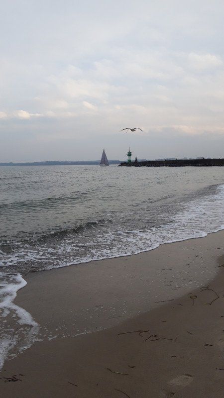
Cuxhaven, Deutschland
Explore the city, eat delicious fish! on to Dune and Döse.
Overlook right by the sea
Unnamed Road, 27472 Cuxhaven, Deutschland
53° 50' 20.6" N 8° 42' 16.6" E
53.8390660 8.7046153
• Head toward Altenbrucher Mühlenweg. Go for 1.1 km.
• Continue on Cuxhavener Chaussee. Go for 539 m.
• Turn right onto Cuxhavener Chaussee. Go for 767 m.
• Turn right onto Cuxhavener Chaussee (B73). Go for 11.9 km.
• Pass 2 roundabouts and continue on B73. Go for 13.3 km.
• Turn left onto Dingwörden (L111) toward Wischhafen/Elbfähre/Freiburg/Geversdorf. Go for 25.7 km.
• Turn right onto Moorchaussee (K13) toward Dösemoor. Go for 243 m.
• Turn left onto Am Ring. Go for 54 m.
• Arrive at Am Ring. Your destination is on the left.
☍
53,6 km
( 47 min.)
Day
Wischhafen, Deutschland
Uhlenkamp 2, 21737 Wischhafen, Deutschland
53° 46' 17.4" N 9° 18' 58.9" E
53.7715061 9.3163716
• Head toward Uhlenkamp on Am Ring. Go for 54 m.
• Turn right onto Moorchaussee (K13). Go for 243 m.
• Turn left onto Stader Straße (B495). Go for 1.2 km.
• Turn right onto Glückstädter Straße (B495) toward Glückstadt/Elbfähre. Go for 1.4 km.
• Take the Glückstadt-Wischhafen Ferry. Stay on for 5.3 km.
• Head north on Op de Wurt. Go for 1.2 km.
• Turn right onto Am Neuendeich (K8) toward Elmshorn/Glückstadt. Go for 1.3 km.
• Take the 2nd exit from roundabout onto Am Neuendeich (K8). Go for 237 m.
• Continue on Am Fleth (K8). Go for 513 m.
• Take the 2nd exit from roundabout onto Stadtstraße (K8). Go for 73 m.
• Take the 3rd exit from roundabout onto Christian-IV-Straße (B431) toward Brunsbüttel/Itzehoe/Elbfähre/Bahnhof/Krankenhaus. Go for 390 m.
• Turn left onto Grönlandstraße. Go for 60 m.
• Continue straight ahead. Go for 68 m.
• Turn right. Go for 16 m.
• Arrive at your destination on the left.
☍
12,0 km
( 50 min.)
Glückstadt, Deutschland
Grönlandstraße 5, 25348 Glückstadt, Deutschland
53° 47' 15.6" N 9° 25' 46.7" E
53.7876597 9.4296299
• Head southwest. Go for 16 m.
• Turn left toward Grönlandstraße. Go for 68 m.
• Continue on Grönlandstraße. Go for 60 m.
• Turn left onto Christian-IV-Straße (B431). Go for 396 m.
• Turn left onto Steinburgstraße (B431) toward Brunsbüttel/Itzehoe/Elbfähre. Go for 390 m.
• Turn right onto Itzehoer Straße (B431) toward Brunsbüttel/Itzehoe. Go for 2.2 km.
• Continue on L119. Go for 4.5 km.
• Continue on L119. Go for 5.0 km.
• Turn left onto L112. Go for 202 m.
• Continue on L119. Go for 6.1 km.
• Take the 1st exit from roundabout onto L119 toward Heide/A23/Itzehoe. Go for 250 m.
• Take the 1st exit from roundabout onto A23 toward Heide. Go for 52.5 km.
• Take ramp toward Heide Krankenhaus/Büsum/Wesselburen. Go for 315 m.
• Turn right onto B203 toward Büsum/Wöhrden/Wesselburen. Go for 4.6 km.
• Pass 2 roundabouts and continue on Heider Straße (B203). Go for 11.6 km.
• Continue on Helgolandkai. Go for 165 m.
• Arrive at Helgolandkai. Your destination is on the left.
☍
88,3 km
(1 hrs. 3 min.)
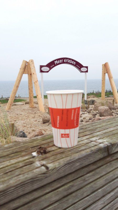
Büsum, Deutschland
The sea his riding and a cup of coffee what more could you want!
Helgolandkai 7, 25761 Büsum, Deutschland
54° 7' 35" N 8° 52' 7.8" E
54.1263955 8.8688358
• Head toward Segeltörn on Helgolandkai. Go for 165 m.
• Continue on Hafentörn (B203). Go for 2.2 km.
• Take the 2nd exit from roundabout onto Bundesstraße (B203). Go for 2.6 km.
• Turn left onto L156. Go for 6.4 km.
• Take the 3rd exit from roundabout onto Eiderstedter Straße. Go for 607 m.
• Continue on Am Stadtpark (K62). Go for 523 m.
• Take the 3rd exit from roundabout onto Dohrnstraße (L305). Go for 18.5 km.
• Continue on L33. Go for 5.3 km.
• Take the 1st exit from roundabout onto Eiderstedter Straße (L33) toward Sankt Peter-Dorf/St. Peter-Bad/St. Peter-Ording/Bahnhof Süd. Go for 1.1 km.
• Turn left onto Schulstraße (K6). Go for 66 m.
• Turn right onto Fasanenweg. Go for 414 m.
• Turn left onto Kirchenleye. Go for 152 m.
• Turn left onto Badallee (K6). Go for 195 m.
• Arrive at Badallee (K6). Your destination is on the right.
☍
38,2 km
( 37 min.)
Day
Sankt Peter-Ording, Deutschland
Badallee 13, 25826 St. Peter-Ording, Deutschland
54° 18' 19.3" N 8° 37' 58.4" E
54.3053589 8.6328963
• Head toward Südallee on Badallee (K6). Go for 221 m.
• Turn left onto Schulstraße (K6). Go for 166 m.
• Continue on Neuweg (K36). Go for 2.3 km.
• Turn right onto Brösumer Straße (B202). Go for 18.4 km.
• Turn left onto Axendorfer Weg (L311). Go for 4.5 km.
• Turn right onto Harblek (L36). Go for 905 m.
• Turn left onto Harblek (L36). Go for 1.0 km.
• Turn left onto Friedrichstädter Chaussee (B5/B202). Go for 16.8 km.
• Take ramp toward A7/Schleswig/Husum/Zentrum. Go for 244 m.
• Turn right onto Schleswiger Chaussee (B201) toward Husum. Go for 372 m.
• Take the 2nd exit from roundabout onto Schleswiger Chaussee toward Husum. Go for 323 m.
• Turn right onto Engelsburger Weg. Go for 144 m.
• Turn left onto Flensburger Chaussee. Go for 379 m.
• Turn right onto Flensburger Chaussee. Go for 108 m.
• Turn right. Go for 43 m.
• Arrive at your destination on the left.
☍
46,0 km
( 41 min.)
Husum, Deutschland
Flensburger Chaussee 41, 25813 Husum, Deutschland
54° 29' 11.9" N 9° 4' 46.8" E
54.4866370 9.0796567
• Head toward Flensburger Chaussee. Go for 43 m.
• Turn right onto Flensburger Chaussee. Go for 78 m.
• Turn right onto Flensburger Chaussee. Go for 73 m.
• Turn left onto Flensburger Chaussee. Go for 101 m.
• Turn right onto Flensburger Chaussee. Go for 287 m.
• Pass 2 roundabouts and continue on Flensburger Chaussee. Go for 1.3 km.
• Take ramp onto Umgehungsstraße (B5) toward Niebüll. Go for 13.2 km.
• Turn left onto L278 toward Reußenköge/Hamburger Hallig. Go for 64 m.
• Continue on Wallum Weg (L278). Go for 90 m.
• Continue on Koogchaussee (L278). Go for 66 m.
• Continue on L278. Go for 132 m.
• Continue on Koogchaussee (L278). Go for 2.4 km.
• Continue on Desmerciereskoog (L278). Go for 2.7 km.
• Continue on Cecilienkoog (L278). Go for 2.8 km.
• Continue on Sönke-Nissen-Koog (L278). Go for 8.5 km.
• Continue on Koogstraße (L11). Go for 1.4 km.
• Turn left onto Bäderstraße (L191). Go for 6.0 km.
• Take the 1st exit from roundabout onto Schlüttsiel (L191) toward Dagebüll/Föhr/Amrum. Go for 7.1 km.
• Take the 2nd exit from roundabout onto Fährhafenstraße. Go for 747 m.
• Take the 2nd exit from roundabout onto Fährhafenstraße toward Fährhafen. Go for 635 m.
• Turn right onto Fährhafenstraße (L9). Go for 224 m.
• Turn left onto Fährhafenstraße (L9). Go for 48 m.
• Turn right onto Fährhafenstraße (L9). Go for 34 m.
• Take the Dagebüll-Wyk auf Föhr-Wittdün Ferry. Stay on for 12.0 km.
• Head southwest on Am Fähranleger (L214). Go for 97 m.
• Turn left onto Am Fähranleger (L214). Go for 252 m.
• Continue on Am Hafen (L214). Go for 802 m.
• Take the 2nd exit from roundabout onto Am Hafen (L214). Go for 263 m.
• Turn right onto But Dörp (K126). Go for 164 m.
• Turn right onto Kreisstraße (K126). Go for 756 m.
• Continue on Kreisstraße (K126). Go for 133 m.
• Arrive at Kreisstraße (K126). Your destination is on the left.
☍
62,4 km
(1 hrs. 35 min.)
Day
Day
Wyk auf Föhr, Deutschland
K126, 25938 Wyk auf Föhr, Deutschland
54° 42' 15.8" N 8° 33' 52.8" E
54.7043911 8.5646669
• Head toward Laglumsweg on Kreisstraße (K126). Go for 133 m.
• Continue on Siedlerweg (K126). Go for 756 m.
• Turn left onto But Dörp (K126). Go for 164 m.
• Turn left onto Am Hafen (L214). Go for 225 m.
• Take the 1st exit from roundabout onto Am Hafen (L214). Go for 837 m.
• Continue on Am Fähranleger (L214). Go for 198 m.
• Turn left onto Am Fähranleger (L214). Go for 151 m.
• Take the Dagebüll-Wyk auf Föhr-Wittdün Ferry. Stay on for 12.0 km.
• Head southeast on Fährhafenstraße (L9). Go for 923 m.
• Take the 2nd exit from roundabout onto Fährhafenstraße. Go for 737 m.
• Take the 2nd exit from roundabout onto L191 toward Bredstedt/Bräist. Go for 7.1 km.
• Take the 3rd exit from roundabout onto Dagebüll Straße (L191). Go for 6.1 km.
• Turn right onto Koogstraße (L11). Go for 1.4 km.
• Continue on Sönke-Nissen-Koog (L11). Go for 7.1 km.
• Continue on Sönke-Nissen-Koog (L278). Go for 1.3 km.
• Continue on Cecilienkoog (L278). Go for 2.8 km.
• Continue on Desmerciereskoog (L278). Go for 2.7 km.
• Continue on Breklumer Koog (L278). Go for 2.4 km.
• Continue on L278. Go for 132 m.
• Continue on Koogchaussee (L278). Go for 66 m.
• Continue on Wallum Weg (L278). Go for 90 m.
• Continue on L278. Go for 64 m.
• Turn right onto Hauptstraße (B5). Go for 30.9 km.
• Turn right onto Harblek (L36) toward Oldenswort. Go for 1.0 km.
• Turn right onto Harblek (L36). Go for 905 m.
• Turn left onto Kotzenbüller Chaussee (L311). Go for 4.5 km.
• Turn left onto Gardinger Chaussee (B202). Go for 3.1 km.
• Take ramp onto B5. Go for 17.5 km.
• Continue on A23. Go for 95.0 km.
• Continue on A7 (Autobahndreieck Hamburg-Nordwest). Go for 7.0 km.
• Keep left onto A7. Go for 21.7 km.
• Keep right onto A39 (Maschener Kreuz) toward Lüneburg/Seevetal-Maschen/Lübeck/Berlin/Bremen/A1. Go for 31.8 km.
• Continue on B4. Go for 6.0 km.
• Take ramp toward Dannenberg/Bleckede/Lüneburg-Neu Hagen/Gewerbegebiet Ost/Hafen/Gewerbegebiet Bilmer Berg. Go for 261 m.
• Turn right onto Dahlenburger Landstraße (B216) toward Dannenberg/Dahlenburg/Bleckede/Gewerbegebiet Ost/Hafen/Gewerbegebiet Bilmer Berg. Go for 504 m.
• Keep left onto Dahlenburger Landstraße (B216) toward Dannenberg/Bleckede/Gewerbegebiet Hafen. Go for 1.0 km.
• Keep left onto Dahlenburger Landstraße (B216) toward Dannenberg. Go for 2.7 km.
• Take the 1st exit from roundabout onto K28 toward Neuhaus (Elbe)/Gewerbegebiet Volkstorf/Vastorf. Go for 3.1 km.
• Take the 2nd exit from roundabout onto K28. Go for 600 m.
• Continue on An der Bahn (K28). Go for 727 m.
• Turn right onto Dorfstraße (K16). Go for 509 m.
• Continue on K16. Go for 1.2 km.
• Continue on K42. Go for 1.0 km.
• Continue on Vastorfer Straße (K42). Go for 623 m.
• Continue on K42. Go for 2.2 km.
• Continue on Niendorfer Hauptstraße (K42). Go for 615 m.
• Continue on K42. Go for 1.0 km.
• Continue on Niendorfer Straße (K42). Go for 901 m.
• Take the 2nd exit from roundabout onto Uelzener Straße (K10). Go for 972 m.
• Turn left onto B4. Go for 15.9 km.
• Take the 3rd exit from roundabout onto B4 toward Braunschweig/Uelzen. Go for 1.9 km.
• Keep left onto B4 toward Braunschweig/B191/Hannover/B71/Salzwedel/Uelzen Gewerbegebiet/Stadtmitte. Go for 14.0 km.
• Pass 2 roundabouts and continue on An der Krümme (B4). Go for 45.3 km.
• Take ramp toward Hannover. Go for 333 m.
• Turn left onto B188 toward Hannover. Go for 1.3 km.
• Turn left onto Celler Straße toward Gifhorn/Stadthalle/Gewerbegebiet Celler Str. Go for 1.2 km.
• Turn right onto Kurze Straße. Go for 79 m.
• Turn left onto Fischerweg. Go for 73 m.
• Turn right onto Säftgenriede. Go for 112 m.
• Turn left onto Im Wiesengrund. Go for 222 m.
• Arrive at Im Wiesengrund. Your destination is on the left.
☍
365,1 km
(4 hrs. 52 min.)
Day
Gifhorn, Deutschland
Fischerweg 11A, 38518 Gifhorn, Deutschland
52° 29' 1.5" N 10° 31' 50.1" E
52.4837539 10.5305971