In June 2017 we, Rina, Gerard, Harry and I went to Italy. Rina and Gerard with a tent and we with the caravan. It was an exhausting, but beautiful journey. We have seen, done, experienced, eaten and driven a lot.
Day
Camping Californië, Horsterweg, Grubbenvorst, Nederland
Horsterweg 23, 5971 ND Grubbenvorst, Nederland
51° 25' 14.4" N 6° 6' 23.9" E
51.4206750 6.1066255
• Head toward Sevenumseweg on Horsterweg. Go for 151 m.
• Turn right onto Venrayseweg. Go for 1.6 km.
• Turn left toward A73. Go for 440 m.
• Take ramp onto A73 toward Venlo/Maastricht/Industrieterrein Venlo 0-3000/4000-9900. Go for 9.1 km.
• Keep left onto A74 (Knooppunt Tiglia) toward Koblenz/Mönchengladbach/Nettetal. Go for 1.9 km.
• Continue on A61. Go for 36.0 km.
• Continue on Autobahndreieck Mönchengladbach-Wanlo toward Koblenz/Aachen/Düsseldorf/A61. Go for 375 m.
• Take the exit onto A46. Go for 3.8 km.
• Take exit 11 toward Koblenz/Köln/Aachen/A61 onto A44. Go for 8.2 km.
• Take exit 16 toward Koblenz/Köln onto A61. Go for 40.7 km.
• Continue on A61 toward Koblenz/Weilerswist. Go for 124 km.
• Take exit 45 toward Rheinböllen/Trier/Simmern/Bacharach/Rhein/Flughafen Hahn onto B50. Go for 610 m.
• Take ramp onto Bahnhofstraße (L214) toward Stromberg. Go for 10.0 km.
• Turn right onto Im Zwengel (L242). Go for 2.1 km.
• Arrive at Naheweinstraße (L242). Your destination is on the right.
☍
238,9 km
(2 hrs. 20 min.)
Reisverslag naar Schweppenhausen
The ride to Schweppenhausen goes smoothly. After arrival we set up the tent for the first time. It rains a little, but the tent is quickly set up. During the journey we become more and more skilled at it and everyone gets their task. We do some shopping and have a nice meal at the campsite. How nice and quiet it is here. You hear the birds in the early morning and an owl the rest of the night. How appropriate is that: Owls listening to owls.
Camping Aumühle Naheweinstraße 65, Schweppenhausen, Duitsland
Naheweinstraße 65, 55444 Schweppenhausen, Duitsland
49° 56' 1.3" N 7° 47' 30.4" E
49.9337000 7.7917900
• Head southeast on Naheweinstraße (L242). Go for 1.1 km.
• Turn left onto Gaustraße (K29). Go for 2.0 km.
• Take the 3rd exit from roundabout onto Windesheimer Straße (L236). Go for 182 m.
• Take the 1st exit from roundabout onto A61 toward Ludwigshafen/Mainz/Bingen. Go for 101 km.
• Take the left exit toward Stuttgart/Heilbronn/Karlsruhe onto A6. Go for 7.8 km.
• Take exit 31 toward Basel/Karlsruhe onto A5. Go for 224 km.
• Continue on A2. Go for 14.1 km.
• Keep right onto A2 (Verzweigung Augst) toward Chiasso/Gotthard/Luzern/Bern/Arisdorf. Go for 28.2 km.
• Take the left exit toward Chiasso/Gotthard/Luzern/Zürich/Rothrist onto A1/A2. Go for 8.9 km.
• Take exit 47 toward Chiasso/Gotthard/Luzern/Reiden onto A2 (Verzweigung Wiggertal). Go for 31.5 km.
• Take exit 21 toward Sempach/Neuenkirch/Hochdorf. Go for 409 m.
• Take the 3rd exit from roundabout onto Schlachtstrasse. Go for 399 m.
• Take the 1st exit from roundabout onto Rainerstrasse. Go for 350 m.
• Continue on Luzernerstrasse. Go for 841 m.
• Turn right onto Seeland. Go for 13 m.
• Continue on Seelandstrasse. Go for 399 m.
• Arrive at Seelandstrasse. Your destination is on the left.
☍
421,6 km
(3 hrs. 48 min.)
Day
Reisverslag naar Sempach
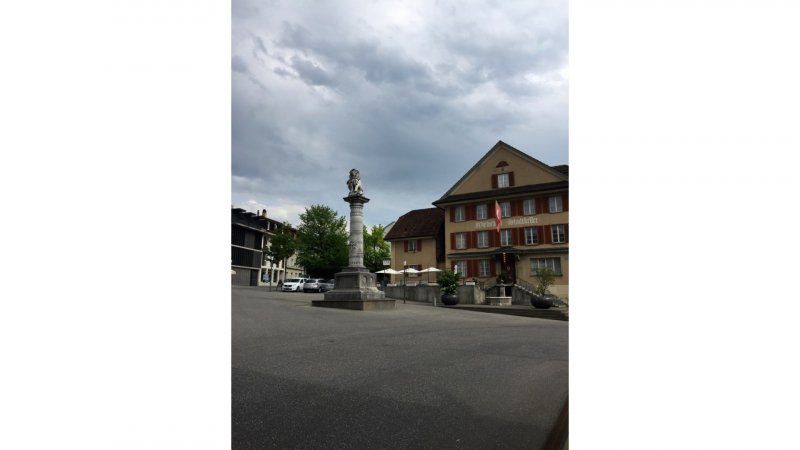
We get up relaxed and have breakfast. The tent is taken down and we leave. We have a nice and fast ride to Sempach. First set up the tent. It's raining hard, so we do that in record time. The power poles cause some problems, but with the help of all neighbors this is quickly resolved. First a cup of coffee. Between the showers we go to Sempach. It's a lovely spot. Not big, but there is a terrace. Oops, the prices are high in Switzerland: almost 25 euros for 4 drinks. But yes, you are on vacation or not!
TCS Camping Sempach
Seelandstrasse 6, 6204, Sempach, Schweiz
47° 7' 28.6" N 8° 11' 22.2" E
47.1246000 8.1895000
• Head northeast on Seelandstrasse. Go for 399 m.
• Continue on Seeland. Go for 13 m.
• Turn left onto Luzernerstrasse. Go for 841 m.
• Continue on Rainerstrasse. Go for 330 m.
• Take the 3rd exit from roundabout onto Schlachtstrasse. Go for 364 m.
• Take ramp onto A2 toward Gotthard/Luzern/Zürich/Interlaken. Go for 197 km.
• Take exit 52 toward Mendrisio. Go for 642 m.
• Take the 1st exit from roundabout toward Novazzano/Arzo. Go for 72 m.
• Take the 2nd exit from roundabout toward Novazzano/Arzo. Go for 1.2 km.
• Take ramp toward Novazzano/Mendrisio. Go for 218 m.
• Take the 1st exit from roundabout onto Via Camerlata (393) toward Novazzano/Mendrisio. Go for 378 m.
• Take the 1st exit from roundabout onto Via Antonio Rinaldi (393) toward Novazzano/Mendrisio. Go for 314 m.
• Take the 1st exit from roundabout onto Via Campagna Adorna. Go for 282 m.
• Take the 2nd exit from roundabout onto Via Canova. Go for 1.3 km.
• Take the 1st exit from roundabout onto Via Cios. Go for 1.0 km.
• Continue on SP23. Go for 1.1 km.
• Pass 6 roundabouts and continue on Via Bizzarone (SP23). Go for 5.5 km.
• Continue toward Milano/Beregazzo/Appiano G./Autostrada/A9. Go for 48 m.
• Take the 2nd exit from roundabout toward Milano/Beregazzo/Appiano G./Autostrada/A9. Go for 85 m.
• Continue on Via per Lomazzo. Go for 1.1 km.
• Pass 6 roundabouts and continue on Via Salvo D'Acquisto (SP23). Go for 5.9 km.
• Take the 3rd exit from roundabout onto Via Italia (SP23) toward Milano-Chiasso/A9/Guanzate/Lomazzo. Go for 1.6 km.
• Take the 3rd exit from roundabout onto Via Roma (SP23) toward Lomazzo/Autostrada/A9. Go for 504 m.
• Pass 2 roundabouts and continue on Via 25 Aprile (SP23). Go for 2.1 km.
• Take the 1st exit from roundabout onto A9 (Autostrada dei Laghi) toward Milano/A8/Milano-Chiasso/Milano-Varese/A8. Go for 14.8 km.
• Take the left exit onto A8 (Autostrada dei Laghi). Go for 5.1 km.
• Take the exit toward E64/Torino/A4/Genova/A7/Bologna/A1 onto A50 (Tangenziale Ovest). Go for 20.5 km.
• Take the exit toward Genova onto A7 (Autostrada Milano-Genova). Go for 18.0 km.
• Take the exit toward Bereguardo/Pavia Nord onto A53 (Raccordo Autostradale Pavia Bereguardo). Go for 8.9 km.
• Take exit 7 toward Pavia Via Riviera/Ospedale. Go for 347 m.
• Continue on Via Adda. Go for 195 m.
• Turn right onto Via San Lanfranco Beccari (SP130). Go for 381 m.
• Continue on Via Mascherpa (SP130). Go for 207 m.
• Arrive at Via Mascherpa (SP130). Your destination is on the right.
☍
291,1 km
(3 hrs. 23 min.)
Day
Reisverslag reisdag en Pavia
We drive out of Sempach in the rain and it is still raining at the Gotthardtunnel. We have a 30 minute traffic jam: that's not too bad. We are alerted to the hatch of the caravan that is open: fortunately there are people who pay such attention.
After the tunnel the sun suddenly shines and it kept shining the whole trip!
After some searching we find the campsite. Welcoming reception and a nice spot. The sanitary facilities are reasonable, the grass is long.
After setting up the caravan and tent, we first go to the city. What a surprise is Pavia:
Pavia has a great wealth of historical and cultural attractions. Pavia was founded on the banks of the river Ticino more than two thousand years ago and is also the city where Charlemagne was crowned emperor. Pavia has a rich history and is still a prosperous city.
Pavia has Roman origins and you can tell by the structure of the center. the streets run perpendicular to each other. The city is made of red stone and this makes the city very colorful and cheerful. Pavia is a real university town, the university is one of the oldest in Italy. Thanks to the university, Pavia is a very lively city with many students. The university is housed in a neoclassical building. If you pass by here, be sure to take a look inside the courtyard. Several faculty buildings are scattered throughout the center. The cathedral of Pavia is also among the many sights. It was built in 1488 by two architects. In a later phase, even Bramante was involved in the construction. The construction took a long time, in the 16th century it was still not finished. The facade and the high dome were only completed in the 19th century.
the San Michele church is a Romanesque building. The church had to be completely rebuilt after the earthquake in the 12th century. A special feature is the gold-coloured façade, which is divided into three vertical zones.
The Collegio Borromeo, founded by Carolus Borromeus, is a 16th century building with a beautiful courtyard.
The Basilica of San Pietro in Ciel d'Ora, like the San Michele Church, is an example of Romanesque architecture in Pavia. Ciel d'Ora means Golden Heaven and the church owes its name to a painting that adorns the apse of an older church. In the church lies the body of the church father Augustine. Augustine's remains arrived in Pavia from North Africa via Sardinia in the 8th century.
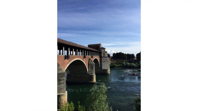
And then of course the Ponte Coperto. At this place you not only have a view of this special covered bridge, but you can also see the Ticino flowing. This river is about 250 kilometers long and flows from Switzerland at Pavia de Po. This river has therefore ensured that Pavia is well connected to the larger cities in the north and central of Italy.
After the walk we have a delicious Italian cappuccino: I know, that's not done in the afternoon! Was delicious anyway.
Camping Ticino
Via Mascherpa 16, 27100, Pavia, Italien
45° 11' 43.1" N 9° 7' 12.4" E
45.1953000 9.1201000
• Head east on Via Mascherpa (SP130). Go for 207 m.
• Continue on Via San Lanfranco Beccari (SP130). Go for 381 m.
• Turn left onto Via Adda toward Tangenziale Ovest/Pavia. Go for 389 m.
• Take left ramp onto A53 (Raccordo Autostradale Pavia Bereguardo) toward Milano/Genova/A7/Staz. Bereguardo. Go for 8.6 km.
• Take the left exit toward Genova onto A7 (Autostrada Milano-Genova). Go for 104 km.
• Take the exit toward Bolzaneto. Go for 794 m.
• Take the 2nd exit from roundabout onto Via Giuseppe Colano (SP35). Go for 364 m.
• Turn right onto Via Monte Cimone. Go for 172 m.
• Turn left onto Via Luigi Boggiano. Go for 67 m.
• Turn right onto Via Pasquale Pastorino (SP35). Go for 2.0 km.
• Take the 2nd exit from roundabout onto Strada Provinciale dei Giovi (SP35). Go for 649 m.
• Keep right onto Via Francesco Campora. Go for 13 m.
• Continue on Via Argine Polcevera. Go for 59 m.
• Turn left onto Via Giorgio Perlasca. Go for 292 m.
• Continue on Via Argine Polcevera. Go for 74 m.
• Continue on Via Giorgio Perlasca. Go for 1.1 km.
• Turn left onto Via Campi. Go for 224 m.
• Turn right onto Strada Provinciale dei Giovi (SP35). Go for 1.7 km.
• Turn left onto Piazza Nicolò Montano (SS1) toward Ospedale Sampierdarena/Centro/Autostrade. Go for 998 m.
• Turn slightly right and take ramp onto Strada Aldo Moro (SS1) toward Centro/Fiera di Genova. Go for 5.0 km.
• Take the 2nd exit from Rotonda 9 Novembre 1989 roundabout onto Viale delle Brigate Partigiane (SS45) toward Piacenza/Stazione F. S. Brignole. Go for 1.1 km.
• Turn left onto Viale Paolo Thaon di Revel toward V. Colombo/V. De Amicis. Go for 138 m.
• Arrive at Viale Paolo Thaon di Revel.
☍
128,7 km
(1 hrs. 35 min.)
Day
Via Genua, Italië
Genua, Italië
44° 24' 20.3" N 8° 56' 46.5" E
44.4056499 8.9462560
• Head toward Via Colombo on Viale Paolo Thaon di Revel. Go for 98 m.
• Turn left onto Via Fiume. Go for 145 m.
• Turn left onto Via Luigi Cadorna. Go for 213 m.
• Turn left onto Viale Emanuele Filiberto Duca d'Aosta (SS45). Go for 176 m.
• Turn right onto Piazza delle Americhe toward Corso Europa/Ospedale S. Martino/Autostrade/La Spezia/Nervi. Go for 89 m.
• Continue on Via Giovanni Tomaso Invrea. Go for 417 m.
• Continue on Piazza Gaetano Alimonda. Go for 63 m.
• Turn slightly right onto Via Odessa. Go for 118 m.
• Turn left onto Via Montevideo. Go for 161 m.
• Continue on Corso Aldo Gastaldi. Go for 3.9 km.
• Keep left onto Corso Europa. Go for 813 m.
• Take ramp toward Livorno/A12. Go for 152 m.
• Turn left onto Cavalcavia Carlo Negri toward Genova/E80/Livorno/A12. Go for 80 m.
• Turn right onto Svincolo Genova Nervi. Go for 1.4 km.
• Take left ramp onto A12 (Autostrada Azzurra) toward Livorno. Go for 29.5 km.
• Take the exit toward Lavagna. Go for 934 m.
• Take the 2nd exit from roundabout onto Via Moggia (SP33). Go for 494 m.
• Take the 2nd exit from Piazza Abate Lazzaro Podestà roundabout onto Piazza Abate Lazzaro Podestà (SP33). Go for 926 m.
• Take the 2nd exit from Piazza Cordeviola roundabout onto Via Cristoforo Colombo (SS1) toward Cavi-La Spezia. Go for 197 m.
• Keep right onto Via Cristoforo Colombo (SS1). Go for 34 m.
• Turn left onto Via Aurelia (SS1). Go for 355 m.
• Pass 2 roundabouts and continue on Via Aurelia (SS1). Go for 5.6 km.
• Take the 3rd exit from Piazza Sant'Antonio roundabout onto Via Aurelia (SS1). Go for 559 m.
• Take the 3rd exit from Via Vincenzo Fascie roundabout onto Via Aurelia (SS1). Go for 196 m.
• Take the 1st exit from roundabout onto Via Aurelia (SS1). Go for 525 m.
• Pass 2 roundabouts and continue on Via Vincenzo Fascie (SS1). Go for 851 m.
• Take the 2nd exit from roundabout onto Via Giorgio Bo toward Autostrada/Casarza Ligure/Varese Ligure/Castiglione Ch./A12. Go for 290 m.
• Take the 2nd exit from roundabout onto Svincolo Sestri Levante toward Genova/A12/Livorno. Go for 146 m.
• Take ramp onto A12 (Autostrada Azzurra) toward Livorno. Go for 26.9 km.
• Take the exit toward Brugnato/Borghetto V. Go for 497 m.
• Take the 3rd exit from roundabout onto Strada Provinciale della Val di Vara (SP566) toward La Spezia/Porto Venere/Cinque Terre. Go for 1.5 km.
• Turn left onto Via Aurelia (SS1). Go for 6.7 km.
• Turn left onto Strada Provinciale della Val di Vara (SP10) toward Ceparana/Sarzana/Calice al Cornovigio/Beverino. Go for 2.0 km.
• Take the 2nd exit from roundabout onto Via Battaglione Zignago (SP10) toward S.Stefano M./SP62/Pian di Follo/Calice al C./SP8/Ceparana/SP13/Piana Battolla/Livorno/A12/Parma/A15/Castiglione. Go for 5.9 km.
• Take the 2nd exit from roundabout onto Località Casalino (SP13) toward Ceparana/S.Stefano M./SP62/Aulla/SS82/Sarzana. Go for 951 m.
• Continue on Via Genova (SP20). Go for 1.9 km.
• Continue on Via Genova (SP13). Go for 2.3 km.
• Turn right onto SP13 toward La Spezia. Go for 9 m.
• Turn slightly right onto Via Italia (SP330). Go for 628 m.
• Take the 2nd exit from roundabout onto Via Italia (SP330). Go for 833 m.
• Continue on Via Provinciale Piana (SP10) toward La Spezia/Vezzano. Go for 29 m.
• Take the 2nd exit from roundabout onto Via Provinciale Piana (SP10) toward Vezzano/La Spezia. Go for 678 m.
• Take the 2nd exit from roundabout onto Via Provinciale Fornola (SP10). Go for 2.8 km.
• Take the 1st exit from roundabout onto Via Aurelia (SS1) toward Genova/A12/Livorno/A15/Parma/La Spezia. Go for 136 m.
• Take ramp onto A15 (Autostrada della Cisa) toward Santo Stefano di Magra/E80/Genova/A12/Livorno/E31/Parma/Rosignano M./Roma. Go for 1.4 km.
• Take the exit toward E80/Genova/A12/Livorno/A12/Rosignano M./Roma/E80/E31/Parma onto A15 (Autostrada della Cisa). Go for 993 m.
• Take the exit toward Livorno/Rosignano M./Roma/E76/Firenze/A11 onto A12 (Autostrada Azzurra). Go for 67.1 km.
• Take the exit toward Pisa Centro/Aeroporto Pisa onto Strada di Grande Comunicazione Fi-Pi-Li. Go for 21.0 km.
• Take left ramp onto Strada di Grande Comunicazione Fi-Pi-Li toward Firenze. Go for 20.4 km.
• Take ramp toward S. Croce sull'Arno. Go for 229 m.
• Take the 1st exit from roundabout onto Viale Leonardo da Vinci (SP44) toward Ponte a Egola/San Miniato/S. Gimignano. Go for 228 m.
• Take the 3rd exit from roundabout onto Via Pruneta. Go for 1.4 km.
• Take the 2nd exit from roundabout onto Via Corrado Pannocchia (SS67). Go for 1.4 km.
• Turn right onto Via Catena. Go for 1.9 km.
• Turn left onto Piazza L. Benvenuti. Go for 109 m.
• Continue on Via delle Casine. Go for 503 m.
• Arrive at Via delle Casine. Your destination is on the right.
☍
218,9 km
(2 hrs. 52 min.)
Reisverslag reisdag
We drive via Genoa to Pisa. On the way we make a stop for coffee and what to do. We only find a gas station where they sell everything, except coffee and whatever. So continue to the campsite. First set up the caravan and the tent again.
Shopping: we try to find a Lidl everywhere and that goes quite well. One more extensive than the other, but available everywhere.
During a walk around the campsite we see a group of travelers from the acsi: such a tour with your own camper or caravan. What is striking is that they are all peeking inside at the TV. How unfortunate that is! There is also the same trip from the ANWB a few days later, and everyone is also peeking at the TV there.
In the evening we have a discussion about the continuation of the trip and decide to take a trip to Elba. We book the boat and discuss a hotel.
Camping Village Torre Pendente Via delle Casine, San Miniato, Pisa, Italië
Via delle Casine, 56028 San Miniato PI, Italië
43° 41' 3.5" N 10° 50' 13.7" E
43.6842949 10.8371358
• Head south on Via delle Casine. Go for 503 m.
• Continue on Piazza L. Benvenuti. Go for 109 m.
• Turn right onto Via Catena. Go for 1.9 km.
• Turn right onto Via Tosco Romagnola Est (SS67). Go for 917 m.
• Take the 3rd exit from roundabout onto Via dei Mille. Go for 176 m.
• Continue toward Via Sanminiatese. Go for 33 m.
• Take the 2nd exit from roundabout onto Via Sanminiatese. Go for 687 m.
• Turn left and take ramp onto Strada di Grande Comunicazione Fi-Pi-Li toward Pisa/Livorno. Go for 33.7 km.
• Take ramp onto A12 (Autostrada Azzurra) toward Roma. Go for 34.0 km.
• Continue on Strada Statale Aurelia (SS1). Go for 39.3 km.
• Take ramp onto Strada Statale della Val di Cornia (SS398) toward Venturina/Sardegna. Go for 7.8 km.
• Take ramp onto Strada della Base Geodetica (SP23bis) toward Piombino/Isola d'Elba. Go for 1.3 km.
• Keep left onto Strada Provinciale Fiorentina-Montegemoli (SP23bis). Go for 214 m.
• Continue on Strada Provinciale della Principessa (SP23). Go for 203 m.
• Keep right onto Località Asca (SP23). Go for 453 m.
• Pass 3 roundabouts and continue on Località Gagno (SP23). Go for 1.6 km.
• Continue on Viale dell'Unità d'Italia. Go for 365 m.
• Pass 2 roundabouts and continue on Viale dell'Unità d'Italia. Go for 1.8 km.
• Turn left onto Viale della Resistenza. Go for 398 m.
• Continue on Via Felice Cavallotti. Go for 154 m.
• Take the 1st exit from roundabout onto Via Portovecchio. Go for 139 m.
• Take the 1st exit from roundabout onto Via Pisa. Go for 236 m.
• Continue on Via Ignazio Silone. Go for 264 m.
• Keep left onto Via Ignazio Silone toward Porto. Go for 57 m.
• Take the 3rd exit from Largo Enzo Tortora roundabout onto Largo Enzo Tortora. Go for 166 m.
• Continue on Viale Regina Margherita. Go for 121 m.
• Take the 1st exit from roundabout onto Piazza Salvadore Allende. Go for 63 m.
• Continue on Via Carlo Alberto Dalla Chiesa. Go for 466 m.
• Continue on Piazzale Premuda. Go for 164 m.
• Take the 2nd exit from roundabout onto Piazzale Premuda. Go for 69 m.
• Turn right. Go for 20 m.
• Turn left. Go for 75 m.
• Take the Piombino-Portoferraio Ferry. Stay on for 26.9 km.
• Head toward Calata Italia on Banchina Capitano Vezio Dini (SP24). Go for 57 m.
• Turn left onto Strada Provinciale Portoferraio Bivio Boni (SP24). Go for 182 m.
• Take the 2nd exit from roundabout onto Viale T. Tesei (SP24). Go for 480 m.
• Take the 3rd exit from roundabout onto Via Cementiera (SP24). Go for 524 m.
• Pass 2 roundabouts and continue on Strada Provinciale Bivio Boni Procchio (SP24). Go for 8.9 km.
• Turn left onto Strada Provinciale Anello Occidentale (SP25) toward Aeroporto/Marina di Campo/Seccheto/Fetovaia/Cavoli. Go for 2.9 km.
• Turn left onto Via dell'Acquedotto. Go for 973 m.
• Continue on Via di Favale. Go for 252 m.
• Take the 2nd exit from roundabout onto Strada Provinciale Anello Occidentale (SP25). Go for 381 m.
• Turn right onto Via Pian di Mezzo. Go for 266 m.
• Turn left onto Via Casalini. Go for 171 m.
• Turn left onto Via Ramazzotto. Go for 99 m.
• Turn right onto Via Ramazzotto. Go for 124 m.
• Turn left onto Via del Renaio. Go for 314 m.
• Turn right onto Strada Provinciale Anello Occidentale (SP25). Go for 475 m.
• Turn right onto Strada Provinciale Anello Occidentale (SP25). Go for 220 m.
• Take the 1st exit from roundabout onto Strada Provinciale Anello Occidentale (SP25). Go for 455 m.
• Take the 2nd exit from roundabout onto Strada Provinciale Anello Occidentale (SP25). Go for 8.2 km.
• Turn left onto Via Fetovaia. Go for 127 m.
• Turn slightly right onto Via del Canaletto. Go for 227 m.
• Arrive at Via del Canaletto. Your destination is on the left.
☍
179,5 km
(3 hrs. 13 min.)
Day
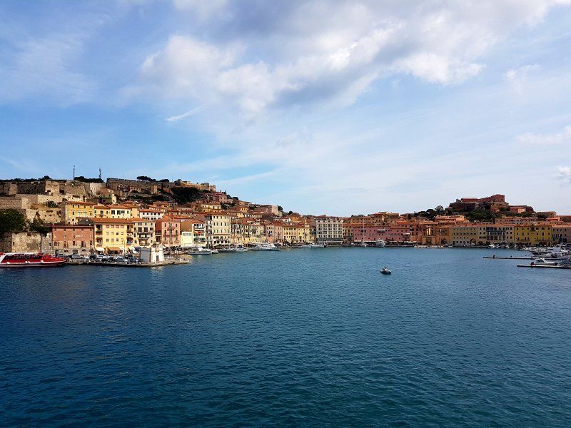
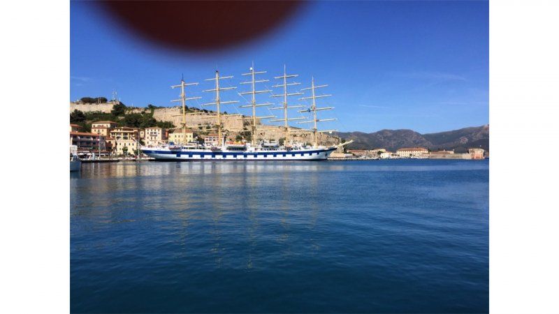
Reisverslag Elba
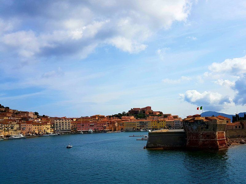
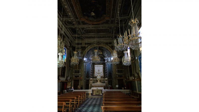
Early in the morning we drive to Piombino, where the boat departs from. By noon we are in Portoferraio. We want to go to Napoleon's house, but it is closed. So then have an ice cream and walk to the Chiesa della Misericordia. Harry does his thing and we listen ;-)
Then we drive south to the hotel. We have a delicious lunch on the way. Harry let his phone stay there a little longer: luckily we find out in time.
Hotel Anna is difficult to find, but what a wonderful hotel it is: friendly, clean and beautiful rooms.
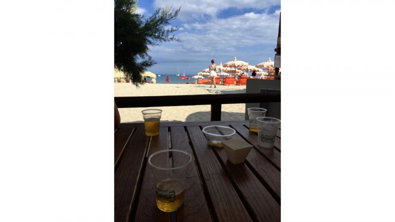
a beer by the sea. In the evening we take a 3-course menu a little further in the village and we can take it again.
Hotel Anna, Spiaggia di Fetovaia, Livorno, Italië
via del canaletto 215/c, Loc. Fetovaia, 57034 Fetovaia LI, Italië
42° 44' 4.6" N 10° 8' 56.4" E
42.7346100 10.1490040
• Head east on Via del Canaletto. Go for 227 m.
• Turn slightly left onto Via Fetovaia. Go for 127 m.
• Turn right onto Strada Provinciale Anello Occidentale (SP25). Go for 8.1 km.
• Pass 2 roundabouts and continue on Strada Provinciale Anello Occidentale (SP25). Go for 639 m.
• Turn left onto Via Roma (SP25). Go for 68 m.
• Turn right onto Via per Portoferraio (SP25). Go for 1.1 km.
• Take the 2nd exit from roundabout onto Via di Favale. Go for 320 m.
• Continue on Via dell'Acquedotto. Go for 973 m.
• Turn right onto Strada Provinciale Anello Occidentale (SP25). Go for 2.8 km.
• Turn right onto Strada Provinciale Bivio Boni Procchio (SP24). Go for 8.0 km.
• Take the 2nd exit from roundabout onto Strada Provinciale Portoferraio Bivio Boni (SP24). Go for 828 m.
• Pass 2 roundabouts and continue on Viale T. Tesei (SP24). Go for 976 m.
• Take the 1st exit from roundabout onto Viale T. Tesei (SP24). Go for 199 m.
• Turn right onto Banchina Capitano Vezio Dini (SP24). Go for 57 m.
• Take the Piombino-Portoferraio Ferry. Stay on for 26.9 km.
• Head southwest. Go for 95 m.
• Turn right onto Piazzale Premuda. Go for 131 m.
• Continue on Via Portovecchio. Go for 283 m.
• Take the 3rd exit from roundabout onto Via Portovecchio. Go for 887 m.
• Take the 1st exit from roundabout onto Via Portovecchio. Go for 125 m.
• Take the 1st exit from roundabout onto Via Felice Cavallotti. Go for 182 m.
• Continue on Viale della Resistenza. Go for 323 m.
• Turn right onto Viale dell'Unità d'Italia. Go for 850 m.
• Pass 2 roundabouts and continue on Viale dell'Unità d'Italia. Go for 1.3 km.
• Continue on Strada Provinciale della Principessa (SP23). Go for 165 m.
• Take the 1st exit from roundabout onto Località Gagno (SP23). Go for 806 m.
• Take the 2nd exit from roundabout onto Località Gagno (SP23). Go for 566 m.
• Continue toward Località Asca/SP23. Go for 37 m.
• Take the 1st exit from roundabout onto Località Asca (SP23). Go for 593 m.
• Keep right onto Strada Provinciale Fiorentina-Montegemoli (SP23bis) toward Venturina/S.G.C. Roma-Livorno. Go for 1.6 km.
• Turn left and take ramp onto Strada Statale della Val di Cornia (SS398) toward Venturina/Livorno/SS1/Roma. Go for 6.5 km.
• Take ramp onto Strada Statale Aurelia (SS1) toward Livorno. Go for 40.1 km.
• Continue on A12 (Autostrada Azzurra). Go for 31.7 km.
• Take the exit toward Collesalvetti/Firenze onto Strada di Grande Comunicazione Fi-Pi-Li. Go for 31.2 km.
• Take ramp toward S. Croce sull'Arno. Go for 229 m.
• Take the 1st exit from roundabout onto Viale Leonardo da Vinci (SP44) toward Ponte a Egola/San Miniato/S. Gimignano. Go for 228 m.
• Take the 3rd exit from roundabout onto Via Pruneta. Go for 1.4 km.
• Take the 2nd exit from roundabout onto Via Corrado Pannocchia (SS67). Go for 1.4 km.
• Turn right onto Via Catena. Go for 1.9 km.
• Turn left onto Piazza L. Benvenuti. Go for 109 m.
• Continue on Via delle Casine. Go for 503 m.
• Arrive at Via delle Casine. Your destination is on the right.
☍
174,7 km
(3 hrs. 7 min.)
Day
Reisverslag Elba
After a delicious breakfast, we first go to the beach. What is a trip to Elba without sunbathing, right? Gerard does not feel like it and stays behind on the terrace to read a book.
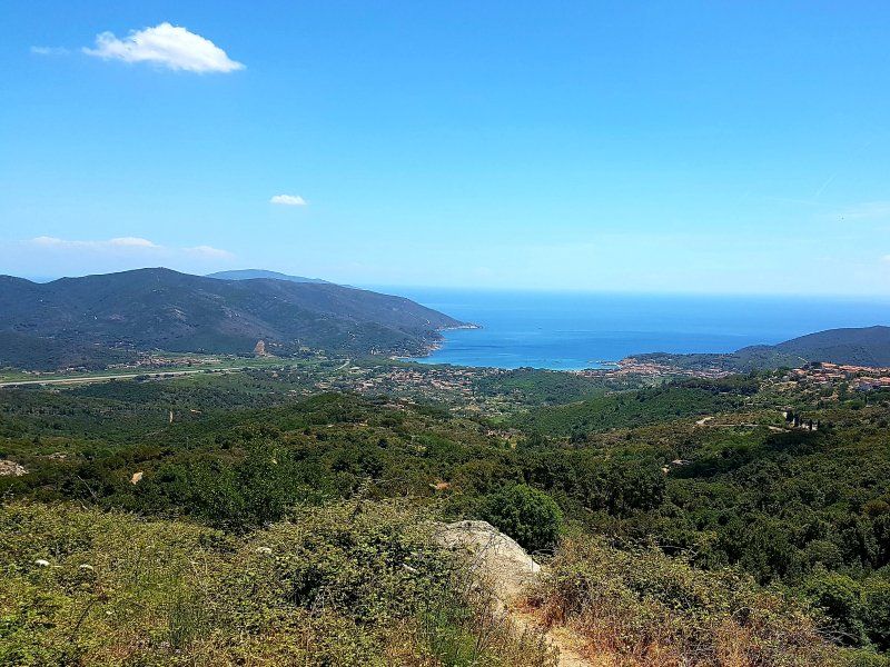
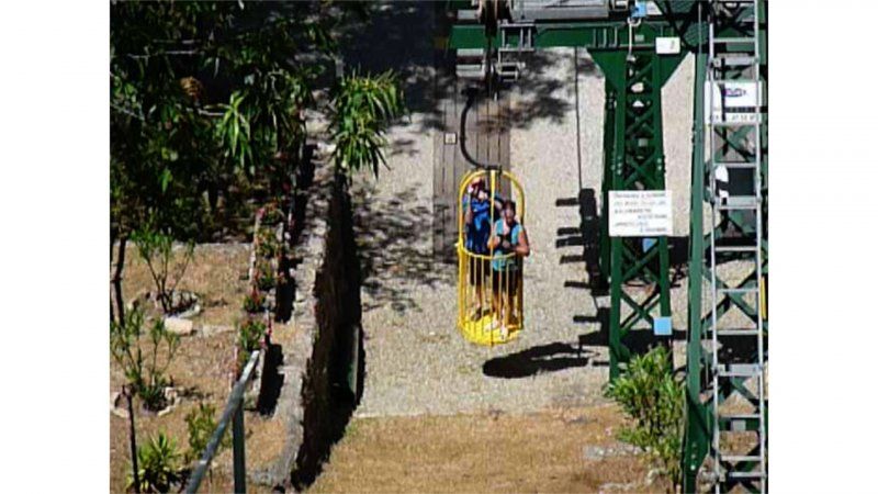
We say goodbye to Hotel Anna. We drive via the north side of the island to Monte Capanne. The cable car opens after lunch and it is an adventure !! Definitely do it if you are in the area.
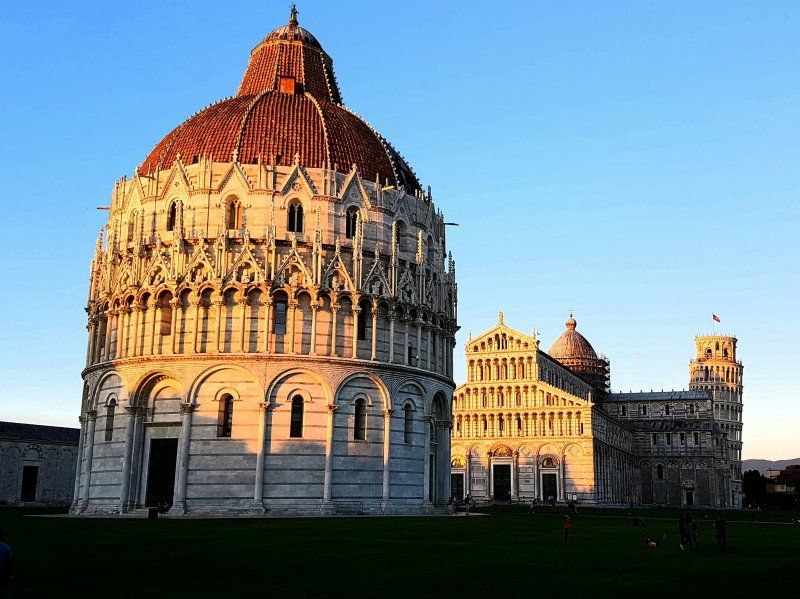
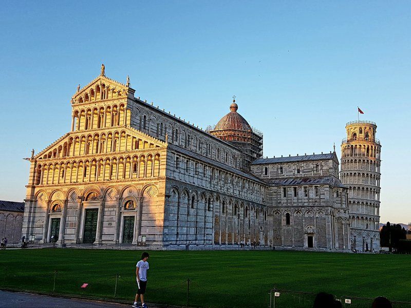
We arrive in time for the boat and after a successful crossing we arrive back at the campsite in Pisa. And what do you do when you are in Italy: you eat a pizza. Then in the twilight walk to the leaning tower.
Camping Village Torre Pendente Via delle Casine, San Miniato, Pisa, Italië
Via delle Casine, 56028 San Miniato PI, Italië
43° 41' 3.5" N 10° 50' 13.7" E
43.6842949 10.8371358
• Head south on Via delle Casine. Go for 503 m.
• Continue on Piazza L. Benvenuti. Go for 109 m.
• Turn right onto Via Catena. Go for 1.9 km.
• Turn right onto Via Tosco Romagnola Est (SS67). Go for 917 m.
• Take the 3rd exit from roundabout onto Via dei Mille. Go for 176 m.
• Continue toward Via Sanminiatese. Go for 33 m.
• Take the 2nd exit from roundabout onto Via Sanminiatese. Go for 387 m.
• Take left ramp onto Strada di Grande Comunicazione Fi-Pi-Li toward Firenze. Go for 32.8 km.
• Take ramp onto A1 (Autostrada del Sole) toward E35/Bologna-Roma/E74/Pisa Nord/A11/E80/Genova-Livorno/A12/Roma. Go for 99.8 km.
• Take the exit toward Valdichiana/Bettolle-Sinalunga/Bettolle/Pienza/Montepulciano/Ospedale Nottola/Torrita di Siena. Go for 419 m.
• Take the 2nd exit from roundabout onto Raccordo Perugia A1 (RA6) toward Ospedale Nottola/Bettolle/Perugia. Go for 59.3 km.
• Take left ramp onto Strada Statale Tiberina (SS3bis) toward Cesena. Go for 3.8 km.
• Take ramp onto Strada Statale Centrale Umbra (SS75) toward Assisi/Foligno/Spoleto/Aeroporto. Go for 3.8 km.
• Take ramp onto Via Giulio Caldarelli toward Ospedalicchio Sud/Ospedalicchio/Perugia/Aeroporto. Go for 418 m.
• Continue on Strada Comunale di Serre. Go for 511 m.
• Take the 1st exit from roundabout onto Strada Regionale di Assisi (SR147) toward Bastia/Assisi. Go for 2.4 km.
• Pass 2 roundabouts and continue on Strada Regionale di Assisi (SR147). Go for 2.5 km.
• Turn right. Go for 67 m.
• Turn right. Go for 81 m.
• Arrive at your destination on the left.
☍
209,9 km
(2 hrs. 4 min.)
Day
Reisverslag Cinque Terre
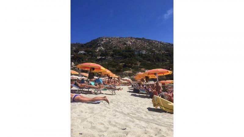
Today to the Cinque Terre. We embark in la Spezia. The boat sails from place to place and you can get on and off along the way. How hot it was!!! But what an experience. It's beautiful. You can also take the train from la Spezia: it stops in every village. Don't forget to put a date stamp on your ticket. This prevents a fine during inspection.
Here's an article from reisroute.nl about the cinque terre:
The name 'Cinque Terre' literally translates as 'five countries'. That name of course refers to the five villages that together form the 'Cinque Terre'. Since 1997, all five villages are on the UNESCO World Heritage List and together they are part of a national park, which also includes the hiking trails, the interior and part of the sea. Cinque Terre is located on the beautiful coast in Liguria in Italy. The 5 Cinque Terre villages are connected by hiking trails that cross the beautiful nature of the Riviera of Flowers. From north to south we find the villages as follows;
Monterosso al Mare
Monterosso al Mare, or simply Monterosso, is the largest and oldest village of the Cinque Terre. It was first documented in 1056. The village consists of 2 parts with the old center and the new one on the one hand and the more touristic part of Fegina on the other hand, which was developed from the 1950s. We also recommend taking the time to stroll through the old center and discover the squares, streets and shops. This place is ideal for a bite to eat or an original souvenir!
Monterosso is the only village of the Cinque Terre with a beach and the village is also known for the many lemon trees that can be found around the village. So definitely rent a beach bed here for a few hours and relax to the max! You have both a beach on the side of the old city center and in the new part, where the beach is a bit larger. In the village you can find the remains of the castle Palazzo del Podestà (the 14th century church of John the Baptist), the old monastery and the castello dei Fieschi.
In addition, you will also find the Gigante, the giant of Monterosso, namely a stone statue of Neptune that was made by Arrigo Minerbi at the beginning of the 20th century. The statue was damaged by bombs in the Second World War and by heavy waves in the following years, but that does not make it any less impressive.
Vernazza
Vernazza is considered the most charming village of the Cinque Terre. This village was first documented in 1080 and many remains of the medieval fortresses can still be found in the village. Some people think this village is the most beautiful of the five, because it is so cozy and has a lot of charm. For example, there is a very nice bay, a small church, beautiful houses in all colors of the rainbow, old boats and much more. You immediately find yourself in an old fishing village and the atmosphere is fantastic.
The church of Santa Margherita di Antiochia from 1318 and the Doria castle from the 15th century, which protected against the pirates, are the main attractions in the village. In addition, the remains of an amphitheater can be found in the village and Vernazza contains a large harbor. Vernazza was therefore the maritime base from which boats entered the Mediterranean to protect the country against pirates. One of our highlights in Vernazza is the beautiful view, but for this you have to brave a steep climb. Follow the signs for the hiking trail to Monterroso and then after a steep (but short) climb you will reach a viewpoint. Love at first sight!
Corniglia
Corniglia dates back to Roman times when the area was the land of the Cornelia family. After this it was for a long time the land of the Counts of Lavagna, after which it was finally bought in 1276 by the Republic of Genoa. Corniglia is the only village of the Cinque Terre that is not directly connected to the sea and the houses of the village are located on a rock at an altitude of 100 meters above sea level. This makes Corniglia more of an agricultural village than a fishing village like the other 4 villages. The village can only be reached via a staircase with 382 steps. In the village it is recommended to visit the church of Saint Peter, built in the 14th century and very beautifully decorated, the facade is made entirely of Carrara marble.
Corniglia is generally less busy than the other villages, which can be pleasant. When you stroll through the narrow streets towards the church, be sure to take a look behind the church. From there you have a beautiful view of the area around Corniglia. Furthermore, this is also the perfect place to have a nice drink or one of the many cozy terraces.
Manarola
Manarola is known for its wine, but it also contains a number of special buildings, such as the mill wheel that gave the village its name and the church of San Lorenzo from 1338. There is also an old white cement pyramid in the village that used to be mark was used by navigators. Manarola is a very photogenic place. When you look up Cinque Terre, you will often see this colored village pop up. The best place to take the most beautiful pictures of Manarola is at the Manarola Scenic Viewpoint (see location on the map). This viewpoint is very popular and therefore also frequented by tourists, but it remains very beautiful, so we thought it was worth the crowds. Fun fact: during the Christmas season you will find a nativity scene with 15,000 lights in Manarola.
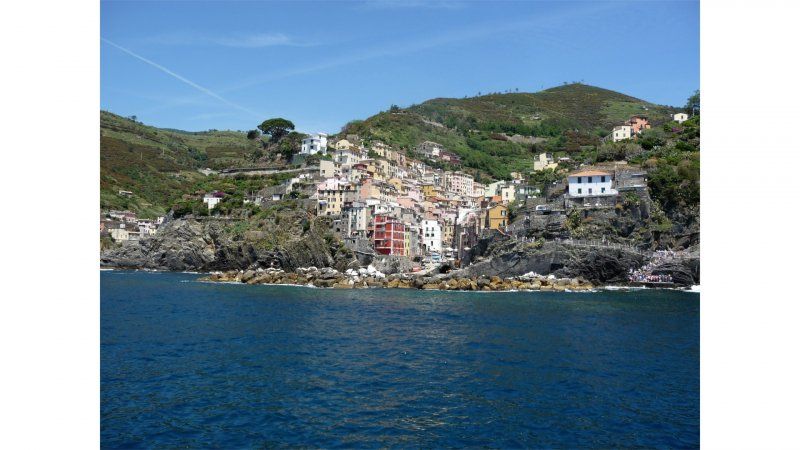
Riomaggiore
Riomaggiore is the capital of the Liguria region and this is the southernmost and this village really still looks like a fishing village. What's more, it really smells like fish! This place is the most pristine of the five. You can explore it walking through the steep paths, the dark alleys and be sure to pass by the small bay with fishing boats. Here you will find more traditional life and less tourist development. Do you also want to enjoy a sunset or a beautiful view here? Go into the bay looking for the viewpoint that is a bit higher here.
Riomaggiore was first documented in 1251, when it became part of the Republic of Genova. The buildings in the village are high-rise and contain several floors and are colored in shades of pink, red and ochre. In the village there is an old stone castle which was first mentioned in documents from the 6th century, in which the building was already called 'old'. In addition, the church of John the Baptist from 1340 with a wooden statue of Mary is also a major attraction.
The hiking trails
Between the 5 villages there are several hiking trails that for years were the only roads between the villages and the nearby villages and towns. There are 3 main paths that run between the different villages, and also a lot of smaller paths. You can find the route map online on the website.
The Sentiero Alto path
The Sentiero Alto path is an old donkey road that dates back to Roman times. The path starts in Levanto and runs through a mountain ridge to Porto Venere. The path is 40 kilometers long, straight and without debris, making it walkable by everyone. The entire route takes at least 10 hours, but it is recommended to divide the path into parts.
The Sentiero Azzuro path
The Sentiero Azzuro path is 12 kilometers long and runs along the 5 villages along the coast. You will also pass several olive groves and vineyards and the Via dell'Amore is also part of this path. The height difference on this route is 600 meters, but this is spread over 10 kilometers and it is therefore very easy to walk for every walker. The route takes about 4 hours.
Via dei Santuari
The third major path is the Via dei Santuari which goes through the churches located just outside the villages. The path goes through an easy route and it is easily accessible for every walker.
We did it relaxed and after a day on the water we are rosy and happy to be back at the campsite.
Day
Reisverslag reisdag
Today we drive to Assisi. We have been there before and were deeply impressed by the town and the area. And it is certainly not a disappointment for the second time.
Along the way we drive smoothly, but we have the idea that the roads are getting worse as we travel south.
The campsite is fine. We meet a young couple there, who are traveling to Greece with 2 children in a camper. Nice chat.
Camping Village Assisi, Via Campiglione, Assisi, Perugia, Italië
Via Campiglione, 110, 06081 Assisi PG, Italië
43° 4' 33.4" N 12° 34' 27.4" E
43.0759390 12.5742890
• Head west. Go for 81 m.
• Turn left toward Strada Regionale di Assisi/SR147. Go for 67 m.
• Turn left onto Strada Regionale di Assisi (SR147). Go for 1.9 km.
• Pass 2 roundabouts and continue on Viale del Popolo (SR147). Go for 2.9 km.
• Take the 3rd exit from roundabout onto Strada Comunale di Serre toward Foligno-Perugia/Firenze-Roma/A1. Go for 448 m.
• Take ramp onto Strada Statale Centrale Umbra (SS75) toward Perugia/Aeroporto. Go for 3.6 km.
• Take left ramp onto Strada Statale Tiberina (SS3bis) toward Perugia/Firenze/A1/Roma/Lago/Lago Trasimeno. Go for 72.8 km.
• Take ramp onto Raccordo Terni-Orte (SS675) toward Firenze-Roma/A1/Roma/A1/Orte/Autostrada/A1. Go for 20.2 km.
• Take ramp onto E45 toward Roma/A1/Firenze. Go for 1.7 km.
• Take the 3rd exit from roundabout onto A1 (Autostrada del Sole) toward Roma. Go for 39.6 km.
• Take the exit toward Roma Centro/Grande Raccordo Anulare/Aeroporti/Civitavecchia/A12/E80/Roma Nord/Rieti onto A1dir. Go for 22.8 km.
• Take the exit toward Roma Centro-Salario/Salaria/SS4/Flaminia/SS3/Cassia/SS2/Aeroporto Fiumicino/E80/Porto Civitavecchia/A12 onto A90 (Grande Raccordo Anulare). Go for 20.6 km.
• Take exit 1 toward Roma Centro-Aurelio/Città del Vaticano onto Via Aurelia. Go for 3.3 km.
• Take ramp toward Ospedale/Grande Raccordo Anulare/Civitavecchia. Go for 57 m.
• Take the 2nd exit from roundabout onto Via Aurelia toward Ospedale/Grande Raccordo Anulare/Civitavecchia. Go for 126 m.
• Turn slightly right toward Via Sofia. Go for 77 m.
• Continue on Via Sofia. Go for 169 m.
• Turn right onto Via di Villa Troili. Go for 128 m.
• Turn left onto Via Londra. Go for 59 m.
• Arrive at Via Londra.
☍
190,5 km
(1 hrs. 50 min.)
Day
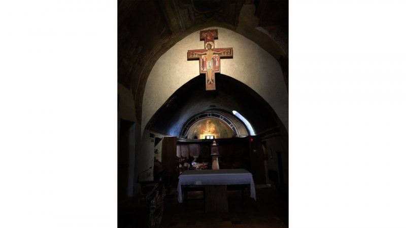
Vandaag Assisi
We visit Assisi: From the parking lot we take the escalator up, towards Porta Nuova, one of the city gates of Assisi. We walk on the Via Borgo Arentino. It is very hot and we first score a fan. Every now and then we catch a glimpse of the Basilica di Santa Chiara, where we still go. We arrive at Piazza Santa Chiara and we are short of eyes. First of all, there is an octagonal fountain, the Fontana di Santa Chiara. It is the newest fountain in Assisi, although this fountain was already completed in 1872. The square also offers a beautiful view of the castle, the Rocca Maggiore, which towers high above the city. On the other side of the square you look out over the Valle Umbra. With clear weather you can even see the city of Perugia. One of the places that attracts many pilgrims is Santa Chiara. We also visit the basilica, which is dedicated to Saint Clare of Assisi, one of the followers of Saint Francis of Assisi. The church is the most important religious site in Assisi after the Basilica di San Francesco. The Santa Chiara was built between 1257 and 1265. On October 3, 1260, the remains of the saint were also transferred to the basilica. Via the stairs on the right side we descend to the crypt where the remains of Santa Chiara are kept. You can also admire a number of relics of Saint Clare and Saint Francis, such as clothes and locks of hair.
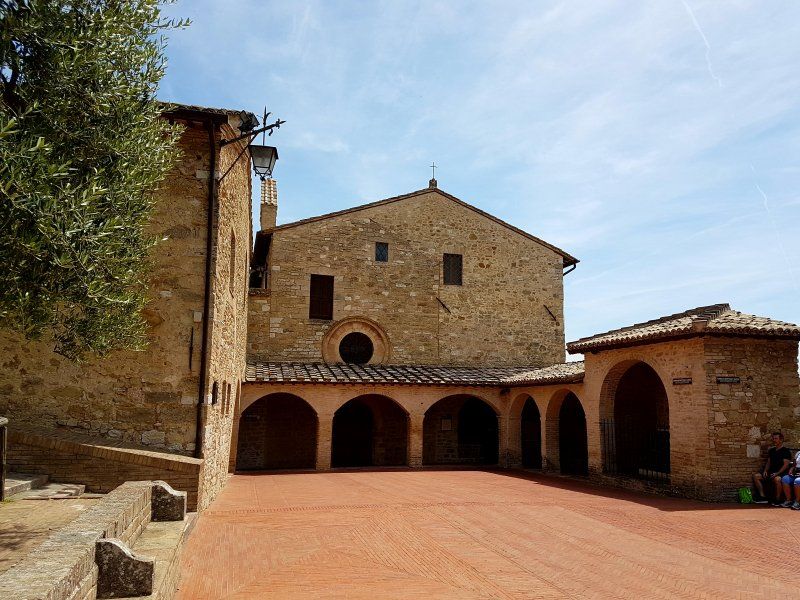
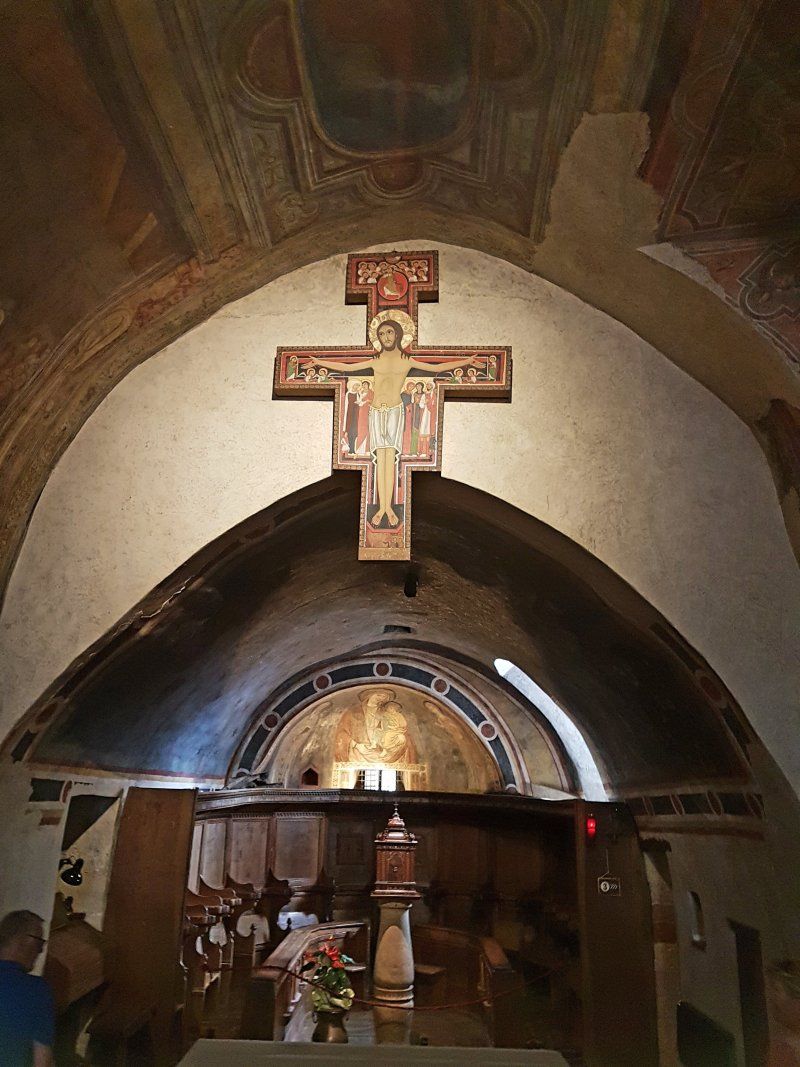
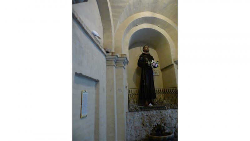
We walk through the vineyards to San Damiano. If you're looking for beautiful art and grand architecture, you won't find much to your liking here, but the spiritual significance of this location is immense. In 1205, Francis of Assisi was walking in the valley and stopped at the small church of San Damiano, about a kilometer outside Assisi's city walls. The church, probably built about a century earlier, was in a very bad state. In fact, she could collapse at any moment. When Francis knelt to pray, he suddenly heard the crucifix in the church speaking to him. Christ on the cross told the future saint that his house was being destroyed and Francis had to rebuild it. This event was later immortalized by the great artist Giotto. At first, Francis took the assignment literally: he thought he had to restore this particular church, but Christ, of course, meant the Church in general. Between the summer of 1206 and early 1208, Francis focused not only on the restoration of the church of San Damiano, but also on the rural church of San Pietro della Spina and the Porziuncola chapel, which is now part of the huge Basilica of Santa Maria degli Angeli. At the same time, Francis had found a new spiritual mission in caring for lepers. That was special, because in thirteenth-century Italy these people were seen as dangerous pariahs by almost everyone. Although many shunned him, Francis's activities also ensured that he gained admirers. By the end of 1208 he had about a dozen followers. In 1209 Pope Innocent III (1198-1216) gave his approval to the growing community of the fratres minores or Friars Minor. Adoption of the Franciscan Order and the Franciscan Rule would not occur until 1223. Anno 1209, the Franciscans were no more than a not-so-joyful brotherhood that had devoted themselves to radical poverty, manual labor and traveling barefoot to preach. In 1212, Francis delivered a sermon at San Rufino Cathedral. Among the audience was a young woman named Chiara Offreduccio (c. 1193/94-1253). We now know her as Clara of Assisi or Santa Chiara. Chiara was deeply impressed by Francis' sermon. She lived close to the cathedral and came from a very wealthy family, but she refused to marry, coveting only a life of prayer and devotion to God. Soon, Francis became her spiritual teacher. It was of course inconceivable that a woman would join the Friars Minor. The community of the Franciscans was only open to men. After cutting her hair and dressing her in a simple tunic, Francis took Chiara to a community of Benedictine nuns who had a convent in Bastia Umbra, just west of Assisi. However, Chiara's uncles tried to kidnap her there and she had to cling to the altar to avoid being taken away. Chiara moved to another convent, but history repeated itself there. Then, with the help and permission of Bishop Guido of Assisi, Francis decided to send Chiara to San Damiano and found a monastery there. Chiara and up to 50 nuns would live there in peace and harmony for more than 40 years. They earned some money selling altar cloths, grew vegetables in the vegetable garden, and spent most of the day praying, singing, and working. In 1253, Pope Innocent IV (1243-1254) approved the Rule of the Second Order of Saint Francis. We now know this Order as the Poor Clares. Chiara passed away the next day. In 1255 she was canonized by Pope Alexander IV (1254-1261). After the foundation of the Convent of the Poor Women in 1212, Francis returned several times to the church and convent of San Damiano. Presumably in 1222 he preached here and celebrated Ash Wednesday with Chiara and the other nuns. He was forty years old at the time and was in poor health due to malaria and eye infections. Although he always recovered, the afflictions returned, and in 1225 he was housed in a small hut that was part of the complex of San Damiano. Suffering from excruciating pains, Francis began here to write his greatest contribution to the Christian faith and Italian literature, a song known as the Laudes Creaturarum or – in Dutch – the Canticle of the Sun. The song is written in the Umbrian dialect and praises God's Creation. Francis himself was never able to set the song to music. Carl Orff (1895-1982) did. On October 3, 1226, Francis died in his cell close to the Porziuncola chapel. The next day his body was transferred to the church of San Damiano where it was venerated by Chiara and her Poor Women. Chiara herself died almost 27 years later, in a room in the convent that you can still visit. Both Francis and Chiara were canonized just two years after their deaths, in 1228 and 1255 respectively. Beautiful new but rather un-Franciscan basilicas were built for them in Assisi, where their remains could be kept. Not long after Chiara's death, the Poor Women left the convent of San Damiano. The new Basilica di Santa Chiara was built between 1257 and 1265 and Chiara's body was buried there. The nuns moved to the convent next door, taking with them the famous crucifix that had spoken to Francis. So tourists and pilgrims who want to see the original should go to the church of Santa Chiara. The church of San Damiano has only one copy. It was already mentioned above that the church and the monastery of San Damiano cannot boast of significant art or architecture. Unlike the great basilicas in Assisi itself, the complex was never embellished. The church exterior is extremely simple and the rose window seems to be in the wrong place (it is in the middle, but the church is only half the width of the facade). External decorations are completely absent. Once inside the church, visitors quickly realize how small the building is. The church is single-aisled and sparsely decorated. In addition to the aforementioned replica of the crucifix, we can take a look at an apse fresco of a Madonna and Child with Saint Rufinus and Saint Damianus. Rufinus is the patron saint of Assisi. He lived in the third century and is traditionally considered the first bishop of the city. He is also said to have converted the population of Assisi to Christianity. Damianus is of course one of the twin brothers from Arabia, Cosmas and Damianus (see Rome: Santi Cosma and Damiano). For some reason the church is only dedicated to him and not also to his brother Cosmas. The most interesting fresco is in the back of the church. It shows us Francis praying in the San Damiano (left) and Francis being chased with a club by his father (right). Above the father we see the walled city of Assisi. The fresco was painted in the fourteenth century. There is a niche in the wall. This is where Francis is said to have thrown the money he had collected for the repair of the San Damiano. Elsewhere in the complex we find a fresco of Santa Chiara and her nuns by an unknown master and a fresco of the Crucifixion (ca. 1482) by Pier Antonio Mezzastris (ca. 1430-1506). The walls of the monastery were frescoed in 1507 by Eusebio da San Giorgio. Here is also the entrance to the refectory. Visitors were not allowed to enter it when I visited the complex in August 2017, but fortunately it was possible to peer in through the open door. The refectory is still largely in its original, thirteenth-century state. On the wall we see a painting (which is certainly younger than the refectory itself) depicting a miracle that allegedly took place when Pope Gregory IX (1227-1241) visited the complex. After Chiara blessed the pieces of bread, crosses suddenly appeared on them. I certainly enjoyed my visit to the San Damiano. The complex is a peaceful spot in the valley that has fortunately retained its typical Franciscan simplicity. Please note that the walk to the San Damiano is easy, but that you have to go uphill on the way back! After visiting this special place, we continue our way through Assisi. Through the old Roman gate we walk towards the Piazza del Comune. Along the way we fully enjoy the many beautiful vistas and beautiful medieval facades with lots of flowers. Just before the Piazza del Comune we turn left at a small gate. We follow the Scaletta dello Spirito Santo down. At the bottom left of the stairs you will find the place where Franciscus is believed to have been born. The Oratorio di San Francesco is said to have been built in the former stable of Franciscus parents.
Franciscus parental home has since been converted into a church, the Chiesa Nuova, but the original wooden door is still visible. In front of the church, on the Piazza Chiesa Nuova, is a beautiful bronze statue of Francis' parents. We climb a bit higher into the city and now we really set course for the Piazza del Comune. This large central square, surrounded by many monuments, is the center of Assisi. The most eye-catching is without a doubt the Tempio di Minerva. This Roman temple has been preserved because it has become a Christian church, just like the Pantheon in Rome. On the square you will also find the Fontana dei Tre Leoni ('fountain of the three lions') and several cozy bars where you can enjoy a delicious caffè or aperitivo. The last time we stayed there was in a hotel just around the corner: hotel la Fortezza.
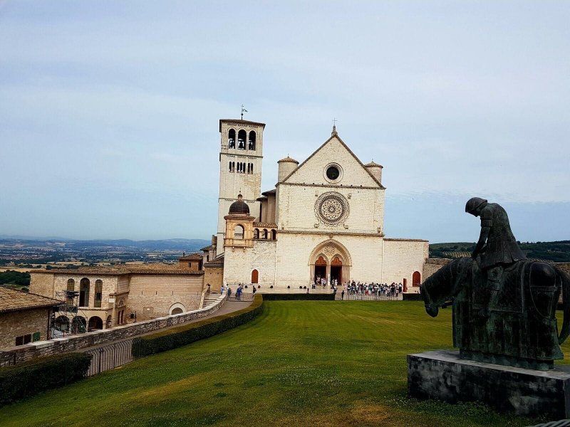
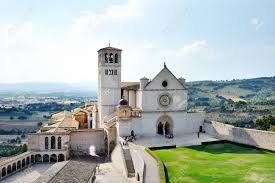
We leave the Piazza del Comune to visit the Basilica di San Francesco. While walking on the Via Portica, the Via Arnaldo Fortini and the Via San Francesco, we come across beautiful vistas and the beautiful Fonte Oliviera. At the end of the Via San Francesco, an amazing view of one of the most beautiful basilicas in Italy unfolds: the Basilica di San Francesco. Before visiting the basilica, we take a moment to photograph the church.
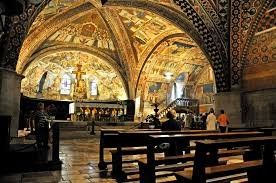
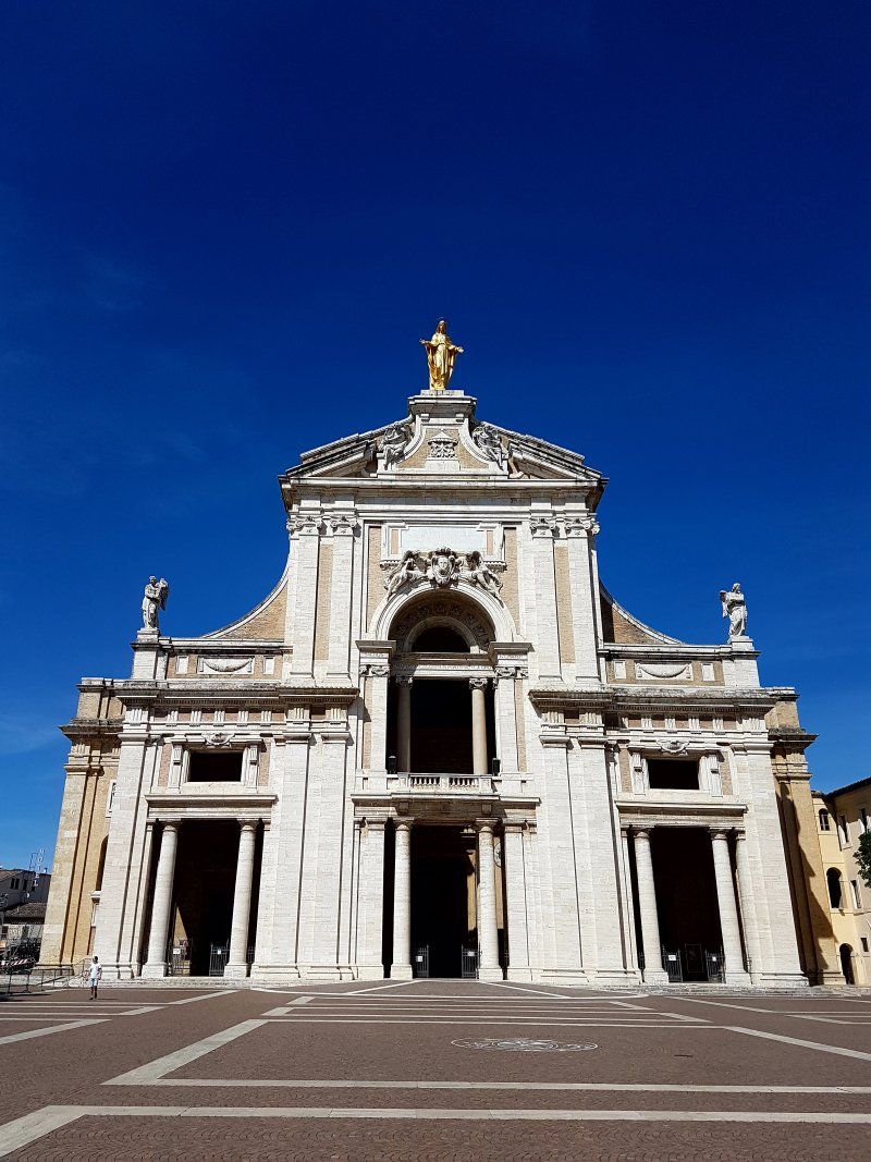
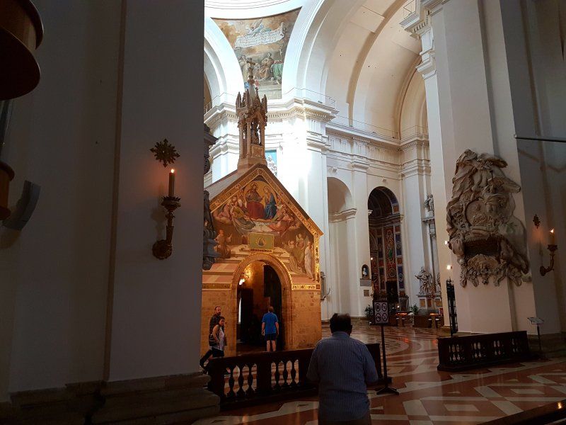
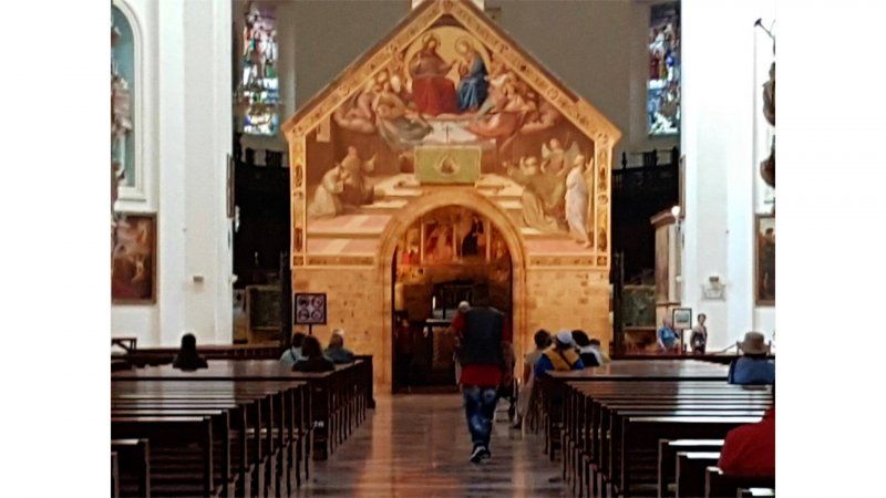
The crown jewel of the Franciscan buildings recognized as a UNESCO World Heritage Site in Assisi, the Basilica di San Francesco deeply moves believers and art lovers alike. The immense and ambitiously designed basilica can be seen from miles away and offers you a beautiful view of the valleys around the city of Assisi. You can easily spend an afternoon exploring the churches, gardens, piazzas and crypt that houses the intriguing tomb of Saint Francis. In 1997, disaster struck Assisi in the form of two devastating earthquakes, which caused extensive damage to the two original churches and other parts of the basilica. It took no less than two years before the building was completely restored. The basilica is divided into a lower church, the Basilica Inferiore, built immediately after the canonization of Francis in 1228, and a higher church, the Basilica Superiore, built between 1230 and 1253 . Romanesque and Gothic influences come together in the architecture. A stroll through the squares and gardens near the basilica will give you a glimpse of this impressive display of architectural styles. The simple façade of the Basilica Superiore does not suggest that such a beautifully designed interior is hidden behind it. Here hangs one of Italy's most famous works of art, a series of frescoes depicting the life of St. Francis. A staircase leads down from the outside of the upper church to the dimly lit Basilica Inferiore. See frescoes by famous Florentine painters such as Cimabue that depict parallels between the lives of Christ and Francis. In the many richly decorated side chapels, you can trace the different movements that have dominated Italian art over the centuries. Then, descend to the crypt where you will find the tomb of Saint Francis. The tomb was built in the 19th century after the relics of Francis were discovered. Initially, a marble tomb in neoclassical style was chosen. This was adapted again in the 20th century to a Neo-Romanesque construction of stone. Sources: ciauatutti.nlcorvinus.nlexpedia.nl
Santa Maria degli Angeli
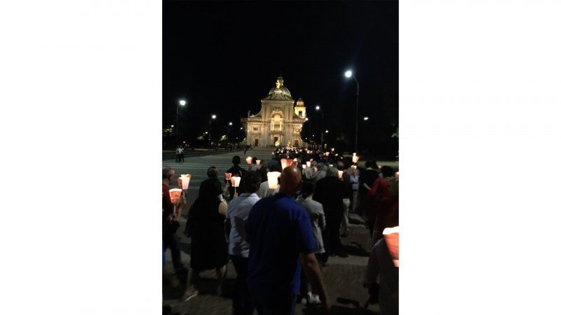
Just outside Assisi you will find the Santa Maria degli Angeli, a church that contains a smaller gem: La Porziuncola, the chapel where Saint Francis often came to pray. That is today's goal. We park the car at the rear of the church, a bit in the shade. When Francis found the church in a very neglected state in the early thirteenth century, he decided to restore it himself. In 1210, the abbot of the Abbey of Benedict of Subasio gave him the chapel as a reward for his restoration work. Francis decided to make this place, on a piece of land known as Portiuncula ('little piece of land'), his home and to use it for prayer with his confreres. A small community grew up around it. On August 2, 1216, the chapel was officially consecrated by the bishop of Assisi. After that, the number of friars gathered around Francis quickly grew. On May 30, 1221, the first meeting of a movement that would grow into the Franciscan order was held. Five years later, Francis breathed his last here, after which La Porziuncola became an increasingly popular place of pilgrimage. In order to offer all those believers a place to pray, construction of the Santa Maria degli Angeli started in 1569, a large church that was built over the smaller Porziuncola chapel. In 1679 this church was completed and more pilgrims flocked to it. In 1909, the church was declared a basilica by Pope Pius X, officially making La Porziuncola a papal chapel. Inside the basilica, admire a majolica statue of Francis created by Tuscan artist Andrea della Robbia and colorful frescoes in the Cappella del Roseto. In addition, the place where Francis died. The biggest pearl, however, remains La Porziuncola. The painting on the façade dates from 1829 and is by the German painter Friedrich Overbeck. On the right side of the chapel you can still see some frescoes from the fifteenth century, with a Madonna and Child standing between Saints Francis and Bernardinus. photo: Umbria Tourism Perugino painted the Crucifixion on the back of the chapel, but unfortunately a large part of this scene has been lost. Inside the chapel, your attention is immediately drawn to the colorful altarpiece by Ilario da Viterbo, a priest who tells the story of the forgiveness of Assisi in five works source: ciaotutti.nl We read somewhere that a procession is held in the evening. We decide to go there. We are there in plenty of time, but nothing happens at all. We think that we have come for nothing, that we have misunderstood. But then more and more people arrive, candles are handed out and eventually we join in the procession.
Day
Reisdag
We drive to Rome. What is it hot. The hottest summer in ages. When we arrive at the campsite we get a spot at the top. That's wonderful: there is some wind. There is a lamp post at the site. After 1 night the men decide to put a bag on it because it is very light in the tent.
The campsite is really fine: well maintained and clean.
Roma Camping in Town, Via Aurelia, Rome, Italië
Via Aurelia, 831, 00165 Roma RM, Italië
41° 53' 10.7" N 12° 24' 24.4" E
41.8862940 12.4067688
• Head toward Via di Villa Troili on Via Londra. Go for 111 m.
• Turn right onto Via di Villa Troili. Go for 43 m.
• Turn left onto Via di Villa Troili. Go for 18 m.
• Turn left onto Via di Villa Troili. Go for 253 m.
• Turn slightly left onto Via Aurelia. Go for 55 m.
• Turn right onto Via Vincenzo Arangio Ruiz. Go for 63 m.
• Turn left and take ramp onto Via Aurelia toward Civitavecchia/Grande Raccordo Anulare. Go for 2.2 km.
• Take ramp onto A90 (Grande Raccordo Anulare) toward Fiumicino/A91/E45/Napoli/A1. Go for 28.8 km.
• Take exit 19 toward E45/Napoli/A1 onto A1dir. Go for 18.6 km.
• Take the left exit toward E45/Napoli onto A1 (Autostrada del Sole). Go for 184 km.
• Continue on E45 toward Salerno-Reggio C./A3. Go for 1.0 km.
• Continue on A3 (Autostrada Napoli-Salerno). Go for 17.6 km.
• Take the exit toward Pompei Scavi. Go for 229 m.
• Turn left onto Via Plinio toward Pompei. Go for 505 m.
• Arrive at Via Plinio. Your destination is on the right.
☍
253,3 km
(2 hrs. 10 min.)
Day
Rome
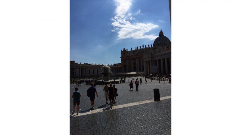
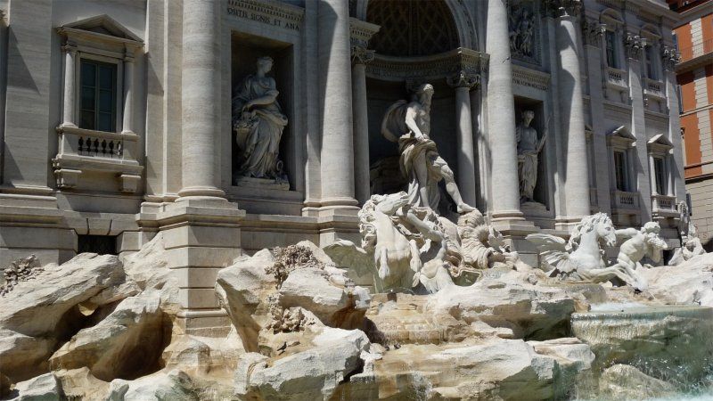
Today we are going to visit Rome. We take the bus to the center, at least that was the intention. After some detective work we pass the walls of the Vatican Museum and arrive at St Peter's Square. It is very hot again. The square is bathed in sun and early on it is more than 36 degrees. We find some coolness in the shadow of the Obelisk. So funny: there are all chairs behind each other. There is a long queue to visit St. Peter's in the full sun. We decide not to do that and walk through. First stop: the Pantheon. We want to go in there, but my shoulders are uncovered, so that's not allowed. I am also not allowed to sit on the edge of a column. Then just a scarf and still inside. The Piazza Novaro and the Trevi Fountain soon follow. With the hop on-hop off bus we get to the Coloseum. Here too the line is longer than long and we continue. But first buy a parasol. How much you want to see the sun on your holiday, this is really great. We walk around a bit and decide to go back to the campsite: it is really too hot. We take an Uber and arrive in one piece.
Day
Dag aan het zwembad.
It is too hot to do anything and we decide not to do anything: swimming pool.
Day
Reisverslag Pompeii
We drive from Rome to Naples. The route is easy to do, but the roads are getting worse. Harry has to pay close attention and avoid holes in the road. The campsite is easy to find in Pompeii.
Arriving at the campsite, our reservation appears, not a reservation but a request. Well, there you are with 4 people. Fortunately, there is still a spot available somewhere. The caravan can be inserted exactly, the door can be opened, but then you've really had it. The tent can only stand without an outer tent. Fortunately, the weather is still beautiful. We'll take the spot anyway.
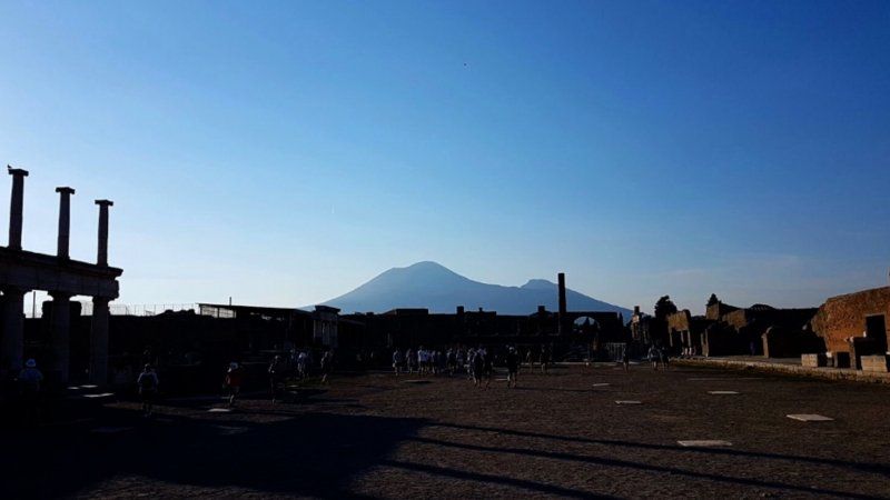
In the early evening we visit Pompeii. Beautiful with the setting sun! recommended. It is no longer so hot and certainly not busy.
Pompeii was built in 79 AD. Chr. during an eruption of the volcano Vesuvius buried by lava. The first excavations were not carried out until 1748, making it one of the best-preserved Roman cities.
During the excavations, a scientist discovered that there were hollow spaces under the thick layer of lava. They arose because the bodies of buried people had perished over the centuries. By casting plaster in these hollow spaces, the archaeologists were able to show how people and animals were surprised by the piping hot lava flow. Many hollow spaces were found especially at the main gate of Pompeii. It must have been a huge squeeze there from people trying to flee the city.
The forum, as in any Roman city, is the center of Pompeii. On the north side is the main temple, the Jupiter Temple, flanked by two arches of honor. You can also see the remains of a pulpit, the suggestus. In the southwest of Pompeii, against the city wall, is the amphitheater that was used for gladiatorial and wild animal fighting. In 59 n. Chr. this theater was the scene of serious riots between residents of Pompeii and neighboring Nuceria. These riots are depicted in a fresco transferred from Pompeii to the National Archaeological Museum in Naples.
Walking through the streets of Pompeii you imagine yourself back in time. In several places you see stepping stones to cross the street. The carts were able to drive exactly between these stones. You can also see very clearly which craft was carried out in a particular house: grinding stones and ovens indicate a bakery, medical instruments a doctor, and iron objects an ironmonger. Of course there were also several bathhouses; the erotic scenes on the walls have been partly preserved.
Also nice are the houses that were always built around a courtyard. Not only did this provide shade, but rainwater was also collected there in the impluvium. That impluvium was often decorated with a statue, like the bronze faun in the House of the Faun. The House of the Vettii belonged to wealthy merchants. It has a beautifully restored garden with statues and fountains, and the rooms feature beautiful frescoes with mythological subjects.
What can I report about the campsite itself: This campsite is really as you expect an Italian campsite: very small places, lots of crowds and traffic. But then x 3. It is very busy; all day and night. The campsite has cottages that are rented per hour. As someone described it: the Italian man lives at home for a long time and sometimes wants to be alone with his girlfriend ....... ahum. In addition, the places that are free during the day are used as parking spaces. One of the reasons for us to leave after 1 night.
source: cityspotters.com
Camping Spartacus, Via Plinio, Pompei, Napels, Italië
Via Plinio, 127, 80045 Pompei NA, Italië
40° 44' 48.2" N 14° 29' 2.9" E
40.7467361 14.4841444
• Head west on Via Plinio. Go for 78 m.
• Turn right onto Piazza Porta Marina Inferiore toward Napoli. Go for 42 m.
• Turn left onto Svincolo Pompei toward A3. Go for 272 m.
• Take ramp onto A3 (Autostrada Napoli-Salerno). Go for 18.0 km.
• Continue on E45 toward Caserta-Roma/A1/E842/Avellino/A16/Bari/A14/Tangenziale/Aeroporto. Go for 854 m.
• Continue on A1 (Autostrada del Sole). Go for 1.4 km.
• Take the exit toward Napoli/Pomigliano/Cercola/Ottaviano/SS268 onto SS162dir. Go for 8.5 km.
• Take ramp onto A16 (Autostrada dei Due Mari) toward E55/Bari/A14/Avellino/Sa-Reggio C./A30. Go for 121 km.
• Take the exit toward Candela/Foggia/Lucera/Manfredonia/Melfi/Rionero in Vulture/Ascoli Satriano/Orta Nova/Lavello. Go for 309 m.
• Continue on Località Fontana Falco (SP95). Go for 358 m.
• Continue on Strada Provinciale Cerignola Candela. Go for 116 m.
• Take the 2nd exit from roundabout toward Cerignola. Go for 262 m.
• Continue on SP95. Go for 32.6 km.
• Take the 1st exit from roundabout onto Strada Provinciale Candela-Cerignola. Go for 408 m.
• Take the 2nd exit from roundabout onto Viale di Ponente. Go for 396 m.
• Take the 2nd exit from roundabout onto Viale di Ponente. Go for 169 m.
• Take the 1st exit from roundabout onto Viale U.S.A. Go for 775 m.
• Take the 3rd exit from roundabout onto Via Manfredonia. Go for 8.8 km.
• Pass 2 roundabouts and continue on Strada Statale Rivolese (SS545). Go for 15.9 km.
• Continue on Strada Statale delle Salline per Manfredonia Corso (SS159) toward Monte San'Angelo. Go for 4.9 km.
• Take the 2nd exit from roundabout onto SP141. Go for 3.0 km.
• Turn right. Go for 420 m.
• Arrive at your destination on the left.
☍
218,4 km
(2 hrs. 11 min.)
Day
Reisverslag
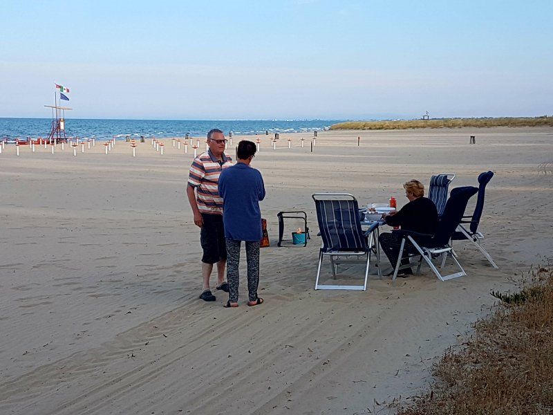
Today we drive to Manfredonia. The roads remain bad. Almost after every ride I have to put clothes back in the closets. They rattle off along the way. After some searching we find the campsite. We are on a spot near the beach, just outside the campsite. A quiet place, but a lot of mosquitoes. For the first time we really suffer from it. Especially Rina, who gets stabbed a lot. We keep our spirits up and use the mosquito net when we go for a coffee. Unfortunately we didn't take a picture of it. What's so nice about camping is that you see, smell and hear a lot: on this campsite someone is sleeping early in the evening. He snores so loud that many fellow campers get ahead of him.
Camping Lido Salpi Manfredonia, Riviera Sud - ex S.S. 159 Km 6,200, Manfredonia, Foggia, Italië
Riviera Sud - ex S.S. 159 Km 6,200, 71043 Manfredonia FG, Italië
41° 33' 19.2" N 15° 53' 34.9" E
41.5553245 15.8930200
• Head west. Go for 420 m.
• Turn right onto SP141. Go for 5.3 km.
• Turn left toward Viale Giuseppe Di Vittorio. Go for 61 m.
• Continue on SS89. Go for 887 m.
• Take ramp onto SS89 toward Foggia/Autostrada/A14. Go for 28.7 km.
• Take ramp onto A14 (Autostrada Adriatica) toward Bologna/Bari/Pescara/E55. Go for 212 km.
• Take the exit toward Roseto. Go for 555 m.
• Continue on Strada Statale della Valle del Vomano (SS150). Go for 144 m.
• Take the 3rd exit from roundabout onto Strada Statale della Valle del Vomano (SS150). Go for 181 m.
• Pass 2 roundabouts and continue on Via Salara (SS150). Go for 2.3 km.
• Turn slightly left onto Via Francia (SP19b). Go for 992 m.
• Continue on Località Piana degli Ulivi (SP19b). Go for 409 m.
• Turn right onto Località Piana degli Ulivi (SP19). Go for 90 m.
• Continue on SP19. Go for 1.4 km.
• Continue on Via Adriatica (SP19). Go for 870 m.
• Turn left onto Via Nazionale (SS16). Go for 1.1 km.
• Turn right onto Via Palermo. Go for 113 m.
• Turn left onto Viale Makarska. Go for 1.0 km.
• Arrive at Viale Makarska. Your destination is on the right.
☍
256,4 km
(2 hrs. 21 min.)
Day
Reisverslag Vieste
Today we drive via a beautiful route to Vieste. Once there, of course, first a coffee.
what a nice place:
It is a very photogenic town, thanks to its spectacular location, on rocks that reach far into the sea. The medieval center is a maze of alleys, where the smell of salty sea air and spicy tomato sauce wafts.
The houses seem stuck together, because of the many arches and staircases. In one of those alleys, between Via Cimaglia and Via Boncompagni, you come across the Chianca Amara ('bitter stone'), which seems to have been placed there just like that. However, it is a monument, in memory of the thousands of inhabitants of Vieste who were killed during the Turkish invasions in the fifteenth and sixteenth centuries.
Finally, the network of streets leads you to the cathedral, which was built on the remains of an ancient temple dedicated to the goddess Vesta. The bell tower is modeled after a cardinal's hat.
We come to a liquor store. We are stocking up on that: Limoncello and Mandarin liqueur. Wonderful to drink cold.
Pizzomunno – a petrified fisherman on the beach of Vieste
At the foot of Vieste, Pizzomunno beach shines, taking its name from the towering white limestone at the edge of the beach.
Pizzomunno was a handsome fisherman who went out to sea every day, rain or shine, to catch fresh fish. All the women were in love with him, but not only that: the mermaids also gladly surfaced to catch a glance from Pizzomunno.
However, Pizzomunno does not see them all standing – or swimming. He is madly in love with Cristalda, the most beautiful girl in Vieste, with long blonde hair that sparkles in the sun. Fortunately, the love is mutual and the two lovers are together as much as possible.
When Pizzomunno sets sail, not even the most beautiful mermaids can seduce him. In desperation, they decide to kidnap Cristalda. While the girl is waiting for her fisherman, she is swept out to sea by a huge wave.
When Pizzomunno does not see her silhouette when he returns to the port of Vieste, he is so sad that he cannot move. The pain of her loss slowly turns him into a large rock, which can still be seen motionless near the shoreline of Vieste. Only once every hundred years are the lovers briefly brought to life and can they love each other for a summer night.
source: ciaotutti
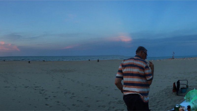
BBQ op het strand
Because there are so many mosquitoes, we have a bbq on the beach. How nice is that! The mosquitoes think so too and they go along en masse and sting at it.
Day
Strand
We are tired of traveling and decide to do nothing for a few days. It is still very warm and that takes its toll. Camping Surabaya is the next stop: fine for a few days. We are on the sea side and get a little wind. The car is also washed: it was really necessary.
Camping Village Abruzzo Surabaya, Viale Makarska, Roseto degli Abruzzi, Teramo, Italië
Great campsite. But watch out: tunnel height on the route to it is 1.50 mtr.
On the camping site there is a map with a route that you can pass under with the caravan / camper
See website camping: where are we
Viale Makarska, 64026 Roseto degli Abruzzi TE, Italië
42° 41' 55.7" N 13° 59' 58.7" E
42.6988060 13.9996390
• Head toward Lungomare Trento on Viale Makarska. Go for 1.0 km.
• Turn right onto Via Palermo. Go for 90 m.
• Turn right onto Via Nazionale (SS16). Go for 728 m.
• Pass 2 roundabouts and continue on Via Nazionale Adriatica (SS16). Go for 5.3 km.
• Turn left onto Strada Statale del Gran Sasso (SS80) toward Pescara-Ancona/A14/Teramo-Roma/A24. Go for 5.2 km.
• Take the 1st exit from roundabout onto Strada Statale del Gran Sasso (SS80). Go for 383 m.
• Take the 1st exit from roundabout toward Bologna/A14/Taranto. Go for 344 m.
• Keep left toward Ancona. Go for 59 m.
• Take ramp onto A14 (Autostrada Adriatica). Go for 22.9 km.
• Take the exit toward San Benedetto T./Ascoli Piceno/San Benedetto del Tronto/Adriatica/SS16/Martinsicuro/SS16/Monteprandone/Zona Industriale Centobuchi di Monteprandone onto RA11 (Raccordo Autostradale Ascoli-Porto d'Ascoli). Go for 2.2 km.
• Take the exit toward S. Benedetto T. Go for 464 m.
• Keep right toward S. Benedetto T. Go for 257 m.
• Continue on Raccordo Ascoli Mare-Porto d'Ascoli (SP227). Go for 3.9 km.
• Take the 1st exit from roundabout onto Strada Statale Adriatica (SS16) toward Ancona/San Benedetto del Tronto Centro. Go for 6.0 km.
• Take the 3rd exit from roundabout toward Ripatransone/Pescara/A14/Ancona. Go for 136 m.
• Continue on Viale della Fratellanza. Go for 563 m.
• Take ramp onto A14 (Autostrada Adriatica) toward Ancona. Go for 185 km.
• Take the exit toward Rimini Nord/Bellaria/Santarcangelo. Go for 614 m.
• Continue on Via Orsoleto. Go for 206 m.
• Turn right onto Via Solarolo toward Ravenna/Bellaria/Igea Marina/S. Arcangelo/S. Mauro Mare/Torriana/Poggio Berni/Rimini. Go for 456 m.
• Take the 3rd exit from roundabout onto Via Tolemaide (SP136) toward Rimini/SS16/Ravenna. Go for 2.1 km.
• Continue toward Ravenna/Bellaria/Igea Marina. Go for 34 m.
• Take the 3rd exit from roundabout toward Ravenna/Bellaria/Igea Marina. Go for 200 m.
• Continue on Strada Statale Adriatica (SS16). Go for 17.9 km.
• Take the 1st exit from roundabout onto Via Romea Sud (SS16). Go for 1.1 km.
• Turn right onto Via Ficocle. Go for 244 m.
• Turn right onto Via Caduti per la Libertà. Go for 45 m.
• Turn left onto Via Fienilone. Go for 514 m.
• Turn left onto Via Pinarella. Go for 394 m.
• Take the 1st exit from roundabout onto Via Pinarella. Go for 208 m.
• Arrive at Via Pinarella.
☍
259,0 km
(2 hrs. 37 min.)
Day
Day
Reisverslag
We travel on to Cervia. A nice town on the coast. We can choose from all kinds of places on the campsite and after some consultation we set up the caravan and the tent. Excellent campsite and mosquitoes are actively combated here. We have to keep things closed tomorrow morning, because there's spraying going on.
At the campsite I suddenly see my father: oh no, it's a double.
Camping Adriatico, Via Pinarella, Cervia, Ravenna, Italië
Via Pinarella, 90, 48015 Cervia RA, Italië
44° 14' 50.2" N 12° 21' 34" E
44.2472750 12.3594380
• Head toward Viale Edmondo De Amicis on Via Pinarella. Go for 55 m.
• Turn left onto Viale Edmondo De Amicis. Go for 312 m.
• Take the 1st exit from roundabout onto Viale Titano. Go for 526 m.
• Take the 1st exit from roundabout onto Viale Titano. Go for 173 m.
• Turn right onto Viale Tritone. Go for 334 m.
• Turn left onto Via Pinarella. Go for 697 m.
• Turn right onto Via Val Passiria. Go for 126 m.
• Take the 2nd exit from roundabout onto Via Scavi Archeologici. Go for 597 m.
• Take the 1st exit from roundabout onto Via Bollana (SP71bis). Go for 1.6 km.
• Turn right toward Via Bollana/SP71bis. Go for 36 m.
• Take the 2nd exit from Rotonda Stefano Biondi roundabout onto Via Bollana (SP71bis) toward Cesena. Go for 2.4 km.
• Continue toward Cesena/Autostrada/A14. Go for 41 m.
• Take the 2nd exit from Rotonda della Centuriazione roundabout onto Via Cervese (SS71bis) toward Cesena/A14. Go for 974 m.
• Take the 2nd exit from Rotonda Montaletto roundabout onto Via del Sale toward Cesena/A14/Bologna/Ancona. Go for 1.3 km.
• Take the 2nd exit from Rotonda Pioppa roundabout onto Via Cervese (SS71bis) toward Cesena/Bologna/Ancona/A14. Go for 3.3 km.
• Take the 3rd exit from Rotonda della Solidarietà roundabout. Go for 96 m.
• Turn right onto Piazzale dell'Accoglienza. Go for 97 m.
• Take the 2nd exit from Rotonda della Pace roundabout toward Bologna/Ancona. Go for 302 m.
• Take the 4th exit from Rotonda Rita Levi Montalcini roundabout onto A14 (Autostrada Adriatica) toward Bologna. Go for 96.9 km.
• Take the exit toward Milano onto A1 (Autostrada del Sole). Go for 39.6 km.
• Take the exit toward Brennero onto A22 (Autostrada del Brennero). Go for 84.8 km.
• Take the exit toward Milano onto A4 (Autostrada della Serenissima). Go for 32.3 km.
• Take the exit toward Desenzano/Garda-Idro. Go for 388 m.
• Take the 3rd exit from roundabout toward Salò-Desenzano/Lonato. Go for 229 m.
• Keep left toward Via Mantova. Go for 61 m.
• Continue on Via Mantova. Go for 710 m.
• Continue on Viale Guglielmo Marconi. Go for 591 m.
• Continue toward Viale Guglielmo Marconi. Go for 33 m.
• Take the 2nd exit from roundabout onto Viale Guglielmo Marconi toward Centro. Go for 387 m.
• Continue toward Mini Tangenziale/SPBS572var. Go for 41 m.
• Pass 3 roundabouts and continue on Mini Tangenziale (SPBS572var). Go for 3.1 km.
• Keep right onto Via Guglielmo Marconi (SPBS572) toward Salò/Riva D/G/Padenghe. Go for 726 m.
• Take the 2nd exit from Via Guglielmo Marconi roundabout onto Via Guglielmo Marconi (SPBS572) toward Salò/Moniga D.G. Go for 717 m.
• Continue toward Via Pergola/SPBS572. Go for 37 m.
• Pass 4 roundabouts and continue on Via Pergola (SPBS572). Go for 2.9 km.
• Turn right onto Via Roma toward Centro. Go for 340 m.
• Continue on Via Carlo Alberto. Go for 260 m.
• Turn right onto Via Cialdini. Go for 96 m.
• Turn left onto Via Dante Alighieri. Go for 153 m.
• Turn right onto Piazza San Martino. Go for 15 m.
• Turn right onto Via Paolo Caccinelli. Go for 195 m.
• Turn right onto Via del Magone. Go for 364 m.
• Continue on Via del Magone. Go for 26 m.
• Arrive at Via del Magone. Your destination is on the right.
☍
278,0 km
(2 hrs. 49 min.)
Day
San Marino
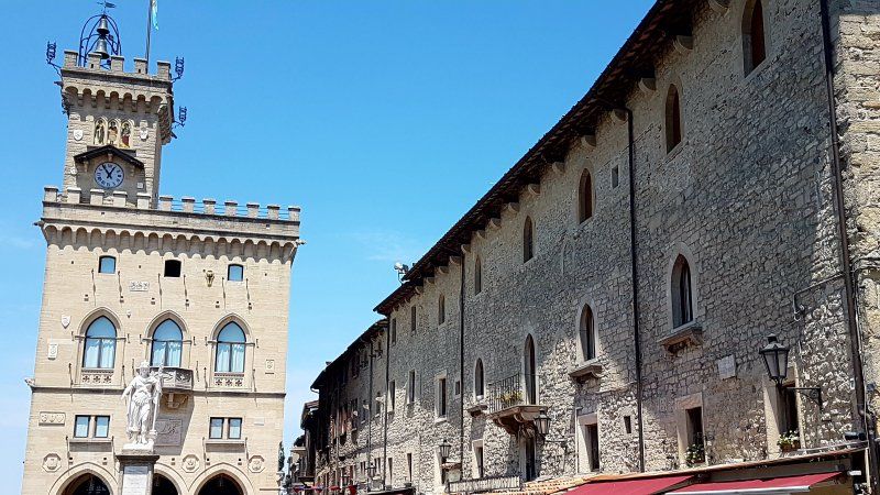
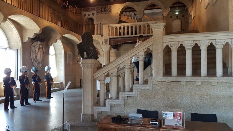
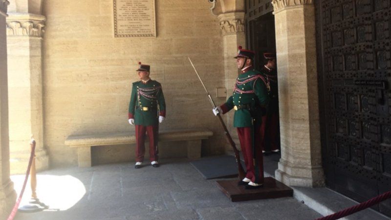
Today we travel to San Marino. A small country, surrounded by Italy. It is a nice walk largely through a forest to get there from the parking lot. first a coffee: but where do you have to pay? We are going to San Marino Citta Sounds a bit lame, but San Marino city is already quite an attraction in itself. If you choose to just stroll through the medieval town, you will quickly lose between two and four hours. When you also explore the smaller winding streets, it is sometimes like a maze. Fortunately, you always end up somewhere on one of the main streets. You will find restaurants all over the city. Sometimes with a beautiful view of San Marino Emilia Romagna and in good weather you can even look out on the beach and Rimini, located further on. Even before you enter San Marino through the gates, you will find a cafe where you can get the best gelattos (ice creams) according to the locals. Changing of the Guard. The heart of San Marino is the Piazza della Libertà or Freedom Square. The square is one of the most visited sights of San Marino together with the changing of the guard at the palace Palazzo Pubblico . On the square you will find the Statue of Liberty or Statua della Libertà as they call it here. The square and the Statue of Liberty represent San Marino's triumph through independence. The guards are standing in front of the Palazzo Pubblico , the city's town hall. This attractive building with special spaces is still often used for official state meetings. You can see the council chamber where San Marino's 60 MPs meet. We were not allowed to enter for unclear reasons, and we wait quietly to see what is to come. Gerard has some trouble with it and opens the door. This almost caused a riot. Close again soon! BASILICA DI SAN MARINO The Basilica di San Marino is a Catholic church of great historical and religious significance. This church is still in use. You can visit the Basillica di San Marino daily (free) when there are no services. After a long day we drive home with a tired, but satisfied feeling. source: aroundtheglobe.nl
Day
Cervia en Cecenatico
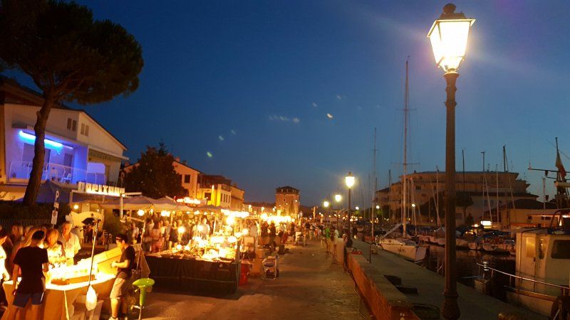
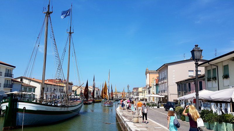
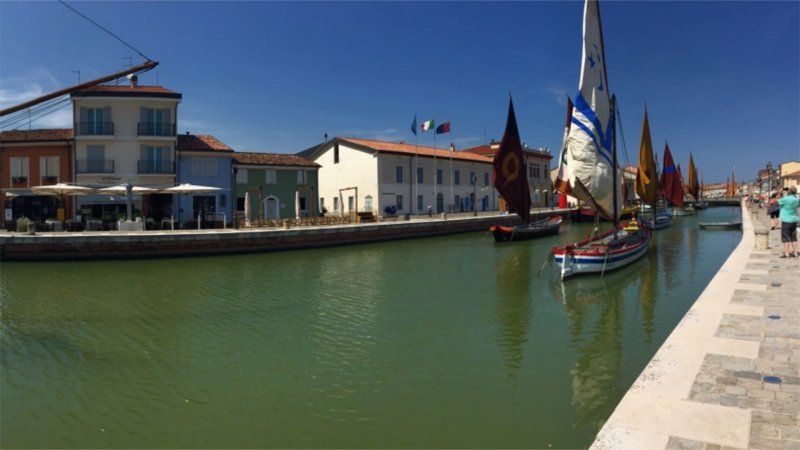
Today we first go to Cervia. We have a nice ice cream and stroll around.What a nice harbor! Cervia has been important for salt production for centuries, even the Etruscans and Romans were already working on it. Here began the Via Salaria, the ancient salt route from the salt pans to Rome. The 'white gold' was valuable because it was used and traded to preserve fresh produce. The salt was also a means of payment, just think of the word salary derived from the Latin Salarium! Later on, the area was fought over by many, from the Goths to the Venetians and even the Popes. Until the 1950s, Italian soldiers were still stationed to control the area. When refrigerators were gradually introduced into society in the last century, the salt was suddenly no longer so important. By the way, how is the salt produced? The water from the sea is pumped through a channel into the salt pans where the water evaporates in the sun and then the remaining water is pumped out. This way the salt remains in the salt pans to be harvested. Read more about the salt of Cervia. The old center of Cervia has a large square, the Piazza with the Duomo and the beautiful Town Hall and the salt warehouses that are located on the canal with the San Michele tower. Originally, the old center was in the middle of the salt pans a few kilometers inland. Due to the unhealthy living conditions, it was decided in 1698 to tear everything down and rebuild it at the current location. The 'new' center is built as a square fortress with gates that used to be closed after dark so that no one was allowed in or out.bron: dolcevita.nlWhen night falls we go to the market in Cesenatico. The market is on the banks of the romantic harbour, the Porto Canale. The harbor was designed by none other than Leonardo Da Vinci. A nice market, but it is really busy.
Day
Reisverslag
We travel on: today to Lake Garda. We are on the west side: on the beach. There is little cooling and temperatures are rising again. A week after we left, storms broke out on Lake Garda, including this campsite: hail and strong winds. We don't have that: sun, sun and more sun. Rina and Gerard sleep wonderfully in the tent, now with a view over Lake Garda. How beautiful and priceless is that! Fortunately, our spot has shade.
Campeggio Fontanelle
Del Magone 13, 25080, Moniga del Garda, Italien
45° 31' 28.9" N 10° 32' 33" E
45.5247000 10.5425000
• Head northwest on Via del Magone. Go for 390 m.
• Turn left onto Via Paolo Caccinelli. Go for 195 m.
• Continue on Piazza San Martino. Go for 126 m.
• Continue on Via Pompeo Molmenti. Go for 59 m.
• Turn left onto Via 25 Aprile. Go for 306 m.
• Take the 1st exit from roundabout onto Via Namponti. Go for 237 m.
• Turn left onto Via della Costa. Go for 150 m.
• Take the 3rd exit from roundabout onto Via Pergola (SPBS572) toward Verona/Brescia/Desenzano/A4/Padenghe D/G. Go for 451 m.
• Pass 4 roundabouts and continue on Via Antonio Meucci (SPBS572). Go for 3.1 km.
• Take the 3rd exit from roundabout onto Via Guglielmo Marconi (SPBS572) toward Aeroporto/Mi-Ve/A4/Desenzano. Go for 786 m.
• Take the 2nd exit from Via Guglielmo Marconi roundabout onto Via Guglielmo Marconi (SPBS572) toward Aeroporto/Mi-Ve/A4/Desenzano. Go for 957 m.
• Keep right onto Via Remato (SPBS572var) toward Autostrada/A4/Desenzano/Brescia/Verona. Go for 1.4 km.
• Pass 2 roundabouts and continue on Mini Tangenziale. Go for 1.4 km.
• Take the 2nd exit from roundabout onto Viale Guglielmo Marconi toward Milano-Venezia/A4. Go for 382 m.
• Continue toward Viale Guglielmo Marconi. Go for 38 m.
• Take the 3rd exit from roundabout onto Viale Guglielmo Marconi toward Brescia/Mantova/Verona. Go for 669 m.
• Take ramp toward Strada Statale Padana Superiore/SS11/Verona-Sirmione/Brescia-Lonato. Go for 335 m.
• Take the 4th exit from roundabout onto Strada Padana Superiore (SPBS11) toward Peschiera/Sirmione. Go for 9.3 km.
• Continue on SPBS11. Go for 3.2 km.
• Continue on Via Tangenziale (SR11). Go for 2.6 km.
• Keep left onto Paradiso di Sotto toward Autostrada/A22/Affi/SR450/Verona/SR11. Go for 621 m.
• Continue on SS11dir. Go for 3.7 km.
• Continue on Strada Regionale di Affi (SR450). Go for 12.6 km.
• Take the 1st exit from roundabout toward SS12/A22. Go for 359 m.
• Take the 2nd exit from roundabout onto A22 (Autostrada del Brennero) toward Milano/A4/Brennero. Go for 207 km.
• Continue on A13 (Brennerpass). Go for 34.5 km.
• Continue on A12 (Inntal Autobahn). Go for 74.9 km.
• Continue on A93 (Grenzübergang Kiefersfelden). Go for 24.8 km.
• Take the left exit toward München/Rosenheim-West onto A8. Go for 6.8 km.
• Take exit 100A toward Bad Feilnbach onto St2089. Go for 1.6 km.
• Take the 2nd exit from roundabout onto St2089. Go for 2.5 km.
• Turn right onto Reithof. Go for 307 m.
• Continue straight ahead. Go for 338 m.
• Turn left. Go for 140 m.
• Arrive at your destination on the left.
☍
396,7 km
(4 hrs. 15 min.)
Day
Reisverslag rondje Gardameer
Today we are going to drive along Lake Garda. It's a very touristy spot, but it's only when it's special isn't it?
We start on the north coast of Lake Garda, in Riva del Garda, a place where the blue of the water and the sky, the green of the Mediterranean vegetation and the white of the beaches create a work of art. We visit the Rocca of Riva, where the Museo dell'Alto Garda with the Pinacoteca found shelter: the Rocca, dating from 1124, houses a permanent collection of finds, dating from a time ranging from prehistoric times through the Middle Ages to on this day. In winter we also find the House of Santa Claus in the Rocca, much to the delight of the children.
We continue our exploration on foot through the historic center with its buildings in the Venetian-Venetian style; here we reach and then climb the Torre Apponale, a 34 meter high tower that rises in the Piazza 3 Novembre, the heart of the place. At the top of the tower rises the symbol of Riva, Anzolim, an angel of bronze. Another characteristic neighborhood of Riva is the Marocco district, where characteristic corners and typical views can be found.
After lunch we drive on and pass the most beautiful places. We get out regularly on the way. Similarly in Lazise. As soon as you get to the old port of Lazise you are probably sold in one fell swoop. The small harbor with terraces on one side and an old church on the other immediately enchants you. Lazise dates from the Middle Ages. The perimeter wall and the church of San Niccolò are remnants of the time, in which Lazise was an important trading place. This was the time when the city of Venice was one of the most important trading cities in Europe. Lazise also took advantage of this position of the city on stilts. Lazisse has passed away in the past centuries. Tourism has ensured that Lazise has regained much of the grandeur of yesteryear. Lazise has a historic center that is largely car-free. The squares and streets have largely been given a tourist function. Here you will find hotels, Bed & Breakfasts, shops with souvenirs, clothing, shoes and local products, ice cream parlors and a fair number of restaurants and bars. We eat an ice cream, some cooling is welcome.
As written, the old port of Lazise is one of the sights of the village. The San Niccolò church on the south side of the harbor dates from the twelfth century. In the medieval church there are a number of frescoes that can be attributed to the school of Giotto. When the church collapsed, the frescoes were badly damaged. Some of the frescoes have now been restored and can be admired on the interior walls of the church.
source: mooistedorpen.nl
visitrentinoinfo.nl
Day
Verona
Today one of the highlights of the trip: the Opera Aida in the beautiful Arena of Verona. Early in the evening we drive there and park the car. We're going to have dinner at the Arena nearby. The square is getting fuller and we walk to our entrance. We buy another pillow and go inside. It turns out we have a spot on the stairs! We don't think that's possible and we call someone from the organization. Eventually Rina and Gerard get other, better places. During the break there are still seats available next to them and the four of us sit in a row. What a spectacle, you are short of ears and eyes. The atmosphere, the story, the balmy evening. To never forget. After the performance we walk back to the car, but many go for supper first. Not us, it is still a short drive to the campsite.
Day
Sirmione
On our last day in Italy we take it easy. We go swimming and sunbathing. Gerard jumps into the water and has lost his glasses. Fortunately there is someone with a snorkel who helps to search and find it. You wouldn't find him anymore... in the evening we go to Sirmione. Another gem. The ice cream is delicious and the walk beautiful. We start at the castle. Sirmione is also called 'the pearl of Lake Garda'. it is located on a headland of up to five kilometers long, with the picturesque Sirmione at the end. Wherever you come from, you will soon see the outline of the town's most recognizable building, the Rocca Scaligera. It is good to see that the town can only be reached via an ancient drawbridge. The castle, built in the thirteenth century by Mastino della Scala, is one of the best preserved castles in all of Italy. We walk via the drawbridge through the busy center with all kinds of tourist shops and ice cream parlors. Clearly, Sirmione is a real tourist attraction. We wander through the streets, buy some Limoncello and enjoy with a big G.
Day
Reisverslag
We get up fairly early: it is a travel day. Via the Brenner Pass to Bad Feilnbach. The drive away from the campsite is a challenge: first straight up on the campsite, once outside it another climb over an unclear intersection. It went well, we made it. The Brenner pass is also no problem and we arrive at the campsite in the afternoon. We know from experience that there is "mittag ruhe". Once at the reception, our request for a place is met with laborious sighs and support. We're afraid there isn't much room. In the end it works and we are assigned a spot. The map shows where we need to go and we are going to drive. We drive over an almost empty campsite...... Can't understand what was so difficult!
Kaiser Camping Outdoor Resort
Reithof 2, 83075, Bad Feilnbach, Deutschland
47° 47' 19.7" N 12° 0' 18.4" E
47.7888000 12.0051000
• Head west. Go for 140 m.
• Turn right toward Reithof. Go for 338 m.
• Continue on Reithof. Go for 307 m.
• Turn left onto St2089. Go for 2.4 km.
• Take the 2nd exit from roundabout onto St2089. Go for 1.4 km.
• Turn left and take ramp onto A8 toward München. Go for 38.9 km.
• Take exit 95 toward Garmisch-P./München-Giesing/Mittl. Ring West onto A995. Go for 12.4 km.
• Continue on B13. Go for 1.8 km.
• Keep left onto Mittlerer Ring (B2R) toward Stuttgart/Lindau/A96/Garmisch-P./A95. Go for 1.8 km.
• Keep left onto Brudermühlstraße (B2R). Go for 858 m.
• Keep left onto Brudermühlstraße (B2R). Go for 1.7 km.
• Keep left onto Mittlerer Ring (B2R). Go for 1.6 km.
• Take ramp onto A96 toward Lindau. Go for 72.6 km.
• Take exit 20 toward Bad Wörishofen/Türkheim/Ettringen. Go for 360 m.
• Turn right onto St2015. Go for 2.7 km.
• Take the 1st exit from roundabout onto Rudolf-Diesel-Straße (MN23) toward Mindelheim/Kirchdorf/Bad Wörishofen. Go for 797 m.
• Turn right onto Gottlieb-Daimler-Straße. Go for 439 m.
• Continue on Walter-Schulz-Straße. Go for 169 m.
• Arrive at Walter-Schulz-Straße.
☍
140,8 km
(1 hrs. 33 min.)
Day
Bergtesgaden
Today we make a trip to Bergtesgaden, the Obersalzberg, Hitler's country residence. We are going to visit the Eagle's Nest. You have to park your car and a bus will take you up. Once at the top you will be dropped off at a tunnel that leads to the elevator. You go upstairs and then you understand why the Kehlsteinhaus was built here. The view at this height is simply beautiful. Martin Bormann (1900-1945), Hitler's private secretary, felt the same way. In thirteen months, as a gift for Hitler's fiftieth birthday in 1939, he had a house built on the 1,834-metre-high summit of the Kehlstein. must have been. Day and night, 4000 workers work on the road and the house itself. But the Führer doesn't like it afterwards. His claustrophobia makes the elevator ride to the top no fun. A glittering copper elevator with mirrors can do little to change that. Once at the top of the mountain, Hitler's fear of heights prevents him from enjoying the wide panorama. So for Hitler the house is not a success; he hardly stays there. He would much rather be in the Berghof, his own house nearby. Hitler gets to know the enchantingly beautiful surroundings by visiting the poet Dietrich Eckart (1868-1923). Eckart is a close friend of Hitler and the first to call him Führer in 1921. Over tea at Eckart's, Hitler discovers how beautiful the surroundings of the Obersalzberg are. In 1936, the modest country house that originally stood on the site of the Berghof is no longer large enough for Hitler to take on his new role as Führer. That is why he has it converted into a villa with thirty rooms and a bowling alley in the basement.
The great hall of the Berghof. The painting to the right of the fireplace, Venus & Amor by Paris Bordone, is transferred by the Americans to the National Museum in Warsaw in May 1946. It was supposed to serve as a 'make-up' for all the art that was destroyed in Poland during the German occupation.
FührersperrgebietThe renovation of the Berghof is the starting signal for a rigorous change on the Obersalzberg. The lovely mountain village of Berchtesgaden changes into Führersperrgebiet, where houses for Hermann Göring and Albert Speer, among others, are built. The four hundred inhabitants of the village, who have often lived in this area for generations, are being expelled. A completely self-sufficient complex with SS barracks, hospital, hotel, crèche and theater is being built. The Führersperrgebiet is fenced off and guarded by SS men. When Hitler moves from Berlin to his Berghof, his entire retinue goes with him. In 1943, the air war escalates. The Berghof is painted in camouflage colours. That does not alter the fact that the Obersalzberg is an easy target for bombers. Therefore, a huge underground village will be built within two years. Five kilometers of corridors with apartments, offices and kitchens: everyone should be able to live underground.Hitler as a nature loverAs said, the Eagle's Nest is not the power center of the Third Reich. Hitler rarely visits. Nevertheless, an important role is reserved for the entire area on the Obersalzberg. Hitler spends more than a third of his reign there; many important decisions are made. At the same time, the Nazi propaganda machine makes grateful use of the beautiful mountain landscapes to portray Hitler as a nature lover, child friend and great statesman. After July 1944, Hitler never visits the Obersalzberg again. On April 22, 1945, a small plane left Berlin for the area. Hitler ordered that all his personal papers be burned. Three days later, the British bomb the area. The Berghof is destroyed, the Kehlsteinhaus survives the bombardment. After the war, the village of Berchtesgaden tries to continue the tradition of spa and to forget the brown past as quickly as possible. Shrewd businessmen see opportunities in the area and organize trips for history buffs, Nazi adepts and right-wing extremists. That is why the Americans are thoroughly cleaning up the area. The bunker under the area and the Kehlsteinhaus are preserved. Since April 1952, the Kehlsteinhaus has been used as a restaurant. The main income for the area comes from the Americans. They use the area around Berchtesgaden as an Armed Forces Recreation Center and build tennis courts, golf courses and ski lifts.
Adolf Hitler and Eva Braun with their dogs at the Berghof (Photo: Wikimedia)
Cozy café-restaurantIn 1997, the entire area on the Obersalzberg is released. Since then, the Kehlsteinhaus has been – to be honest – a cozy café-restaurant. Especially the beautiful view is emphasized there. There is little that immediately reminds of history. The red marble hearth is a gift from Mussolini; it doesn't get much more direct. For an explanation of the area you have to be in the documentation center. On the site of a Gästehaus in Nazi times, there is now an exhibition about the Hitler regime. You reach part of the immense bunker complex through this documentation centre. With the explanation of the Nazi terror still in mind, you walk through the damp and gray air raid shelter. The contrast with the beautiful panoramic view on top of the Kehlstein could not be greater. As a visitor to the Eagle's Nest and the Führersperrgebiet, that impression remains with you: a beautiful environment with a bitter taste.
Day
Rondrit in de omgeving
We drive around and sail into the Markus Wasmeier museum. a really nice open air museum where the times of the past are shown. There are several buildings to visit and the whole is well organized and spacious. We have a nice number of hours there.
We drive further to the Tegersee and have a coffee with a delicious point. Like only you can do in Germany!
Day
Reisverslag
We travel on. We still want to visit Schloss Neuschwanstein and decide to look for a campsite closer. The ride goes smoothly and everything goes well at the campsite. There is a cozy lounge and we play a game of Keezen and 51tigen.
Kur und Vitalcamping
Walter-Schulz-Str. 4-6, 86825, Bad Wörishofen, Deutschland
48° 1' 29.3" N 10° 35' 57.5" E
48.0248000 10.5993000
• Head south on Walter-Schulz-Straße. Go for 47 m.
• Turn right onto Max-Planck-Straße. Go for 352 m.
• Turn right onto Zeppelinstraße. Go for 60 m.
• Turn right onto Kirchdorfer Straße (MN23). Go for 1.4 km.
• Take the 2nd exit from roundabout onto MN23 toward Kirchdorf/Mindelheim/Rammingen. Go for 953 m.
• Take the 1st exit from roundabout onto Im Hartfeld (St2518). Go for 2.3 km.
• Take the 1st exit from roundabout toward Lindau/München/Kaufbeuren/Bad Wörishofen. Go for 41 m.
• Turn right onto St2015. Go for 56 m.
• Take ramp onto A96 toward Lindau/Memmingen. Go for 36.4 km.
• Take exit 13 toward Würzburg/Ulm/Stuttgart onto A7. Go for 53.8 km.
• Take exit 120 toward Stuttgart/Ulm onto A8. Go for 101 km.
• Continue on A8 toward Karlsruhe/Basel/Leonberg-West. Go for 53.8 km.
• Take the exit toward Frankfurt a.M./Mannheim/Karlsruhe/Landau (Pfalz) onto A5 (Autobahndreieck Karlsruhe). Go for 37.6 km.
• Take exit 40 toward Mannheim/Koblenz/Saarbrücken/A61 onto A6. Go for 7.7 km.
• Take exit 30 toward Koblenz/Saarbrücken/Ludwigshafen/Speyer onto A61. Go for 103 km.
• Take exit 47 toward Waldlaubersheim/Windesheim/Guldental/Wallhausen. Go for 282 m.
• Turn left onto Windesheimer Straße (L236) toward Bad Kreuznach/Roxheim/Wallhausen/Guldental/Windesheim/Spabrücken/Schweppenhausen/Gewerbepark Waldlaubersheim. Go for 209 m.
• Take the 2nd exit from roundabout onto Windesheimer Straße (L236) toward Bad Kreuznach/Windesheim. Go for 161 m.
• Take the 1st exit from roundabout onto K29. Go for 2.0 km.
• Turn right onto Naheweinstraße (L242). Go for 1.1 km.
• Arrive at Naheweinstraße (L242). Your destination is on the left.
☍
401,8 km
(3 hrs. 33 min.)
Day
Slot Hohenschwangau
We drive to Fussen and once we arrive at the ticket office it turns out that we cannot buy tickets for Schloss Neuschwanstein. What a downer. We can, however, visit Schloss Hohenschwangau. Just do that then. We go up with horse and carriage. The warm weather has now turned and we regularly have a shower. We walk the last bit up and stand in line for our excursion.
The oldest mention of castles on the site of today's Neuschwanstein Castle dates from 1090. This refers to the double castles of Vorderschwangau and Hinterschwangau. The ruins of these castles stood on the rocks until the construction of the current castle. The lords of Schwangau lived on this double bucht. The most famous resident from that time is the minstrel Hiltbolt von Schwangau (*ca. 1190-1256). In 1363 Tyrol came under Habsburg rule and in 1397 the name Schwanstein is mentioned for the first time, the current Hohenschwangau Castle, under the older double castle that was more difficult to reach. After Herr Ulrich von Schwangau divided his reign between his four sons in 1428, the once proud family fell into disrepair. In 1440 the castle was sold to the duke of Bavaria. In 1536 the genus became extinct. The double castle and Hohenschwangau Castle fell into disrepair more and more. The lock was used in the seventeenth century for bear hunting. With the Thirty Years' War (1618-1648) the decline really continued and in 1743 the castle was also plundered during the war for the Austrian succession. It was not until 1803 that Hohenschwangau Castle finally came into the possession of the Kingdom of Bavaria. In 1820 the castle was sold by the king for 200 guilders to be demolished. But in 1821, Prince Lodewijk van Oettingen-Wallerstein bought the castle for 225 guilders to save it from demolition, so the location was beautiful.
Photo: www.bavaria.by
Crown Prince Maximilian was very fond of Schloss Hohenschwangau and its location and acquired the castle for himself in 1832. He renamed the lock to its current name. Maximiliaan had the castle renovated in neo-Gothic style in 1837 by the architect and set builder Domenico Quaglio, assisted by the architect Georg Friedrich Ziebland. When Maximilian became king in 1848, the castle served as the summer residence of the royal family. The castle has been used as a museum since 1923. In today's Hohenschwangau Castle, part of the outer walls from the period 1537 to 1547 have been preserved. The four-storey main building in neo-Gothic style has a facade painted yellow. The building has three round towers and the gatehouse has three floors. The museum is located in the main building. The Biedermeier-style furnishings have been left untouched. The more than ninety murals in the building were executed by Moritz von Schwind and Ludwig Lindenschmit the Elder, aided by Wilhelm Lindenschmit the Elder. The themes of the paintings are the history of the castle and medieval epics, which in turn were the inspiration for the composer Richard Wagner.
source: romanticstrasse.nl
Day
Reisverslag
Today we drive to Schweppenhausen. We also looked great on the outward journey. Setting up the tent has now become routine and is ready quickly. We eat one last schnitzel and go to sleep.
Camping Aumühle, Naheweinstraße 65, Schweppenhausen, Duitsland
Naheweinstraße 65, 55444 Schweppenhausen, Duitsland
49° 56' 1" N 7° 47' 30" E
49.9336111 7.7916667
• Head northwest on Naheweinstraße (L242). Go for 2.1 km.
• Turn right onto Marktplatz (L214). Go for 214 m.
• Continue on Binger Straße (L214). Go for 1.7 km.
• Take the 2nd exit from roundabout onto L214. Go for 445 m.
• Take ramp onto A61 toward Köln/Koblenz. Go for 139 km.
• Keep right onto A61 (Autobahndreieck Erfttal) toward Venlo/Mönchengladbach/Aachen. Go for 34.2 km.
• Take left exit 16 toward Venlo/Düsseldorf/Mönchengladbach/A61 onto A44. Go for 7.5 km.
• Take the exit toward Heinsberg/Venlo/Mönchengladbach/A61 onto A46. Go for 4.0 km.
• Take exit 10 toward Venlo/Mönchengladbach onto A61. Go for 37.2 km.
• Continue on A74. Go for 1.8 km.
• Continue on A73 (Knooppunt Tiglia). Go for 4.5 km.
• Take exit 12+13 toward Grubbenvorst/Eindhoven. Go for 4.2 km.
• Turn left onto Greenportlane (N295). Go for 260 m.
• Turn left toward Industrieterrein Venlo 3200-3400/Industrieterrein Venlo 3900-4000/Fresh Park Gate 2+3/Villa Flora/Innovatoren/Grubbenvorst. Go for 442 m.
• Turn right onto Venrayseweg. Go for 1.6 km.
• Turn left onto Horsterweg. Go for 151 m.
• Arrive at Horsterweg. Your destination is on the left.
☍
239,4 km
(2 hrs. 14 min.)
Day
Reisverslag
After a wonderful last night at the Camping we are back in the Netherlands. The journey is going well and we arrive smoothly.
What an experience we have had in the last 4 weeks. We enjoyed Italy, the weather and each other.
Until next time.
Camping Californië, Horsterweg, Grubbenvorst, Nederland
Horsterweg 23, 5971 ND Grubbenvorst, Nederland
51° 25' 14.4" N 6° 6' 23.9" E
51.4206750 6.1066255