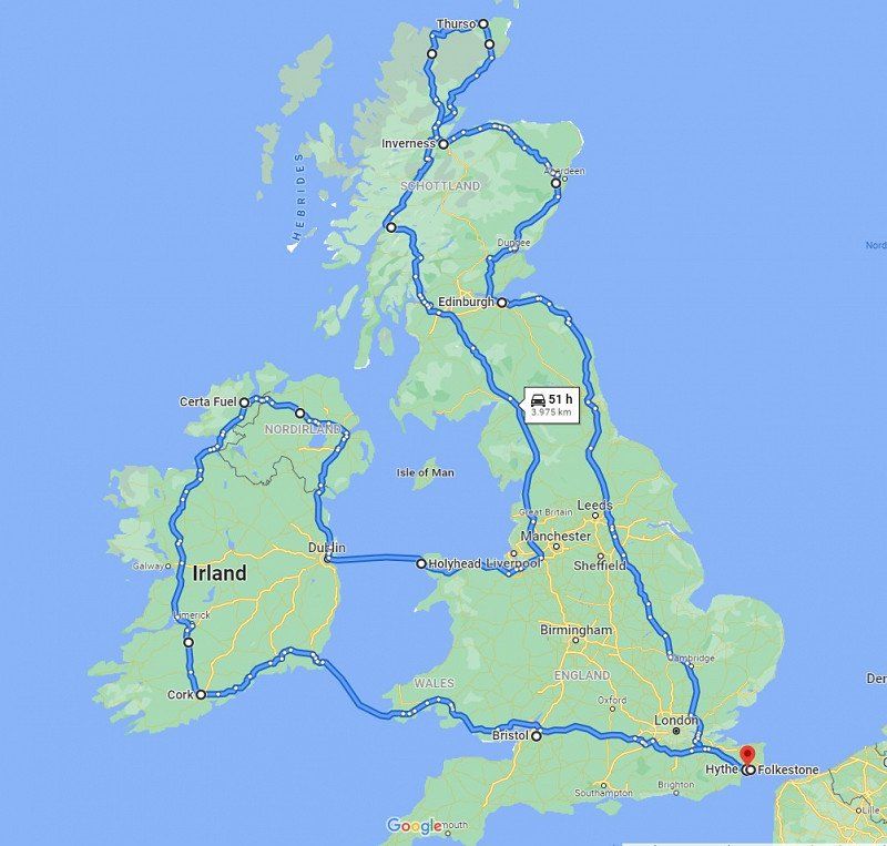
We are planning a UK - Ireland round trip in August 2022 ??
We have already thought about the tour roughly (see the following picture).
Since we have only done one city trip in London so far, we are attracted to the rest of the surrounding area with its historic old castles/palaces, wide wild landscapes and cities that want to be explored.
A detour to the filming locations of HP ⚡ is immediately connected with ?
We look forward to your SUGGESTIONS, INSIDER TIPS, ROUTE SUGGESTIONS, MUST SEE POINTS
as well as information on driving on the left-hand side of the road?
Thanks in advance !
Folkestone Central Railway Station (Stop B), Folkestone, Vereinigtes Königreich
Folkestone CT20 2QN, Vereinigtes Königreich
51° 4' 57.2" N 1° 10' 15.3" E
51.0825650 1.1709060
• Head north on Cheriton Road (A259). Go for 70 m.
• Take the 1st exit from roundabout onto Cheriton Road (A2034) toward Ashford/Channel Tunnel/Dover/A20/(M20)/Canterbury/(A260). Go for 1.1 km.
• Turn right onto Cherry Garden Avenue (A2034). Go for 947 m.
• Turn left and take ramp onto M20 toward London/Channel Tnl/Ashford. Go for 80.3 km.
• Take exit 1 toward Dartford Crossing/M25(N)/C. London/(A2) onto M25. Go for 6.7 km.
• Continue on A282. Go for 7.4 km.
• Continue on M25 toward M11/M1/Stansted Airport. Go for 25.4 km.
• Take exit 27 toward M11(S)/London (NE & C)/Stansted Airport/Harlow/Cambridge onto M11. Go for 46.1 km.
• Keep right onto M11 toward Cambridge. Go for 13.1 km.
• Take exit 11 toward Cambridge (South)/Harston. Go for 451 m.
• Take the 3rd exit from roundabout onto Hauxton Road (A1309) toward Cambridge. Go for 2.7 km.
• Continue on Trumpington Road (A1134). Go for 2.0 km.
• Take the 2nd exit from roundabout onto Trumpington Road (A603). Go for 66 m.
• Take the 2nd exit from roundabout onto Lensfield Road (A603). Go for 862 m.
• Turn left onto Parkside. Go for 321 m.
• Continue on Parker Street. Go for 134 m.
• Take the 1st exit from roundabout onto Parker Street. Go for 48 m.
• Continue on Drummer Street. Go for 53 m.
• Turn left onto Emmanuel Street. Go for 147 m.
• Turn right onto St Andrew's Street. Go for 171 m.
• Arrive at St Andrew's Street. Your destination is on the right.
☍
188,2 km
(1 hrs. 56 min.)
Cambridge, Vereinigtes Königreich
52° 12' 19.2" N 0° 7' 18.5" E
52.2053370 0.1218170
• Head northwest on St Andrew's Street.
• Turn slightly right onto Hobson Street. Go for 197 m.
• Continue on King Street. Go for 421 m.
• Turn slightly left toward Short Street. Go for 7 m.
• Take the 3rd exit from roundabout onto Victoria Avenue. Go for 742 m.
• Turn left onto Chesterton Road (A1303). Go for 141 m.
• Keep right onto Croftholme Lane (A1134). Go for 82 m.
• Keep left onto Victoria Road (A1134). Go for 942 m.
• Turn right onto Huntingdon Road (A1307). Go for 3.6 km.
• Take the 1st exit from roundabout onto A1307. Go for 579 m.
• Take the 2nd exit from roundabout. Go for 420 m.
• Take ramp onto Huntingdon Road (A14). Go for 2.7 km.
• Keep right onto Huntingdon Road (A14) toward The North/The Midlands/Huntingdon. Go for 19.7 km.
• Take ramp onto A1 toward The North/Peterborough. Go for 6.3 km.
• Keep right onto A1(M) toward The North/Peterborough. Go for 20.7 km.
• Continue on Great North Road (A1). Go for 117 km.
• Keep right onto A1(M) (Doncaster By-pass) toward The North/Doncaster. Go for 37.2 km.
• Keep right onto A1(M) toward The North/Wetherby/Manchester/Leeds/(M62). Go for 16.6 km.
• Take the exit onto A1(M) (Aberford By Pass). Go for 134 km.
• Continue on A1. Go for 7.3 km.
• Take ramp onto A184 toward Central Newcastle/Central Gateshead. Go for 2.1 km.
• Keep right onto A189 toward Newcastle. Go for 2.1 km.
• Turn right onto Gallowgate (B1311). Go for 274 m.
• Turn left onto Percy Street (B1307). Go for 41 m.
• Turn left onto Leazes Park Road. Go for 238 m.
• Turn slightly right onto Leazes Lane. Go for 106 m.
• Turn right onto Queen Victoria Road. Go for 133 m.
• Turn right. Go for 22 m.
• Arrive at your destination on the right.
☍
373,5 km
(3 hrs. 34 min.)
Newcastle upon Tyne, Vereinigtes Königreich
54° 58' 41.7" N 1° 37' 4" W
54.9782520 -1.6177800
• Head toward Queen Victoria Road. Go for 22 m.
• Turn right onto Queen Victoria Road. Go for 363 m.
• Take the 1st exit from roundabout onto Claremont Road (B1318). Go for 255 m.
• Take the 3rd exit from roundabout onto A167. Go for 2.5 km.
• Keep right onto A167 toward Morpeth/(A1)/Jedburgh/(A696)/Airport. Go for 682 m.
• Pass 3 roundabouts and continue on Redcliffe Way (A167). Go for 1.3 km.
• Take the 4th exit from roundabout toward The North/Morpeth. Go for 510 m.
• Keep left toward A1. Go for 410 m.
• Continue on A1. Go for 91.5 km.
• Take the 1st exit from roundabout onto A1 toward Edinburgh. Go for 3.4 km.
• Take the 2nd exit from roundabout onto A1 toward Edinburgh/Berwick Train Station. Go for 4.0 km.
• Pass 5 roundabouts and continue on Milton Link (A1). Go for 82.6 km.
• Turn left onto Milton Road (A1) toward City Centre. Go for 3.6 km.
• Turn left onto London Road (A1). Go for 1.3 km.
• Turn slightly left onto Montrose Terrace (A1). Go for 980 m.
• Take the 1st exit from roundabout onto Regent Road (A1). Go for 391 m.
• Arrive at Waterloo Place (A1). Your destination is on the left.
☍
193,7 km
(2 hrs. 4 min.)
Edinburgh, Vereinigtes Königreich
55° 57' 11.7" N 3° 11' 17.8" W
55.9532520 -3.1882670
• Head toward Leith Street on Waterloo Place (A1). Go for 48 m.
• Continue on Princes Street. Go for 275 m.
• Turn right onto South St David Street. Go for 110 m.
• Continue on St Andrew Square. Go for 131 m.
• Continue on North St David Street. Go for 102 m.
• Turn left onto Queen Street. Go for 819 m.
• Continue on St Colme Street. Go for 156 m.
• Turn left onto Ainslie Place. Go for 61 m.
• Turn left onto Great Stuart Street. Go for 92 m.
• Turn left onto Randolph Crescent. Go for 93 m.
• Turn right onto Queensferry Street (A90). Go for 1.4 km.
• Take the 2nd exit from roundabout onto Queensferry Road (A90) toward Forth Road Bridge/(A720)/Blackhall. Go for 10.2 km.
• Take ramp onto A90. Go for 2.8 km.
• Keep right onto M90. Go for 52.2 km.
• Continue on A90. Go for 25.0 km.
• Pass 4 roundabouts and continue on Kingsway (A90). Go for 7.6 km.
• Turn left onto Forfar Road (A90) toward Aberdeen/Forfar. Go for 1.3 km.
• Pass 2 roundabouts and continue on Forfar Road (A90). Go for 79.7 km.
• Keep right onto A92 toward Aberdeen. Go for 18.4 km.
• Take the 3rd exit from roundabout onto Great Southern Road (B9077) toward Tullos Ind Est. Go for 713 m.
• Take the 1st exit from roundabout onto Great Southern Road (B9077). Go for 284 m.
• Take the 3rd exit from roundabout onto Riverside Drive. Go for 1.4 km.
• Take the 2nd exit from roundabout onto North Esplanade West (A956). Go for 1.3 km.
• Turn right onto Trinity Quay (A956). Go for 577 m.
• Turn left onto Commerce Street (A956). Go for 154 m.
• Take the 1st exit from roundabout onto East North Street (A956). Go for 210 m.
• Continue on West North Street. Go for 24 m.
• Arrive at West North Street. Your destination is on the left.
☍
205,0 km
(2 hrs. 10 min.)
Aberdeen, Vereinigtes Königreich
57° 8' 59" N 2° 5' 39.4" W
57.1497170 -2.0942780
• Head toward Littlejohn Street on West North Street. Go for 581 m.
• Take the 3rd exit from Mounthooly Roundabout roundabout onto Causewayend (A96). Go for 1.9 km.
• Take the 2nd exit from roundabout onto Great Northern Road (A96). Go for 2.0 km.
• Take the 2nd exit from Haudagain Roundabout roundabout onto Auchmill Road (A96) toward Inverness/Airport. Go for 2.1 km.
• Turn left onto Inverurie Road (A96) toward Inverness/Elgin/Airport. Go for 634 m.
• Take the 2nd exit from roundabout onto Inverurie Road (A96) toward Inverness/Elgin/Airport. Go for 1.9 km.
• Take the 2nd exit from Craibstone Roundabout roundabout onto A96 toward Inverness. Go for 4.6 km.
• Pass 5 roundabouts and continue on A96. Go for 13.1 km.
• Take the 3rd exit from roundabout onto A96 toward Inverness/Keith. Go for 34.6 km.
• Take the 2nd exit from roundabout onto A96 toward Inverness. Go for 1.3 km.
• Continue on A96 toward Inverness. Go for 27.5 km.
• Pass 11 roundabouts and continue on South College Street (A96). Go for 14.8 km.
• Take the 3rd exit from roundabout onto Alexandra Road (A96) toward Inverness. Go for 476 m.
• Take the 1st exit from roundabout onto Alexandra Road (A96) toward Inverness. Go for 323 m.
• Take the 1st exit from roundabout onto Alexandra Road (A96) toward Inverness/Perth/(A941)/(A95). Go for 155 m.
• Take the 3rd exit from High Street roundabout onto High Street (A96) toward Inverness. Go for 377 m.
• Take the 3rd exit from roundabout onto West Road (A96) toward Inverness. Go for 15.6 km.
• Take the 2nd exit from roundabout onto A96 toward Inverness. Go for 1.7 km.
• Pass 4 roundabouts and continue on Forres Road (A96). Go for 17.9 km.
• Take the 1st exit from roundabout onto King Street (A96) toward Inverness. Go for 2.8 km.
• Take the 2nd exit from roundabout onto A96 toward Inverness. Go for 9.9 km.
• Continue toward Inverness. Go for 44 m.
• Take the 2nd exit from Airport Roundabout roundabout onto A96 toward Inverness. Go for 8.7 km.
• Take the 2nd exit from roundabout onto A96 toward Inverness. Go for 999 m.
• Take the 2nd exit from roundabout onto A96 toward Inverness. Go for 815 m.
• Take the 3rd exit from Raigmore Interchange roundabout onto A9 toward Fort William/(A82)/Ullapool/(A835). Go for 1.9 km.
• Take the 2nd exit from Longman Roundabout roundabout onto A9 toward Thurso/Ullapool/(A835). Go for 9.6 km.
• Take the 3rd exit from roundabout onto A9. Go for 10.5 km.
• Take the 2nd exit from Ardullie Roundabout roundabout onto A9. Go for 26.5 km.
• Take the 1st exit from Nigg Roundabout roundabout onto A9. Go for 9.9 km.
• Take the 3rd exit from Meikle Ferry Roundabout roundabout onto A9. Go for 51.8 km.
• Take the 2nd exit from roundabout onto A9. Go for 28.5 km.
• Turn left onto A9. Go for 27.9 km.
• Turn left onto A9. Go for 9.4 km.
• Continue on Sir Georges Street (A9). Go for 110 m.
• Arrive at Sir Georges Street (A9). Your destination is on the right.
☍
341,1 km
(4 hrs. 40 min.)
Thurso, Vereinigtes Königreich
58° 35' 36.8" N 3° 31' 19.5" W
58.5935660 -3.5220800
• Head northwest on Sir Georges Street (A9).
• Turn right onto Traill Street (A9). Go for 163 m.
• Continue on Olrig Street (A9). Go for 405 m.
• Continue on Smith Terrace (A9). Go for 304 m.
• Continue on A9. Go for 371 m.
• Continue on A836. Go for 7.5 km.
• Continue on Bridge of Forss (A836). Go for 71 m.
• Continue on A836. Go for 4.7 km.
• Continue on Buldoo (A836). Go for 144 m.
• Continue on A836. Go for 2.5 km.
• Continue on Isauld (A836). Go for 154 m.
• Continue on A836. Go for 12.1 km.
• Continue on Portskerra (A836). Go for 120 m.
• Continue on A836. Go for 20.8 km.
• Continue on Achina (A836). Go for 172 m.
• Continue on A836. Go for 698 m.
• Turn right onto A836. Go for 800 m.
• Continue on Leckfurin (A836). Go for 158 m.
• Continue on A836. Go for 12.0 km.
• Continue on Strathtongue (A836). Go for 88 m.
• Continue on A836. Go for 4.7 km.
• Continue on A838. Go for 1.2 km.
• Arrive at A838.
☍
69,2 km
(1 hrs. 8 min.)
Tongue, Lairg, Vereinigtes Königreich
Tongue, Lairg IV27, Vereinigtes Königreich
58° 28' 34.1" N 4° 25' 2.9" W
58.4761469 -4.4174720
• Head northeast on A838. Go for 1.2 km.
• Continue on A836. Go for 4.7 km.
• Continue on Strathtongue (A836). Go for 88 m.
• Continue on A836. Go for 10.3 km.
• Turn right onto B871. Go for 3.5 km.
• Continue on Achargary (B871). Go for 128 m.
• Continue on B871. Go for 4.8 km.
• Continue on Rhifail (B871). Go for 150 m.
• Continue on B871. Go for 754 m.
• Continue on Rough Haugh (B871). Go for 131 m.
• Continue on B871. Go for 2.0 km.
• Continue on Skail (B871). Go for 121 m.
• Continue on B871. Go for 3.4 km.
• Continue on B873. Go for 58 m.
• Continue on Syre (B873). Go for 146 m.
• Continue on B873. Go for 18.2 km.
• Turn left onto A836. Go for 13.4 km.
• Continue on Crask Inn (A836). Go for 163 m.
• Continue on A836. Go for 9.4 km.
• Continue on Rhian (A836). Go for 116 m.
• Continue on A836. Go for 2.8 km.
• Continue on Dalnessie (A836). Go for 148 m.
• Continue on A836. Go for 3.3 km.
• Continue on Dalchork (A836). Go for 316 m.
• Continue on A836. Go for 3.2 km.
• Continue on Lairg Lodge (A836). Go for 153 m.
• Continue on A836. Go for 1.8 km.
• Turn right onto A839. Go for 12.6 km.
• Turn right onto A837. Go for 1.4 km.
• Continue on Invercassley (A837). Go for 284 m.
• Continue on A837. Go for 9.1 km.
• Continue on Oykel Bridge (A837). Go for 300 m.
• Continue on A837. Go for 2.9 km.
• Continue on Lubcroy (A837). Go for 152 m.
• Continue on A837. Go for 13.3 km.
• Continue on Altnacealgach (A837). Go for 199 m.
• Continue on A837. Go for 9.6 km.
• Continue on Stronchrubie (A837). Go for 137 m.
• Continue on A837. Go for 2.5 km.
• Continue on Inchnadamph (A837). Go for 165 m.
• Continue on A837. Go for 3.1 km.
• Turn right onto A894. Go for 10.1 km.
• Continue on Unapool (A894). Go for 240 m.
• Continue on A894. Go for 1.1 km.
• Continue on Kylesku Bridge (A894). Go for 150 m.
• Arrive at Kylesku Bridge (A894). Your destination is on the left.
☍
151,8 km
(2 hrs. 37 min.)
Kylesku Bridge, Kylesku Bridge, Lairg, Vereinigtes Königreich
Kylesku Bridge, Lairg IV27 4HW, Vereinigtes Königreich
58° 15' 25.3" N 5° 1' 24.6" W
58.2570239 -5.0234895
• Head southeast on Kylesku Bridge (A894). Go for 150 m.
• Continue on A894. Go for 1.1 km.
• Continue on Unapool (A894). Go for 240 m.
• Continue on A894. Go for 10.1 km.
• Turn left onto A837. Go for 3.1 km.
• Continue on Inchnadamph (A837). Go for 165 m.
• Continue on A837. Go for 2.5 km.
• Continue on Stronchrubie (A837). Go for 137 m.
• Continue on A837. Go for 9.6 km.
• Continue on Altnacealgach (A837). Go for 199 m.
• Continue on A837. Go for 13.3 km.
• Continue on Lubcroy (A837). Go for 152 m.
• Continue on A837. Go for 2.9 km.
• Continue on Oykel Bridge (A837). Go for 300 m.
• Continue on A837. Go for 9.1 km.
• Continue on Invercassley (A837). Go for 284 m.
• Continue on A837. Go for 12.5 km.
• Keep right onto A837. Go for 1.2 km.
• Turn right onto A836. Go for 1.0 km.
• Continue on Invershin Station (A836). Go for 290 m.
• Continue on A836. Go for 2.9 km.
• Continue on Lairg Road (A836). Go for 2.1 km.
• Continue on A836. Go for 16 m.
• Turn right onto A836. Go for 306 m.
• Continue on South Bonar Industrial Estate (A836). Go for 184 m.
• Continue on A836. Go for 5.7 km.
• Continue on Fearn Lodge (A836). Go for 111 m.
• Continue on A836. Go for 109 m.
• Turn right onto B9176. Go for 8.0 km.
• Continue on Aultnamain Inn (B9176). Go for 168 m.
• Continue on B9176. Go for 8.4 km.
• Continue on Stittenham (B9176). Go for 94 m.
• Continue on B9176. Go for 7.7 km.
• Turn right onto A9. Go for 7.1 km.
• Pass 2 roundabouts and continue on A9. Go for 20.1 km.
• Take the 3rd exit from Longman Roundabout roundabout onto Longman Road (A82) toward Inverness/FT. William/Longman Ind. Est. Go for 833 m.
• Pass 2 roundabouts and continue on Longman Road (A82). Go for 847 m.
• Take the 1st exit from Shore Street Roundabout roundabout onto Chapel Street (B865) toward Town Centre/Dores/Foyers/(B862). Go for 239 m.
• Turn right onto Friars Lane (B862). Go for 812 m.
• Turn right onto Haugh Road (B862). Go for 3.2 km.
• Take the 2nd exit from Holm Roundabout roundabout onto B862. Go for 9.3 km.
• Turn right onto B852. Go for 199 m.
• Continue on Strath Gardens (B852). Go for 39 m.
• Continue on B852. Go for 7.1 km.
• Continue on Whitefield (B852). Go for 322 m.
• Continue on B852. Go for 797 m.
• Arrive at B852.
☍
154,9 km
(2 hrs. 25 min.)
Loch Ness, Vereinigtes Königreich
57° 19' 22.3" N 4° 25' 27.8" W
57.3228575 -4.4243817
• Head southwest on B852. Go for 4.8 km.
• Continue on Hillhead (B852). Go for 58 m.
• Continue on B852. Go for 50 m.
• Continue on South Loch Ness Trail (B852). Go for 258 m.
• Continue on B852. Go for 1.6 km.
• Continue on General Wades Military Road (B852). Go for 77 m.
• Continue on B852. Go for 213 m.
• Continue on Easter Boleskine (B852). Go for 194 m.
• Continue on B852. Go for 2.2 km.
• Continue on Glenlia (B852). Go for 213 m.
• Continue on B852. Go for 3.8 km.
• Turn right onto B862. Go for 6.1 km.
• Continue on Knockie Lodge (B862). Go for 149 m.
• Continue on B862. Go for 5.8 km.
• Continue on Glendoebeg (B862). Go for 124 m.
• Continue on B862. Go for 1.3 km.
• Continue on Glendoe Lodge (B862). Go for 89 m.
• Continue on B862. Go for 3.1 km.
• Continue on Glendoe Road (B862). Go for 216 m.
• Turn left onto Fort William Road (A82). Go for 48.1 km.
• Take the 1st exit from Lochy Bridge Roundabout roundabout onto A82 toward A' Chrìon-Làraich/Crianlarich/Meadhan A' Bhaile/Town Centre/An Gearasdan/Fort William. Go for 727 m.
• Take the 4th exit from roundabout onto North Road (A82). Go for 1.0 km.
• Take the 1st exit from roundabout onto A82 toward A' Chrìon-Làraich/Crianlarich/Meadhan A' Bhaile/Town Centre. Go for 206 m.
• Take the 3rd exit from roundabout onto Belford Road (A82) toward A' Chrìon-Làraich/Crianlarich/Meadhan A' Bhaile/Town centre. Go for 932 m.
• Take the 1st exit from roundabout onto A82 toward Crianlarich. Go for 789 m.
• Take the 3rd exit from West End Roundabout roundabout onto Achintore Road (A82) toward A' Chrìon - Làraich/Crianlarich/An t-Òban/(A828)/Oban. Go for 20.3 km.
• Pass 3 roundabouts and continue on A82. Go for 87.5 km.
• Turn right onto A83 toward Ceann Loch/Chille Chiarain/Campbeltown. Go for 163 m.
• Arrive at A83. Your destination is on the left.
☍
190,1 km
(2 hrs. 47 min.)
Tarbet, Arrochar, Vereinigtes Königreich
Tarbet, Arrochar G83, Vereinigtes Königreich
56° 12' 14.4" N 4° 42' 45" W
56.2039969 -4.7125029
• Head northeast on A83. Go for 163 m.
• Continue on A82. Go for 21.6 km.
• Take the 2nd exit from roundabout onto A82 toward Glasgow/Erskine Bridge/(A898)/Loch Lomond (E)/The Trossachs. Go for 4.1 km.
• Take the 2nd exit from Stoneymollan Roundabout roundabout onto A82 toward Glasgow/Erskine Bridge/Dumbarton. Go for 5.7 km.
• Pass 3 roundabouts and continue on Great Western Road (A82). Go for 8.4 km.
• Take ramp onto A898 toward Erskine Bridge/Paisley/(M898). Go for 2.9 km.
• Keep right onto M898 toward Paisley/Glasgow Airport/Greenock/(M8). Go for 1.2 km.
• Take the exit toward Paisley/Airports onto M8. Go for 15.7 km.
• Take exit 21 toward Tradeston/A8/Carlisle. Go for 1.6 km.
• Keep right onto M74 toward Carlisle. Go for 59.9 km.
• Continue on A74(M). Go for 78.6 km.
• Continue on M6. Go for 207 km.
• Take the exit toward North Wales/Chester/Runcorn onto M56. Go for 34.2 km.
• Continue on A494. Go for 11.4 km.
• Keep right onto A494 toward Mold/Yr Wyddgrug/(A55)/Conwy. Go for 477 m.
• Continue on North Wales Expressway (A55). Go for 393 m.
• Keep right onto North Wales Expressway (A55) toward Conwy. Go for 11.2 km.
• Keep right onto North Wales Expressway (A55) toward Conwy. Go for 52.6 km.
• Pass 2 roundabouts and continue on North Wales Expressway (A55). Go for 55.8 km.
• Take the 3rd exit from Kingsland Roundabout roundabout onto A55 toward Canol y dref/Town centre/(A5154). Go for 284 m.
• Keep right onto London Road (A55). Go for 134 m.
• Turn left onto Llanfawr Road (A55) toward Gorsaf Train Station. Go for 119 m.
• Take the 1st exit from roundabout. Go for 167 m.
• Turn left. Go for 16 m.
• Turn right. Go for 85 m.
• Turn left. Go for 39 m.
• Arrive at your destination on the left.
☍
573,8 km
(5 hrs. 23 min.)
Holyhead Port, Holyhead, Vereinigtes Königreich
Holyhead LL65 1DJ, Vereinigtes Königreich
53° 18' 33.4" N 4° 37' 44.1" W
53.3092687 -4.6289053
• Head northwest. Go for 35 m.
• Turn left toward Salt Island. Go for 928 m.
• Take the 1st exit from roundabout onto Salt Island. Go for 503 m.
• Take the Holyhead-Dublin Ferry. Stay on for 110 km.
• Head north. Go for 447 m.
• Turn left onto Tolka Quay Road toward Sli amach on gCalafort/Port Exit. Go for 298 m.
• Pass 2 roundabouts and continue on Tolka Quay Road. Go for 982 m.
• Turn right toward (M50). Go for 214 m.
• Continue on Promenade Road. Go for 508 m.
• Take ramp onto M50 toward (M1)/Béal Feirste/Belfast/Airport. Go for 6.6 km.
• Continue on M1 toward Bhéal Feirste/Belfast/Aerfort/Airport. Go for 80.4 km.
• Continue on N1. Go for 9.5 km.
• Continue on A1. Go for 49.9 km.
• Pass 3 roundabouts. Go for 2.5 km.
• Take ramp onto M1 toward Belfast. Go for 13.8 km.
• Continue on Westlink (A12). Go for 1.1 km.
• Take ramp toward City Centre (Grosvenor Road)/City centre. Go for 372 m.
• Turn right onto Grosvenor Road (B38). Go for 544 m.
• Turn left onto College Square East (A1). Go for 107 m.
• Keep right onto Wellington Place (A1). Go for 334 m.
• Arrive at Donegall Square North (A1).
☍
279,0 km
(5 hrs. 3 min.)
Belfast, Vereinigtes Königreich
54° 35' 50.2" N 5° 55' 48.4" W
54.5972850 -5.9301200
• Head toward Callender Street on Donegall Square North (A1). Go for 405 m.
• Turn left onto Victoria Street (A24) toward Bangor/(A2)/(A6)/(M2). Go for 444 m.
• Keep left onto Victoria Street (A2) toward The NORTH/(M2)/International Airport/Dublin/(M1)/(A12). Go for 481 m.
• Turn right onto York Street (A2) toward The NORTH/Larne/Carrickfergus/Yorkgate Station/Docks. Go for 280 m.
• Keep right onto A12 toward The North/Larne/International Airport/Stena Line. Go for 111 m.
• Take ramp onto M2 toward The North/Larne/International Airport/Stena Line. Go for 28.2 km.
• Continue on M22 toward Londonderry/Cookstown. Go for 7.6 km.
• Continue on A6. Go for 7.1 km.
• Take the 2nd exit from Drumderg Roundabout roundabout onto A6 toward Londonderry/Magherafelt/(B40)/Cookstown/(A29). Go for 1.3 km.
• Take the 2nd exit from Brecart Roundabout roundabout onto A6 toward Londonderry/Magherafelt. Go for 8.5 km.
• Take the 3rd exit from Castledawson Roundabout roundabout onto A6 toward Magherafelt/B40/Londonderry/Dungiven/Maghera/(A29). Go for 29.0 km.
• Keep left onto A6 toward Londonderry/Claudy. Go for 22.4 km.
• Take ramp. Go for 204 m.
• Take the 2nd exit from roundabout onto Glenshane Road (B118). Go for 2.9 km.
• Turn left onto Glenshane Road (A6). Go for 3.0 km.
• Take the 2nd exit from Altnagelvin Roundabout roundabout onto Dungiven Road (A6) toward City Centre. Go for 1.3 km.
• Turn right onto Bonds Street. Go for 76 m.
• Arrive at Bonds Street. Your destination is on the right.
☍
113,3 km
(1 hrs. 16 min.)
Londonderry, Vereinigtes Königreich
54° 59' 47.8" N 7° 18' 30.9" W
54.9966124 -7.3085748
• Head toward Ebrington Gardens on Bonds Street. Go for 48 m.
• Turn left onto Ebrington Street Lower. Go for 51 m.
• Turn left onto Pine Street. Go for 73 m.
• Turn right toward Limavady Road/A2. Go for 54 m.
• Turn left onto Limavady Road (A2). Go for 43 m.
• Turn right onto King Street (A2) toward City Centre/Strabane/Omagh/(A5). Go for 144 m.
• Take the 1st exit from Waterside Roundabout roundabout onto Waterside Link (A2) toward City Centre/Strabane/Omagh/(A5)/Dublin. Go for 451 m.
• Take the 1st exit from Duke Street Roundabout roundabout onto Duke Street (A2) toward City Centre/(A5). Go for 181 m.
• Keep right onto A2 toward LR.Deck/L'Kenny/City Centre. Go for 231 m.
• Take the 2nd exit from Lower Deck Roundabout roundabout onto Craigavon Bridge Lower Deck (A2) toward Buncrana/Moville/City Centre/Letterkenny/(A40). Go for 318 m.
• Turn left onto Foyle Road (A40). Go for 1.4 km.
• Continue on Letterkenny Road (A40). Go for 2.9 km.
• Continue on Letterkenny Road (B193). Go for 1.8 km.
• Continue on B193. Go for 193 m.
• Continue on Altaghaderry (R237). Go for 390 m.
• Continue on Kildrum Upper (R237). Go for 1.0 km.
• Continue on Garshooey (R237). Go for 789 m.
• Continue on Monglass (R237). Go for 1.6 km.
• Continue on Creeve (R237). Go for 186 m.
• Continue on Roosky (R237). Go for 1.5 km.
• Continue on Castleforward Demesne (R237). Go for 361 m.
• Turn right onto Castleforward Demesne (R237). Go for 251 m.
• Continue on Keshends (R237). Go for 109 m.
• Continue on Castleforward Demesne (R237). Go for 791 m.
• Turn left onto Castleforward Demesne (N13). Go for 12.6 km.
• Take the 2nd exit from roundabout onto N13. Go for 4.4 km.
• Take the 2nd exit from Dry Arch Roundabout roundabout onto Bunnagee (N14). Go for 1.5 km.
• Take the 2nd exit from roundabout onto Port Road (R229). Go for 1.0 km.
• Take the 3rd exit from Station Roundabout roundabout onto Ramelton Road. Go for 276 m.
• Take the 1st exit from Oatfield Roundabout roundabout onto De Valera Road (R245). Go for 556 m.
• Take the 1st exit from Hospital Roundabout roundabout onto High Road. Go for 244 m.
• Arrive at High Road.
☍
35,5 km
( 35 min.)
Letterkenny, County Donegal, Irland
Letterkenny, Co. Donegal, Irland
54° 57' 21" N 7° 44' 3.4" W
54.9558392 -7.7342787
• Head toward Iona Road on High Road. Go for 216 m.
• Take the 3rd exit from Hospital Roundabout roundabout onto De Valera Road (R245). Go for 663 m.
• Take the 1st exit from Oatfield Roundabout roundabout onto Ramelton Road (R245). Go for 451 m.
• Continue on Ballyraine Road (R245). Go for 617 m.
• Take the 3rd exit from roundabout onto Ramelton Road (N56). Go for 475 m.
• Take the 1st exit from roundabout onto N14. Go for 1.4 km.
• Take the 3rd exit from Dry Arch Roundabout roundabout onto Bunnagee (N13). Go for 13.4 km.
• Turn right onto Kilross (N13) toward Srath an Urláir/Stranorlar/Sligeach/Sligo/Bealach Féich/Ballybofey. Go for 3.8 km.
• Turn right onto Main Street (N15) toward Sligeach/Sligo/Dún na Ngall/Donegal. Go for 26.9 km.
• Pass 4 roundabouts and continue on N15. Go for 31.5 km.
• Take the 1st exit from roundabout onto Magheracar (N15) toward Sligeach/Sligo. Go for 32.4 km.
• Continue on Michael Conlon Road (N4). Go for 1.0 km.
• Pass 2 roundabouts and continue on N4. Go for 10.6 km.
• Take the 3rd exit from Tobar Bhride Roundabout roundabout onto Bleachgreen (N17) toward Gaillimh/Galway/Cathair na Mart/Westport/Tobar an Choire/Tobercurry. Go for 22.4 km.
• Turn left onto Humbert Street toward Main. na Búille/Boyle/(R294)/Tobar an Choire/Town Centre. Go for 182 m.
• Continue on Wolfe Tone Square. Go for 64 m.
• Continue on Teeling Street (R294). Go for 464 m.
• Continue on Charlestown Road (N17). Go for 11.2 km.
• Turn left onto Chapel Street (N71) toward Gaillimh/Galway/Cnoc Mhuire/Knock/Aerfort Iarthar Éireann/Ireland West Airport Knock/(N5)/Áth Cliath/Dublin/Cathair na Mart/Westport. Go for 45 m.
• Turn right onto Ballyhaunis Road (N17) toward Gaillimh/Galway/Cnoc Mhuire/Knock/Aerfort Iarthar Éireann/Ireland West Airport Knock/N5/Áth Cliath/Dublin/Bealach an Doirín/Westport. Go for 942 m.
• Pass 2 roundabouts and continue on Ballyglass (N17). Go for 55.6 km.
• Take the 2nd exit from roundabout onto N17 toward Gaillimh/Galway/(M18)/Luimneach/Limerick/(M6)/Áth Cliath/Dublin/Tuaim(Theas)/Tuam(South). Go for 4.2 km.
• Take the 3rd exit from roundabout onto Galway Road (N83) toward Baile Chláir/(R333)/Áth Cinn/Headford. Go for 28.1 km.
• Turn right onto Bothar na Dtreabh (N6) toward Gaillimh (Siar)/Galway (West)/Caisleán an Bharraigh/(N84)/Castlebar/An Clochán/(N59)/Clifden. Go for 3.2 km.
• Continue on St Vincents Avenue (R866). Go for 154 m.
• Continue on University Road (R863). Go for 111 m.
• Turn left onto Gaol Road. Go for 215 m.
• Turn left onto Nun's Island. Go for 96 m.
• Turn left onto Nun's Island. Go for 200 m.
• Turn left onto Mill Street. Go for 21 m.
• Turn right onto Dominick Street Lower. Go for 90 m.
• Arrive at Dominick Street Lower. Your destination is on the left.
☍
250,8 km
(3 hrs. 24 min.)
Galway, Irland
53° 16' 14.4" N 9° 3' 24.4" W
53.2706680 -9.0567905
• Head toward Mill Street on Dominick Street Lower. Go for 90 m.
• Turn right onto Bridge Street. Go for 161 m.
• Take the 1st exit from roundabout onto Lombard Street. Go for 120 m.
• Continue on Market Street. Go for 119 m.
• Turn left onto Abbeygate Street Upper. Go for 79 m.
• Turn right onto Mary Street. Go for 95 m.
• Turn left onto St Francis Street (R863). Go for 145 m.
• Turn right onto St Vincents Avenue (R866) toward N6/N17/N84. Go for 78 m.
• Continue on Headford Road (R866). Go for 1.3 km.
• Continue on Bothar na Dtreabh (N6). Go for 5.0 km.
• Turn left onto N6 toward (M6)/Áth Cliath/Dublin/(N18)/Luimneach/Limerick/(N17)/Sligeach/Sligo/Airport. Go for 3.8 km.
• Continue on M6. Go for 7.3 km.
• Take exit 18 toward Luimneach/Limerick. Go for 743 m.
• Take the 3rd exit from roundabout onto M18 toward Luimneach/Limerick/(N19)/Aerfort na Sionainne/Shannon Airport. Go for 69.7 km.
• Continue on N18. Go for 21.0 km.
• Take ramp onto M20 toward Corcaigh/Cork/Trá Lí/Tralee/(N21). Go for 9.7 km.
• Take exit 5 toward Corcaigh/Cork/Cromadh/Croom/Tobar Phádraig/Patrickswell/R526 onto N20 (Attyflin). Go for 52.4 km.
• Take the 3rd exit from roundabout onto Limerick Road (N20) toward Corcaigh/Cork/(N72)/Mala (Lar)/Mallow (Centra). Go for 558 m.
• Take the 2nd exit from roundabout onto N20 toward Corcaigh/Cork/An Bhlarna/Blarney. Go for 31.6 km.
• Keep right toward N20. Go for 28 m.
• Turn right onto N20. Go for 1.4 km.
• Turn right onto Lavitt's Quay (R847) toward N22/N71. Go for 275 m.
• Turn left onto Kyle Street (R847). Go for 189 m.
• Turn left onto North Main Street (R847). Go for 203 m.
• Turn left onto St Augustine Street. Go for 122 m.
• Turn left onto Grand Parade (N22). Go for 20 m.
• Arrive at St Patricks Street (N22). Your destination is on the left.
☍
206,3 km
(2 hrs. 30 min.)
Cork, Irland
51° 53' 54.7" N 8° 28' 32.2" W
51.8985143 -8.4756035
• Head toward Grand Parade on St Patricks Street (N22). Go for 15 m.
• Turn right onto Grand Parade. Go for 68 m.
• Turn right onto Paul Street. Go for 63 m.
• Turn left onto St Paul's Avenue. Go for 168 m.
• Turn right onto Lavitt's Quay (R847). Go for 352 m.
• Continue on Merchants Quay (N8). Go for 324 m.
• Turn left onto Brian Boru Bridge (N8). Go for 174 m.
• Turn right onto Lower Glanmire Road (N8). Go for 1.1 km.
• Keep left onto Lower Glanmire Road (N8). Go for 1.8 km.
• Keep right onto Lower Glanmire Road (N8). Go for 1.9 km.
• Take the 2nd exit from roundabout onto N8 toward Áth Cliath/Dublin/N25/Ros Láir/Rosslare/Cuarbhóthar/South Ring. Go for 562 m.
• Keep right onto N8 toward Port Láirge/Waterford/Main. na Corann/Midleton. Go for 633 m.
• Continue on East Cork Parkway (N25). Go for 1.8 km.
• Keep right onto East Cork Parkway (N25) toward Ros Láir/Rosslare/Port Láirge/Waterford. Go for 13.9 km.
• Pass 3 roundabouts and continue on N25. Go for 51.6 km.
• Take the 3rd exit from The Spring Roundabout roundabout onto N25 toward Port Láirge/Waterford. Go for 679 m.
• Pass 7 roundabouts and continue on Rathpatrick (N25). Go for 60.7 km.
• Take the 3rd exit from roundabout onto N25 toward Ros Láir/Rosslare/Loch Garman/Wexford. Go for 8.8 km.
• Take the 3rd exit from roundabout onto Ballymacar (N25) toward Ros Láir/Rosslare/Loch Garman/Wexford. Go for 27.9 km.
• Take the 3rd exit from New Ross Road Roundabout roundabout onto Belmont (N25) toward Ros Láir/Rosslare. Go for 2.0 km.
• Take the 2nd exit from Duncannon Road Roundabout roundabout onto Clonard Great (N25) toward Ros Láir/Rosslare. Go for 3.9 km.
• Take the 2nd exit from Rosslare Road Roundabout roundabout onto Blackhorse (N25) toward Ros Láir/Rosslare. Go for 7.0 km.
• Take the 2nd exit from roundabout onto Ballybrennan Big (N25) toward Rosslare Harbour. Go for 6.5 km.
• Take the 2nd exit from roundabout onto St Patrick's Road (N25) toward Chalafort Ros Láir/Rosslare Harbour. Go for 841 m.
• Arrive at N25. Your destination is on the right.
☍
192,7 km
(2 hrs. 33 min.)
Rosslare Harbour, County Wexford, Irland
Ballygillane Big, Rosslare Harbour, Co. Wexford, Irland
52° 15' 4.7" N 6° 20' 29.4" W
52.2513061 -6.3414908
• Head toward St Martin's Road on N25. Go for 486 m.
• Take the 2nd exit from roundabout toward Criochfort Terminal. Go for 154 m.
• Turn sharp left. Go for 309 m.
• Turn slightly left. Go for 44 m.
• Keep left. Go for 52 m.
• Take the Rosslare-Fishguard Ferry. Stay on for 101 km.
• Head south. Go for 891 m.
• Take the 2nd exit from roundabout. Go for 47 m.
• Take the 1st exit from Parrog roundabout onto The Parrog (A40) toward (M4)/Hwlffordd/Haverfordwest/Abergwaun/Fishguard/(A487)/Aberteifi/Cardigan. Go for 861 m.
• Pass 4 roundabouts and continue on A40. Go for 23.2 km.
• Take the 2nd exit from Scotchwell roundabout onto A40/A4076 toward Aberdaugleddau/Milford Haven. Go for 629 m.
• Pass 3 roundabouts and continue on Vine Road (A4076). Go for 6.9 km.
• Take the 1st exit from Sunnycroft roundabout onto A477 toward Doc Penfro/Pembroke Dock/Neyland/(B4325). Go for 2.4 km.
• Take the 1st exit from Sentry Cross roundabout onto A477 toward Neyland/(B4325)/Doc Penfro/Pembroke Dock. Go for 2.9 km.
• Take the 3rd exit from Honeyborough roundabout onto A477 toward Doc Penfro/Drwy Dollbont/Pembroke Dock/Via Toll Bridge. Go for 2.9 km.
• Pass 2 roundabouts and continue on London Road (A477). Go for 1.0 km.
• Turn right onto Ferry Lane (A4139) toward Penfro/Pembroke. Go for 2.1 km.
• Turn left onto Main Street (A4139). Go for 725 m.
• Enter the roundabout. Go for 37 m.
• Arrive at your destination on the right.
☍
147,2 km
(3 hrs. 48 min.)
Pembroke, Vereinigtes Königreich
51° 40' 26.6" N 4° 54' 31.1" W
51.6740430 -4.9086370
• Follow the roundabout. Go for 24 m.
• Take the 2nd exit from roundabout onto Holyland Road (A4075). Go for 3.4 km.
• Turn right onto A477 toward Sancler/St Clears. Go for 2.7 km.
• Pass 2 roundabouts and continue on A477. Go for 9.1 km.
• Take the 3rd exit from roundabout onto A477 toward Sanclêr/St Clears. Go for 19.1 km.
• Take the 3rd exit from roundabout onto A40 toward (M4)/Caerfyrddin/Carmarthen. Go for 14.1 km.
• Take the 3rd exit from Pont Lesneven Roundabout roundabout onto Pont Lesneven (A40) toward (M4)/Abertawe/(A48)/Swansea. Go for 796 m.
• Take the 2nd exit from Pensarn Roundabout roundabout onto A48 toward (M4)/Abertawe/Swansea. Go for 17.8 km.
• Take the 3rd exit from roundabout onto A48 toward (M4)/Abertawe/Swansea. Go for 6.0 km.
• Take the 3rd exit from roundabout onto M4 toward Caerdydd/Cardiff/Abertawe/Swansea/Llanelli. Go for 259 km.
• Take the exit toward Wokingham/Bracknell onto A329(M). Go for 6.1 km.
• Continue on Berkshire Way (A329). Go for 436 m.
• Turn left onto Berkshire Way (A329) toward (M3)/Bracknell/Ascot. Go for 1.1 km.
• Take the 1st exit from Doncastle Roundabout roundabout onto Berkshire Way (A329) toward Bracknell/Ascot. Go for 995 m.
• Take the 2nd exit from Twin Bridges Roundabout roundabout onto Downshire Way (A322) toward Bagshot/(M3). Go for 1.0 km.
• Take the 4th exit from roundabout onto Bagshot Road (A322) toward (M3)/Bagshot/(A30). Go for 944 m.
• Take the 2nd exit from roundabout onto Bagshot Road (A322) toward (M3)/Bagshot/(A30). Go for 4.3 km.
• Keep right onto A322 toward (M3)/Bagshot/(A30). Go for 3.0 km.
• Take the 1st exit from roundabout onto M3 toward London/(M25)/(M4). Go for 10.5 km.
• Take exit 2 toward (M4, M40, M1)/Heathrow Airport/Watford/Staines/Gatwick Airport/M23/Chertsey/A320/Dartford/M20 onto M25. Go for 58.1 km.
• Keep right onto M26 toward Dover/Channel Tnl/(M20)/Maidstone/Hastings/Sevenoaks/(A21). Go for 17.1 km.
• Keep right onto M26. Go for 182 m.
• Continue on M20. Go for 63.4 km.
• Take exit 13 toward Folkestone/A20. Go for 409 m.
• Take the 3rd exit from roundabout onto A259 toward Folkestone/A20. Go for 259 m.
• Take the 2nd exit from Castle Hill Interchange roundabout onto Cherry Garden Avenue (A2034) toward Folkestone/A20. Go for 1.1 km.
• Continue on Beachborough Road (B2064). Go for 230 m.
• Continue on Shorncliffe Road (B2064). Go for 1.1 km.
• Arrive at Shorncliffe Road (A259). Your destination is on the left.
☍
501,9 km
(4 hrs. 59 min.)
Folkestone, Vereinigtes Königreich
51° 4' 53" N 1° 10' 10" E
51.0813970 1.1694560