Day
Rodange, Rue Joseph Moscardo, Petingen, Luxemburg
Start Rodange Sports Hall
4826 Petingen, Luxemburg
49° 32' 48.2" N 5° 50' 13.1" E
49.5467320 5.8369820
• Head west on Rue Jos. Moscardo. Go for 129 m.
• Turn right onto Chemin de Brouck. Go for 417 m.
• Turn left onto Route de Longwy (N5). Go for 912 m.
• Turn right onto N5F. Go for 319 m.
• Continue on N804. Go for 598 m.
• Take the 2nd exit from roundabout onto Rue de Freihaut (N804) toward Reims/Metz/Arlon/Aubange. Go for 224 m.
• Take ramp onto A28 toward Bruxelles/Liège/Arlon. Go for 2.9 km.
• Continue on N81. Go for 4.0 km.
• Take the 2nd exit from roundabout onto Route d'Arlon (N81) toward Arlon/E25-E411. Go for 1.9 km.
• Take the 2nd exit from roundabout onto Rue des Ardennes (N81). Go for 1.3 km.
• Pass 2 roundabouts and continue on Rue de l'École (N81). Go for 2.0 km.
• Take the 4th exit from roundabout onto E25/E411 toward Bruxelles/Namur/Liège. Go for 35.7 km.
• Continue on E411 toward Bruxelles/Namur. Go for 14.6 km.
• Take exit 25 toward Reims/Sedan/Bouillon/Bertrix. Go for 408 m.
• Take the 3rd exit from roundabout onto Avenue de Bouillon (E46) toward Reims/Sedan/Bouillon/Bertrix. Go for 334 m.
• Keep right onto Avenue de Bouillon (E46). Go for 4.8 km.
• Pass 2 roundabouts and continue on E46. Go for 25.4 km.
• Continue on N58. Go for 10.9 km.
• Take ramp onto N43 toward Charleville-M./Sedan/Reims. Go for 6.3 km.
• Keep left onto A34 toward Donchery/Charleville-Mézières/Reims. Go for 15.9 km.
• Take the exit toward Châlons S/M/Reims/Rethel/La Francheville onto A34. Go for 2.6 km.
• Take the exit onto A34. Go for 22.1 km.
• Take exit 14 toward Faissault/Saulces-Monclin. Go for 357 m.
• Take the 3rd exit from roundabout toward A34/Charleville-Mézières/Reims/Rethel/Saulces-McLin. Go for 353 m.
• Take the 3rd exit from roundabout. Go for 144 m.
• Arrive at your destination on the right.
☍
154,6 km
(1 hrs. 39 min.)
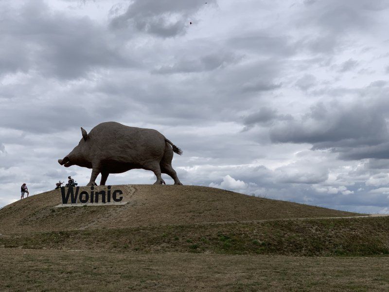
Woinic, Saulces-Monclin, Frankreich
A34 - Sortie 14, 08270 Saulces-Monclin, Frankreich
49° 35' 40.5" N 4° 30' 13.8" E
49.5945785 4.5038376
• Head west. Go for 67 m.
• Take the 2nd exit from roundabout toward Charleville-Mézières/Novion-Porcien. Go for 253 m.
• Continue toward A34. Go for 40 m.
• Take the 2nd exit from roundabout onto A34 toward Reims/Rethel. Go for 11.8 km.
• Keep left onto N51 toward Reims/Rethel/L'Étoile. Go for 17.1 km.
• Take ramp toward Juniville/Le Châtelet S/R./Bergnicourt. Go for 201 m.
• Turn right onto D925 toward Bergnicourt/Asfeld/Neufchâtel S/A. Go for 6.6 km.
• Turn left onto Grande Rue (D925). Go for 10.8 km.
• Turn right onto Rue du Faubourg de Reims (D966). Go for 1.1 km.
• Turn left onto Place du Colonel Driant (D925) toward A26/Menneville/Guignicourt. Go for 5.1 km.
• Take the 2nd exit from roundabout onto Rue Franklin Roosevelt (D925). Go for 3.8 km.
• Take ramp onto A26 (Autoroute des Anglais) toward Laon/Lille/Calais. Go for 73.4 km.
• Take the exit toward Rouen/Amiens/Péronne/A1 (Paris) onto A29. Go for 53.9 km.
• Take exit 52 toward Corbie/Villers-Bretonneux/Moreuil. Go for 283 m.
• Take the 1st exit from roundabout toward Corbie/Villers-Bretonneux/Moreuil. Go for 629 m.
• Take the 1st exit from roundabout onto D23. Go for 3.8 km.
• Turn right onto D76. Go for 1.1 km.
• Continue on Rue de Démuin (D76). Go for 1.8 km.
• Continue on Route d'Hangard (D76). Go for 619 m.
• Continue on D76. Go for 23 m.
• Continue on Rue d'Hangard (D76). Go for 97 m.
• Turn right onto Rue du Pont (D934). Go for 600 m.
• Turn left onto Rue de Berteaucourt (D76) toward Berteaucourt les Thennes. Go for 595 m.
• Continue on D76. Go for 318 m.
• Continue on Rue de la République (D76). Go for 380 m.
• Turn right onto Rue de la République (D76). Go for 179 m.
• Continue on Rue Jules Ferry (D76). Go for 693 m.
• Turn left onto Rue Jean Jaurès (D935). Go for 483 m.
• Turn right onto D54. Go for 1.0 km.
• Turn right onto D134. Go for 334 m.
• Turn right onto D134. Go for 564 m.
• Continue on Lieu-dit L'Enclos du Château (D134). Go for 129 m.
• Continue on Rue du 12ème Cuirassier (D134). Go for 197 m.
• Continue on Rue de Rouvrel (D134). Go for 45 m.
• Turn right onto Rue de Hailles. Go for 185 m.
• Arrive at Rue de Hailles.
☍
198,2 km
(2 hrs. 3 min.)
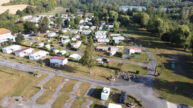
Camping La Vallée de l'Avre, Rue de Hailles, Moreuil, Frankreich
8 Rue de Hailles, 80110 Moreuil, Frankreich
49° 47' 34.1" N 2° 27' 15.7" E
49.7927923 2.4543621
• Head toward Ruelle de l'Église on Rue de Hailles. Go for 185 m.
• Turn left onto Rue de Rouvrel (D134). Go for 45 m.
• Continue on Rue du 12ème Cuirassier (D134). Go for 197 m.
• Continue on Lieu-dit L'Enclos du Château (D134). Go for 129 m.
• Continue on D134. Go for 564 m.
• Continue on Lieu-dit Le Bosquet du Hêtre (D134). Go for 121 m.
• Turn right toward D134. Go for 36 m.
• Turn left onto D54. Go for 1.3 km.
• Turn left onto Rue d'Amiens (D935). Go for 497 m.
• Turn right onto Rue Jules Ferry (D76). Go for 43 m.
• Turn left onto Rue Parmentier (D476). Go for 508 m.
• Continue on D476. Go for 1.4 km.
• Turn slightly right toward D934. Go for 122 m.
• Turn left onto D934. Go for 4.9 km.
• Take the 3rd exit from roundabout onto D934 toward A29/Amiens/Boves/Longueau. Go for 838 m.
• Take the 3rd exit from roundabout onto D934. Go for 1.0 km.
• Take ramp onto A29 toward Rouen/Calais. Go for 1.2 km.
• Take the left exit toward Rouen/Calais/Paris/Amiens-Centre/Amiens-Sud onto A29 (Viaduc de l'Avre). Go for 10.9 km.
• Take the exit toward Calais/Rouen/Amiens-Ouest onto A16 (L'Européenne). Go for 4.0 km.
• Take the exit toward Le Havre/Rouen/Dieppe/Poix de Picardie onto A29. Go for 59.5 km.
• Take the exit onto A28. Go for 20.7 km.
• Keep right onto A29 toward Le Havre/Caen. Go for 64.1 km.
• Take exit 7 toward Bolbec/Lillebonne/Étretat/Pont de Tancarville. Go for 1.2 km.
• Take the 4th exit from roundabout onto D910 toward Fécamp/Beuzeville la Grenier/Goderville/Étretat. Go for 3.2 km.
• Take the 2nd exit from roundabout onto Route de Goderville (D910). Go for 5.4 km.
• Take the 2nd exit from roundabout onto D910a. Go for 153 m.
• Continue on Rue Émile Bénard (D910a). Go for 716 m.
• Turn right onto Place Célestin Bellet. Go for 75 m.
• Turn right onto Place Godard des Vaux (D925 A). Go for 103 m.
• Continue on Rue Jean Prévost (D925 A). Go for 474 m.
• Turn left onto Rue des Prés (D72). Go for 747 m.
• Continue on Lieu-dit Ferme Duboc (D72). Go for 103 m.
• Continue on D72. Go for 81 m.
• Continue on Route de Goderville (D72). Go for 1.7 km.
• Continue on Route des Loges (D72). Go for 673 m.
• Continue on D72. Go for 2.4 km.
• Continue on Route des Loges (D72). Go for 3.2 km.
• Turn left onto Rue le Bourg (D940). Go for 6.2 km.
• Turn right onto Place Maurice Guillard (D39). Go for 57 m.
• Continue on Rue Monge (D39). Go for 89 m.
• Continue on Place Maréchal Foch (D39). Go for 23 m.
• Turn slightly left onto Rue Martin Vatinel (VC2). Go for 93 m.
• Turn left onto Rue Adolphe Boissaye. Go for 28 m.
• Continue on Rue A. Boissaye. Go for 80 m.
• Continue on Place du Général de Gaulle. Go for 47 m.
• Continue on Rue du Docteur de Miramont. Go for 126 m.
• Arrive at Rue du Docteur de Miramont.
☍
199,3 km
(2 hrs. 6 min.)
Day
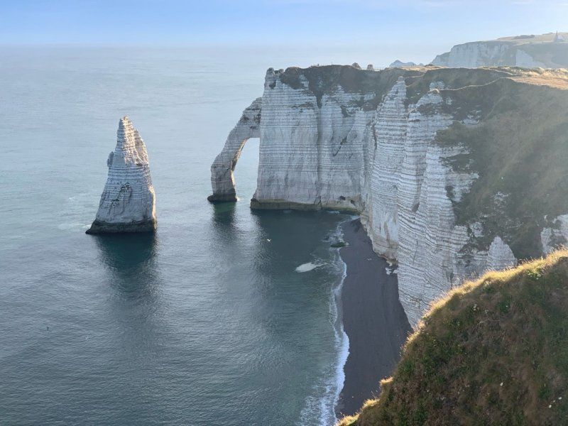
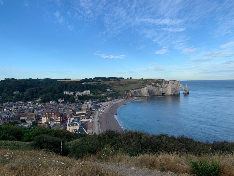
Falaise d'Étretat, Étretat, Frankreich
Étretat, Frankreich
49° 42' 26.3" N 0° 11' 36.9" E
49.7072999 0.1935822
• Head toward Rue de Traz Périer on Rue du Docteur de Miramont. Go for 126 m.
• Continue on Place du Général de Gaulle. Go for 47 m.
• Turn right onto Rue Alphonse Karr. Go for 26 m.
• Continue on Rue Alphonse Karr. Go for 107 m.
• Turn left onto Rue des Docteurs Fidelin (VC11). Go for 43 m.
• Turn right onto Rue Prosper Brindejont (VC4). Go for 134 m.
• Turn right onto Place Maurice Guillard (D39). Go for 17 m.
• Continue on Rue Guy de Maupassant (D39). Go for 1.0 km.
• Turn left. Go for 16 m.
• Arrive at your destination on the left.
☍
1,5 km
( 3 min.)
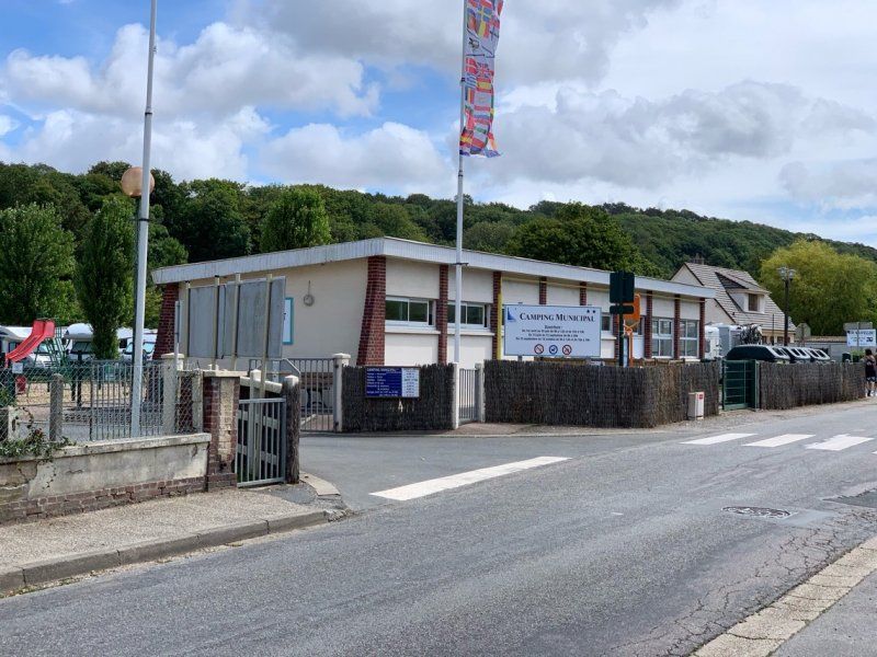
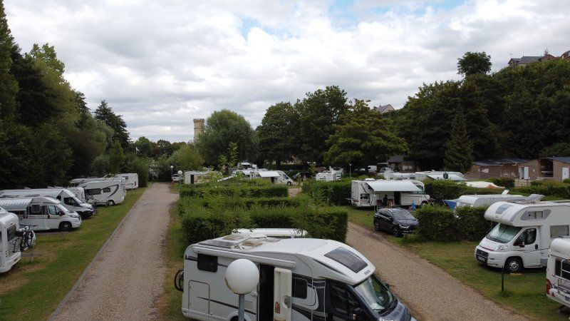
Camping Etretat, Rue Guy de Maupassant, Étretat, Frankreich
69 Rue Guy de Maupassant, 76790 Étretat, Frankreich
49° 42' 2.6" N 0° 12' 55.4" E
49.7007217 0.2153979
• Head toward Rue Guy de Maupassant. Go for 16 m.
• Turn left onto Rue Guy de Maupassant (D39). Go for 5.8 km.
• Take the 2nd exit from roundabout onto Chemin de Grande (D39). Go for 2.3 km.
• Turn right onto Route de Vergetot (D39). Go for 257 m.
• Continue on Place de Europe (D39). Go for 3.9 km.
• Turn right onto D925. Go for 2.6 km.
• Take the 2nd exit from roundabout onto Route du Havre (D925) toward Le Havre/Épouville/Montivilliers. Go for 2.7 km.
• Take the 3rd exit from roundabout onto D489 toward Le Havre/Harfleur/Montivilliers. Go for 9.3 km.
• Continue on D6382. Go for 775 m.
• Take ramp. Go for 185 m.
• Keep right toward Avenue de Verdun/D6015. Go for 551 m.
• Continue on Avenue de Verdun (D6015). Go for 243 m.
• Keep left toward A131/A29/Pont de Normandie/Port 1000-3000/Port 4000-6000. Go for 210 m.
• Continue on Boulevard Jules Durand. Go for 214 m.
• Keep left toward D6382/A131-A29/Pont de Normandie. Go for 1.2 km.
• Take ramp onto N282. Go for 1.1 km.
• Continue on A131. Go for 1.2 km.
• Take the exit toward Caen/Port du Havre/Pont de Normandie onto A29. Go for 3.4 km.
• Continue on N1029. Go for 7.1 km.
• Take ramp toward Honfleur. Go for 429 m.
• Take the 1st exit from roundabout onto D580 toward Caen/Trouville/Deauville/Honfleur. Go for 323 m.
• Pass 2 roundabouts and continue on D580. Go for 981 m.
• Take the 3rd exit from roundabout onto Cours Jean de Vienne (D580) toward Honfleur. Go for 768 m.
• Take the 2nd exit from Rond-Point du Port roundabout onto Cours Jean de Vienne (D580). Go for 388 m.
• Take the 3rd exit from Rond-Point Carnot roundabout onto Rue des Vases (D580). Go for 390 m.
• Take the 4th exit from Rond-Point de la Tour roundabout onto Quai Lepaulmier (D580). Go for 156 m.
• Take the 1st exit from Place de la Porte de Rouen roundabout onto Place de la Porte de Rouen (D580). Go for 148 m.
• Turn left onto Rue de la République (D579 A). Go for 21 m.
• Turn left onto Rue de la Chaussée. Go for 101 m.
• Arrive at Rue de la Chaussée. Your destination is on the right.
☍
46,8 km
( 43 min.)
Day
Honfleur, Frankreich
2 rue Alphonse Allais
14600 Honfleur
France
49° 25' 7.5" N 0° 13' 59.7" E
49.4187620 0.2332620
• Head toward Rue Montpensier on Rue de la Chaussée. Go for 43 m.
• Turn right onto Rue Paul et Charles Bréard. Go for 66 m.
• Continue on Rue des Buttes. Go for 157 m.
• Turn right onto Rue Jean Denis. Go for 64 m.
• Turn right onto Place Albert Sorel. Go for 54 m.
• Turn left onto Place Albert Sorel (D579 A). Go for 552 m.
• Take the 1st exit from roundabout onto Cours Albert Manuel (D579 A). Go for 2.1 km.
• Take the 3rd exit from roundabout onto Avenue Charles Houssaye (D579 A). Go for 3.3 km.
• Turn slightly right onto Route de Honfleur (D579 A). Go for 8.6 km.
• Take the 2nd exit from roundabout onto Route de Honfleur (D579) toward Caen/Paris/Lisieux. Go for 170 m.
• Take the 1st exit from roundabout onto Route de Honfleur (D579) toward Pont-l'Évêque/Rouen/Caen/Pont-l'Évêque-Centre. Go for 622 m.
• Turn right onto Route de Trouville (D677) toward St Martin aux Chartrains. Go for 57 m.
• Turn left. Go for 103 m.
• Arrive at your destination on the left.
☍
15,9 km
( 18 min.)
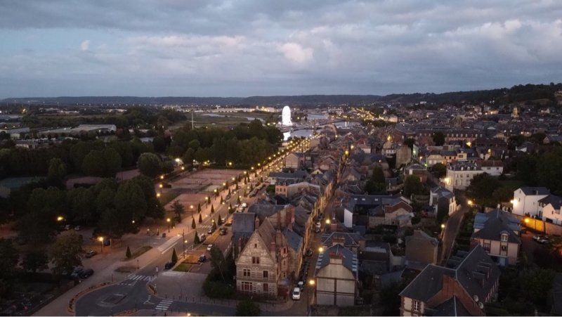
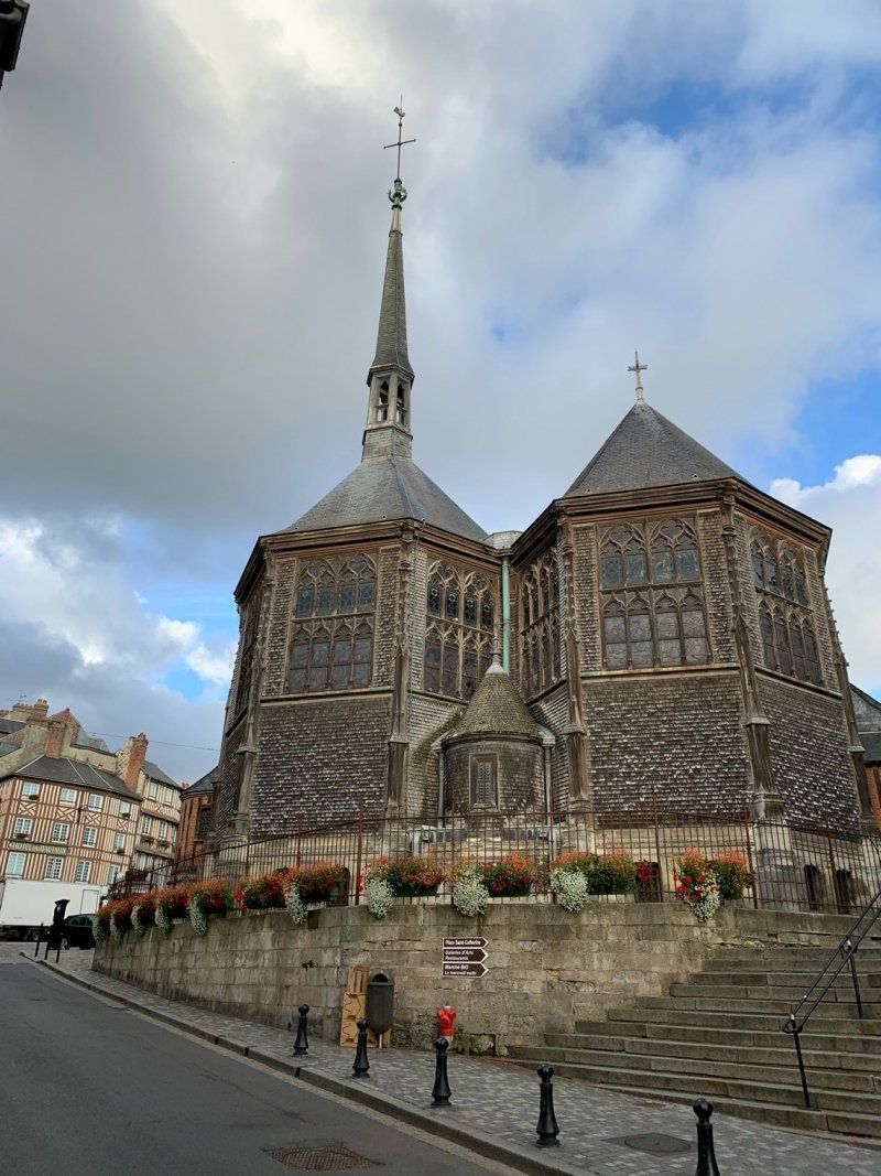
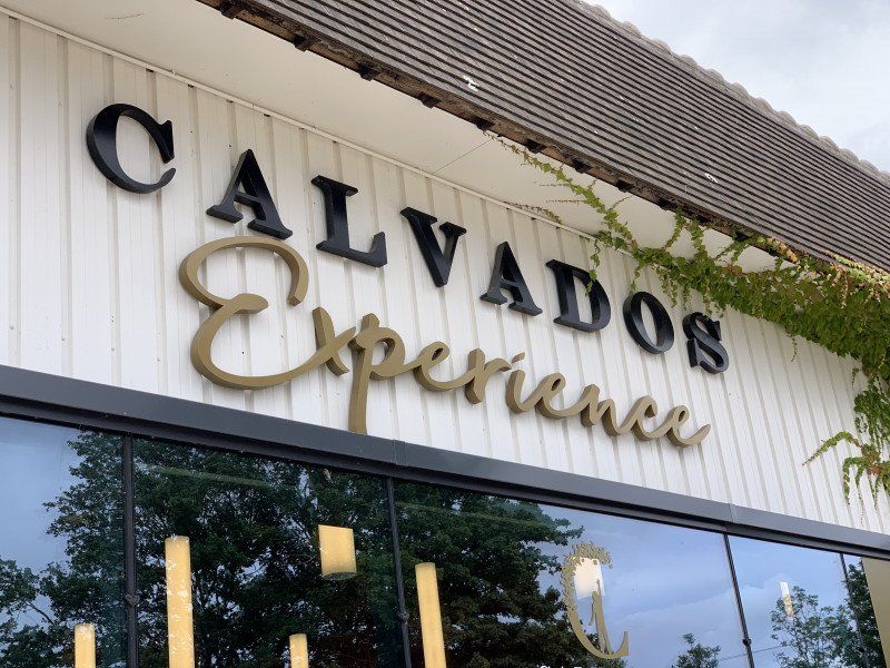
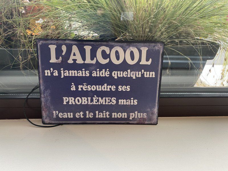
CALVADOS PÈRE MAGLOIRE L'EXPERIENCE, Route de Trouville, Pont-l'Évêque, Frankreich
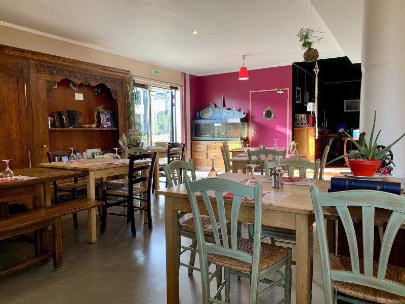
A somewhat different museum about Calvados, which is also very interesting and educational for children.
Route de Trouville, 14130 Pont-l'Évêque, Frankreich
49° 17' 35.2" N 0° 11' 14.8" E
49.2931222 0.1874576
• Head southeast.
• Turn left toward Route de Trouville/D677. Go for 239 m.
• Turn right onto Route de Trouville (D677). Go for 62 m.
• Turn left onto Route de Honfleur (D579). Go for 551 m.
• Continue toward Caen/Rouen/Paris/Lisieux/Pont-l'Évêque-Z.A. Go for 31 m.
• Take the 1st exit from roundabout onto A132 toward Caen/Rouen/Paris/Lisieux/Pont-l'Évêque-Z.A. Go for 841 m.
• Keep left onto A132 toward Lisieux/Pont-l'Évêque-Z.A. Go for 850 m.
• Continue on D579. Go for 4.4 km.
• Take the 2nd exit from roundabout onto Lieu-dit La Forge (D579) toward Lisieux/Le Breuil en Auge. Go for 2.5 km.
• Take the 1st exit from roundabout onto Domaine du Breuil (D264) toward Le Torquesne/Coquainvilliers. Go for 80 m.
• Turn right onto Domaine du Breuil. Go for 88 m.
• Continue on Lieu-dit Château du Breuil. Go for 110 m.
• Arrive at Lieu-dit Château du Breuil. Your destination is on the right.
☍
9,8 km
( 9 min.)
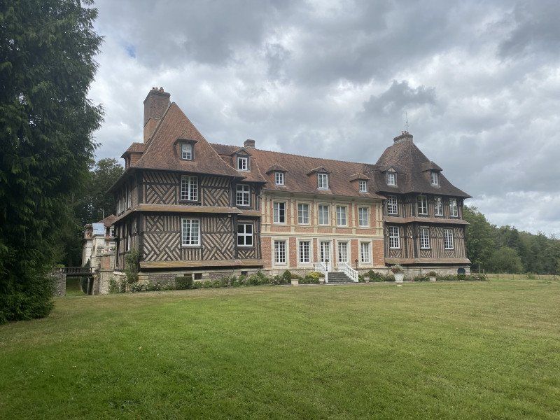
Château du Breuil, Les Jourdains, Le Breuil-en-Auge, Frankreich
Not as interesting as CALVADOS L'EXPERIENCE but still worth a detour, especially for Calvados lovers and botanists.
Le, Les Jourdains, 14130 Le Breuil-en-Auge, Frankreich
49° 13' 50.2" N 0° 12' 53.9" E
49.2306213 0.2149706
• Head east on Lieu-dit Château du Breuil. Go for 110 m.
• Continue on Domaine du Breuil. Go for 88 m.
• Turn left onto Domaine du Breuil (D264). Go for 46 m.
• Take the 3rd exit from roundabout onto D579 toward A13/Fierville les Parcs/Pont-l'Évêque/Blangy le Château. Go for 2.6 km.
• Take the 3rd exit from roundabout onto D579 toward Pont-l'Évêque. Go for 4.5 km.
• Continue on A132. Go for 259 m.
• Take the exit toward Caen onto A13 (Autoroute de Normandie). Go for 21.9 km.
• Take exit 30 toward Houlgate/Cabourg/Dives S/Mer/Dozulé. Go for 1.7 km.
• Keep right onto D400 toward Houlgate/Cabourg/Dives S/Mer. Go for 3.4 km.
• Take the 3rd exit from roundabout onto D27. Go for 4.2 km.
• Take the 2nd exit from roundabout onto D513. Go for 6.1 km.
• Take the 1st exit from roundabout onto Route de Cabourg (D224). Go for 1.4 km.
• Continue on Rue du Général de Gaulle (D37). Go for 1.3 km.
• Take the 2nd exit from roundabout onto D37. Go for 623 m.
• Take the 2nd exit from roundabout onto Route de Cabourg (D514). Go for 316 m.
• Arrive at Route de Cabourg (D514). Your destination is on the left.
☍
48,5 km
( 36 min.)
Day
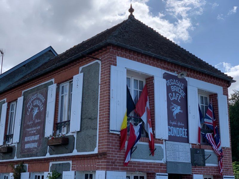
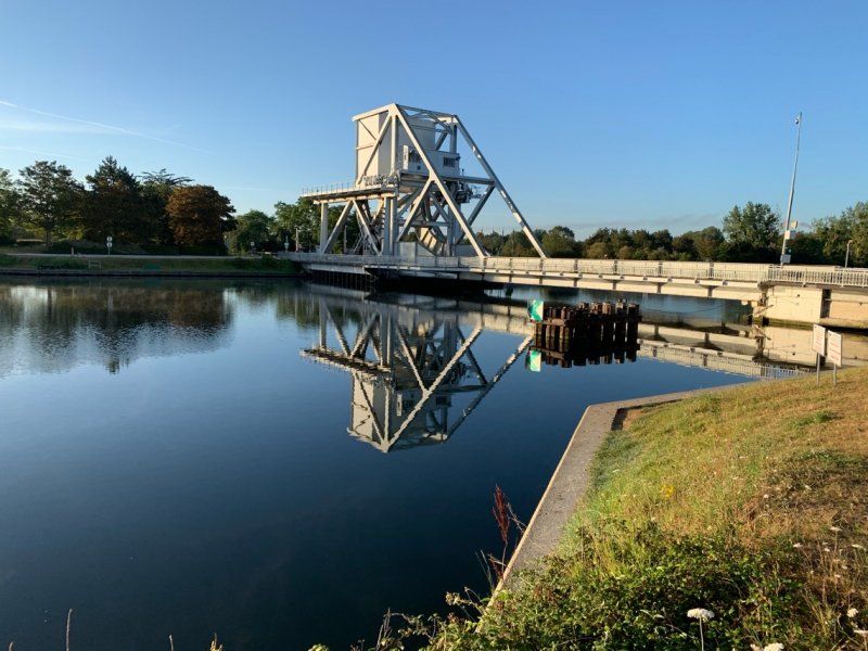
Pegasus Bridge, Ranville, Frankreich
14860 Ranville, Frankreich
49° 14' 24.8" N 0° 16' 0.5" W
49.2402170 -0.2668150
• Head toward Chemin de Halage on Route de Cabourg (D514). Go for 177 m.
• Pass 2 roundabouts and continue on D514. Go for 1.2 km.
• Take ramp onto D514 toward Ouistreham Car Ferry/Douvres la Délivrande/Zone d'Activités de Bénouville. Go for 2.8 km.
• Take the 2nd exit from roundabout onto Avenue du Grand-Large (D84) toward Ouistreham Car Ferry/Le Port/Port Ouistreham Car Ferry Gare Maritime/Plage de Riva-Bella. Go for 835 m.
• Take the 3rd exit from roundabout onto Avenue du Grand-Large (D84). Go for 1.0 km.
• Turn right onto Place du Général de Gaulle toward Stade Kieffer. Go for 159 m.
• Turn left onto Place du Général de Gaulle toward Courseulles S/Mer. Go for 44 m.
• Turn right onto Avenue Général Leclerc (D84) toward Courseulles S/Mer. Go for 228 m.
• Turn right. Go for 8 m.
• Turn right. Go for 62 m.
• Arrive at your destination on the right.
☍
6,5 km
( 8 min.)
Ouistreham Riva Bella Gym, Avenue Général Leclerc, Ouistreham, Frankreich
The campsite and the village is not really worth mentioning.
85 Avenue Général Leclerc, 14150 Ouistreham, Frankreich
49° 16' 55.2" N 0° 15' 10.4" W
49.2819950 -0.2529027
• Head southwest. Go for 52 m.
• Turn right toward Avenue Général Leclerc/D84. Go for 8 m.
• Turn right onto Avenue Général Leclerc (D84). Go for 608 m.
• Continue on Route de Lion (D514). Go for 3.4 km.
• Turn left onto Avenue du 6 Juin (D60 B). Go for 1.0 km.
• Turn right onto Rue de la Canardière (D60 B). Go for 339 m.
• Turn left onto D60. Go for 1.5 km.
• Turn right onto D35. Go for 1.8 km.
• Turn left onto Rue de Caen (D221). Go for 876 m.
• Continue on D221. Go for 1.7 km.
• Take the 2nd exit from roundabout onto D404. Go for 2.4 km.
• Take the 2nd exit from roundabout onto D404. Go for 2.3 km.
• Continue on D79. Go for 718 m.
• Take the 3rd exit from roundabout onto D35. Go for 2.0 km.
• Take the 3rd exit from roundabout onto Grande Rue (D35). Go for 4.8 km.
• Take the 2nd exit from roundabout onto Route de Courseulles (D12). Go for 1.2 km.
• Turn right onto D65. Go for 2.9 km.
• Take the 3rd exit from roundabout onto D65. Go for 5.6 km.
• Continue on D514. Go for 312 m.
• Continue on Rue Maurice Lithare. Go for 89 m.
• Turn right onto Rue Colonel René Michel. Go for 90 m.
• Arrive at Rue Colonel René Michel. Your destination is on the left.
☍
33,9 km
( 41 min.)
Day
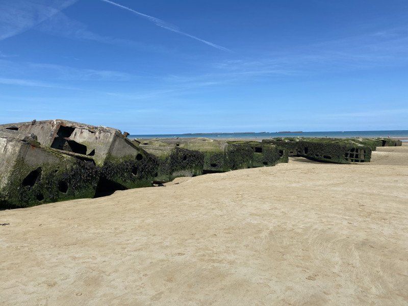
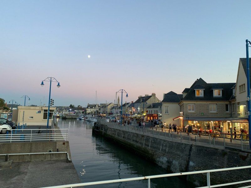
Arromanches-les-Bains, Frankreich
49° 20' 20.5" N 0° 37' 20.7" W
49.3390210 -0.6224150
• Head toward Rue du Maréchal Joffre on Rue Colonel René Michel. Go for 107 m.
• Turn right onto Place du 6 Juin 1944 (D514). Go for 29 m.
• Turn right onto Rue du Petit Fontaine. Go for 174 m.
• Turn left onto Rue F. Jourdan de la Passardière (D514). Go for 175 m.
• Continue on Rue Lucien Joly. Go for 12 m.
• Arrive at Rue Lucien Joly. Your destination is on the left.
☍
0,5 km
( 1 min.)
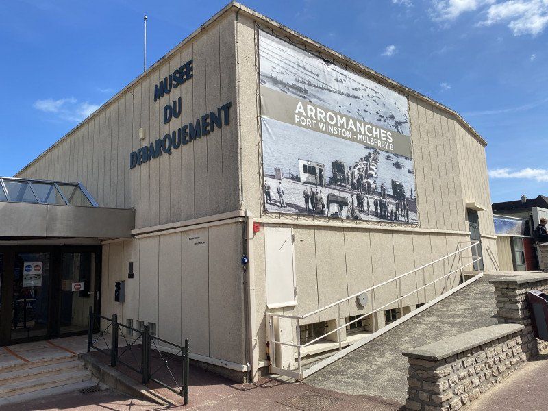
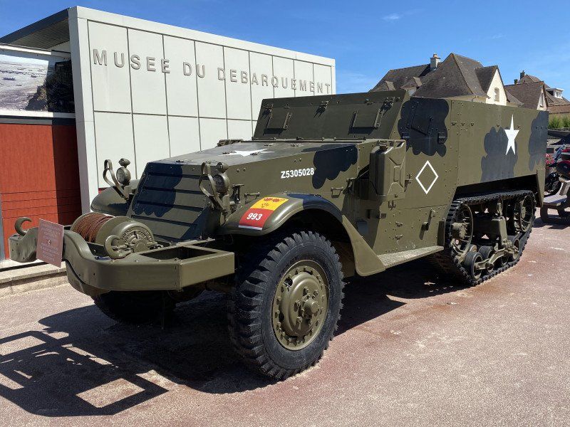
Musée du Débarquement, Arromanches-les-Bains, Frankreich
A MUST for anyone interested in history!
Place du 6 Juin, 14117 Arromanches-les-Bains, Frankreich
49° 20' 24.7" N 0° 37' 13" W
49.3401858 -0.6202649
• Head toward Rue F. Jourdan de la Passardière on Rue Lucien Joly. Go for 12 m.
• Turn right onto Place du 6 Juin 1944 (D514). Go for 128 m.
• Turn left onto Rue du Petit Fontaine. Go for 254 m.
• Turn right onto Rue Maurice Lithare. Go for 89 m.
• Continue on Rue d'Instow. Go for 126 m.
• Turn left onto Boulevard Gilbert Longuet. Go for 72 m.
• Turn right onto Avenue de Verdun (D87). Go for 455 m.
• Turn left onto Lieu-dit La Brèche (D514). Go for 620 m.
• Take the 2nd exit from roundabout onto D516. Go for 5.5 km.
• Turn right onto D153. Go for 1.1 km.
• Continue on Lieu-dit Hameau le Hutrel (D153). Go for 305 m.
• Turn left onto D104. Go for 95 m.
• Turn right onto D153. Go for 99 m.
• Continue on Hameau de Glatigny (D153). Go for 194 m.
• Continue on Lieu-dit Glatigny (D153). Go for 83 m.
• Continue on Lieu-dit Glatigny (D169). Go for 83 m.
• Continue on Lieu-dit Saint-Eustache (D169). Go for 1.1 km.
• Continue on D169. Go for 674 m.
• Turn right onto Route de Port-en-Bessin (D6). Go for 5.0 km.
• Take the 2nd exit from Rond-Point de Montgomery roundabout onto Rue de Bayeux. Go for 610 m.
• Turn left onto Avenue du Maréchal de Tourville (D514). Go for 1.3 km.
• Turn right onto Chemin du Sémaphore. Go for 233 m.
• Turn right onto Allée du Tee. Go for 21 m.
• Arrive at Allée du Tee. Your destination is on the right.
☍
18,1 km
( 23 min.)
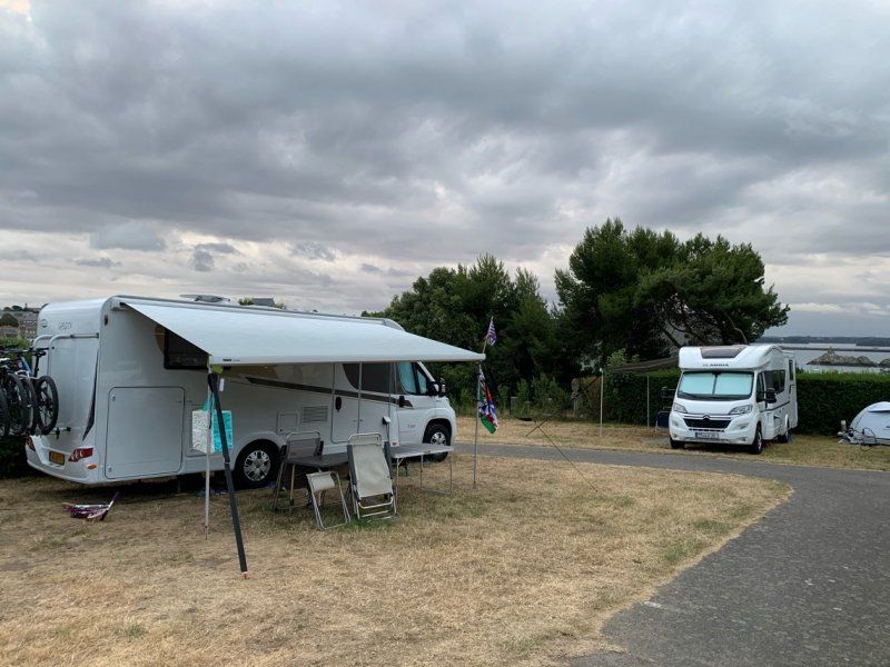
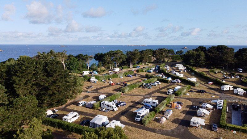
Camping Port' Land
A beautifully landscaped campsite above Port-en-Bessin. You can easily reach the village on foot, only the way back has a small incline (18%) :-)
chemin du castel, 14520, Port en Bessin, Frankreich
49° 20' 46.7" N 0° 46' 23.5" W
49.3463000 -0.7732000
• Head toward Chemin du Sémaphore on Allée du Tee. Go for 21 m.
• Turn left onto Chemin du Sémaphore. Go for 233 m.
• Continue on Rue du Bourg. Go for 429 m.
• Turn right onto Rue Abbé Mazurier. Go for 394 m.
• Turn left onto Route du Mont Onfroy. Go for 126 m.
• Arrive at Route du Mont Onfroy. Your destination is on the left.
☍
1,2 km
( 3 min.)
Port-en-Bessin-Huppain, Frankreich
14520 Port-en-Bessin-Huppain, Frankreich
49° 20' 14.5" N 0° 46' 19.1" W
49.3373658 -0.7719714
• Head toward Rue de Villiers on Route du Mont Onfroy. Go for 126 m.
• Turn right onto Rue Abbé Mazurier. Go for 394 m.
• Turn left onto Rue du Bourg. Go for 429 m.
• Continue on Chemin du Sémaphore. Go for 233 m.
• Turn right onto Allée du Tee. Go for 21 m.
• Arrive at Allée du Tee. Your destination is on the right.
☍
1,2 km
( 3 min.)
Day
Camping Port' Land
chemin du castel, 14520, Port en Bessin, Frankreich
49° 20' 46.7" N 0° 46' 23.5" W
49.3463000 -0.7732000
• Head toward Chemin du Sémaphore on Allée du Tee. Go for 21 m.
• Turn left onto Chemin du Sémaphore. Go for 233 m.
• Turn right onto Route de Grandcamp (D514). Go for 6.5 km.
• Take the 2nd exit from roundabout onto Route d'Omaha Beach (D514). Go for 2.4 km.
• Take the 1st exit from roundabout onto Avenue de la Libération (D517). Go for 1.3 km.
• Take the 2nd exit from Avenue de la Libération roundabout onto Rue Bernard Anquetil. Go for 696 m.
• Arrive at Rue Bernard Anquetil.
☍
11,1 km
( 17 min.)
Day
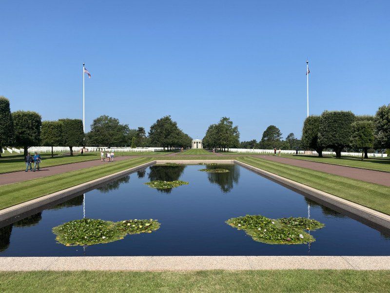
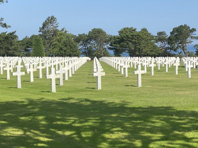
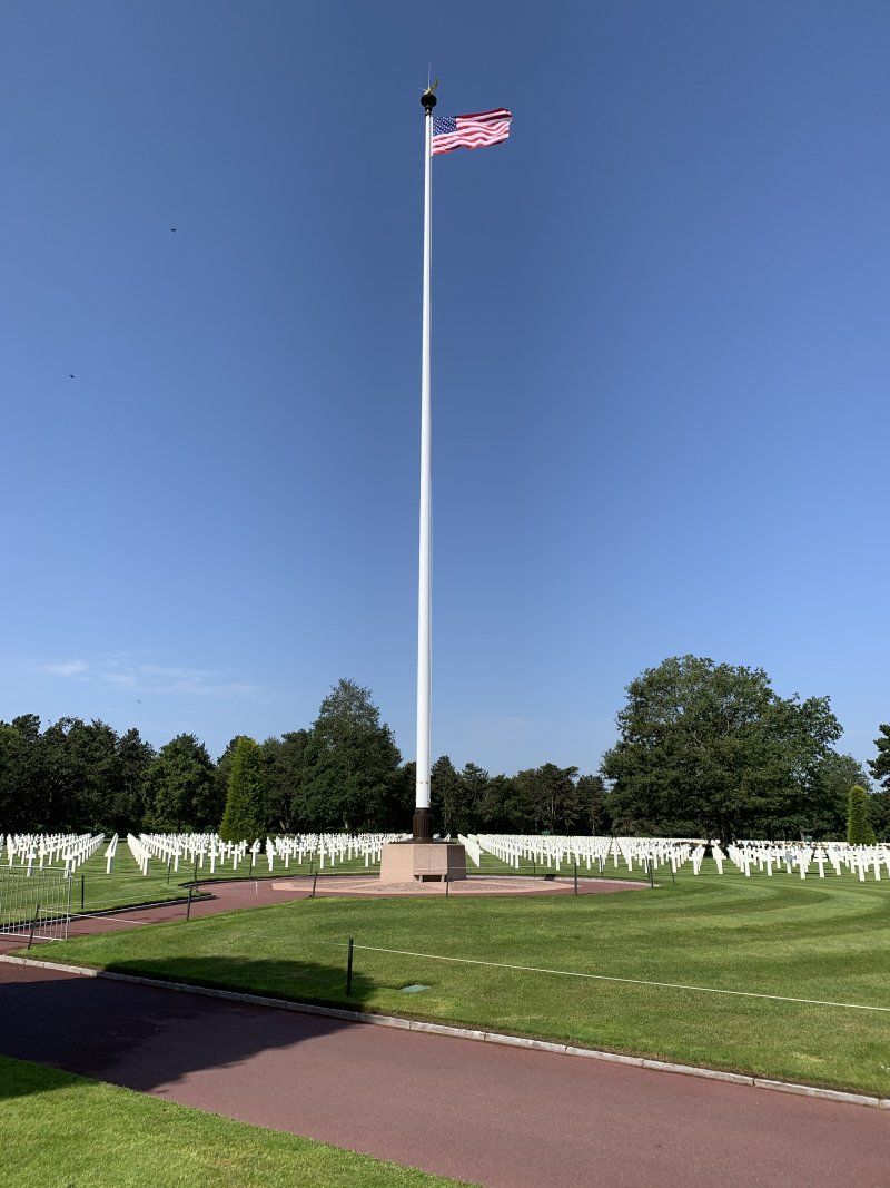
Omaha Beach, Frankreich
49° 22' 10.9" N 0° 52' 15.9" W
49.3696815 -0.8710842
• Head toward Rue des Costils on Rue Bernard Anquetil. Go for 663 m.
• Take the 1st exit from Avenue de la Libération roundabout onto Avenue de la Libération (D517). Go for 36 m.
• Turn left onto Rue du 116ème Régiment U.S.A. Go for 71 m.
• Turn left onto Rue du 6 Juin 1944. Go for 264 m.
• Continue on Rue du Hamel aux Prêtres. Go for 1.4 km.
• Turn right onto Rue Pavée (D514). Go for 280 m.
• Turn left onto Route de Formigny (D30). Go for 600 m.
• Continue on Lieu-dit L'Ormel (D30). Go for 27 m.
• Continue on D30. Go for 251 m.
• Continue on Lieu-dit Les Isles (D30). Go for 95 m.
• Continue on D30. Go for 2.3 km.
• Continue on Rue Capet (D30). Go for 1.3 km.
• Turn right onto Lieu-dit Formigny (D517). Go for 598 m.
• Turn right onto Lieu-dit Formigny (D613). Go for 1.5 km.
• Turn left and take ramp onto N13 toward Cherbourg/Grandchamp-Maisy/Isigny sur Mer/La Cambe. Go for 20.8 km.
• Take ramp onto N174 toward Rennes/Saint Lô/St Jean de Daye. Go for 48.9 km.
• Take the 1st exit from roundabout onto A84 toward Rennes/Villedieu les Poêles. Go for 44.7 km.
• Continue on N175. Go for 10.6 km.
• Take ramp onto N175 toward St Brieuc/St Malo/Le Mont-St Michel/Pontorson. Go for 2.1 km.
• Take ramp onto Lieu-dit La Chaussée (D43) toward Courtils. Go for 7.1 km.
• Continue on D275. Go for 4.6 km.
• Take the 2nd exit from roundabout onto D776. Go for 983 m.
• Turn right onto Route du Mont-Saint-Michel. Go for 256 m.
• Turn right. Go for 144 m.
• Turn left toward Lieu-dit Le Bas Pays. Go for 190 m.
• Turn left onto Lieu-dit Le Bas Pays. Go for 165 m.
• Turn right onto Route du Mont-Saint-Michel. Go for 195 m.
• Continue on Route du Mont-Saint-Michel. Go for 340 m.
• Arrive at Route du Mont-Saint-Michel.
☍
150,3 km
(1 hrs. 40 min.)
La Caserne Ardevon, Pontorson, Frankreich
La Caserne Ardevon, 50170 Pontorson, Frankreich
48° 37' 0.7" N 1° 30' 38.9" W
48.6168633 -1.5107949
• Head north on Route du Mont-Saint-Michel. Go for 2.2 km.
• Turn left onto Montée aux Poulains. Go for 261 m.
• Arrive at Montée aux Poulains. Your destination is on the left.
☍
2,4 km
( 7 min.)
Day
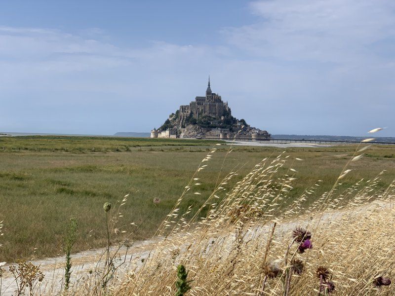
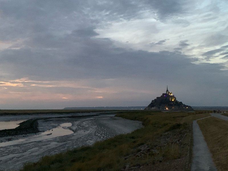
Mont Saint-Michel, Frankreich
50170 Le Mont-Saint-Michel, Frankreich
48° 38' 9.8" N 1° 30' 41.2" W
48.6360630 -1.5114570
• Head west on Montée aux Poulains. Go for 261 m.
• Turn left. Go for 12 m.
• Arrive at your destination on the right.
☍
0,3 km
( 1 min.)
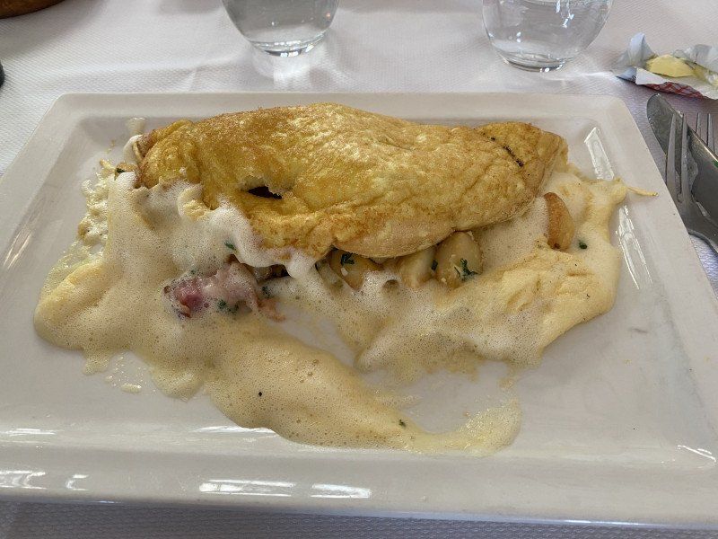
Mère Poulard, Grande Rue, Le Mont-Saint-Michel, Frankreich
The most expensive omelette we have ever eaten seems to be a hit, many celebrities have been there and seem to be regulars there.
As I said the most expensive but not the best omelet.
BP 18 Grande Rue, 50170 Le Mont-Saint-Michel, Frankreich
48° 38' 6.4" N 1° 30' 39.4" W
48.6351066 -1.5109527
• Head toward Montée aux Poulains. Go for 116 m.
• Continue on Route du Mont-Saint-Michel. Go for 2.1 km.
• Arrive at Route du Mont-Saint-Michel (D976).
☍
2,2 km
( 5 min.)
La Caserne Ardevon, Pontorson, Frankreich
La Caserne Ardevon, 50170 Pontorson, Frankreich
48° 37' 0.7" N 1° 30' 38.9" W
48.6168633 -1.5107949
• Head south on Route du Mont-Saint-Michel (D976). Go for 560 m.
• Turn left onto Lieu-dit Le Bas Pays. Go for 178 m.
• Turn sharp right toward D776. Go for 443 m.
• Turn right onto D776. Go for 5.9 km.
• Take the 1st exit from roundabout onto Boulevard du Général Patton (D19). Go for 624 m.
• Take the 1st exit from Rue Couesnon roundabout onto Rue Couesnon (D776) toward St Malo/Dinan/Pleine-Fougères/Dol de B. Go for 250 m.
• Take the 1st exit from roundabout onto Route de Saint-Georges (D997). Go for 1.4 km.
• Take the 1st exit from roundabout onto D797 toward St Malo/Dinan/Dol de Bgne/St Georges de Ggne/Roz S/Couesnon/Cherrueix. Go for 317 m.
• Take the 2nd exit from roundabout onto N176 toward St Malo/Dinan/Dol de Bgne. Go for 28.8 km.
• Take ramp onto D137 toward St Malo/Châteauneuf d'I. et V./Barrage de la Rance. Go for 10.3 km.
• Keep left onto D137 toward Saint-Malo Par Saint-Servan/D168/Dinard/Aéroport Pleurtuit/Barrage de la Rance. Go for 260 m.
• Keep left onto Rue du Général Patton (D137) toward Saint-Malo Par Saint-Servan. Go for 152 m.
• Pass 2 roundabouts and continue on Rue du Général Patton. Go for 845 m.
• Continue on Rue de la Balue. Go for 280 m.
• Take the 1st exit from roundabout onto Rue de la Balue. Go for 296 m.
• Take the 3rd exit from Rond-Point du Mouchoir Vert roundabout onto Boulevard Douville toward St Servan/Hôpital le Rosais/St Servan-Centre. Go for 501 m.
• Continue on Rue Ville Pépin. Go for 192 m.
• Continue on Rue Ville Pépin. Go for 57 m.
• Turn left onto Place du Maréchal Leclerc. Go for 13 m.
• Turn right onto Boulevard Porée. Go for 184 m.
• Turn left onto Boulevard Gouazon. Go for 192 m.
• Turn right onto Rue Jean XXIII. Go for 127 m.
• Continue on Rue de la Fontaine. Go for 57 m.
• Turn right onto Rue Duport-Dutertre. Go for 160 m.
• Continue on Rue Ernest Lamort. Go for 108 m.
• Continue on Rue de la Cité. Go for 137 m.
• Turn slightly left onto Rue de la Cité. Go for 151 m.
• Continue on Place Saint-Pierre. Go for 13 m.
• Turn left onto Allée Gaston Buy. Go for 6 m.
• Turn slightly right onto Allée Gaston Buy. Go for 119 m.
• Arrive at Allée Gaston Buy. Your destination is on the left.
☍
52,6 km
( 45 min.)
Day
Camping de la Cité d'Alet, Allée Gaston Buy, Saint-Malo, Frankreich
Allée Gaston Buy, 35400 Saint-Malo, Frankreich
48° 38' 9.2" N 2° 1' 41.3" W
48.6358920 -2.0281326
• Head toward Rue des Glacis on Allée Gaston Buy. Go for 119 m.
• Turn right onto Place Saint-Pierre. Go for 33 m.
• Turn left onto Place Saint-Pierre. Go for 17 m.
• Continue on Rue d'Alet. Go for 120 m.
• Turn left onto Quai Sébastopol. Go for 44 m.
• Keep right onto Esplanade du Commandant Yves Menguy. Go for 144 m.
• Continue on Rue Amiral Épron. Go for 43 m.
• Turn slightly right onto Rue des Hauts-Sablons. Go for 130 m.
• Continue on Place Monseigneur Duchesne. Go for 126 m.
• Continue on Rue des Bas-Sablons. Go for 217 m.
• Continue on Rue de Gaspé. Go for 230 m.
• Take the 4th exit from roundabout onto Quai du Naye (D126) toward Port Terminal Ferry du Naye/Gare Maritime de la Bourse. Go for 464 m.
• Pass 2 roundabouts and continue on Quai Saint-Louis (D126). Go for 676 m.
• Turn left onto Porte Saint-Louis. Go for 17 m.
• Continue on Rue de Toulouse. Go for 47 m.
• Turn right onto Rue d'Asfeld. Go for 64 m.
• Continue on Rue des Cordiers. Go for 121 m.
• Turn left onto Rue du Puits aux Braies. Go for 61 m.
• Turn right onto Rue des Marins. Go for 52 m.
• Continue on Rue des Merciers. Go for 41 m.
• Continue on Place de la Poissonnerie. Go for 38 m.
• Turn slightly right onto Rue Sainte-Marguerite. Go for 19 m.
• Turn right onto Rue Sainte-Barbe. Go for 46 m.
• Turn slightly right onto Rue Jacques Cartier. Go for 21 m.
• Arrive at Rue Jacques Cartier. Your destination is on the right.
☍
2,9 km
( 8 min.)
Le Tourne Pierre, Rue Jacques Cartier, Saint-Malo, Frankreich
A coincidence that can only be recommended.
4 Rue Jacques Cartier, 35400 Saint-Malo, Frankreich
48° 38' 57.7" N 2° 1' 25.9" W
48.6493711 -2.0238645
• Head south on Rue Jacques Cartier. Go for 43 m.
• Keep right onto Place du Poids du Roi. Go for 37 m.
• Turn right onto Rue du Puits aux Braies. Go for 61 m.
• Turn left onto Rue Boursaint. Go for 20 m.
• Turn slightly left onto Rue de la Herse. Go for 116 m.
• Turn right onto Rue des Forgeurs. Go for 60 m.
• Continue on Rue Saint-François. Go for 58 m.
• Turn right onto Rue Robert Surcouf. Go for 21 m.
• Turn left onto Rue Sainte-Catherine. Go for 32 m.
• Continue on Place Brevet. Go for 28 m.
• Continue on Rue Saint-Sauveur. Go for 71 m.
• Turn right onto Rue des Bouchers. Go for 75 m.
• Continue on Rue de la Crosse. Go for 113 m.
• Continue on Rue Sainte-Anne. Go for 80 m.
• Continue on Rue Grout de Saint-Georges. Go for 48 m.
• Turn right onto Rue Toullier. Go for 34 m.
• Turn right onto Rue Toullier. Go for 43 m.
• Turn left onto Place Gasnier-Duparc. Go for 51 m.
• Turn right onto Place Jean de Châtillon. Go for 43 m.
• Turn left onto Rue Guillaume Le Gouverneur. Go for 22 m.
• Arrive at Rue Guillaume Le Gouverneur. Your destination is on the left.
☍
1,1 km
( 3 min.)
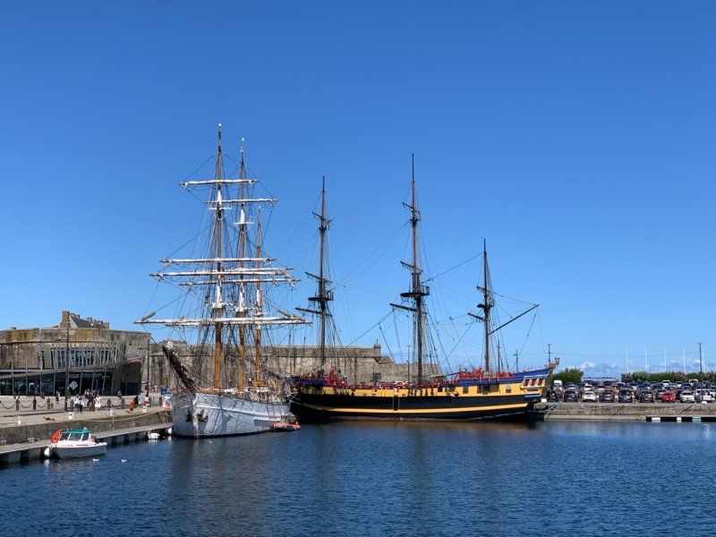
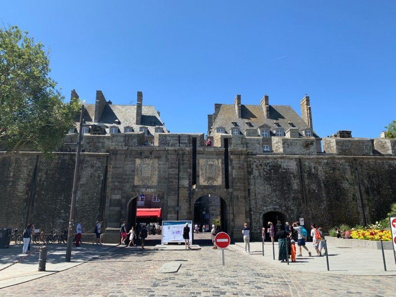
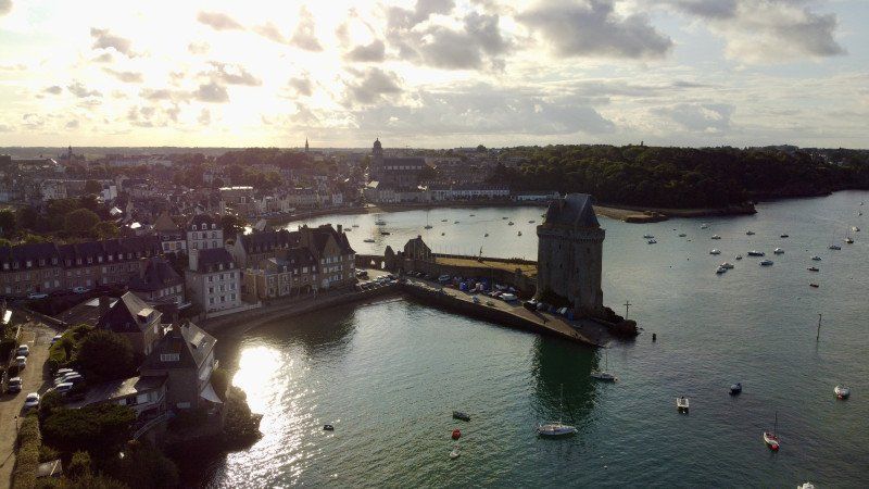
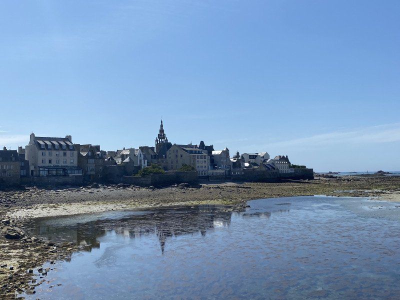
St Malo, Frankreich
Saint-Malo, Frankreich
48° 38' 57.6" N 2° 1' 32.4" W
48.6493370 -2.0256740
• Head toward Place Jean de Châtillon on Rue Guillaume Le Gouverneur. Go for 22 m.
• Turn left onto Rue du Pourpris. Go for 43 m.
• Continue on Rue Broussais. Go for 121 m.
• Continue on Rue de Dinan. Go for 177 m.
• Continue on Porte de Dinan. Go for 25 m.
• Turn left onto Esplanade de la Bourse. Go for 38 m.
• Turn right onto Esplanade de la Bourse. Go for 141 m.
• Take the 2nd exit from Rond-Point de l'Île Maurice roundabout onto Chaussée Éric Tabarly (D126). Go for 529 m.
• Take the 3rd exit from Rond-Point du Naye roundabout onto Quai de Trichet (D126) toward Les Sablons/La Gare. Go for 467 m.
• Take the 4th exit from roundabout onto Quai de Trichet (D126) toward Barrage de la Rance. Go for 455 m.
• Take the 2nd exit from Giratoire des Quatre Pavillons roundabout onto Rue des Grèves de Chasles (D126) toward Marville/Paramé. Go for 152 m.
• Take the 1st exit from roundabout onto Boulevard des Talards toward Bellevue. Go for 212 m.
• Continue on Rue de la Marne. Go for 959 m.
• Take the 3rd exit from Rond-Point du Mouchoir Vert roundabout onto Rue de la Balue toward Dol-de-Bretagne/Barrage de la Rance/Lorette/La Madeleine. Go for 333 m.
• Take the 2nd exit from roundabout onto Rue de la Balue. Go for 316 m.
• Continue on Rue du Général Patton. Go for 416 m.
• Take the 2nd exit from roundabout onto Rue du Général Patton. Go for 348 m.
• Take the 3rd exit from Rond-Point René Cassin roundabout onto Rue du Général Patton (D137). Go for 10.1 km.
• Take ramp onto N176 toward St Brieuc/Dinan/Plouër S/Rance. Go for 44.2 km.
• Take ramp onto N12. Go for 28.2 km.
• Keep left onto N12 toward St Brieuc-Centre/Brest/Plérin/Port de St Brieuc-le Légué. Go for 974 m.
• Keep left onto Avenue de France (N12) toward Lannion/Morlaix/Brest/Plérin/Aéroport St Brieuc-Armor. Go for 38.3 km.
• Take ramp toward Kernilien/Lannion/Tréguier/Bégard. Go for 249 m.
• Take the 2nd exit from roundabout onto D767 toward Lannion/Perros-Guirec/Bégard/Tréguier. Go for 25.8 km.
• Take the 2nd exit from Rond-Point Kroafhent-Tro Boutilh roundabout onto D767 toward Tréguier/Perros-Guirec/Trégastel. Go for 1.3 km.
• Take the 3rd exit from roundabout onto D767. Go for 2.0 km.
• Pass 2 roundabouts and continue on D767. Go for 1.7 km.
• Take the 2nd exit from Rond-Point de Kurguilh roundabout onto Route de Perros (D788). Go for 866 m.
• Pass 2 roundabouts and continue on D788. Go for 2.9 km.
• Take the 1st exit from Pont Couennec roundabout onto Route de Perros (D6). Go for 1.1 km.
• Turn left. Go for 21 m.
• Arrive at your destination on the left.
☍
162,6 km
(1 hrs. 45 min.)
Day
Camping Municipal Ernest Renan, Route de Perros, Louannec, Frankreich
66 Route de Perros, 22700 Louannec, Frankreich
48° 47' 48.1" N 3° 25' 37.7" W
48.7966874 -3.4271387
• Head northeast. Go for 10 m.
• Turn sharp right toward Route de Perros/D6. Go for 30 m.
• Turn right onto Route de Perros (D6). Go for 1.0 km.
• Take the 2nd exit from Pont Couennec roundabout onto D788. Go for 1.0 km.
• Turn slightly left onto Rue Anatole Le Braz (D786 D). Go for 198 m.
• Take the 3rd exit from roundabout onto Rue du Maréchal Joffre (D786 D). Go for 981 m.
• Turn left onto Rue du Sergent l'Heveder. Go for 17 m.
• Turn right onto Rue des Frères Le Montréer. Go for 207 m.
• Turn right onto Rue Saint-Yves. Go for 115 m.
• Turn left onto Boulevard Aristide Briand (D788). Go for 2.1 km.
• Turn right onto Rue Paul Sallou. Go for 536 m.
• Turn slightly right onto Rue de la Clarté. Go for 200 m.
• Continue on Résidence La Roseraie. Go for 10 m.
• Turn left onto Sentier des Douaniers. Go for 68 m.
• Arrive at Sentier des Douaniers. Your destination is on the left.
☍
6,6 km
( 13 min.)
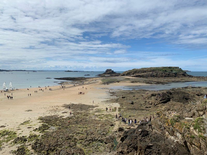
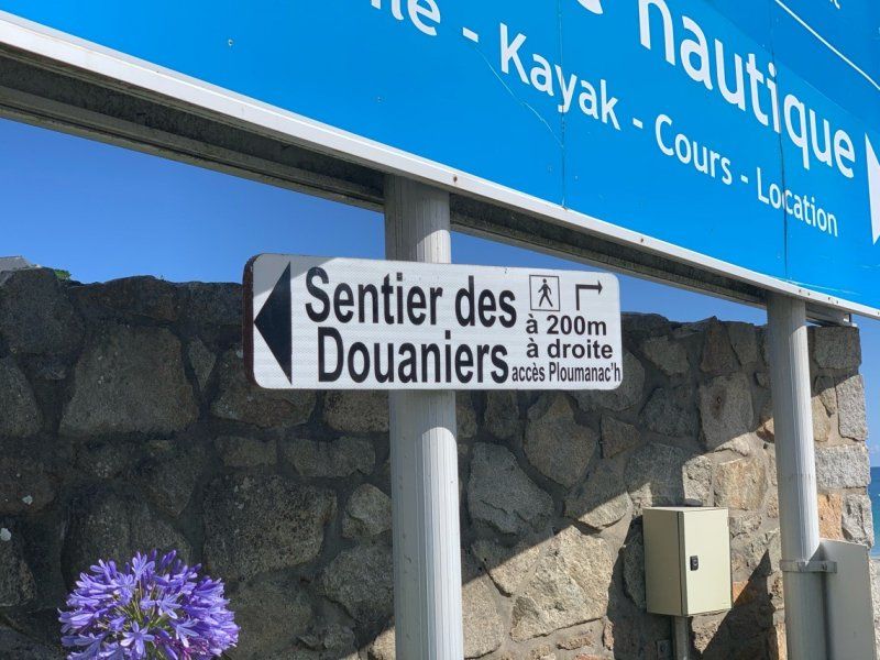
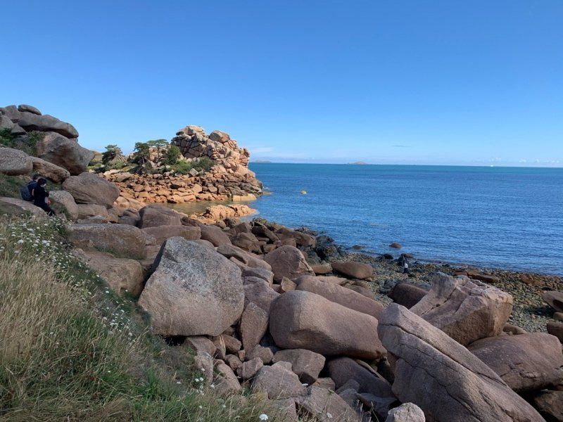
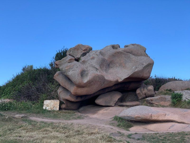
Sentier des Douaniers, Perros-Guirec, Frankreich
Sentier des Douaniers, 22700 Perros-Guirec, Frankreich
48° 49' 8.9" N 3° 27' 38.8" W
48.8191284 -3.4607684
• Head toward Résidence La Roseraie on Sentier des Douaniers. Go for 68 m.
• Turn right onto Résidence La Roseraie. Go for 10 m.
• Continue on Rue de la Clarté. Go for 200 m.
• Turn slightly right onto Rue de la Clarté. Go for 531 m.
• Turn right onto Boulevard du Sémaphore (D788). Go for 2.9 km.
• Pass 3 roundabouts and continue on Place Sainte-Anne (D788). Go for 1.6 km.
• Take the 3rd exit from roundabout onto Route de Trébeurden (D788). Go for 5.7 km.
• Turn right onto Rue de l'Île-Grande (D21). Go for 963 m.
• Continue on Rue du Pont (D21). Go for 469 m.
• Continue on Carrefour des Plages (D21). Go for 342 m.
• Continue on Rue du Port. Go for 321 m.
• Take the 2nd exit from roundabout onto Route de Toul Ar Stang. Go for 231 m.
• Arrive at Route de Toul Ar Stang. Your destination is on the left.
☍
13,4 km
( 20 min.)
Day
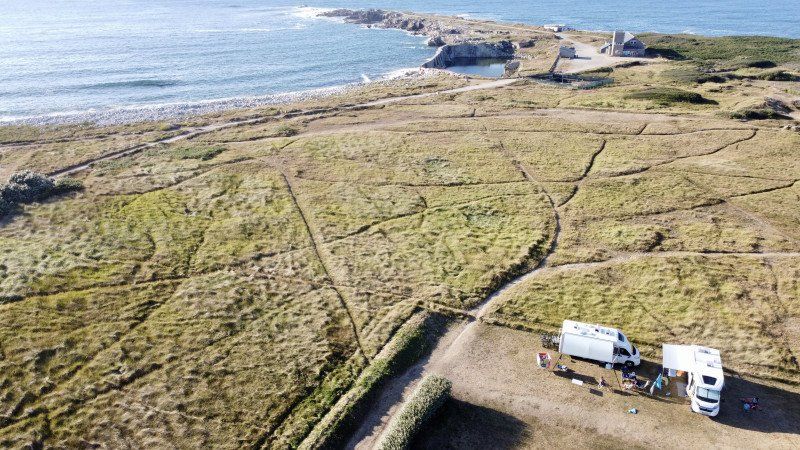
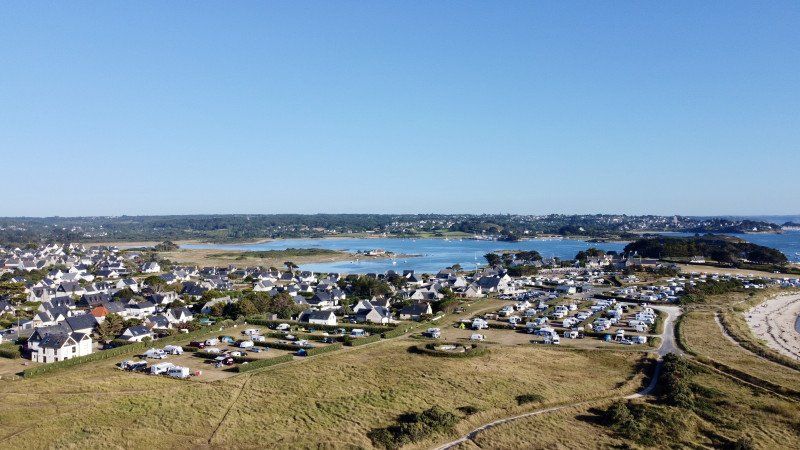
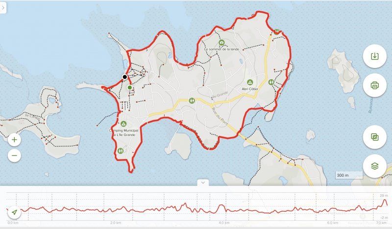
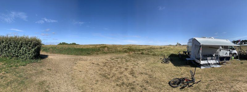
Camping Municipal Le Dourlin
22560, Pleumeur Bodou, Frankreich
48° 47' 56.4" N 3° 35' 3.5" W
48.7990000 -3.5843000
• Head northwest on Route de Toul Ar Stang.
• Arrive at Route de Toul Ar Stang. Your destination is on the left.
☍
Distance not available
(Duration not available)
Day
Camping Municipal Le Dourlin
22560, Pleumeur Bodou, Frankreich
48° 47' 56.4" N 3° 35' 3.5" W
48.7990000 -3.5843000
• Head northwest on Route de Toul Ar Stang.
• Arrive at Route de Toul Ar Stang. Your destination is on the left.
☍
Distance not available
(Duration not available)
Day
Camping Municipal Le Dourlin
22560, Pleumeur Bodou, Frankreich
48° 47' 56.4" N 3° 35' 3.5" W
48.7990000 -3.5843000
• Head toward Rue de Toul Ar Stang on Route de Toul Ar Stang. Go for 93 m.
• Continue on Route de Toul Ar Stang. Go for 121 m.
• Take the 2nd exit from roundabout onto Rue du Port. Go for 346 m.
• Continue on Rue des Îles (D21). Go for 192 m.
• Continue on Rue des Îles (D21). Go for 150 m.
• Continue on Rue du Pont (D21). Go for 469 m.
• Continue on Rue de l'Île-Grande (D21). Go for 963 m.
• Turn left onto Corniche de Goas Treiz (D788). Go for 304 m.
• Turn right onto Rue de Penvern (D21). Go for 206 m.
• Continue on Route de l'Île-Grande (D21). Go for 2.7 km.
• Continue on D21. Go for 28 m.
• Continue on Route de l'Île-Grande (D21). Go for 536 m.
• Take the 3rd exit from roundabout onto Route de l'Île-Grande (D6). Go for 304 m.
• Take the 2nd exit from roundabout onto Route de l'Île-Grande (D6). Go for 484 m.
• Take the 2nd exit from Rond-Point du Salut de la Clarté roundabout onto Route de Lannion (D21). Go for 2.3 km.
• Continue on D21. Go for 343 m.
• Continue on Lieu-dit Croaz Min (D21). Go for 101 m.
• Continue on D21. Go for 439 m.
• Turn left onto Route de Trébeurden (D21/D65). Go for 823 m.
• Take the 3rd exit from Rond-Point de Kerligonan roundabout onto Route de Trébeurden (D21). Go for 1.2 km.
• Continue on Avenue de la Résistance (D788). Go for 763 m.
• Take the 1st exit from roundabout onto Pont Viarmes (D786) toward Gare SNCF. Go for 56 m.
• Pass 2 roundabouts and continue on Route de Morlaix (D786). Go for 2.6 km.
• Take the 3rd exit from Giratoire du Détour du Yaudet roundabout onto Route de Morlaix (D786) toward Morlaix/Plestin les Grèves. Go for 3.3 km.
• Pass 2 roundabouts and continue on D786. Go for 3.1 km.
• Turn right toward Voie Romaine Beg Ar C'Hra. Go for 197 m.
• Turn left onto Voie Romaine Beg Ar C'Hra. Go for 737 m.
• Continue on Rue de l'Église. Go for 118 m.
• Turn left onto Rue de la Côte des Bruyères (D786). Go for 144 m.
• Turn left onto Rue de la Côte des Bruyères. Go for 39 m.
• Arrive at Rue de la Côte des Bruyères. Your destination is on the right.
☍
23,2 km
( 30 min.)
Day
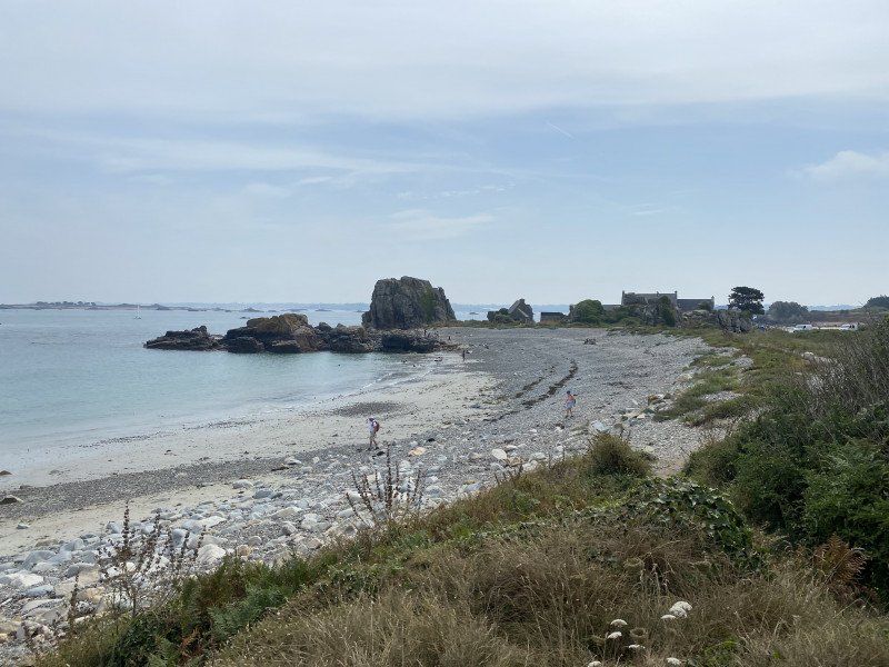
Saint-Michel-en-Grève, Frankreich
48° 41' 5.3" N 3° 33' 54.2" W
48.6847920 -3.5650430
• Head west on Rue de la Côte des Bruyères. Go for 39 m.
• Turn left onto Rue de la Côte des Bruyères (D786). Go for 228 m.
• Turn right onto Route de Keropartz (V1) toward Plouzélambre. Go for 36 m.
• Keep right onto Route de Keropartz (V1). Go for 30 m.
• Turn sharp right onto Route de Bellevue. Go for 135 m.
• Turn slightly left onto Route de Bellevue. Go for 1.2 km.
• Turn sharp right onto Route de Bellevue. Go for 42 m.
• Turn left onto Route d'Arvor (D786). Go for 3.8 km.
• Turn right onto Carrefour Croas An Haye (D42) toward Morlaix Par la Côte/Montroulez/Locquirec. Go for 1.4 km.
• Continue on Corniche de l'Armorique (D42). Go for 217 m.
• Arrive at Corniche de l'Armorique (D42). Your destination is on the left.
☍
7,1 km
( 11 min.)
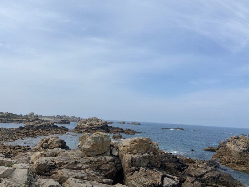
Kercoz, Plestin-les-Grèves, Frankreich
Kercoz, 22310 Plestin-les-Grèves, Frankreich
48° 40' 51.5" N 3° 37' 18.5" W
48.6809860 -3.6217980
• Head toward Rue de Pors Mellec on Corniche de l'Armorique (D42). Go for 990 m.
• Continue on Corniche du Douron (D42). Go for 1.5 km.
• Continue on Quai de Toul an Héry (D56). Go for 3.3 km.
• Turn right onto Vieille Côte. Go for 82 m.
• Continue on Place du Port. Go for 60 m.
• Continue on Rue de l'Église. Go for 155 m.
• Continue on Place de la France Libre. Go for 37 m.
• Arrive at Place de la France Libre. Your destination is on the left.
☍
6,1 km
( 8 min.)
Locquirec, Frankreich
48° 41' 33.4" N 3° 38' 42.3" W
48.6926230 -3.6450830
• Head southwest on Place de la France Libre. Go for 37 m.
• Turn right onto Rue de l'Église. Go for 91 m.
• Turn right onto Rue de l'Église. Go for 216 m.
• Turn right onto Rue Pors Ar Villiec (D64). Go for 2.5 km.
• Turn right onto Rue de la Corniche (D64 A). Go for 122 m.
• Arrive at Rue de la Corniche (D64 A). Your destination is on the left.
☍
2,9 km
( 4 min.)
Le Moulin de la Rive, Locquirec, Frankreich
Le Moulin de la Rive, 29241 Locquirec, Frankreich
48° 41' 10.4" N 3° 40' 42.2" W
48.6862210 -3.6783970
• Head east on Rue de la Corniche (D64 A). Go for 122 m.
• Turn right onto Lieu-dit Moulin de la Rive (D64). Go for 5.4 km.
• Turn right onto Route de Lanmeur à Plougasnou (D78). Go for 6.4 km.
• Take the 1st exit from roundabout onto Rue Mendès France (D79 A). Go for 343 m.
• Take the 3rd exit from Rond-Point du 19 Mars 1962 roundabout onto Rue François Charles (D79 A). Go for 268 m.
• Take the 1st exit from roundabout onto Rue François Charles (D79 A). Go for 55 m.
• Take the 2nd exit from roundabout onto Rue François Charles (D79 A). Go for 240 m.
• Arrive at Rue François Charles (D79 A). Your destination is on the right.
☍
12,8 km
( 13 min.)
Plougasnou, Frankreich
29630 Plougasnou, Frankreich
48° 41' 44" N 3° 47' 24.1" W
48.6955480 -3.7900330
• Head southeast on Rue François Charles (D79 A). Go for 224 m.
• Take the 1st exit from roundabout onto Rue François Charles (D79 A). Go for 59 m.
• Take the 2nd exit from roundabout onto Rue François Charles (D79 A). Go for 260 m.
• Take the 2nd exit from Rond-Point du 19 Mars 1962 roundabout onto Rue Mendès France (D79 A). Go for 338 m.
• Take the 2nd exit from roundabout onto Route Circuit du Trégor (D46). Go for 6.3 km.
• Take the 3rd exit from Carrefour du Rochou roundabout onto Route de Morlaix à Plougasnou (D46). Go for 6.1 km.
• Take the 2nd exit from Rond-Point Pont-Coz roundabout onto Rue du Cosquer (D46). Go for 763 m.
• Take the 1st exit from Rond-Point La Vierge Noire roundabout onto D786. Go for 1.8 km.
• Take the 2nd exit from roundabout onto Place Charles de Gaulle (D769). Go for 567 m.
• Turn left onto Place Émile Souvestre (D769). Go for 47 m.
• Continue on Rue Carnot (D19/D786). Go for 37 m.
• Turn left onto Rue du Pont Notre-Dame. Go for 55 m.
• Arrive at Rue du Pont Notre-Dame. Your destination is on the left.
☍
16,6 km
( 18 min.)
Morlaix, Frankreich
29600 Morlaix, Frankreich
48° 34' 39.4" N 3° 49' 41.6" W
48.5776130 -3.8282280
• Head toward Rue Carnot on Rue du Pont Notre-Dame. Go for 55 m.
• Turn left onto Rue Carnot (D19/D786). Go for 42 m.
• Turn left onto Rue d'Aiguillon (D786). Go for 200 m.
• Keep right onto Place des Otages (D786). Go for 371 m.
• Take the 3rd exit from roundabout onto Place Charles de Gaulle (D769). Go for 566 m.
• Take the 2nd exit from roundabout onto Route de Carantec (D769). Go for 5.7 km.
• Turn right and take ramp onto D58. Go for 6.9 km.
• Take the 3rd exit from roundabout onto D58 toward Port Roscoff/St Pol de Léon. Go for 4.4 km.
• Take the 2nd exit from Rond-Point de Pen Ar Prat roundabout onto D58 toward Port Roscoff/Brest/Landivisiau. Go for 1.7 km.
• Take the 2nd exit from Rond-Point de Lesvestric roundabout onto D788 toward Landivisiau/Brest/Lesneven/Port Roscoff/Plouescat/St Pol de Léon. Go for 823 m.
• Pass 3 roundabouts and continue on D58. Go for 2.3 km.
• Turn left onto VC6 toward Kéravel-Laber/Perharidy. Go for 65 m.
• Continue on Lieu-dit Keravel (VC6). Go for 88 m.
• Continue on VC6. Go for 334 m.
• Continue on Lieu-dit Kergadiou (VC6). Go for 129 m.
• Continue on VC6. Go for 26 m.
• Continue on VC7. Go for 1.1 km.
• Continue on Rue de Kérioual (VC7). Go for 266 m.
• Continue on Place du Laber (VC11). Go for 40 m.
• Continue on VC11. Go for 491 m.
• Turn left onto Rue des Dentelles. Go for 70 m.
• Turn right. Go for 26 m.
• Arrive at your destination.
☍
25,6 km
( 26 min.)
Camping Aux 4 Saisons, Allée des Chênes Verts, Roscoff, Frankreich
Very simple, outdated campsite right by the sea. A big plus is the navette to Roscoff.
Allée des Chênes Verts, 29680 Roscoff, Frankreich
48° 42' 50.9" N 4° 0' 31.2" W
48.7141411 -4.0086642
• Head toward Rue des Dentelles. Go for 26 m.
• Turn left onto Rue des Dentelles. Go for 70 m.
• Turn right onto VC11. Go for 491 m.
• Continue on Place du Laber (VC11). Go for 40 m.
• Turn left onto Place du Laber. Go for 24 m.
• Continue on Route du Laber. Go for 1.5 km.
• Turn right onto Rue de la Baie (VC11). Go for 441 m.
• Turn left onto Rue Laennec (D769). Go for 351 m.
• Continue on Rue Albert de Mun (D769). Go for 404 m.
• Turn right onto Rue Célestin Séïté. Go for 216 m.
• Continue on Rue des Johnnies. Go for 125 m.
• Continue on Rue Gambetta. Go for 37 m.
• Turn right onto Quai Parmentier. Go for 37 m.
• Turn left onto Quai Charles de Gaulle. Go for 68 m.
• Turn left onto Quai Parmentier. Go for 58 m.
• Turn right onto Rue Amiral Réveillère. Go for 53 m.
• Turn left onto Rue Armand Rousseau. Go for 72 m.
• Arrive at Rue Armand Rousseau. Your destination is on the right.
☍
4,0 km
( 8 min.)
Day
Roscoff, Frankreich
A very beautiful Breton village.
29680 Roscoff, Frankreich
48° 43' 34.3" N 3° 59' 7.2" W
48.7261990 -3.9853250
• Head toward Venelle An Iliz on Rue Armand Rousseau. Go for 20 m.
• Turn left onto Rue des Mogouerou. Go for 119 m.
• Turn right onto Rue Célestin Séïté. Go for 216 m.
• Turn left onto Rue Albert de Mun (D769). Go for 404 m.
• Continue on Rue Laennec (D769). Go for 351 m.
• Turn right onto Rue de la Baie. Go for 441 m.
• Turn left onto Route du Laber (VC11). Go for 1.5 km.
• Continue on Place du Laber. Go for 24 m.
• Turn right onto Place du Laber (VC11). Go for 40 m.
• Continue on VC11. Go for 491 m.
• Turn left onto Rue des Dentelles. Go for 70 m.
• Turn right. Go for 26 m.
• Arrive at your destination.
☍
3,7 km
( 7 min.)
Camping Aux 4 Saisons, Allée des Chênes Verts, Roscoff, Frankreich
Allée des Chênes Verts, 29680 Roscoff, Frankreich
48° 42' 50.9" N 4° 0' 31.2" W
48.7141411 -4.0086642
• Head toward Rue des Dentelles. Go for 26 m.
• Turn left onto Rue des Dentelles. Go for 70 m.
• Turn right onto VC11. Go for 491 m.
• Continue on Place du Laber (VC11). Go for 40 m.
• Continue on Place du Laber. Go for 266 m.
• Continue on VC7. Go for 1.1 km.
• Continue on VC6. Go for 26 m.
• Continue on Lieu-dit Kergadiou (VC6). Go for 129 m.
• Continue on VC6. Go for 334 m.
• Continue on Lieu-dit Keravel (VC6). Go for 88 m.
• Continue on VC6. Go for 65 m.
• Turn right onto D58. Go for 948 m.
• Pass 3 roundabouts and continue on Route de Brest à Saint-Pol-de-Léon (D788). Go for 2.1 km.
• Take the 2nd exit from Rond-Point de Lesvestric roundabout onto D58 toward Morlaix/Carantec. Go for 1.7 km.
• Pass 2 roundabouts and continue on Route Départementale No58 (D58). Go for 13.9 km.
• Keep left onto D19. Go for 1.6 km.
• Take the 2nd exit from roundabout onto Route de Plouvorn (D19) toward Morlaix/St Martin des C. Go for 399 m.
• Take the 4th exit from Rond-Point du Puits roundabout onto N12 toward St Brieuc/Rennes. Go for 40.7 km.
• Take ramp onto Rue des Tilleuls (D31) toward Bégard/Gurunhuel/Louargat. Go for 925 m.
• Take the 2nd exit from roundabout onto Allée Fao (D15). Go for 364 m.
• Take the 2nd exit from roundabout onto Allée Fao (D15). Go for 3.6 km.
• Turn left onto Rue de Botlézan (D93). Go for 841 m.
• Continue on Lieu-dit Gwaremm Goahic (D93). Go for 1.4 km.
• Continue on Rue Alexandrine Tilly (D93). Go for 580 m.
• Continue on Hent Penn Lann (D93). Go for 366 m.
• Continue on D93. Go for 3.8 km.
• Take the 1st exit from roundabout onto D33. Go for 629 m.
• Turn right onto Lieu-dit Breiz Izel (D33). Go for 11.1 km.
• Turn left onto Rue du Chef du Pont. Go for 742 m.
• Turn right onto Route du Moulin de la Forge (D72). Go for 212 m.
• Turn left onto D8. Go for 642 m.
• Pass 2 roundabouts and continue on D8. Go for 3.8 km.
• Take the 2nd exit from roundabout onto Boulevard Jean Guéhenno (D786). Go for 1.1 km.
• Take the 2nd exit from roundabout onto Rue Marcellin Berthelot (D70). Go for 469 m.
• Continue on Place du Général de Gaulle (D70). Go for 298 m.
• Take the 2nd exit from roundabout onto Rue du Port (D70). Go for 260 m.
• Take the 1st exit from roundabout onto D8. Go for 141 m.
• Continue on Rue de Tréguier (D8). Go for 1.1 km.
• Take the 1st exit from roundabout onto Rue du Stade (D8). Go for 1.1 km.
• Continue on Lieu-dit Keriou (D8). Go for 416 m.
• Continue on D8. Go for 544 m.
• Continue on Lieu-dit Kervélez (D8). Go for 132 m.
• Continue on D8. Go for 732 m.
• Continue on Lieu-dit Kergroas (D8). Go for 78 m.
• Continue on D8. Go for 519 m.
• Continue on Rue de Tréguier (D8). Go for 1.8 km.
• Take the 3rd exit from roundabout onto Hent Saint-Gonnery. Go for 209 m.
• Turn slightly right onto Hent Saint-Gonnery. Go for 146 m.
• Continue on Hent Castel Meur. Go for 581 m.
• Continue on Hent Castel Meur. Go for 825 m.
• Turn right onto Crec'h Louarn. Go for 234 m.
• Turn left onto Rue Crec'h Kermorvan. Go for 171 m.
• Turn right onto Rue Crec'h Kermorvan. Go for 178 m.
• Arrive at Rue Crec'h Kermorvan. Your destination is on the right.
☍
104,2 km
(1 hrs. 25 min.)
Day
camping du Gouffre, Rue Crec'h Kermorvan, Plougrescant, Frankreich
A very small clean campsite
Rue Crec'h Kermorvan, 22820 Plougrescant, Frankreich
48° 51' 36.2" N 3° 13' 37.3" W
48.8600679 -3.2270250
• Head toward Hent Pors Bugalez on Rue Crec'h Kermorvan. Go for 158 m.
• Turn left onto Hent Pors Bugalez. Go for 75 m.
• Turn left onto Hent Pors Bugalez. Go for 167 m.
• Continue on Hent Castel Meur. Go for 1.4 km.
• Continue on Hent Castel Meur. Go for 526 m.
• Turn right onto Lieu-dit Kernevez Hent Castel Meur. Go for 79 m.
• Turn left onto Hent Roudour. Go for 117 m.
• Turn right onto Hent Pompelidec. Go for 590 m.
• Continue on Hent Poul Marc'h. Go for 18 m.
• Turn right onto Hent Landreger (D8). Go for 72 m.
• Arrive at Hent Landreger (D8). Your destination is on the right.
☍
3,2 km
( 7 min.)
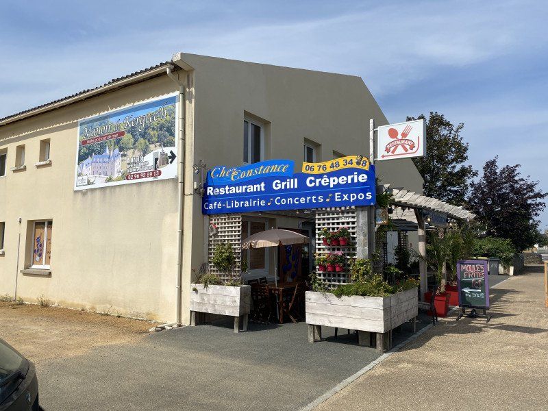
Chez Constance, Rue Landreger, Plougrescant, Frankreich
A very nice restaurant/bookstore/artists' room
6 Rue Landreger, 22820 Plougrescant, Frankreich
48° 50' 16.8" N 3° 13' 57.2" W
48.8380013 -3.2325685
• Head toward Rue du 19 Mars 1962 on Hent Landreger (D8). Go for 638 m.
• Take the 2nd exit from roundabout onto Hent Garden Post. Go for 130 m.
• Turn right onto Hent Toul al Ouarn. Go for 241 m.
• Turn slightly right onto Lieu-dit Pempont Hent Pors Hir. Go for 619 m.
• Continue on Lieu-dit Pors Hir. Go for 358 m.
• Continue on Lieu-dit Keraudren Hent Pors Hir. Go for 536 m.
• Continue on Lieu-dit Pors Hir. Go for 261 m.
• Continue on Hent Pors Hir. Go for 196 m.
• Continue on Hent Pors Hir. Go for 84 m.
• Turn slightly right onto Hent Pors Hir. Go for 246 m.
• Continue on Lieu-dit La Plage Hent Pors Hir. Go for 11 m.
• Arrive at Lieu-dit La Plage Hent Pors Hir. Your destination is on the right.
☍
3,3 km
( 7 min.)
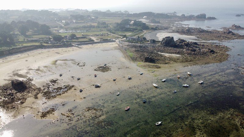
Plage de Porz Hir, Frankreich
48° 51' 52.1" N 3° 13' 4.4" W
48.8644748 -3.2178845
• Head north on Lieu-dit La Plage Hent Pors Hir. Go for 97 m.
• Turn left toward Lieu-dit Pors Hir Hent Kericu. Go for 278 m.
• Turn slightly right onto Lieu-dit Pors Hir Hent Kericu. Go for 60 m.
• Turn slightly left onto Lieu-dit Pors Hir Hent Kericu. Go for 180 m.
• Turn left onto Garec Soul Hent Pors Bugalez. Go for 85 m.
• Continue on Hent Pors Bugalez. Go for 273 m.
• Turn left onto Rue Crec'h Kermorvan. Go for 158 m.
• Arrive at Rue Crec'h Kermorvan. Your destination is on the left.
☍
1,1 km
( 3 min.)
Day
camping du Gouffre, Rue Crec'h Kermorvan, Plougrescant, Frankreich
Rue Crec'h Kermorvan, 22820 Plougrescant, Frankreich
48° 51' 36.2" N 3° 13' 37.3" W
48.8600679 -3.2270250
• Head toward Hent Pors Bugalez on Rue Crec'h Kermorvan. Go for 158 m.
• Turn right onto Hent Pors Bugalez. Go for 273 m.
• Continue on Garec Soul Hent Pors Bugalez. Go for 85 m.
• Turn slightly left onto Hent Pors Bugalez. Go for 127 m.
• Turn left onto Hent Castel Meur. Go for 688 m.
• Turn right onto Hent Castel Meur. Go for 267 m.
• Arrive at Hent Castel Meur.
☍
1,6 km
( 4 min.)
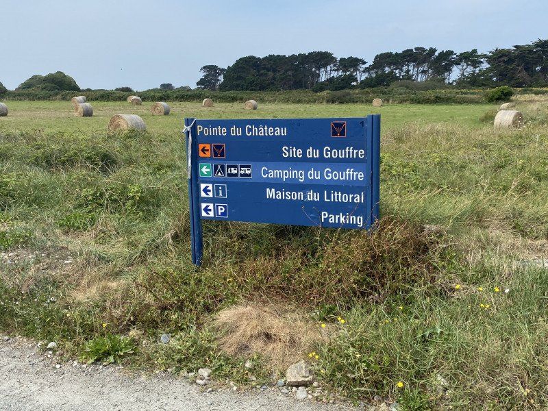
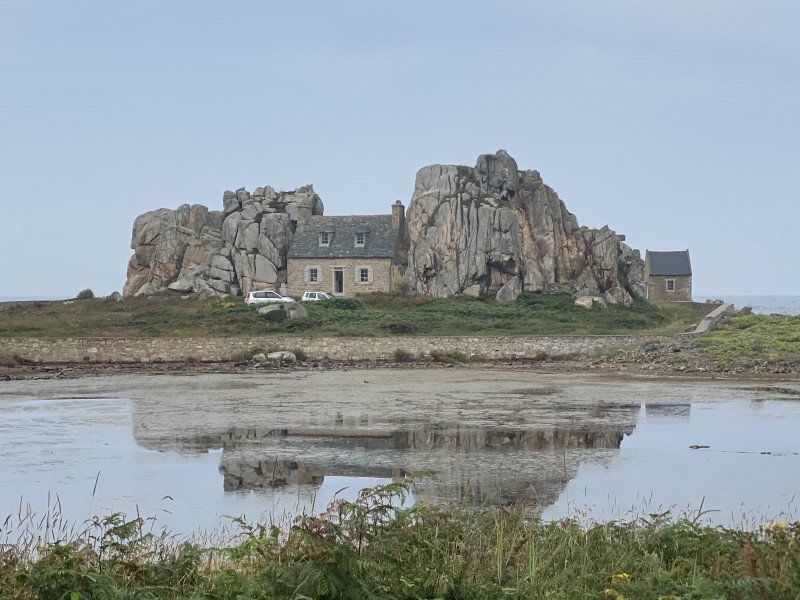
Le gouffre de Plougrescant, Plougrescant, Frankreich
Probably the most famous house in Brittany
22820 Plougrescant, Frankreich
48° 52' 0.5" N 3° 14' 15.8" W
48.8668154 -3.2377256
• Head toward Lieu-dit Le Gouffre Hent Castel Meur on Hent Castel Meur. Go for 16 m.
• Turn slightly right onto Hent Castel Meur. Go for 2.1 km.
• Continue on Hent Castel Meur. Go for 526 m.
• Turn right onto Lieu-dit Kernevez Hent Castel Meur. Go for 79 m.
• Turn left onto Hent Roudour. Go for 117 m.
• Turn right onto Hent Pompelidec. Go for 590 m.
• Continue on Hent Poul Marc'h. Go for 18 m.
• Turn right onto Hent Landreger (D8). Go for 1.3 km.
• Continue on D8. Go for 519 m.
• Continue on Lieu-dit Kergroas (D8). Go for 78 m.
• Continue on D8. Go for 732 m.
• Continue on Lieu-dit Kervélez (D8). Go for 132 m.
• Continue on D8. Go for 544 m.
• Continue on Lieu-dit Keriou (D8). Go for 416 m.
• Continue on Rue du Stade (D8). Go for 1.1 km.
• Take the 2nd exit from roundabout onto Rue de Tréguier (D8). Go for 1.2 km.
• Continue on D8. Go for 127 m.
• Take the 2nd exit from roundabout onto Rue du Port (D70). Go for 251 m.
• Take the 1st exit from roundabout onto Place du Général de Gaulle (D70). Go for 252 m.
• Continue on Place du Général de Gaulle (D70). Go for 68 m.
• Continue on Place du Général de Gaulle (D70). Go for 414 m.
• Take the 2nd exit from roundabout onto D786. Go for 2.2 km.
• Pass 4 roundabouts and continue on Avenue du Trégor (D786). Go for 11.4 km.
• Take the 4th exit from roundabout onto D786. Go for 1.4 km.
• Take the 2nd exit from roundabout onto D7. Go for 14.4 km.
• Continue on Lieu-dit La Boissière (D6). Go for 971 m.
• Take the 2nd exit from roundabout onto Rue des Prés (D6). Go for 1.1 km.
• Take the 3rd exit from roundabout onto D6. Go for 16.0 km.
• Turn left toward N12. Go for 69 m.
• Take ramp onto N12. Go for 100 km.
• Take ramp onto N1012 toward Rennes-Centre/C.H.U. Pontchaillou/Rocade Sud/Angers/Nantes. Go for 2.0 km.
• Take ramp onto Rocade Ouest (N136) toward Angers/Nantes. Go for 8.6 km.
• Take ramp toward Porte d'Angers/Angers/Vern S/ Seiche/La Poterie/C.H.U. Hôpital Sud/Écomusée Pays de Rennes. Go for 436 m.
• Keep right toward D173/Angers/Vern S/ Seiche. Go for 317 m.
• Continue on D173. Go for 482 m.
• Pass 2 roundabouts and continue on D173. Go for 4.2 km.
• Take the 3rd exit from Rond-Point du Pâtis Fraux roundabout onto D173 toward Angers/St Erblon/Janzé/Châteaubriant. Go for 43.8 km.
• Continue on D775. Go for 3.8 km.
• Pass 2 roundabouts and continue on D775. Go for 22.3 km.
• Take the 3rd exit from roundabout onto D775 toward Angers/Segré. Go for 5.8 km.
• Take the 2nd exit from roundabout onto D775 toward Le Lion d'A./Candé. Go for 1.8 km.
• Take the 4th exit from Rond-Point de l'Europe roundabout onto D775 toward Angers/Le Lion d'Angers. Go for 12.3 km.
• Take the 2nd exit from roundabout onto D775 toward Angers/Montreuil-Juigné/Le Lion d'Angers/Z.I. la Coudère. Go for 1.7 km.
• Take the 4th exit from roundabout onto D775 toward Angers/Z.I. la Coudère. Go for 1.6 km.
• Pass 2 roundabouts and continue on D775. Go for 16.0 km.
• Take ramp toward Paris/Tours. Go for 304 m.
• Take the 3rd exit from roundabout onto A11 (L'Océane) toward Paris/Tours. Go for 23.7 km.
• Take the exit toward Saumur/Tours onto A85. Go for 37.1 km.
• Take exit 3 toward Saumur. Go for 1.1 km.
• Take the 2nd exit from roundabout onto D767 toward Saumur. Go for 527 m.
• Take the 3rd exit from Rond-Point de la Ronde roundabout onto D347 toward Saumur/Cholet. Go for 2.4 km.
• Take the 3rd exit from Rond-Point du Fleuret roundabout toward Saumur-Nord. Go for 116 m.
• Turn right onto Avenue des Fusillés. Go for 1.5 km.
• Take the 3rd exit from Rond-Point des Fusillés roundabout onto Rue de Rouen. Go for 1.0 km.
• Take the 2nd exit from roundabout onto Place de la Résistance. Go for 82 m.
• Take the 2nd exit from Rond-Point Noëlla Rouget roundabout onto Pont des Cadets de Saumur (D947) toward Centre Ville/Les Ponts. Go for 247 m.
• Take the 4th exit from roundabout onto Quai du Roi René. Go for 332 m.
• Continue on Rue de Verden. Go for 467 m.
• Turn left. Go for 33 m.
• Arrive at your destination on the left.
☍
352,2 km
(3 hrs. 43 min.)
Day
Flower Camping l'Ile D'offard
rue de Verden, 49400, Saumur, Frankreich
47° 15' 37.1" N 0° 3' 55.1" W
47.2603000 -0.0653000
• Head northeast.
• Turn left onto Rue de Verden. Go for 202 m.
• Turn slightly left onto Rue des Aulnes. Go for 252 m.
• Turn right onto Rue des Capucins-d'Offard. Go for 45 m.
• Turn left onto Rue des Capucins-d'Offard. Go for 67 m.
• Continue on Rue Paul Bert. Go for 238 m.
• Take the 2nd exit from roundabout onto Avenue du Général de Gaulle (D947). Go for 408 m.
• Take the 2nd exit from roundabout onto Quai Lucien Gautier (D947). Go for 423 m.
• Take the 3rd exit from roundabout onto Quai Mayaud (D947). Go for 135 m.
• Turn right onto Place Saint-Michel. Go for 16 m.
• Continue on Petite Rue Saint-Michel. Go for 77 m.
• Turn left onto Rue Jean Jaurès. Go for 14 m.
• Arrive at Rue Jean Jaurès. Your destination is on the right.
☍
1,9 km
( 4 min.)
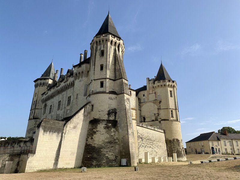
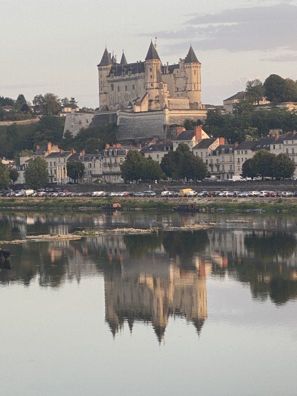
Château Saumur, Saumur, Frankreich
49400 Saumur, Frankreich
47° 15' 25.4" N 0° 4' 20.6" W
47.2570635 -0.0724003
• Head east on Rue Jean Jaurès. Go for 48 m.
• Turn left onto Rue Raspail. Go for 95 m.
• Turn slightly right onto Place Saint-Michel. Go for 16 m.
• Turn left onto Quai Mayaud (D947). Go for 105 m.
• Take the 1st exit from roundabout onto Quai Lucien Gautier (D947). Go for 398 m.
• Take the 1st exit from roundabout onto Pont Cessart (D947). Go for 397 m.
• Pass 3 roundabouts and continue on Pont des Cadets de Saumur (D947). Go for 452 m.
• Take the 2nd exit from Rond-Point Noëlla Rouget roundabout onto Rue de Rouen toward St Lambert/Saumur-Nord. Go for 85 m.
• Take the 2nd exit from roundabout onto Rue de Rouen. Go for 986 m.
• Take the 2nd exit from Rond-Point des Fusillés roundabout onto Avenue des Fusillés. Go for 1.8 km.
• Continue on D347. Go for 2.2 km.
• Take the 2nd exit from Rond-Point de la Ronde roundabout onto D767 toward Angers/Tours/Le Mans/Allonnes/Vernantes. Go for 577 m.
• Take the 3rd exit from roundabout toward Le Mans/Angers/Tours. Go for 161 m.
• Take ramp onto A85 toward Nantes/Le Mans/Angers. Go for 36.9 km.
• Take the exit toward Paris/Le Mans onto A11 (L'Océane). Go for 220 km.
• Continue on A10 (L'Aquitaine). Go for 34.2 km.
• Take the exit toward Lille/A1/Paris/A6/Rungis/Aéroport Orly onto A10. Go for 3.6 km.
• Keep right toward A6 B/E15/A86/A1/Lille/Rungis/Aéroport Orly. Go for 502 m.
• Continue on Voie des Molières. Go for 145 m.
• Continue toward A6 B. Go for 170 m.
• Continue on A6 B. Go for 1.8 km.
• Take the exit toward A4/Lille/A1/Créteil/Aéroport Orly/Rungis onto N186. Go for 1.9 km.
• Keep left onto N186 toward A86/Lille/Metz/Nancy/Créteil. Go for 1.9 km.
• Keep left onto A86 toward Sénia/Lille/Metz/Nancy/Vitry/Créteil/Thiais-Centre/Parc Interdal des Sports. Go for 11.0 km.
• Take the exit onto A4/A86. Go for 2.7 km.
• Keep left onto A4 (Autoroute de l'Est). Go for 104 km.
• Take exit 21 toward Épernay onto D980. Go for 13.4 km.
• Take the 1st exit from roundabout onto Lieu-dit Herbemont (D386) toward Épernay. Go for 7.1 km.
• Take the 1st exit from roundabout onto D386. Go for 7.8 km.
• Turn left onto Rue Henri Martin (D386). Go for 208 m.
• Turn left onto Rue Dom Pérignon (D386). Go for 23 m.
• Turn right onto Rue de Bacchus. Go for 24 m.
• Arrive at Rue de Bacchus. Your destination is on the right.
☍
454,6 km
(4 hrs. 4 min.)
Day
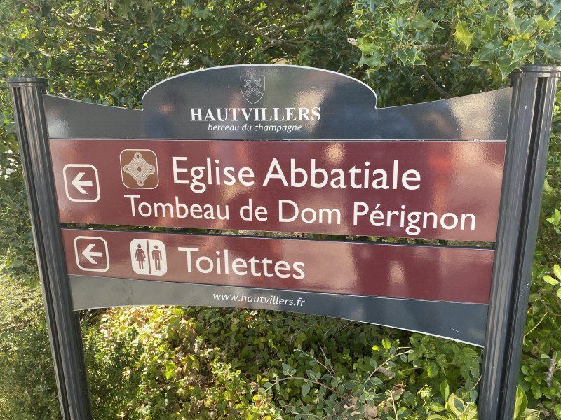
Hautvillers, Frankreich
51160 Hautvillers, Frankreich
49° 5' 0.6" N 3° 56' 43.9" E
49.0834880 3.9455410
• Head toward Rue Dom Pérignon on Rue de Bacchus. Go for 24 m.
• Turn right onto Rue Dom Pérignon (D386). Go for 305 m.
• Turn left onto Rue de la Croix de Fer (D386). Go for 74 m.
• Turn right onto Rue de Cumières. Go for 44 m.
• Turn right onto Rue de l'Église. Go for 36 m.
• Turn left onto Rue de l'Abbaye. Go for 53 m.
• Arrive at Rue de l'Abbaye. Your destination is on the right.
☍
0,5 km
( 1 min.)
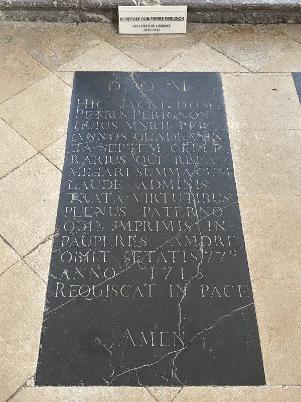
Abtei Hautvillers, Rue de l'Abbaye, Hautvillers, Frankreich
21 Rue de l'Abbaye, 51160 Hautvillers, Frankreich
49° 4' 55" N 3° 56' 27.8" E
49.0819536 3.9410581
• Head northeast on Rue de l'Abbaye. Go for 53 m.
• Arrive at Rue de l'Abbaye. Your destination is on the right.
☍
0,1 km
( )
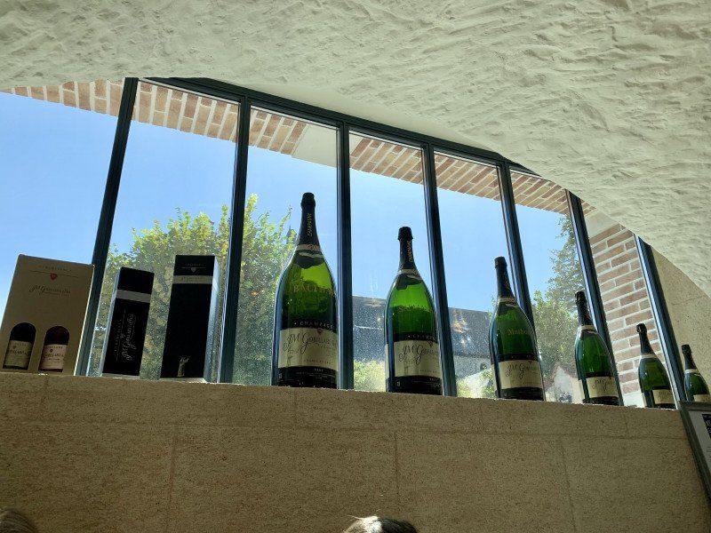
Champagne J.M. Gobillard et Fils, Rue de l'Église, Hautvillers, Frankreich
38 Rue de l'Église, 51160 Hautvillers, Frankreich
49° 4' 56.1" N 3° 56' 31" E
49.0822634 3.9419506
• Head northeast on Rue de l'Abbaye.
• Turn left onto Rue de l'Église. Go for 110 m.
• Turn right onto Rue de l'Aubrois. Go for 94 m.
• Turn right onto Rue de la Croix de Fer (D386). Go for 158 m.
• Turn right onto Rue de Cumières. Go for 541 m.
• Continue on Route d'Hautvillers. Go for 866 m.
• Turn right onto Rue de Dizy (D1). Go for 4.1 km.
• Take the 2nd exit from roundabout onto Rue Georges Clemenceau (D1). Go for 7.0 km.
• Continue on D1. Go for 2.6 km.
• Take the 2nd exit from roundabout onto D1. Go for 2.6 km.
• Turn right onto Rue Principale. Go for 209 m.
• Turn left onto Rue Bailly. Go for 104 m.
• Turn right onto Cour Baptiste Nowack. Go for 20 m.
• Arrive at Cour Baptiste Nowack. Your destination is on the left.
☍
18,5 km
( 22 min.)
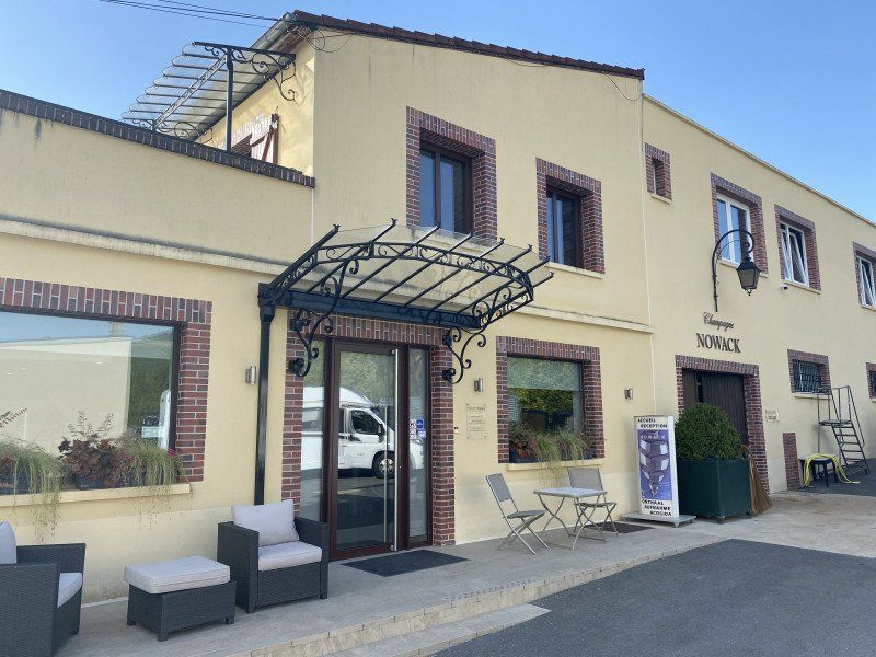
Champagne Nowack, Rue Bailly, Vandières, Frankreich
Very convenient and idyllic, try Champagne and camp there!
10 Rue Bailly, 51700 Vandières, Frankreich
49° 6' 23.8" N 3° 44' 2.5" E
49.1066246 3.7340320
• Head toward Rue Bailly on Cour Baptiste Nowack. Go for 20 m.
• Turn left onto Rue Bailly. Go for 104 m.
• Turn right onto Rue Principale. Go for 209 m.
• Turn left onto Rue du Moulin (D1). Go for 2.6 km.
• Take the 2nd exit from roundabout onto D1. Go for 2.2 km.
• Continue toward D601. Go for 40 m.
• Continue on Rue du Chemin Vert (D1). Go for 514 m.
• Continue on Place Godard (D601). Go for 19 m.
• Continue on D601. Go for 655 m.
• Turn left onto D3. Go for 9.9 km.
• Take the 2nd exit from roundabout onto Route Nationale (D3) toward Épernay/Z.I. de Mardeuil. Go for 2.2 km.
• Take the 2nd exit from Avenue Jean Jaurès roundabout onto Rue Saint-Laurent toward A26 (Lille)/Reims/Ay/Z.A.C. des Docks/Z.I. Nord/Z.A. Val de Champagne/Z.I. de l'Île Belon/Avenue de Champagne. Go for 159 m.
• Take the 1st exit from roundabout onto Rue de la Tour Biron toward A26/Reims/Ay/Z.A.C. des Docks/Z.I. Nord/Z.A. Val de Champagne/Z.I. de l'Île Belon/Avenue de Champagne. Go for 147 m.
• Take the 2nd exit from Place Léon Bourgeois roundabout onto Rempart Perrier. Go for 280 m.
• Take the 3rd exit from Place Mendès France roundabout onto Place Pierre Mendès France. Go for 99 m.
• Continue on Rue de Reims (N2051) toward (Metz)/A4/(Troyes)/A26/Chalons en Ch./Magenta/Ay. Go for 221 m.
• Keep right onto Rue de Reims (N2051). Go for 18 m.
• Turn right onto Rue de Verdun. Go for 779 m.
• Take the 3rd exit from Place de Champagne roundabout onto Avenue de Champagne (D3) toward (Metz)/A4/(Troyes)/A26/Chalons en Ch. Go for 410 m.
• Arrive at Avenue de Champagne (D3). Your destination is on the right.
☍
20,6 km
( 21 min.)
Day
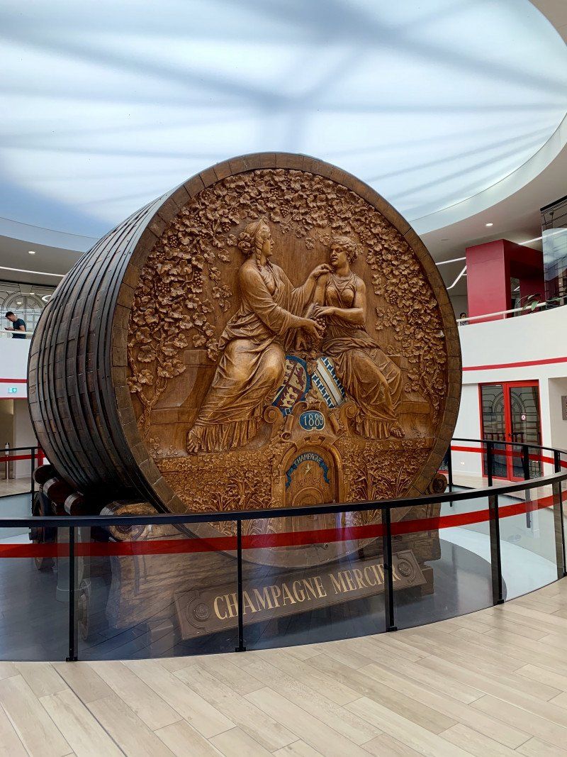
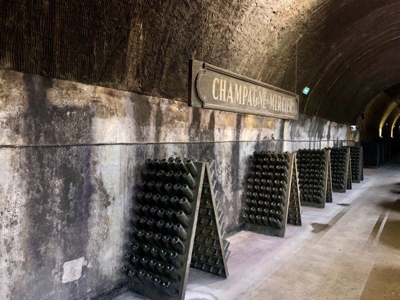
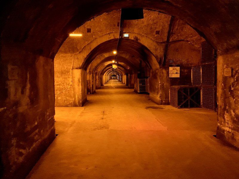
La Villa Eugène, Avenue de Champagne, Épernay, Frankreich
Visit to the world-famous MERCIER winery to round off the trip
Avenue de Champagne, 51200 Épernay, Frankreich
49° 2' 24" N 3° 58' 26" E
49.0399994 3.9738805
• Head toward Rue Emmanuel Chabrier on Avenue de Champagne (D3). Go for 2.6 km.
• Continue toward (Metz)/A4/(Troyes)/A26/Châlons en Ch./Oiry. Go for 41 m.
• Take the 1st exit from roundabout onto D40 A toward Oiry. Go for 356 m.
• Continue on D3. Go for 2.5 km.
• Take the 2nd exit from roundabout onto D3 toward A4/A26/Châlons en Ch. Go for 18.6 km.
• Take the 3rd exit from roundabout onto D3 toward A26/Châlons en Champagne/Fagnières/St Gibrien. Go for 1.4 km.
• Take the 1st exit from roundabout onto A26 toward Reims/Metz. Go for 10.3 km.
• Take the exit toward Strasbourg/Metz/Verdun onto A4 (Autoroute de l'Est). Go for 103 km.
• Take exit 30 toward Étain/Longwy. Go for 1.4 km.
• Take the 2nd exit from roundabout onto D908 toward Étain/Longwy. Go for 7.1 km.
• Take the 2nd exit from roundabout onto D603 toward Longwy/Verdun/Étain. Go for 2.6 km.
• Take the 1st exit from roundabout onto D603 toward Longwy/Verdun/Étain. Go for 1.2 km.
• Take the 2nd exit from roundabout onto D603 toward Longwy/Verdun/Étain. Go for 405 m.
• Take the 1st exit from roundabout onto D618 toward Longwy/Spincourt/Bouligny. Go for 21.2 km.
• Turn right onto D66 toward Arrancy sur C./Pierrepont/Fort de Fermont. Go for 2.7 km.
• Continue on Rue du Milieu (D66). Go for 809 m.
• Continue on D66. Go for 24 m.
• Continue on D66 A. Go for 988 m.
• Continue on Rue Victor Hugo (D66 A). Go for 115 m.
• Continue on D18. Go for 320 m.
• Continue on Route d'Arrancy (D18). Go for 2.0 km.
• Continue on Rue Jean Moulin (D18). Go for 1.9 km.
• Continue on D18. Go for 3.9 km.
• Continue on Rue du Pâquis (D18). Go for 778 m.
• Take the 2nd exit from roundabout onto Place Louis Dorion (D18). Go for 851 m.
• Continue on D18. Go for 251 m.
• Continue on Rue de Cutry (D18). Go for 264 m.
• Turn left onto Rue de Cutry (D18). Go for 1.3 km.
• Continue on D18. Go for 439 m.
• Continue on Rue de Longwy (D18). Go for 1.2 km.
• Continue on Avenue de la Providence (D18). Go for 85 m.
• Turn right onto Rue Lavoisier. Go for 95 m.
• Turn right onto Rue de Metz (D520). Go for 823 m.
• Continue on Avenue de Saintignon (D918 A). Go for 224 m.
• Take the 1st exit from roundabout onto Avenue de Saintignon (D918 A). Go for 191 m.
• Pass 3 roundabouts and continue on Avenue de Saintignon. Go for 1.9 km.
• Take the 3rd exit from roundabout onto Avenue de l'Europe (D918 A). Go for 807 m.
• Take the 2nd exit from roundabout onto Rue Ernest Hemingway (D918 A). Go for 1.5 km.
• Take the 1st exit from roundabout onto Rue Jacques Prévert (D618). Go for 277 m.
• Take the 2nd exit from roundabout onto Avenue du Luxembourg (D618). Go for 335 m.
• Continue on N5. Go for 727 m.
• Turn right onto Route de Longwy (N5). Go for 912 m.
• Turn right onto Chemin de Brouck. Go for 417 m.
• Turn left onto Rue Jos. Moscardo. Go for 116 m.
• Arrive at Rue Jos. Moscardo.
☍
198,5 km
(2 hrs. 12 min.)
Rue Jos Moscardo, Petingen, Luxemburg
Rue Jos Moscardo, 4741 Pétange, Luxemburg
49° 32' 47.9" N 5° 50' 12.6" E
49.5466526 5.8368287