Our very first vacation in a camper. From to Kassel, where we rented a Fiat Ducato with a Sunlight body. There were two of us with our Bernese mountain dog Laika. We traveled through Denmark, Norway and Sweden.
Day
Kloten, Schweiz
Neubrunnenstrasse 25, 8302 Kloten, Schweiz
47° 26' 43.7" N 8° 34' 31.3" E
47.4454786 8.5753637
• Head toward Lägernstrasse on Neubrunnenstrasse. Go for 73 m.
• Turn right onto Werftstrasse. Go for 374 m.
• Take the 1st exit from roundabout onto Werftstrasse. Go for 73 m.
• Take the 2nd exit from roundabout onto Flughofstrasse. Go for 646 m.
• Continue on Birchstrasse. Go for 1.0 km.
• Keep left onto Birchstrasse. Go for 701 m.
• Take ramp onto A1/A4 toward Bern/Basel/Luzern/Chur. Go for 9.3 km.
• Take the exit toward Bern/Basel/Dietikon onto A1 (Limmattaler Kreuz). Go for 16.4 km.
• Take exit 53 toward Basel/Brugg onto A3. Go for 42.0 km.
• Take exit 14A toward Deutschland/Rheinfelden-West. Go for 1.0 km.
• Continue on A861. Go for 88 m.
• Continue on A861. Go for 4.1 km.
• Take the left exit onto A98 (Dorfbachtalbrücke). Go for 16.3 km.
• Take exit 1 toward Karlsruhe/Stuttgart/Freiburg onto A5. Go for 287 km.
• Take the exit toward Hannover/Kassel/Frankfurt/Darmstadt onto A5. Go for 111 km.
• Take left exit 4 toward Kassel/Dortmund onto A49. Go for 82.7 km.
• Take exit 5 toward Kassel-Auestadion/Kassel-Stadtmitte onto B3. Go for 2.0 km.
• Keep right toward Göttingen/Zentrum. Go for 142 m.
• Continue on Frankfurter Straße (B3). Go for 1.8 km.
• Keep right onto Frankfurter Straße (B3). Go for 5.3 km.
• Turn left onto L3234 toward Vellmar/Ful.-Ihringshausen-Mitte. Go for 122 m.
• Turn right onto Arwed-Hahn-Straße. Go for 42 m.
• Turn right. Go for 15 m.
• Turn left. Go for 20 m.
• Arrive at your destination.
☍
582,5 km
(5 hrs. 9 min.)
Fuldatal, Deutschland
Übernahme des Campers bei Windisch-Wohnmobilen. Ein Familienunternehmen in Kassel, dass auch im Namen von McRent Wohnmobile vertreibt.
Arwed-Hahn Straße 2, 34233 Fuldatal, Deutschland
51° 21' 10.8" N 9° 30' 54.4" E
51.3530134 9.5151049
• Head southwest. Go for 20 m.
• Turn right toward Arwed-Hahn-Straße. Go for 15 m.
• Turn left onto Arwed-Hahn-Straße. Go for 42 m.
• Turn left onto L3234. Go for 122 m.
• Turn right onto B3. Go for 3.6 km.
• Turn left onto Ysenburgstraße toward Eisenach/B7/Bebra/B83. Go for 502 m.
• Turn slightly left onto Scharnhorststraße (B7/B83) toward Eisenach/Bebra. Go for 507 m.
• Keep left onto Scharnhorststraße (B7/B83) toward Gewerbegebiet Miramstraße. Go for 90 m.
• Turn left onto Dresdener Straße (L3237). Go for 3.2 km.
• Take ramp onto A7 toward Hamburg/Hannover. Go for 234 km.
• Take exit 44 toward Uelzen/Munster/Lüneburg onto B71/B209. Go for 3.2 km.
• Turn left onto Stübeckshorn (B209). Go for 4.0 km.
• Take the 2nd exit from roundabout onto B209 toward Lüneburg. Go for 30.7 km.
• Turn left and take ramp toward Rettmer/Embsen. Go for 168 m.
• Turn left onto Lüneburger Straße (K17). Go for 4.1 km.
• Continue on Soltauer Allee. Go for 594 m.
• Continue on Hasenburg. Go for 774 m.
• Continue on Munstermannskamp. Go for 662 m.
• Turn left onto Uelzener Straße. Go for 1.2 km.
• Turn right onto Lindenstraße. Go for 455 m.
• Turn left onto Rote Straße. Go for 172 m.
• Turn right onto Haagestraße. Go for 163 m.
• Arrive at Haagestraße.
☍
287,8 km
(2 hrs. 57 min.)
Lüneburg, Deutschland
Zu Besuch bei Moritz und Kati. Leckeres Abendessen bei 30°C im Garten der benachbarten Pizzaria und am nächsten Morgen Frühstück vom Markt.
Haagestraße 1, 21335 Lüneburg, Deutschland
53° 14' 47.1" N 10° 24' 41.5" E
53.2464214 10.4115179
• Head toward Kalandstraße on Haagestraße. Go for 45 m.
• Turn slightly left onto Kalandstraße. Go for 160 m.
• Turn left onto Rote Straße. Go for 219 m.
• Turn right onto Lindenstraße. Go for 455 m.
• Continue on Soltauer Straße. Go for 283 m.
• Keep right onto Bögelstraße toward Salzhausen/Reppenstedt/Psychiatrische Klinik. Go for 127 m.
• Turn right onto Am Weißen Turm. Go for 400 m.
• Turn right onto Am Bargenturm. Go for 276 m.
• Turn left onto Sülzwiese. Go for 44 m.
• Arrive at Sülzwiese. Your destination is on the left.
☍
2,0 km
( 4 min.)
Stellplatz Sülzwiesen
We stayed at the nearby parking space for 13EUR / night. Unfortunately no toilet, but a supply and disposal point.
Am Bargenturm, 21335, Lüneburg, Deutschland
53° 14' 46" N 10° 23' 58" E
53.2461111 10.3994444
• Head north on Sülzwiese. Go for 10 m.
• Turn slightly right onto Hinter der Sülzmauer. Go for 92 m.
• Turn left onto Hinter der Sülzmauer. Go for 68 m.
• Continue on Am Sülzwall. Go for 85 m.
• Turn slightly right onto Beim Benedikt. Go for 246 m.
• Continue on Am Springintgut (L216). Go for 110 m.
• Turn right onto Am Graalwall (L216). Go for 211 m.
• Turn left onto Bastionstraße (L216). Go for 256 m.
• Turn slightly right onto Gartenstraße (L216). Go for 412 m.
• Turn left onto Vor dem Bardowicker Tore (L216). Go for 2.7 km.
• Keep left onto Hamburger Straße (L216). Go for 147 m.
• Take ramp onto A39. Go for 31.6 km.
• Continue on A7. Go for 18.8 km.
• Keep right onto A7. Go for 159 km.
• Continue on E45 (Sønderjyske Motorvej). Go for 81.9 km.
• Take exit 64 toward Esbjerg onto E20. Go for 61.6 km.
• Take exit 75 toward Esbjerg N/Blåvand/Esbjerg V. Go for 614 m.
• Take the 1st exit from roundabout onto Vestkystvej (12/463) toward Blåvand/Varde. Go for 2.4 km.
• Take the 1st exit from roundabout onto Vestkystvej (12/463) toward Blåvand/Varde. Go for 15.6 km.
• Take the 3rd exit from roundabout onto Vesterhavsvej (431). Go for 1.4 km.
• Continue on Blåvandvej (431). Go for 5.6 km.
• Turn right onto Vejers Havvej. Go for 6.2 km.
• Turn left onto Vejers Sydstrand. Go for 136 m.
• Turn slightly right onto Vejers Sydstrand. Go for 803 m.
• Arrive at Vejers Sydstrand. Your destination is on the left.
☍
390,0 km
(3 hrs. 58 min.)
Day
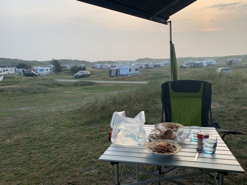
Vejers Strand Camping
First night in Denmark on a campsite in the middle of the dunes. It was wonderful.
Vejers Sydstrand 3, 6853, Vejers Strand, Dänemark
55° 37' 10.9" N 8° 7' 12" E
55.6197000 8.1200000
• Head toward Spurvevej on Vejers Sydstrand. Go for 939 m.
• Turn left onto Vejers Havvej. Go for 762 m.
• Turn right onto Risvej. Go for 284 m.
• Turn right onto Havstien. Go for 136 m.
• Arrive at Havstien. Your destination is on the left.
☍
2,1 km
( 4 min.)
Day
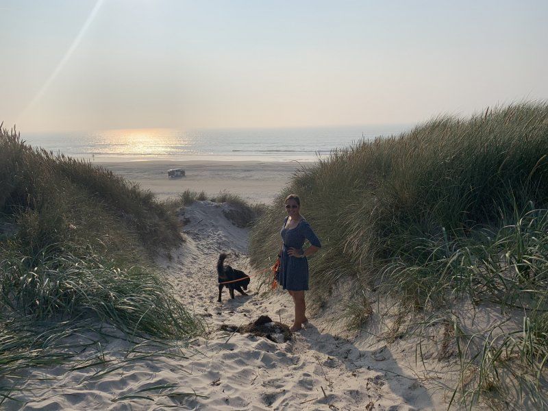
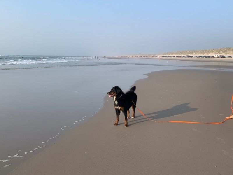
Vejers Strand, Dänemark
Strandtag. ? Sonne, Wasser, Spass pur.
6853 Vejers Strand, Dänemark
55° 37' 39.7" N 8° 7' 47.3" E
55.6277073 8.1297977
• Head toward Risvej on Havstien. Go for 136 m.
• Turn left onto Risvej. Go for 284 m.
• Turn left onto Vejers Havvej. Go for 6.9 km.
• Turn left onto Blåvandvej (431). Go for 2.5 km.
• Turn left onto Strandvejen. Go for 1.9 km.
• Turn left onto Kirkegade. Go for 888 m.
• Continue on Baunhøjvej. Go for 2.5 km.
• Continue on Troldholmvej. Go for 1.7 km.
• Continue on Jegumvej. Go for 1.8 km.
• Continue on Mønstervej. Go for 2.3 km.
• Turn left onto Strandvejen (465). Go for 5.6 km.
• Turn right onto Blåbjergvej. Go for 4.0 km.
• Turn left onto Houstrupvej. Go for 3.6 km.
• Turn left onto Vesterhavsvej (181). Go for 25.9 km.
• Pass 4 roundabouts and continue on Holmsland Klitvej (181). Go for 14.0 km.
• Take the 3rd exit from roundabout onto Søndervig Landevej (15). Go for 440 m.
• Turn right onto Houvig Klitvej (181). Go for 43.3 km.
• Turn left onto Vestermøllevej. Go for 95 m.
• Turn right onto Fjaltringbyvej. Go for 1.1 km.
• Continue on Transvej. Go for 4.0 km.
• Turn left onto Gammel Damsgårdvej. Go for 218 m.
• Keep right onto Gammel Damsgårdvej. Go for 926 m.
• Turn right onto Fyrvej. Go for 387 m.
• Arrive at Fyrvej. Your destination is on the left.
☍
124,6 km
(1 hrs. 55 min.)
Day
Bovbjerg Fyr, Fyrvej, Lemvig, Dänemark
Mittagspause. Bestaunen des Leuchtturms und der stürmischen Nordseeküste.
Fyrvej 27, 7620 Lemvig, Dänemark
56° 30' 47.5" N 8° 7' 10.7" E
56.5132023 8.1196274
• Head toward Gammel Damsgårdvej on Fyrvej. Go for 387 m.
• Turn left onto Gammel Damsgårdvej. Go for 1.1 km.
• Turn right onto Transvej. Go for 1.2 km.
• Turn left onto Pugholmvej. Go for 2.7 km.
• Continue on Rammedigevej. Go for 1.8 km.
• Continue on Strøggade. Go for 799 m.
• Continue on Lomborgvej. Go for 5.9 km.
• Turn right onto Ringkøbingvej (28). Go for 4.0 km.
• Turn left onto Vilhelmsborgvej (521). Go for 14.1 km.
• Take the 2nd exit from roundabout onto Vilhelmsborgvej (521). Go for 4.7 km.
• Take the 2nd exit from roundabout. Go for 125 m.
• Continue on Nordre Ringvej. Go for 2.4 km.
• Take the 3rd exit from roundabout onto Nordre Ringvej (O2). Go for 1.0 km.
• Take the 2nd exit from roundabout onto Nordre Ringvej (O2). Go for 7.6 km.
• Take exit 21 toward Holstebro Ø/Viborg/185/Karup Lufthavn. Go for 459 m.
• Take the 4th exit from roundabout onto Viborgvej (16). Go for 253 m.
• Pass 2 roundabouts and continue on Holstebrovej (16). Go for 40.6 km.
• Take the 3rd exit from roundabout onto Hestdalvej toward Vest 25-29/16. Go for 866 m.
• Take the 1st exit from roundabout onto Vestermarksvej. Go for 1.9 km.
• Take the 3rd exit from roundabout onto Vestre Ringvej (13/16/26) toward Aalborg/Randers/Skive. Go for 2.7 km.
• Take the 2nd exit from roundabout onto Nordre Ringvej (13/16) toward Randers/Aalborg/Viborg Ø. Go for 1.4 km.
• Take the 3rd exit from roundabout onto Aalborgvej (13) toward Aalborg. Go for 17.7 km.
• Pass 3 roundabouts and continue on Viborgvej (13). Go for 28.7 km.
• Take ramp onto E45 (Nordjyske Motorvej). Go for 34.8 km.
• Keep right onto E39 (Vendsyssel) toward Hirtshals/Hjørring/Brønderslev/Høvejen/Thisted. Go for 57.6 km.
• Take the 2nd exit from roundabout onto Aalborgvej (E39) toward Hirtshals. Go for 2.3 km.
• Take the 2nd exit from roundabout onto Aalborgvej (E39) toward Hirtshals/Havn. Go for 1.4 km.
• Keep left onto E39 toward Color Line/Check-in. Go for 739 m.
• Arrive at E39. Your destination is on the left.
☍
239,3 km
(2 hrs. 53 min.)
Hirtshals Havn, Norgeskajen, Hirtshals, Dänemark
Von hier geht's nach Kristiansand mit der schnellsten Fähre. 2h 15min mit dem Katamaran von FjordLine.
Norgeskajen 11, 9850 Hirtshals, Dänemark
57° 35' 35" N 9° 58' 6.9" E
57.5930483 9.9685764
• Head northwest on E39. Go for 44 m.
• Take the Hirtshals-Kristiansand Ferry. Stay on for 139 km.
• Head northwest. Go for 412 m.
• Continue toward Havnegata. Go for 31 m.
• Turn right onto Havnegata. Go for 794 m.
• Arrive at Havnegata. Your destination is on the left.
☍
140,2 km
(4 hrs. 2 min.)
Kristiansand
That was a very, very tough 2h 15min. With an average speed of 60km / h, the North Sea became even more stormy. Lukas still held it out to some extent, but I struggled with my stomach from the first minute. Laika thought it was funny.
Kristiansand, Norwegen
58° 8' 38.9" N 7° 59' 6.6" E
58.1441439 7.9851723
• Head east on Havnegata. Go for 190 m.
• Turn left toward Havnegata. Go for 40 m.
• Turn left onto Havnegata. Go for 390 m.
• Take the 3rd exit from roundabout toward Stavanger/E39. Go for 169 m.
• Continue on Vesterveien. Go for 56 m.
• Take ramp onto Vesterveien (E39). Go for 1.9 km.
• Take the 2nd exit from roundabout onto Fidjebakken (E39). Go for 8.2 km.
• Take the exit. Go for 383 m.
• Take the 3rd exit from roundabout. Go for 209 m.
• Take the 2nd exit from roundabout onto 439. Go for 1.9 km.
• Take the 2nd exit from roundabout onto Hølleveien (456) toward Vågsbygd/Søgne. Go for 207 m.
• Take the 3rd exit from Bergeveien roundabout onto Hølleveien (456). Go for 1.2 km.
• Continue on Hølleveien (4236). Go for 274 m.
• Take the 1st exit from Bergeveien roundabout onto Sangvikveien (479). Go for 1.6 km.
• Turn slightly right onto Eikeveien (3966). Go for 226 m.
• Arrive at Eikeveien (3966). Your destination is on the left.
☍
16,9 km
( 18 min.)
Eikeveien 174, Søgne, Norwegen
First night "Wild-Camping", a wonderful place found with Park4Night.
Eikeveien 174, 4640 Søgne, Norwegen
58° 4' 49.7" N 7° 47' 10.2" E
58.0804817 7.7861737
• Head northwest on Eikeveien (3966). Go for 1.5 km.
• Continue on 3966. Go for 14 m.
• Continue on Eikeveien (3966). Go for 332 m.
• Turn left onto Lundeveien (3975). Go for 125 m.
• Turn left onto Leireveien (3972). Go for 381 m.
• Turn right onto Bergeveien. Go for 43 m.
• Turn left onto 439. Go for 4.2 km.
• Take the 1st exit from roundabout onto Eikestølveien. Go for 143 m.
• Take the 2nd exit from roundabout onto Eikestølveien (3974). Go for 321 m.
• Take the 1st exit from roundabout onto E39. Go for 11.2 km.
• Take the exit. Go for 749 m.
• Take the 2nd exit from roundabout onto E39. Go for 180 m.
• Pass 4 roundabouts and continue on Mandalsveien (E39). Go for 21.1 km.
• Take the 1st exit from roundabout onto Mandalsveien (E39) toward Stavanger. Go for 3.2 km.
• Take the 1st exit from roundabout onto Mandalsveien (E39) toward Stavanger. Go for 8.7 km.
• Take the 1st exit from roundabout. Go for 912 m.
• Take the 1st exit from roundabout onto E39. Go for 135 km.
• Pass 3 roundabouts and continue on Sandnesveien (E39). Go for 25.9 km.
• Take the exit. Go for 237 m.
• Pass 3 roundabouts and continue on Motorveien. Go for 926 m.
• Take the 1st exit from roundabout onto Madlaveien (441) toward Sentrum/Ferje/13/Ferge Gb Dk/Turistinformasjon. Go for 433 m.
• Take the 1st exit from roundabout onto Kannikgata (441). Go for 145 m.
• Take the 3rd exit from roundabout onto Olav Vs gate (4580). Go for 254 m.
• Take the 2nd exit from roundabout onto Olav Vs gate (426). Go for 188 m.
• Take the 1st exit from roundabout onto Haakon VIIs gate (426). Go for 43 m.
• Continue on Kongsgårdbakken (426). Go for 15 m.
• Take the 1st exit from roundabout onto Haakon VIIs gate. Go for 50 m.
• Arrive at Haakon VIIs gate. Your destination is on the left.
☍
216,2 km
(2 hrs. 57 min.)
Day
Stavanger, Norwegen
After a short visit to the beautiful city of Stavanger, we took the ferry to Tau from here.
58° 58' 11.9" N 5° 43' 59.2" E
58.9699756 5.7331074
• Head southwest on Haakon VIIs gate. Go for 29 m.
• Take the 2nd exit from roundabout onto Kongsgårdbakken (426). Go for 36 m.
• Continue on Haakon VIIs gate (426). Go for 34 m.
• Take the 2nd exit from roundabout onto Olav Vs gate (426). Go for 200 m.
• Take the 1st exit from roundabout onto Olav Vs gate (4580). Go for 230 m.
• Take the 1st exit from roundabout onto Kannikgata (441). Go for 141 m.
• Take the 2nd exit from roundabout onto Madlaveien (441). Go for 442 m.
• Take the 2nd exit from roundabout onto Motorveien toward 510/Kristiansand/Sandnes/Lufthavn Sola. Go for 197 m.
• Take the 2nd exit from roundabout onto Motorveien. Go for 275 m.
• Take the 2nd exit from roundabout onto Hundvågtunnelen (13). Go for 6.3 km.
• Take the 1st exit from roundabout onto Ryfylketunnelen (13). Go for 14.9 km.
• Take the 1st exit from roundabout onto Ryfylkevegen (13). Go for 115 m.
• Pass 2 roundabouts and continue on Ryfylkevegen (523). Go for 7.2 km.
• Take the 3rd exit from roundabout onto Dalavegen (4644). Go for 1.4 km.
• Turn left onto Dalavegen (4644). Go for 2.5 km.
• Turn left onto Dalavegen. Go for 62 m.
• Arrive at Dalavegen. Your destination is on the right.
☍
34,1 km
( 35 min.)
Sekundær Fylkesveg 527 653, Jørpeland, Norwegen
A small gravel place near the pass road that runs parallel to the Preikestolen road. There we meet Denise and Oli, who travel for a whole year in their camper "Bruno" with their dog Pepsi through Europe. With Felix and Beatrix, Oli's parents, who spontaneously bought a camper to accompany their son through Scandinavia for 3 weeks. A great family! Late in the evening, the Spaniard Pedro came in, who managed the steep gravel road in his 4x4 VW California as if it were nothing.
Fv527 653, 4100 Jørpeland, Norwegen
59° 2' 9.3" N 6° 5' 51.1" E
59.0359293 6.0975395
• Head southeast on Dalavegen. Go for 62 m.
• Turn right onto Dalavegen (4644). Go for 3.9 km.
• Take the 3rd exit from roundabout onto Ryfylkevegen (523). Go for 3.7 km.
• Turn left onto Preikestolvegen (4642). Go for 5.1 km.
• Turn slightly left onto Preikestolvegen (4642). Go for 47 m.
• Arrive at Preikestolvegen (4642). Your destination is on the right.
☍
12,8 km
( 17 min.)
Day
Preikestolen fjellstue, Preikestolvegen, Jørpeland, Norwegen
At Denise and Oli's tip, we set off for the Pulpit Rock at dawn. The 4th of us drive up to the parking lot in our camper and quickly climb the 330 meters of altitude to the rock. On the route we stop again and again to marvel at the overwhelming landscape. Once at the top everything is still in the fog, but a few minutes later we are rewarded with the view over the Lysefjord and enjoy a fespa before going downhill again. Swarms of tourists come towards us in all shapes and colors who want to go up in the rain. We were lucky.
Preikestolvegen 521, 4100 Jørpeland, Norwegen
58° 59' 27.7" N 6° 8' 14.8" E
58.9910306 6.1374346
• Head north on Preikestolvegen (4642). Go for 5.1 km.
• Turn right onto Ryfylkevegen (523). Go for 3.7 km.
• Pass 4 roundabouts and continue on Ryfylkevegen (13). Go for 8.6 km.
• Turn right onto Kyrkjebakken (4650). Go for 855 m.
• Continue on Kyrkjebakken (4652). Go for 14 m.
• Continue on Monanevegen (4652). Go for 79 m.
• Turn right onto Tjøstheimsvegen (4654). Go for 2.5 km.
• Turn left onto Tjøstheimsvegen (4654). Go for 3.8 km.
• Turn right onto Ryfylkevegen (13). Go for 37.5 km.
• Take the 1st exit from roundabout onto Vågavegen (4682). Go for 454 m.
• Arrive at Vågavegen (4682).
☍
62,6 km
(1 hrs. 2 min.)
Hjelmeland, Norwegen
Here is a short ferry to Nesvik.
59° 13' 58.4" N 6° 10' 20.3" E
59.2329017 6.1722997
• Head toward Klokkarbakken on Vågavegen (4682). Go for 431 m.
• Take the 1st exit from roundabout onto 13. Go for 246 m.
• Take the Hjelmeland-Nesvik Ferry. Stay on for 3.1 km.
• Head toward Jøsnesvegen on Indre Ryfylkevegen (13). Go for 13.1 km.
• Turn right onto Jøsenfjordvegen (4702) toward Mosvatnet/Jøsenfjorden. Go for 11.2 km.
• Continue on Gullingvegen (4702). Go for 8.1 km.
• Turn left. Go for 56 m.
• Turn right. Go for 353 m.
• Arrive at your destination.
☍
36,6 km
(1 hrs. 8 min.)
Mosvatnet, Sand, Norwegen
We feel very safe when camping wild and looked for a completely secluded spot by the lake. But soon it rains incessantly and the adjacent river is slowly becoming more scary than majestic. We decide to go to a safer place shortly before going to bed and more or less flee to the next town.
Mosvatnet, Suldal, Norwegen
59° 24' 56.4" N 6° 26' 7.3" E
59.4156637 6.4353677
• Head south. Go for 353 m.
• Turn left toward Gullingvegen/4702. Go for 56 m.
• Turn left onto Gullingvegen (4702). Go for 8.7 km.
• Turn left onto Gullingvegen (4702). Go for 736 m.
• Turn right onto Suldalsvegen (13). Go for 6.3 km.
• Turn right. Go for 101 m.
• Arrive at your destination on the left.
☍
16,3 km
( 18 min.)
Prestavikjo stadion, Suldalsosen, Norwegen
The school parking lot in this lovely little town offers us refuge and we spend a quiet night before continuing north. Here we fill our provisions.
4237 Suldalsosen, Norwegen
59° 29' 16.5" N 6° 29' 35.1" E
59.4879116 6.4930761
• Head north. Go for 101 m.
• Turn right onto Suldalsvegen (13). Go for 52.4 km.
• Turn left onto Håra (E134). Go for 20.0 km.
• Turn right onto 13 toward Brimnes/Odda/550/Utne/551/48/Rosendal. Go for 3.4 km.
• Arrive at 13. Your destination is on the right.
☍
75,9 km
(1 hrs. 9 min.)
Day
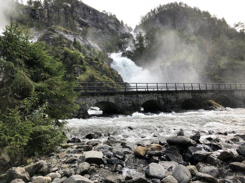
Låtefossen, R13(old), Skare, Norwegen
A photo stop at one of the most beautiful waterfalls in the region was a must.
R13(old) 7, 5763 Skare, Norwegen
59° 56' 52.2" N 6° 35' 3.3" E
59.9478293 6.5842620
• Head north on 13. Go for 14.3 km.
• Take the 1st exit from roundabout onto Røldalsvegen (13). Go for 584 m.
• Arrive at Tyssedalsvegen (13). Your destination is on the right.
☍
14,9 km
( 14 min.)
Riksveg 13, Odda, Norwegen
Here on a nice parking lot with a few other campers, lunch is served from the fridge before a few kilometers through long tunnels to Bergen.
Rv13, Odda, Norwegen
60° 4' 9.3" N 6° 33' 3.1" E
60.0692558 6.5508672
• Head toward Straumen on Tyssedalsvegen (13). Go for 77 m.
• Turn sharp left onto Tyssedalsvegen. Go for 94 m.
• Turn right onto Tyssedalsvegen (13). Go for 290 m.
• Turn right onto Eitrheimsvegen. Go for 185 m.
• Turn right onto Eitrheimsvegen. Go for 216 m.
• Take the 1st exit from roundabout onto Eitrheimsvegen (49). Go for 2.7 km.
• Take the 2nd exit from roundabout onto 49. Go for 12.5 km.
• Turn right onto 49. Go for 62 m.
• Continue on Austrepollen (49). Go for 146 m.
• Continue on 49. Go for 292 m.
• Continue on Kamrygg (49). Go for 110 m.
• Continue on 49. Go for 4.8 km.
• Continue on Nordrepollen (49). Go for 122 m.
• Continue on 49. Go for 474 m.
• Continue on Jondalstunnelen (49). Go for 10.1 km.
• Continue on 49. Go for 584 m.
• Continue on Torsnestunnelen (49). Go for 605 m.
• Continue on 49. Go for 386 m.
• Take the 1st exit from roundabout onto Belsnesvegen (49). Go for 5.4 km.
• Continue on Jonavegen (550). Go for 25 m.
• Arrive at Jonavegen (550). Your destination is on the right.
☍
39,2 km
( 37 min.)
Jondal, Norwegen
For the fourth time on our journey, we are going on a ferry, we are slowly getting to know the game: open the gap, cars out, cars in, window open, credit card in, money out, gap closed. Tucker, Tucker, Tucker. Look up, cars out, let's go on.
60° 16' 33.6" N 6° 15' 9" E
60.2760065 6.2525002
• Head toward Belsnesvegen on Jonavegen (550). Go for 25 m.
• Turn right onto 49. Go for 98 m.
• Take the Jondal-Trøvikbygd Ferry. Stay on for 5.2 km.
• Head toward Skutevik on Tørvikbygdvegen (49). Go for 191 m.
• Turn right onto Tørvikbygdvegen (49). Go for 12.7 km.
• Turn left onto Steinsdalsvegen (49). Go for 69 m.
• Take the 1st exit from roundabout onto Steinsdalsvegen (49). Go for 7.2 km.
• Continue on 7. Go for 25 m.
• Continue on 49. Go for 20.6 km.
• Take the 1st exit from roundabout onto Samnangervegen (49) toward Bergen/E16. Go for 14.3 km.
• Take the 3rd exit from roundabout onto Hardangervegen (E16). Go for 9.7 km.
• Take the 1st exit from roundabout onto Arnavegen (E16) toward Bergen Nord/E39. Go for 581 m.
• Take the 2nd exit from roundabout onto Arnavegen (E16) toward E39/Bergen/Åsane. Go for 9.9 km.
• Take the 3rd exit from roundabout onto E16/E39 (Åsaneveien) toward Bergen. Go for 12.9 km.
• Keep left toward Sentrum. Go for 128 m.
• Take left ramp onto Fjøsangerveien toward Sentrum. Go for 821 m.
• Turn left onto Fjøsangerveien toward E39/E16/Åsane/E39N/Sentrum. Go for 27 m.
• Continue on Strømgaten. Go for 79 m.
• Turn right onto Lars Hilles gate. Go for 339 m.
• Continue on Foreningsgaten. Go for 73 m.
• Continue on Vaskerelven (5334). Go for 123 m.
• Turn right onto Vaskerelvsmauet. Go for 24 m.
• Arrive at Vaskerelvsmauet. Your destination is on the right.
☍
95,0 km
(2 hrs. 2 min.)
Bergen
Bergen enttäuschte uns nicht. Mit seinen wunderschönen farbigen Häusern, der grünen Parkanlagen und dem Meer ist dies eine der schönsten Städte hier im Norden.
Torggaten 11, 5014 Bergen, Norwegen
60° 23' 28.5" N 5° 19' 19.4" E
60.3912628 5.3220544
• Head toward Vaskerelven on Vaskerelvsmauet. Go for 24 m.
• Turn right onto Vaskerelven (5334). Go for 47 m.
• Turn left onto Sigurds gate. Go for 53 m.
• Turn left onto Neumanns gate. Go for 85 m.
• Turn right onto Vestre Torggaten. Go for 76 m.
• Turn left onto Håkonsgaten (5350). Go for 76 m.
• Continue on Nygårdsgaten. Go for 76 m.
• Turn left onto Christies gate. Go for 454 m.
• Turn left onto Småstrandgaten (585). Go for 192 m.
• Turn right onto Torget (585). Go for 285 m.
• Arrive at Bryggen (585). Your destination is on the right.
☍
1,4 km
( 5 min.)
Bryggeloftet & Stuene Restaurant, Bryggen, Bergen, Norwegen
Unfortunately in Norway it is forbidden by law to take dogs into restaurants, which we had to learn at the door of such a restaurant. Our bitch was dead tired anyway and we took it calmly, so we brought Laika back to the camper, parked it as close to the restaurant as possible and enjoyed a rich and fresh dinner.
Bryggen 11, 5003 Bergen, Norwegen
60° 23' 47.3" N 5° 19' 29.1" E
60.3964640 5.3247470
• Head toward Lodin Lepps gate on Bryggen (585). Go for 285 m.
• Turn right onto Strandkaien (5347). Go for 289 m.
• Keep left onto Østre Murallmenningen (5347). Go for 119 m.
• Turn right onto Jon Smørs gate (5347). Go for 321 m.
• Turn right onto Komediebakken (5347). Go for 144 m.
• Turn left onto Nøstegaten (555). Go for 599 m.
• Keep left onto Bredalsmarken (555) toward Fyllingsdalen/Sotra/Askøy/562. Go for 197 m.
• Take ramp onto Puddefjordsbroen (5347). Go for 570 m.
• Take ramp toward Sotra/555/Damsgård. Go for 212 m.
• Turn left onto Michael Krohns gate (558) toward Sotra/555/Fyllingsdalen/540/Damsgård. Go for 47 m.
• Turn right onto Tverrveien. Go for 149 m.
• Turn left onto Damsgårdsveien. Go for 491 m.
• Turn right. Go for 44 m.
• Arrive at your destination on the left.
☍
3,5 km
( 8 min.)
Damsgårdsveien 175, 5160 Bergen, Norwegen
We spent the night here in a free car park 10 minutes by car from the city center. Rather quiet with a direct view of the harbor.
60° 23' 10.7" N 5° 18' 6.2" E
60.3863017 5.3017337
• Head toward Damsgårdsveien. Go for 44 m.
• Turn left onto Damsgårdsveien. Go for 491 m.
• Turn right onto Tverrveien. Go for 144 m.
• Turn left onto Michael Krohns gate (558). Go for 236 m.
• Take ramp onto Puddefjordsbroen (5347) toward 555/Sentrum. Go for 1.6 km.
• Take left ramp onto Fjøsangerveien toward Sentrum. Go for 998 m.
• Turn left onto Fjøsangerveien toward E39/E16/Åsane/E39N/Sentrum. Go for 27 m.
• Continue on Strømgaten. Go for 79 m.
• Turn right onto Lars Hilles gate. Go for 339 m.
• Continue on Foreningsgaten. Go for 73 m.
• Continue on Vaskerelven (5334). Go for 123 m.
• Turn right onto Vaskerelvsmauet. Go for 24 m.
• Arrive at Vaskerelvsmauet. Your destination is on the right.
☍
4,2 km
( 8 min.)
Day
Bergen, Norwegen
Souvenir shopping and photography in Bergen. After a waffle for lunch, we head north for the last time.
60° 23' 28.5" N 5° 19' 19.4" E
60.3912628 5.3220544
• Head toward Vaskerelven on Vaskerelvsmauet. Go for 24 m.
• Turn right onto Vaskerelven (5334). Go for 47 m.
• Turn left onto Sigurds gate. Go for 53 m.
• Turn left onto Neumanns gate. Go for 85 m.
• Turn right onto Vestre Torggaten. Go for 76 m.
• Turn left onto Håkonsgaten (5350). Go for 76 m.
• Continue on Nygårdsgaten. Go for 394 m.
• Turn left onto Strømgaten. Go for 140 m.
• Turn right onto Lars Hilles gate. Go for 147 m.
• Continue on Bjørns gate. Go for 15 m.
• Turn right onto Bjørns gate. Go for 15 m.
• Continue on Fjøsangerveien. Go for 302 m.
• Take left ramp onto Åsaneveien (E16/E39) toward Åsane/Ferge Skolten. Go for 12.8 km.
• Continue on E39. Go for 13.7 km.
• Pass 2 roundabouts and continue on Osterfjordvegen (E39). Go for 446 m.
• Turn right onto Osterfjordvegen (E39). Go for 100 m.
• Take the 2nd exit from roundabout onto Osterfjordvegen (E39). Go for 143 m.
• Continue on Haugvegen (E39). Go for 80.1 km.
• Take the Oppedal-Lavik Ferry. Stay on for 5.6 km.
• Head toward Hellebøstranda on E39. Go for 59.2 km.
• Pass 3 roundabouts and continue on Brulandsvegen (E39). Go for 43.1 km.
• Take the 2nd exit from roundabout onto Jølstravegen (E39) toward Ålesund/Nordfjordeid. Go for 19.9 km.
• Turn right onto Fjellvegen (60) toward Stryn. Go for 40.7 km.
• Turn right onto Sjøatunet. Go for 246 m.
• Turn slightly right onto 5724. Go for 1.0 km.
• Continue on Oldedalsvegen (5724). Go for 497 m.
• Continue on 5724. Go for 1.5 km.
• Continue on Solheim (5724). Go for 95 m.
• Continue on 5724. Go for 463 m.
• Continue on Oldedalsvegen (5724). Go for 3.2 km.
• Continue on 5724. Go for 2.1 km.
• Continue on 5724. Go for 931 m.
• Turn right. Go for 65 m.
• Turn left. Go for 47 m.
• Arrive at your destination on the left.
☍
287,3 km
(4 hrs. 52 min.)
Oldevatn Camping
The way was worth it! After a winding drive and many photo and drone stops for Lukas, we arrived shortly before 8 at the wonderful campsite directly below the glacier. We will definitely stay here for 2 nights, maybe even more ... the warm welcome completes the picture of this campsite.
6788, Olden, Norwegen
61° 45' 31" N 6° 48' 42.8" E
61.7586000 6.8119000
• Head southwest.
• Arrive at your destination on the left.
☍
Distance not available
(Duration not available)
Day
Oldevatn Camping
Of course we had to use the free rental of canoes and on our lazy day we took a little trip over the Oldevatnet.
6788, Olden, Norwegen
61° 45' 31" N 6° 48' 42.8" E
61.7586000 6.8119000
• Head northeast. Go for 47 m.
• Turn right toward 5724. Go for 65 m.
• Turn right onto 5724. Go for 6.6 km.
• Turn slightly left onto Oldedalsvegen (5724). Go for 882 m.
• Continue on 5724. Go for 181 m.
• Continue on Oldedalsvegen (5724). Go for 660 m.
• Continue on 5724. Go for 3.2 km.
• Turn slightly left onto 5724. Go for 408 m.
• Continue on Briksdalen (5724). Go for 73 m.
• Arrive at Briksdalen (5724).
☍
12,1 km
( 17 min.)
Day
Briksdalsbreen, Briksdalsbre, Norwegen
Today was a bigger hike on the plan. The Kattanakken, which translates as "cats neck", should be conquered over an altitude of 1300 meters. We got up despite the rain and were very happy. But the route led early over smooth, completely wet rock ridges where there was no stop. In this weather actually insurmountable. We stayed sensible and decided on a photo and drone session, where we had already done a few meters in altitude. 1-0 for the cat.
Briksdalsbreen, Stryn, Norwegen
61° 39' 57.7" N 6° 53' 24.7" E
61.6660182 6.8902016
• Head northwest on Briksdalen (5724). Go for 73 m.
• Continue on 5724. Go for 246 m.
• Turn slightly left onto 5724. Go for 3.4 km.
• Continue on Oldedalsvegen (5724). Go for 660 m.
• Continue on 5724. Go for 181 m.
• Continue on Oldedalsvegen (5724). Go for 882 m.
• Turn slightly right onto 5724. Go for 6.6 km.
• Turn left. Go for 65 m.
• Turn left. Go for 47 m.
• Arrive at your destination on the left.
☍
12,1 km
( 17 min.)
Oldevatn Camping
One last time we treat ourselves to the great facilities of this neat camping site before we head back to the streets tomorrow.
6788, Olden, Norwegen
61° 45' 31" N 6° 48' 42.8" E
61.7586000 6.8119000
• Head northeast. Go for 47 m.
• Turn right toward 5724. Go for 65 m.
• Turn left onto 5724. Go for 3.1 km.
• Continue on Oldedalsvegen (5724). Go for 3.2 km.
• Continue on 5724. Go for 463 m.
• Continue on Solheim (5724). Go for 95 m.
• Continue on 5724. Go for 1.5 km.
• Continue on Oldedalsvegen (5724). Go for 497 m.
• Continue on 5724. Go for 1.3 km.
• Turn right onto 60. Go for 16.6 km.
• Take the 1st exit from roundabout onto Tonningsgata (15). Go for 51.2 km.
• Turn left onto 63 toward Geiranger. Go for 7.4 km.
• Turn right toward Nibbevegen. Go for 88 m.
• Continue on Nibbevegen. Go for 4.6 km.
• Arrive at Nibbevegen. Your destination is on the right.
☍
90,0 km
(1 hrs. 35 min.)
Day
Dalsnibba utsiktspunkt, Geiranger, Norwegen
Very high vantage point. Saved us the drive to Geiranger and so we could go straight to the long way to Lillehammer.
6216 Geiranger, Norwegen
62° 2' 56.4" N 7° 16' 12.5" E
62.0489958 7.2701410
• Head east on Nibbevegen. Go for 4.7 km.
• Turn left onto Geirangervegen (63). Go for 7.4 km.
• Turn left onto 15. Go for 72.5 km.
• Take the 2nd exit from roundabout onto Bergomsvegen (15) toward Otta. Go for 30.4 km.
• Pass 3 roundabouts and continue on 15. Go for 31.0 km.
• Turn right onto E6. Go for 107 km.
• Take ramp toward 216/Sjusjøen/Lillehammer. Go for 425 m.
• Take the 2nd exit from roundabout onto Mesnadalsvegen. Go for 1.0 km.
• Turn right onto Brufoss gate (213). Go for 54 m.
• Turn left onto Kirkegata. Go for 38 m.
• Turn right onto Bankgata. Go for 193 m.
• Turn left onto Petter Nilssens gate. Go for 142 m.
• Turn left onto Jernbanegata. Go for 55 m.
• Arrive at Jernbanegata. Your destination is on the right.
☍
254,6 km
(3 hrs. 30 min.)
Lillehammer, Norwegen
Very neat little town that still lives from the '94 Olympics. We shopped some outdoor clothing and went to see the ski jump. We spent the night in the very close, free parking lot at the Olympic halls. Thanks again to Park4Night.
61° 6' 55" N 10° 27' 58.4" E
61.1152713 10.4662306
• Head west on Jernbanegata. Go for 140 m.
• Turn left onto Kirkegata. Go for 119 m.
• Turn right toward Kirkegata. Go for 54 m.
• Turn right onto Kirkegata. Go for 17 m.
• Turn right onto Brufoss gate (213). Go for 54 m.
• Turn left onto Mesnadalsvegen. Go for 977 m.
• Take the 1st exit from roundabout onto E6 toward Oslo. Go for 5.3 km.
• Take the 2nd exit from roundabout onto E6. Go for 21.9 km.
• Take the 3rd exit from roundabout onto Mjøsbrua (E6) toward Oslo/Hamar. Go for 121 km.
• Continue on E6. Go for 12.1 km.
• Take exit 45 toward Nannestad/Lillestrøm/Skedsmokorset/Gjerdrum. Go for 313 m.
• Take the 1st exit from roundabout onto Presthagaveien (120) toward Lillestrøm. Go for 275 m.
• Take the 2nd exit from roundabout onto Kirkeveien (120). Go for 2.7 km.
• Take the 3rd exit from roundabout onto Kirkeveien (120). Go for 676 m.
• Take the 2nd exit from roundabout onto Kirkeveien (120). Go for 206 m.
• Take the 2nd exit from roundabout onto Fetveien (22/120). Go for 901 m.
• Pass 3 roundabouts and continue on Fetveien (22). Go for 1.5 km.
• Take the 2nd exit from roundabout onto Fetveien (22) toward Fetsund. Go for 2.2 km.
• Pass 3 roundabouts and continue on Fetveien (22). Go for 5.2 km.
• Take the 1st exit from roundabout onto Fetveien (22) toward Mysen/169/Løken. Go for 6.0 km.
• Pass 2 roundabouts and continue on Håkon Håkonssons vei (129). Go for 37.9 km.
• Take the 2nd exit from roundabout onto E18 toward Stokholm. Go for 29.2 km.
• Continue on E18. Go for 61.0 km.
• Turn right toward Åmål/Svaneholm. Go for 643 m.
• Continue on Kettilsbyn Hagbacken. Go for 4.2 km.
• Continue on Hallanda Stationen. Go for 2.0 km.
• Continue on Strand Solhem. Go for 731 m.
• Continue on Strandvägen. Go for 609 m.
• Turn right onto Storgatan. Go for 2.8 km.
• Continue on Södra Skarbol Svanvik. Go for 4.7 km.
• Continue on Mo Kroken. Go for 2.4 km.
• Continue on Persbyn. Go for 1.6 km.
• Continue on Mo Byn. Go for 1.3 km.
• Turn right onto Mo Stom. Go for 1.1 km.
• Turn right onto Fåfängan. Go for 2.0 km.
• Turn right onto Kallskog. Go for 143 m.
• Continue on Mo Sandviken. Go for 174 m.
• Turn left onto Mo Sandviken. Go for 763 m.
• Continue on Persbyn. Go for 641 m.
• Arrive at Persbyn. Your destination is on the left.
☍
335,2 km
(4 hrs. 5 min.)
Day
Nedre Kalven, Schweden
Without a break, with a fist loaf in hand, we rattled down kilometer after kilometer to find a cozy place in apparently dry and warmer Sweden.
Somewhere in the middle of nowhere by an unknown lake, we found the purest peace. It was quiet, dry, a few rays of sunshine and the view over the lake. We felt comfortable here and were able to recharge our batteries for further adventures.
Unnamed Road, 662 91 Åmål, Schweden
59° 6' 48.6" N 12° 35' 38.1" E
59.1134906 12.5939203
• Head toward Mo Sandviken on Persbyn. Go for 641 m.
• Continue on Mo Sandviken. Go for 763 m.
• Turn right onto Mo Sandviken. Go for 174 m.
• Continue on Kallskog. Go for 143 m.
• Turn left onto Fåfängan. Go for 402 m.
• Turn slightly right toward Kallskog. Go for 49 m.
• Continue on Kallskog. Go for 1.3 km.
• Turn slightly left onto Forsbacka. Go for 82 m.
• Continue toward Forsbacka. Go for 141 m.
• Turn slightly right onto Forsbacka. Go for 60 m.
• Turn right toward 164. Go for 887 m.
• Turn right onto 164. Go for 25.4 km.
• Turn left onto 164/172 toward Strömstad/Uddevalla/Billingsfors. Go for 27.7 km.
• Turn right onto 172. Go for 34.3 km.
• Turn right onto Dagsholm. Go for 1.9 km.
• Continue on Ellenö. Go for 187 m.
• Continue on Torp. Go for 181 m.
• Continue on Torp. Go for 106 m.
• Continue on Torps prästgård. Go for 113 m.
• Continue on Ellenö. Go for 92 m.
• Continue on Torps skola. Go for 134 m.
• Continue on Torp. Go for 1.2 km.
• Continue on Friskekullen. Go for 200 m.
• Turn left onto Ottersbyn. Go for 6.2 km.
• Turn right toward Tostane. Go for 605 m.
• Continue on Tostane. Go for 443 m.
• Continue on Tostane. Go for 2.8 km.
• Turn left toward Soterud. Go for 1.3 km.
• Continue on Soterud. Go for 571 m.
• Turn left. Go for 5.8 km.
• Arrive at your destination on the left.
☍
113,9 km
(1 hrs. 49 min.)
Day
Vrängevattnet, Schweden
We wanted to hike! Or I really wanted to hike, I've been trying to incorporate a longer hike into our trip for days, but so far either the location or the weather have simply not played along. So come on the fuck out, I found a hiking area on our route today. Said and done. We were 4km in the purest jungle without any view, from the middle we only had to be allowed to walk on a street, which we had done on the last 2km. This region may look beautiful and the hiking trails on the map promise versatility, but it was really nothing that we as Swiss would call hiking. A little discouraged and sweaty, we decided on a campsite with showers and a nice atmosphere for the night.
Unnamed Road, 451 94 Uddevalla, Schweden
58° 24' 48.3" N 11° 50' 30.2" E
58.4134082 11.8417320
• Head south. Go for 3.6 km.
• Turn slightly right onto Herrestadsfjället. Go for 1.6 km.
• Continue on Herrestads Funkeröd. Go for 537 m.
• Continue toward Herrestadsfjället. Go for 490 m.
• Continue on Herrestadsfjället. Go for 954 m.
• Continue on Majorebergsvägen. Go for 524 m.
• Turn right onto Majorebergsvägen. Go for 148 m.
• Keep right onto Torpvägen. Go for 504 m.
• Turn slightly left onto Torpvägen. Go for 41 m.
• Continue toward 44. Go for 205 m.
• Continue on 44. Go for 241 m.
• Take the 2nd exit from roundabout onto 44 toward E6/Göteborg/Lysekil/160/Orust/Tjörn. Go for 352 m.
• Take the 1st exit from roundabout onto E6 toward Göteborg. Go for 34.8 km.
• Take exit 91 toward Tjörn/160/Orust/Stenungsund C onto 170. Go for 689 m.
• Take ramp toward Tjörn Orust/160/Ucklum. Go for 273 m.
• Turn right onto Ucklumsvägen. Go for 4.0 km.
• Turn right onto Göteborgsvägen. Go for 229 m.
• Continue on Nösnäsmotet. Go for 41 m.
• Turn left onto Nösnäsmotet. Go for 31 m.
• Take ramp onto 160. Go for 4.1 km.
• Turn left onto 169. Go for 2.7 km.
• Take the 2nd exit from roundabout onto 169. Go for 2.9 km.
• Take the 1st exit from roundabout onto Spjärr. Go for 1.5 km.
• Continue on Kållekärr. Go for 638 m.
• Continue toward Kållekärr. Go for 334 m.
• Continue on Kållekärr. Go for 1.3 km.
• Continue on Hällervägen. Go for 1.0 km.
• Take the 2nd exit from roundabout. Go for 240 m.
• Continue on Hogadal. Go for 1.1 km.
• Continue on Sibräckavägen. Go for 1.1 km.
• Continue on Grinneröd. Go for 908 m.
• Take the 2nd exit from roundabout. Go for 251 m.
• Continue on Siröd. Go for 722 m.
• Continue on Märkesten. Go for 641 m.
• Continue on Nordvik. Go for 630 m.
• Continue on Bö Dampegård. Go for 268 m.
• Continue on Bö Berg. Go for 1.0 km.
• Continue on Röavallen. Go for 131 m.
• Turn left. Go for 20 m.
• Arrive at your destination on the right.
☍
70,9 km
(1 hrs. 8 min.)
Havologi
Oh, that's good! Once again we have found exactly the right place for the night. This wonderful campsite is right on an archipelago island. Relatively small with a great walk to the sea, clean sanitary facilities and a spacious kitchen. All the neighbors are very helpful and we start talking immediately everywhere.
Röavallen 1, 47195, Skärmahn, Schweden
57° 58' 13.4" N 11° 33' 15.1" E
57.9704000 11.5542000
• Head south. Go for 50 m.
• Turn right toward Röavallen. Go for 30 m.
• Turn right onto Röavallen. Go for 929 m.
• Continue on Bö Berg. Go for 443 m.
• Continue on Bö Dampegård. Go for 102 m.
• Continue on Nordvik. Go for 630 m.
• Continue on Märkesten. Go for 1.3 km.
• Continue on Siröd. Go for 277 m.
• Take the 1st exit from roundabout. Go for 85 m.
• Continue on Grinneröd. Go for 1.2 km.
• Continue on Sibräckavägen. Go for 1.1 km.
• Continue on Hogadal. Go for 1.0 km.
• Take the 2nd exit from roundabout onto Hällervägen. Go for 2.0 km.
• Continue on Kållekärr. Go for 701 m.
• Continue on Kållekärr. Go for 1.9 km.
• Continue on Spjärr. Go for 223 m.
• Take the 3rd exit from roundabout onto 169. Go for 3.0 km.
• Take the 2nd exit from roundabout onto 169. Go for 2.7 km.
• Turn right onto 169. Go for 62 m.
• Continue on 160. Go for 2.9 km.
• Keep right onto 160. Go for 5.6 km.
• Take ramp onto E6 toward Göteborg. Go for 38.6 km.
• Keep left onto E6 (Olskroksmotet). Go for 150 m.
• Continue on E20 (Olskroksmotet). Go for 213 km.
• Continue on E6/E20 (Trafikplats Helsingborg S). Go for 49.0 km.
• Take exit 18 toward Malmö onto E22.10 (Stockholmsvägen). Go for 4.0 km.
• Continue on Stockholmsvägen toward Centrum. Go for 2.7 km.
• Turn right toward Stockholmsvägen. Go for 72 m.
• Continue on Stockholmsvägen. Go for 70 m.
• Continue on Hornsgatan. Go for 277 m.
• Turn slightly left onto Drottninggatan. Go for 1.2 km.
• Turn right onto Amiralsgatan toward Gustav Adolfs torg. Go for 115 m.
• Continue on Studentgatan. Go for 96 m.
• Continue on Djäknegatan. Go for 103 m.
• Turn left onto Baltzarsgatan. Go for 47 m.
• Arrive at Baltzarsgatan. Your destination is on the right.
☍
336,2 km
(3 hrs. 26 min.)
Day
Malmö, Schweden
55° 36' 17.9" N 13° 0' 13.8" E
55.6049810 13.0038220
• Head toward Kalendegatan on Baltzarsgatan. Go for 46 m.
• Turn left onto Kalendegatan. Go for 119 m.
• Turn left onto Stora nygatan. Go for 90 m.
• Turn right onto Studentgatan. Go for 96 m.
• Continue on Amiralsgatan. Go for 1.5 km.
• Turn right onto Nobelvägen. Go for 1.2 km.
• Continue on Trelleborgsvägen toward E6/E20/Trelleborg/Köpenhamn. Go for 2.7 km.
• Continue on E6.1 (Trelleborgsvägen). Go for 364 m.
• Take the exit toward Flygplats/Köpenhamn onto E20 (Yttre Ringvägen). Go for 13.9 km.
• Continue on E20 (Øresundsbroen). Go for 14.4 km.
• Take exit 18 toward Tårnby/Dragør. Go for 400 m.
• Turn right onto Englandsvej toward København. Go for 385 m.
• Take the 2nd exit from roundabout onto Englandsvej toward København/Sundby. Go for 1.1 km.
• Turn left onto Vejlands Allé toward E20/E47/Odense/Centrum. Go for 444 m.
• Turn right onto Røde Mellemvej toward Centrum. Go for 1.4 km.
• Continue on Amagerfælledvej. Go for 1.3 km.
• Turn left onto Amager Boulevard toward Centrum. Go for 982 m.
• Continue on Langebro. Go for 259 m.
• Continue on H. C. Andersens Boulevard. Go for 822 m.
• Arrive at Rådhuspladsen. Your destination is on the right.
☍
41,6 km
( 43 min.)
Kopenhagen, Dänemark
Copenhagen is very nice to look at. Even when it rains, it has not lost its charm. The many green spaces on the outskirts of the city are unique. For dinner there were waffles and crepes from one of the many stands.
55° 40' 33.9" N 12° 34' 6" E
55.6760968 12.5683372
• Head toward Studiestræde on Rådhuspladsen. Go for 329 m.
• Make a U-Turn at Jarmers Plads onto H. C. Andersens Boulevard. Go for 1.0 km.
• Turn right onto Rysensteensgade toward Lufthavn/E20/O2/21/Bella Center. Go for 72 m.
• Turn left onto Puggaardsgade toward 21/O2/Lufthavn/E20/Bella Center. Go for 139 m.
• Turn right onto Kalvebod Brygge (O2). Go for 3.0 km.
• Continue on Scandiagade toward Malmø/E20/Lufthavn/Odense/E47/Bella Center. Go for 372 m.
• Continue on Sydhavnsgade. Go for 510 m.
• Continue on Sjællandsbroen. Go for 881 m.
• Keep right onto Centrumforbindelsen toward Odense/E20/E47/E55/Malmø/Lufthavn. Go for 793 m.
• Take left ramp onto E20 (Amagermotorvejen) toward Odense/E47/E55/21. Go for 35.7 km.
• Keep right onto E47/E55 (Køge Vest) toward Rødby/Gedser. Go for 77.6 km.
• Continue on E47 (Sydmotorvejen) toward Rødby. Go for 44.4 km.
• Take the Rødby-Puttgarden Ferry. Stay on for 18.7 km.
• Head southwest on E47. Go for 865 m.
• Continue on B207. Go for 21.3 km.
• Continue on A1. Go for 21.9 km.
• Take exit 12 toward Lensahn/Schönwalde a.B./Cismar. Go for 385 m.
• Turn left onto Bäderstraße (L58) toward Lensahn/Schönwalde a.B. Go for 6.8 km.
• Turn right onto Bäderstraße (B501). Go for 5.0 km.
• Turn left onto Brookgang. Go for 544 m.
• Take the 3rd exit from roundabout onto Schützenstraße. Go for 353 m.
• Turn right onto Schützenstraße. Go for 244 m.
• Turn left onto Stettiner Straße. Go for 86 m.
• Turn slightly right onto Blankwasserweg. Go for 113 m.
• Continue on Kurpromenade. Go for 31 m.
• Turn left onto Kurpromenade. Go for 106 m.
• Arrive at Kurpromenade.
☍
241,3 km
(3 hrs. 30 min.)
Day
Hundestrand Grömitz, Kurpromenade, Grömitz, Deutschland
Simply ingenious when the hairy companion can romp around in the water with many other well-socialized dogs without a leash. The place is highly recommended, even if Grömitz itself is very taken with the German tourists and that makes for a little culture shock to Scandinavia.
Kurpromenade, 23743 Grömitz, Deutschland
54° 9' 1.7" N 10° 58' 49.8" E
54.1504669 10.9805121
• Head west on Kurpromenade. Go for 106 m.
• Turn right onto Kurpromenade. Go for 31 m.
• Continue on Blankwasserweg. Go for 113 m.
• Turn sharp right onto Stettiner Straße. Go for 59 m.
• Turn left onto Freienwalder Straße. Go for 172 m.
• Turn left onto Blankwasserweg. Go for 22 m.
• Turn right onto Kieler Straße. Go for 296 m.
• Turn right onto Mittelweg. Go for 1.5 km.
• Turn right onto Lenster Weg. Go for 336 m.
• Turn slightly right onto Blankwasserweg. Go for 107 m.
• Turn left. Go for 19 m.
• Arrive at your destination on the left.
☍
2,8 km
( 6 min.)
Stellplatz Lensterstrand
There is no free standing here. So use the cheapest (!) Parking space for 10 EUR including toilet. But right on the beach and the bakery within walking distance.
Blankwasserweg 104, 23743, Grömitz, Deutschland
54° 9' 20" N 10° 59' 25" E
54.1555556 10.9902778
• Head toward Blankwasserweg. Go for 19 m.
• Turn right onto Blankwasserweg. Go for 107 m.
• Turn slightly left onto Lenster Weg. Go for 336 m.
• Turn left onto Mittelweg. Go for 1.8 km.
• Turn right onto Brookgang. Go for 362 m.
• Turn left onto Mühlenstraße (B501). Go for 539 m.
• Turn right onto Neustädter Straße (B501). Go for 10.1 km.
• Take ramp onto A1 toward Lübeck. Go for 95.0 km.
• Take the left exit toward Bremen/Hannover/HH-Stillhorn onto A1. Go for 15.2 km.
• Continue on Horster Dreieck toward Hannover/Seevetal-Ramelsloh/A7. Go for 1.7 km.
• Continue on A7. Go for 242 km.
• Take exit 73 toward Dransfeld. Go for 280 m.
• Turn left onto Dransfelder Straße (B3) toward Kassel/Dransfeld. Go for 8.3 km.
• Pass 2 roundabouts and continue on Mündener Straße (B3). Go for 14.7 km.
• Turn right onto B3/B80 toward A7/Kassel/Höxter/Bad Karlshafen/Stadtmitte/Zentrum/Krankenhäuser. Go for 9.1 km.
• Turn right onto K40 toward Knickhagen. Go for 369 m.
• Continue on Untermühle (K40). Go for 303 m.
• Continue on K40. Go for 302 m.
• Continue on Osterbachstraße (K40). Go for 163 m.
• Turn left onto Sudholzstraße. Go for 45 m.
• Turn slightly right onto Sudholzstraße. Go for 116 m.
• Turn slightly right toward Fulda-Freizeitzentrum. Go for 372 m.
• Turn left onto Fulda-Freizeitzentrum. Go for 208 m.
• Arrive at Fulda-Freizeitzentrum. Your destination is on the right.
☍
400,9 km
(4 hrs. 7 min.)
Day
Campingplatz Fulda-Freizeitzentrum
Today we picked up the car at the rental and then quietly at the last campsite to make the camper suitable for delivery and to load a lot again. Here on the Fulda everything is still okay and we are only allowed to start the engines at 7:00 am, which suits us well, so we get up with the sun again on the last day.
FULDA FREIZEITZENTRUM 1, 34233, Fuldatal-Knickhagen, Deutschland
51° 24' 2.9" N 9° 32' 54.6" E
51.4008000 9.5485000
• Head southeast on Fulda-Freizeitzentrum. Go for 208 m.
• Turn right toward Sudholzstraße. Go for 372 m.
• Turn slightly left onto Sudholzstraße. Go for 161 m.
• Turn right onto Osterbachstraße (K40). Go for 60 m.
• Turn right onto Erlenbuschstraße. Go for 1.2 km.
• Continue on Am Fliegerhorst. Go for 267 m.
• Continue on Sonnenallee. Go for 613 m.
• Continue on K41. Go for 1.6 km.
• Turn left onto Rothwestener Straße (L3232). Go for 1.2 km.
• Turn right onto Veckerhagener Straße (B3). Go for 1.9 km.
• Turn right onto L3234 toward Vellmar/Ful.-Ihringshausen-Mitte. Go for 122 m.
• Turn right onto Arwed-Hahn-Straße. Go for 28 m.
• Arrive at Arwed-Hahn-Straße. Your destination is on the right.
☍
7,8 km
( 10 min.)
Day
Windisch Wohnmobile, Arwed-Hahn Straße, Fuldatal, Deutschland
Delivery of our motorhome, with a few thousand kilometers more than promised, the vehicle was sold immediately after our arrival.
Arwed-Hahn Straße 2, 34233 Fuldatal, Deutschland
51° 21' 9.8" N 9° 30' 53.9" E
51.3527280 9.5149750
• Head toward Niedervellmarsche Straße on Arwed-Hahn-Straße. Go for 28 m.
• Turn left onto L3234. Go for 122 m.
• Turn right onto B3. Go for 3.6 km.
• Turn left onto Ysenburgstraße toward Eisenach/B7/Bebra/B83. Go for 502 m.
• Turn slightly left onto Scharnhorststraße (B7/B83) toward Eisenach/Bebra. Go for 507 m.
• Keep left onto Scharnhorststraße (B7/B83) toward Gewerbegebiet Miramstraße. Go for 90 m.
• Turn left onto Dresdener Straße (L3237). Go for 3.0 km.
• Take ramp onto A7 toward Frankfurt/Würzburg/Dortmund. Go for 65.7 km.
• Keep right onto A7 (Hattenbacher Dreieck) toward München/Stuttgart/Würzburg/Fulda/Basel/Frankfurt/Wiesbaden/Gießen. Go for 131 km.
• Take exit 101 toward Würzburg/Estenfeld/Rimpar onto B19. Go for 6.4 km.
• Keep left onto B19 toward Frankfurt/Stuttgart/Ansbach/B13/Schwäbisch Hall/Stadtring-Süd/Uni-Hubland. Go for 6.6 km.
• Take ramp onto A3 toward Frankfurt/Stuttgart. Go for 6.1 km.
• Take exit 69 toward Stuttgart/Heilbronn/Tauberbischofsheim onto A81. Go for 134 km.
• Take the left exit toward München/Singen/Stuttgart/Flughafen/Messe onto A8. Go for 7.7 km.
• Take exit 51 toward Singen/Böblingen/Sindelfingen onto A81. Go for 144 km.
• Keep left onto A81 toward Schaffhausen/Bietingen. Go for 69 m.
• Take the 1st exit from roundabout onto B34 toward Schaffhausen/Bietingen. Go for 2.0 km.
• Continue on E41/E54. Go for 992 m.
• Continue on A4 toward SH-Herblingen. Go for 7.1 km.
• Keep left onto A4 toward Zürich/Rheinfall/Schaffhausen-Süd. Go for 24.4 km.
• Take exit 70 toward Zürich/Wülflingen onto A1/A4. Go for 22.0 km.
• Take exit 63 toward Bülach/Flughafen onto Dreieck Zürich-Nord. Go for 871 m.
• Continue on A51. Go for 829 m.
• Take exit 8 toward Kloten. Go for 352 m.
• Turn right onto Schaffhauserstrasse (4) toward Kloten. Go for 192 m.
• Turn left onto Balz-Zimmermann-Strasse. Go for 694 m.
• Take the 1st exit from roundabout onto Werftstrasse. Go for 398 m.
• Turn left onto Neubrunnenstrasse. Go for 73 m.
• Arrive at Neubrunnenstrasse. Your destination is on the left.
☍
569,8 km
(5 hrs. 28 min.)
Neubrunnenstrasse 25, Kloten, Schweiz
Neubrunnenstrasse 25, 8302 Kloten, Schweiz
47° 26' 43.7" N 8° 34' 31.3" E
47.4454786 8.5753637