Once to the Arctic Circle
from Northern Germany to Sweden-Finland-Sweden and back
Report is not yet complete. Will continue to be processed for the next few days.
Day
1 Tag, Freitag Etappenlänge ca. 429 km
On Friday noon we drove off with our LMC and two dogs full of joy.
On the exciting journey to the Arctic Circle. Let's see what's waiting for us ...
Schortens, Deutschland
Start time around 12 noon in bright sunshine
26 °
26419 Schortens, Deutschland
53° 32' 17.2" N 7° 56' 39.3" E
53.5381133 7.9442591
• Head toward Marienburger Straße on Elsa-Brändström-Straße. Go for 233 m.
• Turn left onto Menkestraße. Go for 385 m.
• Turn left onto Alte Ladestraße. Go for 185 m.
• Turn slightly right onto Bahnhofstraße. Go for 253 m.
• Turn right onto An der Alten Bundesstraße toward A29/Oldenburg/Wilhelmshaven/B210. Go for 561 m.
• Continue on Oldenburger Straße. Go for 878 m.
• Take the 3rd exit from roundabout onto K95 toward Oldenburg/A29/Aurich/Wilhelmshaven/B210. Go for 259 m.
• Take the 1st exit from roundabout onto K95. Go for 268 m.
• Take ramp onto B210 toward A29/Oldenburg/Wilhelmshaven. Go for 2.7 km.
• Take ramp onto A29 toward Oldenburg. Go for 19.7 km.
• Take exit 9 toward Varel/Obenstrohe/Altjührden. Go for 354 m.
• Turn left onto Wiefelsteder Straße (L819) toward Nordenham/Jaderberg/Varel. Go for 452 m.
• Take the 2nd exit from roundabout onto Wiefelsteder Straße (L819) toward Varel. Go for 941 m.
• Turn right onto Tweehörnweg. Go for 1.1 km.
• Take the 1st exit from roundabout onto Bürgermeister-Heidenreich-Straße (B437) toward Nordenham. Go for 15.7 km.
• Turn right onto Kötermoorer Straße (L855) toward Ovelgönne. Go for 1.5 km.
• Turn left onto Kötermoorer Straße. Go for 910 m.
• Turn left onto Kötermoorer Straße. Go for 116 m.
• Arrive at Kötermoorer Straße.
☍
46,5 km
( 39 min.)
Kötermoorer Str. 21, 26936 Stadland, Deutschland
53° 23' 29.2" N 8° 22' 11.3" E
53.3914330 8.3697989
• Head south on Kötermoorer Straße. Go for 116 m.
• Turn right onto Kötermoorer Straße. Go for 910 m.
• Turn right onto Kötermoorer Straße (L855). Go for 1.5 km.
• Turn right onto Schweier Straße (B437). Go for 5.2 km.
• Take ramp onto B212 toward Bremen/A27/Cuxhaven/Nordenham/Rodenkirchen. Go for 4.0 km.
• Take ramp onto B437 toward Bremen/A27/Cuxhaven/Stotel. Go for 9.9 km.
• Take ramp onto A27 toward Cuxhaven/Bremerhaven. Go for 21.8 km.
• Take exit 5 toward Debstedt/Langen/Wremen/Bad Bederkesa. Go for 389 m.
• Turn right onto L120 toward Bederkesa/Drangstedt. Go for 10.5 km.
• Take the 1st exit from roundabout onto L119 toward Bremervörde/Beverstedt. Go for 1.6 km.
• Pass 2 roundabouts and continue on L119. Go for 21.2 km.
• Turn left onto Große Straße (B495). Go for 19.7 km.
• Turn left onto Birkenstraße (K12) toward Oederquart/Neulandermoor. Go for 2.5 km.
• Turn right onto Moorchaussee (K13). Go for 1.6 km.
• Turn left onto Stader Straße (B495). Go for 1.2 km.
• Turn right onto Glückstädter Straße (B495) toward Glückstadt/Elbfähre. Go for 892 m.
• Arrive at Glückstädter Straße (B495).
☍
103,0 km
(1 hrs. 23 min.)
21706 Drochtersen, Deutschland
53° 47' 17.2" N 9° 22' 26.4" E
53.7881106 9.3740136
• Head northeast on Glückstädter Straße (B495). Go for 483 m.
• Take the Glückstadt-Wischhafen Ferry. Stay on for 5.3 km.
• Head north on Op de Wurt. Go for 2.6 km.
• Turn right onto Am Altendeich (B431) toward A23/Itzehoe/Industriegebiet Blomsche Wildnis. Go for 1.8 km.
• Turn left onto L119. Go for 4.5 km.
• Continue on L119. Go for 1.1 km.
• Turn right onto K10. Go for 2.1 km.
• Continue on K44. Go for 4.8 km.
• Turn right onto Neue Reihe. Go for 976 m.
• Continue on Birkenweg. Go for 1.2 km.
• Turn left onto Elmshorner Straße (L119). Go for 2.5 km.
• Turn left onto Konsul-Rühmann-Straße. Go for 232 m.
• Take the 2nd exit from roundabout onto Konsul-Rühmann-Straße. Go for 239 m.
• Turn left. Go for 56 m.
• Turn left. Go for 48 m.
• Turn right. Go for 91 m.
• Arrive at your destination on the right.
☍
28,0 km
(1 hrs. 7 min.)
Carl-Zeiss-Straße 5, 25524 Itzehoe, Deutschland
53° 55' 16.8" N 9° 30' 20.9" E
53.9213248 9.5058047
• Head northwest. Go for 17 m.
• Turn left toward Carl-Zeiss-Straße. Go for 93 m.
• Turn right onto Carl-Zeiss-Straße. Go for 132 m.
• Turn left onto Leuenkamp. Go for 338 m.
• Take the 1st exit from roundabout onto Leuenkamp. Go for 208 m.
• Continue on Brückenstraße. Go for 308 m.
• Continue on Grunerstraße (B77/B206). Go for 557 m.
• Continue on Langer Peter (B77/B206). Go for 896 m.
• Turn left onto Sandberg (B77). Go for 21.1 km.
• Take the 3rd exit from roundabout onto Rendsburger Straße (B77) toward Flensburg/Rendsburg. Go for 16.0 km.
• Keep left onto B77 toward Flensburg/Rendsburg. Go for 5.5 km.
• Take ramp toward A7/A210/Kiel/Eckernförde/Osterrönfeld/Messegelände/Westerrönfeld/Flughafen Schachtholm. Go for 418 m.
• Continue on B202. Go for 3.8 km.
• Continue on A210. Go for 2.3 km.
• Take exit 3 toward Flensburg onto A7. Go for 65.0 km.
• Continue on E45 (Sønderjyske Motorvej). Go for 15.4 km.
• Take the exit toward Tønder/Rømø/Ribe/Kliplev. Go for 461 m.
• Turn left onto Bjerndrupvej (8/175/179/481). Go for 1.5 km.
• Take the 1st exit from roundabout onto Hellevad-Bovvej (175/179) toward Rømø/Ribe. Go for 4.8 km.
• Take the 3rd exit from roundabout onto Åbenråvej (42) toward Tinglev. Go for 1.5 km.
• Turn right onto Åbenråvej. Go for 121 m.
• Arrive at Åbenråvej. Your destination is on the left.
☍
140,4 km
(1 hrs. 37 min.)
Uge Lystfiskeri og Camping v/Hans Petersen, Åbenråvej, Tingleff, Dänemark
We chose this campsite to meet friends. They were just on their way back from their vacation in Denmark.
The campsite has a fishing pond.
Size: Medium I would say
Some permanent campers, quiet area.
Small shop that has a lot.
Very nice staff
Åbenråvej 95, 6360 Tinglev, Dänemark
54° 57' 41.5" N 9° 17' 35.5" E
54.9615410 9.2932040
• Head west on Åbenråvej.
• Arrive at Åbenråvej. Your destination is on the left.
☍
Distance not available
(Duration not available)
Day
2. Tage, Samstag Ettappenlänge ca. 466 km
Uge Lystfiskeri og Camping v/Hans Petersen, Åbenråvej, Tingleff, Dänemark
The 2nd day begins. We are always up early, also because of the dogs.
Breakfast outside in front of the motorhome in great weather. So we start in bright sunshine at around 8 a.m. Destination Sweden!
Åbenråvej 95, 6360 Tinglev, Dänemark
54° 57' 41.5" N 9° 17' 35.5" E
54.9615410 9.2932040
• Head east on Åbenråvej. Go for 121 m.
• Turn left onto Åbenråvej (42). Go for 1.4 km.
• Take the 2nd exit from roundabout onto Åbenråvej (42) toward Aabenraa/E45. Go for 4.9 km.
• Turn left and take ramp onto E45 (Sønderjyske Motorvej) toward Kolding. Go for 68.8 km.
• Keep right onto E20 (Kolding) toward Odense/Fredericia. Go for 209 km.
• Continue on E20 (Avedøre) toward Malmø/Lufthavn/København C. Go for 27.7 km.
• Continue on E20 (Öresundsbron). Go for 27.8 km.
• Continue on E6/E20 toward E4/Göteborg/Stockholm. Go for 56.8 km.
• Take exit 30A toward Stockholm onto E4. Go for 68.3 km.
• Take exit 74 toward 117/Hässleholm/Markaryd S. Go for 324 m.
• Take the 1st exit from roundabout onto Hässleholmsvägen (117) toward Helsingborg/Centrum. Go for 292 m.
• Take the 2nd exit from roundabout onto Hässleholmsvägen toward Centrum. Go for 1.0 km.
• Take the 2nd exit from roundabout onto Drottninggatan. Go for 661 m.
• Take the 2nd exit from roundabout onto Drottninggatan. Go for 578 m.
• Turn right onto Kungsgatan. Go for 181 m.
• Turn left onto Strandvägen. Go for 13 m.
• Arrive at Strandvägen.
☍
468,3 km
(4 hrs. 22 min.)
Sjötorpet Camping Park
Day 2 Arrival in Sweden.
Denmark doesn't appeal to us that much, so we always drive through it as quickly as possible. We may be forgiven.
to the campsite: located on a lake where you could also swim. Location right on a quiet street. Well suited as a stopover, but doesn't offer much else
Strandvägen 4, 28531, Markaryd, Schweden
56° 27' 55.1" N 13° 36' 2.9" E
56.4653000 13.6008000
• Head southeast on Strandvägen.
• Arrive at Strandvägen.
☍
Distance not available
(Duration not available)
Day
Tag 3, Sonntag Ettappenlänge ca. 436 km
Sjötorpet Camping Park
Back up early and had a delicious breakfast outside. Oh yes, in the evening you can of course sit and dine in front of the mobile home. The evening is beautified with a dry glass of red wine.
The 3rd day begins. Sunday at around 8 a.m., like almost every day
Strandvägen 4, 28531, Markaryd, Schweden
56° 27' 55.1" N 13° 36' 2.9" E
56.4653000 13.6008000
• Head toward Kungsgatan on Strandvägen. Go for 13 m.
• Turn right onto Kungsgatan. Go for 181 m.
• Turn right onto Drottninggatan. Go for 1.0 km.
• Take the 1st exit from roundabout onto 15. Go for 1.6 km.
• Pass 2 roundabouts and continue on 15. Go for 382 m.
• Take the 2nd exit from roundabout onto E4 toward Stockholm/Ljungby. Go for 49.0 km.
• Take exit 80 toward Kalmar/Växjö/Ljungby N. Go for 269 m.
• Take the 1st exit from roundabout onto 25 toward Kalmar/Växjö. Go for 911 m.
• Pass 2 roundabouts and continue on 25/27. Go for 51.8 km.
• Take the exit toward Linköping/Kalmar/Karlskrona/29/37 onto 23/25/27 (Norrleden). Go for 3.3 km.
• Keep left onto Norrleden (23/25/27) toward 29. Go for 1.4 km.
• Keep left onto Norrleden (23/25/27) toward 29. Go for 3.0 km.
• Take the 4th exit from Fagrabäcksrondellen roundabout onto Kalmarvägen (25) toward Kalmar. Go for 34.2 km.
• Pass 3 roundabouts and continue on Kalmarvägen (25). Go for 67.0 km.
• Take ramp onto E22. Go for 4.0 km.
• Take the exit toward Kalmar C/Centrum onto E22.9 (Erik Dahlbergs väg). Go for 767 m.
• Pass 2 roundabouts and continue on Erik Dahlbergs väg (E22.9). Go for 1.2 km.
• Turn right onto Norra vägen. Go for 224 m.
• Take the 2nd exit from roundabout onto Norra vägen. Go for 420 m.
• Turn left onto Unionsgatan. Go for 29 m.
• Turn right onto Jenny Nyströms gränd. Go for 158 m.
• Turn right. Go for 25 m.
• Arrive at your destination on the right.
☍
220,9 km
(2 hrs. 24 min.)
3. Tag Sonntag, Ettapenlänge ca. 436 km
The 3rd day is a bit "confused". Our destination is Stockholm, which we have to reach on Monday evening. The ferry to Turku departs from there on Monday evening.
We actually wanted to see the glassworks in Sweden that our travel guide says should be represented there. Even though we find the places, we don't find anything to look at. Maybe it was Sunday, we don't know.
Finding a nice, quiet place where you can have lunch in peace turns out to be difficult. Lots of moose signs to warn you, but no moose in sight! I don't like Sweden the second time.
Kalmar, Schweden
56° 39' 48.4" N 16° 21' 24.4" E
56.6634447 16.3567791
• Head toward Jenny Nyströms gränd. Go for 25 m.
• Turn left onto Jenny Nyströms gränd. Go for 158 m.
• Turn left onto Unionsgatan. Go for 29 m.
• Turn right onto Norra vägen. Go for 377 m.
• Take the 2nd exit from roundabout onto Norra vägen. Go for 276 m.
• Turn left onto Erik Dahlbergs väg (E22.9). Go for 966 m.
• Pass 2 roundabouts and continue on Erik Dahlbergs väg (E22.9). Go for 598 m.
• Take ramp onto E22 toward Norrköping/137/Öland. Go for 56.1 km.
• Continue on E22. Go for 138 km.
• Take ramp toward Fyrudden/212/Gryt/Valdemarsvik C/S Finnö. Go for 209 m.
• Take the 1st exit from roundabout. Go for 236 m.
• Turn left toward Brårums skola. Go for 290 m.
• Continue on Brårums skola. Go for 815 m.
• Continue on Brårum Katrineberg. Go for 1.0 km.
• Continue on Birkekärr Fredriksnäs. Go for 362 m.
• Continue on Birkekärr Broborg. Go for 223 m.
• Continue on Birkekärrs Järnvägsstation. Go for 225 m.
• Continue on Gusum Koltorpet. Go for 3.2 km.
• Turn left toward Gusums kyrka. Go for 246 m.
• Continue on Gusums kyrka. Go for 1.8 km.
• Continue on Gusum Gräsdalsstugan. Go for 1.6 km.
• Turn left toward Yxningens camping. Go for 55 m.
• Turn left onto Yxningens camping. Go for 140 m.
• Arrive at Yxningens camping. Your destination is on the right.
☍
207,4 km
(2 hrs. 17 min.)
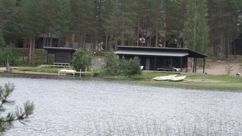
Yxningens Camping, Yxningens Camping, Gusum, Schweden
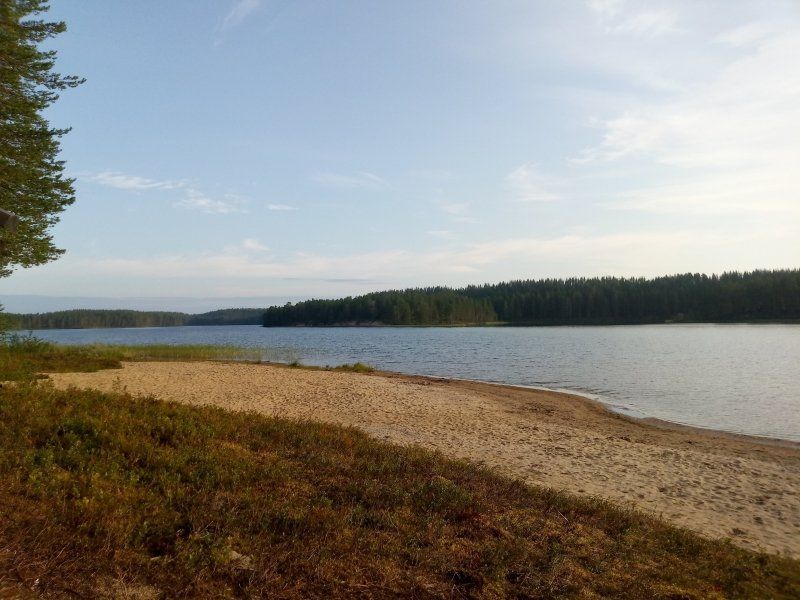
The camping site in Sweden is at a lake again. The lake is also used as a bathing lake for the surrounding villages during the day. When we arrived around 4 p.m. the parking lot was still quite full, but luckily there was already a short-term parking space available for us. At 7 p.m. we took a refreshing swim in the lake. A nice campsite. Again, very nice people from the campsite.
Fishing would also be very possible here. Located in quiet nature. You could stay there one day longer to relax
Yxningens Camping, 610 40 Gusum, Schweden
58° 16' 54.4" N 16° 27' 41.9" E
58.2817860 16.4616360
• Head east on Yxningens camping. Go for 140 m.
• Turn right. Go for 55 m.
• Turn left toward Bråta Nybygget. Go for 594 m.
• Continue on Bråta Nybygget. Go for 1.7 km.
• Continue on Eriksberg Bygget. Go for 1.7 km.
• Turn right onto Bråta Handel. Go for 131 m.
• Continue on Bråta. Go for 261 m.
• Continue on Bråta Alfredsborg. Go for 369 m.
• Turn left onto E22 toward Söderköping. Go for 27.5 km.
• Continue on Tingstad skola (E22). Go for 7.4 km.
• Take the 2nd exit from Ljurarondellen roundabout onto Söderköpingsvägen (E4.8) toward Centrum. Go for 2.2 km.
• Pass 2 roundabouts and continue on Ståthögavägen (E4.8). Go for 2.4 km.
• Take the 1st exit from Sandbyhovsrondellen roundabout onto Stockholmsvägen (E4.8) toward E4. Go for 220 m.
• Take the 2nd exit from Ingelstarondellen roundabout onto Stockholmsvägen (E4.8) toward E4/51/55/56. Go for 1.6 km.
• Continue on Stockholmsvägen. Go for 315 m.
• Continue toward Trafikplats Norrköping norra. Go for 297 m.
• Continue on Trafikplats Norrköping norra. Go for 406 m.
• Continue on E4 (Trafikplats Norrköping norra). Go for 155 km.
• Keep right onto E20 (Gärdestunneln) toward Norrtull. Go for 1.1 km.
• Take the left exit toward E18/Norrtälje onto Norra Länken. Go for 1.7 km.
• Continue on Roslagsvägen (E18.20). Go for 61.8 km.
• Take exit 192 toward Helsingfors/Helsinki/Kapellskär onto E18. Go for 22.8 km.
• Turn left onto E18. Go for 407 m.
• Turn right onto E18. Go for 175 m.
• Take the Kapellskär-Långnäs-Nådendal Ferry. Stay on for 91.2 km.
• Take the Naantali-Långnäs-Kapellskär Ferry. Stay on for 126 km.
• Head northwest on E18. Go for 624 m.
• Continue on Järveläntie (E18). Go for 295 m.
• Turn right onto Viljatie (E18) toward E63/8/40/Helsinki/Turku. Go for 2.1 km.
• Turn right and take ramp onto Armonlaaksontie (E18) toward Turku/Helsinki. Go for 2.2 km.
• Take ramp toward Helsinki/Raisio/8/E63. Go for 340 m.
• Turn right onto E18 toward Helsinki/8/E63/Raisio. Go for 10.5 km.
• Take ramp onto E63 (Tampereen Valtatie) toward Tampere/Tammerfors/Lentoasema. Go for 122 km.
• Take the left exit toward Tampere/Valkeakoski onto E12/E63. Go for 28.7 km.
• Take exit 39-40 toward Jyväskylä/Lahti/12 onto E63 (Pyhäjärventie). Go for 77.5 km.
• Turn left onto Eväjärventie (343) toward Mänttä/Halli. Go for 9.4 km.
• Turn left onto Kuorevedentie (343). Go for 1.9 km.
• Turn right onto Korpitie. Go for 421 m.
• Turn right onto Lammintie. Go for 170 m.
• Turn left onto Manuntie. Go for 115 m.
• Turn slightly left onto Peltoinlammintie. Go for 684 m.
• Turn left. Go for 395 m.
• Arrive at your destination.
☍
765,2 km
(12 hrs. 1 min.)
Vuorensivuntie 79, 35600 Jämsä, Finnland
61° 52' 18.4" N 24° 49' 42.7" E
61.8717659 24.8285338
• Head toward Peltoinlammintie. Go for 395 m.
• Turn right onto Peltoinlammintie. Go for 684 m.
• Turn slightly right onto Manuntie. Go for 115 m.
• Turn right onto Lammintie. Go for 170 m.
• Turn left onto Korpitie. Go for 421 m.
• Turn left onto Kuorevedentie (343). Go for 1.9 km.
• Turn right onto Kolhintie (343). Go for 9.4 km.
• Turn right onto Tampereentie (E63) toward Tampere/Länkipohja. Go for 40.9 km.
• Continue on Tampereentie (E63). Go for 34.1 km.
• Take exit 40 toward Helsinki/Turku onto E12/E63. Go for 30.6 km.
• Take exit 32 toward Turku/Viiala onto E63. Go for 122 km.
• Take the exit toward Naantali/Nådendal/Raisio/Reso/8/E63 onto E18 (Turun Kehätie). Go for 11.6 km.
• Turn right onto Raisionlahdentie (E18) toward Naantali. Go for 2.0 km.
• Take ramp toward Satama. Go for 309 m.
• Turn left onto Vantontie (E18) toward Satama. Go for 2.5 km.
• Turn left onto Satamatie (E18) toward Långnäs/Kapellskär. Go for 34 m.
• Turn right onto E18. Go for 456 m.
• Turn left onto E18. Go for 176 m.
• Take the Naantali-Långnäs-Kapellskär Ferry. Stay on for 126 km.
• Take the Naantali-Långnäs-Kapellskär Ferry. Stay on for 91.2 km.
• Head toward Kapellskär on E18. Go for 175 m.
• Turn right onto E18. Go for 432 m.
• Take the 3rd exit from roundabout onto E18. Go for 113 m.
• Turn right onto E18. Go for 21.8 km.
• Take ramp onto E18. Go for 62.6 km.
• Keep left onto Norra Länken toward E4/Helsingborg/E20/Lidingö/277. Go for 583 m.
• Take the exit toward E4/Helsingborg onto E20 (Norra Länken). Go for 36.7 km.
• Continue on E4 (Trafikplats Saltskog östra) toward Helsingborg/Nyköping. Go for 120 km.
• Keep right onto Trafikplats Norrköping norra toward Norrköping N C/55/Ingelsta/56. Go for 1.0 km.
• Continue toward 55/56. Go for 215 m.
• Continue on Stockholmsvägen toward 55/56. Go for 662 m.
• Continue on E4.8 (Stockholmsvägen). Go for 1.2 km.
• Take the 2nd exit from Ingelstarondellen roundabout onto Stockholmsvägen (E4.8) toward Centrum. Go for 273 m.
• Take the 3rd exit from Sandbyhovsrondellen roundabout onto Ståthögavägen (E4.8) toward Centrum. Go for 1.1 km.
• Pass 3 roundabouts and continue on Söderköpingsvägen (E22). Go for 6.6 km.
• Keep left onto Söderköpingsvägen (E22) toward Kalmar. Go for 10.6 km.
• Continue on Erik Dahlbergsgatan (E22) toward 210. Go for 21.4 km.
• Turn right toward Bråta. Go for 202 m.
• Continue on Bråta Alfredsborg. Go for 167 m.
• Continue on Bråta. Go for 261 m.
• Continue on Bråta Handel. Go for 131 m.
• Turn left toward Eriksberg Bygget. Go for 1.4 km.
• Continue on Eriksberg Bygget. Go for 297 m.
• Continue on Bråta Nybygget. Go for 2.3 km.
• Turn right toward Yxningens camping. Go for 55 m.
• Turn left onto Yxningens camping. Go for 140 m.
• Arrive at Yxningens camping. Your destination is on the right.
☍
765,0 km
(12 hrs. 5 min.)
Day
4. Tag, Montag, Ettappenlänge ca. 314 km
On this day the main destination is Stockholm, where the ferry to Finland leaves in the evening. It's still very warm. The intention is to let the dogs run around before boarding the ferry and visiting the old market hall in Stockholm.
We are therefore looking for a parking space with electricity for about 4 hours.
Yxningens Camping, Yxningens Camping, Gusum, Schweden
Day 4 starts again with great sunshine and blue skies, 26 °.
Our goal: to see Stockholm and the city. The parking space near the city center is unfortunately completely occupied. Nothing can be done without prior reservation. Not even for 4 hours, because then our ferry would leave. The nice young lady tells us that there is another parking space at an exhibition center. This is a bit away from the center and offers nothing else apart from electricity. But we can run the air conditioning for the dogs, so that we can swing on the bike calmly and head for the next destination by bike.
Yxningens Camping, 610 40 Gusum, Schweden
58° 16' 54.4" N 16° 27' 41.9" E
58.2817860 16.4616360
• Head east on Yxningens camping. Go for 140 m.
• Turn right. Go for 55 m.
• Turn left toward Bråta Nybygget. Go for 594 m.
• Continue on Bråta Nybygget. Go for 1.7 km.
• Continue on Eriksberg Bygget. Go for 1.7 km.
• Turn right onto Bråta Handel. Go for 131 m.
• Continue on Bråta. Go for 261 m.
• Continue on Bråta Alfredsborg. Go for 369 m.
• Turn left onto E22 toward Söderköping. Go for 27.5 km.
• Continue on Tingstad skola (E22). Go for 7.4 km.
• Take the 2nd exit from Ljurarondellen roundabout onto Söderköpingsvägen (E4.8) toward Centrum. Go for 2.2 km.
• Pass 2 roundabouts and continue on Ståthögavägen (E4.8). Go for 2.4 km.
• Take the 1st exit from Sandbyhovsrondellen roundabout onto Stockholmsvägen (E4.8) toward E4. Go for 220 m.
• Take the 2nd exit from Ingelstarondellen roundabout onto Stockholmsvägen (E4.8) toward E4/51/55/56. Go for 1.6 km.
• Continue on Stockholmsvägen. Go for 315 m.
• Continue toward Trafikplats Norrköping norra. Go for 297 m.
• Continue on Trafikplats Norrköping norra. Go for 406 m.
• Continue on E4 (Trafikplats Norrköping norra). Go for 146 km.
• Take exit 154 toward Södermalm/Liljeholmen onto Södertäljevägen. Go for 3.1 km.
• Continue on Liljeholmsbron. Go for 358 m.
• Turn right onto Hornsgatan toward Skanstull/Medborgarplatsen/Södersjukhuset. Go for 2.3 km.
• Continue on Slussbron. Go for 209 m.
• Continue on Skeppsbron. Go for 754 m.
• Turn right onto Strömbron. Go for 178 m.
• Turn right onto Södra Blasieholmshamnen. Go for 71 m.
• Turn left onto Stallgatan. Go for 212 m.
• Continue on Nybrokajen. Go for 38 m.
• Continue on Nybrohamnen. Go for 136 m.
• Turn left onto Nybroplan. Go for 24 m.
• Continue on Sibyllegatan. Go for 349 m.
• Turn left onto Östermalmstorg. Go for 44 m.
• Arrive at Östermalmstorg. Your destination is on the right.
☍
201,2 km
(2 hrs. 15 min.)
Östermalms Saluhall, Stockholm, Schweden
We were already in the old market hall in 2015 and that's why I wanted to go there again. When we finally arrived by bike, it was closed for renovation. The new hall looked cool and not as beautiful as the old one. Somehow the flair was missing.
The outward tour by bike turned out to be a bit complicated, as there were some construction sites on the bike paths. Google Maps had a hard time with it and so we did one or two laps :-)
The cycle path network is great in Stockholm, so we found the way back much faster. But in between we treated ourselves to a delicious lunch in the city.
Östermalm, 114 42 Stockholm, Schweden
59° 20' 9.5" N 18° 4' 44.2" E
59.3359666 18.0789358
• Head toward Sibyllegatan on Östermalmstorg. Go for 44 m.
• Turn left onto Sibyllegatan. Go for 189 m.
• Turn left onto Linnégatan. Go for 373 m.
• Turn right onto Sturegatan. Go for 615 m.
• Continue on Lidingövägen. Go for 1.4 km.
• Continue on Lidingövägen. Go for 7 m.
• Keep right onto Lidingövägen toward 277/Lidingö/Värtahamnen. Go for 263 m.
• Take the 1st exit from roundabout onto Södra hamnvägen. Go for 167 m.
• Turn left onto Södra hamnvägen toward Riga/Tallinn/E20/Värtahamnen. Go for 115 m.
• Turn right onto Södra hamnvägen. Go for 34 m.
• Turn left toward Södra hamnvägen. Go for 40 m.
• Turn slightly left onto Södra hamnvägen. Go for 4 m.
• Arrive at Södra hamnvägen. Your destination is on the right.
☍
3,3 km
( 7 min.)
Värtahamnen, Stockholm, Schweden
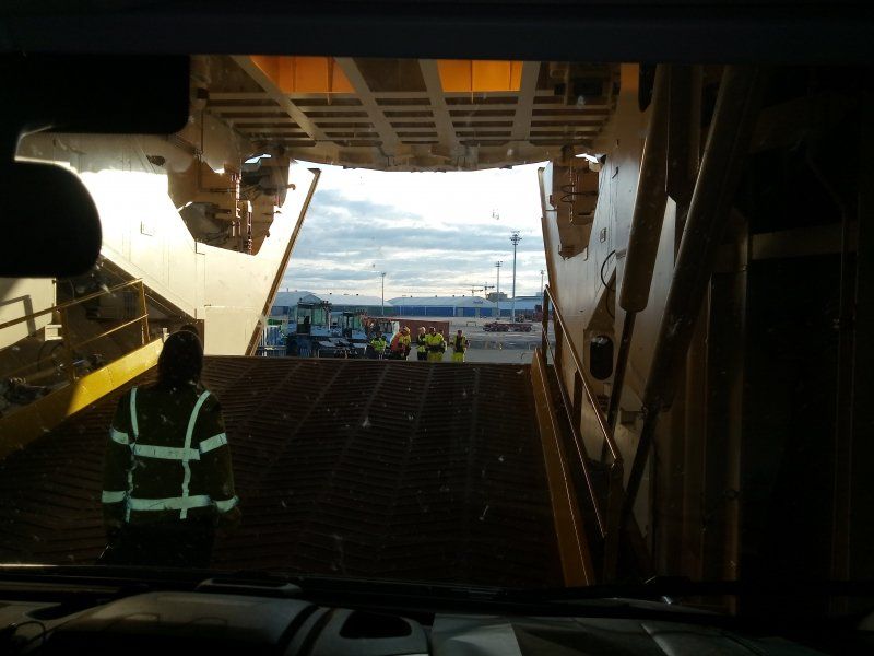
Here we went on the ferry to Turku.
Our cabin was not yet "dry", but since we have a not very easy dog of the two, we asked if we could move into the room. No problem at all and so we went to our cute little room for the night.
The ferry already offered a lot of delicious food, shop, casino so that the evening passed quickly. Neither of our dogs wanted to use the pee tree for the dogs. But everything was calm and relaxed.
115 41 Stockholm, Schweden
59° 21' 0.2" N 18° 6' 26.2" E
59.3500630 18.1072679
• Head northeast on Södra hamnvägen. Go for 74 m.
• Turn left onto Södra hamnvägen. Go for 115 m.
• Turn right onto Södra hamnvägen. Go for 145 m.
• Take the 2nd exit from roundabout onto Lidingövägen toward E4/E18/E20/Centrum. Go for 320 m.
• Take ramp onto E20 (Norra Länken). Go for 1.7 km.
• Take the exit toward E18/Norrtälje onto Norra Länken. Go for 1.6 km.
• Continue on Roslagsvägen (E18.20). Go for 61.8 km.
• Take exit 192 toward Helsingfors/Helsinki/Kapellskär onto E18. Go for 22.8 km.
• Turn left onto E18. Go for 407 m.
• Turn right onto E18. Go for 175 m.
• Take the Kapellskär-Långnäs-Nådendal Ferry. Stay on for 91.2 km.
• Take the Naantali-Långnäs-Kapellskär Ferry. Stay on for 126 km.
• Head northwest on E18. Go for 624 m.
• Continue on Järveläntie (E18). Go for 295 m.
• Turn right onto Viljatie (E18) toward E63/8/40/Helsinki/Turku. Go for 2.1 km.
• Turn right and take ramp onto Armonlaaksontie (E18) toward Turku/Helsinki. Go for 10.6 km.
• Turn left onto Köydenpunojankatu. Go for 949 m.
• Continue on Köydenpunojankaari. Go for 433 m.
• Turn left and take ramp. Go for 113 m.
• Turn right onto Yrjänänkatu. Go for 8 m.
• Turn right onto Satakunnantie. Go for 923 m.
• Turn right onto Eerikinkatu. Go for 173 m.
• Turn right onto Brahenkatu. Go for 157 m.
• Turn left onto Yliopistonkatu. Go for 138 m.
• Arrive at Yliopistonkatu.
☍
322,5 km
(7 hrs. 18 min.)
Day
5. Tag, Dienstag Ankunft in Finnland, Ettapenlänge ca. 1014 km
Made it, Finland reached the first destination of the trip. The crossing was calm and after a short morning coffee we were allowed to leave the ferry with our LMC and the two dogs.
We had picked out a few cities where something should be seen. Unfortunately the first day in Finland started at 12 ° * brrrrr * and clouds. The temperature dropped to 9 ° over the course of the day. But ideal, because we wanted to see something in the cities too.
The first town we went to (name follows) should have a great market. With vegetable and fruit stands, handicrafts, etc. We had found the market and a great parking lot. Unfortunately the market turned out to be very small 3 vegetable stands, 1 fish stand and that was it. Then to the next town, there should also be an old market hall. Easy parking and found the covered market and they turned out to be great. Many small stalls with typical Finnish products. We bought Finnish cheese and enjoyed a coffee with delicious Finnish cakes
Turku, Finnland
60° 27' 6.5" N 22° 15' 59.9" E
60.4518126 22.2666302
• Head toward Brahenkatu on Yliopistonkatu. Go for 302 m.
• Turn left onto Aninkaistenkatu. Go for 663 m.
• Keep right toward Tampere/Tammerfors/Lentoasema/Flygplats/9/E63. Go for 53 m.
• Continue on 9. Go for 443 m.
• Keep left onto Tampereentie (9) toward Tampere/Tammerfors/Lentoasema/E63. Go for 126 km.
• Take the left exit toward Tampere/Valkeakoski onto E12/E63. Go for 28.7 km.
• Continue on 3495 toward Tampere. Go for 5.1 km.
• Keep left toward Keskusta/Centrum. Go for 112 m.
• Continue on Tampereen Valtatie toward Keskusta/Centrum. Go for 635 m.
• Take the 2nd exit from roundabout onto Tampereen Valtatie toward Ratina/3/11/12. Go for 922 m.
• Continue on Hämeenpuisto. Go for 545 m.
• Turn right onto Hallituskatu. Go for 450 m.
• Arrive at Hallituskatu.
☍
163,6 km
(1 hrs. 55 min.)
Tampere, Finnland
61° 29' 51.9" N 23° 45' 39.4" E
61.4977524 23.7609535
• Head east on Hallituskatu.
• Turn right onto Kirkkokatu. Go for 140 m.
• Continue on Laukontori. Go for 101 m.
• Continue on Satamakatu. Go for 346 m.
• Turn left onto Hämeenpuisto. Go for 446 m.
• Turn slightly left onto Tampereen Valtatie. Go for 941 m.
• Take the 2nd exit from roundabout onto Tampereen Valtatie toward Sairaala/Jyväskylä/9/12/Lahti/Lentoasema/Helsinki/Turku. Go for 482 m.
• Turn right onto Lempääläntie (3495) toward Lentoasema/Helsinki/3/Turku/9/Nekala. Go for 2.4 km.
• Take exit 40 toward Jyväskylä/Lahti/12 onto E63 (Pyhäjärventie). Go for 43.7 km.
• Take ramp toward Keuruu/Mänttä/66/Virrat. Go for 291 m.
• Take the 3rd exit from roundabout onto Orivedentie (58) toward Virrat/Keuruu/Mänttä. Go for 245 m.
• Take the 2nd exit from roundabout onto Mäntäntie (58) toward Keuruu/Mänttä/Virrat. Go for 67.8 km.
• Turn right onto Kalettomantie (6045) toward Kaleton. Go for 4.3 km.
• Turn right onto Jyväskyläntie (23) toward Jyväskylä. Go for 20.9 km.
• Turn left onto Siltatie. Go for 432 m.
• Turn slightly right onto Vanhankirkontie. Go for 308 m.
• Arrive at Vanhankirkontie. Your destination is on the left.
☍
142,9 km
(1 hrs. 45 min.)
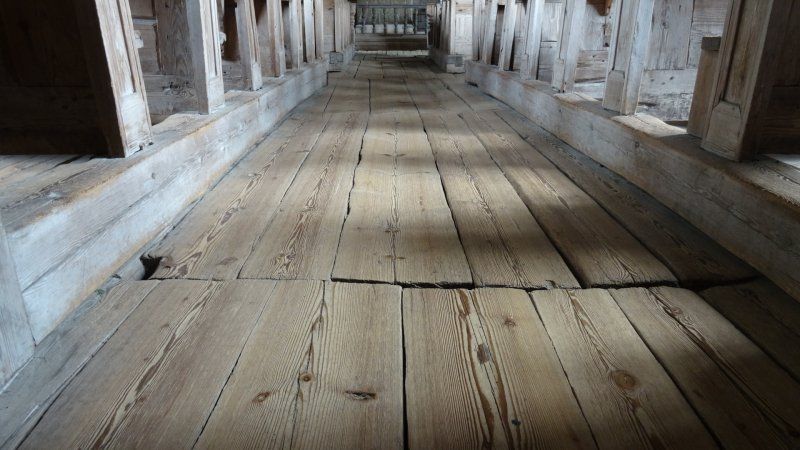
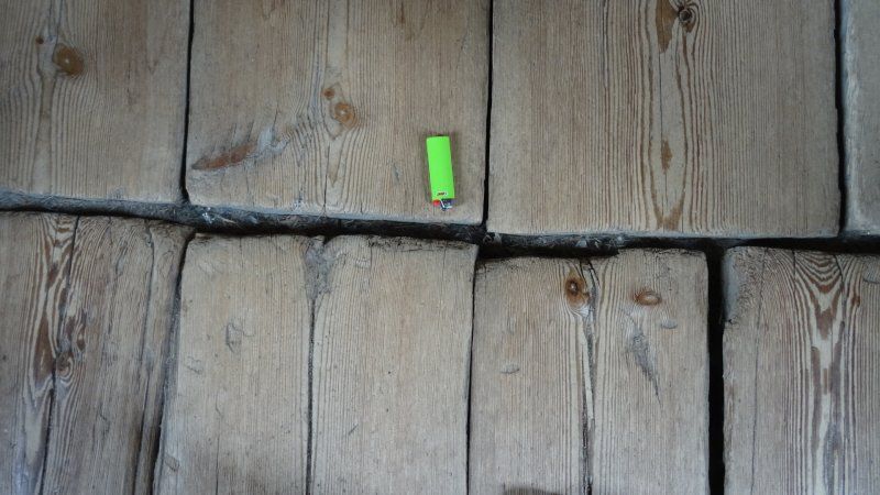
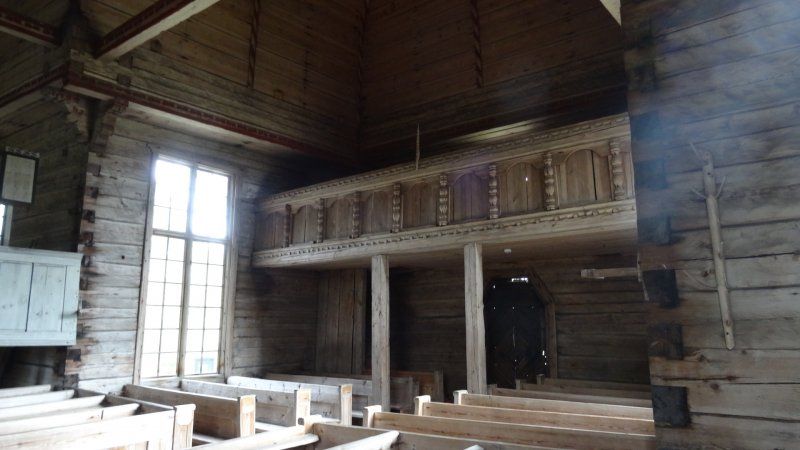
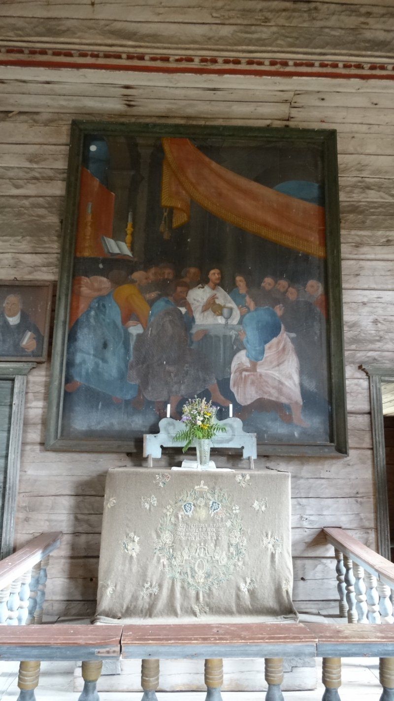
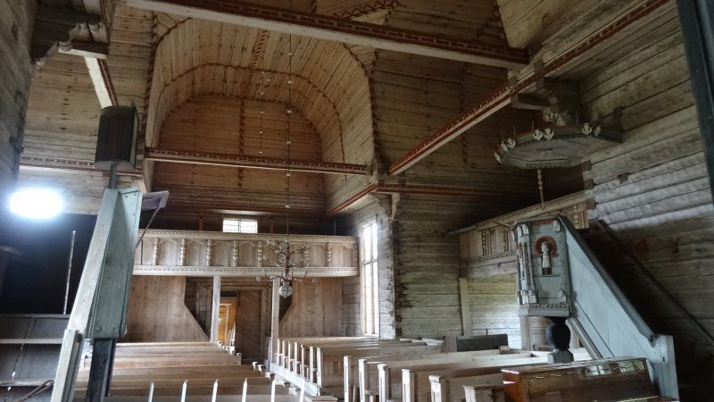
Petäjävesi Old Church, Petäjävesi, Finnland
In the travel guide we discovered the old stave church. We decided to take a look at them, as we unfortunately had not found many other options that interested us.
There is a small parking lot by the river near the church, which is also suitable for mobile homes. You can walk to the church in 5 minutes.
The church was built in 1763/1764. For me it is always associated with awe when you look at the achievements of people back then. The young lady at the reception told us that the church has so far been spared a fire. Our comment: What a sacred place. If you are interested in old handicrafts and churches, this is the place for you.
41900 Petäjävesi, Finnland
62° 15' 0.5" N 25° 11' 2.1" E
62.2501498 25.1839150
• Head northwest on Vanhankirkontie. Go for 308 m.
• Turn slightly left onto Siltatie. Go for 432 m.
• Turn left onto Petäjävedentie (23). Go for 896 m.
• Take the 2nd exit from roundabout onto Petäjävedentie (23) toward Jyväskylä. Go for 16.1 km.
• Turn right onto Metsärannantie. Go for 554 m.
• Arrive at Metsärannantie. Your destination is on the right.
☍
18,3 km
( 16 min.)
Jyväskylä METSÄRANTA, Metsärannantie, Jyväskylä, Finnland
The campsite was in the middle of the forest by a lake. Actually an idyllic location. But the operators or employees weren't exactly the friendliest. The weather was still cool and cloudy. After we got to know Finland on the first day, I was disappointed. Except for the staff church and the market hall, it was somehow not what I had thought. Drive, drive, forest, road, forest, road. Then there was the lack of sun, the campground which was not ideal for me and thus the "forest blues" was born ;-) The route on this day was probably a bit too long for me. But who has ever had a forest blues ;-)
There were two sanitary rooms, too few for the number of people staying overnight. Because in each room there was 1 toilet, 1 washbasin and 1 shower together, with the toilet in the middle of the room. Everything did not make the latest impression and not optimally maintained.
Metsärannantie 56, 41930 Kuohu, Finnland
62° 15' 41.8" N 25° 28' 5.6" E
62.2616120 25.4682331
• Head south on Metsärannantie.
• Arrive at Metsärannantie. Your destination is on the right.
☍
Distance not available
(Duration not available)
Day
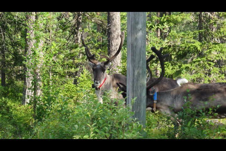
Tag 6, Mittwoch Rentiere, Ettappenlänge ca. 482 km
On the 6th day we had to have breakfast in the mobile home for the first time. It was too cold. We drove off without sadness leaving this place. Continue on the endless streets.
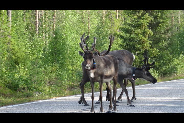
Soon the first signs appeared, reindeer herding area. Well, if they put up as many warning reindeer signs as warning moose and that equates with sighting them, that would mean = 0
But things turned out differently, and soon we saw the first reindeer. You have to be very careful because they think they have right of way. They are such noble wonderful animals and at the same time the sun came out again and the temperatures rose.
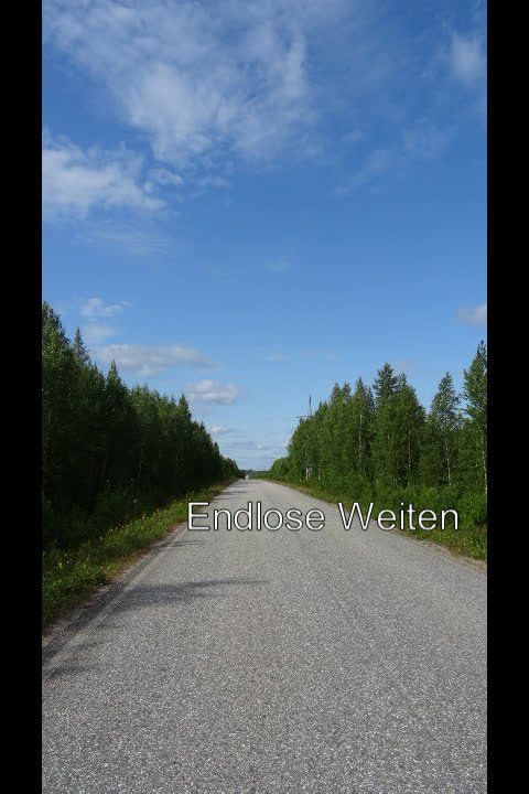
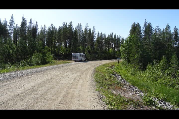
If you leave the main road to find a quiet place for lunch, it is almost always gravel roads. The turning is worthwhile, because then you will also find abandoned spots. But you also understand where the troll stories come from. Because with so much loneliness and forest, at some point you will see a troll behind every tree.
Refueling shouldn't be pushed back on the way. Petrol stations are getting rahr. Oh yes, diesel came in at 1.61 euros / liter, phew. But after we had already paid 10 euros for 1 small bowl of raspberries and blueberries, we were no longer shocked.
Jyväskylä METSÄRANTA, Metsärannantie, Jyväskylä, Finnland
Metsärannantie 56, 41930 Kuohu, Finnland
62° 15' 41.8" N 25° 28' 5.6" E
62.2616120 25.4682331
• Head north on Metsärannantie. Go for 554 m.
• Turn right onto Keuruuntie (18/23). Go for 6.8 km.
• Turn left onto Ruokkeentie (16685) toward Palokka. Go for 8.5 km.
• Take the 2nd exit from roundabout onto Palokanorsi (16685). Go for 167 m.
• Continue toward Palokanorsi/16685. Go for 27 m.
• Take the 2nd exit from roundabout onto Palokanorsi (16685). Go for 246 m.
• Take the 1st exit from roundabout onto E75 (Nelostie) toward Oulu/Kokkola. Go for 175 km.
• Continue on Ouluntie (E75) toward Oulu. Go for 32.6 km.
• Pass 3 roundabouts and continue on Ouluntie (E75). Go for 23.3 km.
• Turn right onto Leskeläntie (800) toward Piippola. Go for 8.1 km.
• Turn left onto Keskustie (800). Go for 19.4 km.
• Turn right onto Kestiläntie (800). Go for 26.7 km.
• Turn left onto Neittäväntie (8794). Go for 10.8 km.
• Turn right onto Neittäväntie (19007). Go for 8.1 km.
• Turn left onto Vuolijoentie (800). Go for 2.3 km.
• Turn right onto Vaalantie (800). Go for 1.3 km.
• Take the 2nd exit from roundabout onto Vaalantie (800). Go for 59.4 km.
• Turn right onto Utajärventie (837). Go for 4.2 km.
• Turn left onto Taivalkoskentie (800) toward Taivalkoski/Joukokylä. Go for 57.2 km.
• Turn right onto Perangantie (8980). Go for 37.4 km.
• Continue on Selkoskyläntie (9190) toward Hossa. Go for 25.1 km.
• Turn left onto Hossantie (843). Go for 3.7 km.
• Turn left onto Hossanniementie. Go for 26 m.
• Continue on Lumontie. Go for 239 m.
• Turn left. Go for 40 m.
• Arrive at your destination on the left.
☍
511,1 km
(6 hrs. 1 min.)
Camping Hossan Lumo
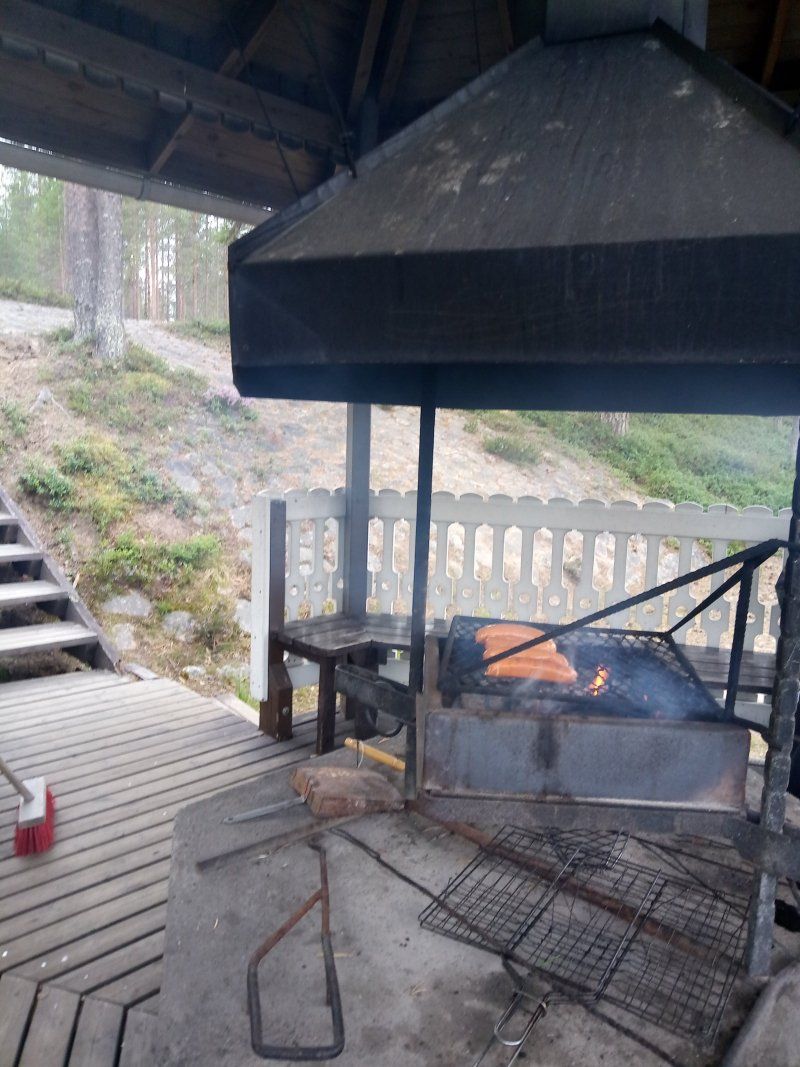
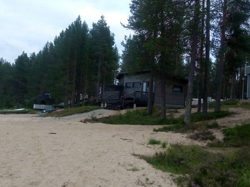
This campsite is beautifully located on a lake in the middle of the forest. Staff super nice and friendly. Small shop where you could even get grilled sausage.
The campsite has a great sauna and barbecue area. We really enjoyed both in the evening. Sitting outside at 11 p.m. and it's still light, just great. I could stay longer at the campsite. Sanitary facilities, kitchens, everything was great!
89920, Ruhtinansalmi, Finnland
65° 26' 31.2" N 29° 33' 3.6" E
65.4420000 29.5510000
• Head south.
• Arrive at your destination on the left.
☍
Distance not available
(Duration not available)
Day
Tag 7, Donnerstag Auf zum Weihnachtsmann Ettappenlänge ca. 437 km
Camping Hossan Lumo
89920, Ruhtinansalmi, Finnland
65° 26' 31.2" N 29° 33' 3.6" E
65.4420000 29.5510000
• Head toward Lumontie. Go for 40 m.
• Turn right onto Lumontie. Go for 239 m.
• Continue on Hossanniementie. Go for 26 m.
• Turn left onto Hossantie (843). Go for 35.4 km.
• Continue on Kerontie (8421). Go for 12.3 km.
• Turn right onto Kajaanintie (E63). Go for 29.8 km.
• Take the 2nd exit from roundabout onto Kemijärventie (E63) toward Lentoasema/Kemijärvi/Rovaniemi/Ruka. Go for 98.3 km.
• Arrive at Kuusamontie (E63). Your destination is on the right.
☍
176,0 km
(1 hrs. 57 min.)
Kahvila- Ja Ruokapaikka Luokkala Oy, Kuusamontie, Suomutunturi, Finnland
Here is a coffee, bistro just before you cross the Arctic Circle. This place is less known than Rovaniemi. But it also has its charm. So we reached the Arctic Circle twice
Kuusamontie 1623, 98720 Suomutunturi, Finnland
66° 33' 16.6" N 28° 5' 16.7" E
66.5546205 28.0879641
• Head toward Raakuntie on Kuusamontie (E63). Go for 42.1 km.
• Turn left onto Kirkkokatu toward Keskusta. Go for 207 m.
• Turn left onto Vapaudenkatu. Go for 433 m.
• Enter the roundabout. Go for 57 m.
• Arrive at your destination on the left.
☍
42,8 km
( 28 min.)
Kemijärvi, Finnland
98100 Kemijärvi, Finnland
66° 42' 49.1" N 27° 25' 45.1" E
66.7136282 27.4292063
• Follow the roundabout. Go for 44 m.
• Take the 3rd exit from roundabout onto Luusuantie. Go for 350 m.
• Turn left onto Rovaniementie (E63). Go for 3.0 km.
• Continue on Rovaniementie (82) toward Rovaniemi. Go for 57.2 km.
• Turn left onto Sodankyläntie (E75) toward Rovaniemi. Go for 25.5 km.
• Take ramp toward Muonio/Pello/Kajaani/78/83/Keskusta/Centre/Ounasvaara. Go for 334 m.
• Turn left onto Kantatie 79 (79) toward Kajaani/Ranua/Keskusta/Ounasvaara/78. Go for 373 m.
• Turn left toward Kajaani/Ranua/Ounasvaara. Go for 12 m.
• Arrive at Toripuistikko (78). Your destination is on the left.
☍
86,9 km
( 59 min.)
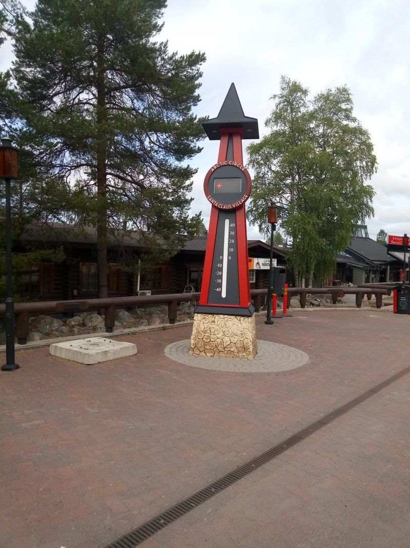
Rovaniemi, Finnland
Reached the Arctic Circle and visited Santa Claus Village.
When there is snow, you certainly cannot see the gray asphalt and the atmosphere is definitely better. But still it was a change to come.
Photos taken from the Arctic Circle, better from the marking. Postcards for Christmas sent to Santa's post office. We are curious to see whether they will arrive in time for Christmas.
There are of course many shops where you can always find the same thing for sale. But a couple of stores were very interesting. Like the shop where you could buy a wide variety of knives.
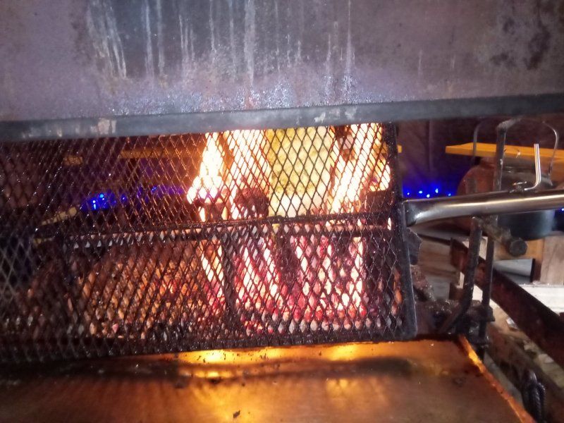
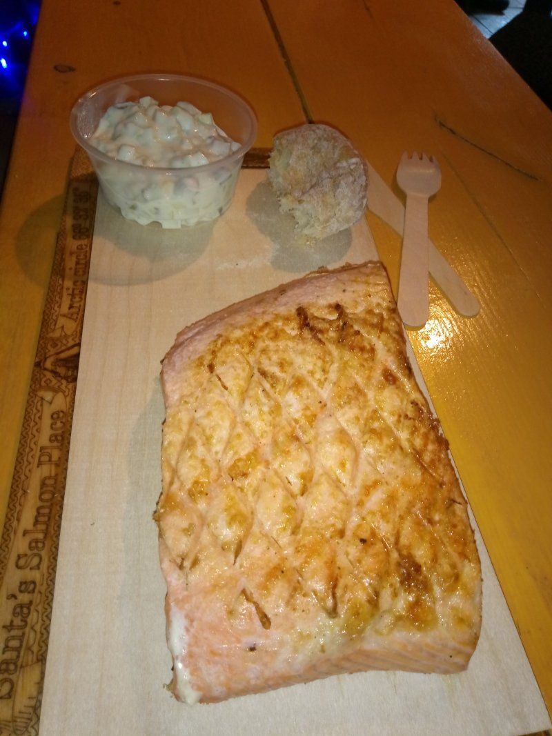
For dinner we treated ourselves to a flambé salmon with potato salad. We share a portion for 20 euros. That was completely sufficient as a snack for in between.
66° 30' 14.2" N 25° 43' 45.8" E
66.5039478 25.7293906
• Head southeast on Toripuistikko (78). Go for 257 m.
• Make a U-Turn onto Toripuistikko (78). Go for 324 m.
• Turn right onto Poromiehentie (79) toward Ivalo/4/Kemi/Muonio/83/E75/Lentoasema. Go for 231 m.
• Keep left onto Kantatie 79 (79) toward Muonio/Kittilä/Kemi/4/Pello/83/E75. Go for 93 m.
• Keep left toward Kemi. Go for 43 m.
• Take ramp onto Valtatie 4 (E75) toward Kemi. Go for 106 km.
• Turn left and take ramp onto E8 toward Tornio/21/E4. Go for 14.4 km.
• Take the 3rd exit from roundabout onto Kromitie (922) toward Röyttä/Outokumpu. Go for 825 m.
• Turn left onto Koskenrannantie. Go for 79 m.
• Turn right onto Matkailijantie. Go for 514 m.
• Arrive at Matkailijantie. Your destination is on the right.
☍
122,8 km
(1 hrs. 23 min.)
Camping Tornio, Matkailijantie, Tornio, Finnland
Matkailijantie, 95470 Tornio, Finnland
65° 49' 54.2" N 24° 12' 7.1" E
65.8317310 24.2019710
• Head east on Matkailijantie.
• Arrive at Matkailijantie. Your destination is on the right.
☍
Distance not available
(Duration not available)
Day
Tag 8, Freitag, Ettappenlänge ca. 548 km
The nature remains the same as in Finland. We are still in the "Lapland" area. Unfortunately we didn't see any more reindeer here. Do I still see a moose after all?
Camping Tornio, Matkailijantie, Tornio, Finnland
Matkailijantie, 95470 Tornio, Finnland
65° 49' 54.2" N 24° 12' 7.1" E
65.8317310 24.2019710
• Head toward Proomuranta on Matkailijantie. Go for 514 m.
• Turn left onto Koskenrannantie. Go for 79 m.
• Turn right onto Kromitie (922). Go for 663 m.
• Take the 3rd exit from roundabout onto E8 toward Tornio/21/E4. Go for 2.6 km.
• Take the 2nd exit from roundabout onto Valtatie (E4) toward Ruotsi/Haaparanta. Go for 266 m.
• Continue on E4. Go for 284 m.
• Pass 4 roundabouts and continue on E4. Go for 50.8 km.
• Take the 2nd exit from roundabout onto E4 toward Sundsvall. Go for 402 m.
• Take the 2nd exit from roundabout onto E4 toward Sundsvall. Go for 596 m.
• Take the 1st exit from roundabout onto E4 toward Sundsvall. Go for 67.0 km.
• Take ramp toward Gammelstads Kyrkstad/Rutvik/Porsön. Go for 340 m.
• Turn left onto Rutviksvägen. Go for 4.1 km.
• Turn sharp left onto Gamla hamngatan. Go for 37 m.
• Arrive at Gamla hamngatan. Your destination is on the left.
☍
127,6 km
(1 hrs. 29 min.)
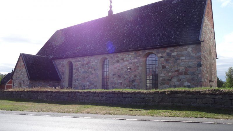
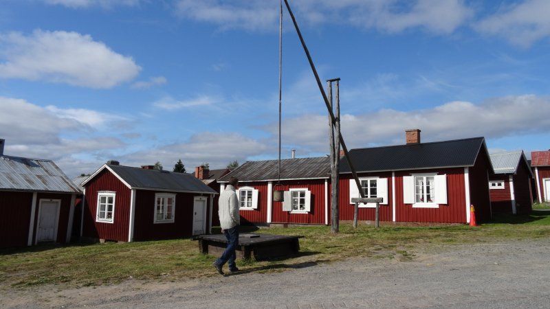
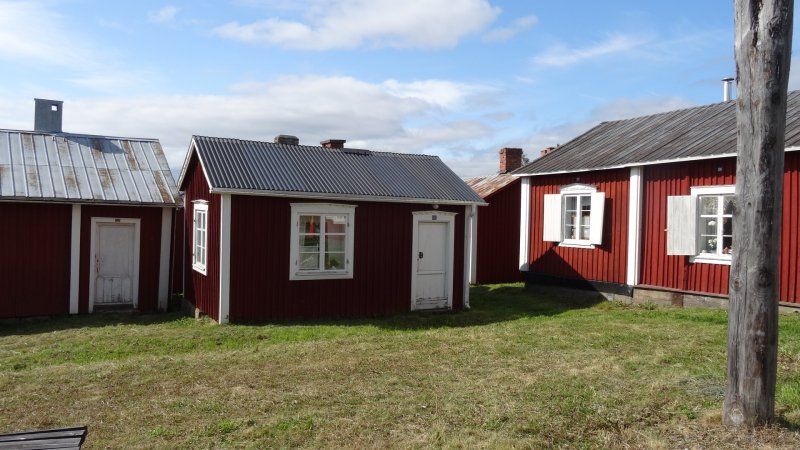
Gammelstad Church Town, Kyrktorget, Gammelstad, Schweden
A visit to the church town and the church is worthwhile.
Information can be found here, for example: https: //colorfulcities.de/2018 ...
Kyrktorget 1, 954 33 Gammelstad, Schweden
65° 38' 46.8" N 22° 1' 42.9" E
65.6463420 22.0285910
• Head northeast on Gamla hamngatan. Go for 11 m.
• Turn right onto Kyrktorget. Go for 63 m.
• Turn right toward Kyrktorget. Go for 6 m.
• Turn left onto Kyrktorget. Go for 1.8 km.
• Take the 2nd exit from roundabout onto Lulevägen. Go for 205 m.
• Turn left and take ramp onto 97 toward Luleå. Go for 1.3 km.
• Take ramp onto E4 toward Sundsvall/Karlsvik/Flygplats. Go for 13.9 km.
• Take ramp toward Arvidsjaur/Älvsbyn/Antnäs. Go for 273 m.
• Continue on 94 toward Arvidsjaur/Älvsbyn/Antnäs. Go for 42.0 km.
• Pass 2 roundabouts and continue on Nyvägen. Go for 2.6 km.
• Take the 2nd exit from roundabout onto Storgatan. Go for 626 m.
• Turn left onto Stationsgatan. Go for 188 m.
• Arrive at Stationsgatan. Your destination is on the left.
☍
63,0 km
( 45 min.)
Älvsbyn, Schweden
65° 40' 37.7" N 20° 59' 34.3" E
65.6771363 20.9928658
• Head toward Råggatan on Stationsgatan. Go for 462 m.
• Continue on Västermalmsvägen. Go for 1.6 km.
• Turn right onto Dalbäcken (94). Go for 4.5 km.
• Turn left onto Korsträsk toward Koler/Storsund. Go for 2.7 km.
• Continue on Petbergsliden. Go for 7.4 km.
• Continue on Arvidsträsk. Go for 7.2 km.
• Continue on Teugerträsk. Go for 4.2 km.
• Continue on Storsundsvägen. Go for 4.0 km.
• Turn right toward Stambanevägen. Go for 10.0 km.
• Continue on Stambanevägen. Go for 2.8 km.
• Turn right onto Stor-Blålidenvägen. Go for 9.7 km.
• Continue on Björkliden. Go for 2.9 km.
• Continue on Stor-Blålidenvägen. Go for 3.1 km.
• Turn right onto 373. Go for 31.7 km.
• Turn left onto Siksjön. Go for 12.7 km.
• Continue on Moräng. Go for 4.2 km.
• Continue on Skjutbanevägen. Go for 686 m.
• Continue on Storgatan. Go for 38 m.
• Turn right onto Storgatan (95). Go for 520 m.
• Turn left onto Brännberg (365) toward Lycksele/Norsjö. Go for 110 km.
• Take the 2nd exit from roundabout onto Blå vägen (E12). Go for 311 m.
• Take the 1st exit from roundabout onto Blå vägen (E12). Go for 307 m.
• Turn left onto Vilhelminavägen (365). Go for 79.6 km.
• Turn right onto 92 toward Dorotea/Åsele. Go for 7.8 km.
• Take the 2nd exit from roundabout onto Umevägen (92) toward Dorotea/Centrum. Go for 20.7 km.
• Continue on Lomsjö (92). Go for 26.2 km.
• Turn left onto E45 toward Östersund/Dorotea. Go for 4.5 km.
• Turn left onto Storgatan. Go for 194 m.
• Turn right onto Storgatan. Go for 76 m.
• Arrive at Storgatan. Your destination is on the left.
☍
359,7 km
(3 hrs. 54 min.)
Doro Camp Lapland, Storgatan, Dorotea, Schweden
Storgatan 1A, 917 31 Dorotea, Schweden
64° 15' 27.8" N 16° 23' 23.1" E
64.2577150 16.3897530
• Head northwest on Storgatan.
• Arrive at Storgatan. Your destination is on the left.
☍
Distance not available
(Duration not available)
Day
Tag 9, Samstag Ettappenlänge ca. 693 km
Doro Camp Lapland, Storgatan, Dorotea, Schweden
Storgatan 1A, 917 31 Dorotea, Schweden
64° 15' 27.8" N 16° 23' 23.1" E
64.2577150 16.3897530
• Head northwest on Storgatan.
• Turn slightly right toward Storgatan/E45. Go for 112 m.
• Turn left onto Storgatan (E45). Go for 563 m.
• Turn left onto E45 toward Östersund. Go for 70.1 km.
• Pass 2 roundabouts and continue on Brogatan (E45). Go for 96.3 km.
• Turn left and take ramp onto E14/E45 toward Sundsvall/Mora/Odenskog. Go for 18.3 km.
• Take the 1st exit from roundabout onto E45 toward Mora/Svenstavik/Viken. Go for 128 km.
• Turn left onto 296 toward Ljusdal/Kårböle. Go for 22.6 km.
• Turn left onto Härjedalsvägen (84/296). Go for 3.0 km.
• Turn right onto Losvägen (296) toward Voxna/Los. Go for 33.8 km.
• Turn right onto Kyrkbyn Hamravägen (310). Go for 24.6 km.
• Turn left onto E45. Go for 63.1 km.
• Pass 6 roundabouts and continue on Vasagatan (E45). Go for 14.6 km.
• Take the 3rd exit from Cirkulationsplats Stranden roundabout onto Strandgatan (E45) toward Centrum. Go for 537 m.
• Take the 2nd exit from Cirkulationsplats Kaplanen roundabout onto Strandgatan (E45) toward Flygplats. Go for 509 m.
• Take the 2nd exit from roundabout onto Malungsvägen (E45) toward Flygplats. Go for 1.3 km.
• Take the 2nd exit from roundabout onto Malungsvägen (E45). Go for 34.8 km.
• Turn right onto Johannisholm (E45) toward Karlstad/Malung. Go for 32.2 km.
• Take the 2nd exit from roundabout onto Moravägen (E16/E45) toward Oslo/Torsby/Karlstad/Sjukhus/Centrum. Go for 44.9 km.
• Turn left onto Värnäsmon (62) toward Karlstad/Hagfors/Stöllet. Go for 73.6 km.
• Take the 2nd exit from roundabout onto 62 toward Karlstad/Sunne. Go for 8.8 km.
• Turn left onto Erlandervägen. Go for 1.7 km.
• Turn left onto Erlandervägen. Go for 435 m.
• Arrive at Erlandervägen. Your destination is on the right.
☍
674,4 km
(8 hrs. 26 min.)
Storängens Camping, Stugor & Outdoor, Erlandervägen, Ransäter, Schweden
Erlandervägen 2, 684 93 Ransäter, Schweden
59° 45' 48.1" N 13° 26' 55.4" E
59.7633567 13.4487224
• Head southeast on Erlandervägen.
• Arrive at Erlandervägen. Your destination is on the right.
☍
Distance not available
(Duration not available)
Day
Storängens Camping, Stugor & Outdoor, Erlandervägen, Ransäter, Schweden
Erlandervägen 2, 684 93 Ransäter, Schweden
59° 45' 48.1" N 13° 26' 55.4" E
59.7633567 13.4487224
• Head northwest on Erlandervägen. Go for 435 m.
• Turn left onto Erlandervägen. Go for 561 m.
• Turn right onto 62. Go for 107 m.
• Turn left toward Karlstad. Go for 204 m.
• Continue toward Karlstad. Go for 357 m.
• Turn right onto 62 toward Karlstad. Go for 41.3 km.
• Take the 2nd exit from roundabout onto 61/62 toward Karlstad. Go for 5.2 km.
• Take ramp toward Oslo/E18/Göteborg/E45. Go for 626 m.
• Continue on Eriksberg. Go for 681 m.
• Turn left and take ramp onto Eriksberg (E18) toward Oslo/Göteborg/E45. Go for 15.8 km.
• Take the 2nd exit from Wounded Knee roundabout onto E18/E45 toward Göteborg/Oslo. Go for 15.0 km.
• Take the exit toward Göteborg/Säffle onto E45. Go for 36.2 km.
• Pass 3 roundabouts and continue on Landsvägsgatan (E45). Go for 90.2 km.
• Take ramp onto E45 toward Flygplats/Göteborg/Mariestad/Trollhättan. Go for 2.3 km.
• Take ramp onto E45 toward Mariestad/Göteborg/Trollhättan/42/47/Flygplats. Go for 4.5 km.
• Take ramp onto Edsborgsvägen (E45) toward Göteborg/Trollhättan C. Go for 992 m.
• Pass 6 roundabouts and continue on E45. Go for 68.2 km.
• Keep right onto E45 toward Göteborg. Go for 5.5 km.
• Take ramp onto E6 toward Holmen/E45/E20/Malmö/40/Flygplats/Jönköping. Go for 671 m.
• Keep left toward Kungsbackaleden/E6. Go for 33 m.
• Continue on E6 (Kungsbackaleden). Go for 94 m.
• Keep left onto E6 (Olskroksmotet). Go for 150 m.
• Continue on E20 (Olskroksmotet). Go for 213 km.
• Take exit 28 toward Helsingborg S onto E4 (Trafikplats Helsingborg S). Go for 5.6 km.
• Take the 2nd exit from roundabout onto Malmöleden (E4) toward Centrum. Go for 558 m.
• Turn right onto Oljehamnsleden (E4) toward Industriområde Gåsebäck. Go for 532 m.
• Turn right onto Sjögatan (E4) toward Helsingör Scandlines. Go for 719 m.
• Take the 1st exit from roundabout onto Bredgatan toward Scandlines. Go for 711 m.
• Take the Helsingborg-Helsingör Ferry. Stay on for 5.0 km.
• Head west on Færgevej. Go for 726 m.
• Take the 1st exit from roundabout onto Færgevej toward Helsingør C. Go for 758 m.
• Continue on Stationspladsen. Go for 76 m.
• Turn right onto Jernbanevej (O1). Go for 106 m.
• Continue on Havnegade (O1). Go for 301 m.
• Continue on Allegade (O1). Go for 251 m.
• Continue on Allegade (237). Go for 281 m.
• Continue on Sanct Anna Gade (237). Go for 613 m.
• Turn right onto Nordre Strandvej. Go for 29 m.
• Turn right onto Strandalleen. Go for 72 m.
• Turn slightly right onto Campingvej. Go for 127 m.
• Arrive at Campingvej. Your destination is on the left.
☍
519,1 km
(6 hrs. 35 min.)
Helsingør Camping, Strandalleen, Helsingør, Dänemark
Strandalleen 2, 3000 Helsingør, Dänemark
56° 2' 35.8" N 12° 36' 17.9" E
56.0432735 12.6049809
• Head east on Campingvej.
• Arrive at Campingvej. Your destination is on the left.
☍
Distance not available
(Duration not available)
Day
Helsingør Camping, Strandalleen, Helsingør, Dänemark
Strandalleen 2, 3000 Helsingør, Dänemark
56° 2' 35.8" N 12° 36' 17.9" E
56.0432735 12.6049809
• Head west on Campingvej. Go for 127 m.
• Turn slightly left onto Strandalleen. Go for 72 m.
• Turn left onto Nordre Strandvej. Go for 29 m.
• Turn left onto Lappen (237). Go for 613 m.
• Continue on Allegade (237). Go for 281 m.
• Turn right onto Kronborgvej (O1). Go for 188 m.
• Continue on I. L. Tvedes Vej (O1). Go for 409 m.
• Continue on Trækbanen (O1). Go for 366 m.
• Turn right onto Kongevejen. Go for 2.2 km.
• Pass 2 roundabouts and continue on Kongevejen (E47). Go for 2.4 km.
• Keep left onto Helsingørmotorvejen (E47) toward E55s/E47s/København. Go for 47.3 km.
• Take the exit toward Odense/Rødby/Gedser onto E20/E47 (Køge Bugt Motorvejen). Go for 26.4 km.
• Keep right onto E47/E55 (Køge Vest) toward Rødby/Gedser. Go for 77.6 km.
• Continue on E47 (Sydmotorvejen) toward Rødby. Go for 44.4 km.
• Take the Rødby-Puttgarden Ferry. Stay on for 18.7 km.
• Head southwest on E47. Go for 865 m.
• Continue on B207. Go for 21.3 km.
• Continue on A1. Go for 128 km.
• Take the left exit toward Bremen/Hannover/HH-Stillhorn onto A1. Go for 15.2 km.
• Take the exit toward Bremen/Seevetal-Hittfeld onto A1 (Horster Dreieck). Go for 104 km.
• Take exit 58A toward Oldenburg onto A28. Go for 33.7 km.
• Take exit 16 toward Wilhelmshaven onto A29. Go for 47.9 km.
• Take exit 6 toward Sande/Flughafen Mariensiel/Friedeburg. Go for 316 m.
• Turn left onto B436 toward Leer/Friedeburg/Neustadtgödens. Go for 2.3 km.
• Turn right onto Marienburg (K96) toward Jever/Dykhausen/Gödens. Go for 344 m.
• Continue on K96. Go for 490 m.
• Continue on Gödens (K96). Go for 1.1 km.
• Continue on Gödenser Straße (K96). Go for 1.7 km.
• Continue on Dykhauser Straße (K96). Go for 1.8 km.
• Continue on Eilksstraße (K96). Go for 561 m.
• Turn right onto Kirchstraße (K95). Go for 197 m.
• Turn left onto Menkestraße toward Heidmühle. Go for 1.1 km.
• Turn left onto Elsa-Brändström-Straße. Go for 233 m.
• Arrive at Elsa-Brändström-Straße. Your destination is on the right.
☍
582,8 km
(6 hrs. 22 min.)
Schortens, Deutschland
26419 Schortens, Deutschland
53° 32' 17.2" N 7° 56' 39.3" E
53.5381133 7.9442591