A leisurely tour before Easter to places that are certainly overcrowded during the main travel season.
Day
Bivange, Luxemburg
Bivingen, Luxemburg
49° 32' 40.8" N 6° 8' 8.6" E
49.5446533 6.1357148
• Head toward Rue des Jardins on Rue de Kockelscheuer. Go for 115 m.
• Turn right onto Rue Edward Steichen (CR159). Go for 2.0 km.
• Turn right onto N31. Go for 691 m.
• Take left ramp onto A3 toward France/Esch sur Alzette. Go for 6.7 km.
• Continue on A31. Go for 35.3 km.
• Take the exit toward Metz-Est/Sarrebruck/Strasbourg onto A4 (Autoroute de l'Est). Go for 167 km.
• Continue on A35. Go for 2.3 km.
• Take exit 4 toward Montagne Verte/Lingolsheim. Go for 952 m.
• Turn right onto Rue de la Montagne Verte toward Strasbourg-Centre/Montagne Verte/Lingolsheim/Ostwald. Go for 265 m.
• Continue on Pont de la Montagne Verte. Go for 99 m.
• Continue on Rue de la Tour Verte. Go for 259 m.
• Turn left onto Route de Schirmeck (M392) toward Lingolsheim/Ostwald/Montagne Verte. Go for 277 m.
• Turn right onto Rue de l'Auberge de Jeunesse. Go for 141 m.
• Continue on Rue de l'Auberge de Jeunesse. Go for 55 m.
• Turn left onto Rue de l'Auberge de Jeunesse. Go for 12 m.
• Turn right. Go for 52 m.
• Arrive at your destination on the right.
☍
216,7 km
(2 hrs. 5 min.)
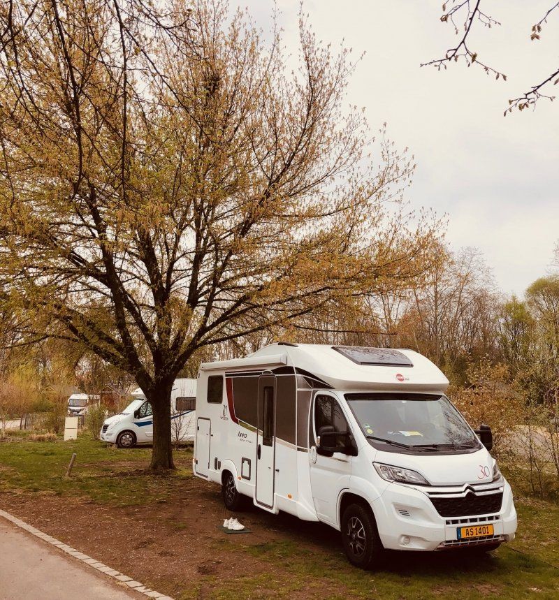
Camping de Strasbourg
Netter Campingplatz in Laufnähe zur gemütlichen Stadt Strassburg.
Rue de l'Auberge de Jeunesse, 67200, Strasbourg, Frankreich
48° 34' 31.1" N 7° 43' 1.9" E
48.5753000 7.7172000
• Head northwest. Go for 45 m.
• Turn right toward Rue de l'Auberge de Jeunesse. Go for 268 m.
• Turn left onto Rue de l'Auberge de Jeunesse. Go for 196 m.
• Turn left onto Route de Schirmeck (M392). Go for 259 m.
• Turn right onto Rue de la Tour Verte toward A35/Colmar/Kehl/Elsau/Meinau. Go for 261 m.
• Continue on Rue de la Montagne Verte. Go for 99 m.
• Continue on Rue de la Montagne Verte. Go for 265 m.
• Turn left and take ramp onto A35 toward Mulhouse/Colmar/Illkirch-Graff. Go for 14.1 km.
• Take the exit toward Mulhouse/Colmar/Obernai onto A35. Go for 40.7 km.
• Continue on D83. Go for 10.7 km.
• Keep left onto A35. Go for 22.9 km.
• Take the exit toward Meyenheim. Go for 471 m.
• Turn slightly left onto D201. Go for 1.5 km.
• Take the 3rd exit from roundabout onto D201 toward Réguisheim/Ensisheim. Go for 1.5 km.
• Take the 1st exit from roundabout onto Rue d'Ensisheim (D201). Go for 150 m.
• Turn right onto Rue du Pont (D47). Go for 171 m.
• Continue on D47. Go for 134 m.
• Continue on Rue des Tilleuls (D47). Go for 446 m.
• Continue on D47. Go for 627 m.
• Turn left onto D44. Go for 3.0 km.
• Continue on Rue de Reguisheim (D44). Go for 268 m.
• Take the 2nd exit from roundabout onto Rue de Reguisheim (D44). Go for 260 m.
• Continue on Place de la Mairie (D44). Go for 64 m.
• Turn left onto Place de la Mairie (D4 BIS). Go for 81 m.
• Turn right onto Rue de Feldkirch (D44). Go for 868 m.
• Continue on D44. Go for 904 m.
• Turn left and take ramp onto D430 toward Mulhouse/Pulversheim. Go for 2.6 km.
• Take ramp onto Route de Mulhouse (D429) toward Pulversheim/Écomusée/Petit Prince. Go for 415 m.
• Take the 3rd exit from roundabout onto D49. Go for 253 m.
• Take the 1st exit from roundabout. Go for 374 m.
• Keep right. Go for 61 m.
• Turn right. Go for 202 m.
• Turn sharp right. Go for 117 m.
• Arrive at your destination on the right.
☍
104,1 km
(1 hrs. 8 min.)
Day
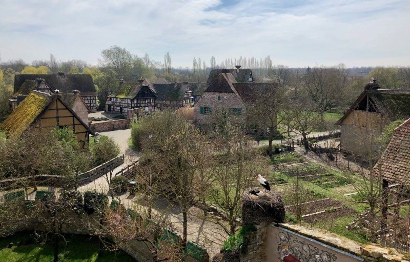
Écomusée d’Alsace, Chemin du Grosswald, Ungersheim, Frankreich
On the way to Basel, we stopped at the Ecomusée d'Alsace. Many historic farmhouses and craftsmen's houses in the area have been rebuilt here. Storks also seem to feel at home here.
Chemin du Grosswald, 68190 Ungersheim, Frankreich
47° 51' 9.3" N 7° 17' 14" E
47.8525950 7.2872160
• Head west. Go for 131 m.
• Turn left. Go for 94 m.
• Turn right. Go for 66 m.
• Turn slightly right toward D49. Go for 339 m.
• Take the 2nd exit from roundabout onto D49. Go for 247 m.
• Take the 1st exit from roundabout onto Route de Mulhouse (D429) toward Guebwiller/Mulhouse/Bollwiller/Feldkirch/Ungersheim/Cité Alex. Go for 263 m.
• Take left ramp onto D430 toward A36-A35/Mulhouse. Go for 10.7 km.
• Take ramp onto A36 (La Comtoise) toward Strasbourg/Freiburg/Basel/Euroairport. Go for 4.9 km.
• Take the exit toward Basel/Aéroport Euroairport onto Échangeur de Bâle-Mulhouse. Go for 1.5 km.
• Continue on A35. Go for 25.3 km.
• Continue on A3. Go for 7.5 km.
• Take exit 6 toward Delémont/Muttenz onto A18 (Verzweigung Hagnau). Go for 4.3 km.
• Take the exit toward Reinach-Nord onto Sundgauerstrasse. Go for 829 m.
• Turn left onto Baselstrasse (18). Go for 641 m.
• Turn left onto Krummenrainweg. Go for 48 m.
• Turn right onto Dornacherweg. Go for 88 m.
• Turn left onto Heideweg. Go for 246 m.
• Turn right onto Heideweg. Go for 473 m.
• Arrive at Heideweg. Your destination is on the right.
☍
57,7 km
( 44 min.)
Camping Waldhort, Heideweg, Reinach, Schweiz
The campsite is located just outside of Basel, but can be easily reached by tram every 15 minutes (free tickets are available at reception).
Heideweg 16, 4153 Reinach, Schweiz
47° 29' 58.7" N 7° 36' 10.3" E
47.4996383 7.6028737
• Head toward In der Heid on Heideweg. Go for 473 m.
• Turn left onto Heideweg. Go for 246 m.
• Turn right onto Dornacherweg. Go for 88 m.
• Turn left onto Krummenrainweg. Go for 48 m.
• Turn right onto Baselstrasse (18). Go for 1.3 km.
• Take the 3rd exit from roundabout onto Reinacherstrasse (18). Go for 1.2 km.
• Pass 2 roundabouts and continue on Reinacherstrasse (18). Go for 1.8 km.
• Turn left onto Münchensteinerstrasse (18). Go for 459 m.
• Keep left toward Münchensteinerstrasse/18. Go for 45 m.
• Turn left onto Nauenstrasse (2). Go for 551 m.
• Keep left toward Nauentunnel. Go for 132 m.
• Continue on Nauentunnel. Go for 288 m.
• Continue on Steinentorberg. Go for 10 m.
• Continue on Heuwaage-Viadukt. Go for 364 m.
• Continue on Steinengraben. Go for 330 m.
• Continue on Holbeinplatz. Go for 93 m.
• Continue on Schützengraben. Go for 388 m.
• Continue on Schönbeinstrasse. Go for 152 m.
• Turn left onto Mittlere Strasse. Go for 78 m.
• Continue on Klingelbergstrasse. Go for 233 m.
• Continue on Schanzenstrasse. Go for 193 m.
• Turn right onto Spitalstrasse. Go for 251 m.
• Continue on Totentanz. Go for 104 m.
• Turn slightly right onto Blumenrain. Go for 197 m.
• Turn slightly left onto Schifflände. Go for 84 m.
• Arrive at Schifflände.
☍
9,1 km
( 18 min.)
Day
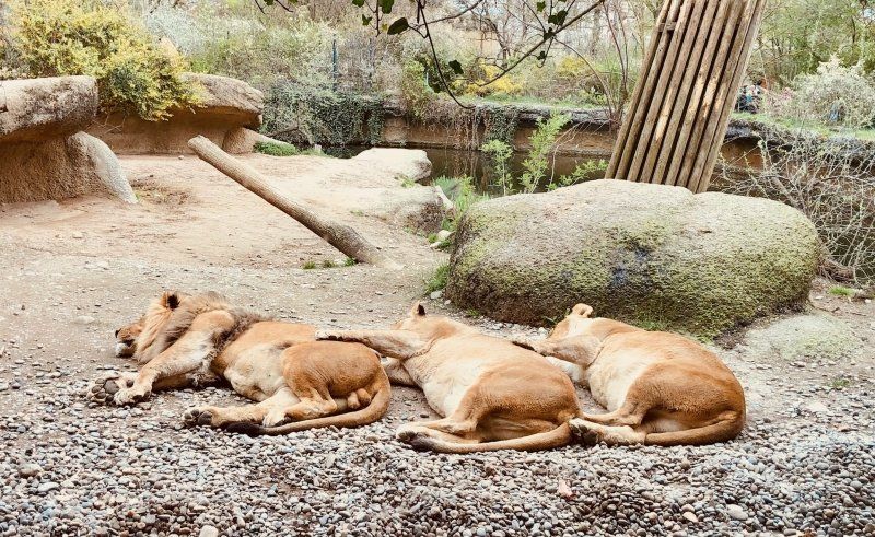
Basel, Schweiz
Basel is just a beautiful city, especially when the weather is nice. A stroll through the city, museums or a visit to the zoo, many things are possible.
47° 33' 34.6" N 7° 35' 18.9" E
47.5595986 7.5885761
• Head northwest on Schifflände. Go for 84 m.
• Turn slightly right onto Blumenrain. Go for 197 m.
• Turn slightly left onto Totentanz. Go for 104 m.
• Continue on Spitalstrasse. Go for 251 m.
• Turn left onto Schanzenstrasse. Go for 193 m.
• Continue on Klingelbergstrasse. Go for 237 m.
• Continue on Mittlere Strasse. Go for 78 m.
• Continue on Schönbeinstrasse. Go for 152 m.
• Continue on Schützengraben. Go for 388 m.
• Continue on Holbeinplatz. Go for 93 m.
• Continue on Steinengraben. Go for 330 m.
• Continue on Heuwaage-Viadukt. Go for 364 m.
• Continue on Steinentorberg. Go for 10 m.
• Keep left toward Nauentunnel. Go for 41 m.
• Continue on Nauentunnel. Go for 379 m.
• Continue on Nauenstrasse (2). Go for 955 m.
• Keep right onto Sankt Jakobs-Strasse. Go for 139 m.
• Keep left onto Basel-Süd/City toward Deutschland/France/Basel-Nord Hafen/EuroAirport/Luzern/Bern/Zürich/Delémont. Go for 380 m.
• Take ramp onto A2/A3 toward Luzern/Bern/Zürich/Delémont/Basel-St. Jakob/Birsfelden Hafen/Muttenz. Go for 9.6 km.
• Keep right onto A2 (Verzweigung Augst) toward Chiasso/Gotthard/Luzern/Bern/Arisdorf. Go for 28.2 km.
• Take the left exit toward Chiasso/Gotthard/Luzern/Zürich/Rothrist onto A1/A2. Go for 8.9 km.
• Take exit 47 toward Chiasso/Gotthard/Luzern/Reiden onto A2 (Verzweigung Wiggertal). Go for 207 km.
• Take exit 49 toward Ponte Tresa/Aeroporto. Go for 2.3 km.
• Turn left onto Via Cantonale (398). Go for 1.4 km.
• Keep right onto Strada Regina (398). Go for 620 m.
• Take the 2nd exit from roundabout onto Strada Regina (398). Go for 2.1 km.
• Turn left onto Piazza Colonnello Vicari (399). Go for 541 m.
• Take the 1st exit from roundabout onto Via Lugano (399). Go for 69 m.
• Turn right onto Via Molinazzo. Go for 259 m.
• Continue straight ahead. Go for 79 m.
• Make a U-Turn. Go for 79 m.
• Turn right. Go for 43 m.
• Turn left. Go for 32 m.
• Turn right. Go for 26 m.
• Arrive at your destination on the right.
☍
265,9 km
(2 hrs. 58 min.)
Day
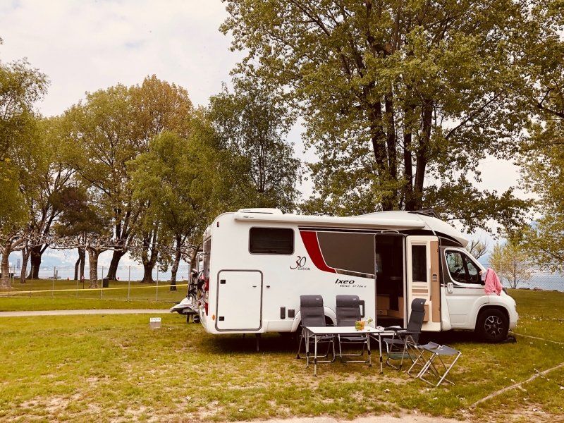
Camping Lugano Lake
Wir haben leider nur eine Nacht, erste Reihe mit Seeblick, hier verbracht, bei dem Wetter ein Traum.
Via Molinazzo 9, 6982, Agno, Schweiz
45° 59' 44.9" N 8° 54' 24.5" E
45.9958000 8.9068000
• Head east.
• Turn right. Go for 26 m.
• Turn right. Go for 67 m.
• Turn left. Go for 79 m.
• Make a U-Turn. Go for 79 m.
• Continue on Via Molinazzo. Go for 259 m.
• Turn right onto Via Lugano (399). Go for 1.7 km.
• Take the 2nd exit from roundabout onto Via al Laghetto (399). Go for 1.1 km.
• Turn right onto Via Paradiso (399). Go for 1.1 km.
• Turn right onto Via Clemente Maraini (2). Go for 283 m.
• Turn right toward Lugano Sud. Go for 594 m.
• Continue on Lugano Sud toward Milano/Chiasso. Go for 202 m.
• Keep left onto Lugano Sud toward Milano/Chiasso. Go for 342 m.
• Take ramp onto A2 toward Milano/Chiasso. Go for 22.7 km.
• Continue on A9 (Autostrada dei Laghi). Go for 31.0 km.
• Take the left exit onto A8 (Autostrada dei Laghi). Go for 5.1 km.
• Take the exit toward E64/Torino/A4/Genova/A7/Bologna/A1 onto A50 (Tangenziale Ovest). Go for 20.5 km.
• Take the exit toward Genova onto A7 (Autostrada Milano-Genova). Go for 125 km.
• Keep left onto A12 (Autostrada Azzurra) toward Genova Est/Livorno. Go for 69.7 km.
• Take the exit toward Levanto. Go for 1.6 km.
• Turn left onto Via Levanto (SP566dir) toward Levanto/Monterosso/SS370/Bonassola/Cinque Terre. Go for 9.9 km.
• Take the 2nd exit from roundabout onto Via Nostra Signora della Guardia (SP566dir) toward Centro. Go for 564 m.
• Take the 3rd exit from roundabout onto SP566dir toward Ridarolo/Legnaro/Chiesanuova/Fontona. Go for 627 m.
• Take the 2nd exit from roundabout onto Corso Roma (SP566dir). Go for 432 m.
• Continue on Corso Roma. Go for 55 m.
• Turn left onto Passeggiata A Mare. Go for 59 m.
• Turn left onto Passeggiata A Mare. Go for 254 m.
• Continue on Piazza Cristoforo Colombo. Go for 131 m.
• Continue on Piazza del Popolo. Go for 88 m.
• Continue on Piazza Giovacchino da Passano. Go for 22 m.
• Turn right onto Via San Nicolò. Go for 67 m.
• Turn right onto Via Sant'Antonio. Go for 35 m.
• Turn left. Go for 15 m.
• Turn left. Go for 93 m.
• Arrive at your destination on the left.
☍
293,7 km
(3 hrs. 14 min.)
Day
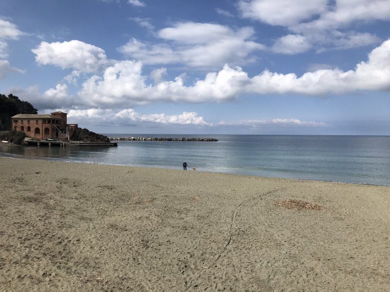
Camping Acquadolce
Gemütlicher Campingplatz in Levanto, sehr nah am Strand sowie auch dem Zentrum mit seinen kleinen Geschäften. Vom Bahnhof aus (15 Minuten zu Fuss) kann man bequem alle Cinque Terre Orte mit dem Zug erreichen.
Der Campingplatz ist immer gut besucht und oft ausgebucht. Am Platz ist ein hervoragendes Restaurant mit guten Pizzen und lokalen Spezialitäten.
Via Guido Semenza 5, 19015, Levanto, Italien
44° 9' 59.4" N 9° 36' 51.8" E
44.1665000 9.6144000
• Head west. Go for 93 m.
• Turn right toward Via Sant'Antonio. Go for 15 m.
• Turn right onto Via Sant'Antonio. Go for 35 m.
• Turn left onto Via San Nicolò. Go for 67 m.
• Turn left onto Piazza Giovacchino da Passano. Go for 22 m.
• Continue on Piazza del Popolo. Go for 72 m.
• Continue on Piazza del Popolo. Go for 16 m.
• Continue on Piazza Cristoforo Colombo. Go for 131 m.
• Continue on Passeggiata A Mare. Go for 296 m.
• Turn right onto Corso Roma. Go for 481 m.
• Pass 3 roundabouts and continue on Località San Gottardo (SP566dir). Go for 11.1 km.
• Take ramp onto A12 (Autostrada Azzurra) toward Parma/A15/Livorno/E31. Go for 26.3 km.
• Take the exit toward Parma onto A15 (Autostrada della Cisa). Go for 100 km.
• Take the exit toward Bologna/Parma onto A1 (Autostrada del Sole). Go for 86.9 km.
• Keep right onto A14 (Autostrada Adriatica) toward Ancona/Ravenna/Padova/A13/Tangenziale/Bologna Borgo Panigale/Bologna Centro/Aeroporto Bologna/Fiera Bologna. Go for 14.8 km.
• Take the exit toward Padova/Bologna Arcoveggio onto A13 (Autostrada Bologna-Padova). Go for 117 km.
• Take the exit toward Venezia onto A4 (Autostrada della Serenissima). Go for 10.0 km.
• Take the exit toward Venezia/Aeroporto onto A57. Go for 19.1 km.
• Take the exit toward Aeroporto onto Raccordo Marco Polo. Go for 6.5 km.
• Keep left onto Raccordo Marco Polo toward Jesolo/SS14/Trieste/Aeroporto. Go for 93 m.
• Take the 2nd exit from roundabout onto Via Triestina (SS14) toward Trieste/Jesolo. Go for 9.1 km.
• Take ramp onto Strada Regionale del Mare (SP43) toward Jesolo/SP42/Eraclea. Go for 9.4 km.
• Pass 4 roundabouts and continue on Via Adriatico. Go for 11.6 km.
• Keep left toward Punta/Sabbioni/Cavallino/SP42/Treporti. Go for 152 m.
• Continue on Via John Lennon. Go for 611 m.
• Continue on Strada Provinciale Jesolana (SP42). Go for 1.3 km.
• Pass 3 roundabouts and continue on Strada Provinciale Jesolana (SP42). Go for 4.2 km.
• Turn left onto Via Danubio. Go for 126 m.
• Turn right onto Via dell'Artigliere. Go for 502 m.
• Turn left onto Via del Granatiere. Go for 22 m.
• Take the 1st exit from roundabout onto Via Francesco Baracca. Go for 458 m.
• Continue on Via Francesco Baracca. Go for 363 m.
• Pass 3 roundabouts and continue on Via Francesco Baracca. Go for 827 m.
• Take the 2nd exit from roundabout onto Via Fausta (SP42) toward Ca' Savio/Punta Sabbioni/Venezia. Go for 6.4 km.
• Take the 2nd exit from roundabout onto Via Fausta (SP42) toward Punta Sabbioni. Go for 1.3 km.
• Take the 3rd exit from roundabout onto Via Fausta (SP42) toward Punta Sabbioni/Venezia. Go for 2.4 km.
• Take the 2nd exit from roundabout onto Via Fausta (SP42) toward Punta Sabbioni. Go for 286 m.
• Turn slightly left onto Via Fausta. Go for 119 m.
• Take the 1st exit from roundabout onto Lungomare Dante Alighieri. Go for 786 m.
• Turn left. Go for 100 m.
• Arrive at your destination on the left.
☍
443,3 km
(4 hrs. 24 min.)
Day
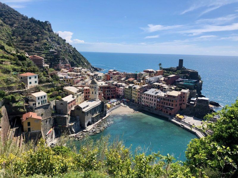
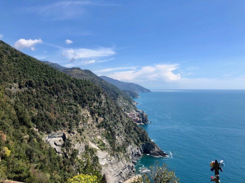
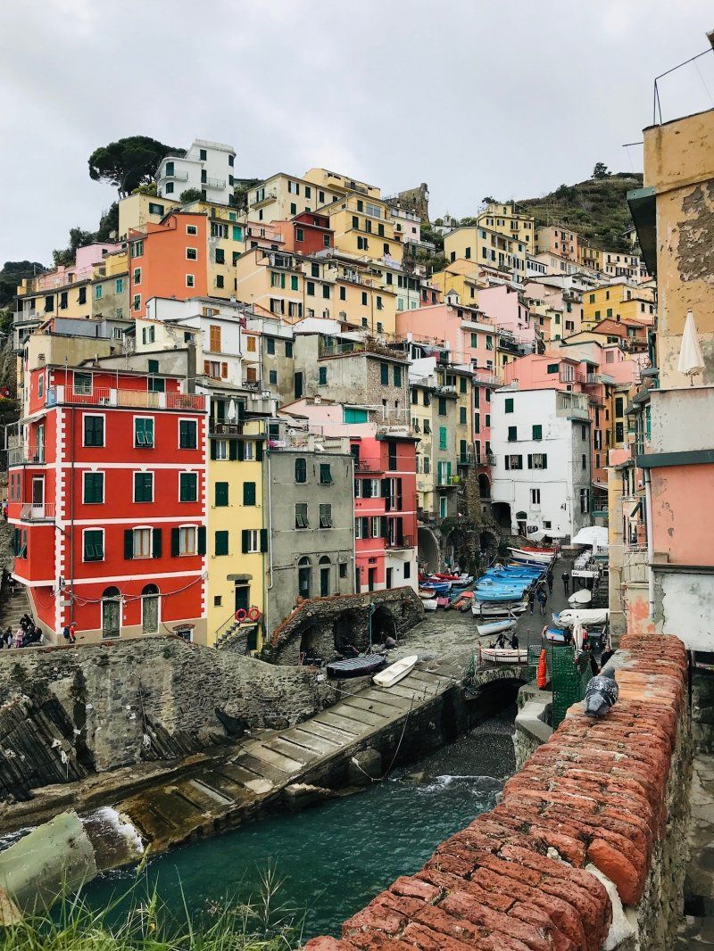
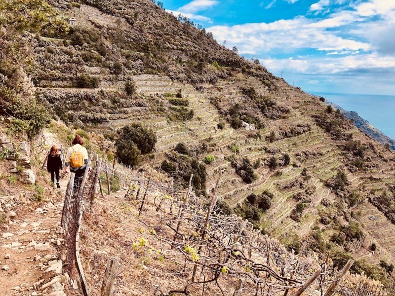
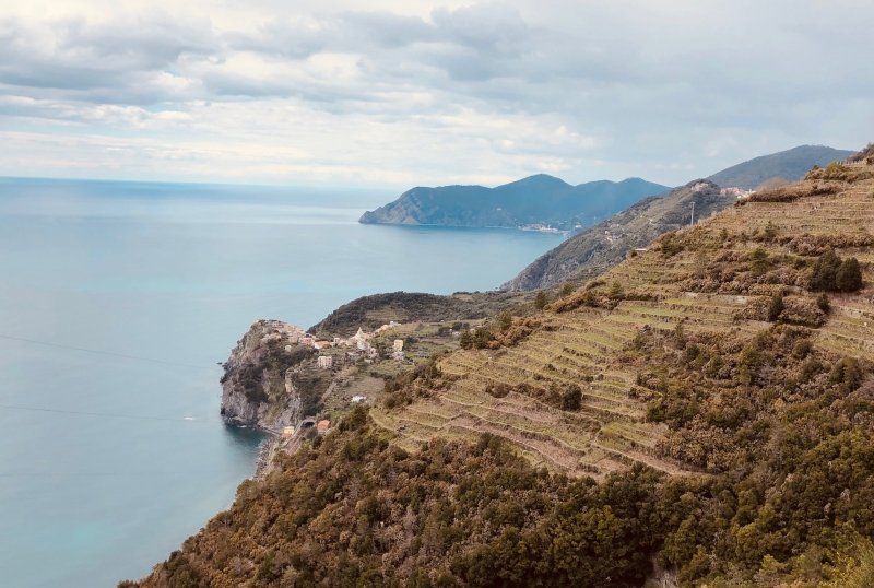
5 Tage in 5 Terre
From Levanto we explored the area by train every day and visited all 5 Terre villages as well as La Spezzia. Especially the hikes from one village to the next were an unforgettable experience, with beautiful views that were more than worth every effort and effort. Good shoes, a bottle of water, some stamina and sure-footedness are required, it is always steep uphill , and back down...
We were happy to visit these wonderful places before Easter and we were not alone...we can't imagine walking through in high season with summer heat and crowds to stroll these beautiful places.
Day
Camping Miramare, Lungomare Dante Alighieri, Cavallino-Treporti, Venedig, Italien
There are two dozen campsites on this peninsula in front of Venice, we chose this smaller site without direct access to the beach, but within walking distance (700m) of the Punta Sabbioni water bus station. The site has very spacious plots and is optimally furnished, especially if you want to explore the city of Venice and not a beach holiday.
Lungomare Dante Alighieri, 29, 30013 Cavallino-Treporti VE, Italien
45° 26' 26.2" N 12° 25' 20.3" E
45.4406055 12.4223072
• Head toward Lungomare Dante Alighieri. Go for 100 m.
• Turn right onto Lungomare Dante Alighieri. Go for 752 m.
• Take the 3rd exit from roundabout onto Via Fausta. Go for 156 m.
• Turn slightly right onto Via Fausta (SP42). Go for 216 m.
• Take the 3rd exit from roundabout onto Via Fausta (SP42) toward Ca' Savio/Jesolo. Go for 2.4 km.
• Pass 2 roundabouts and continue on Via Fausta (SP42). Go for 7.6 km.
• Take the 3rd exit from roundabout onto Via Fausta (SP42) toward Cavallino Centro/Jesolo. Go for 810 m.
• Take the 1st exit from roundabout onto Via Fausta (SP42) toward Autostrada/Venezia/Jesolo. Go for 327 m.
• Take the 1st exit from roundabout onto Via Ca' Martin. Go for 192 m.
• Turn left onto Via Ca' Martin. Go for 39 m.
• Turn right onto Via Fausta (SP42). Go for 916 m.
• Turn right onto Via del Granatiere. Go for 317 m.
• Turn left onto Via dell'Artigliere. Go for 502 m.
• Turn left onto Via Danubio. Go for 126 m.
• Turn right onto Via Fausta (SP42). Go for 1.5 km.
• Pass 3 roundabouts and continue on Via Roma Destra (SP42). Go for 4.0 km.
• Keep left toward Autostrade/Trieste/Udine/Venezia/Treviso. Go for 488 m.
• Continue on Via John Lennon. Go for 275 m.
• Continue on Via Adriatico (SR43). Go for 3.2 km.
• Take the 3rd exit from roundabout onto Via Adriatico toward Venezia/Treviso. Go for 4.6 km.
• Take the 2nd exit from roundabout onto Via Adriatico (SR43) toward Venezia/San Donà di Piave/SS14/A4/Autostrade/A27. Go for 3.2 km.
• Take the 5th exit from roundabout onto Via Armellina (SR43) toward Venezia/A4. Go for 1.2 km.
• Take the 2nd exit from roundabout onto Strada Provinciale Portegrandi-Caposile-Jesolo (SP43) toward Venezia. Go for 8.0 km.
• Turn right onto Via Trezze (SP43) toward Trieste/S. Donà. Go for 615 m.
• Turn left onto Via Trieste (SS14). Go for 318 m.
• Turn left onto Strada Statale della Venezia Giulia (SS14) toward Aeroporto/Venezia/A4. Go for 9.7 km.
• Keep right toward Trieste/A4/Milano/A57/Venezia/Treviso/A27/Belluno. Go for 193 m.
• Continue on Raccordo Marco Polo. Go for 5.0 km.
• Take the exit toward Tangenziale/E70/Milano/A4/Bologna/A13 onto A57. Go for 19.9 km.
• Take the exit onto A4 (Passante di Mestre). Go for 250 km.
• Take the exit toward E62/Varese/Aeroporto Malpensa/Gravellona T./A26/E35/Como-Chiasso/A9 onto A8 (Autostrada Milano-Varese). Go for 10.6 km.
• Take the exit toward Como/Chiasso onto A9 (Autostrada dei Laghi). Go for 32.0 km.
• Continue on A2. Go for 40.3 km.
• Take exit 48 toward Rivera/Monte Ceneri onto 2. Go for 7.7 km.
• Continue on Via Monte Ceneri. Go for 560 m.
• Take the 2nd exit from roundabout onto Via Cantonale (406). Go for 525 m.
• Pass 4 roundabouts and continue on Via Monte Ceneri (406). Go for 3.8 km.
• Keep right onto 406. Go for 1.8 km.
• Take the 2nd exit from roundabout onto A13. Go for 3.4 km.
• Take ramp onto Via San Gottardo (13) toward Orselina/Brione s/M/Muralto/Minusio. Go for 3.7 km.
• Keep left onto Via della Stazione (13). Go for 92 m.
• Turn right onto Via della Stazione (13). Go for 572 m.
• Continue on Lungolago Giuseppe Motta. Go for 466 m.
• Turn left onto Viale al Lido. Go for 280 m.
• Continue on Via Gioacchino Respini. Go for 652 m.
• Turn left onto Viale Giovacchino Respini. Go for 166 m.
• Turn right. Go for 38 m.
• Turn left. Go for 93 m.
• Turn slightly right. Go for 54 m.
• Arrive at your destination on the right.
☍
433,3 km
(4 hrs. 23 min.)
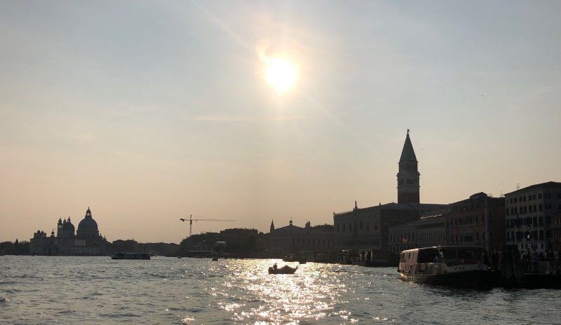
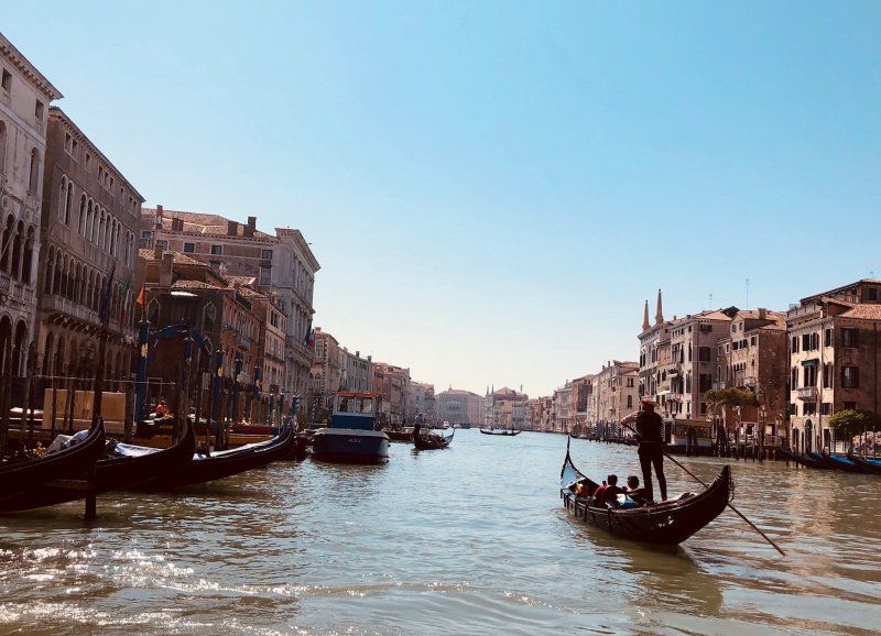
Day
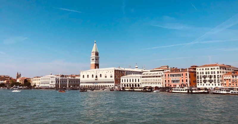
3 Tage Venedig
During 3 days we explored the lagoon city. The water bus from Punta Sabbioni docks directly at San Marco and you are right in the middle of the hustle and bustle, but the quieter squares and alleys are also quickly reached. A small part of Venice is certainly overcrowded, but the city has charm and is beautiful.
Day
Locarno: Camping Delta
Der anscheinend teuerste Platz der Schweiz, und somit wahrscheinlich teuerste Campingplatz der Welt (wenn man den Einträgen in den Internetforen vertrauen kann) ... verglichen mit Plätzen um Venedig ist es schon sehr teuer, 2 Nächte in Locarno kosten mehr als 4 Nächte in Venedig ... ist eben Schweiz, aber ... alles klappt.
Der Platz liegt relativ nahe am Zentrum von Locarno.
Via Respini 27, 6600, Locarno, Schweiz
46° 9' 20.5" N 8° 48' 2.5" E
46.1557000 8.8007000
• Head southeast. Go for 147 m.
• Turn right. Go for 38 m.
• Turn left toward Viale Giovacchino Respini. Go for 6 m.
• Continue on Viale Giovacchino Respini. Go for 160 m.
• Turn right onto Via Gioacchino Respini. Go for 652 m.
• Continue on Viale al Lido. Go for 280 m.
• Continue on Lungolago Giuseppe Motta. Go for 1.7 km.
• Turn right onto Via San Gottardo (13). Go for 2.7 km.
• Take left ramp onto A13 toward Lugano/Bellinzona. Go for 4.0 km.
• Take the 1st exit from roundabout onto 406 toward E35/E43/A2/A13/Lugano/Gambarogno/Aeroporto. Go for 1.4 km.
• Keep left onto Via Monte Ceneri (406). Go for 373 m.
• Pass 5 roundabouts and continue on Via Cantonale (406). Go for 4.3 km.
• Take the 3rd exit from roundabout onto Via San Gottardo (406). Go for 3.6 km.
• Take the 1st exit from roundabout onto In Tirada (2). Go for 213 m.
• Take ramp onto A2 toward San Gottardo/E43/San Bernardino/A13. Go for 189 km.
• Take the exit onto A1/A2. Go for 8.5 km.
• Take exit 45 toward E25/Basel/Egerkingen onto A2. Go for 41.2 km.
• Keep right onto A3 (Basel-Kleinhüningen) toward Mulhouse/EuroAirport/Basel-Kleinhüningen/Lörrach/Weil am Rhein. Go for 3.8 km.
• Continue on A35. Go for 25.5 km.
• Take the exit toward Paris/Lyon/Mulhouse onto A35. Go for 40.5 km.
• Continue on D83. Go for 10.7 km.
• Keep left onto A35. Go for 30.0 km.
• Take exit 11.1 toward Schirmeck/Molsheim/Rosheim/Z.I.-Obernai onto D500. Go for 7.7 km.
• Keep left onto D500 toward Saint-Dié/Molsheim/Schirmeck. Go for 709 m.
• Keep right toward Altorf/Duttlenheim/Saverne/Wasselonne/Zones Industrielles de Molsheim. Go for 110 m.
• Continue on Route d'Altorf (D392). Go for 362 m.
• Take the 3rd exit from roundabout onto D422 toward Saverne/Wasselonne/Zones Industrielles de Molsheim. Go for 1.3 km.
• Continue toward Saverne/Wasselonne/Zone Industrielles de la Hardt. Go for 49 m.
• Take the 2nd exit from roundabout onto D422 toward Saverne/Wasselonne. Go for 954 m.
• Continue toward Saverne/Wasselonne. Go for 42 m.
• Take the 2nd exit from roundabout onto D422 toward Saverne/Wasselonne. Go for 1.5 km.
• Take the 2nd exit from roundabout onto D422 toward Saverne. Go for 1.5 km.
• Take the 1st exit from roundabout onto Rue de Saverne (D422) toward Wasselonne/Avolsheim. Go for 3.3 km.
• Pass 5 roundabouts and continue on D422. Go for 5.3 km.
• Take the 3rd exit from roundabout onto Route du Kronthal toward Metz/Nancy/Saverne/Wasselonne. Go for 2.1 km.
• Pass 4 roundabouts and continue on Rue du Général Leclerc (D1004). Go for 9.3 km.
• Take the 3rd exit from roundabout onto D1004 toward Metz/Nancy/Saverne/Z.I. Marmoutier. Go for 982 m.
• Take the 2nd exit from roundabout onto Rue de Saverne (D1004) toward Metz/Nancy/Saverne. Go for 783 m.
• Take the 3rd exit from roundabout onto Lieu-dit Wachholderbuckel (D1004) toward Strasbourg/Wasselonne/Marmoutier/Metz/Nancy/Saverne/Otterswiller. Go for 953 m.
• Take ramp toward Nancy/Metz/Saverne/Otterswiller. Go for 611 m.
• Take the 1st exit from roundabout onto Route Nationale (D1004) toward Nancy/Metz/Saverne/Gottenhouse/Otterswiller. Go for 908 m.
• Turn left onto Rue du Niederbarr. Go for 546 m.
• Continue on Chemin d'Otterswiller. Go for 264 m.
• Turn slightly right onto Rue du Rossignol. Go for 488 m.
• Continue on Rue Henri Meck. Go for 212 m.
• Arrive at Rue Henri Meck. Your destination is on the right.
☍
408,6 km
(4 hrs. 22 min.)
Day
Seasonova Camping Les Portes d'Alsace
Actually, we wanted to look for a campsite on the Alsatian Wine Route, but all pitches were full without exception, wonderful weather on the Easter weekend ... we got the last pitch in Saverne.
There are a few in Saverne very good restaurants with tasty and hearty meals.
40 rue du pere libermann, 67700, Saverne, Frankreich
48° 43' 55.2" N 7° 21' 20.2" E
48.7320000 7.3556000
• Head northwest on Rue Henri Meck.
• Turn right onto Rue du Père Libermann. Go for 36 m.
• Turn left onto Rue du Maire Knoepffler. Go for 257 m.
• Turn right onto Rue du Général Leclerc (D171). Go for 970 m.
• Turn right onto Route de Paris (D1004). Go for 502 m.
• Turn left onto Rue des Clés (D421). Go for 137 m.
• Turn right onto Rue de Dettwiller (D421) toward A4/Haguenau/Dettwiller/Bouxwiller/Martelberg/Kochersberg. Go for 1.2 km.
• Take the 3rd exit from roundabout onto Rue de Dettwiller (D421). Go for 496 m.
• Take the 3rd exit from roundabout onto Rue de Dettwiller (D421). Go for 268 m.
• Take the 2nd exit from roundabout onto D1404. Go for 2.5 km.
• Take ramp onto A4 (Autoroute de l'Est) toward E25/Phalsbourg/Sarrebruck/Nancy/Metz/Paris. Go for 125 km.
• Take the exit toward Thionville/Luxembourg/Longwy onto A31. Go for 36.2 km.
• Continue on A3. Go for 6.4 km.
• Take exit 2 toward Livange onto N31. Go for 876 m.
• Turn left onto Rue de Bettembourg (CR159). Go for 2.0 km.
• Turn left onto Rue de Kockelscheuer. Go for 115 m.
• Arrive at Rue de Kockelscheuer. Your destination is on the left.
☍
176,7 km
(1 hrs. 40 min.)
Day
Bivange, Luxemburg
Bivingen, Luxemburg
49° 32' 40.8" N 6° 8' 8.6" E
49.5446533 6.1357148