With a caravan and 2 children we went from Berlin via Belgium to France. The destination is the Atlantic. The journey leads via Normandy, Brittany to Lacanau Ocean. In Erquy (Brittany) and Lacanau we move into child-friendly campsites with pool facilities for several days. Well, let's go, let's go on an adventure for the next 3 weeks.
Day
Berlin, Deutschland
52° 31' 12" N 13° 24' 17.8" E
52.5200066 13.4049540
• Head northwest on Karl-Liebknecht-Straße (B2/B5). Go for 15 m.
• Turn left onto Karl-Liebknecht-Straße (B2/B5). Go for 477 m.
• Continue on Schloßbrücke (B2/B5). Go for 78 m.
• Continue on Unter den Linden (B2/B5). Go for 843 m.
• Continue on Unter den Linden (B2). Go for 342 m.
• Turn right onto Wilhelmstraße (B2). Go for 164 m.
• Turn left onto Dorotheenstraße (B2) toward Tiergarten/Reichstag. Go for 240 m.
• Continue on Scheidemannstraße (B2). Go for 539 m.
• Continue on John-Foster-Dulles-Allee. Go for 1.0 km.
• Turn left onto Spreeweg. Go for 367 m.
• Take the 2nd exit from Großer Stern roundabout onto Straße des 17. Juni (B2/B5) toward A100/Charlottenburg. Go for 1.9 km.
• Take the 3rd exit from Ernst-Reuter-Platz roundabout onto Bismarckstraße (B2/B5) toward Magdeburg/A100/Leipzig/ICC. Go for 2.8 km.
• Turn left onto Messedamm toward Magdeburg/A100/Leipzig/Dresden/A100/Messegelände/ICC. Go for 79 m.
• Take left ramp onto A100 (Stadtring Berlin) toward Wilmersdorf/E51/Dresden/Magdeburg/Leipzig/Flughafen. Go for 726 m.
• Take exit 10 toward Magdeburg/Leipzig/Potsdam onto A115 (AVUS). Go for 27.3 km.
• Take the left exit toward Hannover/Magdeburg/Leipzig onto A10 (Berliner Ring). Go for 12.2 km.
• Take exit 19 toward Hamburg/Rostock/Hannover/Magdeburg/Potsdam-Nord onto A10 (Berliner Ring). Go for 7.9 km.
• Continue on A2 (Autobahndreieck Werder) toward Hannover/Magdeburg. Go for 412 km.
• Take exit 16 toward Köln/Frankfurt a.M./Flughafen Dortmund onto A1. Go for 46.4 km.
• Take exit 92 toward Düsseldorf/Wuppertal/Bochum/A43/A46 onto B326. Go for 898 m.
• Continue on A46. Go for 44.1 km.
• Take exit 21 toward Krefeld/Neuss/Aachen onto A57. Go for 7.2 km.
• Take the exit toward Heinsberg/Aachen/NE-Holzheim onto A46. Go for 17.4 km.
• Continue on Autobahnkreuz Holz toward Aachen/Koblenz/A61. Go for 1.1 km.
• Continue on A44. Go for 53.6 km.
• Continue on E40. Go for 50.0 km.
• Continue on E42 toward Namur/Seraing/A604/Aéroport Liège. Go for 108 km.
• Take exit 21A toward Thieu. Go for 698 m.
• Turn left onto Chaussée de Mons (N538) toward Ville-sur-Haine. Go for 387 m.
• Turn left onto Rue des Hauts Bois. Go for 1.4 km.
• Continue on Rue des Écoles. Go for 615 m.
• Turn left onto Rue Saint-Géry. Go for 302 m.
• Turn right. Go for 749 m.
• Turn slightly right. Go for 95 m.
• Arrive at your destination.
☍
801,5 km
(7 hrs. 15 min.)
Rue Saint-Géry 7070, Le Rœulx, Belgien
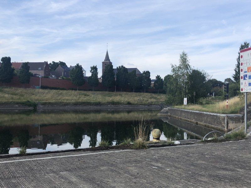
You can move into your night's quarters free of charge directly at the harbor basin at the foot of a ship lift. Walks along the canals are a nice way to compensate for a long journey.
Rue du Port de Plaisance 7070, 7070 Le Rœulx, Belgien
50° 28' 6.4" N 4° 5' 13" E
50.4684358 4.0869367
• Head northeast. Go for 844 m.
• Turn left onto Pont Henry Henrard. Go for 275 m.
• Turn right onto Rue des Écoles. Go for 174 m.
• Turn left onto Rue des Écoles. Go for 468 m.
• Continue on Rue des Hauts Bois. Go for 1.4 km.
• Turn right onto Chaussée de Mons (N538). Go for 373 m.
• Turn right and take ramp onto E19/E42 toward Paris/Mons. Go for 25.4 km.
• Keep left onto E19 toward Paris/Valenciennes. Go for 7.4 km.
• Continue on A2. Go for 77.7 km.
• Continue on A1 (Autoroute du Nord). Go for 17.7 km.
• Take the exit toward E44/A29/Reims/Rouen/St Quentin/Amiens. Go for 1.5 km.
• Take the exit toward Amiens/Rouen/Paris-Ouest onto A29. Go for 33.0 km.
• Take the left exit toward Rouen/Calais/Paris/Amiens-Centre/Amiens-Sud onto A29 (Viaduc de l'Avre). Go for 10.9 km.
• Take the left exit toward Beauvais/Cergy-Pontoise/Paris onto A16 (L'Européenne). Go for 52.9 km.
• Take exit 14 toward Beauvais-Sud/Rouen/Mantes la J./Cergy P./Paris/Méru/Gisors/Warluis onto D1001. Go for 1.6 km.
• Take the 1st exit from roundabout onto N31 toward Rouen/Mantes la J./Gisors/Méru/Beauvais/Z.A. de Avelon/Z.I. de Warluis. Go for 9.6 km.
• Take ramp toward Évreux/Gisors/Auneuil. Go for 261 m.
• Take the 2nd exit from roundabout onto D981 toward Évreux/Auneuil/Gisors. Go for 246 m.
• Pass 3 roundabouts and continue on Lieu-dit Le Point du Jour (D981). Go for 9.4 km.
• Continue on D981. Go for 3.7 km.
• Pass 3 roundabouts and continue on D981. Go for 9.4 km.
• Take the 2nd exit from roundabout onto D15 B toward Magny en Vexin. Go for 891 m.
• Take the 2nd exit from roundabout onto D14 B toward Vernon/Évreux/Fleury S/A. Go for 770 m.
• Take the 3rd exit from roundabout onto Rue Pierre Durand (D181) toward Courcelles. Go for 1.4 km.
• Continue on Lieu-dit Murs de Vaux (D981). Go for 4.5 km.
• Continue on Voie Louis XIII (D181). Go for 1.1 km.
• Take the 3rd exit from roundabout onto D181 toward Vernon/Vesly. Go for 6.4 km.
• Turn right onto Rue des Tilleuls (D6014) toward Rouen/Les Andelys/Fleury S/A. Go for 3.1 km.
• Turn left onto D125 toward Mouflaines/Les Andelys. Go for 10.2 km.
• Take the 1st exit from roundabout onto Rue du Maréchal Foch (D125). Go for 3.0 km.
• Turn left onto Rue Cheneaux de Leyritz (D313). Go for 825 m.
• Take the 3rd exit from roundabout onto Rue Gilles Nicolle (D313). Go for 151 m.
• Turn right. Go for 101 m.
• Turn right. Go for 37 m.
• Arrive at your destination on the right.
☍
297,0 km
(3 hrs. 5 min.)
Day
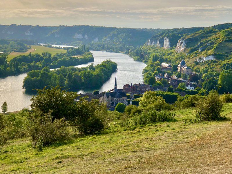
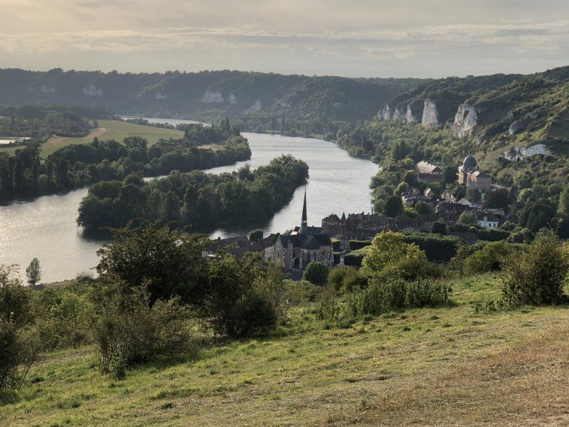
Flower Camping l'Ile des Trois Rois
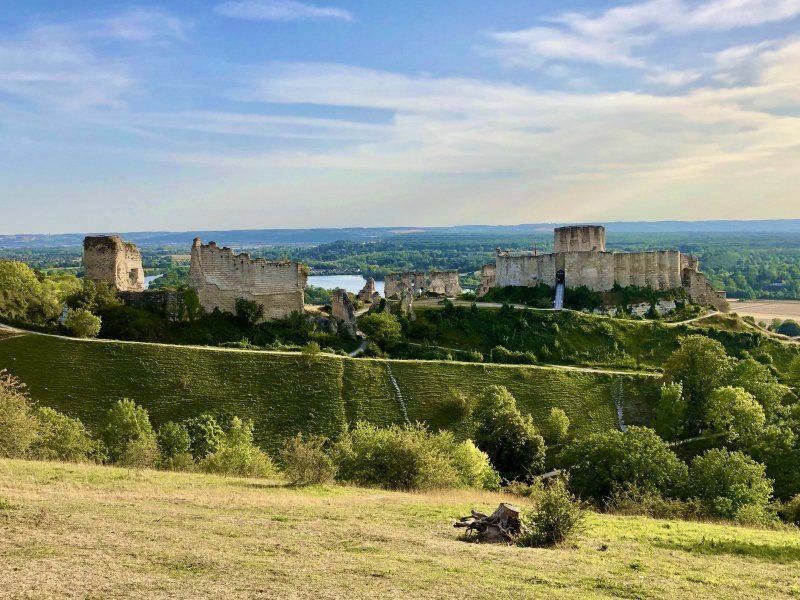
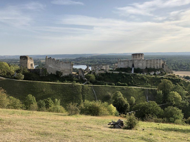
Château Gaillard an impressive castle ruin with a magnificent view over the Seine area.
The Trois Rois campsite is located directly on the Seine. The pool was loved by children. In addition to cafes and restaurants, the town of Les Andelys also offers Notre-Dame des Andelys.
gilles nicolle 1, 27700, Les Andelys, Frankreich
49° 14' 10" N 1° 24' 1.1" E
49.2361000 1.4003000
• Head south. Go for 37 m.
• Turn left. Go for 61 m.
• Turn left toward Rue du Pont/D135. Go for 96 m.
• Take the 3rd exit from roundabout onto Rue du Pont (D135). Go for 1.3 km.
• Pass 2 roundabouts and continue on D135. Go for 12.7 km.
• Take the 1st exit from roundabout onto Route Nationale (D6015) toward A13/Rouen/Pt de l'Arche/Val de Reuil/Louviers. Go for 1.1 km.
• Take the 3rd exit from roundabout onto Route de Louviers (D6155) toward Louviers. Go for 257 m.
• Take ramp onto A13 (Autoroute de Normandie). Go for 130 km.
• Take the exit toward Alençon/Rennes/Cherbourg onto N513 (Porte de Paris). Go for 964 m.
• Take ramp onto Périphérique (N513/N814). Go for 12.7 km.
• Take ramp onto A84 toward Le Mt-St-Michel/Rennes/Vire. Go for 91.0 km.
• Continue on N175. Go for 10.6 km.
• Take ramp onto N175 toward St Brieuc/St Malo/Le Mont-St Michel/Pontorson. Go for 13.2 km.
• Keep left onto N176. Go for 51.6 km.
• Take ramp toward Lorient/Vannes/Broons/Caulnes/Plancoët/Corseul. Go for 249 m.
• Take the 2nd exit from roundabout onto Route de Corseul (D794). Go for 11.4 km.
• Pass 2 roundabouts and continue on Rue de l'Abbaye (D794). Go for 1.9 km.
• Take the 2nd exit from roundabout onto Rue du Pont (D768). Go for 254 m.
• Take the 2nd exit from Rue du Pont roundabout onto Rue Marie-Paule Salonné. Go for 60 m.
• Turn left onto Rue Saint-Sauveur. Go for 188 m.
• Continue on Rue de la Courberie. Go for 364 m.
• Take the 3rd exit from roundabout onto Rue du Docteur Calmette. Go for 267 m.
• Turn right onto Rue de la Madeleine (D768). Go for 937 m.
• Take the 1st exit from roundabout onto D17. Go for 921 m.
• Take the 2nd exit from roundabout onto Rue Chateaubriand (D17). Go for 15.0 km.
• Turn right onto Rue du Dôme (D52). Go for 246 m.
• Take the 2nd exit from roundabout onto Rue des Écoles (D68). Go for 498 m.
• Continue on Route d'Erquy (D68). Go for 1.0 km.
• Continue on D68. Go for 30 m.
• Continue on Route d'Erquy (D68). Go for 1.3 km.
• Continue on D68. Go for 4 m.
• Turn left toward Lieu-dit Les Landes. Go for 835 m.
• Continue on Lieu-dit Les Landes. Go for 121 m.
• Continue on C14. Go for 86 m.
• Turn left onto D786. Go for 1.6 km.
• Turn right onto Rue du 3 Août 1944 (D34) toward Erquy. Go for 585 m.
• Arrive at D34.
☍
363,7 km
(3 hrs. 38 min.)
Day
Yelloh! Village Les Pins
Here we will move into quarters for the next 5 days. Really well-equipped campsite with a varied pool area directly 20 meters from the pitch - just the thing for the two kids.
On the following days we will explore the area from here.
22430, Erquy, Frankreich
48° 36' 8.9" N 2° 28' 7.1" W
48.6024764 -2.4686489
• Head toward Route de Combault on D34. Go for 3.8 km.
• Turn left onto Rue Foch. Go for 338 m.
• Take the 2nd exit from roundabout onto Rue Foch. Go for 434 m.
• Take the 3rd exit from roundabout onto Rue de Tu-Ès-Roc. Go for 397 m.
• Turn right onto Rue Hamel. Go for 121 m.
• Turn sharp left onto Rue du Four à Boulets. Go for 1.6 km.
• Arrive at your destination.
☍
6,6 km
( 12 min.)
Day
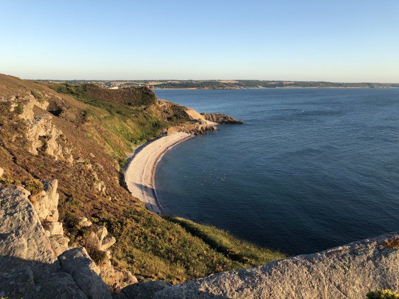
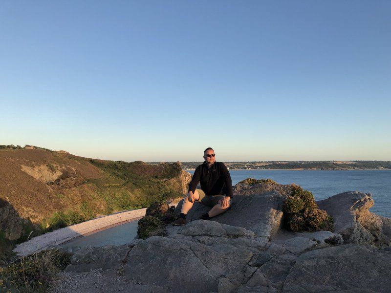
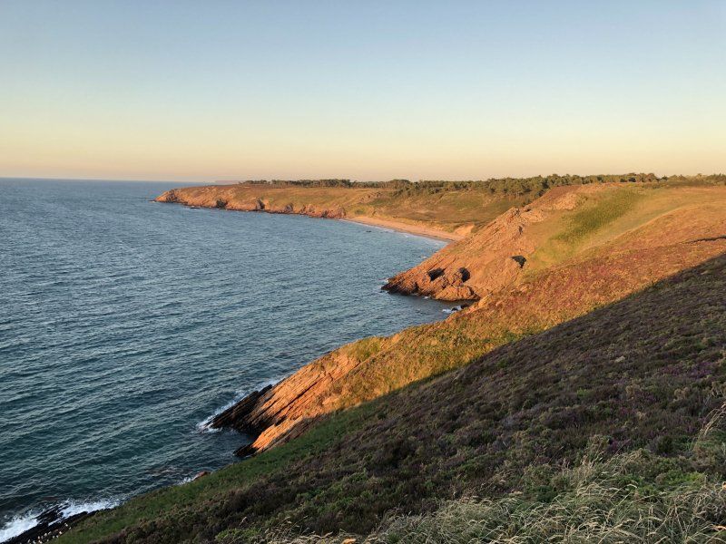
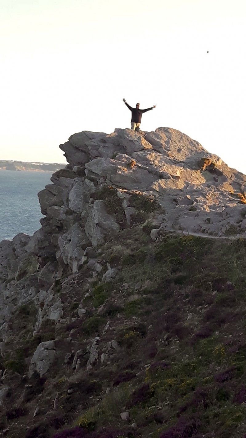
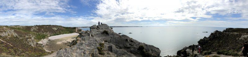
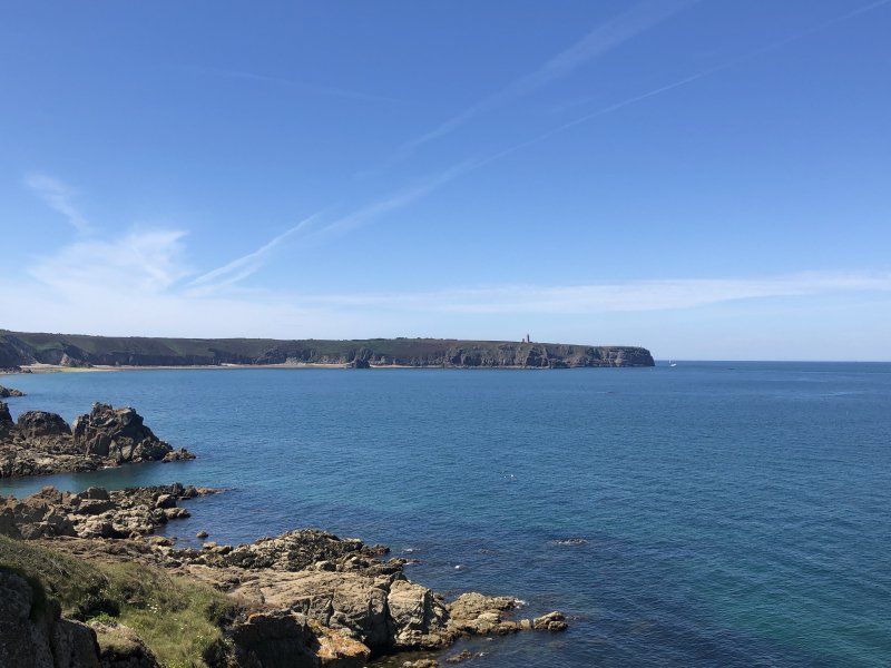
Cap d'Erquy, Frankreich
On the headland of Erquy you will find cliffs and lonely sandy bays. These can be discovered via hiking trails as well as bike paths.
48° 38' 43.2" N 2° 29' 20.8" W
48.6453200 -2.4891240
• Head southeast. Go for 305 m.
• Turn slightly left onto Rue du Four à Boulets. Go for 1.3 km.
• Turn sharp right onto Rue Hamel. Go for 121 m.
• Turn left onto Rue de Tu-Ès-Roc. Go for 372 m.
• Take the 2nd exit from roundabout onto Rue Foch. Go for 430 m.
• Take the 2nd exit from roundabout onto Rue Foch. Go for 142 m.
• Turn left onto Rue Fleurie. Go for 107 m.
• Turn slightly right onto Place du Nouvel Oupeye. Go for 28 m.
• Turn left onto Rue du 19 Mars 1962. Go for 123 m.
• Turn left onto Rue Clemenceau (D34). Go for 730 m.
• Continue on Rue du Château d'Eau. Go for 17 m.
• Turn right onto Rue du Château d'Eau (D34). Go for 1.4 km.
• Take the 3rd exit from roundabout onto Rue de Quélard (D786) toward Fréhel/Matignon/Dinard/Plurien/Sables d'Or les Pins/La Bouillie/Cap Fréhel/Fort la Latte. Go for 2.0 km.
• Pass 2 roundabouts and continue on Rue de la Grande Abbaye (D786). Go for 5.4 km.
• Turn left onto Lieu-dit Saint-Aide (D34) toward Plévenon/Cap Fréhel/Fort la Latte. Go for 2.7 km.
• Turn right onto D16 A. Go for 1.2 km.
• Continue on Lieu-dit Les Noës (D16 A). Go for 122 m.
• Continue on D16 A. Go for 293 m.
• Continue on Rue du Château Serein (D16 A). Go for 3.1 km.
• Arrive at Rue de la Latte. Your destination is on the left.
☍
19,7 km
( 30 min.)
Day
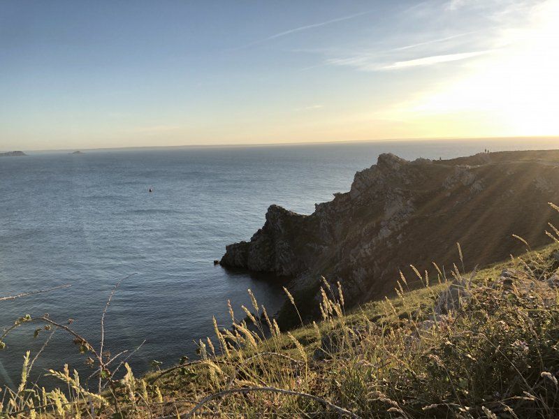
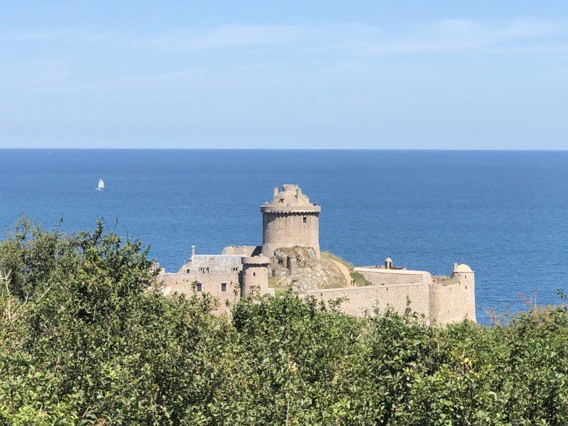
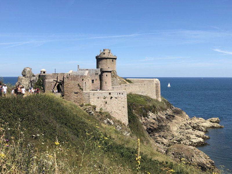
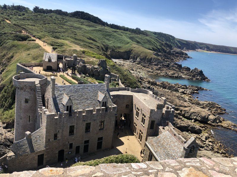
Fort La Latte
Well-preserved fortress on the cliffs with a great view.
22240
48° 40' 4.2" N 2° 17' 10" W
48.6678297 -2.2861017
• Head southwest on Rue de la Latte. Go for 648 m.
• Turn left toward Rue de la Latte/D16 A. Go for 238 m.
• Turn left onto Rue de la Latte (D16 A). Go for 2.3 km.
• Continue on D16 A. Go for 293 m.
• Continue on Lieu-dit Les Noës (D16 A). Go for 122 m.
• Continue on D16 A. Go for 1.1 km.
• Turn left onto Rue du Petit Trécelin (D34). Go for 2.8 km.
• Turn right onto D786. Go for 1.3 km.
• Pass 2 roundabouts and continue on D786. Go for 5.9 km.
• Take the 3rd exit from roundabout onto Rue du Poteau Bleu (D786) toward Pléneuf-Val-André/Lamballe/St Brieuc. Go for 4.0 km.
• Turn left onto Rue du 3 Août 1944 (D786) toward Pléneuf-Val-André/Lamballe/St Brieuc/Château de Bien-Assis. Go for 2.4 km.
• Take the 2nd exit from roundabout onto Route de la Libération (D34) toward Pléneuf-Val-André. Go for 2.3 km.
• Take the 3rd exit from roundabout onto Rue d'Erquy (D34). Go for 208 m.
• Turn right onto Place de Lourmel (D34). Go for 1.1 km.
• Take the 2nd exit from roundabout onto Rue des Saules. Go for 241 m.
• Turn right onto Rue du Minihy. Go for 809 m.
• Take the 3rd exit from roundabout onto Rue du Port (D34). Go for 614 m.
• Turn right onto Quai des Terre-Neuvas. Go for 508 m.
• Arrive at Quai des Terre-Neuvas. Your destination is on the left.
☍
27,0 km
( 32 min.)
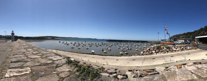
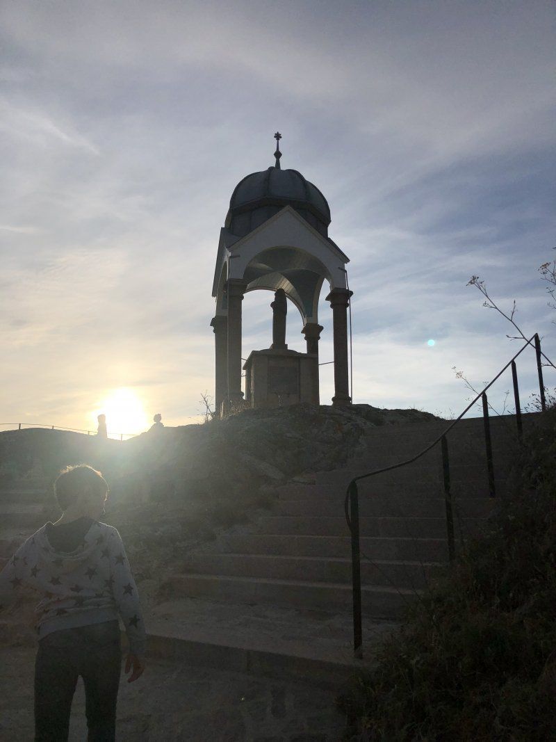
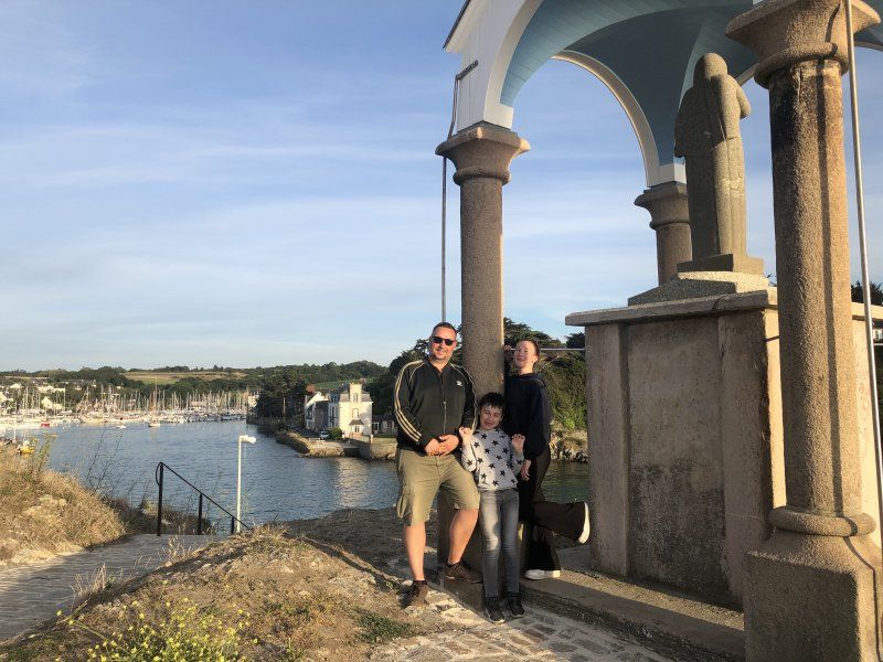
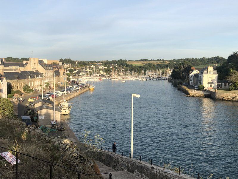
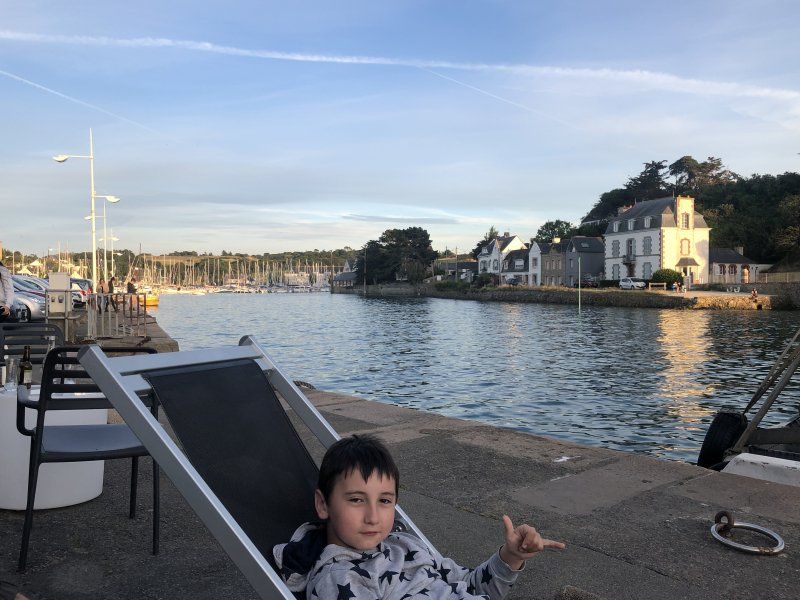
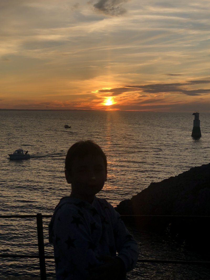
Oratoire Notre-Dame-de-La-Garde
The oratory of Mary at the port entrance certainly protects the seafarers. Here you can enjoy a wonderful view of the coast, the sea and the sunset. The ebb and flow of the tide is nice to watch at the harbor. There are several small restaurants right by the harbor. The sunset literally shines into the harbor and illuminates the old buildings in warm light.
74 Quai des Terre-Neuvas
48° 34' 43.9" N 2° 34' 11.2" W
48.5788595 -2.5697706
• Head toward Rue des Islandais on Quai des Terre-Neuvas. Go for 487 m.
• Turn right onto Rue du Pont Neuf (D34). Go for 2.8 km.
• Take the 2nd exit from roundabout onto Rue de la Gaieté (D34). Go for 518 m.
• Take the 3rd exit from Rond-Point du Poirier roundabout onto Rue de l'Ormelet (D791) toward Lamballe. Go for 8.6 km.
• Take the 2nd exit from roundabout onto D768. Go for 2.7 km.
• Take the 2nd exit from roundabout onto C58. Go for 485 m.
• Take the 3rd exit from roundabout onto N12. Go for 74.9 km.
• Take ramp onto N1012 toward Rennes-Centre/C.H.U. Pontchaillou/Rocade Sud/Angers/Nantes. Go for 2.0 km.
• Take ramp onto Rocade Ouest (N136) toward Angers/Nantes. Go for 6.2 km.
• Take ramp onto N137 toward Porte de Nantes/Nantes/Noyal-Châtillon/Bain de Bgne. Go for 95.8 km.
• Take ramp onto A821/A844 (Périphérique Nord) toward Périphérique-Ouest/Bordeaux/Vannes/Noirmoutier/Orvault/Aéroport Nantes-Atlantique. Go for 2.5 km.
• Keep left onto Périphérique Ouest (N844) toward Noirmoutier/Bordeaux/Aéroport Nantes-Atlantique. Go for 9.5 km.
• Take ramp onto M723 toward D723/Noirmoutier/St Brevin les Pins/Pornic/Bouguenais-Centre/Porte de Bouguenais. Go for 610 m.
• Keep left onto Route de Pornic (M723) toward D723/Noirmoutier/La Montagne/Pornic/St Brevin. Go for 5.1 km.
• Take ramp onto M751 toward Noirmoutier/Bouaye-les Côteaux/Port St Père/Machecoul/Pornic/Planète Sauvage. Go for 7.2 km.
• Continue on D751. Go for 1.3 km.
• Take ramp toward Noirmoutier/Ste Pazanne/Bourgneuf en R./Port St Père/Machecoul/Planète Sauvage. Go for 392 m.
• Take the 2nd exit from roundabout onto D758. Go for 361 m.
• Take the 2nd exit from roundabout onto D758 toward Noirmoutier/Planète Sauvage/Machecoul/Ste Pazanne/Bourgneuf en R. Go for 3.8 km.
• Turn left onto Lieu-dit Tournebride (D95) toward Machecoul/La Métairie d'Ardennes. Go for 3.1 km.
• Take the 2nd exit from roundabout onto D95. Go for 9.1 km.
• Take the 3rd exit from Rond-Point des Carrières roundabout onto Boulevard de l'Atlantique (D13) toward La Roche S/Yon/La Rochelle/Challans/Legé/St Philbert de Gd Lieu/Z.I. la Seiglerie. Go for 1.5 km.
• Take the 2nd exit from Rond-Point de la Forêt roundabout onto D13 toward La Roche S/Yon/La Rochelle/Challans/Legé/St Philbert de Gd Lieu. Go for 984 m.
• Take the 2nd exit from Rond-Point du Moulin Mocrat roundabout onto Route de Challans (D95) toward La Roche S/Yon/La Rochelle/Challans/Z.I. la Seiglerie. Go for 1.3 km.
• Take the 2nd exit from Rond-Point de la Seiglerie roundabout onto Route de Challans (D95) toward La Roche S/Yon/La Rochelle/La Garnache/Challans. Go for 3.6 km.
• Continue on D32. Go for 1.9 km.
• Take the 4th exit from roundabout onto D32 toward La Roche S/Yon/La Rochelle/La Garnache/Challans/Château de la Garnache. Go for 8.5 km.
• Keep left onto D32 toward D948/Noirmoutier/Beauvoir/St Jean de Monts/St Gilles/St Hilaire. Go for 602 m.
• Continue on D948. Go for 2.1 km.
• Keep left onto D205. Go for 3.7 km.
• Pass 2 roundabouts and continue on D205. Go for 6.1 km.
• Take the 3rd exit from roundabout onto Route du Pissot (D59). Go for 4.2 km.
• Take the 2nd exit from Route du Perrier roundabout onto Route du Perrier (D59). Go for 3.1 km.
• Take the 2nd exit from Rond-Point du Pissot roundabout onto Route du Pissot (D38). Go for 1.2 km.
• Turn right onto Route du Pissot (D38). Go for 770 m.
• Take the 2nd exit from Rond-Point du Puits Tarraud roundabout onto Avenue de la Rousselotière (D38). Go for 518 m.
• Take the 1st exit from roundabout onto Avenue de la Faye (D6). Go for 538 m.
• Turn left onto Avenue de la Forêt (D6). Go for 1.3 km.
• Turn right onto Avenue des Mimosas (D123). Go for 1.0 km.
• Take the 3rd exit from roundabout onto Allée de la Plage de Riez. Go for 373 m.
• Arrive at Allée de la Plage de Riez.
☍
281,0 km
(2 hrs. 58 min.)
Day
Day
Day
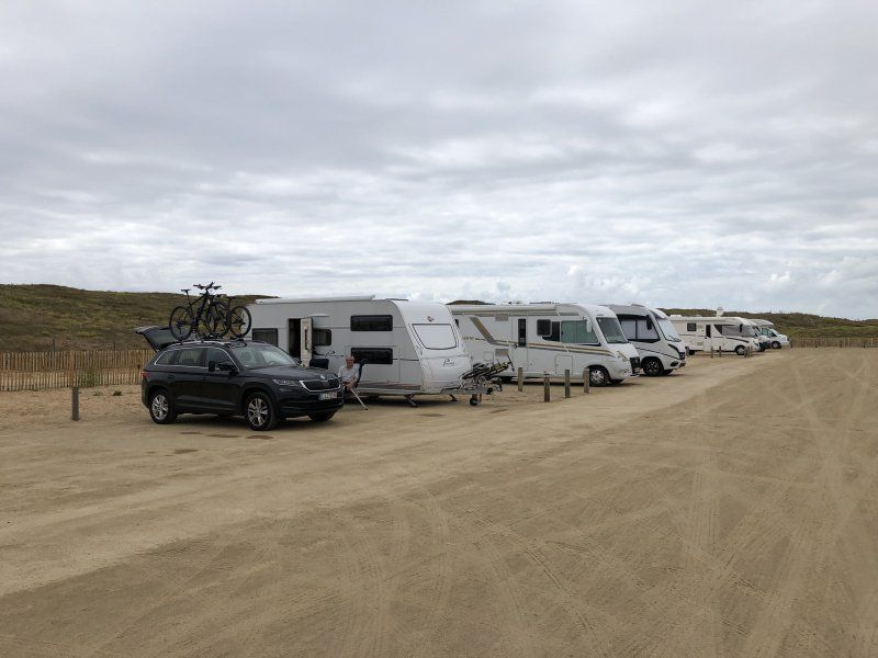
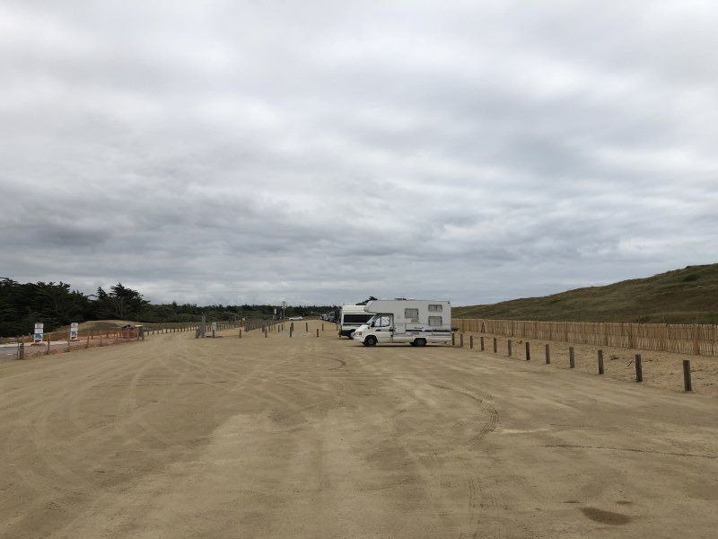
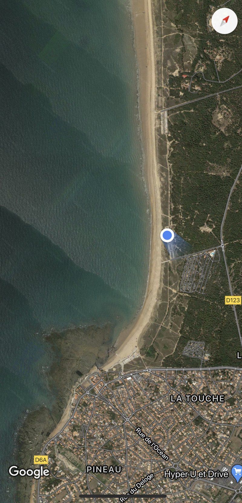
Allée de la Plage de Riez, 85270 Saint-Hilaire-de-Riez, Frankreich
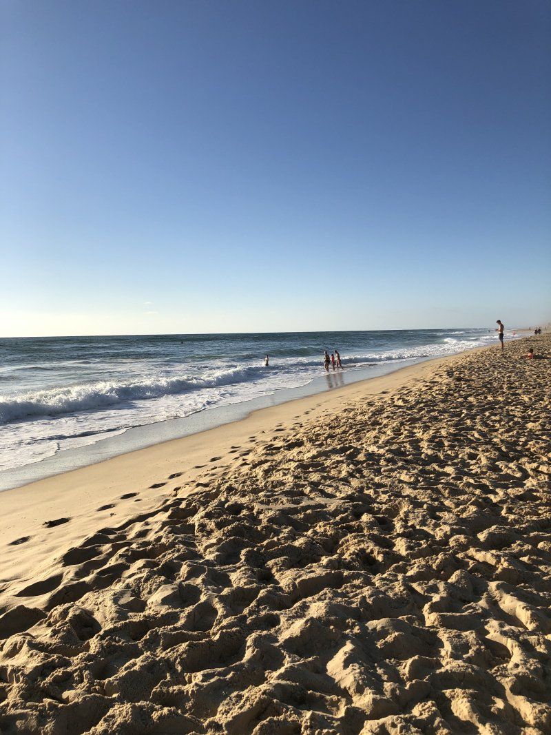
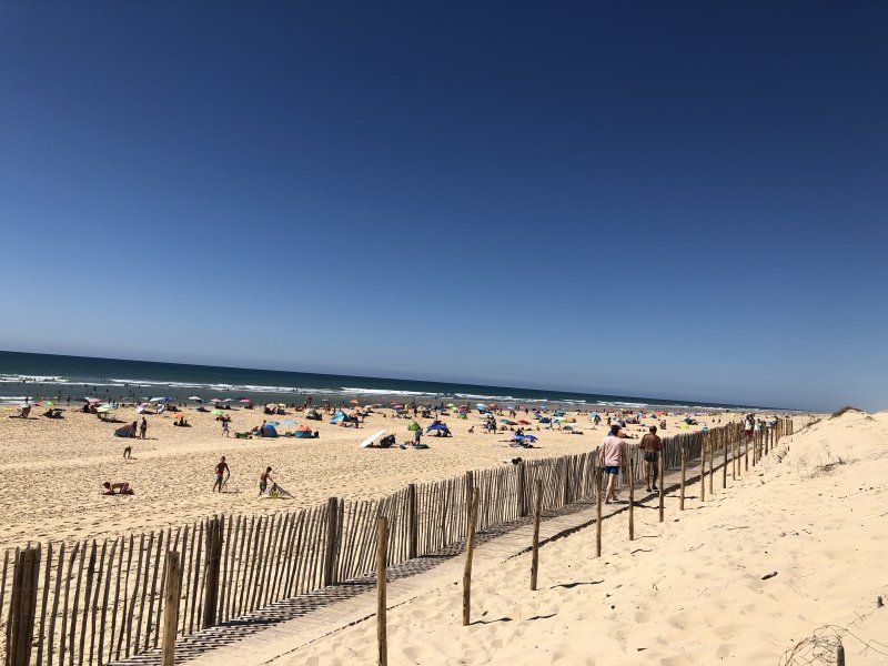
A brand new pitch directly behind the dunes on the Atlantic.
Top pitch !!!
... to fall asleep and wake up wonderfully with the roaring surf.
46° 43' 17.5" N 1° 58' 51.2" W
46.7215265 -1.9808777
• Head northeast on Allée de la Plage de Riez. Go for 331 m.
• Take the 1st exit from roundabout onto Avenue des Mimosas (D123). Go for 997 m.
• Turn left onto Avenue de la Forêt (D6). Go for 1.3 km.
• Continue on Avenue de la Faye (D6). Go for 518 m.
• Take the 3rd exit from roundabout onto Avenue de la Rousselotière (D38). Go for 500 m.
• Take the 1st exit from Rond-Point du Puits Tarraud roundabout onto D38 BIS. Go for 1.4 km.
• Take the 3rd exit from Rond-Point des Marais Salants roundabout onto D38 BIS. Go for 1.3 km.
• Take the 2nd exit from Rond-Point des Mares roundabout onto D38 BIS. Go for 574 m.
• Take the 3rd exit from Rond-Point des Pompiers roundabout onto D38 BIS. Go for 436 m.
• Pass 2 roundabouts and continue on D38 BIS. Go for 1.7 km.
• Take the 3rd exit from Rond-Point de l'Europe roundabout onto Route de la Roche (D6). Go for 419 m.
• Pass 7 roundabouts and continue on D6. Go for 15.3 km.
• Take the 3rd exit from roundabout onto D6. Go for 8.6 km.
• Take the 2nd exit from roundabout onto D948 toward La Roche S/ Yon. Go for 2.4 km.
• Take the 2nd exit from roundabout onto D948 toward A87/La Roche S/Yon/La Rochelle/La Genétouze/Venansault/Z.I. les Blussières. Go for 12.1 km.
• Take the 4th exit from Rond-Point de l'Atlantique roundabout onto Rue des Terres Noires (D160) toward La Rochelle/Cholet/Les Terres Noires. Go for 4.4 km.
• Keep left onto D948. Go for 20.4 km.
• Take the 3rd exit from roundabout toward Nantes/Angers/Bordeaux/Poitiers/Niort. Go for 139 m.
• Take ramp onto A83 toward Poitiers/Niort/Bordeaux. Go for 81.6 km.
• Take the exit toward E5/Bordeaux/Saintes/Limoges/Angoulême onto A10 (Échangeur Niort-Nord). Go for 179 km.
• Continue on A630 toward Aéroport Mérignac/Bordeaux-Lac. Go for 12.6 km.
• Take exit 8 toward Le Verdon S/ Mer/Lacanau/St Médard en Jalles/Eysines-Centre onto D1215. Go for 1.4 km.
• Pass 3 roundabouts and continue on Route de Lacanau (D1215). Go for 3.4 km.
• Take the 2nd exit from roundabout onto Route de Lacanau (D1215) toward Le Verdon S/Mer/Lacanau/St Médard/St Aubin de M. Go for 1.3 km.
• Pass 3 roundabouts and continue on D1215. Go for 2.4 km.
• Take the 3rd exit from roundabout onto D1215 toward Lacanau/Ste Hélène. Go for 1.6 km.
• Take the 3rd exit from roundabout onto Route de Lacanau (D1215) toward Salaunes/Lacanau. Go for 7.5 km.
• Pass 2 roundabouts and continue on D6. Go for 20.3 km.
• Take the 1st exit from roundabout onto D6 toward Lacanau Océan/Carcans/Brach/Royan Par Pointe de Grave/Route des Lacs. Go for 371 m.
• Pass 2 roundabouts and continue on D6. Go for 2.8 km.
• Take the 1st exit from roundabout onto Avenue de l'Océan (D6) toward Le Moutchic/Lacanau-Océan/Réserve Naturelle de l'Étang de Cousseau. Go for 1.3 km.
• Continue on D6. Go for 1.7 km.
• Take the 1st exit from roundabout onto D6. Go for 3.5 km.
• Continue on Route de l'Atlantique (D6). Go for 1.4 km.
• Take the 2nd exit from roundabout onto D6. Go for 569 m.
• Take the 2nd exit from roundabout onto Boulevard Docteur Fromaget. Go for 1.4 km.
• Turn right onto Avenue des Grands Pins. Go for 518 m.
• Arrive at Avenue des Grands Pins. Your destination is on the left.
☍
398,0 km
(3 hrs. 54 min.)
Day
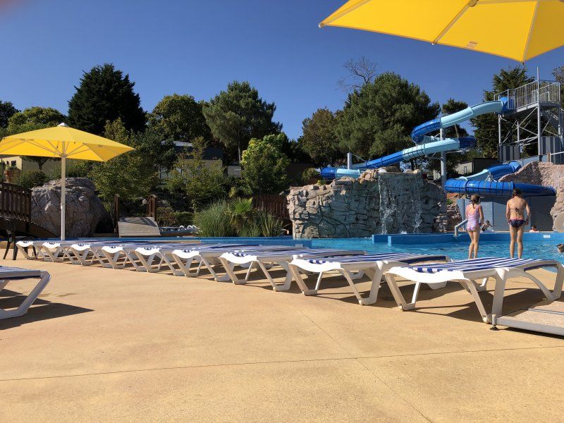
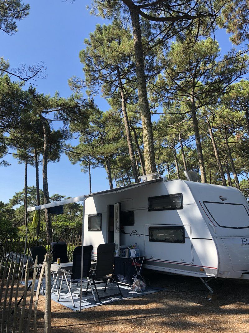
Camping Les Grands Pins, Lacanau, Frankreich
Large campsite right on the Atlantic. Clearly - a surf spot. Swimming pools, bistros, and supermarkets can be found as well as tennis courts and a small skate park. The parking spaces are quite narrow and close together. But it is shady under the tall pines.
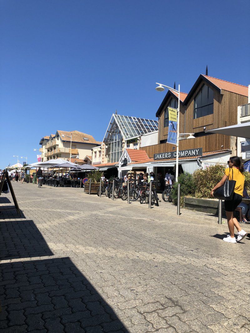
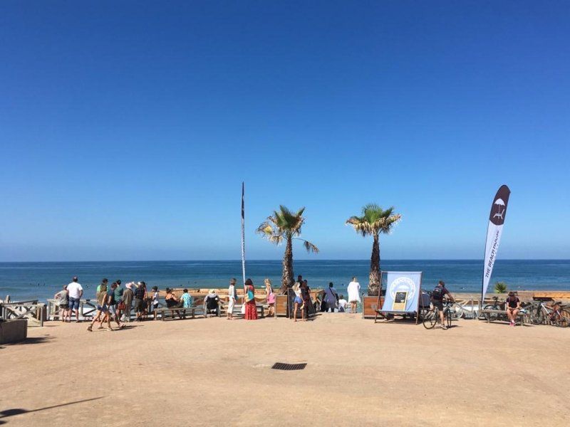
Lacanau-Océan is a small town with a number of restaurants, sports shops and surf shops.
33680 Lacanau, Frankreich
45° 0' 42.8" N 1° 11' 39.7" W
45.0118919 -1.1943487
• Head south on Avenue des Grands Pins. Go for 50 m.
• Turn slightly right onto Avenue des Grands Pins. Go for 468 m.
• Turn left onto Boulevard du Maréchal Louis Franchet d'Espérey. Go for 1.3 km.
• Take the 3rd exit from roundabout onto D6. Go for 622 m.
• Take the 2nd exit from roundabout. Go for 89 m.
• Continue on Route de l'Atlantique (D6). Go for 1.4 km.
• Continue on D6. Go for 3.4 km.
• Take the 3rd exit from roundabout onto D6. Go for 1.8 km.
• Continue on Lieu-dit Talaris (D6). Go for 1.2 km.
• Take the 3rd exit from roundabout onto D6 toward A63/Carcans/Le Porge/Lège-Cap Ferret/Bordeaux. Go for 1.0 km.
• Pass 2 roundabouts and continue on D6. Go for 2.1 km.
• Take the 2nd exit from roundabout onto Avenue de Bordeaux (D6) toward A63/Sainte Héléne/Bordeaux. Go for 16.5 km.
• Pass 7 roundabouts and continue on Route de Lacanau (D1215). Go for 16.6 km.
• Take the 1st exit from roundabout onto Route de Lacanau (D1215) toward Rocade/Eysines/Bordeaux/P+R. Go for 1.4 km.
• Pass 3 roundabouts and continue on D1215. Go for 3.1 km.
• Take left ramp onto A630 (Rocade de Bordeaux) toward Paris/A10/Lyon/A89/Bordeaux. Go for 13.0 km.
• Take exit 1 toward E70/Lyon/Périgueux/Bergerac/Libourne onto N230 (Rocade de Bordeaux). Go for 1.7 km.
• Take ramp toward Lyon/A89/Périgueux/Bergerac/Libourne/Hôpital Bordeaux Rive Droite/P+R/P+R Tram A. Go for 369 m.
• Turn left onto N89. Go for 18.5 km.
• Keep left onto A89 toward Lyon/Périgueux/Bergerac/Libourne-Nord. Go for 167 km.
• Take the left exit toward Paris/Limoges/Lyon/A89/Clermont-Fd/Tulle/Brive-Est onto A20 (L'Occitane). Go for 16.7 km.
• Take exit 46.1 toward Lyon/Clermont-Fd/Tulle/St-Germain les V. onto A89. Go for 161 km.
• Take the left exit toward E11/Paris/Montluçon/Vichy onto A71. Go for 46.6 km.
• Take exit 11 toward E62/Moulins/Bourbon l'Arch. onto A79. Go for 66.7 km.
• Take exit 25 toward Bourbon-Lancy/Diou. Go for 581 m.
• Continue toward Route de Dompierre/D779. Go for 51 m.
• Take the 3rd exit from roundabout onto Route de Dompierre (D779). Go for 2.3 km.
• Turn left onto Route de Gilly (D480). Go for 1.1 km.
• Continue on D480. Go for 310 m.
• Turn left onto D979. Go for 7.0 km.
• Turn right onto Lieu-dit La Cornière (D979 A) toward Bourbon-Lancy-Centre. Go for 2.1 km.
• Turn left onto Rue des Sables. Go for 957 m.
• Take the 2nd exit from roundabout onto Rue des Eurimants. Go for 287 m.
• Turn right toward Rue des Eurimants. Go for 60 m.
• Turn right onto Rue des Eurimants. Go for 119 m.
• Arrive at Rue des Eurimants. Your destination is on the right.
☍
557,4 km
(5 hrs. 15 min.)
Day
Day
Day
Day
Day
Day
Day
Day
Day
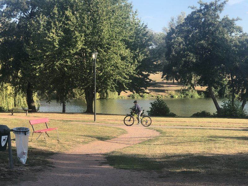
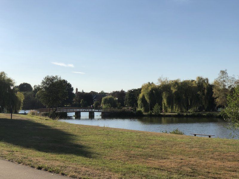
Camping du Breuil
A really nice, small campsite with a pool and a very friendly welcome. When we arrived there was a market right on the square: regional vegetables, jams, cakes and goat's milk products. Delicious.
There is a small lake next to the campsite that is easy to round. In addition to fitness trails, there is also a skate park, a playground and the supermarket can also be reached quickly.
Rue des Eurimants 11, 71140, Bourbon Lancy, Frankreich
46° 37' 10.2" N 3° 45' 18" E
46.6195000 3.7550000
• Head southwest on Rue des Eurimants. Go for 119 m.
• Turn right toward Rue des Eurimants. Go for 44 m.
• Turn right onto Rue des Eurimants. Go for 584 m.
• Continue on Rue des Forges. Go for 101 m.
• Turn right onto Avenue Émile et Claude Puzenat (D973). Go for 1.2 km.
• Continue on Avenue de la République (D979 A) toward St Aubin S/L./Digoin. Go for 467 m.
• Turn right onto Place de la République (D973). Go for 15 m.
• Take the 3rd exit from roundabout onto Avenue Général de Gaulle (D973) toward Autun/Gueugnon. Go for 402 m.
• Turn right onto Rue des Prébendés (D60) toward Chalmoux/Gueugnon. Go for 24.5 km.
• Take the 2nd exit from roundabout onto Rue Jean Bouveri (D60). Go for 593 m.
• Take the 1st exit from roundabout onto Place de l'Église. Go for 50 m.
• Turn slightly right onto Place de l'Église. Go for 145 m.
• Turn left onto Quai de l'Europe. Go for 65 m.
• Continue on Quai de l'Europe. Go for 398 m.
• Turn right onto Rue de la Liberté (D60). Go for 154 m.
• Turn left onto Rue Danton (D60). Go for 242 m.
• Take the 3rd exit from roundabout onto Route de Perrecy (D60). Go for 3.7 km.
• Continue on D60. Go for 175 m.
• Continue on Lieu-dit Le Rêvetela (D60). Go for 88 m.
• Continue on D60. Go for 129 m.
• Continue on Lieu-dit Le Rêve (D60). Go for 134 m.
• Continue on D60. Go for 220 m.
• Continue on Lieu-dit Le Bois Rond (D60). Go for 109 m.
• Continue on D60. Go for 1.3 km.
• Continue on Lieu-dit Les Carrouges (D60). Go for 77 m.
• Continue on D60. Go for 137 m.
• Continue on Lieu-dit Cult du Bonhomme (D60). Go for 132 m.
• Continue on D60. Go for 4.2 km.
• Continue on Lieu-dit Cercy (D60). Go for 173 m.
• Continue on D60. Go for 188 m.
• Continue on Lieu-dit Le Grand Champ (D60). Go for 155 m.
• Continue on D60. Go for 1.4 km.
• Take the 2nd exit from roundabout onto D60. Go for 2.6 km.
• Take left ramp onto N70 toward Montceau/Chalon/St Vallier. Go for 26.1 km.
• Take the 2nd exit from Rond-Point Jeanne Rose roundabout onto N80 toward A6/Chalon S/S./A6/Chalon. Go for 26.6 km.
• Take the 1st exit from Giratoire de Cortelin roundabout onto Route Express Chalon Montceau (N80) toward Chalon S/Saône. Go for 450 m.
• Turn right toward A6/Paris/Dijon/Lyon/Bourg en B./Mâcon. Go for 332 m.
• Take ramp onto A6 (Autoroute du Soleil) toward Paris/Dijon. Go for 31.1 km.
• Continue on A31. Go for 5.3 km.
• Take the exit toward Mulhouse/Besançon/Dole onto A36 (La Comtoise). Go for 164 km.
• Keep left onto A36 (La Comtoise) toward Strasbourg/Mulhouse/Belfort/Montbéliard. Go for 74.2 km.
• Continue on A5. Go for 191 m.
• Take the left exit toward Karlsruhe/Stuttgart/Freiburg onto A5. Go for 199 km.
• Take exit 40 toward Heilbronn onto A6. Go for 53.8 km.
• Take the exit toward Würzburg onto A81 (Autobahnkreuz Weinsberg). Go for 82.8 km.
• Take the exit toward Nürnberg/Kassel onto A3. Go for 14.3 km.
• Take exit 71 toward Ochsenfurt. Go for 527 m.
• Turn left onto B13 toward Ansbach/Ochsenfurt/München. Go for 787 m.
• Take ramp. Go for 172 m.
• Turn slightly left onto Mainparkring. Go for 600 m.
• Arrive at Mainparkring. Your destination is on the left.
☍
724,0 km
(6 hrs. 47 min.)
Day
Wassersportclub Eibelstadt
Mainparkring, 97246, Eibelstadt, Deutschland
49° 43' 52.7" N 9° 59' 14.3" E
49.7313000 9.9873000
• Head east on Mainparkring. Go for 169 m.
• Turn right onto Mainparkring. Go for 246 m.
• Turn left onto Brückenstraße. Go for 97 m.
• Continue on Würzburger Straße. Go for 138 m.
• Take the 3rd exit from roundabout onto B13 toward A3/Würzburg. Go for 778 m.
• Take ramp onto A3 toward Kassel/Nürnberg. Go for 6.3 km.
• Take the exit toward Kassel/Erfurt/Schweinfurt/Ulm/Rothenburg onto A7. Go for 33.3 km.
• Take exit 99 toward Bamberg/Schweinfurt/Werneck/Erfurt onto A70. Go for 119 km.
• Take left exit 26 toward Berlin/Dresden/Hof onto A9. Go for 296 km.
• Continue on A10 (Berliner Ring). Go for 10.3 km.
• Take exit 16 toward Berlin-Zentrum (Zoo)/Berlin-Zehlendorf/Potsdam-Zentrum onto A115 (Autobahndreieck Nuthetal). Go for 27.5 km.
• Take exit 1 toward Zentrum/Messedamm onto Halenseestraße. Go for 1.7 km.
• Continue on Messedamm. Go for 328 m.
• Continue on Messedamm. Go for 423 m.
• Turn right onto Kaiserdamm (B2/B5) toward Tiergarten/Zentrum. Go for 2.7 km.
• Take the 2nd exit from Ernst-Reuter-Platz roundabout onto Straße des 17. Juni (B2/B5) toward Mitte/Tiergarten/Flughafen. Go for 2.0 km.
• Take the 2nd exit from Großer Stern roundabout onto Straße des 17. Juni (B2/B5) toward Reichstag/Potsdamer Platz/Mitte. Go for 1.4 km.
• Turn left onto Yitzhak-Rabin-Straße toward Reichstag. Go for 244 m.
• Turn right onto Platz der Republik. Go for 421 m.
• Continue on Dorotheenstraße (B2). Go for 240 m.
• Turn right onto Wilhelmstraße (B2). Go for 164 m.
• Turn left onto Unter den Linden. Go for 1.2 km.
• Continue on Schloßbrücke (B2/B5). Go for 78 m.
• Continue on Am Lustgarten (B2/B5). Go for 477 m.
• Arrive at Karl-Liebknecht-Straße (B2/B5). Your destination is on the right.
☍
505,2 km
(4 hrs. 39 min.)
Day
Berlin, Deutschland
52° 31' 12" N 13° 24' 17.8" E
52.5200066 13.4049540