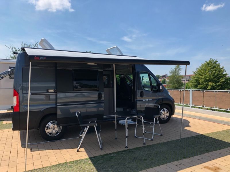
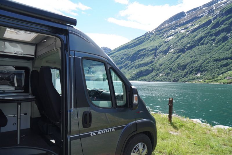
At the beginning of June 2019 we 🙋♀️🙋♂️ went on a big road trip in the 🚐💨 box van via 🇩🇰 Denmark to 🇳🇴 Norway. In total it was 🛣 4,665 KM in 19 days.
The journey to Fjord Norway begins with the ⛴️ ferry crossing between Hirtshals and Kristiansand. Along the 🐑 Jæren Coast it goes via Stavanger, the Saudafjord and 🍎 Hardangerfjord, over the Aurlandsfjellet and Sognefjellet to the ⛴ Geirangerfjord. Highlights are the visit of Stanvangers and Oslo's old town, our hike on Europe's largest ⛰️ mainland glacier Jostedalsbreen and the trip over the 😈 Trollstigen to Ålesund, before we return to Kristiansand on the ferry to Hirtshals.
You can also find our travel report on our 🎥 YouTube channel (https://tinyurl.com/ErstmalDurchEuropa) and also as a playlist (https://tinyurl.com/EdE-Norge).
Day
Wohnmobilhafen am Kanal-Café NOK
The first milestone is the NOK. This ideal of a mobile home port is within sight of the Rendsburger Hochbrücke. A cycling and hiking trail along the canal invites you to take a trip to Rendsburg, where you can linger at the canal café. With the landscaped terraces and summer temperatures, you can spend hours marveling at the Dickpötte as they pass through.
Am Kamp-Kanal 1, 24783 Osterrönfeld, Deutschland
54° 17' 26.3" N 9° 40' 18.2" E
54.2906340 9.6717270
• Head west. Go for 48 m.
• Continue on Am Kamp-Kanal. Go for 187 m.
• Turn slightly right onto Albert-Betz-Straße. Go for 82 m.
• Turn left onto Grüner Kamp (K27). Go for 594 m.
• Take the 1st exit from roundabout onto Zum Hafen (L255). Go for 897 m.
• Turn right and take ramp onto B202. Go for 3.3 km.
• Continue on A210. Go for 2.3 km.
• Take exit 3 toward Flensburg onto A7. Go for 65.0 km.
• Continue on E45 (Sønderjyske Motorvej). Go for 89.5 km.
• Keep left onto E45 (Kolding) toward Århus/Vejle. Go for 205 km.
• Keep right onto E39 (Vendsyssel) toward Hirtshals/Hjørring/Brønderslev/Høvejen/Thisted. Go for 33.4 km.
• Take exit 5 toward Vrå/Tårs/Løkken. Go for 379 m.
• Take the 3rd exit from roundabout onto Vrejlev Klostervej (593) toward Løkken/Vrå/Aalborg/E39. Go for 2.9 km.
• Take the 3rd exit from roundabout onto Vråvej (593). Go for 2.0 km.
• Take the 2nd exit from roundabout onto Vråvej (593). Go for 1.0 km.
• Turn right onto Vråvej. Go for 83 m.
• Continue on Smidstrupvej. Go for 711 m.
• Continue on Granlyvej. Go for 245 m.
• Continue on Smidstrupvej. Go for 5.8 km.
• Turn right onto Vejbyvej. Go for 3.5 km.
• Turn right onto Løkkensvej (55) toward Hjørring. Go for 1.6 km.
• Turn left onto Lønstrupvej toward Lønstrup. Go for 7.7 km.
• Continue on Strandvejen. Go for 562 m.
• Turn left onto Rubjergvej. Go for 325 m.
• Turn right onto Mårup Kirkevej. Go for 466 m.
• Arrive at Mårup Kirkevej. Your destination is on the left.
☍
428,0 km
(4 hrs. 20 min.)
Day
Mårup Kirke
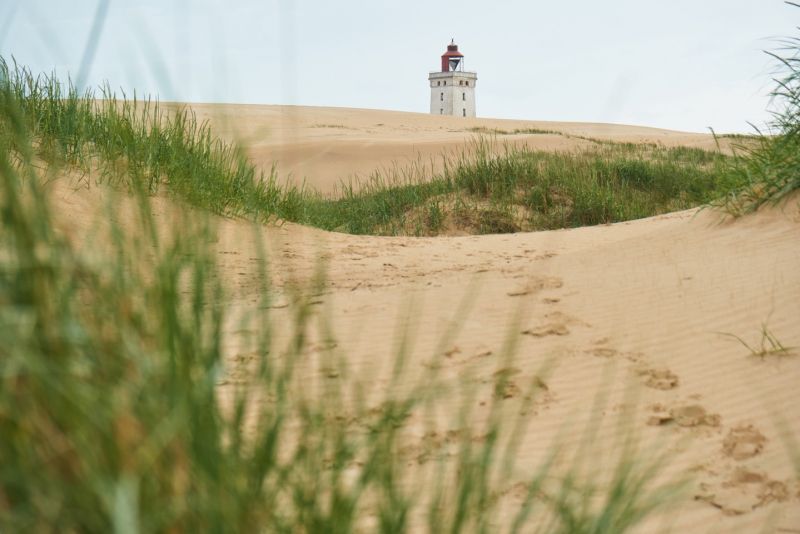
During our last night before the ferry crossing from Hirtshals to Kristiansand, we stand free at Lønstrup Klint, where Mårup Kirke once stood. From here you can see far beyond the cliffs to the open sea and the shifting dune Rubjerg Knude with the associated lighthouse. The sea is calm and the rain clouds are moving on, it will be a good last night in Denmark.
Mårup Kirkevej, 9800 Hjørring, Dänemark
57° 27' 47.3" N 9° 47' 31" E
57.4631479 9.7919433
• Head northeast on Mårup Kirkevej. Go for 466 m.
• Turn left onto Rubjergvej. Go for 325 m.
• Turn right onto Strandvejen. Go for 562 m.
• Continue on Lønstrupvej. Go for 1.5 km.
• Turn left onto Skallerupvej. Go for 8.4 km.
• Turn left onto Krustrupvej (55) toward Hirtshals. Go for 10.4 km.
• Turn right onto Søndre Ringvej (55) toward Hirtshals S. Go for 2.5 km.
• Turn left onto Dalsagervej (55) toward Hirtshals. Go for 934 m.
• Take the 4th exit from roundabout onto Aalborgvej (E39) toward Hirtshals/Havn. Go for 1.5 km.
• Keep left onto E39 toward Color Line/Check-in. Go for 783 m.
• Make a U-Turn at Hirtshals-Kristiansand onto E39. Go for 131 m.
• Arrive at E39. Your destination is on the right.
☍
27,5 km
( 32 min.)
Day
Color Line Terminal Hirtshals
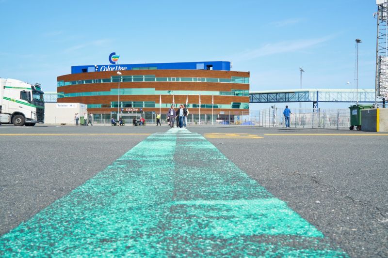
After a very good night in Denmark we reach our check in for our ferry to Kristiansand today. Good signage leads along the E39 to the Color Line terminal. Now we are waiting a good 1.5 hours before departure in row 23 for the arrival of the SuperSpeed 1. The weather is fantastic and the sea is calm, it will be a smooth trip across the Skagerrak.
9850 Hirtshals, Dänemark
57° 35' 34.1" N 9° 58' 5.9" E
57.5928139 9.9683145
• Head southwest on E39. Go for 947 m.
• Turn left onto Willemoesvej toward Østhavn. Go for 93 m.
• Turn left onto Willemoesvej toward Hirtshals/Color Line. Go for 23 m.
• Turn right toward Hirtshals/Color Line. Go for 5 m.
• Continue on Willemoesvej toward Hirtshals/Color Line. Go for 26 m.
• Turn left onto Willemoesvej toward Hirtshals/Color Line. Go for 114 m.
• Turn right onto Willemoesvej toward Hirtshals/Color Line. Go for 86 m.
• Turn right onto Aalborgvej (E39) toward Hirtshals/Color Line. Go for 274 m.
• Keep left onto E39 toward Color Line/Check-in. Go for 783 m.
• Take the Hirtshals-Kristiansand Ferry. Stay on for 139 km.
• Head northwest. Go for 412 m.
• Continue toward Havnegata. Go for 31 m.
• Turn right onto Havnegata. Go for 499 m.
• Arrive at Havnegata. Your destination is on the right.
☍
142,2 km
(4 hrs. 8 min.)
Color Line Terminal Kristiansand
Vestre Strandgate 31, 4611 Kristiansand, Norwegen
58° 8' 40" N 7° 59' 23.5" E
58.1444502 7.9898554
• Head west on Havnegata. Go for 105 m.
• Turn sharp right toward Havnegata. Go for 40 m.
• Turn left onto Havnegata. Go for 390 m.
• Take the 3rd exit from roundabout toward Stavanger/E39. Go for 169 m.
• Continue on Vesterveien. Go for 56 m.
• Take ramp onto Vesterveien (E39). Go for 1.9 km.
• Take the 2nd exit from roundabout onto Fidjebakken (E39). Go for 27.4 km.
• Take the exit. Go for 749 m.
• Take the 2nd exit from roundabout onto E39. Go for 180 m.
• Pass 4 roundabouts and continue on Mandalsveien (E39). Go for 21.1 km.
• Take the 1st exit from roundabout onto Mandalsveien (E39) toward Stavanger. Go for 3.2 km.
• Take the 1st exit from roundabout onto Mandalsveien (E39) toward Stavanger. Go for 8.7 km.
• Take the 1st exit from roundabout. Go for 912 m.
• Take the 1st exit from roundabout onto E39. Go for 33.6 km.
• Turn right onto 4156 toward Seland/Egenes/Kabelbane. Go for 288 m.
• Continue on Selandsvegen (4156). Go for 473 m.
• Continue on 4156. Go for 60 m.
• Continue on Selandsvegen (4156). Go for 621 m.
• Turn right. Go for 11 m.
• Arrive at your destination on the right.
☍
100,0 km
(1 hrs. 23 min.)
Flekkefjord
After our ferry crossing, we follow the E39 for 2 hours towards Stavanger and arrive at Flekkefjord in the early evening. Here, in the middle of the fjord landscape, we decide to move into our quarters for one night. In the evening we walk along the fjord and enjoy the sunset. Tomorrow we continue along the coastal landscape of Jæren to Stavanger.
Nuland, 4400, Flekkefjord, Norwegen
58° 17' 20" N 6° 43' 4.1" E
58.2889000 6.7178000
• Head toward Selandsvegen. Go for 11 m.
• Turn left onto Selandsvegen (4156). Go for 621 m.
• Continue on 4156. Go for 60 m.
• Continue on Selandsvegen (4156). Go for 473 m.
• Continue on 4156. Go for 288 m.
• Turn right onto E39. Go for 63.8 km.
• Turn left onto Krossmoveien (42) toward Egersund/44/Sokndal. Go for 10.4 km.
• Take the 2nd exit from roundabout onto Eigerøyveien (44). Go for 52 m.
• Take the 1st exit from roundabout onto Eigerøyveien (44). Go for 76 m.
• Take the 1st exit from roundabout onto Eigerøyveien (44). Go for 28.6 km.
• Turn left onto Kvassheim toward Kvassheim hamn. Go for 647 m.
• Arrive at Kvassheim. Your destination is on the right.
☍
105,0 km
(1 hrs. 34 min.)
Day
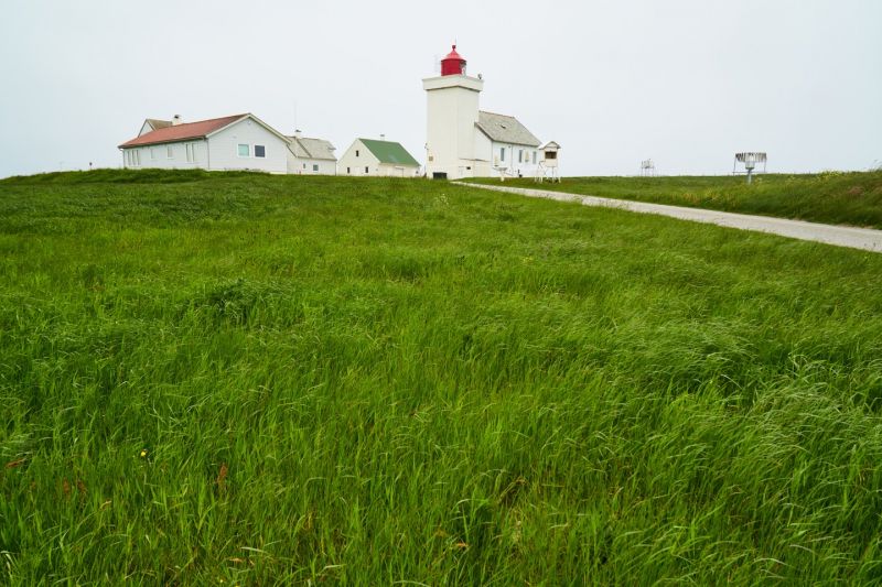
Kvassheim fyr
The lighthouse was built in 1912 to guide shipping along the Jæren coast. It has not been in operation since 1990 and has been converted into a museum and café. We spend our lunch break here and are surrounded by grazing cows while looking out over the sea.
4363 Brusand, Norwegen
58° 32' 38.4" N 5° 40' 54.2" E
58.5440111 5.6817315
• Head northwest on Kvassheim. Go for 48 m.
• Turn slightly right onto Kvassheim. Go for 599 m.
• Turn left onto Nordsjøvegen (44). Go for 12.9 km.
• Turn left onto Håvegen. Go for 1.3 km.
• Turn left onto Håvegen (4370). Go for 1.4 km.
• Turn left onto Håvegen. Go for 339 m.
• Arrive at Håvegen. Your destination is on the right.
☍
16,6 km
( 16 min.)
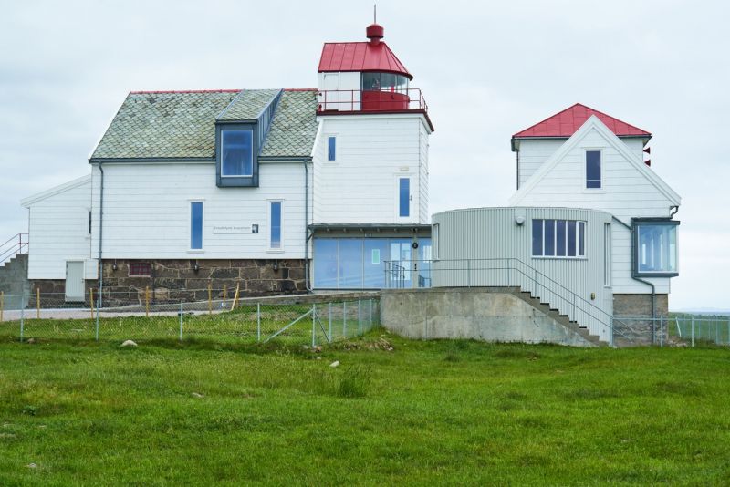
Obrestad fyr
There are several preserved lighthouses along the Jæren coast, this one dates from 1873 and houses an exhibition on the lighthouse keepers during the Second World War. During our visit the buildings are mostly deserted, after a short walk we continue to Stavanger.
Håvegen 282, 4365 Nærbø, Norwegen
58° 39' 32" N 5° 33' 17.7" E
58.6588803 5.5549112
• Head northeast on Håvegen. Go for 339 m.
• Turn right onto Håvegen (4370). Go for 1.4 km.
• Turn slightly left onto Vigre (4370). Go for 1.3 km.
• Turn left onto Nordsjøvegen (44). Go for 2.1 km.
• Turn left onto 507. Go for 8.9 km.
• Turn left onto Nordsjøvegen. Go for 286 m.
• Turn right. Go for 104 m.
• Turn left. Go for 30 m.
• Arrive at your destination.
☍
14,6 km
( 17 min.)
Orrestranda & Friluftshuset Orre
The Orrestranda with a length of 5 km is one of the most beautiful beaches in Norway. During our detour we watch two kitesurfers in the rough sea, the wind is also picking up out here.
Orrestranda, Klepp, Norwegen
58° 44' 23.5" N 5° 30' 45.5" E
58.7398570 5.5126318
• Head southeast. Go for 30 m.
• Turn right toward Nordsjøvegen. Go for 37 m.
• Turn right onto Nordsjøvegen. Go for 373 m.
• Turn left onto Nordsjøvegen (507). Go for 9.0 km.
• Turn left onto Solavegen (510). Go for 1.1 km.
• Turn right onto Vollvegen (4476). Go for 776 m.
• Continue on Sveinsvollvegen (4476). Go for 2.5 km.
• Continue on 4476. Go for 32 m.
• Continue on Heigreveien (4476). Go for 5.2 km.
• Take the 3rd exit from roundabout onto 444. Go for 1.8 km.
• Take the 2nd exit from roundabout onto 444. Go for 334 m.
• Take ramp onto E39 toward Stavanger. Go for 11.2 km.
• Take the exit. Go for 237 m.
• Pass 3 roundabouts and continue on Motorveien. Go for 926 m.
• Take the 1st exit from roundabout onto Madlaveien (441) toward Sentrum/Ferje/13/Ferge Gb Dk/Turistinformasjon. Go for 104 m.
• Turn right onto Tjodolvs gate. Go for 48 m.
• Turn right onto Tjodolvs gate. Go for 167 m.
• Turn slightly right onto Tjodolvs gate. Go for 112 m.
• Arrive at Tjodolvs gate.
☍
34,0 km
( 33 min.)
Stellplatz in Stavanger
Tjodolvs gate, Stavanger, Norwegen
58° 57' 38" N 5° 43' 24.7" E
58.9605457 5.7235208
• Head southwest on Tjodolvs gate.
• Arrive at Tjodolvs gate.
☍
Distance not available
(Duration not available)
Day
Ausgezeichnete Altstadt
Our first destination in Norway is Stavanger. After the natural scenery of the Flekkefjord follows Norway's fourth largest city with the seaport, where the M/S Astor is just leaving us. We stay here for two nights and visit the Norsk Oil Museum at the harbor tomorrow.
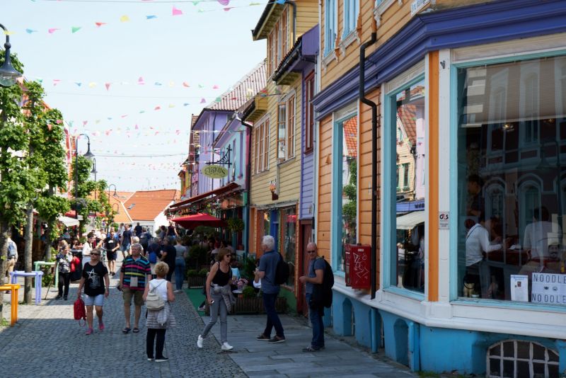
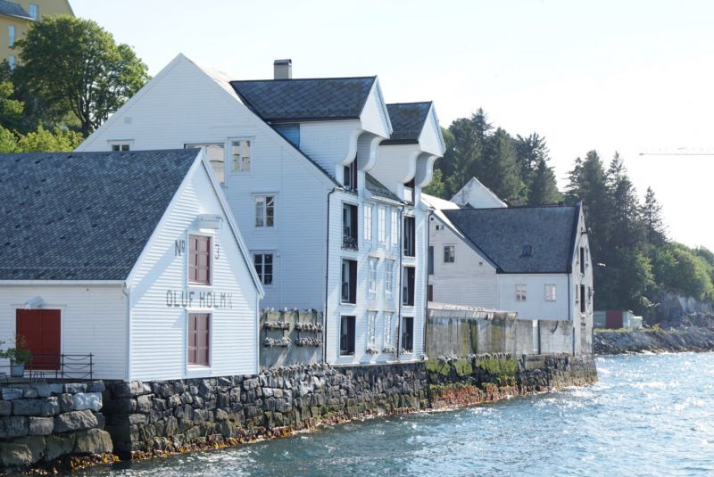
Gamle Stavanger, the old town, has received several awards, as the more than 170 colorful wooden houses from the 18th century were restored as part of an architectural program and thus characterize the appearance of the old town to this day. Norway's Oil Museum is also located here at the port.
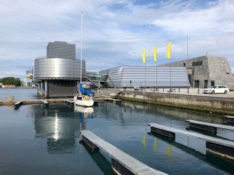
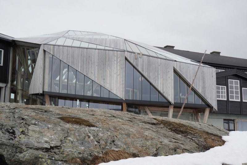
Norsk Oljemuseum
The exhibition at the Stavanger Petroleum Museum focuses on offshore production in the North Sea. The exterior architecture in particular is reminiscent of an oil drilling platform or an offshore structure.
Stellplatz in Stavanger
Tjodolvs gate, Stavanger, Norwegen
58° 57' 38" N 5° 43' 24.7" E
58.9605457 5.7235208
• Head toward Johan Thorsens gate on Tjodolvs gate. Go for 279 m.
• Turn right onto Peder Klows gate. Go for 97 m.
• Turn left onto Wessels gate. Go for 63 m.
• Turn right onto Madlaveien (441). Go for 207 m.
• Take the 3rd exit from roundabout onto Madlaveien (441). Go for 458 m.
• Take the 2nd exit from roundabout onto Motorveien toward 510/Kristiansand/Sandnes/Lufthavn Sola. Go for 197 m.
• Take the 2nd exit from roundabout onto Motorveien. Go for 275 m.
• Take the 2nd exit from roundabout onto Hundvågtunnelen (13). Go for 6.3 km.
• Take the 1st exit from roundabout onto Ryfylketunnelen (13). Go for 14.9 km.
• Take the 2nd exit from roundabout onto Ryfylkevegen (13). Go for 1.3 km.
• Turn right onto Kyrkjebakken (4650). Go for 855 m.
• Continue on Kyrkjebakken (4652). Go for 14 m.
• Continue on Monanevegen (4652). Go for 79 m.
• Turn right onto Tjøstheimsvegen (4654). Go for 2.5 km.
• Turn left onto Tjøstheimsvegen (4654). Go for 3.8 km.
• Turn right onto Ryfylkevegen (13). Go for 37.5 km.
• Take the 2nd exit from roundabout onto 13. Go for 269 m.
• Take the Hjelmeland-Nesvik Ferry. Stay on for 3.1 km.
• Head toward Jøsnesvegen on Indre Ryfylkevegen (13). Go for 30.5 km.
• Turn left onto Indre Ryfylkevegen (517) toward Haugesund/46/Sauda/520/Jelsa. Go for 3.5 km.
• Continue on 46. Go for 3.0 km.
• Arrive at Indre Ryfylkevegen (46). Your destination is on the right.
☍
109,1 km
(2 hrs. 15 min.)
Day
Ostasteidn
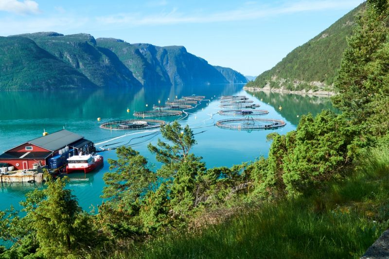
We stop after Sandsfjord Bridge on the west side of Sandsfjord to have a snack at this rest area. On the way to the fjord we see an aquaculture farm from a hill.
Suldal, Norwegen
59° 24' 48.4" N 6° 7' 0.6" E
59.4134338 6.1168306
• Head south on Indre Ryfylkevegen (46). Go for 3.0 km.
• Continue on Indre Ryfylkevegen (517). Go for 3.5 km.
• Turn left onto Sandsvegen (13). Go for 10.7 km.
• Turn right onto Suldalsvegen (13). Go for 67.3 km.
• Turn right onto Håra (E134). Go for 3.3 km.
• Turn right onto Kyrkjevegen. Go for 534 m.
• Arrive at Kyrkjevegen. Your destination is on the right.
☍
88,3 km
(1 hrs. 26 min.)
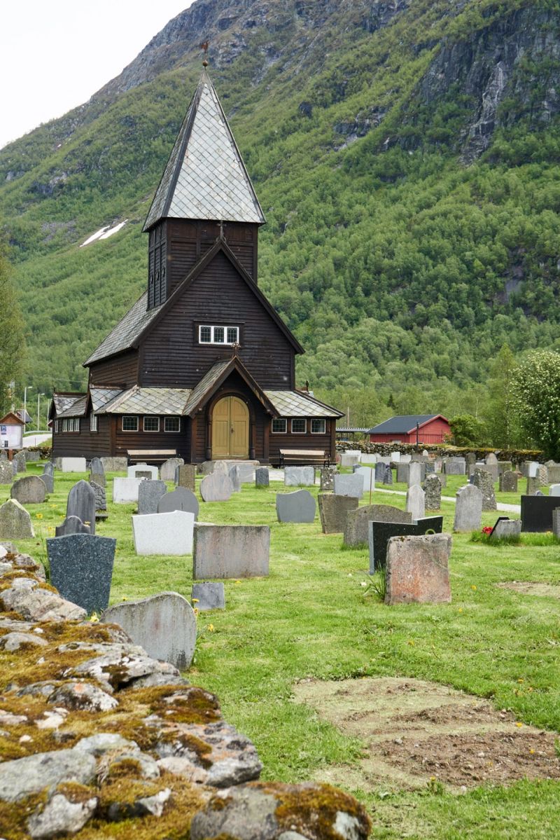
Stavkirken Røldal
The stave church in Røldal has existed since 1250 and is said to house a crucifix in the interior that is said to have healing powers. The 50 NOK entrance fee per person seems too much to us, so we walk around and enjoy the midsummer weather.
Kyrkjevegen 34, 5760 Røldal, Norwegen
59° 49' 51.1" N 6° 49' 21.6" E
59.8308531 6.8226549
• Head west on Kyrkjevegen. Go for 534 m.
• Turn left onto Haukelivegen (E134). Go for 23.3 km.
• Turn right onto 13 toward Brimnes/Odda/550/Utne/551/48/Rosendal. Go for 3.4 km.
• Arrive at 13. Your destination is on the right.
☍
27,2 km
( 27 min.)
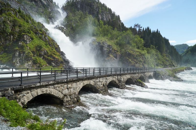
Låtefossen
The twin waterfalls drain snowmelt from Folgefonna, one of Norway's largest mainland glaciers. The long-distance road leads directly past the imposing natural spectacle.
Låtefossen, Odda, Norwegen
59° 56' 51.3" N 6° 35' 5.6" E
59.9475905 6.5848765
• Head north on 13. Go for 14.1 km.
• Turn right onto Smelteverket. Go for 261 m.
• Turn right onto Smelteverket. Go for 57 m.
• Turn slightly left toward Tyssedalsvegen. Go for 193 m.
• Continue on Tyssedalsvegen. Go for 343 m.
• Arrive at Tyssedalsvegen. Your destination is on the right.
☍
15,0 km
( 15 min.)
Odda Bobilcamp
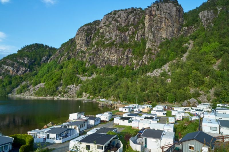
We set up our overnight quarters at the Sørfjord in Odda. We look at the Folgefonna glacier across from the fjord while sunbathing. In the evening there are calzones from the Omnia, which attracts our neighbors. Sunset easily passes 11pm, keeping us awake and warm.
Almerket, 5750 Odda, Norwegen
60° 4' 18" N 6° 32' 54.7" E
60.0716683 6.5485224
• Head south on Tyssedalsvegen. Go for 343 m.
• Turn right onto Røldalsvegen. Go for 239 m.
• Turn right onto Røldalsvegen. Go for 48 m.
• Turn right onto Kremarvegen (13). Go for 6.1 km.
• Turn left onto Gamle Oddaveg. Go for 23 m.
• Turn right onto Naustbakken. Go for 327 m.
• Turn right onto Naustbakken. Go for 20 m.
• Arrive at Naustbakken. Your destination is on the left.
☍
7,1 km
( 9 min.)
Day
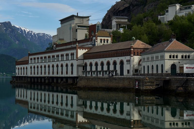
Norwegisches Wasserkraft- und Industriemuseum Tyssedal
The former hydroelectric power station in Tyssedal now houses an exhibition on the early years of industrialization in Norway. The spot is ideal for taking photos in the morning and is also suitable as a parking space for an overnight stay.
Naustbakken 7, 5770 Tyssedal, Norwegen
60° 7' 9.1" N 6° 33' 22.4" E
60.1192072 6.5562201
• Head south on Naustbakken. Go for 20 m.
• Turn left onto Naustbakken. Go for 327 m.
• Turn left onto Gamle Oddaveg. Go for 23 m.
• Turn right onto Stanavegen (13). Go for 5.9 km.
• Turn right onto Eitrheimsvegen. Go for 185 m.
• Turn right onto Eitrheimsvegen. Go for 216 m.
• Take the 1st exit from roundabout onto Eitrheimsvegen (49). Go for 2.7 km.
• Take the 2nd exit from roundabout onto 49. Go for 12.5 km.
• Turn right onto 49. Go for 62 m.
• Continue on Austrepollen (49). Go for 146 m.
• Continue on 49. Go for 292 m.
• Continue on Kamrygg (49). Go for 110 m.
• Continue on 49. Go for 4.8 km.
• Continue on Nordrepollen (49). Go for 122 m.
• Continue on 49. Go for 474 m.
• Continue on Jondalstunnelen (49). Go for 10.1 km.
• Continue on 49. Go for 584 m.
• Continue on Torsnestunnelen (49). Go for 605 m.
• Continue on 49. Go for 386 m.
• Take the 1st exit from roundabout onto Belsnesvegen (49). Go for 5.4 km.
• Continue on Jonavegen (550). Go for 10.2 km.
• Arrive at Herandsvegen (550). Your destination is on the left.
☍
55,2 km
( 56 min.)
Hereiane
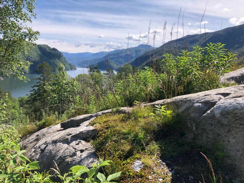
Today's lunch break is on a peninsula in the Hardangerfjord. The wooded shore draws our gaze to the steep rocky outcrops above us.
Fv550, 5628 Herand, Norwegen
60° 19' 42.4" N 6° 20' 17.4" E
60.3284428 6.3381618
• Head south on Herandsvegen (550). Go for 10.2 km.
• Turn right onto 49. Go for 98 m.
• Take the Jondal-Trøvikbygd Ferry. Stay on for 5.2 km.
• Head toward Skutevik on Tørvikbygdvegen (49). Go for 191 m.
• Turn right onto Tørvikbygdvegen (49). Go for 12.7 km.
• Turn left onto Steinsdalsvegen (49). Go for 69 m.
• Take the 1st exit from roundabout onto Steinsdalsvegen (49). Go for 2.0 km.
• Turn right onto Steinsdalsvegen. Go for 179 m.
• Arrive at Steinsdalsvegen. Your destination is on the left.
☍
30,6 km
(1 hrs. 6 min.)
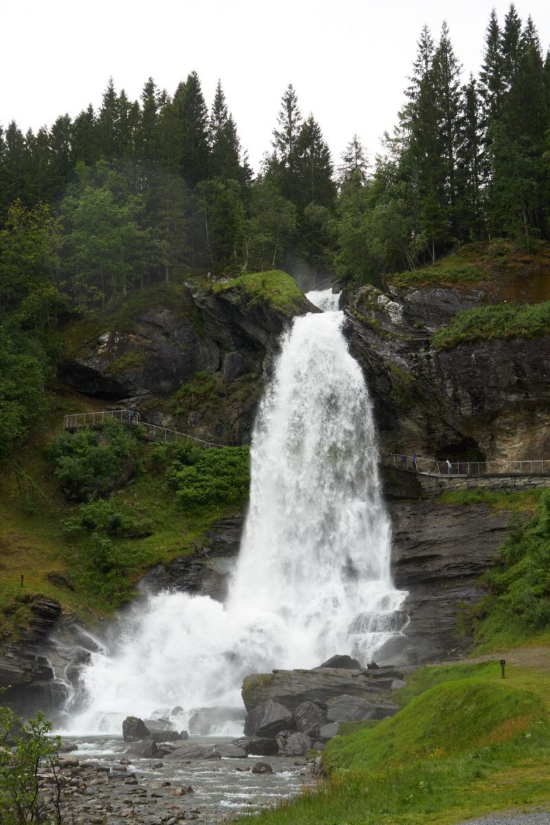
Steinsdalsfossen
Journey behind the falls in Norwegian. Its special feature is a path between the rock face and the water, on which you can walk almost dry behind Steinsdalsfossen. The weather is different for us and we get wet anyway.
Steinsdalsvegen 212, 5600 Norheimsund, Norwegen
60° 22' 12.8" N 6° 6' 28.9" E
60.3702147 6.1080313
• Head east on Steinsdalsvegen. Go for 57 m.
• Turn right onto Steinsdalsvegen. Go for 27 m.
• Turn left onto Steinsdalsvegen (49). Go for 2.0 km.
• Take the 2nd exit from roundabout onto Steinsdalsvegen (49). Go for 103 m.
• Continue on Hardangerfjordvegen (79). Go for 4.9 km.
• Take the 3rd exit from roundabout onto Hardangerfjordvegen (7). Go for 793 m.
• Take the 2nd exit from roundabout onto Hardangerfjordvegen (79). Go for 44.6 km.
• Turn right onto 13 toward Oslo/7/Odda/Ulvik/572. Go for 7.1 km.
• Take the 1st exit from roundabout onto Vallaviktunnelen (13). Go for 3.3 km.
• Take the 1st exit from Butunnelen roundabout onto Eidfjordvegen (7). Go for 10.7 km.
• Arrive at Eidfjordvegen (7).
☍
73,5 km
(1 hrs. 11 min.)
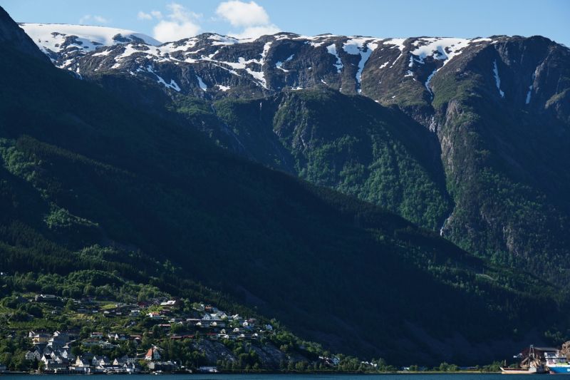
Eidfjord
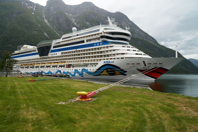
We have arrived at the Eidfjord and spend the night at the pier opposite the M/S AIDASol, which is still moored. Hardanger, Norway's orchard, was our destination today and it was as changeable as the weather.
Eidfjorden, Eidfjord kommune, Norwegen
60° 29' 15.5" N 7° 0' 36.8" E
60.4876299 7.0102308
• Head east on Eidfjordvegen (7). Go for 21.6 km.
• Turn left. Go for 23 m.
• Turn right. Go for 99 m.
• Turn left. Go for 209 m.
• Arrive at your destination on the left.
☍
21,9 km
( 20 min.)
Day
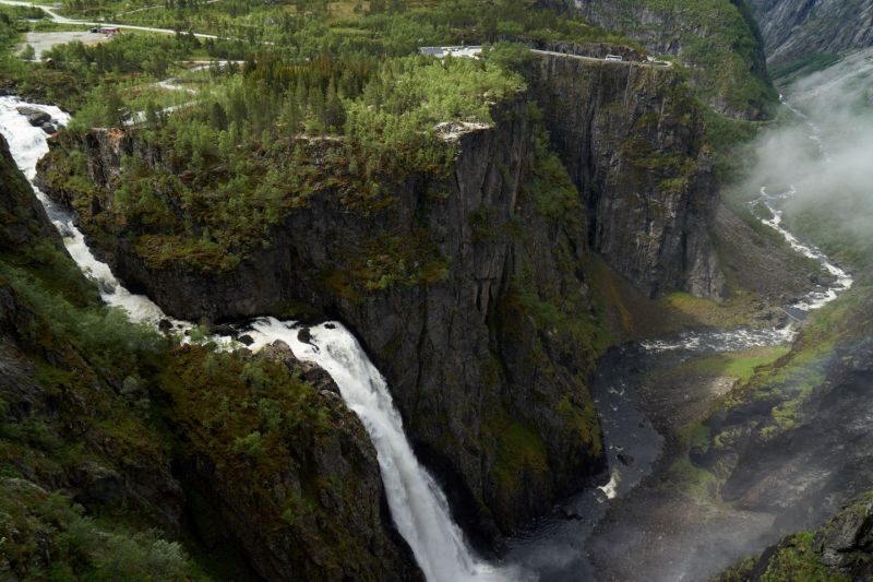
Vøringsfossen
Norway's most important waterfall is in Eidfjord and in the middle of the Hardangervidda. We walk at the Fossatromma car park on the edge of the ridge overlooking the famous Fossli Hotel. Then we drive up to the vantage point at the hotel and marvel at the sight of the water masses falling steeply into the gorge.
Eidfjord, Norwegen
60° 25' 35.7" N 7° 15' 5.3" E
60.4265721 7.2514658
• Head west. Go for 209 m.
• Turn right. Go for 99 m.
• Turn left toward Hardangervidda/7. Go for 23 m.
• Turn left onto Hardangervidda (7). Go for 73.2 km.
• Arrive at Ustedalen (7). Your destination is on the left.
☍
73,6 km
(1 hrs. 3 min.)
Geilo
Stopover on the way over Hardangerviddavegn, past snowfields, into Aurlandsfjellet. It's bitterly cold outside. Geilo seems dead, the ski tourists have already flown out at the end of the season.
Geilo, Norwegen
60° 32' 1.1" N 8° 12' 31.7" E
60.5336513 8.2087948
• Head east on Ustedalen (7). Go for 6 m.
• Take the 2nd exit from roundabout onto Lienvegen (7). Go for 11.0 km.
• Turn left onto Holsfjordvegen (50) toward Aurland/Hovet/Hol sentrum. Go for 33.4 km.
• Turn left onto Strønde. Go for 81 m.
• Arrive at Strønde.
☍
44,5 km
( 38 min.)
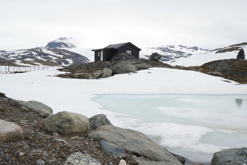
Hallingskarvet NP
At the end of Måbødalen we continue towards Haugastøl and cross Europe's largest plateau with the Hardangervidda. We stay overnight at the Strandavatnet reservoir in Hallingskarvet National Park.
Strandavatnet, Hol, Norwegen
60° 41' 31.2" N 7° 51' 7.8" E
60.6920092 7.8521699
• Head north on Strønde. Go for 81 m.
• Turn left onto Strønde (50). Go for 60.6 km.
• Take the 2nd exit from roundabout. Go for 72 m.
• Continue on Skulevegen (5627). Go for 1.1 km.
• Turn right onto Bakkane. Go for 399 m.
• Arrive at Bakkane. Your destination is on the right.
☍
62,3 km
( 54 min.)
Day
Aurlandsfjord
After a spectacular descent over tunneled mountain passes, we have arrived at the Aurlandsfjord. The weather is a piñata, just like the sometimes bizarre landscape. The mountains are surrounded by fast-moving clouds, resulting in a different motif depending on the time.
Aurland, Norwegen
60° 54' 24.6" N 7° 11' 25.9" E
60.9068343 7.1905349
• Head north on Bakkane. Go for 326 m.
• Turn right onto Bjørgavegen (5627). Go for 1.4 km.
• Continue on Kvam (5627). Go for 96 m.
• Continue on Bjørgavegen (5627). Go for 6.2 km.
• Arrive at Bjørgavegen (5627). Your destination is on the right.
☍
8,0 km
( 13 min.)
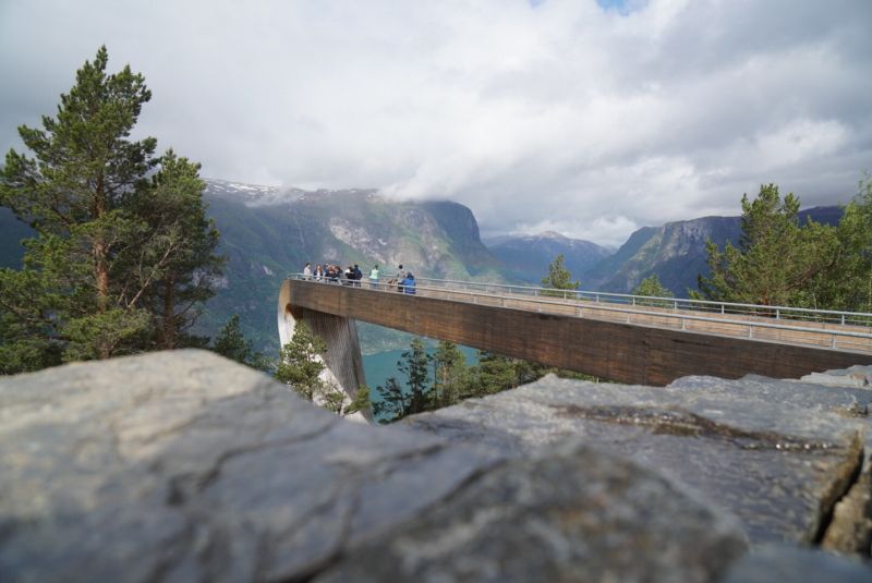
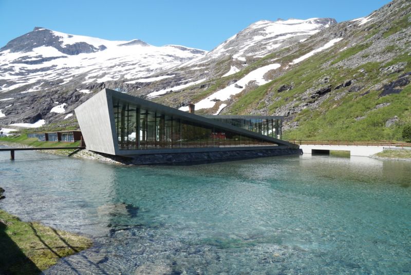
Stegastein
Stegastein is a stunning viewing platform 650m high and 30m above the mountain ledge by the Aurlandsfjord. The viewpoint is also part of the Norwegian Tourist Route running from Aurland to Lærdal, commonly known as 'the Snow Road'. Here we "experience" a spectacular view of the Aurlandsfjord on our way to Aurlandsfjellet.
Stegastein- LOOKOUT, Aurland, Norwegen
60° 54' 29.8" N 7° 12' 45.1" E
60.9082803 7.2125244
• Head northwest on Bjørgavegen (5627). Go for 6.2 km.
• Continue on Kvam (5627). Go for 96 m.
• Continue on Bjørgavegen (5627). Go for 1.7 km.
• Turn right onto Bjørgavegen (5627). Go for 7 m.
• Continue on Vangen (5627). Go for 93 m.
• Continue on Bjørgavegen (5627). Go for 20 m.
• Continue on Vangen (5627). Go for 26 m.
• Continue on Bjørgavegen (5627). Go for 14 m.
• Turn left onto Vangen (5627). Go for 69 m.
• Continue on Skulevegen (5627). Go for 1.6 km.
• Take the 3rd exit from roundabout onto E16 toward Oslo/Lærdal. Go for 25.1 km.
• Take the 2nd exit from roundabout onto 5 toward Sogndal/Lærdal. Go for 6.8 km.
• Take the 2nd exit from roundabout onto Habnavegen. Go for 531 m.
• Turn left onto 5627. Go for 2.7 km.
• Turn left onto Sanden (5627). Go for 2.2 km.
• Continue on Erdalsvegen (5627). Go for 6.1 km.
• Arrive at Erdalsvegen (5627).
☍
53,3 km
( 56 min.)
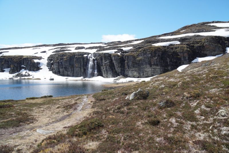
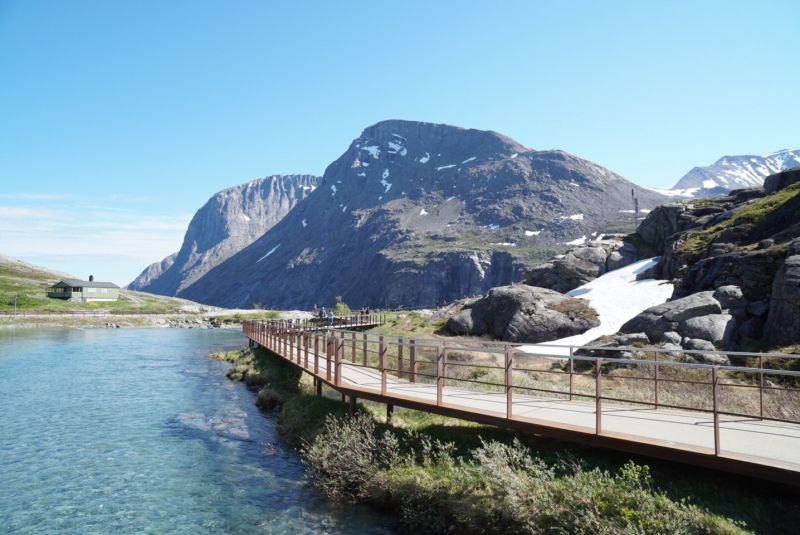
Aurlandsfjellet
Incredibly beautiful hike at over 1,200m to one of Norway's most beautiful waterfalls, after we drove up from the Aurlandsfjord into the unreal snow and rock landscape of the Aurlandsfjellet.
Aurlandsfjellet, Lærdal Municipality, Norwegen
61° 3' 0" N 7° 20' 24" E
61.0500000 7.3400000
• Head north on Erdalsvegen (5627). Go for 8.3 km.
• Turn right onto 5627. Go for 2.8 km.
• Continue on Habnavegen. Go for 417 m.
• Take the 1st exit from roundabout onto 5. Go for 6.8 km.
• Take the 2nd exit from roundabout onto E16 toward Oslo/Fagernes. Go for 19.3 km.
• Turn left onto 630 toward Husum. Go for 171 m.
• Continue on Liheim (630). Go for 104 m.
• Continue on 630. Go for 730 m.
• Continue on Vetlestølen (630). Go for 150 m.
• Continue on 630. Go for 524 m.
• Turn right toward Vindhella. Go for 19 m.
• Turn left onto Vindhella. Go for 66 m.
• Arrive at Vindhella. Your destination is on the right.
☍
39,4 km
( 39 min.)
Borgund Stavkyrkje
Borgund Stave Church is the most important example of Norwegian stave churches and one of the oldest wooden buildings in Europe. She is our final destination for today. We are the last visitors in the evening and will spend the night opposite the church on a wild river.
Vindoella 621, 6888 Borgund, Norwegen
61° 2' 50.6" N 7° 48' 44.6" E
61.0473886 7.8123842
• Head south on Vindhella. Go for 72 m.
• Turn left onto 630. Go for 653 m.
• Continue on Vetlestølen (630). Go for 150 m.
• Continue on 630. Go for 730 m.
• Continue on Liheim (630). Go for 104 m.
• Continue on 630. Go for 171 m.
• Turn right onto E16. Go for 19.3 km.
• Take the 1st exit from roundabout onto 5 toward Sogndal/Lærdal. Go for 6.8 km.
• Take the 1st exit from roundabout onto Fodnesvegen (5) toward Sogndal/Årdal. Go for 208 m.
• Take the 2nd exit from roundabout onto Grandavegen (5) toward Sogndal/Årdal. Go for 8.5 km.
• Keep left onto 5. Go for 366 m.
• Take the Fodnes-Mannheller Ferry. Stay on for 3.1 km.
• Head north on 5. Go for 16.5 km.
• Take the 1st exit from roundabout onto 55 toward Lom/Gaupne. Go for 27.5 km.
• Turn left onto Jostedalsvegen (604) toward Jostedalen. Go for 15.7 km.
• Continue on Jostedalsvegen (604). Go for 133 m.
• Continue on Jostedalsvegen (604). Go for 462 m.
• Continue on Jostedalsvegen (604). Go for 148 m.
• Continue on Jostedalsvegen (604). Go for 14.0 km.
• Turn right onto Jostedalsvegen. Go for 167 m.
• Arrive at Jostedalsvegen. Your destination is on the right.
☍
114,7 km
(2 hrs. 26 min.)
Day
Wanderung auf dem Vindhellavegen durch das historische Lærdal
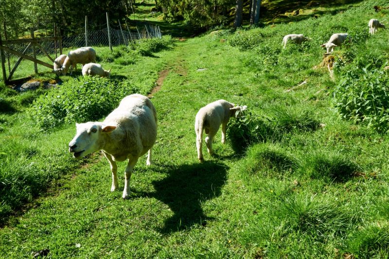
Early morning walk on the Vindhellavegen, an old trade route which partly picks up the Kongevegen, near Borgund Stave Church. Apart from the grumpy bleating of a flock of sheep, nobody disturbs this mystical place.
Wanderung am Jostedalsbreen-Gletscher
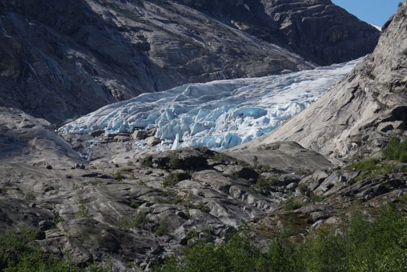
Nigardsbreen is a glacial tongue of the Jostedalsbreen, Europe's largest mainland glacier, whose glacial snout and surrounding glacial cut landscape are very impressive. On our hike, we'll take the boat out to climb the smooth granite and capture a shot of the perennial blue or the "whisper of the age" glacial ice. We spend the night in Jostedal at the local campsite.
Jostedal Camping
Gjerde, 6871, Jostedal, Norwegen
61° 37' 49.1" N 7° 15' 58" E
61.6303000 7.2661000
• Head west on Jostedalsvegen. Go for 167 m.
• Turn left onto Jostedalsvegen (604). Go for 14.0 km.
• Continue on Jostedalsvegen (604). Go for 148 m.
• Continue on Jostedalsvegen (604). Go for 462 m.
• Continue on Jostedalsvegen (604). Go for 133 m.
• Continue on Jostedalsvegen (604). Go for 15.7 km.
• Turn right onto Lustravegen (55). Go for 27.5 km.
• Take the 1st exit from roundabout onto 5 toward Førde/55/Vadheim. Go for 629 m.
• Pass 2 roundabouts and continue on Gravensteinsgata (5). Go for 705 m.
• Take the 1st exit from roundabout onto 5 toward Førde/Skei. Go for 61.0 km.
• Take the 1st exit from roundabout onto Jølstravegen (E39) toward Ålesund/Nordfjordeid. Go for 19.9 km.
• Turn right onto Fjellvegen (60) toward Stryn. Go for 57.4 km.
• Take the 1st exit from roundabout onto Tonningsgata (15). Go for 90.7 km.
• Turn right. Go for 35 m.
• Arrive at your destination on the left.
☍
288,4 km
(4 hrs. 20 min.)
Day
Sognefjellet
We have arrived at over 1,400m and drive through the ice and snowy landscape of Sognefjellet. Out here we stand alone in the middle of this unreal landscape, hike to vantage points from which we catch views of the surrounding peaks and cook something delicious for lunch at Omnia. We then continue on our route north and pass Sognefjellshytta, where we make another stop. The temperature is still 4 degrees and the sky is once again darkening at an alarming rate.
Heggjebottvatnet
We spend the night at Heggjebottvatnet at a rest area, overlooking the tranquil lake and surrounding mountains, enjoying the tranquility away from the tourist crowds.
50, Rv15, 2693 Nordberg, Norwegen
61° 56' 25.5" N 8° 1' 20" E
61.9404128 8.0222126
• Head east. Go for 35 m.
• Turn left onto 15. Go for 39.5 km.
• Turn right onto 63 toward Geiranger. Go for 7.4 km.
• Turn right toward Nibbevegen. Go for 88 m.
• Continue on Nibbevegen. Go for 4.6 km.
• Arrive at Nibbevegen. Your destination is on the right.
☍
51,5 km
( 47 min.)
Day
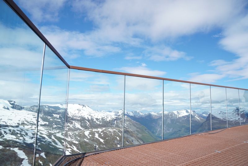
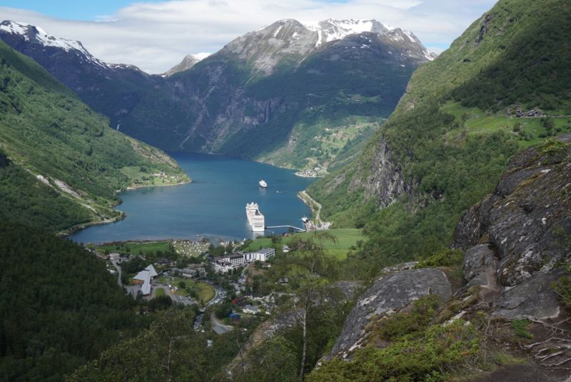
Geiranger Skywalk
After spending the night at Heggjebottvatnet, we drove over steep mountain passes to the Dalsnibba viewpoint at over 1,400m in the morning to enjoy the view of the Geirangerfjord in bright sunshine.
6216 Geiranger, Norwegen
62° 2' 56.4" N 7° 16' 12.5" E
62.0489958 7.2701410
• Head east on Nibbevegen. Go for 4.7 km.
• Turn left onto Geirangervegen (63). Go for 7.4 km.
• Turn right onto 15. Go for 51.2 km.
• Take the 1st exit from roundabout onto Nordfjordvegen (15) toward 60/Stranda. Go for 15.8 km.
• Turn right onto E39 toward Ålesund/Volda/Grodås. Go for 8.3 km.
• Turn right onto Hornindalsvegen (60) toward Sykkylven/Stranda/Hellesylt. Go for 25.0 km.
• Turn right onto Hellesyltvegen (60) toward Hellesylt/Ferge Geiranger. Go for 878 m.
• Turn left onto Hellesyltvegen (60). Go for 578 m.
• Take the Hellesylt-Geiranger Ferry. Stay on for 20.1 km.
• Head toward Ørnevegen on 63. Go for 119 m.
• Turn left onto Ørnevegen (63). Go for 1.8 km.
• Turn left. Go for 237 m.
• Arrive at your destination on the right.
☍
136,1 km
(2 hrs. 56 min.)
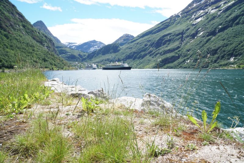
Geirangerfjorden Feriesenter
We have moved into our quarters at the Geirangerfjord and are enjoying a short break from our road trip. The weather is getting better and better towards the weekend. We rent a boat from the campsite and drive to the Seven Sisters, a 300m high waterfall about 30 minutes away. In the evening we made reservations for dinner at the adjoining Grande Fjord Hotel. The cruise ships and ships of the Hurtigruten fleet pass us while sunbathing.
6216, Geiranger, Norwegen
62° 6' 53.3" N 7° 11' 5.3" E
62.1148000 7.1848000
• Head west.
• Arrive at your destination on the right.
☍
Distance not available
(Duration not available)
Day
Bootsfahrt auf dem Geirangerfjord
During a boat trip on the Geirangerfjord, we pass the seven waterfalls that fall side by side, the Seven Sisters , which lead the snowmelt from a height of around 250 m into the fjord. According to a legend that has been handed down, all seven sisters rejected the courtship of a suitor and remained unmarried. The waterfall opposite is called Freier . The view from our boat is breathtaking.
Geirangerfjorden Feriesenter
6216, Geiranger, Norwegen
62° 6' 53.3" N 7° 11' 5.3" E
62.1148000 7.1848000
• Head east. Go for 237 m.
• Turn left onto Ørnevegen (63). Go for 6.2 km.
• Turn left onto Indreeidstunnelen (63) toward Åndalsnes/Eidsdal. Go for 5.2 km.
• Turn left onto 63 toward Åndalsnes/Eidsdal. Go for 11.8 km.
• Take the Eidsdal-Linge Ferry. Stay on for 2.6 km.
• Head toward Lingestranda on 63. Go for 156 m.
• Turn right onto Lingestranda (63). Go for 4.3 km.
• Turn left onto 63. Go for 35.1 km.
• Arrive at Isterdalsvegen (63). Your destination is on the right.
☍
65,6 km
(1 hrs. 42 min.)
Day
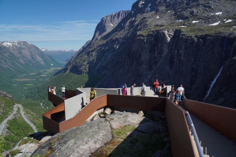
Trollstigen
The famous mountain road with its 11 hairpin bends impresses with its breathtaking views and is one of the most visited tourist attractions in Norway. We rode the troll ladder twice today, namely down, because we also used the ride up to visit the viewing platform.
Trollstigen, Rauma, Norwegen
62° 27' 17.7" N 7° 39' 57.5" E
62.4549066 7.6659830
• Head southwest on Isterdalsvegen (63). Go for 35.1 km.
• Turn right onto 63. Go for 4.3 km.
• Continue on Lingestranda (650). Go for 40.2 km.
• Turn left onto Ålesundsvegen (E39/E136). Go for 29.1 km.
• Take the 1st exit from roundabout toward Breivika. Go for 207 m.
• Take the 2nd exit from roundabout onto Lerstadvegen (534). Go for 2.8 km.
• Take the 2nd exit from roundabout onto E136. Go for 227 m.
• Continue on E136. Go for 258 m.
• Turn right onto E136. Go for 16 m.
• Turn right onto E136. Go for 2.1 km.
• Continue on Skuggetunnelen (E136). Go for 189 m.
• Continue on E136. Go for 136 m.
• Continue on Nørvasund bru (E136). Go for 85 m.
• Continue on E136. Go for 4.4 km.
• Continue on Sjøgata (E136). Go for 210 m.
• Continue on Korsegata. Go for 140 m.
• Continue on Skansegata. Go for 266 m.
• Turn right onto Skaregata. Go for 27 m.
• Turn left onto Kongens gate. Go for 129 m.
• Turn right onto Sorenskriver Bulls gate. Go for 57 m.
• Turn left. Go for 33 m.
• Arrive at your destination on the right.
☍
120,1 km
(1 hrs. 55 min.)
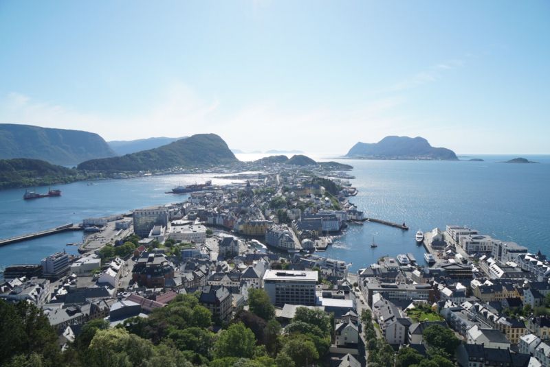
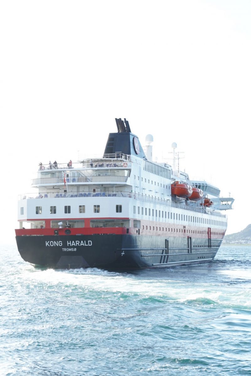
Bobilparkering Ålesund
After our trip on the Trollstigen we reach Ålesund in the early afternoon. We climb the 418 steps of the Aksla and enjoy the 360 degree panorama of the island metropolis in bright sunshine. On our way through the Art Nouveau city, we come across the M/S Kong Harald, which is just about to leave for its Hurtigrute.
Sorenskriver Bulls gate 33, 6002, Ålesund, Norwegen
62° 28' 34" N 6° 9' 26" E
62.4761111 6.1572222
• Head toward Sorenskriver Bulls gate. Go for 33 m.
• Turn right onto Sorenskriver Bulls gate. Go for 18 m.
• Turn left onto Storgata. Go for 191 m.
• Turn right onto Einarvikgata. Go for 111 m.
• Continue on Skansegata. Go for 199 m.
• Continue on Korsegata. Go for 140 m.
• Continue on Sjøgata (E136). Go for 210 m.
• Continue on E136. Go for 4.4 km.
• Continue on Nørvasund bru (E136). Go for 85 m.
• Continue on E136. Go for 136 m.
• Continue on Skuggetunnelen (E136). Go for 189 m.
• Continue on E136. Go for 2.1 km.
• Turn right onto E136. Go for 43 m.
• Turn right onto E136. Go for 258 m.
• Turn left onto E136. Go for 187 m.
• Take the 2nd exit from roundabout onto Lerstadvegen (534). Go for 2.8 km.
• Take the 1st exit from roundabout. Go for 205 m.
• Take the 3rd exit from roundabout onto E39/E136 toward Trondheim/Åndalsnes. Go for 52.8 km.
• Pass 2 roundabouts and continue on E39. Go for 2.9 km.
• Take the 1st exit from roundabout onto Furnesvegen (E39) toward Molde. Go for 2.5 km.
• Take the Vestnes-Molde Ferry. Stay on for 11.3 km.
• Head toward Fannestrandvegen on E39. Go for 786 m.
• Take the 1st exit from roundabout onto Fannefjordsvegen (E39) toward Trondheim/Kristiansund. Go for 3.2 km.
• Take the 2nd exit from roundabout onto Fannefjordsvegen (E39) toward Trondheim/Kristiansund/Eide. Go for 942 m.
• Take the 3rd exit from roundabout onto Årødalsvegen toward Eide/Einesvågen. Go for 2.0 km.
• Continue on 64. Go for 7.3 km.
• Pass 2 roundabouts and continue on Fræneidet (64). Go for 31.5 km.
• Turn right onto 64. Go for 4.4 km.
• Arrive at Atlanterhavsvegen (64). Your destination is on the right.
☍
131,0 km
(2 hrs. 34 min.)
Day
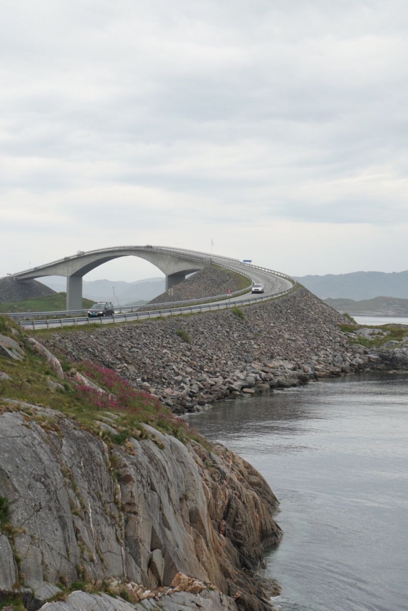
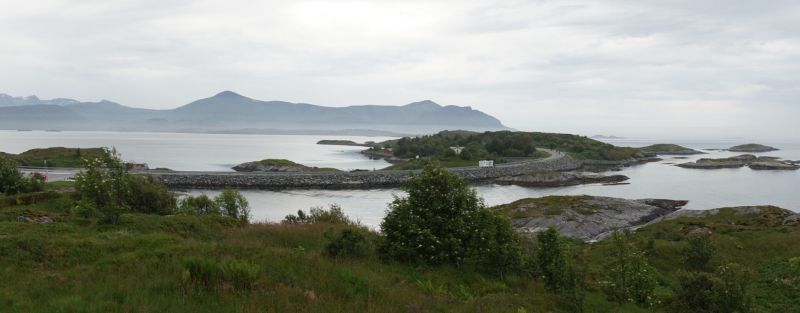
Atlanterhavsvegen
From Ålesund drive back and take the ferry to Molde. Today we have the last scenic route ahead of us and at the same time we reach our northernmost destination, the Atlantic Road. We cross the Storseisund Bridge several times, stopping every now and then to admire the spectacular architecture.
Fv64 10, 6530 Averøy, Norwegen
63° 1' 0.3" N 7° 21' 17.1" E
63.0167526 7.3547445
• Head west on Atlanterhavsvegen (64). Go for 4.4 km.
• Turn left onto Vevangvegen (64). Go for 15.2 km.
• Turn left onto 532. Go for 2.7 km.
• Continue on Strandvegen (532). Go for 98 m.
• Continue on 532. Go for 132 m.
• Continue on Strandvegen (532). Go for 261 m.
• Continue on 532. Go for 70 m.
• Continue on Strandvegen (532). Go for 536 m.
• Continue on 532. Go for 892 m.
• Continue on Strandvegen (532). Go for 799 m.
• Continue on 532. Go for 84 m.
• Continue on Strandvegen (532). Go for 359 m.
• Continue on 532. Go for 130 m.
• Continue on Strandvegen (532). Go for 20 m.
• Continue on 532. Go for 671 m.
• Continue on Strandvegen (532). Go for 459 m.
• Continue on 532. Go for 770 m.
• Continue on Strandvegen (532). Go for 357 m.
• Continue on 532. Go for 626 m.
• Continue on Strandvegen (532). Go for 115 m.
• Continue on 532. Go for 411 m.
• Continue on Strandvegen (532). Go for 802 m.
• Continue on 532. Go for 907 m.
• Continue on Røysan (532). Go for 12 m.
• Continue on 532. Go for 3.6 km.
• Continue on Kolset (532). Go for 96 m.
• Continue on 532. Go for 715 m.
• Continue on Storlandsvegen (532). Go for 2.9 km.
• Continue on 532. Go for 285 m.
• Continue on Grønset (532). Go for 88 m.
• Continue on 532. Go for 2.7 km.
• Turn left onto E39 toward Kristiansund. Go for 1.7 km.
• Take the 1st exit from roundabout onto Tingvollvegen (E39) toward 70/Trondheim/Sunndalsøra. Go for 13.1 km.
• Continue on Tingvollvegen (70) toward Sunndalsøra/Tingvoll. Go for 29.0 km.
• Turn right onto Rottåsvegen (6132). Go for 1.1 km.
• Turn slightly left onto Bergslia (6132). Go for 101 m.
• Turn slightly left onto Rottåsvegen (6132). Go for 2.4 km.
• Continue on 6132. Go for 238 m.
• Continue on Hjellen (6132). Go for 132 m.
• Continue on 6132. Go for 625 m.
• Continue on Fjøseidholtan (6132). Go for 98 m.
• Continue on Rottåsvegen (6132). Go for 640 m.
• Turn sharp left toward Fjøseid. Go for 364 m.
• Continue on Fjøseid. Go for 140 m.
• Turn left onto Fjøseid. Go for 684 m.
• Arrive at Fjøseid.
☍
91,6 km
(1 hrs. 22 min.)
Tingvollfjord
Today's pitch is on a wooded hill above the Tingvollfjord. Undisturbed by the parallel road and surrounded by tall trees, we are free tonight and will not travel further south until tomorrow.
Tingvollfjorden, Norwegen
62° 48' 4.9" N 8° 16' 16.9" E
62.8013711 8.2713581
• Head toward Rottåsvegen on Fjøseid. Go for 684 m.
• Turn right toward Fjøseid. Go for 62 m.
• Turn slightly left onto Fjøseid. Go for 442 m.
• Turn sharp right onto Rottåsvegen (6132). Go for 640 m.
• Continue on Fjøseidholtan (6132). Go for 98 m.
• Continue on 6132. Go for 625 m.
• Continue on Hjellen (6132). Go for 132 m.
• Continue on 6132. Go for 238 m.
• Continue on Rottåsvegen (6132). Go for 2.4 km.
• Turn slightly right onto Bergslia (6132). Go for 101 m.
• Turn slightly right onto Rottåsvegen (6132). Go for 1.1 km.
• Turn right onto Meisingsetvegen (70) toward Sunndalsøra. Go for 16.9 km.
• Turn right onto 70 toward Sunndalsøra. Go for 18.9 km.
• Pass 2 roundabouts and continue on 70. Go for 68.4 km.
• Take the 1st exit from roundabout onto Dovrevegen (E6) toward Oslo. Go for 328 m.
• Take the 2nd exit from roundabout onto E6 toward Oslo. Go for 47.4 km.
• Turn left onto Folldalsvegen (29) toward Folldal. Go for 28.6 km.
• Turn right onto 27. Go for 48.2 km.
• Turn right onto 27. Go for 32.8 km.
• Turn left onto Kjønnåsvegen (2578). Go for 3.7 km.
• Turn left onto Brugata (2576). Go for 549 m.
• Turn left onto Gudbrandsdalsvegen (E6). Go for 50.6 km.
• Take ramp toward Gausdal/Fåberg/Stor-Hove. Go for 264 m.
• Take the 3rd exit from roundabout onto 255. Go for 276 m.
• Take the 3rd exit from roundabout onto 2522. Go for 391 m.
• Take the 1st exit from roundabout onto 2522. Go for 583 m.
• Take the 1st exit from roundabout onto Gudbrandsdalsvegen (2522). Go for 814 m.
• Turn left onto Sigrid Undsets veg. Go for 2.5 km.
• Take the 2nd exit from roundabout onto Sigrid Undsets veg. Go for 615 m.
• Turn left onto Birkebeinervegen. Go for 1.1 km.
• Turn right onto Birkebeinervegen. Go for 140 m.
• Turn left onto Birkebeinervegen. Go for 159 m.
• Arrive at Birkebeinervegen. Your destination is on the left.
☍
329,8 km
(4 hrs. 30 min.)
Day
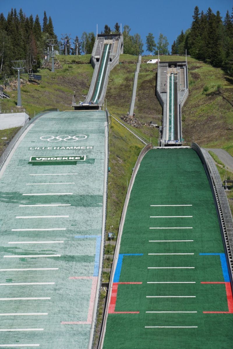
Lillehammer Olympiaparken
We have started the return journey and are making a stop in Lillehammer, staying the night at the 1994 Olympic ski jump. A group of young people is just jumping in, we hold our breath each time. The view of the small town is phenomenal and we sit with the best weather overlooking the lake.
Birkebeinervegen 124, 2618 Lillehammer, Norwegen
61° 7' 26.3" N 10° 29' 18.2" E
61.1239613 10.4883819
• Head southeast on Birkebeinervegen. Go for 159 m.
• Turn right onto Birkebeinervegen. Go for 140 m.
• Turn left onto Birkebeinervegen. Go for 535 m.
• Turn slightly left onto Birkebeinervegen. Go for 572 m.
• Turn left onto Sigrid Undsets veg. Go for 82 m.
• Continue on Maihaugvegen. Go for 403 m.
• Turn right onto Bankgata. Go for 460 m.
• Turn left onto Storgata. Go for 139 m.
• Turn right onto Langes gate. Go for 142 m.
• Turn right onto Kirkegata (213). Go for 186 m.
• Turn left onto Mesnadalsvegen. Go for 977 m.
• Take the 1st exit from roundabout onto E6 toward Oslo. Go for 5.3 km.
• Take the 2nd exit from roundabout onto E6. Go for 21.9 km.
• Take the 3rd exit from roundabout onto Mjøsbrua (E6) toward Oslo/Hamar. Go for 121 km.
• Continue on E6. Go for 27.5 km.
• Continue on 190 toward Sentrum/Kristiansand/E18. Go for 6.5 km.
• Take ramp toward DFDS/Stena/Sentralst. Go for 295 m.
• Turn right onto Rådhusgata toward Ring 1. Go for 106 m.
• Turn right onto Langkaia toward Akershus Slott. Go for 268 m.
• Continue on Akershusstranda toward E18/Stockholm/E6/Trondheim/Gøteborg/Akershus Slott. Go for 194 m.
• Take the 2nd exit from roundabout onto Akershusstranda toward Akershus Slott. Go for 255 m.
• Turn left onto Akershusstranda toward Vippetangen. Go for 73 m.
• Turn left onto Akershusstranda. Go for 96 m.
• Turn right onto Akershusstranda. Go for 133 m.
• Arrive at Akershusstranda. Your destination is on the left.
☍
187,2 km
(2 hrs. 4 min.)
Day
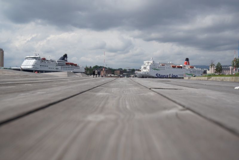
Stena Line Terminalen Oslo
Final sprint on our Fjord Norway road trip. We are at Oslo Ferry Terminal, exit 4 in Operaen Tunneln.
Akershusstranda 31, 0150 Oslo, Norwegen
59° 54' 10.1" N 10° 44' 36.3" E
59.9028097 10.7434226
• Head north on Akershusstranda. Go for 133 m.
• Turn left onto Akershusstranda. Go for 169 m.
• Turn right onto Akershusstranda toward E18/E6/Sentrum. Go for 220 m.
• Take the 1st exit from roundabout toward E18/Kristiansand/Ring 1. Go for 56 m.
• Continue on Akershusstranda. Go for 177 m.
• Continue toward E18/Kristiansand/Ring 1. Go for 85 m.
• Turn left onto Myntgata toward Kristiansand/E18. Go for 98 m.
• Turn right onto Skippergata toward E18/Kr.sand. Go for 169 m.
• Turn right onto Rådhusgata toward Kr.Sand/E18. Go for 50 m.
• Turn right toward Kristiansand. Go for 202 m.
• Take ramp onto Frognerstranda (E18). Go for 2.1 km.
• Keep left onto Frognerstranda (E18). Go for 156 km.
• Take the 1st exit from roundabout. Go for 235 m.
• Take ramp. Go for 179 m.
• Take the 2nd exit from roundabout onto E18. Go for 61.2 km.
• Take the 1st exit from roundabout onto E18. Go for 53.5 km.
• Take ramp toward Grimstad. Go for 231 m.
• Turn right onto Arendalsveien (420) toward Grimstad. Go for 1.3 km.
• Turn right onto Levermyrveien. Go for 42 m.
• Turn right onto Levermyrveien. Go for 158 m.
• Turn right onto Furuheia. Go for 105 m.
• Arrive at Furuheia. Your destination is on the right.
☍
276,0 km
(3 hrs. 3 min.)
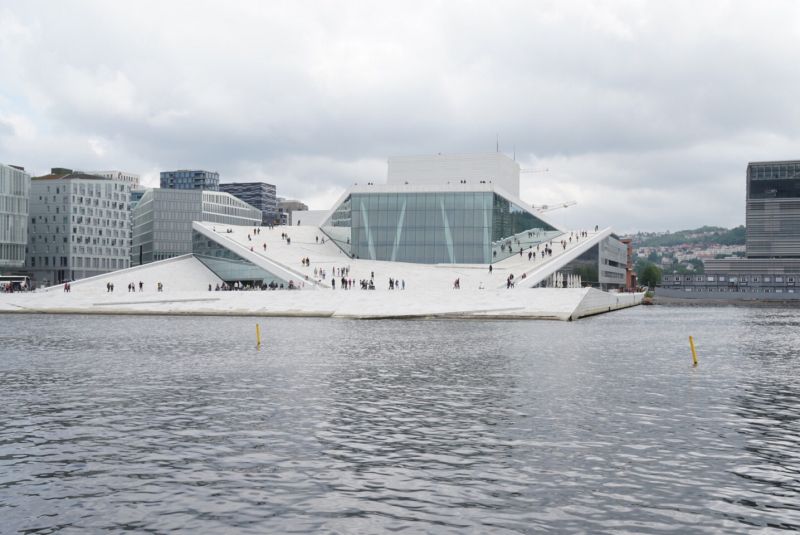
In der teuersten Hauptstadt Europas: Oslo
The starting point of our city walk is the landmark Operaen Oslo, whose accessible roof allows a wide view over the new district of Bjørvika, where we eat a super delicious burger to end our walk over the main station, the city palace, the national theater and the shopping street Karl Johans gate. The unusual hustle and bustle catapults us back into civilization.
Day
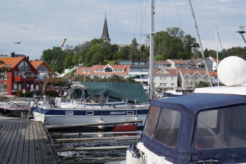
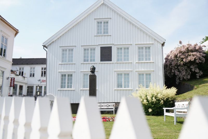
Grimstad
On the way to Kristiansand, where we take the ferry back to Denmark tomorrow, we pass Grimstad. We walk along the small marina and visit the places where Henrik Ibsen spent his younger years.
Grimstad, Norwegen
58° 20' 40.9" N 8° 35' 41.5" E
58.3447019 8.5948668
• Head toward Furuli terrasse on Furuheia. Go for 204 m.
• Turn left onto Furuliveien. Go for 496 m.
• Continue on Frivoldveien. Go for 114 m.
• Take the 2nd exit from roundabout onto Frivoldveien. Go for 378 m.
• Turn right onto Storgaten (3624). Go for 169 m.
• Continue on E18. Go for 153 m.
• Turn left and take ramp onto E18 toward Kristiansand. Go for 45.6 km.
• Take ramp toward Evje/Terminalen/E39/Danmark/Terminal. Go for 174 m.
• Take the 2nd exit from roundabout onto Vesterveien toward Stavanger/E39/Danmark. Go for 373 m.
• Take the 3rd exit from roundabout onto Vesterveien toward E39/Danmark. Go for 734 m.
• Arrive at Havnegata. Your destination is on the right.
☍
48,4 km
( 36 min.)
Day
Color Line Terminal Kristiansand
Vestre Strandgate 31, 4611 Kristiansand, Norwegen
58° 8' 40" N 7° 59' 23.5" E
58.1444502 7.9898554
• Head west on Havnegata. Go for 105 m.
• Turn sharp right toward Havnegata. Go for 40 m.
• Turn left onto Havnegata. Go for 243 m.
• Turn sharp left. Go for 447 m.
• Take the Kristiansand-Hirtshals Ferry. Stay on for 139 km.
• Head southeast on E39. Go for 131 m.
• Arrive at E39. Your destination is on the right.
☍
139,9 km
(4 hrs. 2 min.)
Color Line Terminal Hirtshals
9850 Hirtshals, Dänemark
57° 35' 34.1" N 9° 58' 5.9" E
57.5928139 9.9683145
• Head southwest on E39. Go for 2.0 km.
• Take the 3rd exit from roundabout onto Aalborgvej (E39) toward Aalborg/Skagen/597. Go for 2.3 km.
• Take the 2nd exit from roundabout onto E39 (Hirtshalsmotorvejen) toward Aalborg. Go for 57.0 km.
• Continue on Vendsyssel. Go for 196 m.
• Continue on E45 (Vendsyssel). Go for 57.7 km.
• Take exit 35 toward Hobro V/Skive. Go for 584 m.
• Turn left onto Skivevej (579) toward Hobro. Go for 3.1 km.
• Turn right onto Aalykkevej. Go for 289 m.
• Turn right onto Aalykkevej. Go for 699 m.
• Continue on Thostrup Hovgaard. Go for 737 m.
• Continue on Fyrkatvej. Go for 251 m.
• Arrive at Fyrkatvej.
☍
124,9 km
(1 hrs. 15 min.)
Wikingerburg Fyrkat
We have arranged a place to sleep for the night at a Viking castle near Hobro. Fyrkat is a round castle from the 10th century, attributed to King Bluetooth, and its architecture is unique in the world. The sunrise in the morning is terrific, we are standing in the middle of fields of fog and birdsong. That's van life. That's it.
Fyrkatvej, 9500 Hobro, Dänemark
56° 37' 23.9" N 9° 46' 12.9" E
56.6233183 9.7702585