Day
Stellplatz Am Kuhhirten
Great Camperstop for €17,- a night (2022) for maximum of 2 nights. No reservations possible, about 70 spots. Close to the city center of Bremen, a 20 minute walk or 5-10 minute bike ride away. Facilities are good and clean. You do have to buy a ticket for €1,- (1 per company is enough) to be able to enter the facilities until 14.00 the next day. And again a €1,- for a shower.
Electricity for a day is about €1.50 depending on how much power you use: you select the number of plug fitting your cable is in, then put €0.50 or a number of those coins in the electrical box to build up your power. Check regularly to make sure you don't run out. There's a coin change machine present at the entrance.
Kuhhirtenweg, 28201, Bremen, Duitsland
53° 3' 54" N 8° 49' 7" E
53.0650000 8.8186111
• Head toward Strandweg on Kuhhirtenweg. Go for 471 m.
• Continue on Werderstraße. Go for 754 m.
• Continue on Franziuseck. Go for 59 m.
• Turn right onto Wilhelm-Kaisen-Brücke. Go for 189 m.
• Turn left onto Martinistraße. Go for 721 m.
• Turn right onto Bürgermeister-Smidt-Straße. Go for 257 m.
• Turn right onto Am Wall. Go for 502 m.
• Arrive at Am Wall. Your destination is on the right.
☍
3,0 km
( 7 min.)
Day
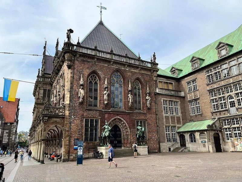
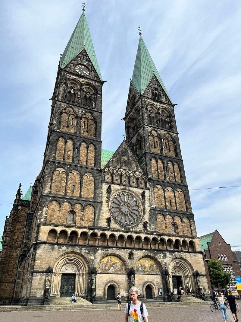
Bremen, Duitsland
Old city center of Bremen: beautiful cathedrals, platzen and buildings. A must see is the Böttcherstraße a small artful street with its Haus des Glockenspiels, a bell concert between 12.00 an 18.00 every whole hour. Dining at Paulaner's an der Schlachte for good German cuisine and big beers.
Mitte, Bremen, Duitsland
53° 4' 41.1" N 8° 48' 35.6" E
53.0780794 8.8098973
• Head toward Bischofsnadel on Am Wall. Go for 593 m.
• Continue on Altenwall. Go for 216 m.
• Turn left onto Osterdeich. Go for 3.0 km.
• Continue on Hastedter Osterdeich toward A1/Hamburg/Hannover/Rotenburg/Sebaldsbrück/Hemelingen. Go for 994 m.
• Turn left toward Hamburg-Osnabrück/Rotenburg/Sebaldsbrück/Weserhafen/Hemelingen. Go for 27 m.
• Turn slightly left onto Malerstraße. Go for 262 m.
• Turn right onto Pfalzburger Straße. Go for 848 m.
• Keep left onto Autobahnzubringer Hemelingen toward A1/Mahndorf/Arbergen. Go for 2.5 km.
• Take ramp onto A1 toward Hamburg/Hannover. Go for 79.8 km.
• Take exit 43 toward Flensburg/Kiel/Hamburg-West/Tötensen/Flughafen onto A261 (Buchholzer Dreieck). Go for 10.3 km.
• Continue on A7. Go for 11.6 km.
• Keep right onto A7. Go for 155 km.
• Take exit 2 toward Flensburg/Harrislee/Handewitt/Niebüll/Leck onto B199. Go for 1.9 km.
• Turn right onto Ellunder Straße (K30) toward Ellund. Go for 2.3 km.
• Turn left onto Flensburger Straße (L192). Go for 29.9 km.
• Turn right onto Hauptstraße (B5). Go for 2.0 km.
• Continue on Sønderløgumlandevej (11). Go for 3.3 km.
• Pass 4 roundabouts and continue on Ribelandevej (11). Go for 7.0 km.
• Take the 2nd exit from roundabout onto Ribelandevej (11) toward Ribe/175/Rømø. Go for 3.1 km.
• Take the 3rd exit from roundabout onto Hjerpstedvej toward Hjerpsted/419/Visby. Go for 1.9 km.
• Continue on Høybergvej. Go for 2.6 km.
• Continue on Trøjborgvej. Go for 1.9 km.
• Continue on Hjerpstedvej. Go for 12.6 km.
• Turn right onto Kystvej. Go for 263 m.
• Turn left onto Kystvej. Go for 64 m.
• Arrive at Kystvej. Your destination is on the right.
☍
334,1 km
(3 hrs. 27 min.)
Day
Ballum Camping
Refueling gas and groceries shopping just before the border of Denmark in Süderlügum (Germany is slightly cheaper than Denmark).
Arrival in Denmark at camping Ballum near Bredebro and the island of Rømø. The campsite is quite big 164 pitches and 16 special camper(van) pitches. It's child and dog friendly, it has a playground for the kids and a special swimming pond for dogs.
Facilities of the camping are very good and has everything you need! The showers and toilets are clean enough and can be found in two different places on the campsite. You'll get a shower card at the check in, and you will pay the amount of times you showered when you leave. Same goes for the electricity: you'll get an extra plug so it measures how much you use and you'll pay when you leave.
Kystvej 37, 6261, Ballum, Denemarken
55° 4' 7.2" N 8° 39' 41.7" E
55.0686573 8.6615719
• Head east on Kystvej.
• Arrive at Kystvej. Your destination is on the right.
☍
Distance not available
(Duration not available)
Day
Ballum Camping
Kystvej 37, 6261, Ballum, Denemarken
55° 4' 7.2" N 8° 39' 41.7" E
55.0686573 8.6615719
• Head east on Kystvej.
• Arrive at Kystvej. Your destination is on the right.
☍
Distance not available
(Duration not available)
Bredebro,
If you enjoy cycling, this area is definitely a nice place to cycle. Near the sea, but also the countryside's and little villages are charming. In Bredebro (13km from Ballum camping) you can get some groceries and go to an Ecco(shoes) store and a Lego store!
Day
Ballum Camping
Kystvej 37, 6261, Ballum, Denemarken
55° 4' 7.2" N 8° 39' 41.7" E
55.0686573 8.6615719
• Head toward Bunti on Kystvej. Go for 64 m.
• Turn right onto Kystvej. Go for 263 m.
• Turn right onto Kystvej (419). Go for 10.0 km.
• Turn right onto Rømøvej (175). Go for 3.8 km.
• Take the 4th exit from roundabout onto Ribevej (11) toward Ribe. Go for 17.2 km.
• Take the 2nd exit from roundabout onto Tøndervej (11) toward Ribe. Go for 649 m.
• Take the 2nd exit from roundabout onto Ringvejen (11/24) toward Varde/Esbjerg/Ribe N. Go for 2.4 km.
• Take the 2nd exit from roundabout onto Ringvejen (11/24) toward Varde/Esbjerg. Go for 2.2 km.
• Take the 2nd exit from roundabout onto Varde Hovedvej (11/24) toward Varde/Esbjerg. Go for 9.3 km.
• Keep left onto Tjæreborgvej (24) toward Esbjerg. Go for 10.7 km.
• Take the 2nd exit from roundabout onto Tjæreborgvej (24). Go for 3.1 km.
• Turn right toward Esbjerg N-V. Go for 294 m.
• Continue on E20 (Esbjergmotorvejen). Go for 4.4 km.
• Take exit 75 toward Blåvand. Go for 437 m.
• Take the 3rd exit from roundabout onto Vestkystvej (12/463) toward Blåvand. Go for 2.6 km.
• Take the 1st exit from roundabout onto Vestkystvej (12/463) toward Blåvand/Varde. Go for 4.0 km.
• Turn left onto Tarphagevej (447). Go for 2.1 km.
• Take the 1st exit from roundabout onto Tarphagevej (447). Go for 845 m.
• Take the 1st exit from roundabout onto Gudenåvej. Go for 1.4 km.
• Turn right onto Dalstrøget. Go for 59 m.
• Turn right onto Ådalen. Go for 127 m.
• Turn left onto Åmarken. Go for 115 m.
• Turn right onto Åbakken. Go for 251 m.
• Arrive at Åbakken. Your destination is on the left.
☍
76,2 km
(1 hrs. 5 min.)
Indoor kinda day
Didn't do much today, it was rainy and windy outside unfortunately. Tomorrow we'll go and see the island of Rømø on our way to our next stop in Denmark.
Day
Esbjerg Camping
Big family campsite. It was very clean, had enough facilities like a playground for the kids and a swimming pool. Also it was located great, it was close to the beach and to the center of Esbjerg (8km).
Gudenåvej 20, 6710, Esbjerg Vest, Denemarken
55° 30' 43" N 8° 23' 20" E
55.5119400 8.3888900
• Head toward Åmarken on Åbakken. Go for 21 m.
• Turn right onto Ådalen. Go for 514 m.
• Turn left onto Dalstrøget. Go for 59 m.
• Turn right onto Gudenåvej. Go for 331 m.
• Turn left onto Sædding Strandvej. Go for 2.8 km.
• Continue on Hjertingvej (447). Go for 394 m.
• Take the 2nd exit from roundabout onto Hjertingvej (447). Go for 1.7 km.
• Take the 3rd exit from Strandby Plads roundabout onto Strandbygade. Go for 1.0 km.
• Continue on Havnegade. Go for 598 m.
• Turn left onto Torvegade. Go for 163 m.
• Arrive at Torvegade. Your destination is on the right.
☍
7,7 km
( 12 min.)
Day
Streetfood Esbjerg, Borgergade, Esbjerg, Denemarken
We went to the beach in Hjerting and to the city center of Esbjerg. Ofcourse we saw the big white statues of the men at the sea: Mennesket ved havet.
The center was quiet because it was Sunday but you can always find a place to get something to eat and drink. We went for a place where they serve nice beers and ciders, and you can choose between different street foods from different countries, Mexican, Vietnamese, Italian or Greek for example.
Kongensgade 34, Borgergade 33, 6700 Esbjerg, Denemarken
55° 27' 56.4" N 8° 27' 10.1" E
55.4656752 8.4528087
• Head toward Borgergade on Torvegade. Go for 163 m.
• Turn left onto Havnegade. Go for 313 m.
• Turn right onto Jernbanegade (447). Go for 64 m.
• Turn left onto Gammelby Ringvej. Go for 1.6 km.
• Take the 3rd exit from roundabout onto Gammelby Ringvej (E20). Go for 1.1 km.
• Take the 2nd exit from roundabout onto Tjæreborgvej (E20). Go for 837 m.
• Keep left onto Tjæreborgvej (E20) toward Kolding/Varde. Go for 252 m.
• Take the 2nd exit from roundabout onto E20 (Esbjergmotorvejen) toward Kolding/Varde. Go for 65.4 km.
• Take the exit toward Odense/Århus onto E20/E45 (Sønderjyske Motorvej). Go for 8.1 km.
• Keep right onto E20 (Kolding) toward Odense/Fredericia. Go for 209 km.
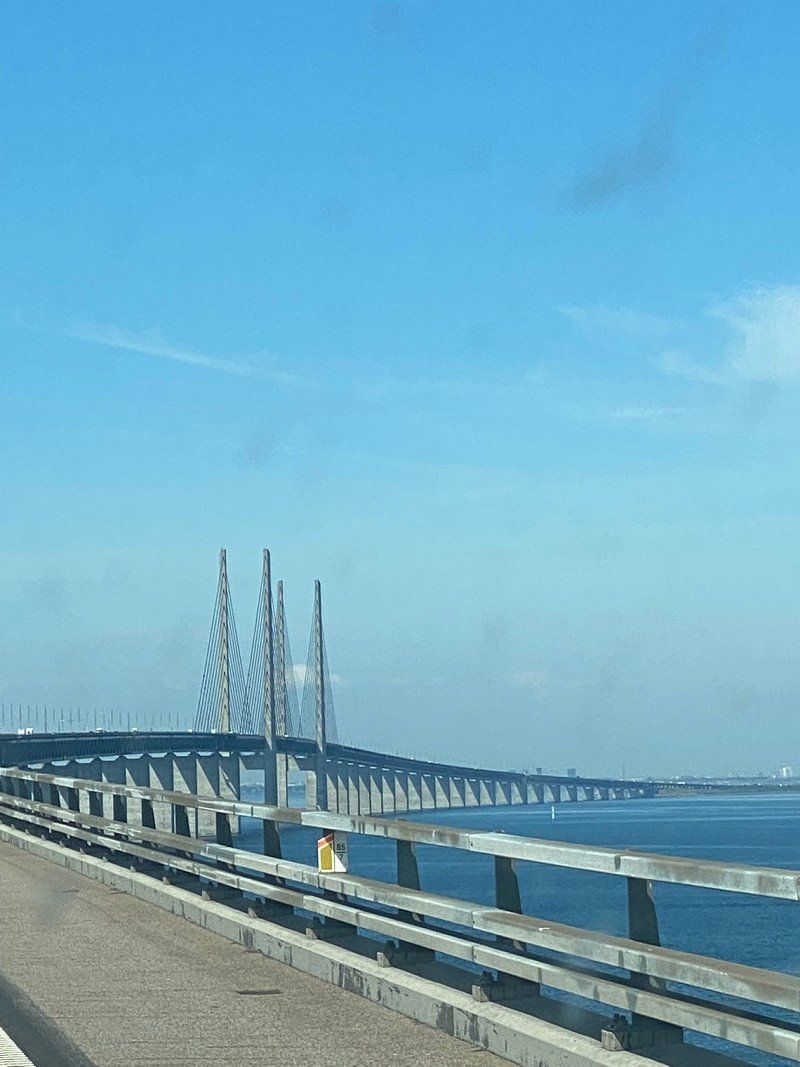
• Continue on E20 (Avedøre) toward Malmø/Lufthavn/København C. Go for 27.7 km.
• Continue on E20 (Öresundsbron). Go for 27.8 km.
• Continue on E6/E20 toward E4/Göteborg/Stockholm. Go for 5.1 km.
• Take exit 20 toward Lomma onto 103. Go for 1.2 km.
• Continue toward Centrum. Go for 48 m.
• Take the 2nd exit from Prästbergarondellen roundabout toward Centrum. Go for 196 m.
• Continue on Tenngatan. Go for 387 m.
• Continue on Järngatan. Go for 845 m.
• Take the 1st exit from roundabout onto Södra Västkustvägen. Go for 1.5 km.
• Turn left onto Södra Västkustvägen. Go for 216 m.
• Arrive at your destination on the left.
☍
352,2 km
(3 hrs. 19 min.)
Day
Habo-ljung Camping
Long way to Sweden, we would recommend a camping stop in between because the drive from Esbjerg to Lomma (near Malmö) took almost 7 hours because of traffic at the bridges. (Without traffic it would've only been about 4hours).
Camping site is okay, it's very big again. The pitches are irregular, different sizes, not very clear which are with electricity and which are without. You don't get a place assigned, you can choose one so you have to look closely where you park if so or don't want electricity. There are two facility places on the camping 1 is quite new and clean. The other place is old and very unclean.
Västkustvägen, 23434, Lomma, Zweden
55° 41' 21.4" N 13° 3' 25" E
55.6892800 13.0569400
• Head east. Go for 181 m.
• Continue on Södra Västkustvägen. Go for 35 m.
• Turn right onto Södra Västkustvägen. Go for 1.5 km.
• Take the 2nd exit from roundabout. Go for 557 m.
• Continue on Järngatan. Go for 429 m.
• Continue on Tenngatan. Go for 430 m.
• Take the 2nd exit from Prästbergarondellen roundabout toward E6/E20/Lund. Go for 266 m.
• Take ramp onto E6/E20 toward Malmö. Go for 4.4 km.
• Take exit 18 toward Malmö onto E22.10 (Stockholmsvägen). Go for 4.0 km.
• Continue on Stockholmsvägen toward Centrum. Go for 2.7 km.
• Keep left onto Stockholmsvägen. Go for 110 m.
• Turn left onto Hornsgatan toward C-Ring/Värnhemstorget/Stadion/Sjukhus. Go for 320 m.
• Turn right onto Nobelvägen toward E6/E20/Östervärn/Nobeltorget/Sjukhus. Go for 2.4 km.
• Turn right onto Spårvägsgatan toward Sjukhus. Go for 322 m.
• Turn right onto Claesgatan. Go for 43 m.
• Turn left onto Ahlmansgatan. Go for 76 m.
• Arrive at Ahlmansgatan. Your destination is on the right.
☍
17,7 km
( 19 min.)
Day
Malmö Center Bilvård, Ahlmansgatan, Malmö, Zweden
The city Malmöhas a few nice spots to visit, the st peters church and the Malmöhus. It's a comfortable city to walk around and feel relaxed. Get a drink or a bite to eat and walk some more.
Ahlmansgatan 4, 214 27 Malmö, Zweden
55° 35' 22" N 13° 0' 23" E
55.5894410 13.0064017
• Head toward Claesgatan on Ahlmansgatan. Go for 200 m.
• Turn right onto Bangatan. Go for 80 m.
• Turn left onto Spårvägsgatan. Go for 190 m.
• Turn left onto Nobelvägen. Go for 2.5 km.
• Continue on Hornsgatan. Go for 263 m.
• Keep right onto Stockholmsvägen toward Stockholm/E4/Göteborg/E6/Landskrona/E22/Kalmar/11/Simrishamn/Lund. Go for 2.8 km.
• Continue on E22.10 (Stockholmsvägen). Go for 2.9 km.
• Take the exit toward Stockholm/E4 onto E6/E20. Go for 57.0 km.
• Take exit 30A toward Stockholm onto E4. Go for 224 km.
• Take the 2nd exit from roundabout onto 40 toward Göteborg/Flygplats. Go for 4.8 km.
• Take ramp toward Trollhättan/Hjo/Sandseryd/Jönköpings flygplats/Hedenstorp. Go for 214 m.
• Turn right onto 26/47 toward 195/Mariestad/Trollhättan/Hjo. Go for 13.0 km.
• Turn right onto Habovägen. Go for 43 m.
• Turn left onto Domsand. Go for 224 m.
• Continue on Fiskebäckstomt. Go for 147 m.
• Turn right. Go for 15 m.
• Arrive at your destination on the left.
☍
308,7 km
(2 hrs. 57 min.)
Day
Habo Camping
Domsandsliden 2, 56635, Habo, Zweden
57° 52' 42" N 14° 6' 39.5" E
57.8783400 14.1109700
• Head toward Domsand. Go for 110 m.
• Turn left onto Domsand. Go for 57 m.
• Continue on Fiskebäckstomt. Go for 152 m.
• Continue on Domsand. Go for 224 m.
• Turn right onto Habovägen. Go for 43 m.
• Turn right onto 195. Go for 2.3 km.
• Pass 3 roundabouts and continue on 195. Go for 73.6 km.
• Turn right onto 49. Go for 105 m.
• Turn left onto Hjovägen. Go for 347 m.
• Continue on Järnvägsgatan. Go for 232 m.
• Continue on Centralgatan. Go for 296 m.
• Take the 2nd exit from roundabout onto Forsviksvägen. Go for 2.2 km.
• Continue on Vaberget Dampegården. Go for 2.8 km.
• Continue on Gällsebo skola. Go for 79 m.
• Continue on Gällsebo. Go for 664 m.
• Continue on Gällsebo Sörvik. Go for 43 m.
• Continue on Gällsebo. Go for 1.1 km.
• Continue on Hulängen. Go for 125 m.
• Continue on Hulängen Hagalund. Go for 2.6 km.
• Continue on Baltzar von Platens väg. Go for 1.4 km.
• Turn left onto 202. Go for 1.3 km.
• Turn left onto Strömsnäs camping. Go for 486 m.
• Arrive at Strömsnäs camping. Your destination is on the right.
☍
90,3 km
(1 hrs. 13 min.)
Day
Day
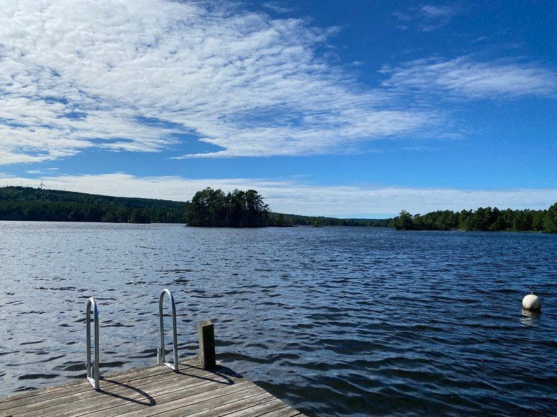
Strömsnäs Naturcamping
Loved this camping site, great facilities, nice owners but most of all, a fantastic view.
54673, Forsvik, Zweden
58° 35' 25.2" N 14° 24' 18.3" E
58.5903300 14.4050800
• Head south on Strömsnäs camping. Go for 486 m.
• Turn right onto 202. Go for 5.5 km.
• Turn left onto 49. Go for 41.8 km.
• Take ramp onto Bergslagsdiagonalen (50) toward Jönköping/Motala. Go for 32.7 km.
• Turn left onto Ängesby toward 34/Linköping/Kolmetorp. Go for 78 m.
• Continue on Stora Ängesby. Go for 3.5 km.
• Continue on Kartorp. Go for 150 m.
• Continue on Evertsbyvägen. Go for 1.9 km.
• Turn left onto Östermalmsgatan (34). Go for 37.1 km.
• Keep left onto Trafikplats Linköping västra (34) toward E4/Stockholm/Vimmerby/Linköping V/Flygplats/Sjukhus. Go for 514 m.
• Keep right onto E4.4 (Malmslättsvägen) toward Vimmerby/Linköping V/Sjukhus. Go for 3.1 km.
• Take the exit toward Växjö/Vimmerby/Kisa/Jägarvallen/Mjärdevi Science park/Sjukhus. Go for 323 m.
• Take the 1st exit from roundabout onto Nya Kalmarvägen (23/34) toward Vimmerby/Kisa/Jägarvallen/Mjärdevi Science park/Sjukhus. Go for 548 m.
• Pass 4 roundabouts and continue on Vimmerbyvägen (23/34). Go for 90.3 km.
• Take the 3rd exit from roundabout onto 40 toward Västervik/Vimmerby S. Go for 1.5 km.
• Take the 2nd exit from roundabout onto 40 toward Västervik/Astrid Lindgrens Värld. Go for 2.3 km.
• Turn right onto Nosshult toward Nossenbaden. Go for 110 m.
• Continue on Grägarpsvägen. Go for 187 m.
• Turn right onto Sjöhagavägen. Go for 111 m.
• Turn left onto Höknäsvägen. Go for 69 m.
• Turn slightly left onto Höknäsvägen. Go for 7 m.
• Arrive at Höknäsvägen. Your destination is on the left.
☍
222,5 km
(2 hrs. 38 min.)
Day
Day
Day
Vimmerby Camping
Nosshult 108, 59893, Vimmerby, Zweden
57° 39' 46" N 15° 53' 52.5" E
57.6627700 15.8979300
• Head southwest on Höknäsvägen. Go for 76 m.
• Turn right onto Sjöhagavägen. Go for 111 m.
• Turn left onto Grägarpsvägen. Go for 187 m.
• Continue on Nosshult. Go for 110 m.
• Turn left onto 40. Go for 2.3 km.
• Take the 2nd exit from roundabout onto 40 toward 23/34/Jönköping. Go for 1.5 km.
• Take the 3rd exit from roundabout onto 23/34 toward Växjö/Kalmar. Go for 15.9 km.
• Take the 2nd exit from roundabout onto 23/34 toward Växjö/Kalmar/Centrum. Go for 14.7 km.
• Take the 1st exit from roundabout onto 23/47 toward Växjö/Jönköping. Go for 3.1 km.
• Take the 2nd exit from roundabout onto 23 toward Växjö/Åseda/Virserum. Go for 33.6 km.
• Turn right onto 23/37 toward Växjö/Åseda. Go for 33.6 km.
• Continue on 23/37. Go for 16.9 km.
• Take the 2nd exit from Sandsbrorondellen roundabout onto 23/37. Go for 3.2 km.
• Take the 2nd exit from Norremarksrondellen roundabout onto Norrleden (23/25/27). Go for 4.5 km.
• Keep left onto Norrleden (23/27) toward Malmö. Go for 76.1 km.
• Take the 2nd exit from roundabout toward Malmö. Go for 119 m.
• Continue on 23. Go for 2.5 km.
• Take the 2nd exit from roundabout onto 23 toward 19/19 S. Go for 8.6 km.
• Take ramp onto 23 toward Malmö/Hässleholm. Go for 18.1 km.
• Take the 2nd exit from roundabout onto 23 toward Hässleholm Ö/Malmö/Läreda. Go for 1.3 km.
• Turn left and take ramp onto 21 toward Kristianstad. Go for 3.5 km.
• Take ramp toward Attarp/Ignaberga. Go for 359 m.
• Turn right toward Ignaberga. Go for 61 m.
• Turn left toward Kristianstad. Go for 227 m.
• Continue on Ignaberga. Go for 649 m.
• Turn right onto Ignaberga. Go for 188 m.
• Turn left toward Ignaberga. Go for 28 m.
• Continue on Ignaberga. Go for 512 m.
• Turn left onto Tykarp. Go for 50 m.
• Arrive at Tykarp. Your destination is on the left.
☍
242,0 km
(2 hrs. 44 min.)
Day
Day
Tykarpsgrottan - besöksgruva & camping, Hässleholm, Zweden
An relaxed stay for 1 day. You can get a small tour through the caves /mining tunnels underneath the camping site. The tour was in Swedish but as Dutch people we understood most of the information.
The facilities at the campsite were definitely good enough for a day.
In the late afternoon and evening we got to see a car and motor meeting at the camping sites. As a classic car enthusiast it was a fantastic bonus.
Tykarp 7169, 281 92 Hässleholm, Zweden
56° 7' 6.1" N 13° 49' 33.6" E
56.1183590 13.8259970
• Head north on Tykarp. Go for 50 m.
• Turn left toward Tykarp. Go for 299 m.
• Turn right onto Tykarp. Go for 491 m.
• Continue toward Ignaberga. Go for 90 m.
• Continue on Ignaberga. Go for 156 m.
• Turn left onto Ignaberga. Go for 727 m.
• Continue on Gulastorp. Go for 770 m.
• Turn left onto 23. Go for 13.5 km.
• Take ramp toward Häglinge/Sösdala. Go for 184 m.
• Turn right onto Länsmansgatan toward Häglinge. Go for 122 m.
• Continue on Sjöcronas gata. Go for 856 m.
• Continue on Fredriksberg. Go for 1.7 km.
• Continue on Röslöv. Go for 1.7 km.
• Continue on Västra Häglinge. Go for 627 m.
• Continue on Häglinge. Go for 177 m.
• Continue on Häglinge. Go for 70 m.
• Continue on Häglinge. Go for 190 m.
• Continue on Västra Häglinge. Go for 183 m.
• Turn left onto Häglinge. Go for 381 m.
• Continue on Västra Häglinge. Go for 169 m.
• Continue on Häglinge. Go for 2.7 km.
• Continue on Fundersed. Go for 3.9 km.
• Continue on Södra Rörum. Go for 409 m.
• Continue on Södra Rörum Häglingevägen. Go for 552 m.
• Turn left onto Södra Rörum Hörbyvägen. Go for 2.6 km.
• Continue on Fulltofta. Go for 4.3 km.
• Turn right and take ramp onto E22 toward Lund. Go for 44.3 km.
• Take exit 18 toward Trelleborg/Limhamn onto E6/E20/E22 (Yttre Ringvägen). Go for 15.5 km.
• Continue on E20 (Yttre Ringvägen) toward Flygplats/Köpenhamn/Limhamn. Go for 13.7 km.
• Continue on E20 (Øresundsbroen). Go for 29.2 km.
• Take exit 25 toward Vallensbæk S/Brøndbyvester/Vallensbæk Str. Go for 463 m.
• Turn left onto Søndre Ringvej (O3) toward Ishøj/Vallensbæk Str. Go for 3.8 km.
• Take the 2nd exit from roundabout onto Ishøj Strandvej (151) toward Køge. Go for 1.3 km.
• Arrive at Hundige Strandvej (151). Your destination is on the right.
☍
145,0 km
(1 hrs. 36 min.)
Day
Hundige Strand Familiecamping
Hundige Strandvej 72, 2670, Greve, Denemarken
55° 35' 42.1" N 12° 20' 39" E
55.5950300 12.3441600
• Head southwest on Hundige Strandvej (151). Go for 391 m.
• Turn right onto Hundige Centervej. Go for 705 m.
• Take the 3rd exit from roundabout onto Hundige Centervej. Go for 530 m.
• Turn slightly right onto Hundige Centervej. Go for 963 m.
• Continue on Kildebrøndevej. Go for 491 m.
• Turn left and take ramp onto E20/E47 (Køge Bugt Motorvejen) toward Rødby/Odense. Go for 17.3 km.
• Keep left onto E20 (Køge Vest) toward Odense. Go for 174 km.
• Keep left onto E20 (Fredericia) toward Esbjerg/E45s/Kolding/Flensborg. Go for 15.5 km.
• Continue on E45 (Sønderjyske Motorvej) toward Flensborg. Go for 50.8 km.
• Take the exit. Go for 386 m.
• Take the 2nd exit from roundabout onto Bodumvej. Go for 143 m.
• Continue on Rødekrovej Vest. Go for 710 m.
• Take the 2nd exit from roundabout onto Rødekrovej Øst. Go for 893 m.
• Continue on Bodum Bygade. Go for 2.4 km.
• Turn right onto Haderslevvej (170). Go for 207 m.
• Take the 2nd exit from roundabout onto Bodumvej toward Barsø/Løjt Kirkeby. Go for 2.1 km.
• Continue on Løjt Storegade. Go for 465 m.
• Turn right onto Løjt Nørregade. Go for 592 m.
• Turn left onto Barsøvej. Go for 635 m.
• Continue on Sandskærvej. Go for 2.3 km.
• Turn slightly left onto Sandskærvej. Go for 482 m.
• Arrive at Sandskærvej.
☍
272,3 km
(2 hrs. 37 min.)
Day
Day
Day
Sandskaer Strandcamping
Sandskærvej 592, 6200, Aabenraa, Denemarken
55° 7' 7.1" N 9° 29' 43" E
55.1186300 9.4952700
• Head toward Løjt Feriecenter 1 on Sandskærvej. Go for 2.8 km.
• Continue on Barsøvej. Go for 635 m.
• Turn right onto Løjt Nørregade. Go for 592 m.
• Turn left onto Løjt Storegade. Go for 465 m.
• Continue on Bodumvej. Go for 2.0 km.
• Take the 1st exit from roundabout onto Haderslevvej (170) toward Haderslev/24/Rødekro/E45. Go for 226 m.
• Turn left onto Bodum Bygade. Go for 2.4 km.
• Continue on Rødekrovej Øst. Go for 866 m.
• Take the 3rd exit from roundabout onto Gammel Ribevej. Go for 818 m.
• Take the 2nd exit from roundabout onto Gammel Ribevej. Go for 904 m.
• Turn right onto Erik Jessens Vej. Go for 327 m.
• Take the 2nd exit from roundabout onto Erik Jessens Vej. Go for 786 m.
• Turn right onto Løgumklostervej (24). Go for 421 m.
• Take the 3rd exit from roundabout onto Løgumklostervej (24) toward Flensborg/E45/Ribe/Rødekro/429. Go for 259 m.
• Take the 3rd exit from roundabout onto E45 (Sønderjyske Motorvej) toward Flensborg. Go for 30.5 km.
• Continue on A7. Go for 156 km.
• Keep left onto A7. Go for 14.7 km.
• Keep right onto A261 (Autobahndreieck Hamburg-Südwest) toward Bremen/Tötensen. Go for 9.0 km.
• Take exit 4 toward Osnabrück/Bremen/Rade onto A1. Go for 202 km.
• Take exit 72 toward Amsterdam/Rheine onto A30. Go for 49.1 km.
• Take exit 5 toward Oberhausen/Schüttorf-Ost onto A31. Go for 2.9 km.
• Take exit 28 toward Schüttorf-Ost/Bad Bentheim. Go for 237 m.
• Turn left onto Salzbergener Straße (L39) toward Schüttorf. Go for 612 m.
• Take the 3rd exit from roundabout onto Holmers Kamp toward Ohne/Gewerbegebiet Süd. Go for 1.0 km.
• Turn left onto Samernsche Straße (L68). Go for 149 m.
• Continue on Schüttorfer Straße (L68). Go for 1.7 km.
• Turn right onto Schüttorfer Straße (L68) toward Ohne. Go for 956 m.
• Turn right onto Ohner Straße (K8). Go for 891 m.
• Turn left onto Postweg (K9). Go for 2.3 km.
• Continue on Suddendorfer Straße (K9). Go for 238 m.
• Turn right onto Suddendorfer Straße. Go for 235 m.
• Arrive at Suddendorfer Straße. Your destination is on the left.
☍
485,6 km
(4 hrs. 31 min.)
Day
Day
Camping Am Berg
Suddendorferstr. 37, 48455, Bad Bentheim, Duitsland
52° 17' 58.7" N 7° 11' 36.4" E
52.2996500 7.1934500