The land route Hamburg-Flanders, called the "Flemish Street", led from Hamburg via present-day Altona to the village of Blankenese, where it crossed the Elbe.
From the west bank of this river the trade route then led via Buxtehude to Stade, then to Bremervörde, after which Bremen was reached via the villages of Basdahl and Osterholz. Here they crossed the Weser, and then continued in a southwesterly direction: over Delmenhorst, Wildeshausen, Ahlhorn, Kloppenburg, Löningen, Haselünne, Lingen, Nordhorn, Ootmarsum, Goor, Holten, Deventer, Arnhem, Nijmegen, Grave, 's- Hertogenbosch, Tilburg, Hoogstraten, Antwerp, to finally reach Bruges via Eecloo.
As for the passage through the regions of the Netherlands, a journey de Brugis usque ad Lubeke, described in the Itinerarium de Brugis of the end of the fourteenth century, differs from the indicated route.
According to this medieval travel guide, the journey from Bruges to Lübeck leads via Antwerp, Breda, then to Geertruidenberg, Dordrecht, Schoonhoven, Utrecht, Hattem, Zwolle, Dalfsen, Hardenberg, Veldhausen, after which one enters Lingen on the normal commercial road, the 'Flemish street, " came.
The Lübeck-Bruges overland journey, which took about ten to twelve days, has been repeatedly reported in reports of the missions of envoys and messengers.
documented.
The end of the Hanseatic League
The Hanseatic League was a fantastic means of international trade in Europe, the many Hanseatic cities that worked together have achieved a lot. Nevertheless, the German member association the Hanze comes to an end, the Hanze has provided a lot of trade, but of course there is always expansion.
At the beginning of the 16th century, the Hanseatic League became weak, the Hanseatic cities became obsolete and trade was carried out over greater distances, over the larger seas.
Amsterdam and Antwerp in particular became major trading cities in the Netherlands. As a result, the Hanseatic League almost collapsed, more and more countries ensured that the Hanseatic League no longer had power over (part of) their country and more and more cities found their own interests more important than the Hanseatic League.
Of course not everyone just gave up on the Hanze, for example another Hanze office was moved from Bruges to Antwerp. Unfortunately, it was of no avail and the Hanze remained in decline, more and more Hanze offices closed their doors. The Thirty Years' War (from 1618 to 1648) caused a lot of misery for the Hanseatic League, the war destroyed almost everything. The last Hanseatic Day was in 1669 and then only nine cities registered (there were almost 200!), the final end of the Hanseatic League was in 1862, only three cities were still members, namely Bremen, Hamburg and Lübeck.
The new Hanseatic League
Despite the decline of the Hanseatic League, many cities still attach great importance to the title they once had. The name Hanseatic city is still common in this time and everyone has heard of it, this is due to the value that the cities still attach to it. In the Netherlands, the cities of Deventer, Zwolle, Kampen, Groningen, Oldenzaal, Harderwijk and Zutphen still proudly call themselves a Hanseatic city.
This enthusiasm has also ensured that a new Hanseatic League has emerged, not to trade between the cities, but in the cultural and tourist field. The new Hanze was founded in 1980 in the Hanseatic city of Zwolle, this new Hanze also has its usual meetings in the various Hanseatic cities.
The project "Cross-border cooperation Hanseatic cities then and now" is a collaboration between fourteen Hanseatic cities in the Dutch - German border region. Support for the project is a network consisting of regional (tourist) organisations, the local tourist offices, the municipalities and a cluster of (tourist) companies along the route.
Hanseatic Museum Deventer Netherlands. https://www.hoteldeleeuw.nl/hanze-museum
European Hanseatic Museum Lübeck Germany. https://www.hansemuseum.eu/en/
Hanseatic Museum Antwerp Belgium. https://mas.be/nl/Vracht
Via the izi.Travel app you can make city walks with audio support in all Hanseatic cities, except in Lübeck.
Source: De Hanze en Vlaanderen 1950 by Jozef Hubert Beuken publisher Ernest van Aelst in Maastricht
https://onzesteden.nl/hanzesteden/#story
https://deutschland-nederland.eu/nl/hanzesteden-blikken-back-on-successful-cooperation/
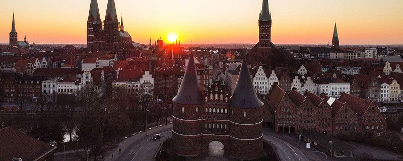
Lübeck, Duitsland
During the 12th to the 16th century, many cities from Germany and the Netherlands worked closely together. Together they tried to trade as much as possible and to earn money from the merchants from Russia and Scandinavia. These cities worked together in a kind of alliance also called the Hanseatic League. In addition to Lübeck, there are many more Hanseatic cities in Germany, Belgium and the Netherlands. Famous Hanseatic cities from the Netherlands were Groningen, Nijmegen, Arnhem, Doesburg, Hattem, Antwerp and Bruges. In Germany Lübeck, Hamburg and Bremen.
The Hanseatic cities used commercial contracts which were drawn up according to Lübeck law when trading. With this law, modern for that time, the agreements between the traders and merchants were tested against the case law and the fulfillment of the agreement could be enforced in this way by a recognized court.
City walk. https://www.routeyou.com/nl-de/route/view/6569191/recreatieve-wandelroute/stadswandel-lubeck-ontdek-de-fortingenstad-aan-de-trave
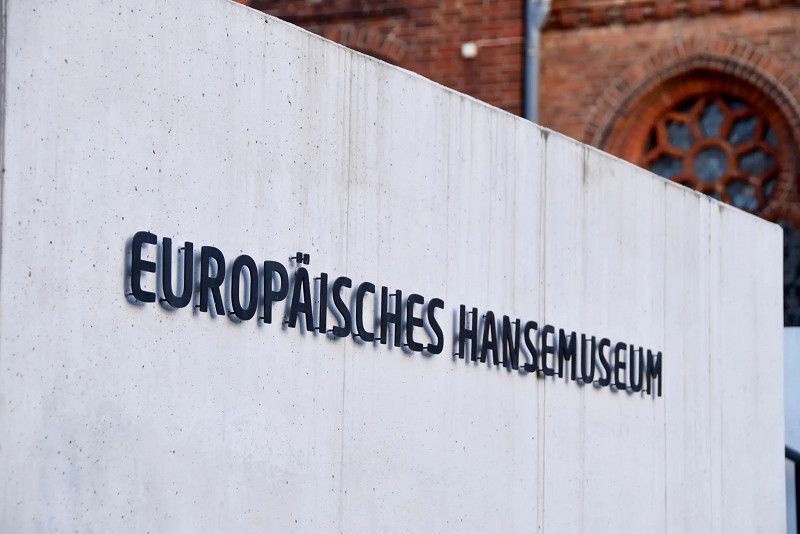
Photo Hanseatic city of Lübeck and the Hanseatic Museum
Source: https://www.allesoverduitsland.nl/steden/lubeck/
53° 51' 59.2" N 10° 41' 5.1" E
53.8664440 10.6847380
• Head toward Kolk on Holstenstraße. Go for 200 m.
• Continue on Holstenbrücke. Go for 44 m.
• Continue on Holstentorplatz. Go for 291 m.
• Continue on Puppenbrücke. Go for 20 m.
• Turn right onto Lindenplatz (L332). Go for 2.2 km.
• Turn sharp right onto Stockelsdorfer Straße (K26) toward Puttgarden/A1/Hamburg/Rostock/Lohmühle Stadion. Go for 227 m.
• Take ramp onto A1 toward Hamburg/Rostock/A20. Go for 49.9 km.
• Take exit 31 toward Hamburg/HH-Jenfeld onto A24. Go for 7.4 km.
• Take the 1st exit from Horner Kreisel roundabout onto Sievekingsallee toward Elbbrücken/Stadion Arena/Centrum. Go for 2.1 km.
• Continue on Bürgerweide. Go for 816 m.
• Keep left onto Bürgerweide (B75) toward Elbbrücken. Go for 509 m.
• Turn right onto Spaldingstraße. Go for 1.0 km.
• Continue on Amsinckstraße (B4). Go for 163 m.
• Keep left onto B4 toward Altona/A7/Centrum/Messe/CCH. Go for 849 m.
• Turn right onto Brandstwiete. Go for 90 m.
• Continue on Alter Fischmarkt. Go for 79 m.
• Turn right onto Domplatz. Go for 212 m.
• Continue on Steinstraße. Go for 71 m.
• Turn left onto Jakobikirchhof. Go for 83 m.
• Arrive at Jakobikirchhof. Your destination is on the right.
☍
66,3 km
( 46 min.)
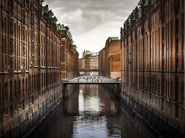
Hamburg, Duitsland
Products from Hamburg and its hinterland, which goods the Hanseatic League exported to Flanders, among others. These included pitch and wood, especially wainscot or ship's wood. Furthermore, melevate and molden or lucghen (bakers' kneading baking), ashes, necessary for cleaning the wole, finally grains and metals. was a much more common drink at that time than it is today. In the thirteenth century Bremen beer had priority in Flanders, in the course of the fourteenth century it was pushed out of the market by the "Oriental" or Hamburg beer. in the fourteenth century one of the most important branches of existence for the Hamburgers.
An old Hanseatic proverb calls Hamburg the 'brewer house of the Hanseatic League. Large quantities of Oriental beer were exported to Flanders. As late as 1436, an English mocking poet calls the Orientals indispensable for Flanders, if only because of their beer.
Guided tour with audio support https://izi.travel/nl/7dd1-urbirun-hamburg-highlights/en
Photo: Hanseatic City of Hamburg
Source: Pixabay
53° 33' 1.2" N 10° 0' 2.4" E
53.5503410 10.0006540
• Head toward Steinstraße on Jakobikirchhof. Go for 83 m.
• Turn left onto Steinstraße. Go for 389 m.
• Turn right onto Klosterwall toward Flensburg/A7/Harburg. Go for 212 m.
• Keep left onto Deichtorplatz toward Elbbrücken/Bergedorf/Harburg/B4. Go for 269 m.
• Keep right onto Recha-Lübke-Damm toward Bremen/A1/Hannover/Elbbrücken/B4/Harburg. Go for 511 m.
• Continue on Amsinckstraße (B4) toward Elbbrücken/Harburg. Go for 2.7 km.
• Continue on A255. Go for 1.0 km.
• Take the exit toward HH-Wilhelmsburg/HH-Georgswerder onto B75 (Wilhelmsburger Reichsstraße). Go for 8.1 km.
• Take ramp toward HH-Harburg-Mitte. Go for 234 m.
• Turn right onto Großmoordamm (B73) toward Flensburg/A7/Cuxhaven/Stade/Neugraben. Go for 480 m.
• Turn right onto Hannoversche Straße (B73) toward Cuxhaven/A7/Neugraben/Krankenhaus AK Harburg. Go for 13.7 km.
• Turn right onto Bahnhofstraße. Go for 1.1 km.
• Take the 2nd exit from roundabout onto Bahnhofstraße. Go for 483 m.
• Take the 2nd exit from roundabout. Go for 194 m.
• Continue on Wulmstorfer Wiesen. Go for 184 m.
• Take the 1st exit from Wulmstorfer Wiesen roundabout onto Achtern Bahnhof. Go for 110 m.
• Turn right onto B3. Go for 1.5 km.
• Turn right and take ramp. Go for 301 m.
• Turn left onto A26. Go for 23.5 km.
• Take the exit toward Stade Zentrum/Stade-Ottenbeck/Gewerbegebiet Süd. Go for 266 m.
• Take the 1st exit from roundabout onto Harburger Straße. Go for 1.8 km.
• Take the 3rd exit from roundabout onto Harburger Straße. Go for 535 m.
• Turn right toward Hansebrücke. Go for 75 m.
• Continue on Hansebrücke. Go for 294 m.
• Turn right onto Salztorswall toward Altes Land/Elbefähre/Wischhafen. Go for 112 m.
• Turn left onto Kleine Archivstraße. Go for 127 m.
• Turn left onto Archivstraße. Go for 74 m.
• Continue on Am Sande. Go for 74 m.
• Turn right onto Poststraße. Go for 104 m.
• Arrive at Poststraße. Your destination is on the left.
☍
58,6 km
( 56 min.)
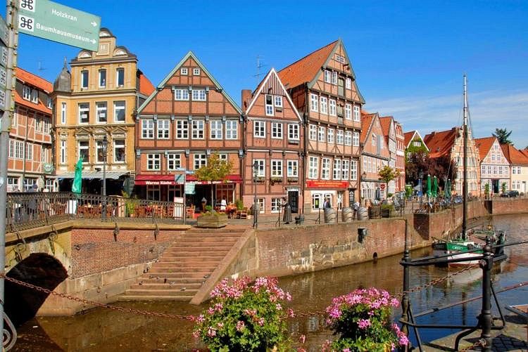
Stade, Duitsland
Stade is perhaps the oldest city in Northern Germany! In 1000 BC people already settled here. In the 8th century BC a permanent settlement with a harbor was established and in 1209 Stade received city rights.
The city became an administrative center under Swedish rule (1645-1712), maintained a garrison (army) and built an impressive fortress.
The historic center of the city is located within the former city wall on Schwinge Island. Formerly, because when the city started to fill up at the end of the 19th century, the walls were demolished and converted into green strips.
Stade was a prosperous "Hanseatic city" in the Middle Ages
Source: https://thetraveltester.com/nl/wat-is-een-hanzestad/
53° 35' 59.3" N 9° 28' 31.6" E
53.5997940 9.4754380
• Head toward Behördenhaus on Poststraße. Go for 104 m.
• Turn right onto Am Sande. Go for 13 m.
• Turn left onto Am Sande. Go for 84 m.
• Turn slightly right toward Holzstraße. Go for 11 m.
• Turn slightly left onto Holzstraße. Go for 73 m.
• Turn sharp right onto Wallstraße. Go for 572 m.
• Take the 3rd exit from roundabout onto Schiffertorsstraße. Go for 784 m.
• Take the 3rd exit from roundabout onto Bremervörder Straße toward Cuxhaven/Bremerhaven/Elbe Klinikum. Go for 2.3 km.
• Continue on An der B74 (B74) toward Bremen/Bremerhaven. Go for 1.1 km.
• Continue on An der Bundesstraße 74 (B74). Go for 16.5 km.
• Continue on Elmer Landstraße (B74) toward Bremervörde. Go for 6.2 km.
• Continue on Neue Straße (B71/B74). Go for 1.0 km.
• Turn left onto Dammstraße. Go for 199 m.
• Turn slightly right onto Johann-Kleen-Straße. Go for 362 m.
• Arrive at Johann-Kleen-Straße. Your destination is on the right.
☍
29,4 km
( 27 min.)
Bremervörde, Duitsland
Bremervörde, 27432, Duitsland
53° 29' 6.1" N 9° 8' 10.4" E
53.4850249 9.1362085
• Head toward Ludwigstraße on Johann-Kleen-Straße. Go for 362 m.
• Turn right onto Alte Straße. Go for 281 m.
• Take the 2nd exit from roundabout onto Alte Straße. Go for 293 m.
• Turn right onto Bremer Straße. Go for 416 m.
• Continue on Gnarrenburger Straße. Go for 1.6 km.
• Take the 2nd exit from roundabout onto Gnarrenburger Straße (K102). Go for 672 m.
• Continue on Spreckenser Landstraße (K102). Go for 2.8 km.
• Continue on Fahrendorf (K102). Go for 3.3 km.
• Continue on Fahrendahl (K102). Go for 1.9 km.
• Continue on Langenhausen (K102). Go for 4.0 km.
• Continue on Barkhausen (K102). Go for 1.4 km.
• Continue on Am Kanal (K102). Go for 29 m.
• Turn left onto Carlshütte (L122). Go for 2.1 km.
• Turn right onto Bremer Straße (L165) toward Bremen/Worpswede/Ostersode. Go for 12.2 km.
• Continue on Neu Sankt Jürgener Straße (L153). Go for 5.0 km.
• Turn right onto Findorffstraße (K11). Go for 1.1 km.
• Continue on Osterholzer Straße (K11). Go for 1.5 km.
• Continue on Waakhauser Straße (K11). Go for 2.8 km.
• Continue on Viehlander Straße (K11). Go for 2.7 km.
• Turn left onto K9 toward A27/Bremen/Ritterhude/Lilienthal. Go for 1.1 km.
• Turn right onto Niederende (K8) toward A27/Bremen/Ritterhude. Go for 5.5 km.
• Continue on Ritterhuder Heerstraße (L151). Go for 2.8 km.
• Take ramp onto A27 toward Hannover. Go for 6.0 km.
• Take exit 18 toward Bremen-Überseestadt/Bremen-Centrum/Flughafen/GVZ onto B6 (Autobahnzubringer Überseestadt). Go for 1.3 km.
• Keep left onto Autobahnzubringer Überseestadt (B6) toward Centrum/Überseestadt/GVZ. Go for 2.2 km.
• Take ramp onto Breitenweg toward Weserstadion/Centrum/Hauptbahnhof. Go for 907 m.
• Keep right onto Breitenweg toward Hauptbahnhof/Centrum. Go for 346 m.
• Turn right onto Bürgermeister-Smidt-Straße toward Neustadt. Go for 712 m.
• Turn left onto Martinistraße. Go for 559 m.
• Keep right onto Martinistraße. Go for 157 m.
• Make a U-Turn at Wilhelm-Kaisen-Brücke onto Martinistraße. Go for 98 m.
• Turn right onto Wachtstraße. Go for 149 m.
• Arrive at Wachtstraße. Your destination is on the left.
☍
66,2 km
(1 hrs. )
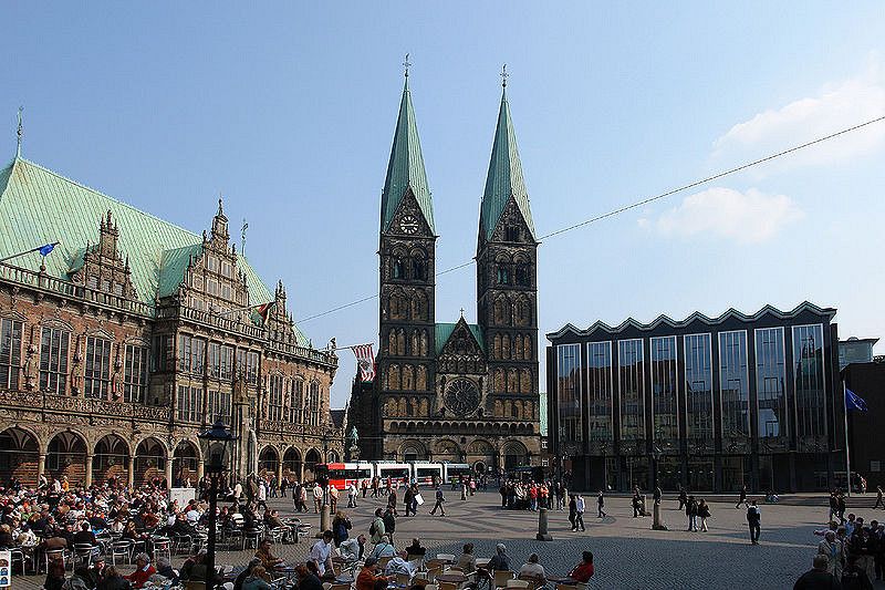
Bremen, Duitsland
Bremen was first mentioned in 782. Five years later, Charlemagne founded a bishopric there and the city became a focal point for the Christianization of Northern Europe. In 1260, the city joined the Hanseatic League for the first time, but conflicts with the other Hanseatic cities led to Bremen being expelled from the alliance three times. Tour with audio support https://izi.travel/nl/1d6c-hello-bremen/en
Photo: Hanseatic city of Bremen
Source: Wikipedia
Source: https://nl.wikipedia.org/wiki/Bremen_(stad)
53° 4' 33" N 8° 48' 25.8" E
53.0758196 8.8071646
• Head northeast on Wachtstraße.
• Turn right onto Marktstraße. Go for 87 m.
• Turn right onto Balgebrückstraße. Go for 146 m.
• Continue on Wilhelm-Kaisen-Brücke. Go for 298 m.
• Continue on Wilhelm-Kaisen-Brücke. Go for 81 m.
• Continue on Friedrich-Ebert-Straße. Go for 272 m.
• Turn left onto Leibnizplatz. Go for 210 m.
• Continue on Buntentorsteinweg. Go for 942 m.
• Turn right onto Kirchweg. Go for 308 m.
• Turn left onto Kornstraße. Go for 1.2 km.
• Turn right onto Kornstraße. Go for 404 m.
• Continue on Kattenturmer Heerstraße (B6). Go for 207 m.
• Continue on Kattenturmer Heerstraße (B6). Go for 2.6 km.
• Take ramp onto A1 toward Osnabrück/Oldenburg/A28. Go for 35.1 km.
• Take exit 61 toward Ahlhorn onto Ahlhorner Straße. Go for 1.0 km.
• Continue on Wildeshauser Straße. Go for 7.3 km.
• Arrive at Wildeshauser Straße. Your destination is on the left.
☍
50,2 km
( 36 min.)
Ahlhorn, Duitsland
In 1453, Count Gerhard van Oldenburg had twenty-five merchants from Lübeck, Hamburg and Brunswick, who were undoubtedly on their way to the market of Antwerp with their goods, imprisoned in Delmenhorst. This Oldenburg count, brother of King Christian of Denmark, seems in general to have acted as a real robber baron and to have hindered trade to and from Flanders to a great extent in his regions.
Source: De Hanze en Vlaanderen 1950 by Jozef Hubert Beuken publisher Ernest van Aelst in Maastricht
Ahlhorn, 26197, Großenkneten, Duitsland
52° 53' 59.8" N 8° 12' 58.1" E
52.8999525 8.2161456
• Head west on Wildeshauser Straße. Go for 352 m.
• Take the 2nd exit from roundabout onto Cloppenburger Straße toward Oldenburg/Osnabrück/Cloppenburg. Go for 2.9 km.
• Continue on B213. Go for 8.3 km.
• Turn right and take ramp onto B72/B213 toward CLP-Nord/Lingen/Meppen/Friesoythe/B68/Gewerbegebiet CLP-West. Go for 24.9 km.
• Turn left onto Mühlenbachtal (L838) toward Essen/Löningen/Gewerbegebiet Ost. Go for 142 m.
• Turn right onto Bremer Straße toward Essen/Löningen/Gewerbegebiet Ost. Go for 1.8 km.
• Turn right onto Bahnhofsallee. Go for 110 m.
• Enter the roundabout. Go for 111 m.
• Arrive at your destination on the left.
☍
38,8 km
( 29 min.)
Löningen, Duitsland
The place is located on a very old trade road, which was called Flemish Street (where the B 213 now runs) Lübeck-Hamburg-Bremen-Dutch border in Twente-Deventer-Antwerp-Bruges, and originated in the time of Charlemagne (around 800)
Source: https://nl.wikipedia.org/wiki/L%C3%B6ningen
Löningen, 49624, Duitsland
52° 44' 10.9" N 7° 45' 25.4" E
52.7363493 7.7570655
• Follow the roundabout. Go for 99 m.
• Take the 4th exit from roundabout onto Bahnhofsallee toward Menslage. Go for 402 m.
• Turn right onto Vinner Weg (K164) toward Vinnen/B243. Go for 624 m.
• Turn left and take ramp onto An der B213 (B213). Go for 21.6 km.
• Continue on Lingener Straße (B213). Go for 16.5 km.
• Take ramp onto B70/B213 toward A30/A31/Nordhorn/Rheine/Lingen-Laxten/Gewerbegebiet West/Süd/Ost. Go for 23.8 km.
• Turn left onto Wietmarscher Straße (B213/B403) toward A30/Oldenzaal/Bad Bentheim/Nordhorn. Go for 1.8 km.
• Turn right onto Lingener Straße toward Zentrum/Krankenhaus. Go for 393 m.
• Turn left onto Lingener Straße. Go for 667 m.
• Turn left onto Hauptstraße. Go for 30 m.
• Turn left onto Hagenstraße. Go for 129 m.
• Turn slightly left onto Hagenstraße. Go for 43 m.
• Turn right onto Zur Alten Bleiche. Go for 65 m.
• Arrive at Zur Alten Bleiche. Your destination is on the left.
☍
66,2 km
( 55 min.)
Nordhorn, Duitsland
Nordhorn developed into a trading town on the Vecht in the Middle Ages. This river was navigable for small freighters downstream from Schüttorf. The well-known Bentheimer Sandstone was transhipped onto larger ships at Nordhorn; the quay where this happened bore the name Steinmaate
Source: Wikipedia
52° 26' 9.5" N 7° 4' 14.8" E
52.4359731 7.0707659
• Head toward Hagenstraße on Zur Alten Bleiche. Go for 65 m.
• Turn left onto Hagenstraße. Go for 172 m.
• Turn right onto Hauptstraße. Go for 30 m.
• Turn right onto Lingener Straße. Go for 183 m.
• Turn right onto Morsstiege. Go for 175 m.
• Continue on Seeuferstraße. Go for 769 m.
• Take ramp onto B213/B403. Go for 5.2 km.
• Take ramp toward Amsterdam/A30/Gronau/Gildehaus/NOH-Blanke/Gewerbegebiet Gildehauser Weg. Go for 226 m.
• Turn left onto Gildehauser Weg (K26). Go for 8.7 km.
• Turn left and take ramp onto A30 toward Amsterdam. Go for 2.3 km.
• Continue on A1. Go for 1.9 km.
• Take exit 34 toward De Lutte/Denekamp. Go for 505 m.
• Turn right onto Bentheimerstraat (N735). Go for 5.3 km.
• Take the 2nd exit from roundabout onto Rijksrondweg (N342) toward Oldenzaal/Weerselo (N343)/Enschede/Hengelo. Go for 701 m.
• Keep left onto Rijksrondweg (N342) toward Oldenzaal/Enschede/Hengelo. Go for 46 m.
• Take the 3rd exit from roundabout onto Rijksrondweg (N342) toward De Essen/Oldenzaal/Enschede/Hengelo. Go for 3.2 km.
• Keep left onto Rijksrondweg (N342) toward Hengelo/Amsterdam/Osnabrück. Go for 11 m.
• Keep right toward Hengelo/Amsterdam/Osnabrück. Go for 36 m.
• Take the 2nd exit from roundabout onto Rijksrondweg (N342) toward Hengelo/Amsterdam/Osnabrück. Go for 689 m.
• Turn right and take ramp onto A1 toward Hengelo/Almelo/Amsterdam. Go for 14.5 km.
• Take the exit toward Amsterdam/Deventer onto A1. Go for 37.4 km.
• Take exit 23 toward Deventer/Zutphen. Go for 762 m.
• Turn right onto Zutphenseweg toward Deventer/N348. Go for 876 m.
• Turn left onto Zutphenseweg. Go for 330 m.
• Continue on Deensestraat. Go for 249 m.
• Keep right onto Meester H.F. de Boerlaan. Go for 106 m.
• Turn left onto Pothoofd. Go for 772 m.
• Continue on Welle. Go for 346 m.
• Turn right toward Duimpoort. Go for 12 m.
• Continue on Duimpoort. Go for 37 m.
• Turn slightly right onto Grote Kerkhof. Go for 140 m.
• Turn right onto Grote Poot. Go for 66 m.
• Turn right onto Assenstraat. Go for 13 m.
• Turn left onto Vleeshouwerstraat. Go for 54 m.
• Arrive at Vleeshouwerstraat.
☍
85,9 km
(1 hrs. )
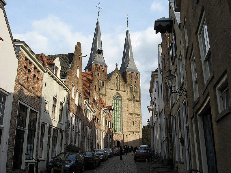
Deventer, Nederland
Probably at the end of the 13th century, Deventer joined the Hanseatic League. At the height of the Hanseatic League in the mid-15th century, a large network of regular trade contacts existed from the Baltic States to England and from Norway deep into Austria .
The city was a port city. Large ships could navigate the IJssel inland as far as Deventer and moor at the quay. The Schipbeek was made navigable for small river ships as far as Münsterland by order of the city. It used to flow into the IJssel on the south side of the city and formed a natural harbor there. Overseas trade contacts existed in particular with Norwegian Bergen, for stockfish, and with Skåne (pronounced "Skoone"), now southern Sweden, but at that time Danish, where herring came from. That is why Deventer people used to be called stockfish or Schoonevaarders. There was also a lot of trade with the German Rhineland, the names "De Wezel" and "die Köln" in the facade of the Assenstraat 10 building are still reminders of this. Until the end of the Middle Ages in the area that is now the Netherlands, the city was a prominent trading city with German imperial privileges, such as the minting of gold coins.
In 1334 the city was hit by a major city fire.
In 1456 the Overstichtse Hanseatic cities resisted the candidate for the bishop's see of Utrecht proposed by the Burgundians. The Burgundian dukes, and their representatives/relatives, advocated a more centralized policy in which the cities could assert their privileges less. The Duke of Burgundy, Philip the Good marched from Utrecht to Deventer with an army. After a short siege, the duke was able to impose his will on the city, and with it on the other Oversticht cities. It was the beginning of the decline of the power of the Hanseatic League in the northern Netherlands. From 1495, the city was still allowed to call itself a 'free imperial city', just like Zwolle and Kampen. The administrators of Deventer saw reason to adorn the city coat of arms with the German eagle and the imperial crown.
The city reached its economic peak at the end of the 15th century. At that time, five large markets were held every year, each lasting weeks and for which there was interest far beyond the Netherlands. Deventer was a center for internationally active merchants. At the beginning of the 16th century, the economic center of gravity in the northern Netherlands would shift definitively to the cities in Holland and Zeeland.
Audio tour Hanseatic city of Deventer. https://izi.travel/nl/a3f4-audiotour-hanzestad-deventer-3-4-km-ijsselroute-hanzetour-com/nl
Source: Wikipedia
52° 15' 11.6" N 6° 9' 30.5" E
52.2532272 6.1584725
• Head northeast on Vleeshouwerstraat.
• Turn right onto Kleine Overstraat. Go for 174 m.
• Turn right onto Brink. Go for 70 m.
• Turn left onto Boterstraat. Go for 38 m.
• Turn right onto Zandpoort. Go for 132 m.
• Turn left onto Welle. Go for 34 m.
• Continue on Pothoofd. Go for 774 m.
• Turn right onto Meester H.F. de Boerlaan. Go for 108 m.
• Continue on Zutphenseweg. Go for 554 m.
• Turn right onto Zutphenseweg. Go for 821 m.
• Take ramp onto A1 toward Apeldoorn/Amsterdam. Go for 9.3 km.
• Take exit 21 toward Arnhem onto A50. Go for 23.4 km.
• Take exit 20 toward Arnhem-Centrum onto N784 (Apeldoornseweg). Go for 4.9 km.
• Keep left onto Apeldoornseweg. Go for 398 m.
• Continue on Apeldoornsestraat. Go for 161 m.
• Turn right onto Jansbuitensingel. Go for 61 m.
• Arrive at Jansbuitensingel. Your destination is on the left.
☍
40,9 km
( 29 min.)
Arnhem, Nederland
The history of Arnhem is old and eventful. In the ninth century there was a church on that site, which belonged to the St. Salvatore abbey in Prüm (Germany). Three centuries later, the Count of Gelre levied tolls and Arnhem received city rights. For some time Arnhem was a member of the Hanze. Arnhem became an important city in the sixteenth century in particular, after Emperor Charles V designated the city as the de facto capital and government center of Gelderland.
Walk with audio support. https://izi.travel/nl/545a-arnhem-back-to-toen/nl
Source: https://www.absolutefacts.nl/historie/data/history-arnhem.htm
Photo source: Gelders archive
51° 59' 3.3" N 5° 54' 39.1" E
51.9842570 5.9108573
• Head west on Jansbuitensingel. Go for 336 m.
• Keep left onto Willemsplein toward Arnhem-Zuid/Nijmegen. Go for 150 m.
• Continue on Willemstunnel. Go for 251 m.
• Continue on Nieuwe Plein. Go for 79 m.
• Keep right onto Nieuwe Plein. Go for 26 m.
• Continue on Roermondsplein. Go for 2.4 km.
• Turn left onto Batavierenweg toward GelreDome/Rijnhal/Nijmegen/Zutphen/Oberhausen/P+R/N325. Go for 450 m.
• Keep right onto Batavierenweg. Go for 120 m.
• Keep right toward Nijmegen. Go for 69 m.
• Continue on Nijmeegseweg (A325). Go for 6.8 km.
• Take the exit toward Eindhoven/Venlo/Tiel/Rotterdam onto A15. Go for 7.3 km.
• Take the exit toward Venlo/Eindhoven/E31 onto A50. Go for 14.1 km.
• Take the exit toward Nijmegen/Wijchen onto A326. Go for 1.6 km.
• Take the exit toward Bergharen/Wijchen/Niftrik. Go for 331 m.
• Turn right onto Hernenseweg. Go for 285 m.
• Take the 2nd exit from roundabout onto N845. Go for 1.2 km.
• Pass 3 roundabouts and continue on Drutenseweg (N845). Go for 4.1 km.
• Turn right onto Graafseweg (N324). Go for 2.1 km.
• Take the 1st exit from roundabout onto Arnoud van Gelderweg (N324). Go for 771 m.
• Turn left onto Sint Elisabethstraat (N321). Go for 425 m.
• Turn left onto Brugstraat. Go for 133 m.
• Turn right onto Rogstraat. Go for 119 m.
• Turn left onto Markt. Go for 17 m.
• Arrive at Markt. Your destination is on the right.
☍
43,1 km
( 32 min.)
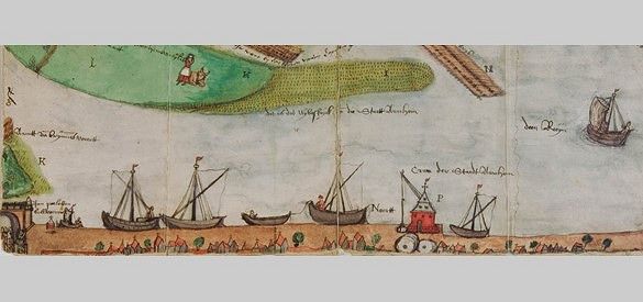
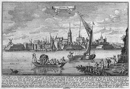
Grave, Nederland
Source photo British Library
Grave, Land van Cuijk, Nederland
51° 45' 34.7" N 5° 44' 28" E
51.7596504 5.7411125
• Head toward Hoofdwagt on Markt. Go for 40 m.
• Turn left onto Scheerestraat. Go for 108 m.
• Turn left onto Klinkerstraat. Go for 36 m.
• Turn right onto Hamstraat. Go for 176 m.
• Turn right onto Sint Elisabethstraat (N321). Go for 170 m.
• Turn left onto Elftweg (N324). Go for 1.0 km.
• Pass 3 roundabouts and continue on Bosschebaan (N324). Go for 4.3 km.
• Keep right toward Bosschebaan/N324. Go for 51 m.
• Pass 2 roundabouts and continue on Bosschebaan (N324). Go for 6.9 km.
• Turn right onto Graafsebaan (N329) toward Oss/'s-Hertogenbosch/A59. Go for 379 m.
• Take ramp onto A59 (Knooppunt Paalgraven) toward Heesch-West/'s-Hertogenbosch. Go for 16.6 km.
• Take the left exit toward Ring-Zuid/Eindhoven/Tilburg onto A2 (Ring 's-Hertogenbosch). Go for 3.3 km.
• Take exit 22 toward St. Michielsgestel/Schijndel. Go for 454 m.
• Turn right onto Gestelseweg (N617) toward Industrieterrein 8000-9000/Transferium. Go for 798 m.
• Take the 2nd exit from roundabout onto Gestelseweg. Go for 395 m.
• Continue on Van Veldekekade. Go for 134 m.
• Turn right onto Van Veldekekade. Go for 613 m.
• Continue on Zuid Willemsvaart. Go for 715 m.
• Take the 1st exit from roundabout onto Zuid Willemsvaart. Go for 177 m.
• Turn left onto Tolbrugstraat. Go for 185 m.
• Continue on Burgemeester Loeffplein. Go for 147 m.
• Turn right onto Burgemeester Loeffplein. Go for 43 m.
• Turn right onto Burgemeester Loeffplein. Go for 99 m.
• Arrive at Burgemeester Loeffplein.
☍
36,9 km
( 32 min.)
's-Hertogenbosch, Nederland
The history of Den Bosch, we go far back in time from the origins of 's-Hertogenbosch. From Hertog Hendrik van Brabant to the Protestant Frederik Hendrik, the invasion of the French and the Second World War. Even though the history of Den Bosch was already dominated by culture around the 13th century, they have all made a positive and/or negative contribution to the growth of the city of 's-Hertogenbosch. Nowadays, 's-Hertogenbosch is known as the capital of Brabant with a rich culture that the people of Den Bosch are proud of. City walk with audio support. https://izi.travel/nl/987a-puur-s-hertogenbosch/nl
Between Helvoirt and Haaren an actual part of the Vlamenschenstraat was preserved. As the name Antwerpse Baan tells us, this is a remnant of the old, medieval trade route between 's-Hertogenbosch and Antwerp. At the time, merchants preferred transport by water, but there was no suitable shipping route from Den Bosch in a southwesterly direction. The freight carts to Antwerp drove from the Vughterpoort on dirt roads to Helvoirt, Tilburg, Turnhout and beyond.
Source: https://www.denbosch-cultuurstad.nl/Category/Geschiedenis_van_Den_Bosch
Photo source: Detail from Ludovico Guicciardini: Omnium Belgi Sive Inferioris Germaniae. Arnhem, Johannes Jansz, 1616
51° 41' 20.2" N 5° 18' 11.2" E
51.6889351 5.3031044
• Head northwest on Burgemeester Loeffplein.
• Continue on Achter de Tolbrug. Go for 29 m.
• Turn right onto Burgemeester Loeffplein. Go for 96 m.
• Turn right onto Pastoor de Kroonstraat. Go for 9 m.
• Continue on Tolbrugstraat. Go for 19 m.
• Turn slightly left onto Tolbrugstraat. Go for 185 m.
• Turn left onto Zuid Willemsvaart. Go for 191 m.
• Turn right onto Citadellaan. Go for 602 m.
• Turn right onto Orthenseweg. Go for 654 m.
• Continue on Orthen. Go for 403 m.
• Continue on Hambakenweg. Go for 1.2 km.
• Continue on Maaspoortweg. Go for 194 m.
• Turn left and take ramp onto A59 (Ring 's-Hertogenbosch) toward Waalwijk/Zierikzee. Go for 18.3 km.
• Take exit 37 toward Waalwijk/Sprang-Capelle/Tilburg onto N261 (Midden-Brabantweg). Go for 13.7 km.
• Turn right onto Zevenheuvelenweg toward Industrieterrein 0-2000/Industrieterrein 3000-4000. Go for 140 m.
• Turn right onto Kraaivenstraat. Go for 173 m.
• Arrive at Kraaivenstraat. Your destination is on the right.
☍
35,8 km
( 26 min.)
Tilburg, Nederland
City walk with audio support. https://izi.travel/nl/57ac-04-city walk-tilburg-around-heuvel-old-market/nl
Picture source: Wikipedia
51° 35' 8.2" N 5° 3' 57.8" E
51.5856188 5.0660619
• Head south on Kraaivenstraat. Go for 173 m.
• Turn left onto Zevenheuvelenweg. Go for 140 m.
• Turn right onto Midden-Brabantweg toward Centrum/Industrieterrein 5000-6000/Industrieterrein 8000-9000. Go for 884 m.
• Take the 2nd exit from Hasseltrotonde roundabout onto Ringbaan West toward Turnhout/Centrum/Universiteit/Industrieterrein 8000-9000/Eindhoven. Go for 1.7 km.
• Continue on Ringbaan West toward Universiteit/Industrieterrein 8000-9000/Eindhoven/'s-Hertogenbosch/Turnhout/Breda/Goirle. Go for 1.8 km.
• Take ramp onto Blaakweg (N630) toward Industrieterrein 8000-8600/Breda/Eindhoven/'s-Hertogenbosch/Goirle/Turnhout. Go for 690 m.
• Turn right and take ramp onto A58 toward Breda. Go for 21.9 km.
• Take the left exit toward E19/Antwerpen onto A16. Go for 5.9 km.
• Continue on E19. Go for 10.3 km.
• Take exit 2 toward Hoogstraten. Go for 1.0 km.
• Continue on Hoogstraatseweg (N144). Go for 3.0 km.
• Take the 2nd exit from roundabout onto Loenhoutseweg (N144). Go for 370 m.
• Turn right onto Loenhoutseweg. Go for 260 m.
• Turn left onto Putten. Go for 777 m.
• Turn left onto Kleistraat. Go for 88 m.
• Turn slightly left onto Kleistraat. Go for 166 m.
• Turn right onto Kruisblok. Go for 42 m.
• Arrive at Kruisblok. Your destination is on the left.
☍
49,2 km
( 38 min.)
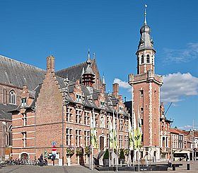
Hoogstraten, België
Photo: Hoogstraten town hall
Source: Wikipedia
Hoogstraten, 2320, Hoogstraten, België
51° 23' 44.6" N 4° 44' 38.7" E
51.3957302 4.7440872
• Head west on Kruisblok. Go for 42 m.
• Turn left onto Kleistraat. Go for 254 m.
• Turn right onto Putten. Go for 777 m.
• Turn right onto Loenhoutseweg. Go for 260 m.
• Turn left onto Loenhoutseweg (N144). Go for 301 m.
• Take the 2nd exit from roundabout onto Loenhoutseweg (N144). Go for 3.1 km.
• Turn left and take ramp onto E19 toward Antwerpen. Go for 23.6 km.
• Take the exit toward Ring 2/Brugge/Bergen op Zoom/Haven/Centrum Noord onto A12 (Antwerpen-Noord). Go for 2.1 km.
• Take exit 16 toward Centrum Noord/Haven 1-490/Ekeren/Haven 1-100 onto N180 (Noorderlaan). Go for 3.9 km.
• Turn right onto Groenendaallaan (N101). Go for 421 m.
• Continue on N101. Go for 60 m.
• Continue on Straatsburgbrug (N101). Go for 715 m.
• Continue on Siberiastraat (N101). Go for 522 m.
• Continue on Oosterweelsteenweg (N101). Go for 144 m.
• Keep left onto Oosterweelsteenweg (N101). Go for 80 m.
• Continue on Sluisstraat. Go for 237 m.
• Continue on Kattendijkbrug. Go for 225 m.
• Continue on Rijnkaai. Go for 479 m.
• Continue on Zeeuwsekoornmarkt. Go for 347 m.
• Continue on Van Meterenkaai. Go for 93 m.
• Continue on Orteliuskaai. Go for 116 m.
• Continue on Jordaenskaai. Go for 213 m.
• Turn left onto Zakstraat. Go for 95 m.
• Continue on Zirkstraat. Go for 115 m.
• Turn right onto Hofstraat. Go for 118 m.
• Arrive at Hofstraat.
☍
38,4 km
( 33 min.)
Antwerpen, België
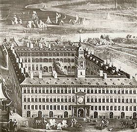
In the fifteenth century, the German Hanseatic League already owned two city buildings in Antwerp, but they quickly proved too small.
After difficult negotiations between the Hanseatic League and the city council, both decided shortly after the middle of the sixteenth century to build the Hansa House. The architect Cornelis Floris De Vriendt was appointed for this purpose. The result was a building in late Renaissance palazzo style with a rectangular floor plan of 80 by 62 meters and three storeys. The basement and ground floors were arranged as warehouses, while the upper floors functioned as work and living spaces for the merchants.
After the fall of Antwerp in 1585, the city lost its function as a trading metropolis. The Hansahuis no longer functioned as a trading palace, but successively became a warehouse, barracks, military hospital and Protestant church. Until 1863 the building remained the property of the Hanseatic cities, after which it was transferred to the Belgian state. In 1893 the Hansahuis was destroyed by a fire.
City walk with audio support. https://izi.travel/nl/1955-antwerpen/nl
Photo: Hansa House
Source: https://www.antwerpendoorgrond.be/nl/verforte_stad/info/de_hanze_in_antwerpen#:~:text=Eigenlijk%20is%20Antwerp%20never%20een,het%20Hansahuis%20in%20de%20Nieuwstad.
Photo source: www.felixarchief.be,
51° 13' 16" N 4° 23' 58.9" E
51.2211097 4.3997081
• Head southwest on Hofstraat.
• Turn right onto Oude Beurs. Go for 60 m.
• Turn right onto Lange Doornikstraat. Go for 110 m.
• Turn right onto Zirkstraat. Go for 146 m.
• Turn right onto Lange Koepoortstraat. Go for 129 m.
• Continue on Korte Koepoortstraat. Go for 50 m.
• Continue on Melkmarkt. Go for 44 m.
• Continue on Korte Nieuwstraat. Go for 197 m.
• Turn right onto Sint-Katelijnevest. Go for 182 m.
• Turn left onto Meir. Go for 29 m.
• Continue on Huidevettersstraat. Go for 253 m.
• Continue on Lange Gasthuisstraat. Go for 8 m.
• Keep left onto Lange Gasthuisstraat. Go for 157 m.
• Keep right onto Lange Gasthuisstraat. Go for 168 m.
• Continue on Mechelseplein. Go for 38 m.
• Continue on Sint-Jorispoort. Go for 154 m.
• Continue on Leopoldplaats. Go for 45 m.
• Continue on Mechelsesteenweg. Go for 95 m.
• Turn right onto Britselei (N113). Go for 1.7 km.
• Take the exit toward Ring Antwerpen 1/Brugge/Gent onto E34 (Ring Antwerpen 1). Go for 2.7 km.
• Take the exit onto E34 (Ring Antwerpen 1). Go for 54.8 km.
• Turn left onto Vaartstraat (N456) toward Evergem/Lembeke. Go for 862 m.
• Turn right onto Vrombautstraat. Go for 4.1 km.
• Take the 2nd exit from roundabout onto Blommekens (N434). Go for 1.0 km.
• Turn left onto Markt (N9). Go for 251 m.
• Turn left onto Markt. Go for 81 m.
• Turn left onto Kerkplein. Go for 34 m.
• Arrive at Kerkplein. Your destination is on the left.
☍
67,5 km
( 52 min.)
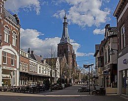
Eeklo, België
City walk with audio support. https://izi.travel/nl/2983-fast-4-ward-eeklo-az-alma-6-3km/nl
Photo town hall Eeklo
Source: Wikipedia
Eeklo, 9900, België
51° 11' 4.1" N 3° 33' 59.7" E
51.1844827 3.5665965
• Head west on Kerkplein. Go for 50 m.
• Turn left onto Kerkplein. Go for 35 m.
• Turn right onto Markt (N9) toward E34/Brugge/Maldegem/Industriezone Eeklo. Go for 8.7 km.
• Take the 2nd exit from roundabout onto Koningin Astridlaan (N9) toward Brugge. Go for 1.8 km.
• Take the 4th exit from roundabout onto Brugse Steenweg (N9) toward Brugge. Go for 8.2 km.
• Take the 2nd exit from roundabout onto Bruggesteenweg (N9). Go for 5.1 km.
• Keep right onto Maalse Steenweg. Go for 86 m.
• Keep left toward Moerkerkse Steenweg. Go for 42 m.
• Turn left onto Moerkerkse Steenweg. Go for 30 m.
• Continue on Langestraat. Go for 786 m.
• Continue on Hoogstraat (N9). Go for 282 m.
• Continue on Hoogstraat. Go for 55 m.
• Arrive at Hoogstraat. Your destination is on the left.
☍
25,2 km
( 35 min.)
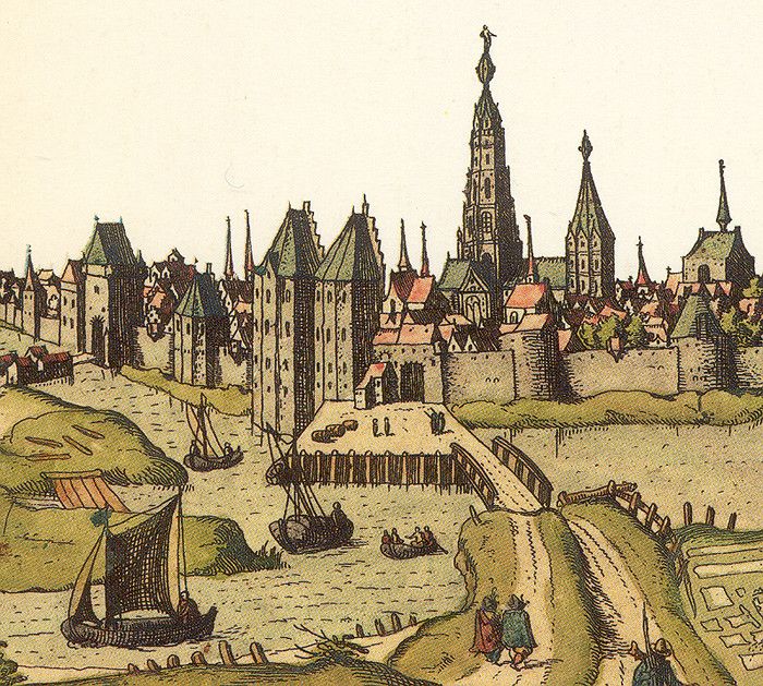
Brugge, België
Wir sind ein Handellreibend Volk, mein König.
Was köstlich wächst in allen Himmelsstrichen.
Wird ausgestellt zur Schau und zum Genuss
Auf unerm Markt zu Bruegg.
(Schalfer. Die Jungfrau von Orleans. Third Act, Third Scene).
It was mainly in the period from the middle of the thirteenth to the end of the fourteenth century that Bruges developed into the great trading metropolis of Northwest Europe. An extremely favorable location from a mercantile point of view and the highly sought-after products of an industry famous throughout Europe had created the foundations for the flourishing of a truly international commercial life.
The street names of Bruges already prove to us that the Flemish Emporium displayed a cosmopolitan aspect like no other city north of the Alps. Since the end of the thirteenth and the beginning of the fourteenth century, Bruges had streets named after the citizens of Lübeck (since 1282), of Hamburg (since 1306).
City walk with audio support. https://izi.travel/nl/3ac0-discover-the-center-of-bruges/en
Photo: Hanzekantoor Bruges
Source photo Wikipedia
51° 12' 30.8" N 3° 13' 36.4" E
51.2085526 3.2267720