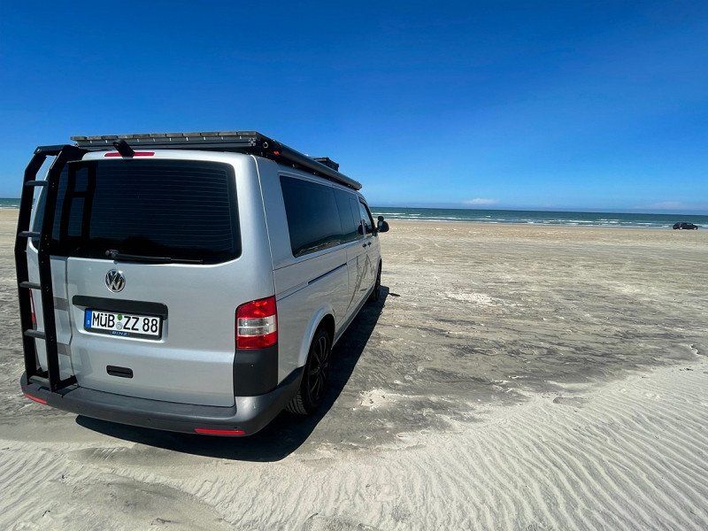
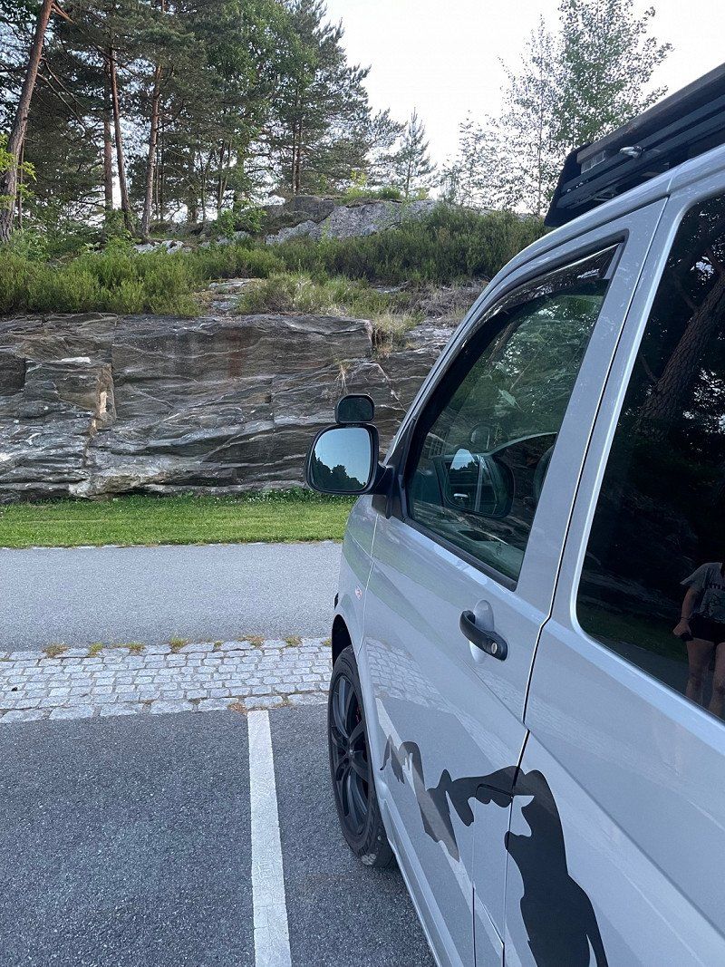
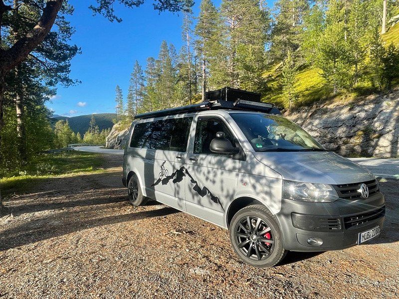
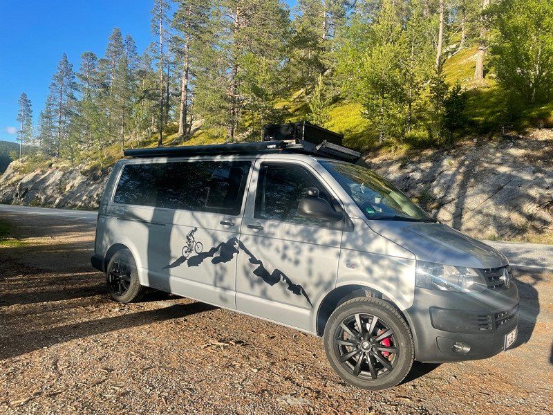
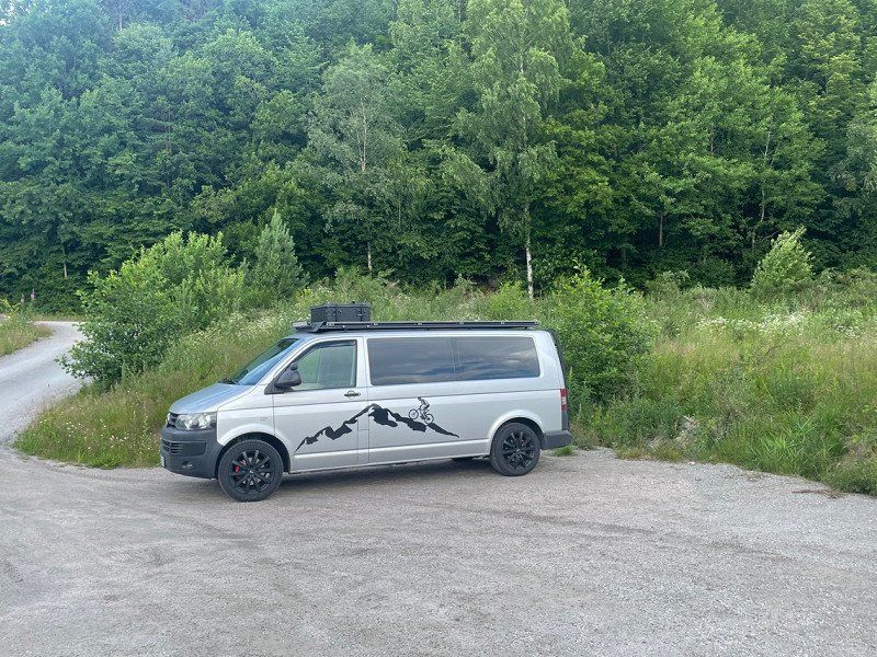
We travel to Norway for 3.5 weeks from mid-June to mid-July with our self-built T5 camper and then spend a few nice days in Denmark.
Route is of course still in progress until July 11th, 2022.
Day
Hof, Deutschland
50° 18' 48.7" N 11° 54' 46" E
50.3135391 11.9127814
• Head toward Marienstraße on Bachstraße. Go for 45 m.
• Turn left onto Marienstraße. Go for 220 m.
• Continue on Hans-Böckler-Straße. Go for 70 m.
• Turn right onto Ossecker Straße. Go for 301 m.
• Turn right onto Ernst-Reuter-Straße (B2/B15). Go for 629 m.
• Continue on Ernst-Reuter-Straße (B173) toward Dresden/A72/B15/Kronach/Coburg/B2/Schleiz/Plauen/Freiheitshalle. Go for 1.3 km.
• Keep left onto Ernst-Reuter-Straße (B173) toward Berlin/A9/Dresden/A72/Coburg/Kronach/Naila. Go for 5.6 km.
• Turn right onto St2692 toward Berg. Go for 4.0 km.
• Turn left and take ramp onto A9 toward Berlin. Go for 132 km.
• Take exit 15 toward Magdeburg/Halle onto A14. Go for 108 km.
• Take exit 2 toward Hannover/Braunschweig onto A2. Go for 119 km.
• Take exit 48 toward Hamburg/Bremen onto A7. Go for 147 km.
• Keep right onto A7. Go for 159 km.
• Continue on E45 (Sønderjyske Motorvej). Go for 89.5 km.
• Keep left onto E45 (Kolding) toward Århus/Vejle. Go for 205 km.
• Keep right onto E39 (Vendsyssel) toward Hirtshals/Hjørring/Brønderslev/Høvejen/Thisted. Go for 57.6 km.
• Take the 2nd exit from roundabout onto Aalborgvej (E39) toward Hirtshals. Go for 2.3 km.
• Take the 3rd exit from roundabout onto Dalsagervej (55) toward Tornby/Hirtshals S. Go for 184 m.
• Turn right onto Søndergade toward Hirtshals C. Go for 1.0 km.
• Take the 1st exit from roundabout onto Margrethevej. Go for 774 m.
• Turn right onto Lillehedenvej. Go for 93 m.
• Arrive at Lillehedenvej. Your destination is on the right.
☍
1,033,8 km
(9 hrs. 17 min.)
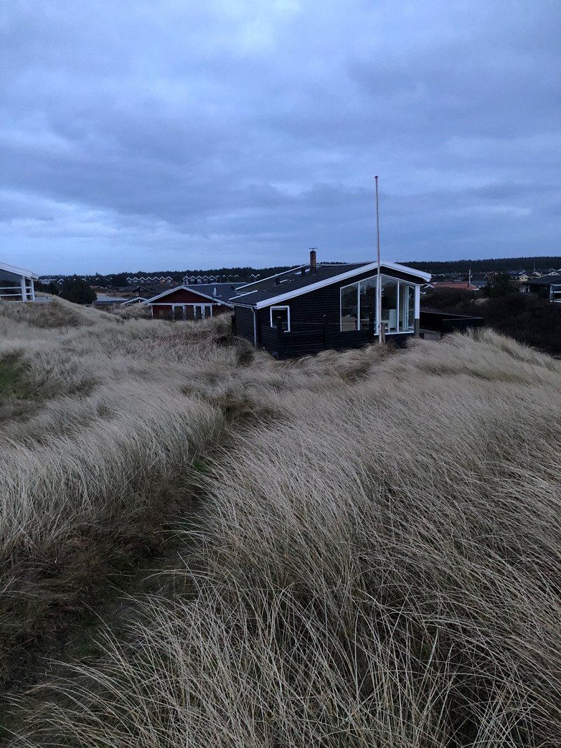
Hirtshals, Dänemark
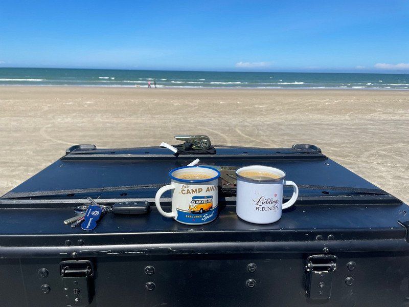
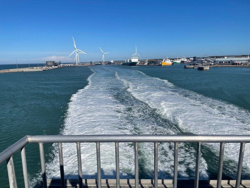
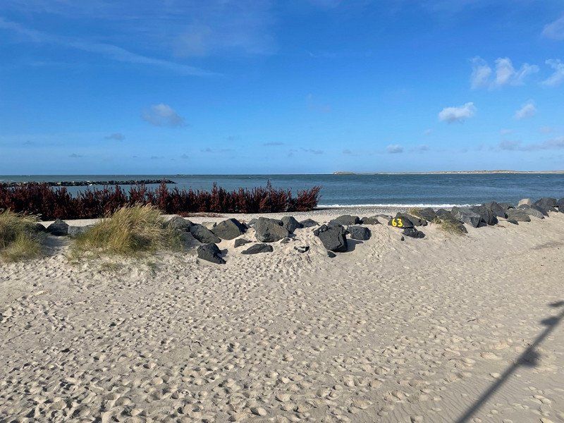
Completely drove through Denmark and off to the ferry to Kristiansand.
The ferry is a very cheap and relaxed alternative to the Oresund Bridge.
We actually wanted to go to Oslo via Sweden, but we still decided to take the ferry due to lack of time.
9850 Hirtshals, Dänemark
57° 35' 13" N 9° 58' 0.6" E
57.5869530 9.9668379
• Head toward Damsvej on Lillehedenvej. Go for 268 m.
• Turn left onto Skovvejen. Go for 61 m.
• Take the 1st exit from roundabout onto Østergade. Go for 511 m.
• Turn right onto Willemoesvej. Go for 153 m.
• Turn right onto Aalborgvej (E39) toward Hirtshals/Color Line. Go for 274 m.
• Keep left onto E39 toward Color Line/Check-in. Go for 783 m.
• Take the Hirtshals-Kristiansand Ferry. Stay on for 139 km.
• Head northwest. Go for 606 m.
• Take the 1st exit from roundabout onto Vesterveien toward Oslo/E18/Evje/9/Sentrum. Go for 361 m.
• Take the 2nd exit from roundabout onto E18 toward Oslo. Go for 2.5 km.
• Take ramp toward Lund Ø/Gimle. Go for 192 m.
• Enter the roundabout. Go for 58 m.
• Arrive at your destination on the right.
☍
144,7 km
(4 hrs. 9 min.)
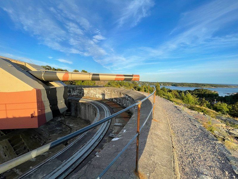
Kristiansand, Norwegen
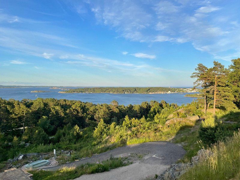
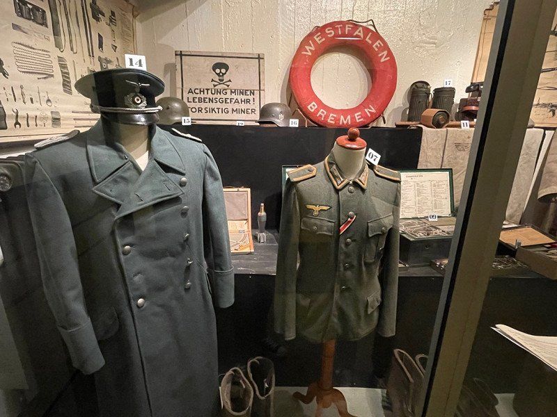
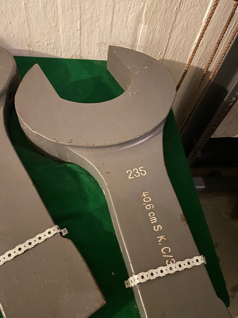
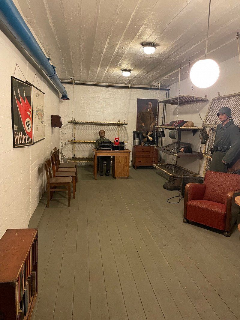
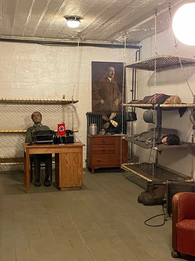
Arrived in Kristiansand after about 2.5 hours by ferry, we went to the Cannon Museum.
A wonderful piece of history. You walk through the whole area without a companion and can take as much time as you want if you want.
58° 9' 35.7" N 8° 1' 5.5" E
58.1599119 8.0182064
• Follow the roundabout. Go for 27 m.
• Take the 2nd exit from roundabout onto E18 toward Oslo. Go for 24.6 km.
• Take exit 85 toward Birkeland/Møglestu. Go for 206 m.
• Take the 1st exit from roundabout onto Birkelandsveien (402). Go for 246 m.
• Pass 2 roundabouts and continue on Birkelandsveien (402). Go for 10.3 km.
• Turn right onto 41. Go for 34.1 km.
• Turn left toward Evje/Åmli. Go for 23 m.
• Continue on Telemarksveien (41/42) toward Evje/Åmli. Go for 2.6 km.
• Turn right onto Telemarksveien (41) toward Åmli. Go for 12.2 km.
• Turn right onto Dølemo (41) toward Åmli. Go for 45.2 km.
• Arrive at Treungvegen (41). Your destination is on the right.
☍
129,6 km
(2 hrs. 1 min.)
Treungen, Norwegen
From Kristiansand in the direction of Oslo we stopped at a cozy place to sleep, which spontaneously appealed to us.
59° 1' 14.3" N 8° 31' 12.7" E
59.0206471 8.5202070
• Head southeast on Treungvegen (41). Go for 313 m.
• Turn left onto Skålestronda (358) toward Drangedal. Go for 28.2 km.
• Turn right onto Tørdalsveien (38). Go for 12.5 km.
• Take the 2nd exit from roundabout onto Drangedalsveien (38). Go for 7.9 km.
• Turn right onto Drangedalsveien (38). Go for 22.0 km.
• Turn left toward Oslo/Farsjø. Go for 116 m.
• Continue on Farsjøveien. Go for 15 m.
• Take ramp onto E18. Go for 30.2 km.
• Take ramp toward Heistad. Go for 189 m.
• Take the 2nd exit from roundabout. Go for 379 m.
• Take the 1st exit from roundabout onto E18. Go for 13.0 km.
• Turn right. Go for 621 m.
• Continue toward E18. Go for 38 m.
• Take the 2nd exit from roundabout onto E18 toward Oslo. Go for 144 km.
• Take ramp toward DFDS/Stena/Sentralst. Go for 531 m.
• Turn right onto Myntgata toward Ring 1. Go for 66 m.
• Turn left onto Langkaia toward Ring 1. Go for 183 m.
• Continue on Langkaia. Go for 133 m.
• Turn right onto Operagata toward Ring 1. Go for 316 m.
• Turn left onto Nylandsveien. Go for 514 m.
• Take the 3rd exit from roundabout toward Sentrum V. Go for 205 m.
• Take the 1st exit from roundabout onto Schweigaards gate (162) toward Ring 1/Sentrum V. Go for 105 m.
• Take the 2nd exit from roundabout onto Lybekkergata (162). Go for 214 m.
• Arrive at Lybekkergata (162). Your destination is on the left.
☍
261,7 km
(3 hrs. 18 min.)
Day
Oslo, Norwegen
59° 54' 49.9" N 10° 45' 8.1" E
59.9138688 10.7522454
• Head toward Stenersgata on Lybekkergata (162). Go for 192 m.
• Take the 2nd exit from roundabout onto Schweigaards gate (162). Go for 145 m.
• Take the 1st exit from roundabout onto Schweigaards gate (162) toward Ring 1/Sentrum Ø/E18/Stokholm/E6. Go for 136 m.
• Turn right onto 162 toward Ring 1/Sentrum Ø/E18/E6/Stockholm. Go for 61 m.
• Take the 1st exit from roundabout onto 162. Go for 1.1 km.
• Keep left onto 162 toward Ekeberg/E6/Trondheim/E18/Gøteborg/Stokholm. Go for 263 m.
• Take the 2nd exit from roundabout onto Operatunnelen (190) toward E6/Trondheim. Go for 3.0 km.
• Keep left onto Strømsveien (190) toward E6/Trondheim/Gardermoen Lufthavn/Ring 3/4/Sinsen/163/Stovner. Go for 2.5 km.
• Continue on E6. Go for 35.8 km.
• Continue on E6 toward Trondheim. Go for 11.9 km.
• Take exit 54 toward Hønefoss/E16/Nannestad/Råholt/Ørn Industriområde. Go for 203 m.
• Take the 3rd exit from roundabout onto Kolonivegen (176) toward Hønefoss/35/Nannestad. Go for 1.1 km.
• Take the 1st exit from roundabout onto Sessvollvegen (176). Go for 4.3 km.
• Take the 1st exit from roundabout onto Vestre Hurdalsveg (120). Go for 12.2 km.
• Turn right onto Grensevegen. Go for 355 m.
• Turn right onto Grensevegen. Go for 299 m.
• Turn slightly left onto Grensevegen. Go for 69 m.
• Arrive at Grensevegen.
☍
73,6 km
( 58 min.)
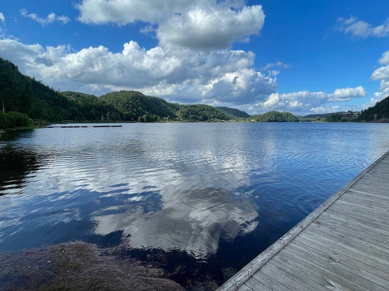
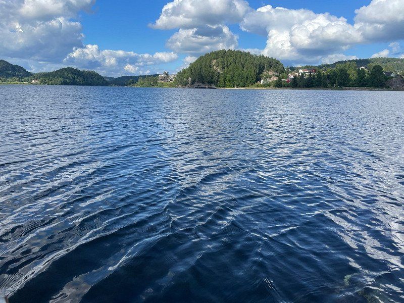
Hurdalssjøen, Norwegen
60° 20' 52.9" N 11° 2' 25.1" E
60.3480261 11.0403032
• Head west on Grensevegen. Go for 368 m.
• Turn left onto Grensevegen. Go for 355 m.
• Turn left onto Vestsidevegen (120). Go for 12.2 km.
• Take the 3rd exit from roundabout onto Sessvollvegen (176). Go for 4.3 km.
• Take the 2nd exit from roundabout onto Kolonivegen (176). Go for 976 m.
• Take the 3rd exit from roundabout onto E6 toward Trondheim. Go for 101 km.
• Take the 1st exit from roundabout onto Lillehammervegen (E6) toward Trondheim/Lillehammer. Go for 15.8 km.
• Turn left onto Biristrandvegen (2538). Go for 77 m.
• Turn right onto Biristrandvegen (2538). Go for 596 m.
• Continue on Paul A. Owrens veg (2538). Go for 2.4 km.
• Turn left onto Moabakken. Go for 112 m.
• Arrive at Moabakken. Your destination is on the right.
☍
137,7 km
(1 hrs. 34 min.)
Vingrom, Norwegen
61° 2' 39.6" N 10° 25' 42.5" E
61.0443405 10.4284798
• Head northeast on Moabakken. Go for 112 m.
• Turn left onto Paul A. Owrens veg (2538). Go for 155 m.
• Turn right onto Paul A. Owrens veg (250). Go for 290 m.
• Take the 1st exit from roundabout onto E6. Go for 3.1 km.
• Take the 1st exit from roundabout onto E6. Go for 115 km.
• Turn right. Go for 583 m.
• Continue straight ahead. Go for 3.1 km.
• Keep right. Go for 2.1 km.
• Keep right toward Mysusetervegen. Go for 840 m.
• Continue on Mysusetervegen. Go for 757 m.
• Turn slightly left onto 2628. Go for 30 m.
• Continue on Rondanevegen (2628). Go for 614 m.
• Continue on 2628. Go for 84 m.
• Turn left onto Tjønnbakkvegen. Go for 254 m.
• Turn slightly left onto Tjønnbakkvegen. Go for 67 m.
• Turn right. Go for 21 m.
• Arrive at your destination on the left.
☍
127,2 km
(1 hrs. 53 min.)
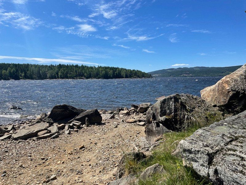
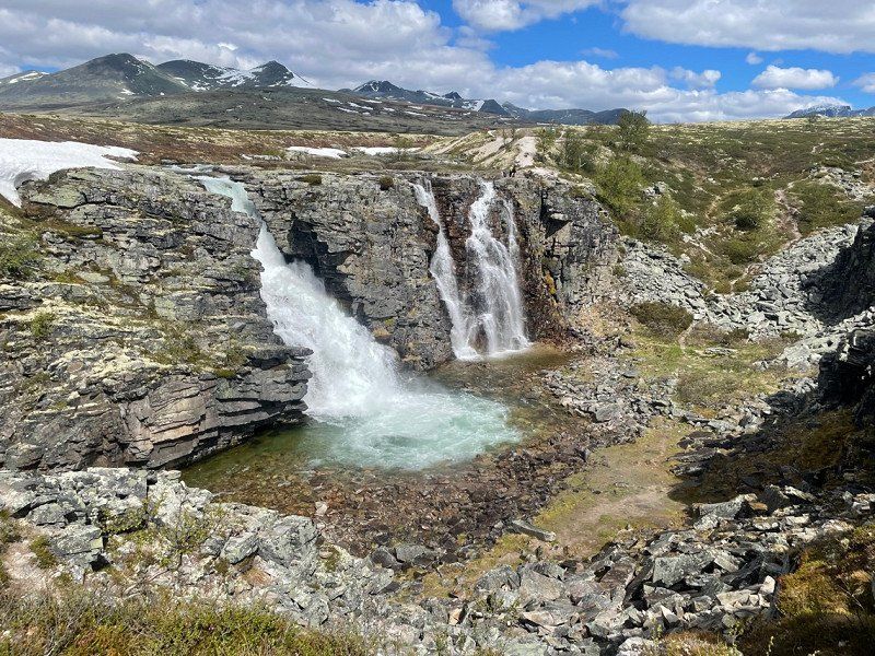
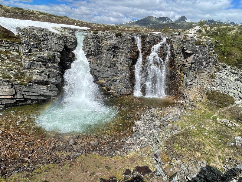
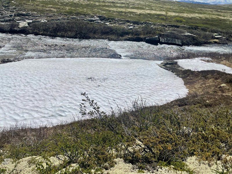
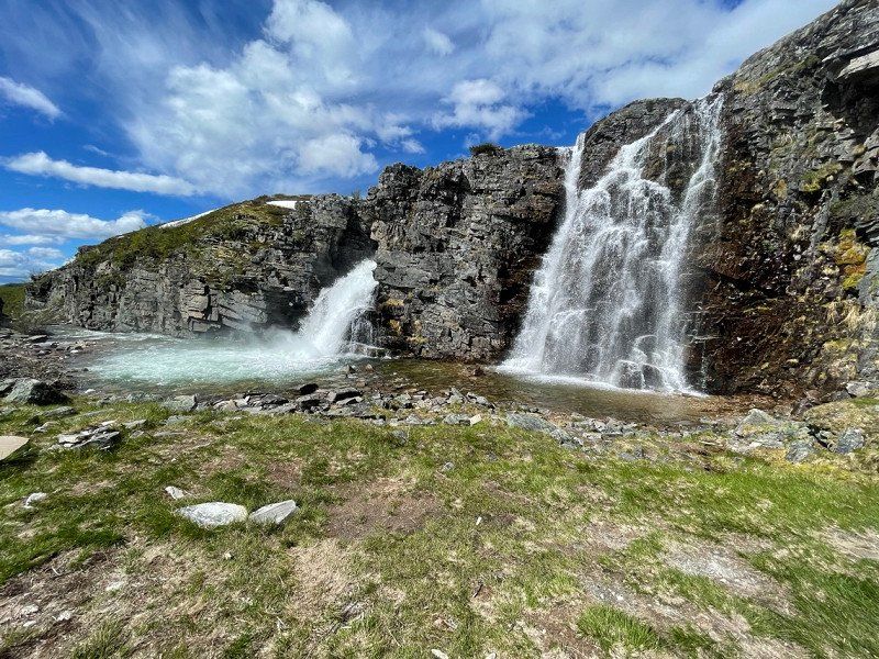
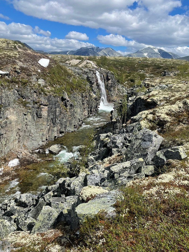
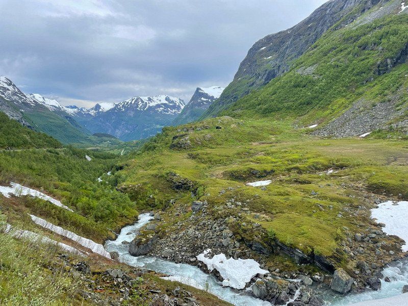
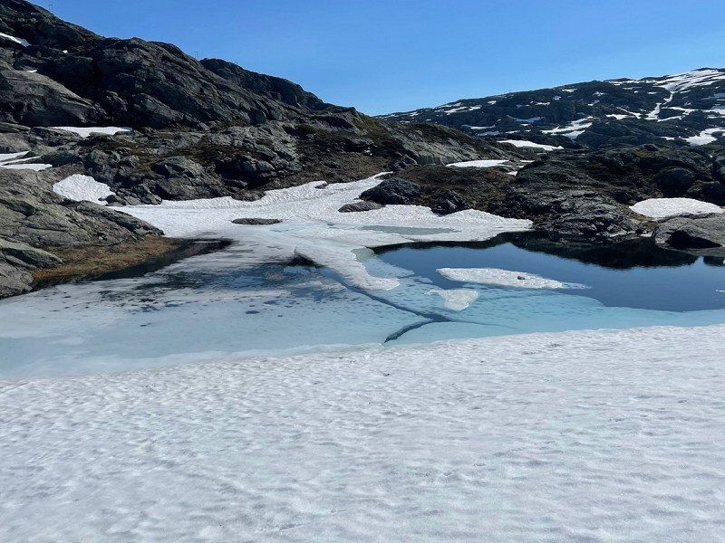
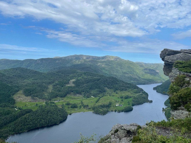
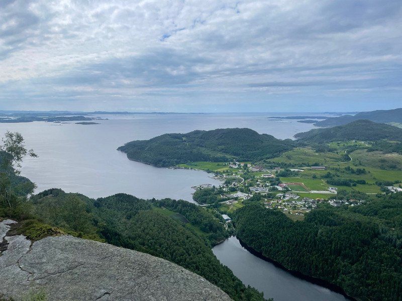
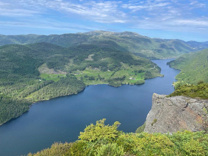
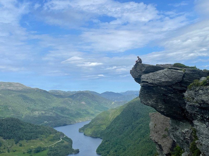
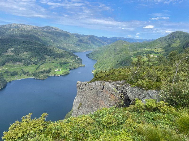
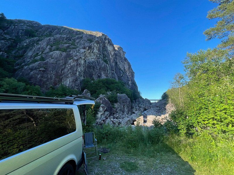
Mysusæter, Norwegen
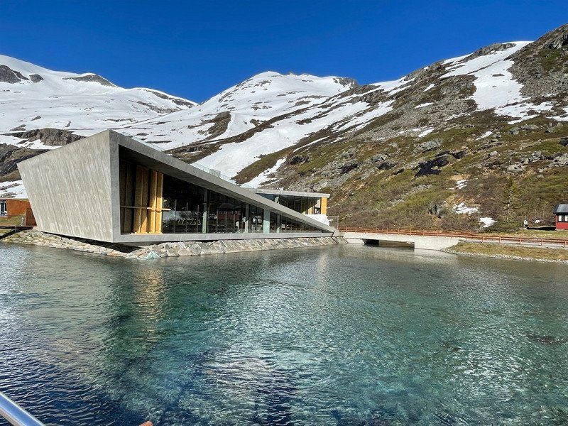
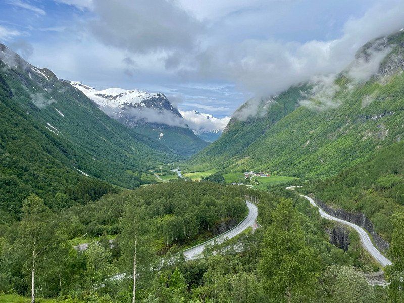
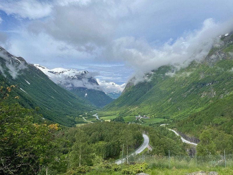
From the second parking space we quickly drove to the Rondane National Park and did our first major hike of 24 km
The national park is so huge, you could hike here for several days and I think you will always find something new that is fantastic.
61° 48' 36.7" N 9° 41' 15.7" E
61.8101884 9.6876916
• Head toward Tjønnbakkvegen. Go for 21 m.
• Turn left onto Tjønnbakkvegen. Go for 321 m.
• Turn right onto 2628. Go for 84 m.
• Continue on Rondanevegen (2628). Go for 614 m.
• Continue on 2628. Go for 30 m.
• Turn slightly right onto Mysusetervegen. Go for 7.4 km.
• Turn right onto E6. Go for 42.8 km.
• Take the 2nd exit from roundabout onto Romsdalsvegen (E136) toward Ålesund/Åndalsnes. Go for 55.5 km.
• Take the 3rd exit from roundabout onto Romsdalsvegen (E136). Go for 49.0 km.
• Turn left onto Sørsidevegen (E136) toward Ålesund. Go for 43.4 km.
• Take the 2nd exit from roundabout onto Brastadstranda (E39) toward Ålesund. Go for 21.5 km.
• Turn left onto Giskemovegen (522). Go for 176 m.
• Continue on Valgermo (522). Go for 97 m.
• Continue on Giskemovegen (522). Go for 142 m.
• Continue on 522. Go for 43 m.
• Continue on Giskemovegen (522). Go for 1.0 km.
• Turn left onto Storfjordvegen (650). Go for 43.0 km.
• Turn left onto 63. Go for 35.1 km.
• Arrive at Isterdalsvegen (63). Your destination is on the right.
☍
300,2 km
(4 hrs. 29 min.)
Day
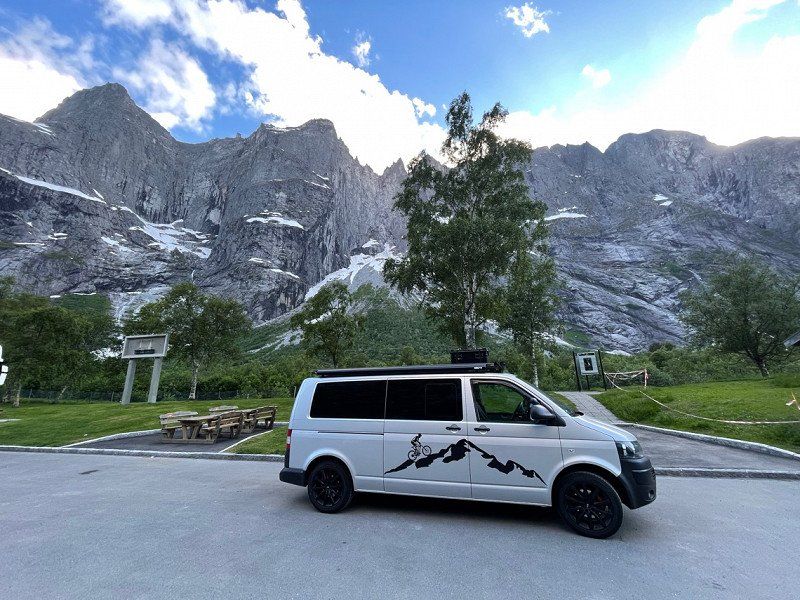
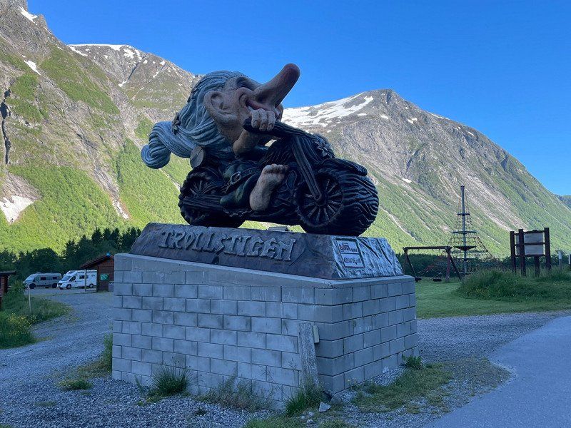
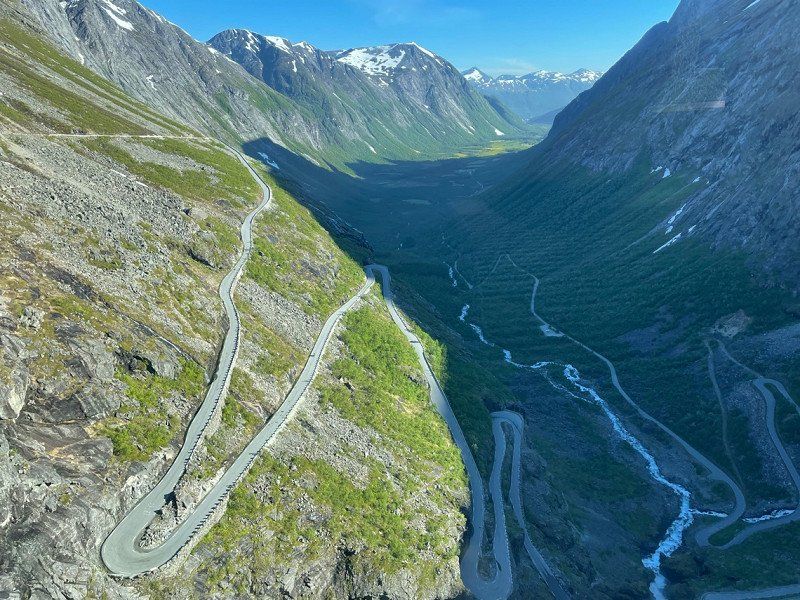
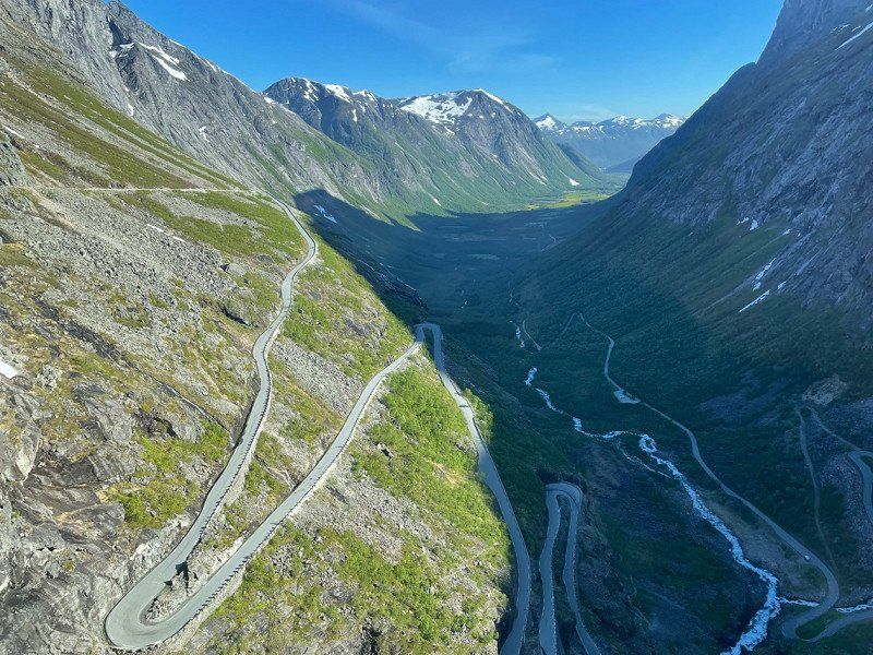
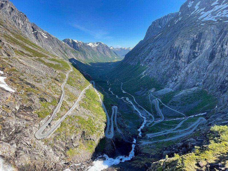
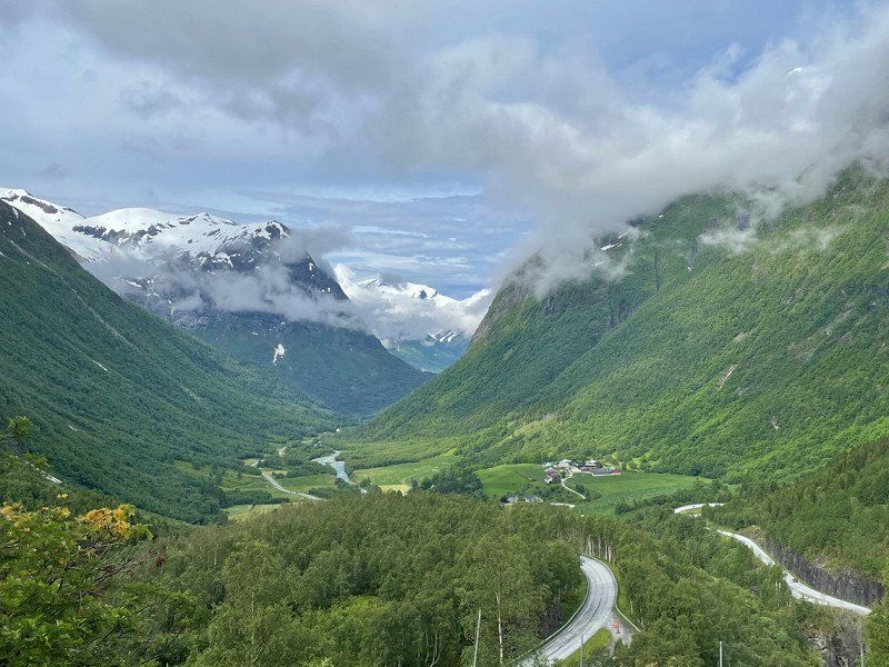
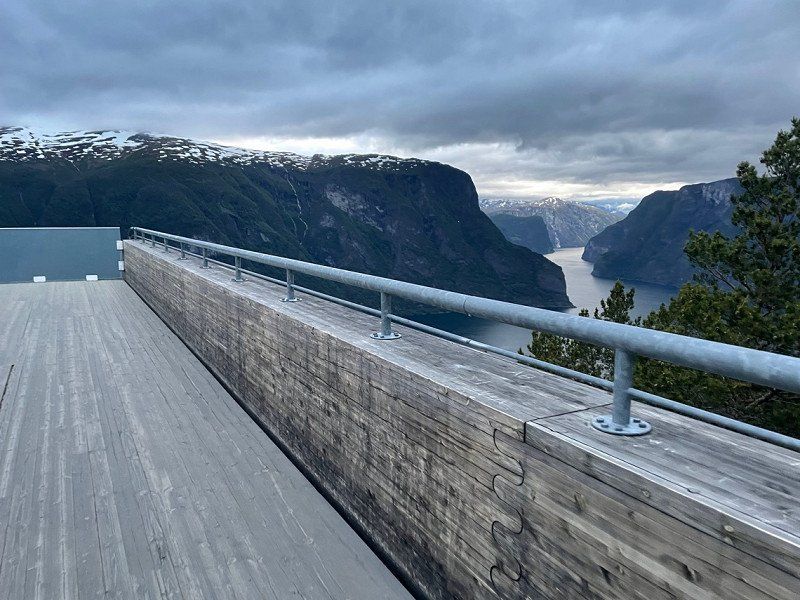
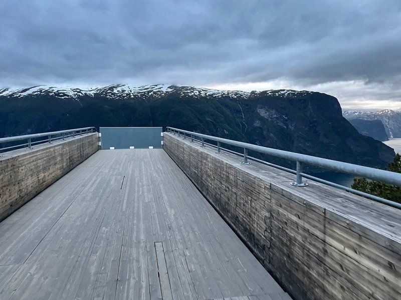
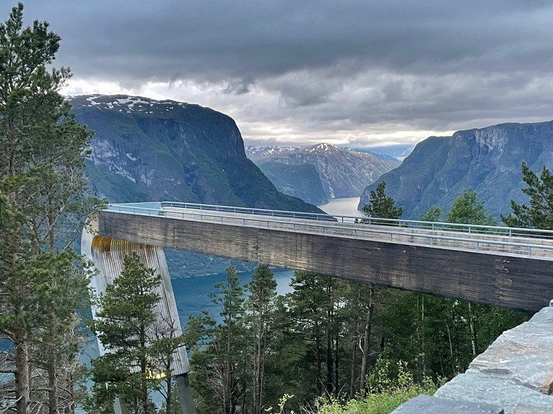
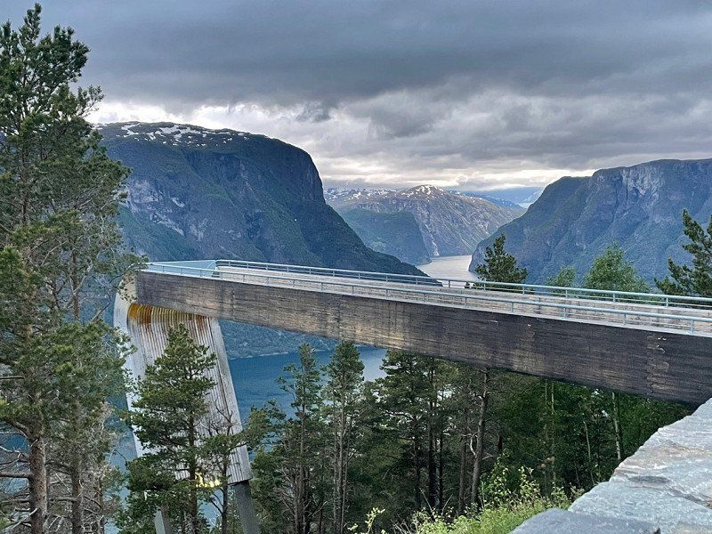
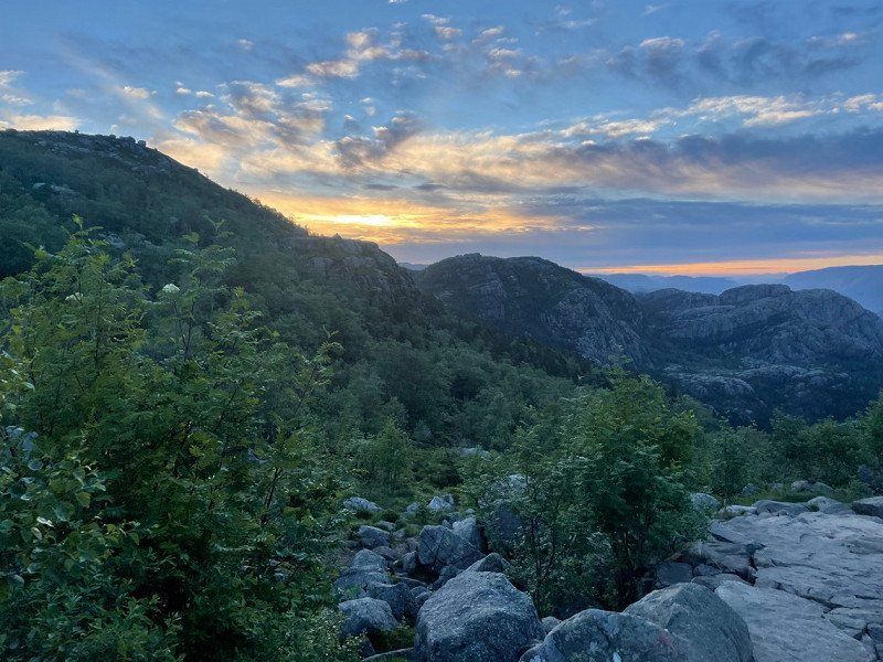
Trollstigen, Åndalsnes, Norwegen
After the beautiful adventure in the national park, we drove to a campsite on Tollstigen and spent the night there.
After that, of course, another little hike.
As of 04.07.2022.
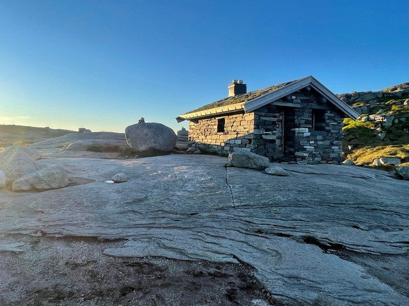
This campsite was the most beautiful in all of Norway.
Trollstigen, 6300 Åndalsnes, Norwegen
62° 27' 17.7" N 7° 39' 57.5" E
62.4549066 7.6659830
• Head southwest on Isterdalsvegen (63). Go for 35.1 km.
• Turn right onto 63. Go for 4.3 km.
• Continue on Lingestranda (650). Go for 38.7 km.
• Turn right onto Giskemovegen (522). Go for 1.0 km.
• Continue on 522. Go for 43 m.
• Continue on Giskemovegen (522). Go for 142 m.
• Continue on Valgermo (522). Go for 97 m.
• Continue on Giskemovegen (522). Go for 176 m.
• Turn right onto Ålesundsvegen (E39/E136). Go for 21.4 km.
• Pass 2 roundabouts and continue on E39. Go for 2.9 km.
• Take the 1st exit from roundabout onto Furnesvegen (E39) toward Molde. Go for 2.5 km.
• Take the Vestnes-Molde Ferry. Stay on for 11.3 km.
• Head toward Fannestrandvegen on E39. Go for 786 m.
• Take the 1st exit from roundabout onto Fannefjordsvegen (E39) toward Trondheim/Kristiansund. Go for 3.2 km.
• Take the 2nd exit from roundabout onto Fannefjordsvegen (E39) toward Trondheim/Kristiansund/Eide. Go for 942 m.
• Take the 3rd exit from roundabout onto Årødalsvegen toward Eide/Einesvågen. Go for 2.0 km.
• Continue on 64. Go for 7.3 km.
• Pass 2 roundabouts and continue on Fræneidet (64). Go for 31.5 km.
• Turn right onto 64. Go for 2.5 km.
• Arrive at Atlanterhavsvegen (64).
☍
166,1 km
(3 hrs. 7 min.)
Day
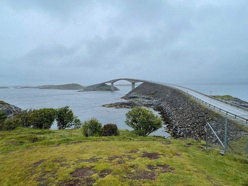
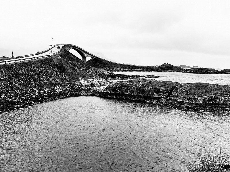
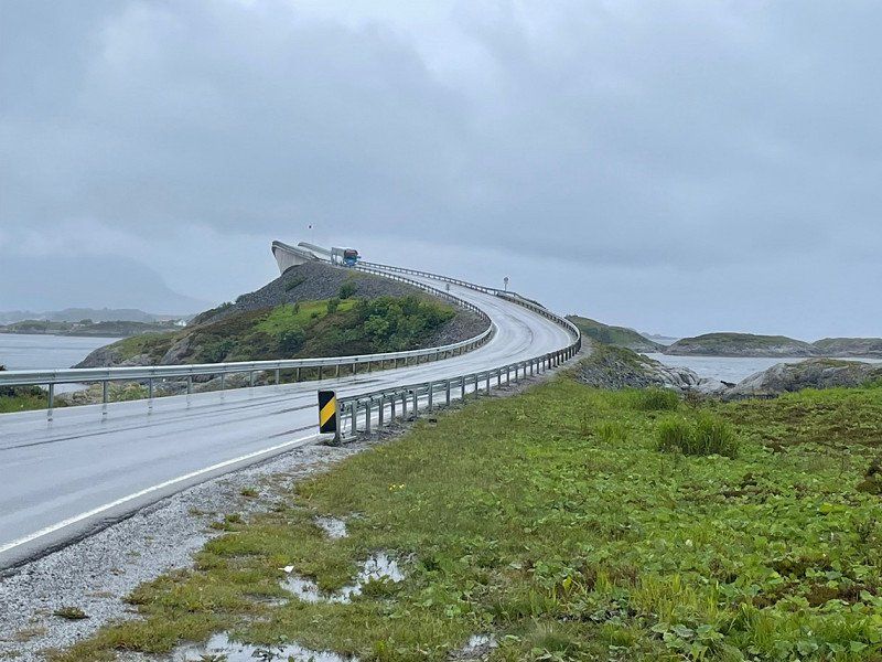
Atlanterhavsveien, Vevang, Norwegen
Unfortunately, after Trollstigen it was a rainy day so we decided to drive to the Atlantic Bridge because we didn't know where to go with us🤭
Atlanterhavsveien, 6494 Vevang, Norwegen
63° 0' 42.8" N 7° 19' 16.5" E
63.0118985 7.3212509
• Head southwest on Atlanterhavsvegen (64). Go for 2.5 km.
• Turn left onto Vevangvegen (64). Go for 29.2 km.
• Pass 2 roundabouts and continue on Malmefjordvegen (64). Go for 9.6 km.
• Continue on Årødalsvegen. Go for 1.9 km.
• Take the 1st exit from roundabout onto Fannefjordsvegen (E39). Go for 893 m.
• Take the 1st exit from roundabout onto Fannefjordsvegen (E39) toward Ålesund/Molde. Go for 3.2 km.
• Take the 3rd exit from roundabout onto Fannestrandvegen (E39). Go for 492 m.
• Turn left onto E39. Go for 347 m.
• Take the Molde-Vestnes Ferry. Stay on for 11.3 km.
• Head south on Furnesvegen (E39). Go for 2.5 km.
• Take the 2nd exit from roundabout onto Stokkelandsvegen (E39) toward Ålesund. Go for 1.2 km.
• Pass 2 roundabouts and continue on Brastadstranda (E39). Go for 23.2 km.
• Turn left onto Giskemovegen (522). Go for 176 m.
• Continue on Valgermo (522). Go for 97 m.
• Continue on Giskemovegen (522). Go for 142 m.
• Continue on 522. Go for 43 m.
• Continue on Giskemovegen (522). Go for 1.0 km.
• Turn left onto Storfjordvegen (650). Go for 38.7 km.
• Turn right onto 63. Go for 156 m.
• Take the Linge-Eidsdal Ferry. Stay on for 2.6 km.
• Head toward Ytterdalsgata on 63. Go for 11.8 km.
• Turn right onto Indreeidstunnelen (63). Go for 5.2 km.
• Turn right onto Ørnevegen (63) toward Geiranger. Go for 7.7 km.
• Arrive at Ørnevegen (63).
☍
154,1 km
(3 hrs. 27 min.)
Day
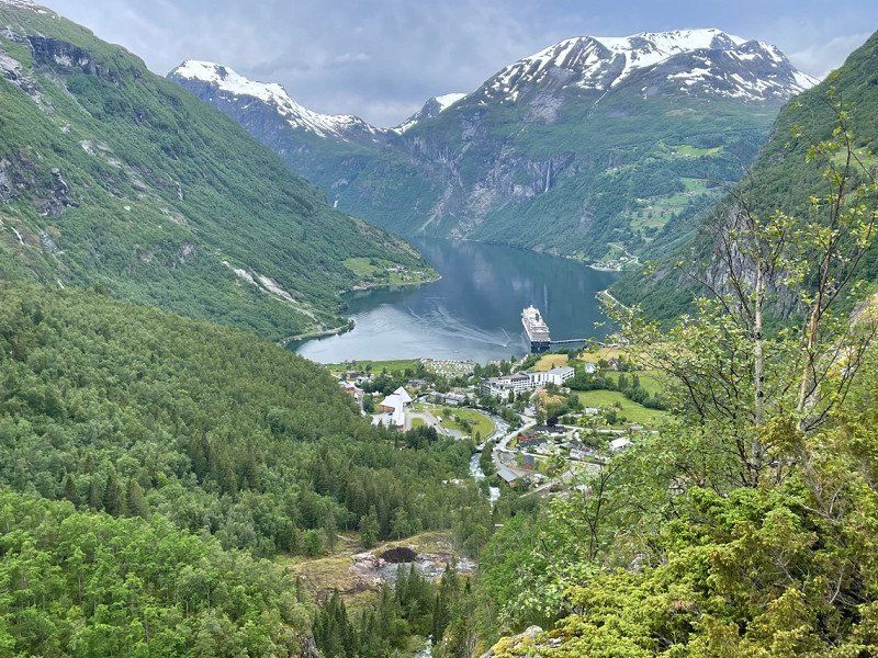
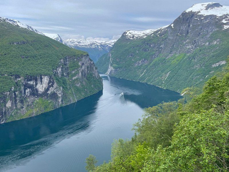
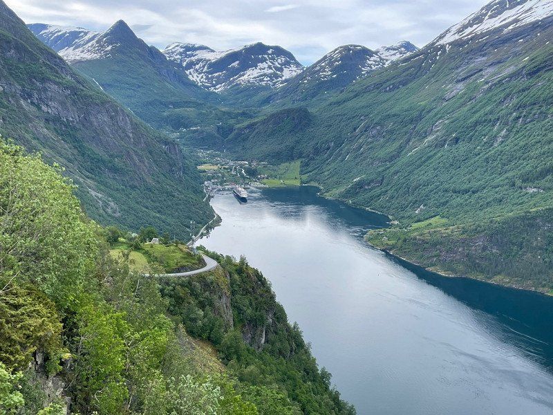
Geiranger Fjord, Geiranger, Norwegen
After the Atlantic Bridge we drove straight to Geiranger and slept there so that we could get to Geiranger early the next morning because it was teeming with tourists there🙈
Geirangerfjord, Stranda, Norwegen
62° 6' 13.4" N 7° 11' 45.6" E
62.1037109 7.1959928
• Head southeast on Ørnevegen (63). Go for 307 m.
• Turn right onto 63. Go for 119 m.
• Take the Geiranger-Hellesylt Ferry. Stay on for 20.1 km.
• Head toward Hellesyltvegen on 60. Go for 578 m.
• Turn right onto Hellesyltvegen (60). Go for 878 m.
• Turn left onto Langedalsvegen (60). Go for 25.0 km.
• Turn left onto E39 toward Bergen/Stryn/60. Go for 8.3 km.
• Turn left onto Nordfjordvegen (15) toward Stryn. Go for 15.8 km.
• Take the 2nd exit from roundabout onto Tonningsgata (15) toward Otta. Go for 20.8 km.
• Arrive at Strynevegen (15). Your destination is on the left.
☍
91,9 km
(2 hrs. 2 min.)
Day
Oppstryn, Norwegen
Since Oppstyn was on the way, we stopped here for a moment because I thought it was a very nice place to relax.
61° 54' 33.7" N 7° 3' 22.1" E
61.9093641 7.0561354
• Head northwest on Strynevegen (15). Go for 20.8 km.
• Take the 2nd exit from roundabout onto Visnesvegen (60) toward E39/Førde/Byrkjelo/Måløy. Go for 10.5 km.
• Turn right. Go for 19 m.
• Turn left. Go for 60 m.
• Arrive at your destination.
☍
31,3 km
( 27 min.)
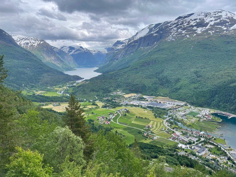
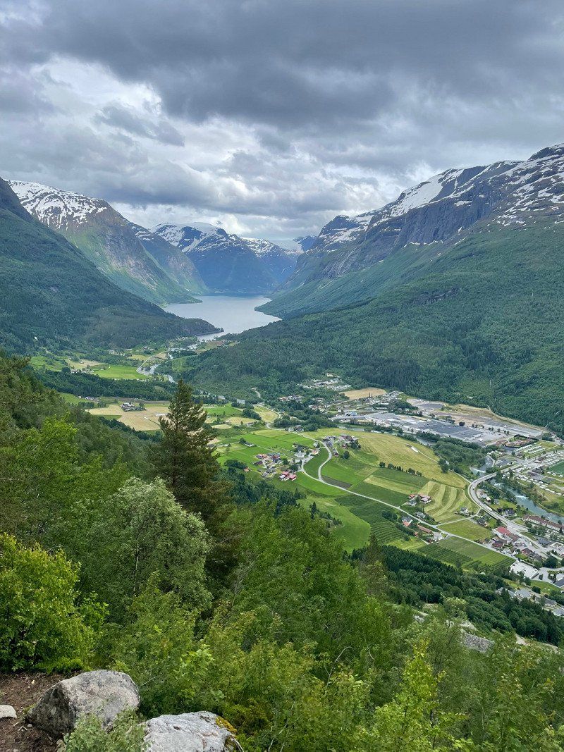
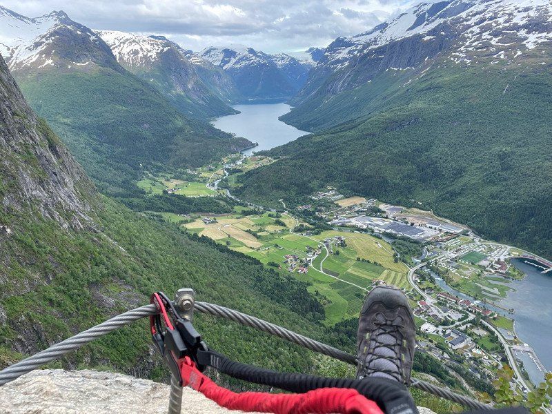
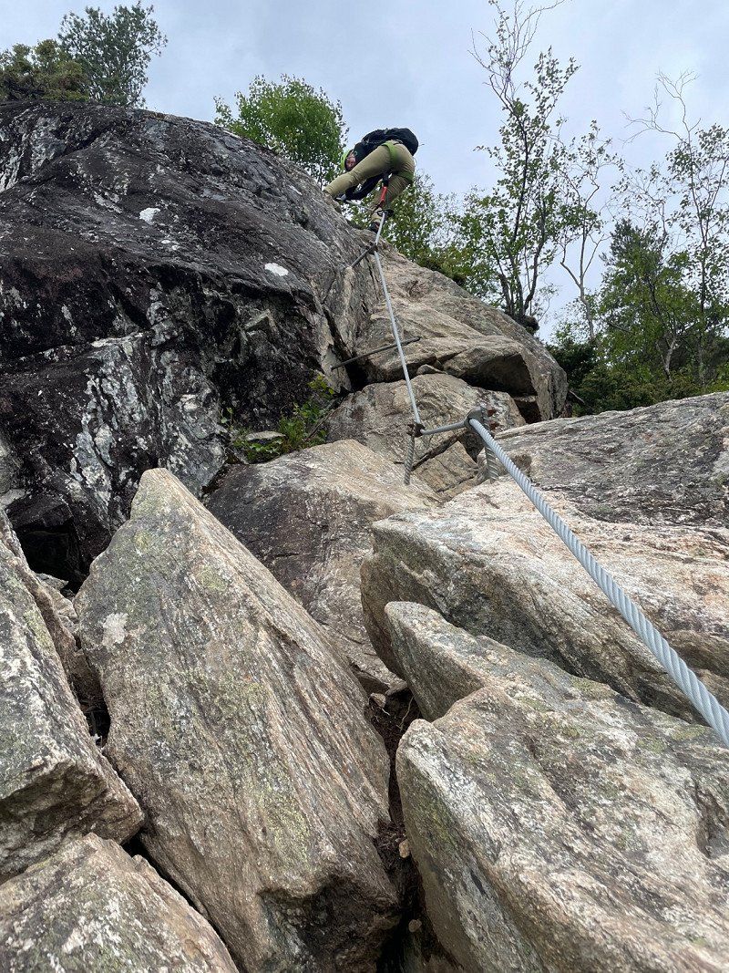
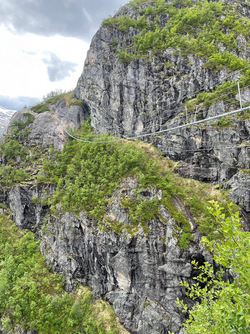
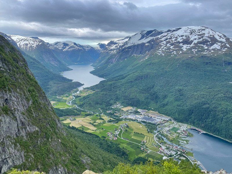
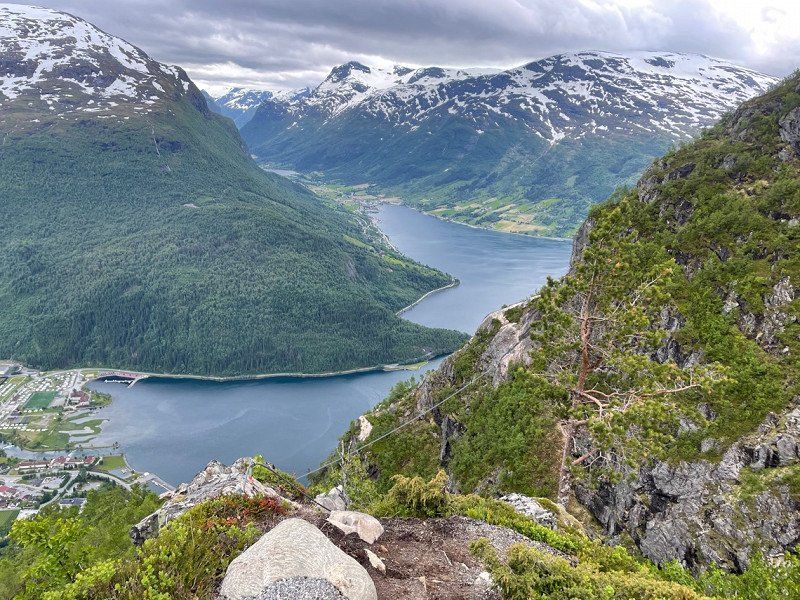
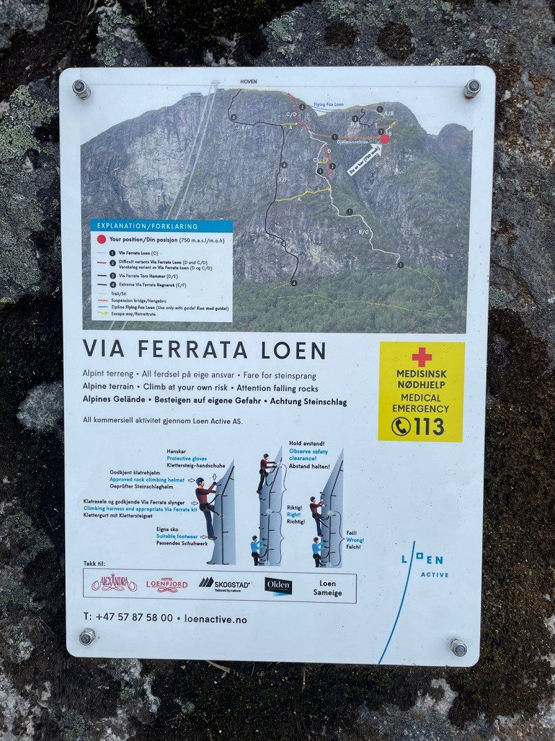
Loen, Norwegen
Loen was by far the best via ferrata we have been on so far.
But once at the top and rested, it quickly gets cold. So we went down with the ski lift.
However, it cost €82 for 2 people, which I thought was very expensive.
61° 52' 15.8" N 6° 50' 52.9" E
61.8710579 6.8480176
• Head west. Go for 60 m.
• Turn right toward Fjordvegen/60. Go for 19 m.
• Turn right onto Fjordvegen (60). Go for 46.9 km.
• Turn left onto Breimsvegen (E39). Go for 19.7 km.
• Arrive at Jølstravegen (E39). Your destination is on the left.
☍
66,7 km
(1 hrs. 1 min.)
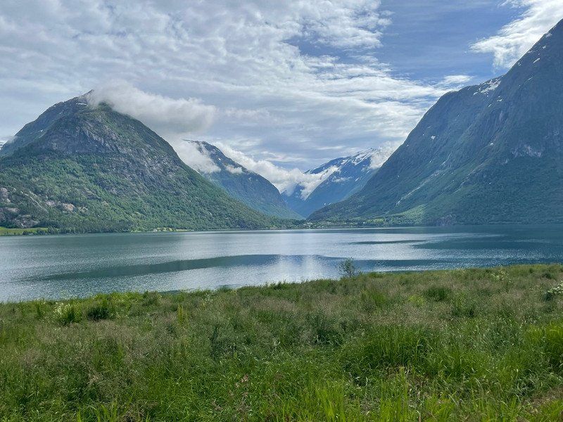
Skei, Norwegen
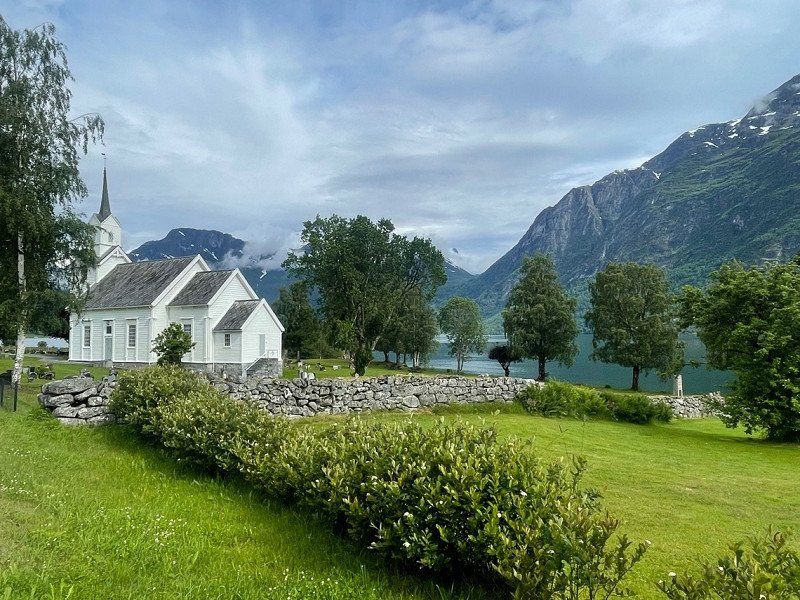
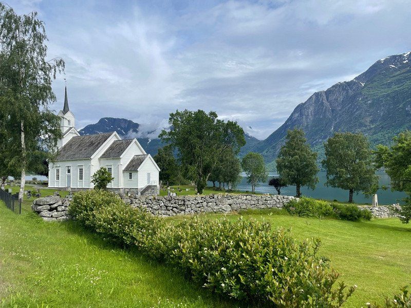
After Loen, the path led us through Skei to this small town with a beautiful little church. I'm not a church fan, but I had to photograph them.
61° 34' 22.2" N 6° 28' 51.2" E
61.5728366 6.4808958
• Head southwest on Jølstravegen (E39). Go for 164 m.
• Take the 2nd exit from roundabout onto 5 toward Sogndal/Fjærland. Go for 61.1 km.
• Take the 3rd exit from roundabout onto Gravensteinsgata (5) toward E16/Lærdal/55/Lom. Go for 133 m.
• Pass 3 roundabouts and continue on 5. Go for 17.8 km.
• Turn left onto 5. Go for 60 m.
• Take the Mannheller-Fodnes Ferry. Stay on for 3.1 km.
• Head east on 5. Go for 8.8 km.
• Take the 2nd exit from roundabout onto Fodnesvegen (5) toward E16. Go for 227 m.
• Take the 2nd exit from roundabout onto 5 toward E16/Oslo/Bergen/Aurland. Go for 6.8 km.
• Take the 1st exit from roundabout onto E16 toward Bergen/Aurland. Go for 25.1 km.
• Take the 1st exit from roundabout toward Sentrum. Go for 43 m.
• Continue on Skulevegen (5627). Go for 1.5 km.
• Turn right onto Øvregata. Go for 162 m.
• Continue on Bjørgavegen (5627). Go for 1.7 km.
• Continue on Kvam (5627). Go for 96 m.
• Continue on Bjørgavegen (5627). Go for 6.2 km.
• Arrive at Bjørgavegen (5627). Your destination is on the right.
☍
132,9 km
(2 hrs. 33 min.)
Stegastein, Bjørgavegen, Aurland, Norwegen
The Stegastein is nothing special, but if it is almost on the way you should take a look at it.
Bjørgavegen 83, 5745 Aurland, Norwegen
60° 54' 31.8" N 7° 12' 43.8" E
60.9088253 7.2121707
• Head north on Bjørgavegen (5627). Go for 6.2 km.
• Continue on Kvam (5627). Go for 96 m.
• Continue on Bjørgavegen (5627). Go for 1.7 km.
• Continue on Øvregata. Go for 162 m.
• Turn left onto Skulevegen (5627). Go for 1.5 km.
• Take the 1st exit from roundabout onto E16 toward Bergen/Voss. Go for 53.3 km.
• Pass 5 roundabouts and continue on Strandavegen (E16). Go for 19.5 km.
• Continue on 13. Go for 874 m.
• Turn left onto Hardangervegen (13). Go for 30.2 km.
• Take the 1st exit from roundabout onto Vallaviktunnelen (13). Go for 3.3 km.
• Take the 1st exit from Butunnelen roundabout onto Eidfjordvegen (7). Go for 32.3 km.
• Turn left. Go for 23 m.
• Turn right. Go for 99 m.
• Turn left. Go for 209 m.
• Arrive at your destination on the left.
☍
149,4 km
(2 hrs. 25 min.)
Day
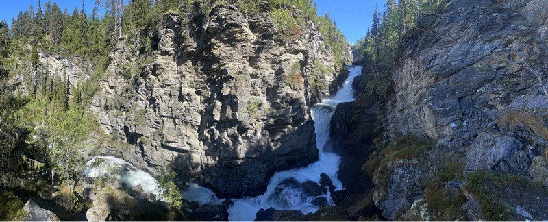
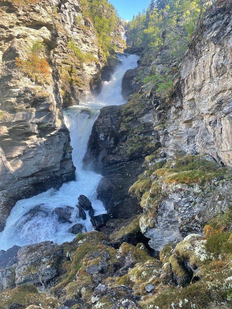
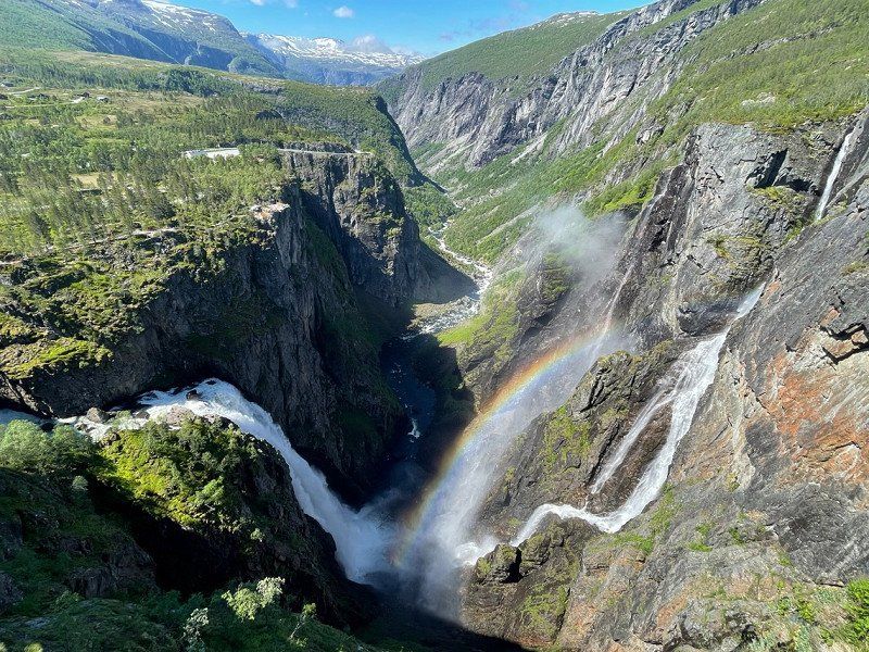
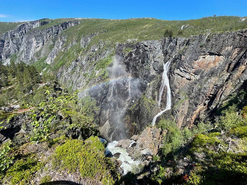
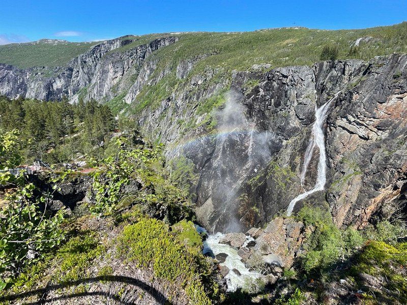
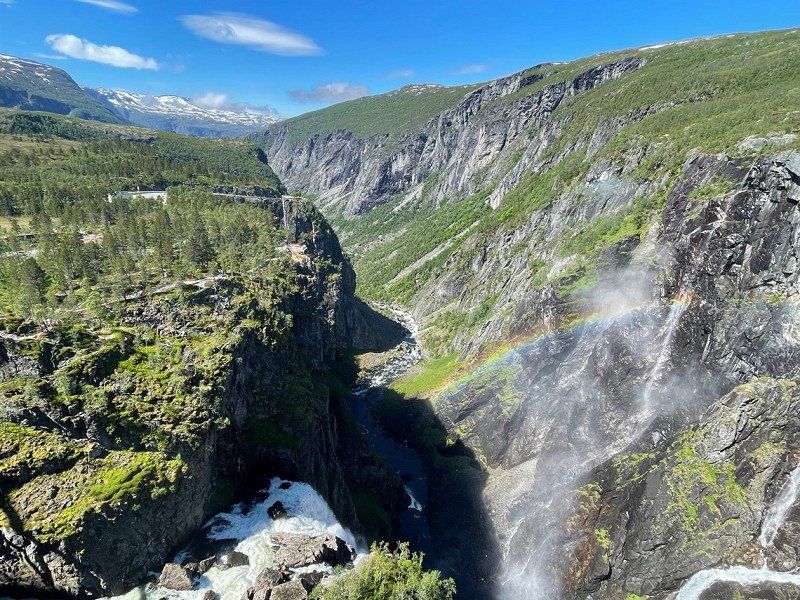
Vøringfossen, Eidfjord, Norwegen
The Vøringsfossen blew my mind😍
It's amazing how different nature is in Norway.
Eidfjord, Norwegen
60° 25' 35.7" N 7° 15' 5.3" E
60.4265721 7.2514658
• Head west. Go for 209 m.
• Turn right. Go for 99 m.
• Turn left toward Hardangervidda/7. Go for 23 m.
• Turn right onto Hardangervidda (7). Go for 32.3 km.
• Take the 1st exit from Butunnelen roundabout onto Butunnelen (13). Go for 48.7 km.
• Turn left onto Skjeggedalsvegen. Go for 690 m.
• Turn slightly right onto Skjeggedalsvegen. Go for 696 m.
• Turn slightly left onto Skjeggedalsvegen. Go for 4.7 km.
• Continue on Skjeggedal. Go for 5.2 km.
• Arrive at your destination.
☍
92,5 km
(1 hrs. 50 min.)
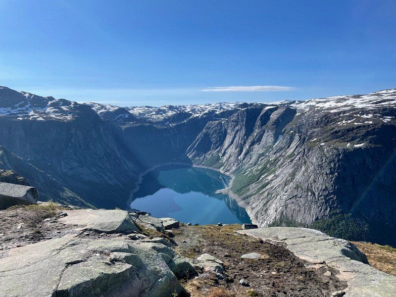
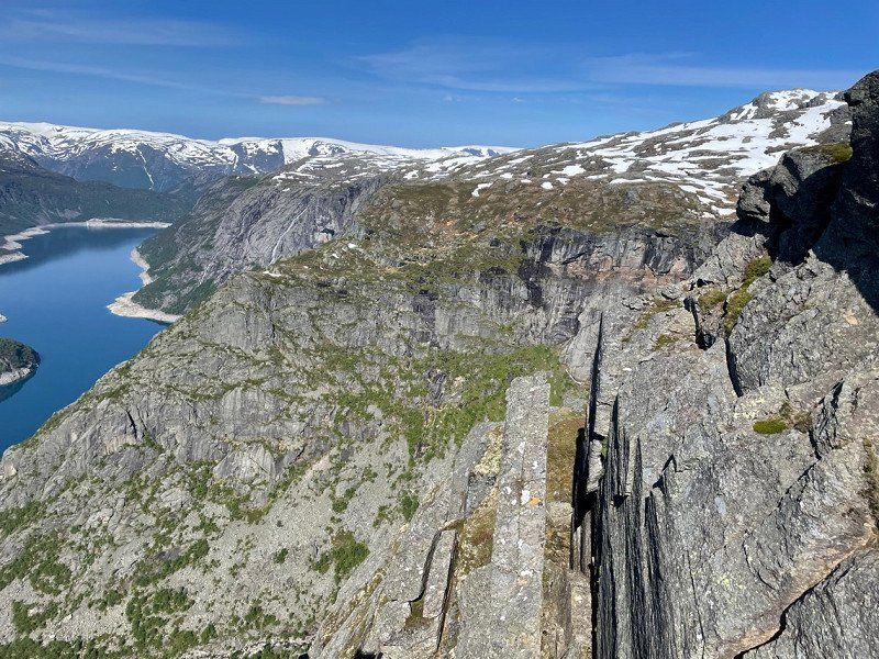
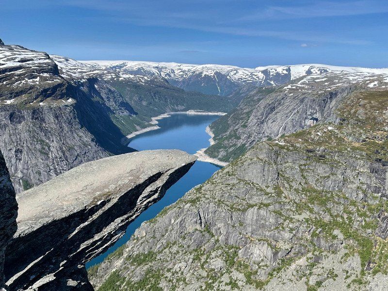
Trolltunga, Røldal, Norwegen
Trolltunga, who doesn't know the well-known bad tongue. You just have to stand on it.
However, the trek to get there was not easy.
There are only two parking spaces and the upper one can only be passed by car.
So we had to park in the lower parking lot for 250 NOK. Pretty expensive. A shuttle runs to the second parking lot, but it also costs 200Nok. We allowed ourselves that but from parking lot 2 to the 3rd parking lot again 200Nok was too much for us so we preferred to walk the 4km extremely steep road. It was a total of 28 km, which was very exhausting even though we are both very fit.
Trolltunga, Ullensvang, Norwegen
60° 7' 27" N 6° 44' 24" E
60.1241670 6.7400000
• Head southwest. Go for 3.5 km.
• Continue on Skjeggedal. Go for 6.1 km.
• Turn slightly right onto Skjeggedalsvegen. Go for 674 m.
• Turn slightly right onto Skjeggedalsvegen. Go for 1.0 km.
• Turn left onto Stanavegen (13). Go for 5.8 km.
• Turn right onto Eitrheimsvegen. Go for 185 m.
• Turn right onto Eitrheimsvegen. Go for 216 m.
• Take the 1st exit from roundabout onto Eitrheimsvegen (49). Go for 2.7 km.
• Take the 2nd exit from roundabout onto 49. Go for 12.5 km.
• Turn right onto 49. Go for 62 m.
• Continue on Austrepollen (49). Go for 146 m.
• Continue on 49. Go for 292 m.
• Continue on Kamrygg (49). Go for 110 m.
• Continue on 49. Go for 4.8 km.
• Continue on Nordrepollen (49). Go for 122 m.
• Continue on 49. Go for 474 m.
• Continue on Jondalstunnelen (49). Go for 10.1 km.
• Continue on 49. Go for 584 m.
• Continue on Torsnestunnelen (49). Go for 605 m.
• Continue on 49. Go for 386 m.
• Take the 1st exit from roundabout onto Belsnesvegen (49). Go for 5.4 km.
• Continue on Jonavegen (550). Go for 25 m.
• Arrive at Jonavegen (550). Your destination is on the right.
☍
55,8 km
(1 hrs. 9 min.)
Jondal, Norwegen
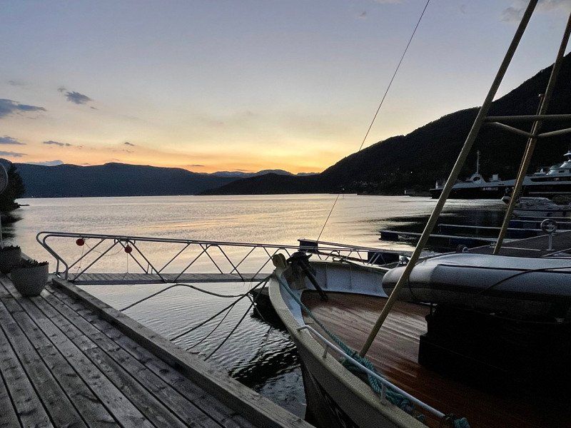
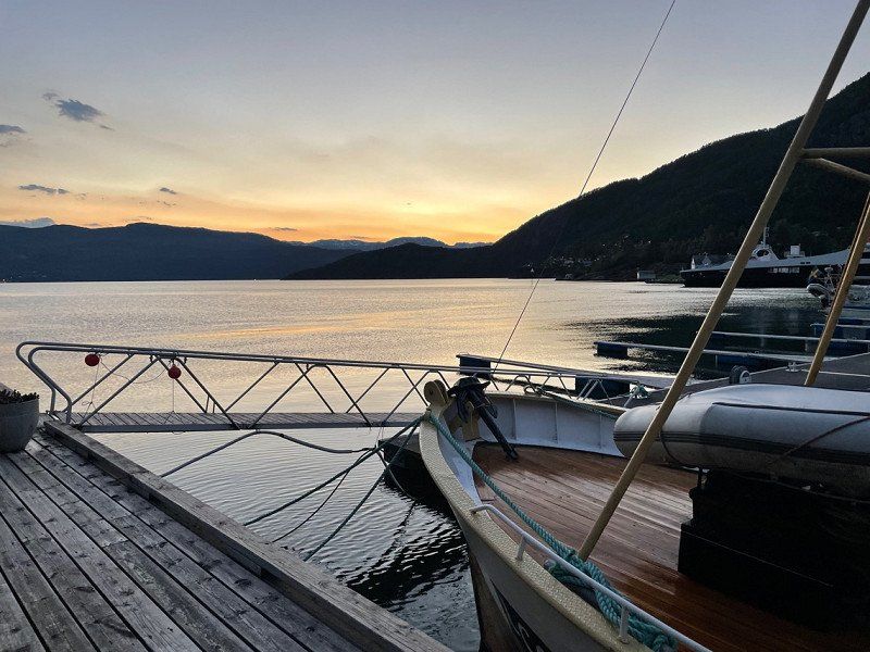
After Trolltunga we drove towards Bergen and stopped at a campsite at a port. We saw a beautiful sunset there 😍
60° 16' 33.6" N 6° 15' 9" E
60.2760065 6.2525002
• Head toward Belsnesvegen on Jonavegen (550). Go for 25 m.
• Turn right onto 49. Go for 98 m.
• Take the Jondal-Trøvikbygd Ferry. Stay on for 5.2 km.
• Head toward Skutevik on Tørvikbygdvegen (49). Go for 191 m.
• Turn right onto Tørvikbygdvegen (49). Go for 12.7 km.
• Turn left onto Steinsdalsvegen (49). Go for 69 m.
• Take the 1st exit from roundabout onto Steinsdalsvegen (49). Go for 7.2 km.
• Continue on 7. Go for 25 m.
• Continue on 49. Go for 20.6 km.
• Take the 1st exit from roundabout onto Samnangervegen (49) toward Bergen/E16. Go for 14.3 km.
• Take the 3rd exit from roundabout onto Hardangervegen (E16). Go for 9.7 km.
• Take the 1st exit from roundabout onto Arnavegen (E16) toward Bergen Nord/E39. Go for 581 m.
• Take the 2nd exit from roundabout onto Arnavegen (E16) toward E39/Bergen/Åsane. Go for 9.9 km.
• Take the 3rd exit from roundabout onto E16/E39 (Åsaneveien) toward Bergen. Go for 12.9 km.
• Keep left toward Sentrum. Go for 128 m.
• Take left ramp onto Fjøsangerveien toward Sentrum. Go for 821 m.
• Turn left onto Fjøsangerveien toward E39/E16/Åsane/E39N/Sentrum. Go for 27 m.
• Continue on Strømgaten. Go for 79 m.
• Turn right onto Lars Hilles gate. Go for 339 m.
• Continue on Foreningsgaten. Go for 73 m.
• Continue on Vaskerelven (5334). Go for 123 m.
• Turn right onto Vaskerelvsmauet. Go for 24 m.
• Arrive at Vaskerelvsmauet. Your destination is on the right.
☍
95,0 km
(2 hrs. 5 min.)
Day
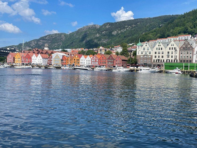
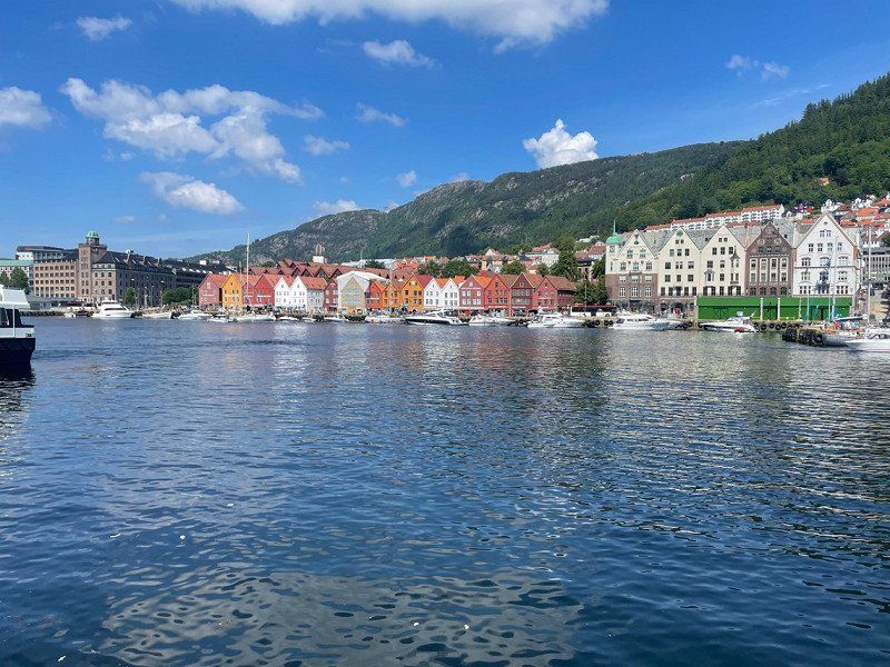
Bergen, Norwegen
We thought Bergen is a must-see and made a detour to Bergen.
Honestly?
Cities are just not for us🙈
60° 23' 28.5" N 5° 19' 19.4" E
60.3912628 5.3220544
• Head toward Torgallmenningen on Vaskerelvsmauet. Go for 72 m.
• Continue on Øvre Ole Bulls plass. Go for 19 m.
• Turn left onto Øvre Ole Bulls plass. Go for 86 m.
• Turn left onto Øvre Ole Bulls plass. Go for 20 m.
• Continue on Engen. Go for 69 m.
• Turn right onto Engen (5334). Go for 133 m.
• Turn left onto Teatergaten (5347). Go for 85 m.
• Turn right onto Komediebakken (5347). Go for 144 m.
• Turn left onto Nøstegaten (555). Go for 599 m.
• Keep right onto O. J. Brochs gate (5352) toward E16/E39/Møhlenpris/Terminal Dokken. Go for 169 m.
• Take the 2nd exit from roundabout onto Nygårdstunnelen (5347) toward E16/E39. Go for 1.1 km.
• Take ramp onto Fjøsangerveien (E39) toward Stavanger. Go for 3.2 km.
• Pass 2 roundabouts and continue on E39 (Halhjemsvegen). Go for 26.5 km.
• Keep right onto Halhjemsvegen (E39) toward Stavanger. Go for 271 m.
• Turn slightly right onto 549. Go for 97 m.
• Take the Halhjem-Våge Ferry. Stay on for 12.4 km.
• Head southwest on Hegglandsvegen (549). Go for 406 m.
• Take the 1st exit from roundabout onto Hollekjevegen (549). Go for 326 m.
• Turn right onto Landavegen toward Lande. Go for 215 m.
• Turn left onto Landavegen. Go for 126 m.
• Arrive at Landavegen. Your destination is on the right.
☍
45,9 km
(1 hrs. 22 min.)
Tysnes, Norwegen
60° 2' 29.8" N 5° 31' 9.9" E
60.0416100 5.5194210
• Head west on Landavegen. Go for 126 m.
• Turn right onto Landavegen. Go for 215 m.
• Turn right onto Hollekjevegen (549). Go for 10.5 km.
• Arrive at Flatråkervegen (549).
☍
10,8 km
( 12 min.)
Nordbustaddalen 581, Flatråker, Norwegen
5687 Flatråker, Norwegen
59° 57' 26.2" N 5° 30' 53.7" E
59.9572755 5.5149078
• Head south on Flatråkervegen (549). Go for 9.8 km.
• Turn right onto Hodnanesvegen (549). Go for 638 m.
• Take the Hodnanes-Jektevik Ferry. Stay on for 2.3 km.
• Head southwest on 549. Go for 38 m.
• Turn right onto 549. Go for 125 m.
• Turn left onto E39. Go for 13.3 km.
• Keep right toward E39. Go for 306 m.
• Continue on E39. Go for 45.2 km.
• Take ramp onto Grindafjordvegen (E39/E134) toward Stavanger/Haugesund. Go for 4.7 km.
• Take the 3rd exit from roundabout onto Skjoldastraumsvegen (515) toward Nedstrand/Skjoldastraumen. Go for 33.5 km.
• Take the 1st exit from roundabout. Go for 25 m.
• Continue on Hinderåvåg (4788). Go for 123 m.
• Turn slightly right onto Hinderåvåg. Go for 99 m.
• Turn right onto Hinderåvåg. Go for 83 m.
• Turn slightly right onto Hinderåvåg. Go for 48 m.
• Arrive at Hinderåvåg. Your destination is on the right.
☍
110,4 km
(2 hrs. 6 min.)
Day
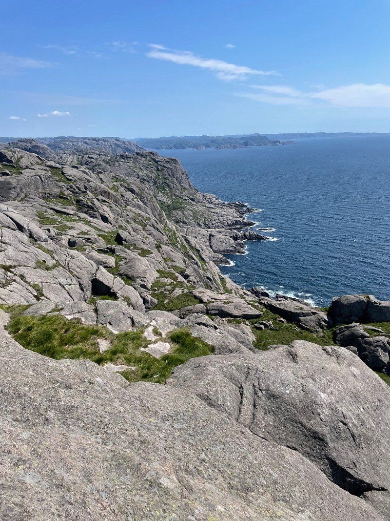
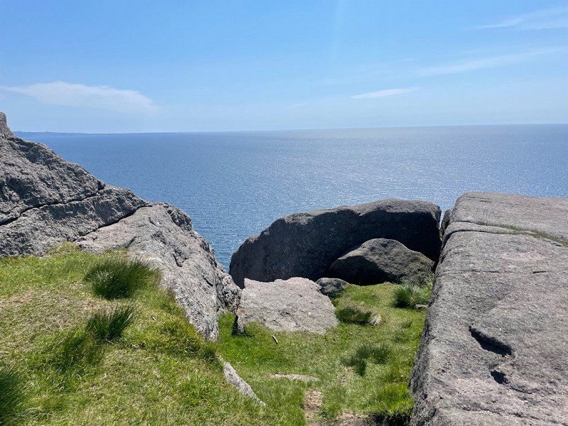
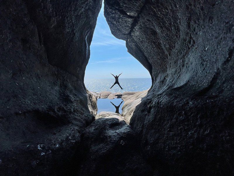
Hindaråvåg, Norwegen
After Bergen and two short stops we went to "Klein Trolltunga" for hiking.
Super nice hike, perfect view and the best weather.
59° 20' 54.3" N 5° 47' 51.5" E
59.3484205 5.7976377
• Head south on Hinderåvåg. Go for 131 m.
• Turn left onto Hinderåvåg. Go for 99 m.
• Turn slightly left onto Hinderåvåg (4788). Go for 145 m.
• Take the 1st exit from roundabout onto Nedstrandsvegen (515). Go for 3.5 km.
• Turn right onto Stranda (515). Go for 43 m.
• Take the Nedstrand-Nesheim Ferry. Stay on for 10.2 km.
• Take the Nesheim-Nord-Hidle Ferry. Stay on for 2.3 km.
• Take the Nord-Hilde-Helgøy Ferry. Stay on for 2.4 km.
• Take the Helgøy-Eidsund Ferry. Stay on for 5.3 km.
• Take the Eidsund-Halsnøy Ferry. Stay on for 3.6 km.
• Take the Halsnøy-Judaberg Ferry. Stay on for 5.2 km.
• Head southwest on 519. Go for 28 m.
• Turn right onto 519. Go for 100 m.
• Turn right onto 519. Go for 81 m.
• Turn left onto 519. Go for 2.2 km.
• Pass 2 roundabouts and continue on Hanasandveien (519). Go for 14.4 km.
• Turn left onto E39. Go for 17.0 km.
• Pass 2 roundabouts and continue on Ytre Ringvei Vest (E39). Go for 5.6 km.
• Take the exit. Go for 700 m.
• Take the 1st exit from roundabout onto Motorveien. Go for 253 m.
• Take the 2nd exit from roundabout onto Hundvågtunnelen (13). Go for 6.3 km.
• Take the 1st exit from roundabout onto Ryfylketunnelen (13). Go for 14.9 km.
• Take the 1st exit from roundabout onto Ryfylkevegen (13). Go for 115 m.
• Pass 3 roundabouts and continue on Ryfylkevegen (523). Go for 10.9 km.
• Turn left onto Preikestolvegen (4642). Go for 5.1 km.
• Turn slightly left onto Preikestolvegen (4642). Go for 23 m.
• Arrive at Preikestolvegen (4642). Your destination is on the left.
☍
110,7 km
(2 hrs. 30 min.)
Day
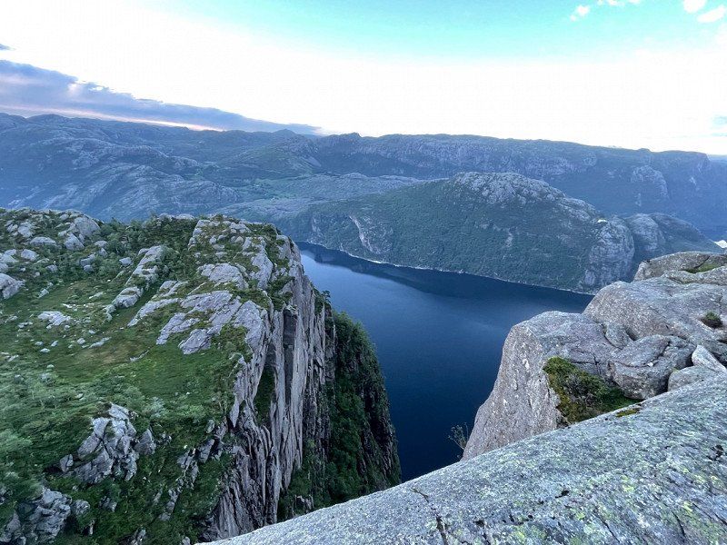
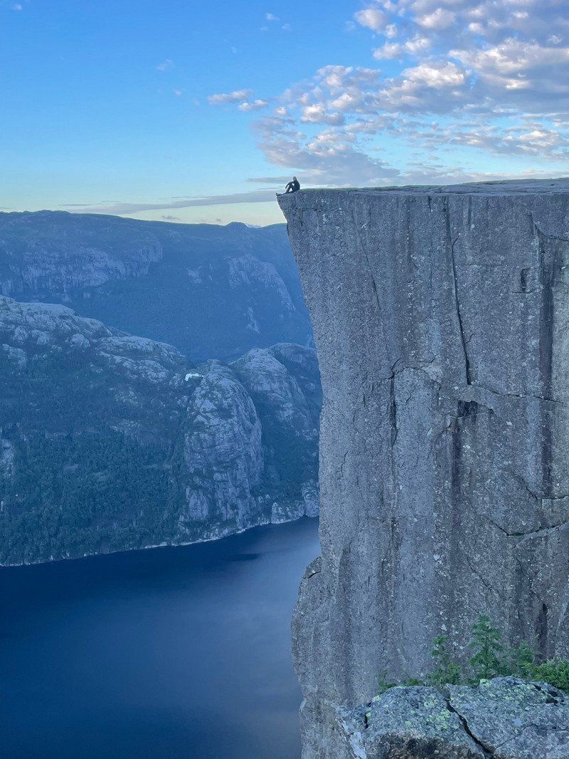
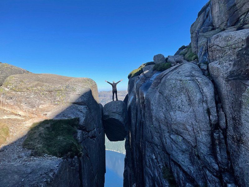
Preikestolen fjellstue, Preikestolvegen, Jørpeland, Norwegen
Of course, like most of us, we walked to the Preikestolen and started walking at 4 in the morning. When we walked there, some came towards us, just amazing how popular this rock is and what a beautiful picture people make.
Preikestolvegen 521, 4105 Jørpeland, Norwegen
58° 59' 28.6" N 6° 8' 18.7" E
58.9912816 6.1385197
• Head north on Preikestolvegen (4642). Go for 5.1 km.
• Turn left onto Ryfylkevegen (523). Go for 10.9 km.
• Take the 2nd exit from roundabout onto Ryfylkevegen (523). Go for 451 m.
• Keep right onto Ryfylkevegen (523) toward Sandnes/Lauvvik. Go for 562 m.
• Take the Ryfylkevegen Ferry. Stay on for 2.0 km.
• Head west on Lauvvikveien (508). Go for 5.9 km.
• Turn left onto Søredalen (508). Go for 3.6 km.
• Turn left onto Seldalveien (508). Go for 3.7 km.
• Turn left onto Oltedalsveien (45). Go for 58.2 km.
• Continue on Sirdalsveien (468). Go for 64 m.
• Take the 2nd exit from roundabout onto Sirdalsveien (975). Go for 1.6 km.
• Take the 1st exit from roundabout onto Sirdalsveien (975). Go for 13.2 km.
• Turn left onto 4224. Go for 59 m.
• Continue on Lyseveien (4224). Go for 3.1 km.
• Continue on 4224. Go for 11.5 km.
• Continue on Lysevegen (4224). Go for 9.8 km.
• Continue on 4224. Go for 183 m.
• Arrive at 4224.
☍
130,1 km
(2 hrs. 33 min.)
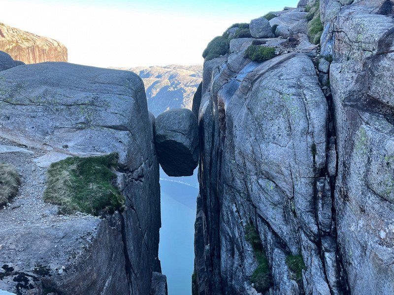
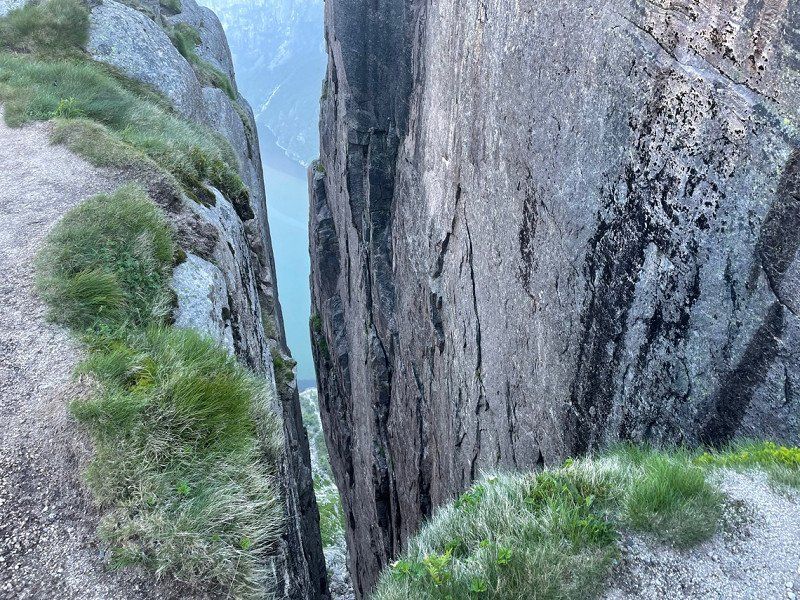
Kjerag, Lysebotn, Norwegen
After the Preikestolen we made our way to Kjeragbolten.
The hike was something different but not for the faint of heart.
Just as it is not for the faint-hearted to stand on a rock that is not quite 1 square meter at an altitude of 1080 meters. BUT what does it have to do 🤭
Kjerag, Sandnes, Norwegen
59° 2' 4.8" N 6° 34' 39.1" E
59.0346707 6.5775222
• Head toward Lysevegen on 4224. Go for 614 m.
• Turn right onto Lysevegen (4224). Go for 4.3 km.
• Continue on 4224. Go for 1.0 km.
• Continue on Lysevegen (4224). Go for 1.9 km.
• Take the Lysebotn-Flørli Ferry. Stay on for 13.6 km.
• Take the Flørli-Songesand Ferry. Stay on for 6.6 km.
• Take the Songesand-Forsand Ferry. Stay on for 19.7 km.
• Take the Forsand-Lauvvik Ferry. Stay on for 2.2 km.
• Head west on Lauvvikveien (508). Go for 5.9 km.
• Turn left onto Søredalen (508). Go for 3.6 km.
• Turn left onto Seldalveien (508). Go for 3.7 km.
• Turn right onto Oltedalsveien (45). Go for 11.2 km.
• Turn left onto Europavegen (E39) toward Kristiansand/Flekkefjord. Go for 39.9 km.
• Turn right onto Eiaveien (4264) toward Eia. Go for 13.1 km.
• Continue on 4264. Go for 2.2 km.
• Turn right onto 501. Go for 10.2 km.
• Turn left onto Sokndalsveien (44). Go for 3.3 km.
• Take the 2nd exit from roundabout onto Åna-Sira veien (44). Go for 18.5 km.
• Arrive at Åna Siraveien (44). Your destination is on the right.
☍
161,8 km
(3 hrs. 32 min.)
Day
Åna-Sira, Norwegen
After the breathtaking experience with the Kjeragbolten, we continued towards Bruffjellhålene, where there is a small and beautiful hike.
But before that we sleep again at a beautiful parking lot near a dam.
58° 17' 37.2" N 6° 26' 33.4" E
58.2936568 6.4426201
• Head east on Åna Siraveien (44). Go for 19.2 km.
• Take the 2nd exit from roundabout onto E39 toward Kristiansand. Go for 36.9 km.
• Take the 1st exit from roundabout. Go for 887 m.
• Continue toward E39. Go for 36 m.
• Take the 3rd exit from roundabout onto E39. Go for 8.7 km.
• Pass 3 roundabouts and continue on Mandalsveien (E39). Go for 16.8 km.
• Turn left toward Sentrum Vest. Go for 44 m.
• Turn right onto Halseveien (474). Go for 395 m.
• Turn right onto Gustav Vigelands vei (477). Go for 649 m.
• Continue on Fridtjof Nansens vei (477). Go for 664 m.
• Turn right onto Bankeveien (3994). Go for 653 m.
• Turn left onto Risøbank. Go for 344 m.
• Turn left onto Risøbank. Go for 15 m.
• Turn slightly right. Go for 78 m.
• Arrive at your destination.
☍
85,3 km
(1 hrs. 17 min.)
Day
Kanelstranda, Mandal, Norwegen
Since we booked a ferry in Kristiansand again, we drove towards the harbor and stopped again at Kanelstrand in Mandal.
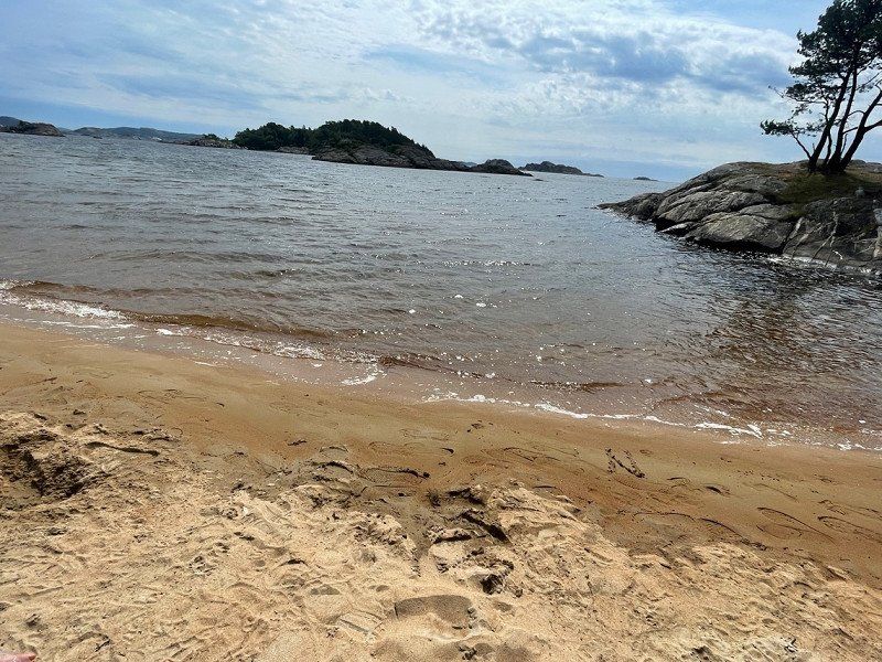
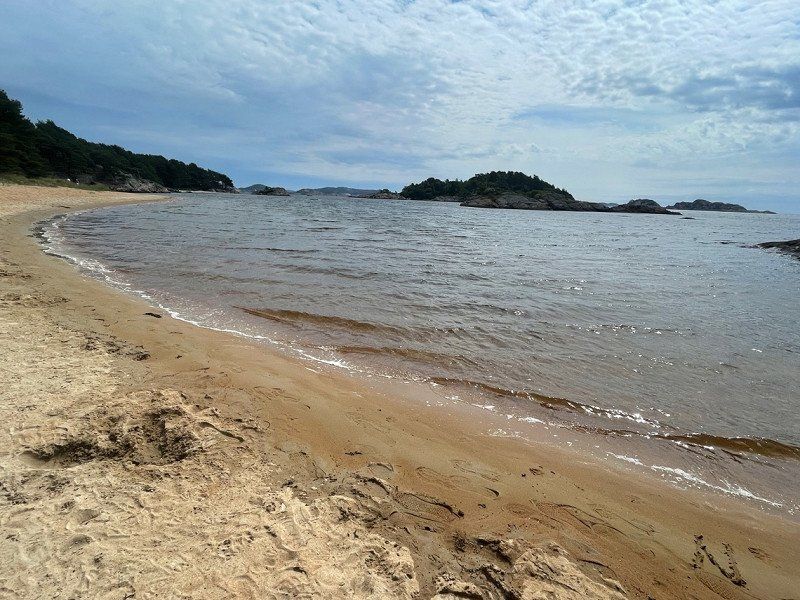
The sand looks like cinnamon and sugar 🤭 and the area here was also very idyllic.
58° 0' 53.4" N 7° 26' 14.1" E
58.0148437 7.4372559
• Head toward Risøbank. Go for 78 m.
• Turn slightly left onto Risøbank. Go for 15 m.
• Turn right onto Risøbank. Go for 344 m.
• Turn right onto Bankeveien (3994). Go for 653 m.
• Turn right onto Fridtjof Nansens vei (477). Go for 215 m.
• Turn left onto Nygata (477). Go for 258 m.
• Continue on Bryggegata (477). Go for 229 m.
• Take the 1st exit from roundabout onto Bryggegata (477). Go for 202 m.
• Continue on Store Elvegate (477). Go for 154 m.
• Pass 3 roundabouts and continue on Lille Elvegate (477). Go for 526 m.
• Continue on 477. Go for 349 m.
• Turn right onto E39. Go for 1.0 km.
• Pass 2 roundabouts and continue on E39. Go for 4.9 km.
• Take the 2nd exit from roundabout onto E39 toward Kristiansand. Go for 28.1 km.
• Take the 2nd exit from roundabout onto Fidjebakken (E39). Go for 1.9 km.
• Keep left onto Vesterveien (E18) toward Oslo/Sentrum/Sykehus. Go for 2.0 km.
• Take ramp toward Vennesla/Lund. Go for 181 m.
• Take the 4th exit from roundabout onto Torridalsveien (482). Go for 241 m.
• Take the 1st exit from roundabout onto Torridalsveien (482). Go for 9.0 km.
• Continue on Torridalsvegen (482). Go for 636 m.
• Turn right onto 405. Go for 4.0 km.
• Turn left onto Drivenesvegen (3920). Go for 956 m.
• Continue on Drivenesvegen. Go for 345 m.
• Arrive at Drivenesvegen. Your destination is on the right.
☍
56,3 km
( 50 min.)
Day
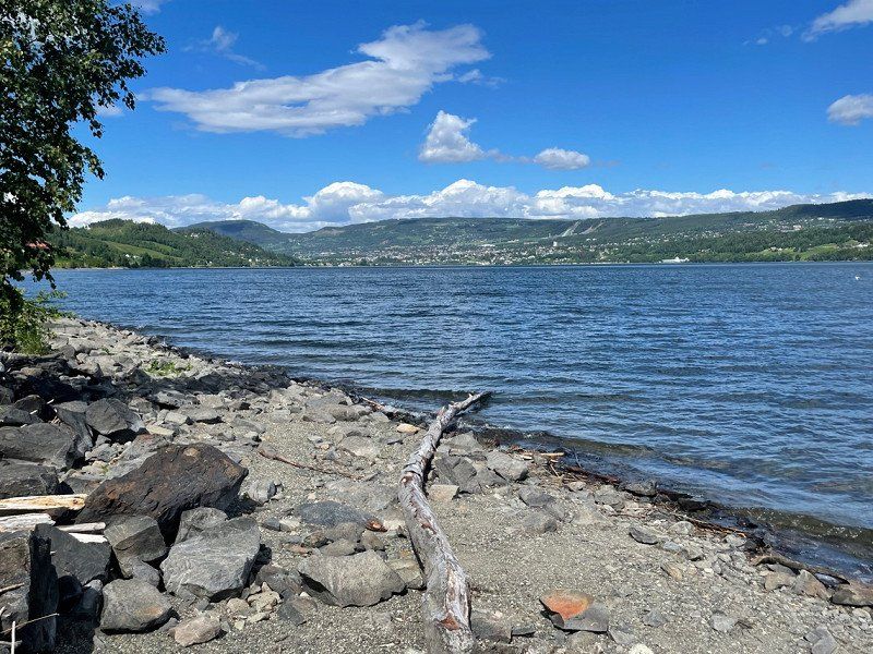
Moseidmoen, Norwegen
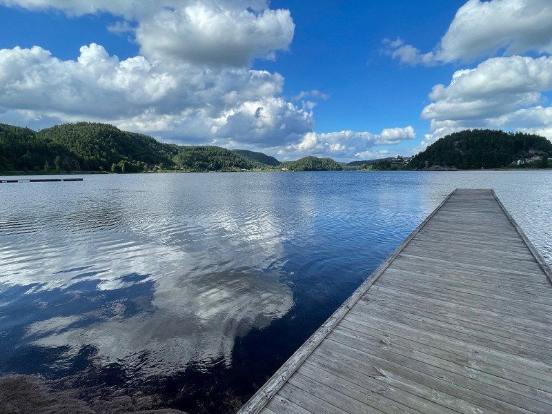
The day before we left we wanted to relax a bit and went to a great lake in Moseidmoen and spent the last night there.
58° 15' 47.2" N 7° 57' 33.5" E
58.2631005 7.9593042
• Head toward Montjønnvegen on Drivenesvegen. Go for 1.3 km.
• Turn right onto Drivenesvegen (405). Go for 4.0 km.
• Turn left onto Torridalsvegen (482). Go for 660 m.
• Continue on Torridalsveien (482). Go for 8.9 km.
• Take the 2nd exit from roundabout onto E18 toward Stavanger/E39/Sentrum. Go for 1.3 km.
• Take ramp toward Evje/Terminalen/E39/Danmark/Terminal. Go for 174 m.
• Take the 2nd exit from roundabout onto Vesterveien toward Stavanger/E39/Danmark. Go for 373 m.
• Take the 3rd exit from roundabout onto Vesterveien toward E39/Danmark. Go for 219 m.
• Turn sharp right. Go for 447 m.
• Take the Kristiansand-Hirtshals Ferry. Stay on for 139 km.
• Head southeast on E39. Go for 1.1 km.
• Turn left onto Willemoesvej toward Østhavn. Go for 93 m.
• Turn left onto Willemoesvej toward Hirtshals/Color Line. Go for 23 m.
• Turn right toward Hirtshals/Color Line. Go for 5 m.
• Continue on Willemoesvej toward Hirtshals/Color Line. Go for 26 m.
• Turn left onto Willemoesvej toward Hirtshals/Color Line. Go for 114 m.
• Turn right onto Willemoesvej toward Hirtshals/Color Line. Go for 86 m.
• Turn right onto Aalborgvej (E39) toward Hirtshals/Color Line. Go for 274 m.
• Take ramp onto Jyllandsgade toward Color Line/Terminal/Centrum. Go for 639 m.
• Turn right onto Jyllandsgade. Go for 44 m.
• Continue on Norgeskajen. Go for 379 m.
• Turn right onto Auktionskajen. Go for 24 m.
• Arrive at Auktionskajen. Your destination is on the right.
☍
159,0 km
(4 hrs. 27 min.)
Day
Hirtshals Havn, Norgeskajen, Hirtshals, Dänemark
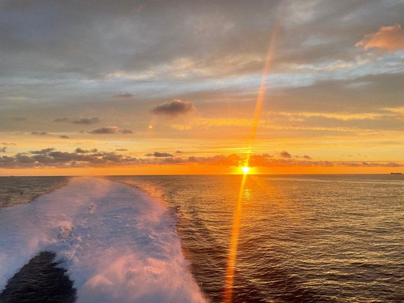
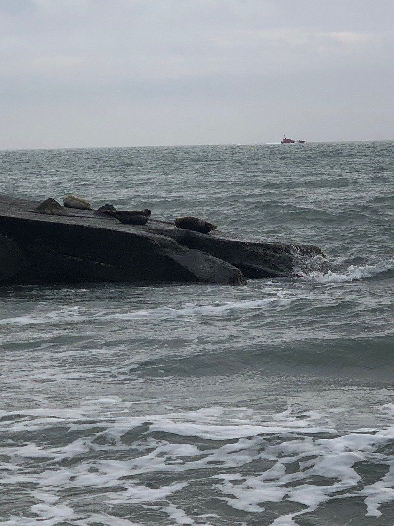
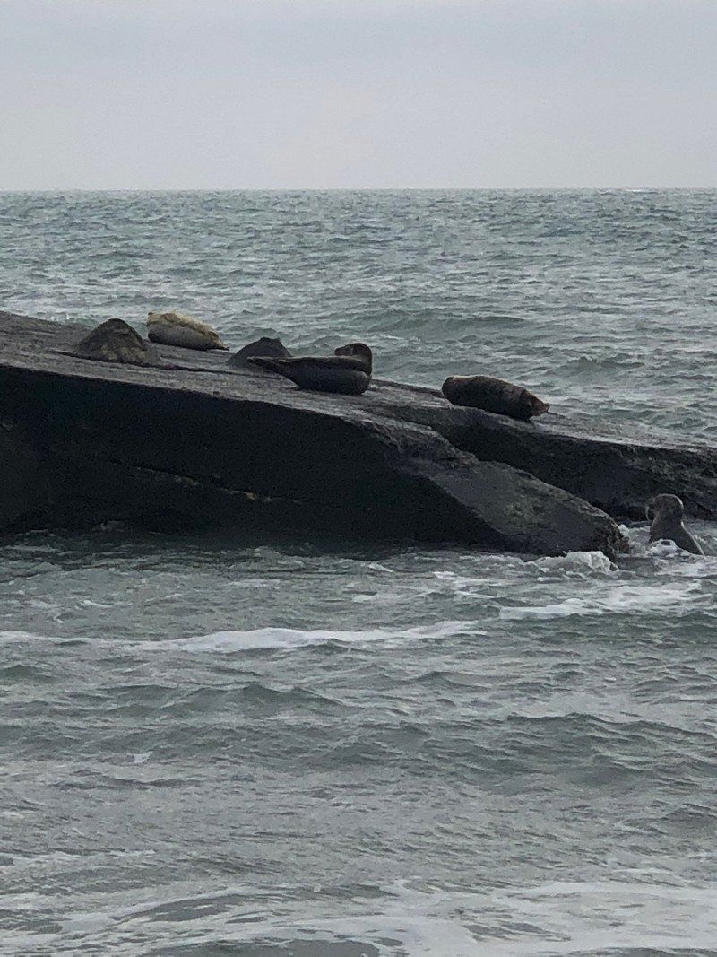
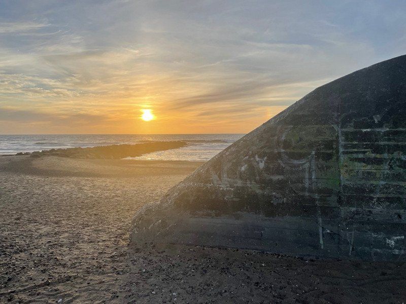
On the last day in Norway we walked a bit through Kristiansand and mentally prepared for the ferry. Unfortunately the ferry left at 8:15 p.m.
Shortly before Hirtshals we watched a fantastic sunset, which we could continue to watch from the parking space at the port.
Norgeskajen 11, 9850 Hirtshals, Dänemark
57° 35' 39.2" N 9° 57' 46.1" E
57.5942361 9.9628099
• Head southeast on Auktionskajen. Go for 24 m.
• Turn left onto Norgeskajen. Go for 379 m.
• Continue on Jyllandsgade. Go for 44 m.
• Turn left onto Jyllandsgade. Go for 324 m.
• Take ramp onto Aalborgvej (E39). Go for 1.6 km.
• Take the 3rd exit from roundabout onto Aalborgvej (E39) toward Aalborg/Skagen/597. Go for 2.3 km.
• Take the 3rd exit from roundabout onto Tverstedvej (597) toward Skagen/Tversted. Go for 10.7 km.
• Take the 2nd exit from roundabout onto Skagensvej (597). Go for 15.4 km.
• Take the 3rd exit from roundabout onto Ålbækvej (40). Go for 6.4 km.
• Take the 2nd exit from roundabout onto Ålbækvej (40). Go for 9.3 km.
• Continue on Frederikshavnsvej (40). Go for 1.7 km.
• Take the 1st exit from roundabout onto Frederikshavnsvej (40). Go for 1.0 km.
• Continue on Christian X's Vej (40). Go for 260 m.
• Turn left onto Trindelvej. Go for 440 m.
• Arrive at Trindelvej. Your destination is on the left.
☍
49,8 km
( 42 min.)
Day
Skagen, Dänemark
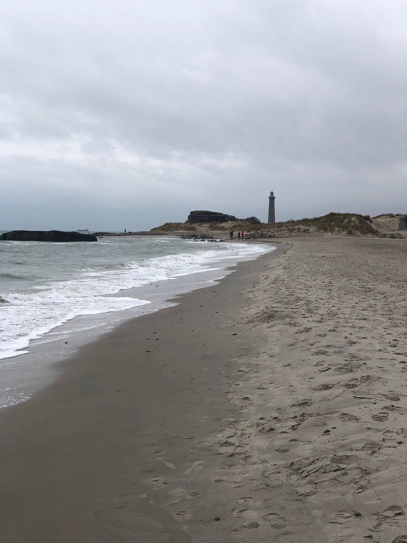
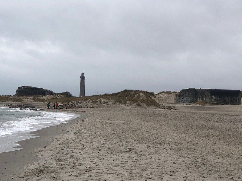
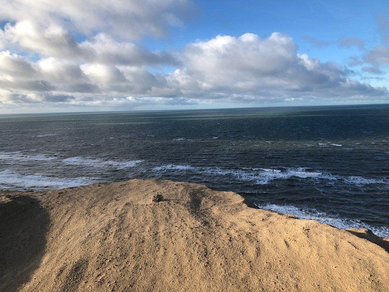
After Hirtshals we wanted to go to Skagen to the point where the North Sea meets the Baltic Sea.
9990 Skagen, Dänemark
57° 43' 30" N 10° 34' 45.1" E
57.7250040 10.5791860
• Head east on Trindelvej. Go for 10 m.
• Turn right onto Trindelvej. Go for 187 m.
• Turn left onto Trindelvej. Go for 250 m.
• Turn right onto Christian X's Vej (40). Go for 1.2 km.
• Pass 2 roundabouts and continue on Ålbækvej (40). Go for 17.4 km.
• Take the 1st exit from roundabout onto Hirtshalsvej (597). Go for 15.3 km.
• Take the 2nd exit from roundabout onto Skagensvej (597). Go for 10.6 km.
• Take the 3rd exit from roundabout onto E39 (Hirtshalsmotorvejen) toward Aalborg. Go for 5.8 km.
• Take exit 2 toward Hjørring N/Bjergby. Go for 447 m.
• Take the 2nd exit from roundabout onto Ringvejen (190) toward Hjørring. Go for 3.4 km.
• Take the 1st exit from roundabout onto Vellingshøjvej. Go for 3.5 km.
• Turn left onto Krustrupvej (55) toward Løkken/Hjørring C/35. Go for 801 m.
• Turn right onto Skallerupvej toward Skallerup Klit/Lønstrup/Sønderlev. Go for 8.4 km.
• Turn right onto Lønstrupvej. Go for 1.5 km.
• Continue on Strandvejen. Go for 562 m.
• Turn left onto Rubjergvej. Go for 2.0 km.
• Turn right. Go for 22 m.
• Turn left. Go for 65 m.
• Arrive at your destination.
☍
71,4 km
(1 hrs. 3 min.)
Day
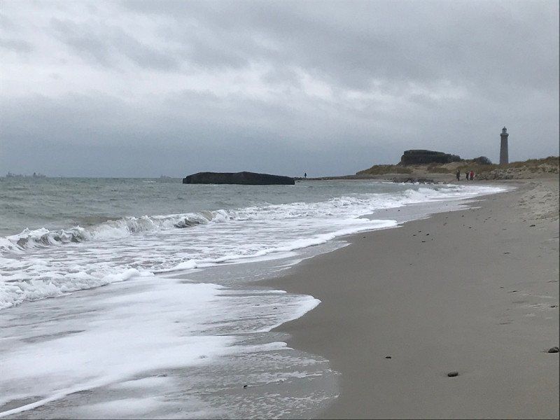
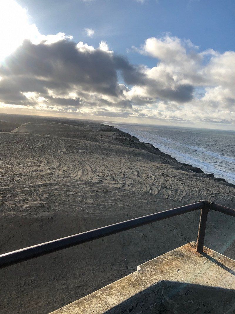
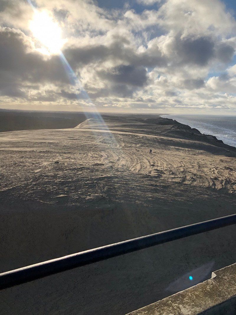
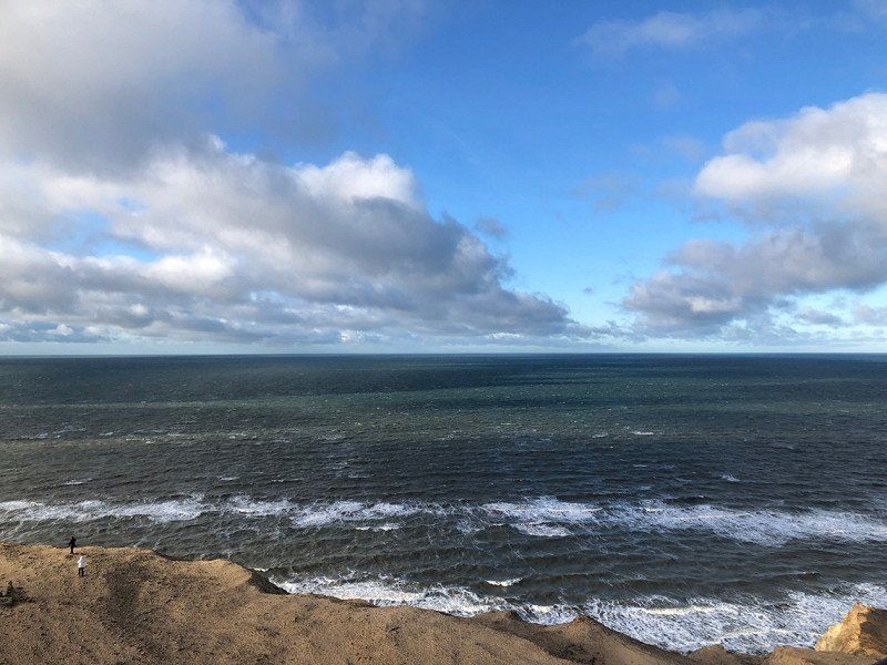
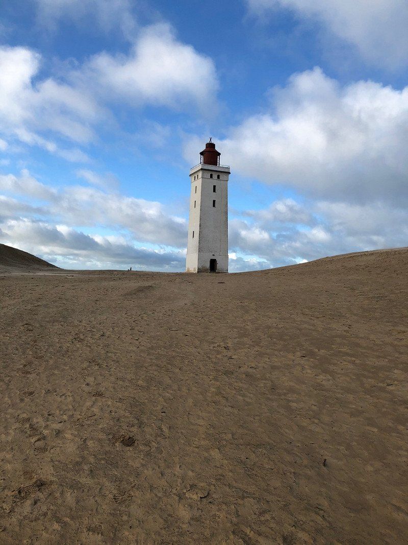
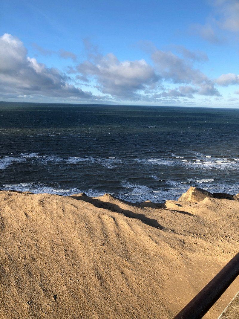
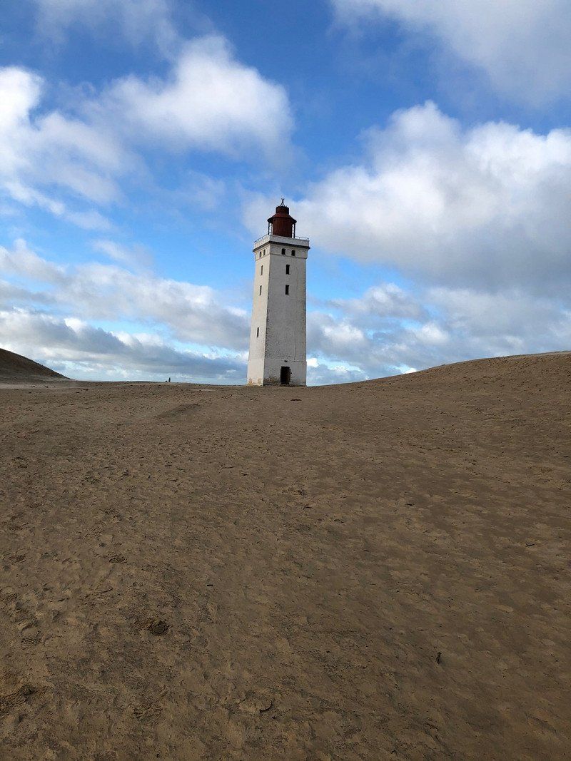
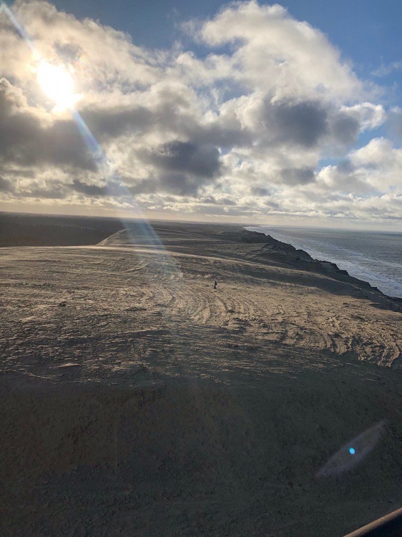
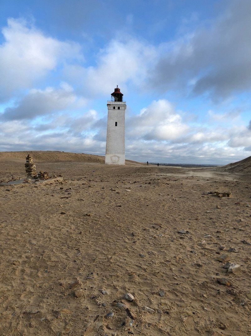
Rubjerg Knude Fyr, Fyrvejen, Løkken, Dänemark
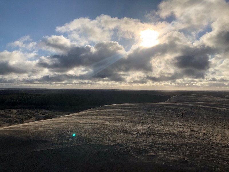
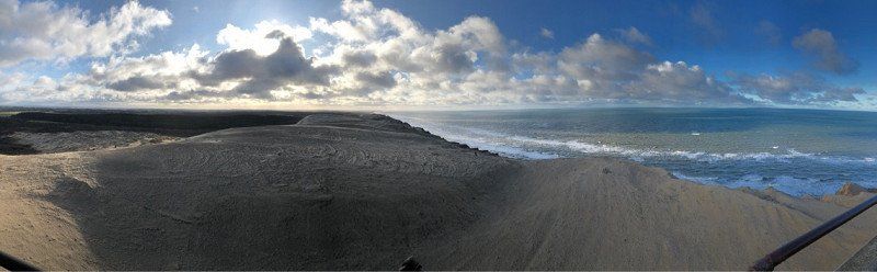
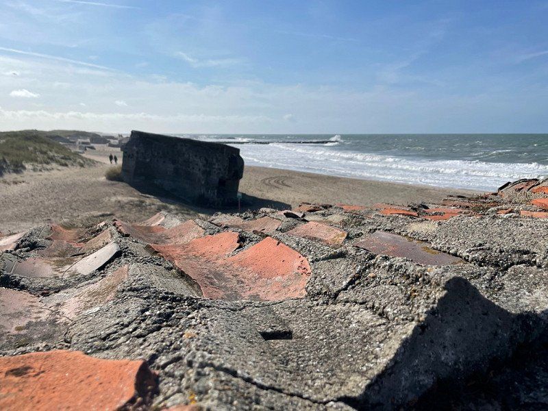
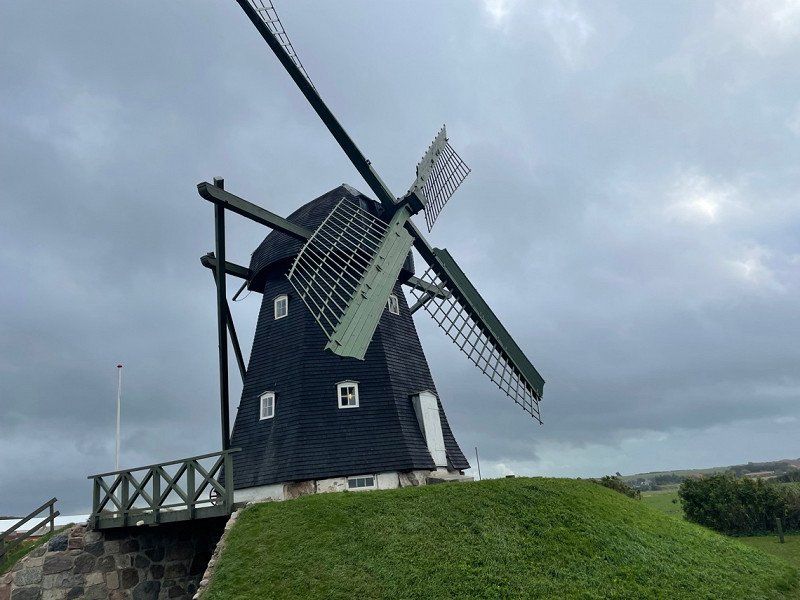
After Skagen we drove to the Rubjerg Knude lighthouse on the shifting dune just before Lønstrup.
This lighthouse was moved inland at great expense in 2019 because it was in danger of falling.
It was very windy there and the sand literally blew around your ears🙈
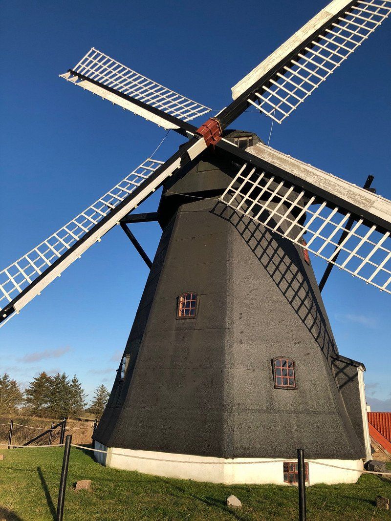
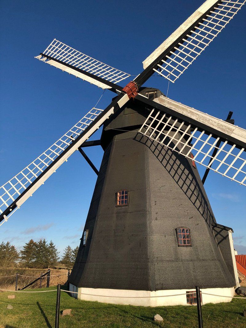
On the way we stopped in Lønstrup for a delicious ice cream and passed a beautiful windmill.
Fyrvejen 110, 9480 Løkken, Dänemark
57° 26' 56.5" N 9° 46' 31.7" E
57.4490318 9.7754810
• Head toward Rubjergvej. Go for 65 m.
• Turn right toward Rubjergvej. Go for 22 m.
• Turn right onto Rubjergvej. Go for 2.3 km.
• Continue on Lønstrupvej. Go for 4.1 km.
• Turn right onto Løkkensvej (55) toward Løkken. Go for 5.8 km.
• Pass 4 roundabouts and continue on Omfartsvejen (55). Go for 24.3 km.
• Turn right onto Gammel Landevej. Go for 1.3 km.
• Continue on Sandmosevej. Go for 17 m.
• Continue on Gammel Landevej. Go for 1.2 km.
• Take the 1st exit from roundabout onto Tranumvej. Go for 4.8 km.
• Continue on Tranum Engevej. Go for 2.1 km.
• Take the 2nd exit from roundabout onto Tranum Engevej. Go for 5.0 km.
• Continue on Dybdalsvej. Go for 1.3 km.
• Continue on Drosselvej. Go for 12 m.
• Continue on Dybdalsvej. Go for 898 m.
• Take the 2nd exit from roundabout onto Hjortdalvej. Go for 3.5 km.
• Turn left onto Bonderupvej. Go for 2.0 km.
• Continue on Mellemmøllevej. Go for 792 m.
• Turn right onto Ålborgvej (11). Go for 29.1 km.
• Pass 2 roundabouts and continue on Oddesundvej (11/26). Go for 26.3 km.
• Take the 1st exit from roundabout onto Oddesundvej (11/26) toward Holstebro/Nykøbing. Go for 13.8 km.
• Turn right onto Vestervigvej (527) toward Agger/Vestervig/Bedsted. Go for 14.8 km.
• Continue on Klostergade (527). Go for 1.4 km.
• Turn right onto Vestergade. Go for 181 m.
• Arrive at Vestergade. Your destination is on the left.
☍
145,2 km
(2 hrs. )
Day
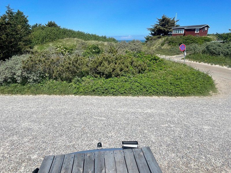
Vestervig, Dänemark
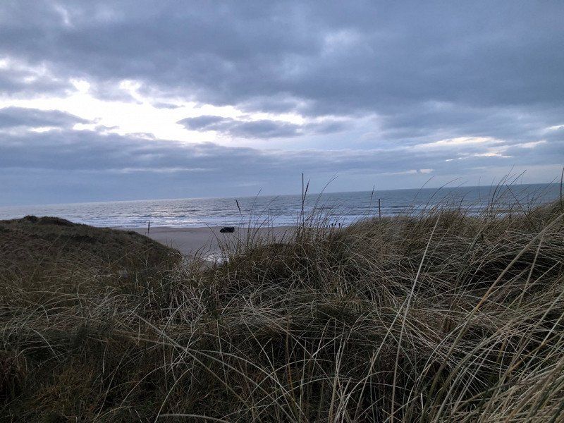
Our next stop in Denmark was Vestervig and the Thy National Park
7770 Vestervig, Dänemark
56° 45' 45.2" N 8° 19' 3.8" E
56.7625660 8.3177160