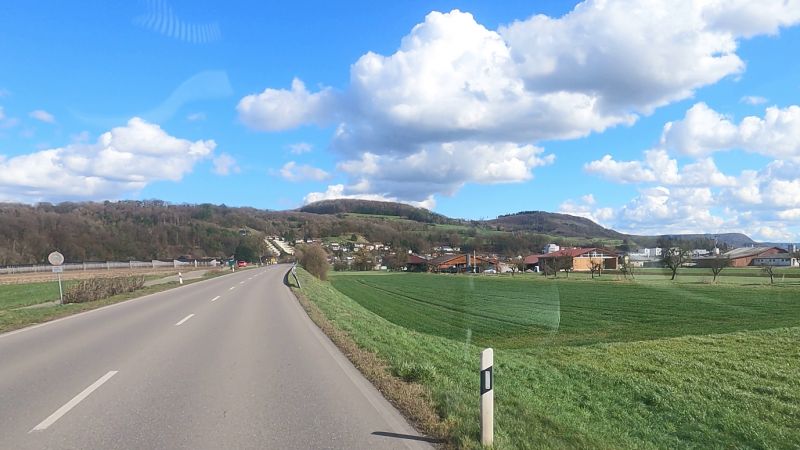
Dangstetten, Küssaberg, Deutschland
Our Spain tour to the Costa Brava starts on February 5th, 2026.
Dangstetten, 79790 Küssaberg, Deutschland
47° 35' 47.5" N 8° 19' 15.9" E
47.5965372 8.3210709
• Head toward Küßnacher Straße on Küferweg. Go for 63 m.
• Turn sharp right onto Küßnacher Straße (L162). Go for 1.5 km.
• Take the 2nd exit from roundabout onto Zurzacher Straße (L162). Go for 592 m.
• Continue toward Zürcherstrasse. Go for 59 m.
• Continue on Zürcherstrasse. Go for 27 m.
• Turn right onto Zürcherstrasse. Go for 176 m.
• Turn left onto Ostumfahrung Zurzach. Go for 720 m.
• Continue on Bruggerstrasse. Go for 1.6 km.
• Continue on Zurzibergstrasse. Go for 1.4 km.
• Take the 2nd exit from roundabout onto Zurzibergstrasse. Go for 544 m.
• Turn right onto Staltig. Go for 225 m.
• Continue on Steig. Go for 262 m.
• Continue on Würenlingerstrasse. Go for 2.9 km.
• Continue on Tegerfelderstrasse. Go for 1.4 km.
• Continue on Breitenstrasse. Go for 860 m.
• Continue on Siggenthalerstrasse. Go for 180 m.
• Take the 2nd exit from roundabout onto Siggenthalerstrasse. Go for 699 m.
• Turn left onto Döttingerstrasse (5). Go for 386 m.
• Turn right onto Stillistrasse (5) toward Bern/Luzern/Aarau/Brugg/Hard. Go for 2.8 km.
• Take the 2nd exit from roundabout onto Zurzacherstrasse (5). Go for 2.0 km.
• Turn left onto Aarauerstrasse (3/5). Go for 491 m.
• Turn left onto Badenerstrasse (3). Go for 201 m.
• Take the 2nd exit from roundabout onto Zürcherstrasse (3). Go for 440 m.
• Take the 1st exit from roundabout onto Hauserstrasse. Go for 631 m.
• Take the 2nd exit from roundabout onto Hauserstrasse. Go for 521 m.
• Take the 2nd exit from roundabout onto Zubringer Hausen. Go for 278 m.
• Take ramp onto Zubringer Hausen. Go for 2.0 km.
• Continue on Lenzburgerstrasse. Go for 3.4 km.
• Take the 3rd exit from roundabout onto A1 toward Bern. Go for 37.2 km.
• Continue on A1 (Härkingen) toward E25/Lausanne/Bern/Biel/Bienne/Oensingen. Go for 50.8 km.
• Take the exit toward Lausanne/Fribourg/Neuchâtel/Bern-Neufeld onto A1 (Wankdorf). Go for 99.8 km.
• Continue on A1. Go for 2.7 km.
• Take the exit toward Genève onto A1. Go for 65.2 km.
• Continue on A41. Go for 37.8 km.
• Take exit 15.1 toward Seynod-Sud/Chapeiry. Go for 1.2 km.
• Take the 1st exit from roundabout onto Route des Godets (D38) toward Chapeiry. Go for 337 m.
• Turn right onto Chemin des Godes. Go for 15 m.
• Turn slightly left onto Chemin des Godes. Go for 550 m.
• Turn slightly left onto Chemin des Godes. Go for 236 m.
• Turn left onto Route des Godes. Go for 524 m.
• Continue on Lieu-dit Laydevant. Go for 113 m.
• Continue on Route des Godes. Go for 364 m.
• Continue on Lieu-dit Domini. Go for 419 m.
• Turn left onto D170. Go for 146 m.
• Continue on Place de la Mairie (D170). Go for 42 m.
• Turn left onto Impasse des Côtes. Go for 52 m.
• Arrive at Impasse des Côtes. Your destination is on the left.
☍
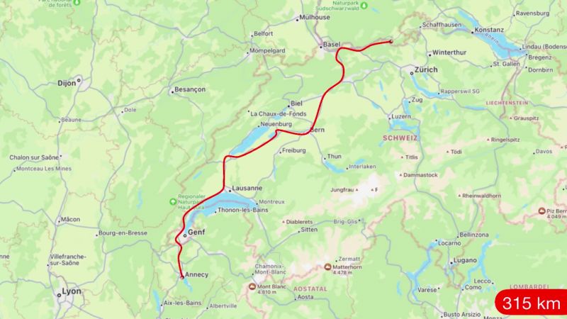
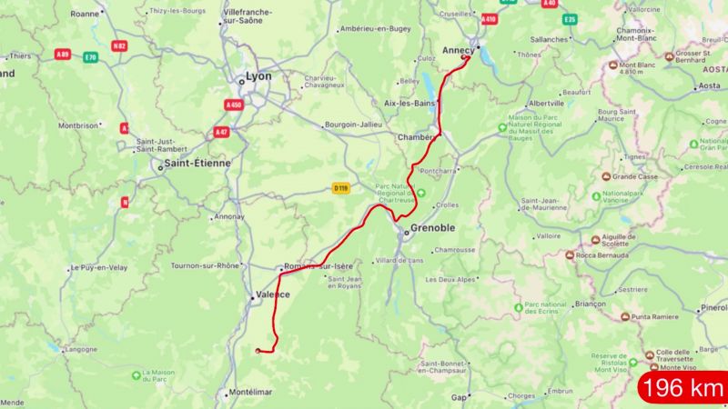
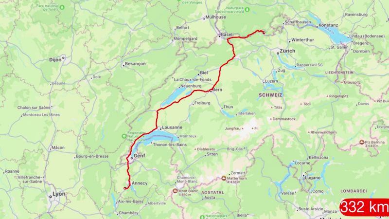
323,9 km
(3 hrs. 16 min.)
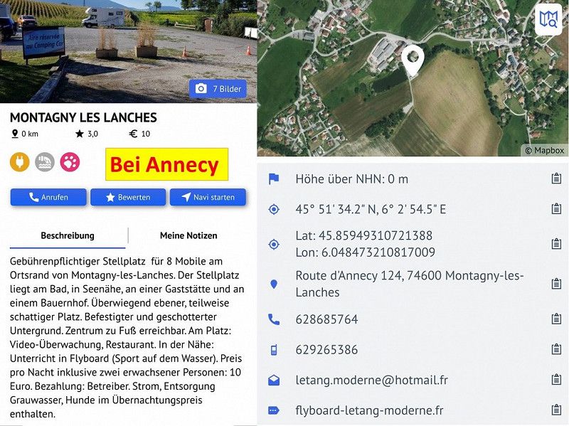
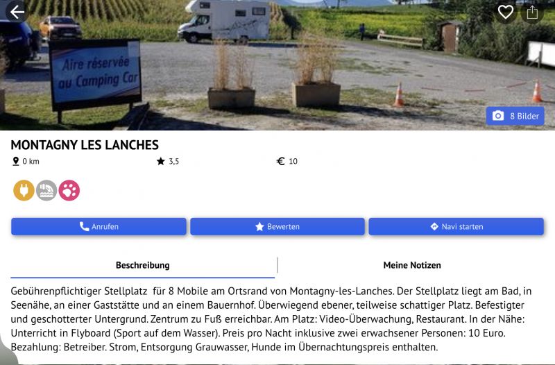
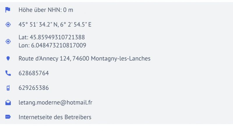
Montagny-les-Lanches, Frankreich
74600 Montagny-les-Lanches, Frankreich
45° 51' 43.3" N 6° 2' 43.9" E
45.8620329 6.0455360
• Head southwest on Impasse des Côtes. Go for 19 m.
• Turn right onto Place de la Mairie (D170). Go for 75 m.
• Continue on D170. Go for 146 m.
• Turn right onto Route des Godes. Go for 419 m.
• Continue on Route des Godes. Go for 364 m.
• Continue on Lieu-dit Laydevant. Go for 113 m.
• Continue on Route des Godes. Go for 524 m.
• Turn right onto Chemin des Godes. Go for 202 m.
• Continue on Chemin des Godes. Go for 599 m.
• Turn left onto Route des Godets (D38). Go for 309 m.
• Take the 4th exit from roundabout onto A41 toward Lyon/Chambéry/Aix les Bains. Go for 34.6 km.
• Continue on A43. Go for 46.9 km.
• Take the exit toward Marseille/Valence/Grenoble onto A48. Go for 42.0 km.
• Take the exit toward Marseille/Valence onto A49. Go for 60.7 km.
• Continue on N532. Go for 10.5 km.
• Take ramp onto N7 toward A7/Lyon/Valence-Centre/Bourg-lès-V/Valence-les Couleures. Go for 2.2 km.
• Keep left onto N7. Go for 2.2 km.
• Take the 3rd exit from roundabout onto Montée du Long (N7) toward Lyon/St Étienne/Pont de l'Isère/Tain l'Hermitage. Go for 4.1 km.
• Turn right onto Rue du Stade toward D220/La Roche de Glun. Go for 52 m.
• Turn right onto Rue des Îles. Go for 482 m.
• Continue on Avenue du Canal toward D220/La Roche de Glun. Go for 236 m.
• Take the 2nd exit from roundabout onto Avenue du Canal. Go for 2.0 km.
• Take the 2nd exit from roundabout onto Avenue du Vercors (D220 A) toward D220/La Roche de Glun/Tain l'Hermitage/Z.A. Croix des Marais/Z.A. de l'Île Neuve. Go for 670 m.
• Take the 2nd exit from roundabout onto Rue des Cévennes (D220 A). Go for 387 m.
• Take the 3rd exit from roundabout onto Rue de Crussol. Go for 235 m.
• Continue on Rue de Crussol. Go for 244 m.
• Arrive at Rue de Crussol. Your destination is on the left.
☍
210,2 km
(1 hrs. 55 min.)
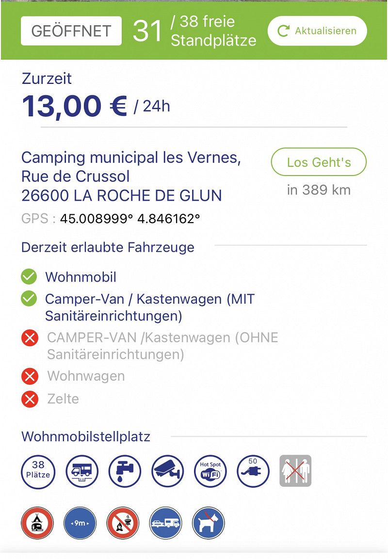
Camping Municipal Les Vernes
26600, La Roche De Glun, France
45° 0' 26.6" N 4° 50' 55" E
45.0074000 4.8486000
• Head toward Chemin de Saint-Jean on Rue de Crussol. Go for 244 m.
• Continue on Rue de Crussol. Go for 198 m.
• Take the 1st exit from roundabout onto Rue des Cévennes (D220 A). Go for 377 m.
• Take the 2nd exit from roundabout onto Avenue du Vercors (D220 A). Go for 640 m.
• Take the 1st exit from roundabout toward D220/Pont de l'Isère/Z.I. les Serres. Go for 748 m.
• Continue on Avenue du Canal. Go for 1.3 km.
• Take the 1st exit from roundabout onto Avenue du Canal. Go for 249 m.
• Turn left onto Rue du Stade toward D220/Valence. Go for 280 m.
• Turn right onto N7. Go for 4.0 km.
• Take the 6th exit from roundabout toward Marseille/Avignon/Montélimar/St Étienne/Lyon. Go for 525 m.
• Take ramp onto A7 (Autoroute du Soleil) toward Marseille/Avignon/Montélimar. Go for 102 km.
• Take exit 21 toward Orange-Centre/Caderousse. Go for 1.5 km.
• Take the 4th exit from roundabout onto Route de Caderousse (D17) toward Caderousse. Go for 295 m.
• Take the 2nd exit from roundabout onto Route de Caderousse (D17). Go for 617 m.
• Continue on D17. Go for 2.7 km.
• Continue on Lieu-dit Le Chemin d'Orange (D17). Go for 153 m.
• Continue on D17. Go for 559 m.
• Continue on Lieu-dit le moulin (D17). Go for 175 m.
• Continue on D17. Go for 197 m.
• Continue on Lieu-dit Bayard (D17). Go for 83 m.
• Continue on Route d'Orange (D17). Go for 801 m.
• Take the 3rd exit from roundabout onto Route de Châteauneuf (D17). Go for 53 m.
• Turn right onto D17 A. Go for 456 m.
• Continue on D237. Go for 925 m.
• Continue on Lieu-dit Les Islons (D237). Go for 633 m.
• Continue on D237. Go for 1.3 km.
• Take the 2nd exit from roundabout onto D238. Go for 3.4 km.
• Continue on D138 A. Go for 2.5 km.
• Take the 3rd exit from roundabout onto D138 B. Go for 765 m.
• Keep left onto Rue Frédéric Mistral (D765). Go for 1.0 km.
• Arrive at Rue Frédéric Mistral (D765). Your destination is on the right.
☍
129,1 km
(1 hrs. 19 min.)
Codolet
Rue Frédéric Mistral 39, Codolet, Bagnols-sur-Cèze, Département Gard, Frankreich
44° 7' 35" N 4° 42' 5.1" E
44.1264000 4.7014100
• Head toward Rue du Pont on Rue Frédéric Mistral (D765). Go for 32 m.
• Take the 1st exit from roundabout onto Rue Frédéric Mistral (D765). Go for 230 m.
• Take the 1st exit from roundabout onto Rue Frédéric Mistral (D765). Go for 420 m.
• Continue on D765. Go for 768 m.
• Continue on Route des Compagnons (D765). Go for 189 m.
• Turn left onto N580. Go for 2.5 km.
• Take the 1st exit from roundabout onto N580. Go for 230 m.
• Take the 2nd exit from roundabout onto N580 toward A9/Avignon/Roquemaure/St Laurent des A./P.R.A.E. Lavoisier. Go for 1.9 km.
• Take the 2nd exit from roundabout onto N580. Go for 3.1 km.
• Take the 2nd exit from roundabout onto N580 toward A9/Avignon/Les Angles. Go for 4.0 km.
• Take the 2nd exit from roundabout onto Échangeur de Roquemaure toward Avignon/Roquemaure/Pujaut/Les Angles/Villeneuve. Go for 498 m.
• Take ramp onto A9 (La Languedocienne) toward Nîmes/Montpellier. Go for 145 km.
• Take the exit toward Valras-Plage/Sérignan/Aéroport Béziers-Cap d'Agde/Béziers-Centre onto A75 (La Méridienne). Go for 1.9 km.
• Take exit 64 toward Sérignan. Go for 1.7 km.
• Take the 2nd exit from Rond-Point des Étoiles roundabout toward Sérignan/Villeneuve lès B./Aéroport Béziers Cap d'Agde/Béziers-Gare/Béziers-la Devèze. Go for 193 m.
• Take the 2nd exit from Rond-Point du 9 Mai roundabout onto D612 toward Valras Plage/Sérignan/Villeneuve lès B./Aéroport Béziers-Cap d'Agde. Go for 2.0 km.
• Take the 2nd exit from Rond-Point de la Méditerranée roundabout onto Route de Sérignan (D64) toward Sérignan/Valras-Plage. Go for 4.2 km.
• Take ramp. Go for 386 m.
• Take the 2nd exit from roundabout onto D37 toward Sérignan-Plage. Go for 165 m.
• Take the 1st exit from roundabout onto D37 E11. Go for 2.0 km.
• Turn slightly left toward Lieu-dit Sainte-Denise. Go for 667 m.
• Continue on Lieu-dit Sainte-Denise. Go for 1.0 km.
• Continue on Domaine Sainte-Rita. Go for 127 m.
• Turn right. Go for 22 m.
• Turn right toward Lieu-dit Sainte-Rita. Go for 32 m.
• Continue on Lieu-dit Sainte-Rita. Go for 596 m.
• Turn left onto Allée de la Grande Maire (D37 E11). Go for 333 m.
• Continue on D37 E11. Go for 20 m.
• Continue on Allée de la Grande Maire (D37 E11). Go for 476 m.
• Turn right onto Allée de Beauséjour. Go for 20 m.
• Turn right. Go for 58 m.
• Turn left. Go for 84 m.
• Arrive at your destination on the right.
☍
174,7 km
(1 hrs. 46 min.)
Camping-car Park de Sérignan-les-plages
Hérault, Okzitanien, Frankreich
43° 16' 7.8" N 3° 19' 50.5" E
43.2688336 3.3306902
• Head west. Go for 260 m.
• Turn left onto Allée de Beauséjour. Go for 20 m.
• Turn left onto Allée de la Grande Maire (D37 E11). Go for 476 m.
• Continue on D37 E11. Go for 20 m.
• Continue on Allée de la Grande Maire (D37 E11). Go for 333 m.
• Continue on D37 E11. Go for 1.8 km.
• Turn right. Go for 98 m.
• Turn right toward Chemin de Portiragnes à Sérignan. Go for 2.2 km.
• Turn left onto Chemin de Portiragnes à Sérignan. Go for 896 m.
• Continue on Lieu-dit Les Salans Hauts. Go for 97 m.
• Continue on Chemin de Portiragnes à Sérignan. Go for 150 m.
• Turn left onto Chemin du Grand Salan. Go for 351 m.
• Continue on Chemin du Grand Salan. Go for 49 m.
• Turn left onto Avenue de Béziers (D37). Go for 431 m.
• Continue on Chemin de Béziers (D37). Go for 59 m.
• Continue on Lieu-dit La Prade (D37). Go for 165 m.
• Continue on Chemin de Béziers (D37). Go for 406 m.
• Continue on Route de Portiragnes (D37). Go for 262 m.
• Take ramp onto Route d'Agde (D612). Go for 2.1 km.
• Keep right toward A9/A75/Béziers-Centre/Pézenas. Go for 297 m.
• Continue on Avenue de la Méditerranée (D612). Go for 1.7 km.
• Take ramp toward A75/A9/Clermont-Fd/Montpellier/Narbonne/Pézenas/P.A.E. du Capiscol/P.A.E. la Méridienne. Go for 259 m.
• Take the 2nd exit from Rond-Point des Étoiles roundabout onto A75 (La Méridienne) toward Narbonne/Montpellier. Go for 2.4 km.
• Take the left exit toward Lyon/Montpellier/Sète onto A9 (La Languedocienne). Go for 52.6 km.
• Keep right onto A709 toward Montpellier/Aéroport. Go for 6.5 km.
• Take exit 30 toward Montpellier-Sud/Montpellier-Centre/Lattes/Palavas les Flots onto M986 (Route de Palavas). Go for 5.7 km.
• Take the 2nd exit from roundabout onto Route de Montpellier (M986). Go for 2.5 km.
• Take the 3rd exit from Rond-Point de l'Europe roundabout onto D62 E2. Go for 483 m.
• Take the 1st exit from roundabout onto Avenue de l'Abbé Brocardi. Go for 466 m.
• Turn right onto Quai François Vical. Go for 43 m.
• Continue on Place du Docteur Clément. Go for 107 m.
• Turn left onto Quai Paul Cunq. Go for 236 m.
• Turn left onto Rue Aristide Briand. Go for 29 m.
• Arrive at Rue Aristide Briand. Your destination is on the left.
☍
83,4 km
(1 hrs. 1 min.)
Palavas-les-Flots
Hérault, Okzitanien, Frankreich
43° 31' 40.1" N 3° 55' 53.5" E
43.5278137 3.9315347
• Head toward Rue Saint-Roch on Rue Aristide Briand. Go for 53 m.
• Turn left onto Rue Saint-Pierre. Go for 100 m.
• Turn right onto Rue Saint-Pierre. Go for 39 m.
• Turn right onto Rue Simon. Go for 79 m.
• Turn left onto Avenue de la Gare Albert Dubout. Go for 103 m.
• Turn slightly left onto Place du Docteur Clément. Go for 134 m.
• Turn slightly right onto Quai du Chapitre. Go for 11 m.
• Turn right onto Avenue du Général de Gaulle. Go for 264 m.
• Turn left onto Rue du Prévost. Go for 89 m.
• Turn slightly right onto Rue Guy de Montpellier. Go for 17 m.
• Take the 2nd exit from roundabout onto Boulevard Frédéric Fabrèges. Go for 168 m.
• Take the 2nd exit from Rond-Point de l'Europe roundabout onto Avenue de Lattre de Tassigny (D986). Go for 2.5 km.
• Take the 2nd exit from roundabout onto Route de Palavas (M986). Go for 5.6 km.
• Take ramp onto A709 toward Barcelone/Toulouse/Béziers/Sète. Go for 6.8 km.
• Continue on A9 (La Languedocienne). Go for 40.4 km.
• Take exit 34 toward Pézenas/Agde/Vias/Bessan. Go for 952 m.
• Take the 2nd exit from roundabout onto D13 toward Pézenas/Bessan/Florensac. Go for 304 m.
• Take the 3rd exit from roundabout onto Route de Saint-Thibéry (D13) toward A75/Millau/Clermont-Fd/Montblanc/St Thibery/Florensac/Pézenas. Go for 2.4 km.
• Take ramp onto D18 toward St Thibéry/Montblanc/Servian. Go for 3.9 km.
• Take the 2nd exit from roundabout onto Avenue d'Agde (D18). Go for 3.6 km.
• Take the 2nd exit from roundabout onto D18. Go for 340 m.
• Take the 3rd exit from roundabout onto N9 toward P.A.E. la Baume. Go for 2.0 km.
• Take the 2nd exit from roundabout onto Lieu-dit Le Mas Condat (N9). Go for 126 m.
• Continue on N9. Go for 197 m.
• Continue on Lieu-dit Villa Monplaisir (N9). Go for 149 m.
• Continue on N9. Go for 705 m.
• Continue on Lieu-dit Le Pont de la Baume (N9). Go for 166 m.
• Continue on Route de Pézenas (N9). Go for 543 m.
• Turn left onto Allée de Clairac. Go for 2.4 km.
• Continue straight ahead. Go for 32 m.
• Arrive at your destination on the left.
☍
74,1 km
( 56 min.)
Camping Domaine De Clairac
34500, Beziers, France
43° 21' 45.7" N 3° 19' 10.2" E
43.3627000 3.3195000
• Head toward Allée de Clairac. Go for 32 m.
• Continue on Allée de Clairac. Go for 2.4 km.
• Turn right onto Route de Pézenas (N9). Go for 545 m.
• Continue on Lieu-dit Le Pont de la Baume (N9). Go for 166 m.
• Continue on N9. Go for 1.1 km.
• Take the 2nd exit from roundabout onto N9. Go for 1.9 km.
• Take the 1st exit from roundabout onto A75 (La Méridienne) toward Barcelone/Béziers. Go for 9.5 km.
• Take the exit toward Barcelone/Toulouse/Narbonne/Béziers-Ouest onto A9 (La Languedocienne). Go for 121 km.
• Continue on AP-7 (Autopista de la Mediterrània). Go for 20.3 km.
• Take exit 3 toward Figueres N./Roses/Figueres/Girona/Barcelona/Olot/Ripoll. Go for 391 m.
• Take the 3rd exit from roundabout onto N-2 toward Figueres/Girona/Barcelona. Go for 5.4 km.
• Take ramp onto Carretera de Roses (C-260) toward Roses. Go for 1.6 km.
• Pass 2 roundabouts and continue on C-260. Go for 3.4 km.
• Take the 3rd exit from roundabout onto C-260 toward Castelló d'Empúries/Roses/Cadaqués. Go for 1.9 km.
• Take the 4th exit from roundabout onto C-260 toward Roses/Cadaqués. Go for 1.8 km.
• Take the 4th exit from roundabout onto C-260 toward Empuriabrava/Roses/Cadaqués. Go for 2.0 km.
• Take the 2nd exit from roundabout onto C-260 toward Empuriabrava/Roses/Cadaqués. Go for 897 m.
• Take the 1st exit from roundabout onto Avinguda Tramuntana toward Empuriabrava. Go for 560 m.
• Take the 1st exit from Plaça de la Font roundabout onto Carrer de la Marinada. Go for 968 m.
• Continue on Passatge Carlit. Go for 276 m.
• Take the 2nd exit from roundabout onto Carrer de la Marinada. Go for 391 m.
• Take the 2nd exit from roundabout onto Carrer de la Marinada. Go for 1.1 km.
• Continue on Carrer de la Marinada. Go for 103 m.
• Take the 3rd exit from roundabout onto Avinguda de Fages de Climent. Go for 356 m.
• Keep right onto Avinguda de Fages de Climent. Go for 276 m.
• Take the 1st exit from roundabout onto Carrer Badia. Go for 131 m.
• Take the 1st exit from roundabout onto Carrer Badia. Go for 77 m.
• Turn right onto Carrer Badia. Go for 41 m.
• Arrive at Carrer Badia. Your destination is on the right.
☍
178,9 km
(1 hrs. 50 min.)
Empuriabrava
Oberampurien, Katalonien, Spanien
42° 14' 39.7" N 3° 7' 35.6" E
42.2443515 3.1265510
• Head toward Carrer de Joan Maragall on Carrer Badia. Go for 192 m.
• Turn left onto Carrer de Joan Maragall. Go for 172 m.
• Take the 1st exit from roundabout onto Carrer Salins 1 Linea. Go for 254 m.
• Turn right onto Avinguda Pompeu Fabra. Go for 136 m.
• Take the 1st exit from roundabout onto Avinguda Pompeu Fabra. Go for 112 m.
• Take the 2nd exit from roundabout onto Carrer de la Marinada. Go for 150 m.
• Continue on Carrer de Montgrí. Go for 1.1 km.
• Take the 2nd exit from roundabout onto Carrer de la Marinada. Go for 392 m.
• Take the 2nd exit from roundabout onto Passatge Carlit toward Centre Históric/Roses/Cadaqués/Figueres/AP-7. Go for 300 m.
• Continue on Carrer de la Marinada. Go for 952 m.
• Take the 2nd exit from Plaça de la Font roundabout onto Avinguda Tramuntana toward Roses/Cadaqués/Figueres/AP-7. Go for 610 m.
• Take the 2nd exit from roundabout onto Carretera de Roses (C-260) toward AP-7/Castelló E./Figueres/Girona/Perpinyà. Go for 882 m.
• Take the 2nd exit from roundabout onto C-260 toward AP-7/Figueres/Girona/Perpinyà. Go for 2.0 km.
• Take the 4th exit from roundabout onto Carretera de Sant Miquel de Fluvià (GIV-6216) toward St. Pere Pescador/l'Escala. Go for 297 m.
• Continue on GIV-6216. Go for 6.5 km.
• Continue on Carretera de Sant Miquel de Fluvià (GIV-6216). Go for 278 m.
• Take the 1st exit from roundabout toward Girona/AP-7/Vilamacolum/Torroella de Fluvià. Go for 57 m.
• Turn left onto Carrer de les Delícies toward Girona/AP-7/Torroella de Fluvià/Vilamacolum. Go for 946 m.
• Continue on GIV-6217. Go for 3.6 km.
• Take the 2nd exit from roundabout toward Figueres. Go for 187 m.
• Keep left. Go for 372 m.
• Take the 4th exit from roundabout toward La Bisbal E./Figueres/Torroella F./St. Pere P. Go for 131 m.
• Take ramp onto C-31 toward Torroella de M./La Bisbal E. Go for 14.4 km.
• Take the 3rd exit from roundabout onto Carrer Girona (C-31) toward Torroella de Montgrí/l'Escala. Go for 548 m.
• Continue on C-31. Go for 2.8 km.
• Take the 1st exit from roundabout onto C-31. Go for 1.3 km.
• Continue on Carretera de Torroella de Montgrí a Verges (C-31). Go for 39 m.
• Continue on C-31. Go for 203 m.
• Take the 2nd exit from roundabout onto Carretera de Torroella de Montgrí a Verges (C-31) toward Torroella de Montgrí/Torroella M. Go for 216 m.
• Continue on C-31. Go for 22 m.
• Continue on Carretera de Torroella de Montgrí a Verges (C-31). Go for 94 m.
• Continue on C-31. Go for 72 m.
• Continue on Carretera de Torroella de Montgrí a Verges (C-31). Go for 18 m.
• Continue on C-31. Go for 592 m.
• Take the 2nd exit from roundabout onto Carretera de Sant Jordi (C-31) toward Torroella de Montgrí. Go for 806 m.
• Take the 2nd exit from roundabout onto Avinguda Lluís Companys (C-31) toward l'Estartit/Palafrugell. Go for 504 m.
• Take the 5th exit from Plaça Lledoner roundabout onto Carretera de l'Estartit (GI-641) toward Zona Esportiva/l'Estartit/Illes Medes. Go for 761 m.
• Take the 2nd exit from roundabout onto Carretera de l'Estartit (GI-641) toward Illes Medes/l'Estartit. Go for 534 m.
• Continue on GI-641. Go for 1.6 km.
• Continue on Carretera Torroella (GI-641). Go for 629 m.
• Take the 1st exit from roundabout onto Carretera de Torroella de Montgrí a l'Estartit (GI-641). Go for 981 m.
• Continue on GI-641. Go for 90 m.
• Continue on Carretera de Torroella de Montgrí a l'Estartit (GI-641). Go for 464 m.
• Turn right toward Carrer Freu. Go for 67 m.
• Turn left onto Carrer Freu. Go for 483 m.
• Turn right onto Carrer Devesa. Go for 97 m.
• Turn right. Go for 48 m.
• Turn left. Go for 25 m.
• Turn right. Go for 18 m.
• Arrive at your destination on the right.
☍
46,8 km
( 52 min.)
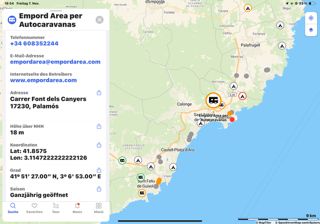
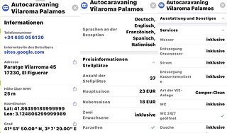
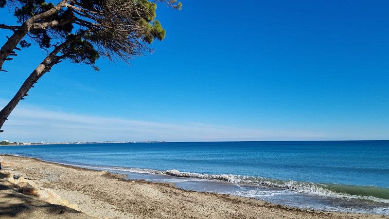
Costa Brava Area
Carrer Devesa 42, Torroella de Montgrí, Niederampurien, Katalonien, Spanien
42° 2' 55.9" N 3° 11' 24.8" E
42.0488664 3.1902136
• Head west. Go for 56 m.
• Turn right toward Carrer Devesa. Go for 142 m.
• Turn left onto Carrer Devesa. Go for 19 m.
• Turn left onto Carrer Garrotxa. Go for 439 m.
• Turn right toward Carretera de Torroella de Montgrí a l'Estartit/GI-641. Go for 157 m.
• Turn left onto Carretera de Torroella de Montgrí a l'Estartit (GI-641). Go for 464 m.
• Continue on GI-641. Go for 90 m.
• Continue on Carretera de Torroella de Montgrí a l'Estartit (GI-641). Go for 937 m.
• Take the 2nd exit from roundabout onto Carretera Torroella (GI-641). Go for 676 m.
• Continue on GI-641. Go for 1.6 km.
• Continue on Carretera de l'Estartit (GI-641). Go for 481 m.
• Take the 2nd exit from roundabout onto Carretera de l'Estartit (GI-641). Go for 703 m.
• Take the 4th exit from Plaça Lledoner roundabout onto Passeig de Catalunya (C-31) toward CAP Hospital/Pals/Palamós. Go for 509 m.
• Take the 2nd exit from roundabout onto Carretera de Palafrugell a Torroella de Montgrí (C-31) toward Palafrugell/La Bisbal d'Empordà/Girona. Go for 340 m.
• Continue on C-31. Go for 233 m.
• Take the 2nd exit from roundabout onto C-31 toward Pals/Palafrugell/Palamós. Go for 7.0 km.
• Continue on Carretera de Palafrugell a Torroella de Montgrí (C-31). Go for 442 m.
• Take the 2nd exit from roundabout onto Carretera de Palafrugell a Torroella de Montgrí (C-31) toward Begur/Palafrugell/Palamós. Go for 1.2 km.
• Take the 2nd exit from roundabout onto GI-652 toward Torrent/Palamós. Go for 798 m.
• Continue on Carretera de Pals (GI-652). Go for 1.8 km.
• Take the 2nd exit from roundabout onto Carretera de Torrent (GI-652). Go for 166 m.
• Continue on GI-652. Go for 671 m.
• Take the 2nd exit from roundabout onto C-66 toward Palafrugell/Mont-Ras/Palamós. Go for 1.8 km.
• Take the 2nd exit from roundabout onto Carretera de Girona a Palamós (C-66) toward Palafrugell/Palamós/Barcelona. Go for 610 m.
• Keep right onto C-31 (Carretera de Girona a Palamós) toward Palafrugell/Palamós/Barcelona. Go for 7.2 km.
• Take exit 326 toward La Fosca/St. Joan de Palamós/Palamós/Hospital. Go for 519 m.
• Take the 4th exit from roundabout toward AP-7/Palamós/St. Joan P./La Fosca. Go for 201 m.
• Keep left toward Palafrugell/La Fosca/Sant Joan de Palamós/Palamós. Go for 469 m.
• Take the 1st exit from roundabout onto Carrer Àngel Guimerà toward Palamós/St. Joan de Palamós. Go for 510 m.
• Take the 2nd exit from roundabout onto Carrer Àngel Guimerà toward Centre Urbà/Estadi. Go for 402 m.
• Continue on Avinguda de la Llibertat. Go for 499 m.
• Continue on Avinguda del President Lluís Companys. Go for 354 m.
• Continue on Avinguda Onze de Setembre toward Centre Ciutat Barri Vell. Go for 28 m.
• Take the 2nd exit from roundabout onto Avinguda Onze de Setembre toward Centre Ciutat Barri Vell. Go for 157 m.
• Turn right onto Carrer Sant Antoni. Go for 103 m.
• Arrive at Carrer Sant Antoni. Your destination is on the left.
☍
31,6 km
( 37 min.)
Palamós
Niederampurien, Katalonien, Spanien
41° 50' 58.3" N 3° 7' 40.4" E
41.8495354 3.1278785
• Head toward Carrer Alba on Carrer Sant Antoni. Go for 222 m.
• Turn right onto Carrer d'Enric Vincke. Go for 152 m.
• Take the 3rd exit from roundabout onto Avinguda Catalunya toward Girona/Barcelona. Go for 313 m.
• Pass 2 roundabouts and continue on Avinguda Catalunya. Go for 452 m.
• Continue on Carrer del Mar. Go for 116 m.
• Take the 1st exit from roundabout onto Riera Aubi (C-256) toward Hospital/Palafrugell/Girona. Go for 307 m.
• Take the 1st exit from roundabout onto Riera Aubi (C-256) toward AP-7/C-31/Girona/Palafrugell/Vall-Llobrega/Sant Joan de Palamós/Hospital. Go for 112 m.
• Continue on C-256. Go for 146 m.
• Take the 3rd exit from roundabout onto C-256 toward Calonge/Platja d'Aro/AP-7. Go for 349 m.
• Take the 2nd exit from roundabout onto C-31 toward Calonge/Platja d'Aro/AP-7. Go for 14.6 km.
• Continue on C-65. Go for 6.3 km.
• Continue on C-35 toward Barcelona/AP-7 sud/Lloret de Mar. Go for 16.5 km.
• Take exit 84A toward Barcelona/N-2 Sud. Go for 556 m.
• Continue on N-2. Go for 9.7 km.
• Take the 3rd exit from roundabout onto GI-600 toward Blanes. Go for 1.9 km.
• Pass 2 roundabouts and continue on Carretera de Tordera (GI-600). Go for 2.6 km.
• Take the 2nd exit from roundabout onto Avinguda d'Europa toward Blanes. Go for 252 m.
• Take the 2nd exit from roundabout onto Avinguda d'Europa. Go for 192 m.
• Take the 3rd exit from roundabout onto Avinguda d'Europa toward Blanes sud. Go for 178 m.
• Take the 2nd exit from roundabout onto Avinguda d'Europa toward Estación F.F.C.C/Platja de s'Abanell/Centre Urbà. Go for 125 m.
• Take the 3rd exit from Avinguda de l'Estació roundabout onto Avinguda d'Europa toward Centre Urbà. Go for 321 m.
• Take the 2nd exit from roundabout onto Avinguda d'Europa toward Platja de s'Abanell. Go for 740 m.
• Continue on Carrer de la Plantera. Go for 107 m.
• Take the 2nd exit from roundabout onto Carrer de Mallorca toward Veïnat els Pins. Go for 187 m.
• Continue on Avinguda del Mediterrani. Go for 103 m.
• Pass 2 roundabouts and continue on Avinguda del Mediterrani. Go for 281 m.
• Turn right onto Avinguda de la Vila de Madrid. Go for 679 m.
• Turn left onto Carrer de Nil Maria Fabra. Go for 21 m.
• Arrive at Carrer de Nil Maria Fabra. Your destination is on the right.
☍
57,5 km
( 50 min.)
Camping Blanes
Avenida Vila de Madrid 33, 17300, Blanes, Spain
41° 39' 33.7" N 2° 46' 47.9" E
41.6593600 2.7799700
• Head toward Carrer de Cristòfor Colom on Carrer de Nil Maria Fabra. Go for 21 m.
• Turn right onto Avinguda de la Vila de Madrid. Go for 86 m.
• Turn right onto Carrer de Mercè Rodoreda. Go for 181 m.
• Turn left onto Passeig de s'Abanell. Go for 576 m.
• Turn left onto Avinguda del Mediterrani. Go for 276 m.
• Pass 2 roundabouts and continue on Avinguda del Mediterrani. Go for 250 m.
• Continue on Carrer de Mallorca. Go for 132 m.
• Take the 2nd exit from roundabout onto Carrer de la Plantera toward AP-7/C-32/N-2. Go for 167 m.
• Continue on Avinguda d'Europa. Go for 679 m.
• Take the 4th exit from roundabout onto Avinguda d'Europa toward AP-7/C-32/N-2. Go for 380 m.
• Pass 4 roundabouts and continue on Avinguda d'Europa. Go for 716 m.
• Take the 2nd exit from roundabout onto Carretera de Tordera (GI-600) toward Hostalric/Girona/Vic. Go for 404 m.
• Take the 2nd exit from roundabout onto Carretera de Tordera (GI-600) toward Tordera/Girona/Barcelona. Go for 2.2 km.
• Take the 3rd exit from roundabout onto C-32 toward Barcelona. Go for 35.5 km.
• Take exit 99 toward Argentona/Granollers/Barcelona/E-15/AP-7 onto C-60 (Autovia Mataró Granollers). Go for 9.4 km.
• Take the exit toward E-15/AP-7/Barcelona/Girona-França/Lleida-Tarragona. Go for 756 m.
• Take the left exit toward Barcelona/Lleida/Tarragona onto AP-7 (Autopista de la Mediterrània). Go for 10.2 km.
• Keep right onto AP-7 (Autopista de la Mediterrània) toward Lleida/E-90/AP-2/Tarragona/Sabadell/C-58/Túnels de Vallvidrera/E-9/Manresa/C-16/Polígon Industrial de Zona Franca/Fira. Go for 144 km.
• Take exit 38 toward C-44/N-340/l'Hospitalet de l'Infant/Móra la Nova. Go for 1.0 km.
• Take the 3rd exit from roundabout onto Carretera Hospitalet Móra la Nova (C-44) toward l'Hospitalet de l'Infant/Castelló/N-340/Amposta. Go for 587 m.
• Take the 3rd exit from roundabout onto Carretera Hospitalet Móra la Nova (C-44) toward N-340. Go for 654 m.
• Take the 3rd exit from roundabout onto Carretera Hospitalet Móra la Nova toward Centre Urbà. Go for 255 m.
• Take the 3rd exit from roundabout onto Carrer de les Escoles. Go for 160 m.
• Arrive at Carrer de les Escoles. Your destination is on the left.
☍
209,1 km
(2 hrs. 5 min.)
l'Hospitalet de l'Infant
Baix Camp, Katalonien, Spanien
40° 59' 35.1" N 0° 55' 21.4" E
40.9930816 0.9226161
• Head toward Carrer Estació on Carrer de les Escoles. Go for 120 m.
• Take the 1st exit from roundabout onto Carretera Hospitalet Móra la Nova. Go for 240 m.
• Take the 3rd exit from roundabout onto Carretera Hospitalet Móra la Nova (C-44) toward N-340/AP-7. Go for 611 m.
• Take the 2nd exit from roundabout onto Carretera Hospitalet Móra la Nova (C-44) toward E-15/AP-7. Go for 499 m.
• Take the 1st exit from roundabout onto A-7 (Autovia de la Mediterrània) toward Cambrils/Tarragona. Go for 8.6 km.
• Take exit 1138 toward Mont-Roig/T-323/Barcelona/N-340/València/Mont-Roig del Camp. Go for 307 m.
• Take the 1st exit from roundabout toward Mont-Roig del Camp. Go for 332 m.
• Continue toward N-340/Tarragona/Castelló. Go for 37 m.
• Take the 1st exit from roundabout onto T-323 toward Tarragona/N-340. Go for 882 m.
• Take the 2nd exit from roundabout toward Mont-Roig Badia. Go for 96 m.
• Continue straight ahead. Go for 20 m.
• Take the 3rd exit from roundabout. Go for 126 m.
• Turn right toward Carrer Poblas. Go for 215 m.
• Turn left onto Carrer Poblas. Go for 144 m.
• Arrive at Carrer Poblas. Your destination is on the right.
☍
12,2 km
( 10 min.)
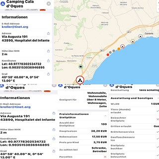
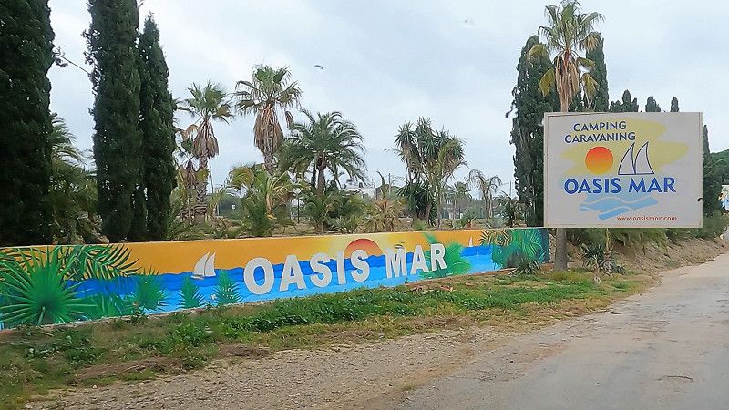
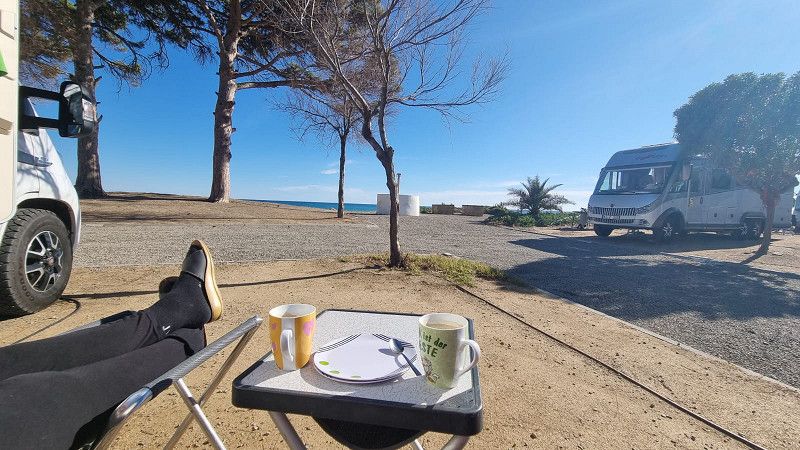
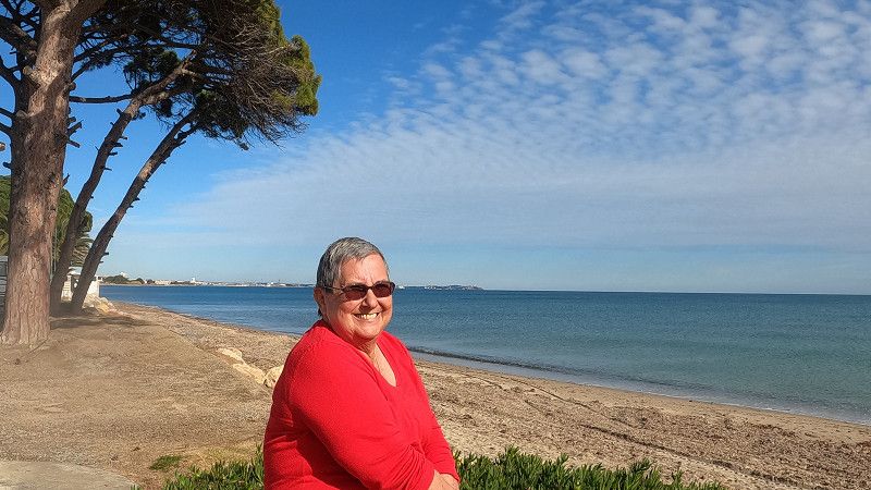
Camping Oasis Mar
Ctra. N-340, Barcelona-Valencia, km.1139, Mont-Roig del Camp, Spain
41° 2' 51.1" N 1° 0' 12.3" E
41.0475300 1.0034300
• Head northwest on Carrer Poblas. Go for 327 m.
• Continue straight ahead. Go for 32 m.
• Turn left. Go for 57 m.
• Continue straight ahead. Go for 23 m.
• Take the 1st exit from roundabout. Go for 58 m.
• Take the 1st exit from roundabout onto N-340 toward Cambrils/Tarragona. Go for 4.8 km.
• Take the 3rd exit from roundabout onto T-312 toward Tarragona/E-15/A-7/Castelló/AP-7/Montbrió del Camp. Go for 993 m.
• Take the 2nd exit from roundabout toward E-15/Tarragona/Barcelona/València. Go for 416 m.
• Take ramp onto AP-7 (Autopista de la Mediterrània) toward Tarragona/Barcelona. Go for 236 km.
• Take exit 4 toward Figueres S/Roses. Go for 1.5 km.
• Continue straight ahead. Go for 29 m.
• Take the 3rd exit from roundabout toward La Jonquera/Perpignan/C-260/Roses/Cadaqués/N-260/Llançà/Centre Duaner Vilamalla. Go for 144 m.
• Continue toward N-2. Go for 165 m.
• Take ramp onto N-2. Go for 5.8 km.
• Take ramp onto Carretera de Roses (C-260) toward Roses/Castelló d'Empúries. Go for 1.1 km.
• Pass 2 roundabouts and continue on C-260. Go for 3.4 km.
• Take the 3rd exit from roundabout onto C-260 toward Castelló d'Empúries/Roses/Cadaqués. Go for 1.9 km.
• Take the 4th exit from roundabout onto C-260 toward Roses/Cadaqués. Go for 1.8 km.
• Take the 4th exit from roundabout onto C-260 toward Empuriabrava/Roses/Cadaqués. Go for 2.0 km.
• Pass 5 roundabouts and continue on Carretera de Besalú a Roses (C-260). Go for 5.5 km.
• Take the 2nd exit from roundabout onto Carrer del Port de Reig. Go for 331 m.
• Turn left onto Carrer dels Falcons. Go for 107 m.
• Turn left. Go for 21 m.
• Arrive at your destination on the left.
☍
266,3 km
(2 hrs. 33 min.)
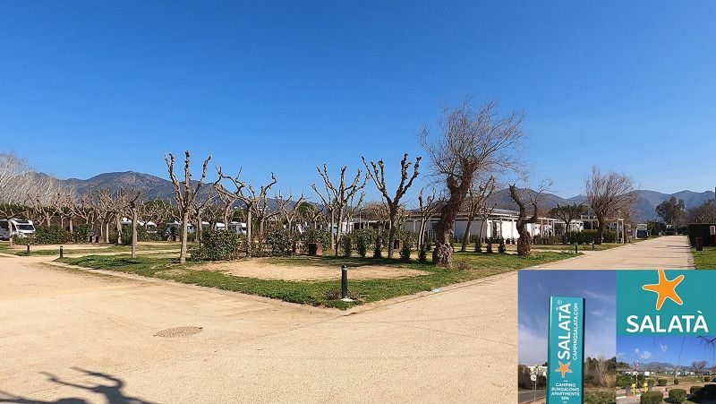
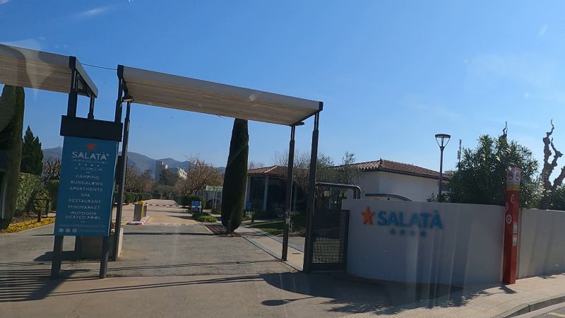
Camping Salatà
Port Reig 44, 17480, Roses, Spain
42° 15' 59.9" N 3° 9' 25.2" E
42.2666405 3.1569936
• Head toward Carrer dels Falcons. Go for 21 m.
• Turn right onto Carrer dels Falcons. Go for 107 m.
• Turn right onto Carrer del Port de Reig. Go for 281 m.
• Take the 3rd exit from roundabout onto Carretera de Besalú a Roses (C-260) toward AP-7/Figueres/Girona/Sta. Margarida. Go for 680 m.
• Take the 3rd exit from roundabout onto Carretera de Besalú a Roses (C-260) toward AP-7/Empuriabrava/Figueres/Girona. Go for 1.1 km.
• Pass 9 roundabouts. Go for 12.7 km.
• Keep left onto C-260. Go for 696 m.
• Take ramp onto Cinturó de Ronda (N-2) toward La Jonquera/Perpinyà. Go for 5.4 km.
• Take ramp onto AP-7 (Autopista de la Mediterrània) toward La Jonquera. Go for 21.8 km.
• Continue on A9 (La Catalane). Go for 114 km.
• Take exit 36 toward Valras-Plage/Vendres/Béziers-Ouest. Go for 996 m.
• Take the 3rd exit from Rond-Point de la Mer roundabout onto D64 toward Vendres/Valras-Plage/Z.A.E Via Europe/Z.A.E. les Vignes-Grandes. Go for 1.1 km.
• Take the 2nd exit from roundabout onto D64. Go for 1.6 km.
• Turn right onto D37. Go for 515 m.
• Continue on Domaine de Bonvoisin (D37). Go for 75 m.
• Continue on Lieu-dit Bonvoisin (D37). Go for 68 m.
• Continue on D37. Go for 154 m.
• Take the 2nd exit from roundabout onto Avenue des Oliviers (D37). Go for 504 m.
• Continue on Avenue des Oliviers (D37). Go for 44 m.
• Continue on Place du 14 Juillet (D37). Go for 69 m.
• Turn right onto Rue Guiraud. Go for 17 m.
• Arrive at Rue Guiraud. Your destination is on the right.
☍
161,5 km
(1 hrs. 33 min.)
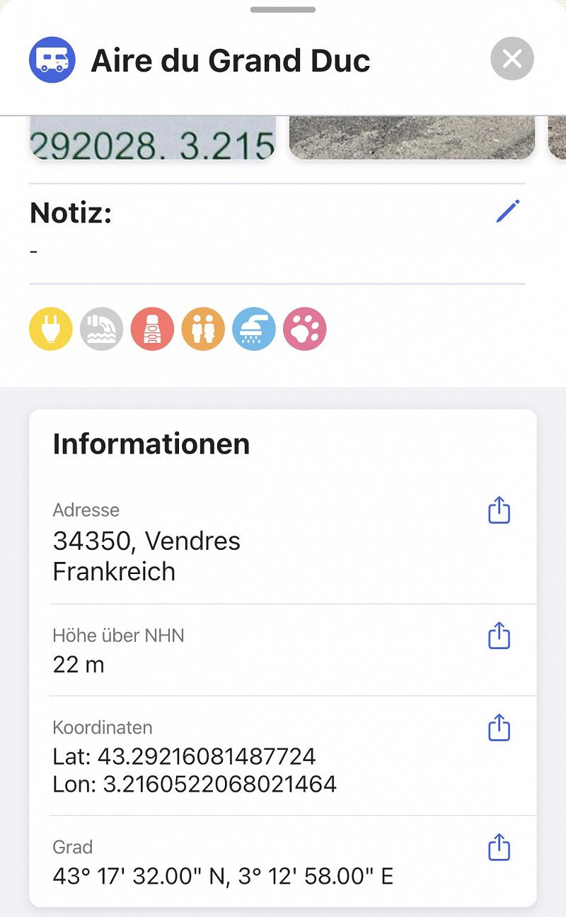
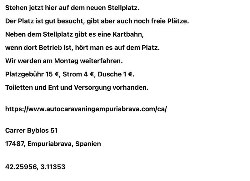
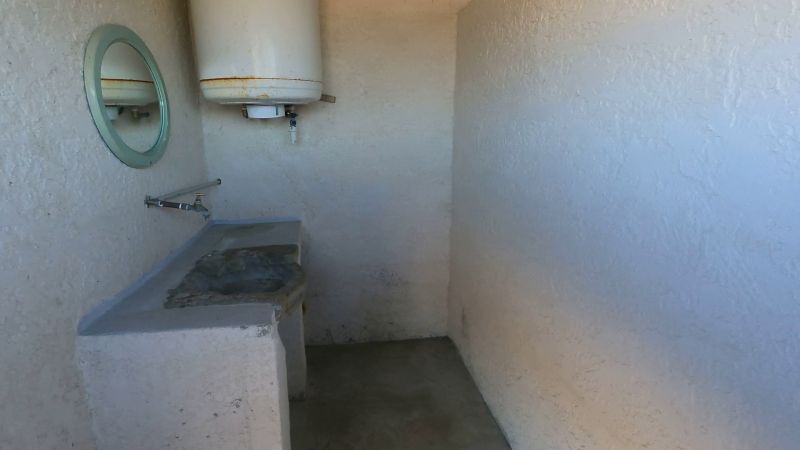
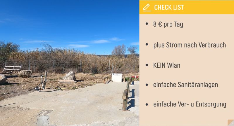
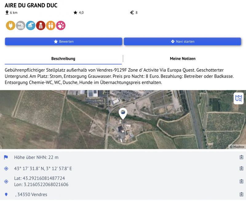
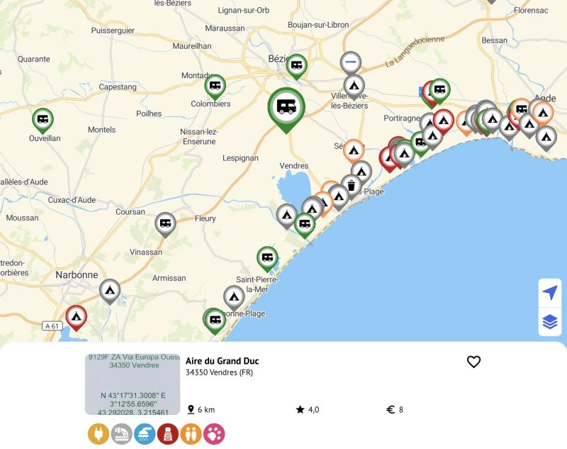
Vendres, Frankreich
Vendres, 34350, Frankreich
43° 16' 7" N 3° 13' 25.3" E
43.2686109 3.2237054
• Head toward Rue de l'Enclos on Rue Guiraud. Go for 31 m.
• Turn left onto Rue de l'Enclos. Go for 32 m.
• Turn left onto Rue de l'Enclos. Go for 19 m.
• Turn left onto Avenue de Valras (D37). Go for 34 m.
• Continue on Place du 14 Juillet (D37). Go for 69 m.
• Continue on Rue du Cers. Go for 43 m.
• Turn right onto Avenue du Languedoc (D37). Go for 31 m.
• Turn left onto Place de la Forge (D37). Go for 467 m.
• Take the 2nd exit from roundabout onto D37. Go for 190 m.
• Continue on Lieu-dit Bonvoisin (D37). Go for 68 m.
• Continue on Domaine de Bonvoisin (D37). Go for 75 m.
• Continue on D37. Go for 458 m.
• Turn left onto D64. Go for 1.6 km.
• Take the 2nd exit from roundabout onto D64. Go for 1.0 km.
• Keep right toward La Languedocienne/A9. Go for 149 m.
• Take ramp onto A9 (La Languedocienne) toward Sète/Montpellier/Lyon. Go for 168 km.
• Continue on A7 (Autoroute du Soleil). Go for 74.1 km.
• Take exit 16 toward Privas/Crest/La Voulte/Livron/Loriol. Go for 882 m.
• Take the 3rd exit from roundabout onto D104 N toward Loriol/Livron/Crest/Die. Go for 736 m.
• Take the 2nd exit from roundabout onto D104 N toward Loriol-Centre. Go for 1.6 km.
• Turn left onto Boulevard Frédéric Mistral (N7) toward Valence/Livron/Crest/Die. Go for 2.1 km.
• Take the 2nd exit from roundabout onto D104 A toward Grâne/Crest/Le Jardin aux Oiseaux. Go for 1.1 km.
• Continue on D104. Go for 6.2 km.
• Turn right onto D437. Go for 460 m.
• Continue on D437. Go for 62 m.
• Turn left onto Grande Rue (D437). Go for 390 m.
• Turn right onto Route de Crest (D437). Go for 174 m.
• Arrive at Route de Crest (D437). Your destination is on the left.
☍
260,2 km
(2 hrs. 17 min.)
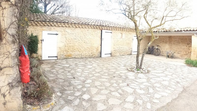
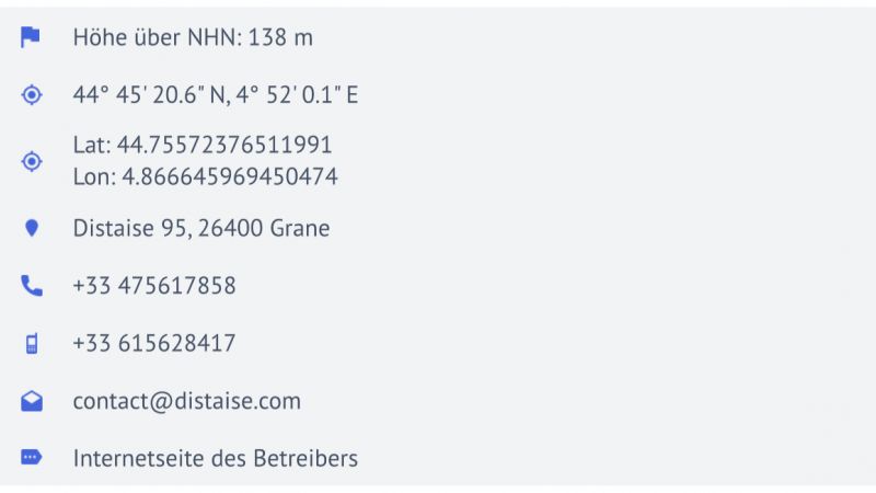
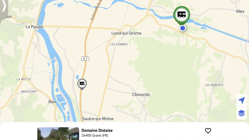
Grane, Frankreich
Grane, 26400, Frankreich
44° 43' 53.4" N 4° 55' 35.4" E
44.7315000 4.9265000
• Head east on Route de Crest (D437). Go for 565 m.
• Turn left onto Chemin des Mattes. Go for 73 m.
• Turn left onto D104. Go for 1.1 km.
• Take the 2nd exit from roundabout onto D125 toward Allex. Go for 3.1 km.
• Turn left onto D93 toward Fiancey/Montoison/Zone Artisanale/Jardin aux Oiseaux. Go for 626 m.
• Take the 2nd exit from roundabout onto Lieu-dit Mouret (D93) toward Fiancey/Valence/Jardin aux Oiseaux/Montoison. Go for 559 m.
• Take the 3rd exit from roundabout onto Impasse des Fanges (D555) toward Ambonil. Go for 726 m.
• Continue on Lieu-dit Ferme de Grange Neuve (D555). Go for 95 m.
• Continue on Lieu-dit Les Fanges (D555). Go for 203 m.
• Continue on D555. Go for 394 m.
• Continue on Lieu-dit Bonnardel (D555). Go for 196 m.
• Continue on D555. Go for 1.2 km.
• Continue on Route d'Allex (D555). Go for 239 m.
• Continue on D555. Go for 2.0 km.
• Continue on Route d'Ambonil (D555). Go for 2.1 km.
• Take the 3rd exit from roundabout onto Route de Die (D111). Go for 943 m.
• Pass 2 roundabouts and continue on Route d'Étoile (D111). Go for 3.2 km.
• Take the 1st exit from roundabout onto Route des Mernes (D269) toward Z.A. de Clairac/Z.A. de Beauvert/Les Mernes. Go for 1.1 km.
• Continue on D269. Go for 2.0 km.
• Take the 3rd exit from roundabout onto Route de Montéléger (D261) toward Valence. Go for 1.8 km.
• Take the 2nd exit from roundabout onto Route de Montéléger (D261) toward Valence. Go for 976 m.
• Take the 1st exit from roundabout onto N7 toward A49/Romans/Valence-le Haut. Go for 7.3 km.
• Continue on E713. Go for 168 m.
• Continue on N532. Go for 10.6 km.
• Keep left onto A49 toward Genève/Chambéry/Grenoble/Romans-Centre. Go for 60.6 km.
• Take the exit toward Voiron/Lyon/Chambéry/Genève onto A48. Go for 41.8 km.
• Take the exit toward Genève/Chambéry/La Tour du Pin onto A43. Go for 46.8 km.
• Continue on A41 toward Genève/Annecy/Aix les Bains. Go for 33.3 km.
• Take exit 15.1 toward Seynod-Sud/Chapeiry. Go for 861 m.
• Take the 1st exit from roundabout onto Route des Godets (D38) toward Chapeiry. Go for 337 m.
• Turn right onto Chemin des Godes. Go for 15 m.
• Turn slightly left onto Chemin des Godes. Go for 550 m.
• Turn slightly left onto Chemin des Godes. Go for 236 m.
• Turn right onto Route des Vignes. Go for 1.0 km.
• Turn right onto Route des Vignes. Go for 41 m.
• Arrive at Route des Vignes. Your destination is on the left.
☍
226,8 km
(2 hrs. 5 min.)
Montagny-les-Lanches, Frankreich
Montagny-les-Lanches, 74600, Frankreich
45° 51' 36.1" N 6° 3' 10" E
45.8600161 6.0527820
• Head toward Route de la Vidôme on Route des Vignes. Go for 52 m.
• Turn right onto Route d'Annecy (D170). Go for 885 m.
• Continue on Route de Montagny (D170). Go for 599 m.
• Take the 1st exit from Rond-Point du Treige roundabout onto Avenue d'Aix-les-Bains (D1201) toward A41/Chambéry/Alby-sur-Chéran/Rumilly. Go for 2.4 km.
• Take the 1st exit from roundabout onto A41 toward Genève/Annecy. Go for 38.8 km.
• Continue on A1. Go for 64.4 km.
• Take the exit toward Bern/Neuchâtel/Simplon/Gd-St-Bernard/Lausanne-Nord/Lausanne-Crissier onto A1 (Ecublens). Go for 21.7 km.
• Continue on A1 toward Bern/Neuchâtel/Yverdon. Go for 81.0 km.
• Take the left exit toward Zürich/Basel/Biel/Bienne onto A1/A6. Go for 6.0 km.
• Continue on A1. Go for 53.8 km.
• Continue on A1 (Verzweigung Wiggertal) toward Zürich/Aarau/Oftringen/Zofingen. Go for 35.0 km.
• Keep right onto A1/A3 toward Zürich/Wettingen-Ost/Neuenhof. Go for 21 m.
• Take the exit. Go for 165 m.
• Turn left onto Birmenstorferstrasse. Go for 157 m.
• Keep left onto Birmenstorferstrasse. Go for 324 m.
• Turn left onto Mellingerstrasse. Go for 1.9 km.
• Take the 1st exit from roundabout onto Mellingerstrasse. Go for 788 m.
• Turn left onto Wettingerstrasse. Go for 243 m.
• Turn right onto Sonnenbergstrasse. Go for 7 m.
• Turn right onto Ehrendingerstrasse. Go for 2.4 km.
• Continue on Landstrasse. Go for 1.4 km.
• Take the 2nd exit from roundabout onto Landstrasse. Go for 295 m.
• Continue on Kantonsstrasse. Go for 739 m.
• Take the 2nd exit from roundabout onto Surbtalstrasse (17). Go for 125 m.
• Pass 2 roundabouts and continue on Surbtalstrasse (17). Go for 8.8 km.
• Take the 1st exit from roundabout onto Zurzibergstrasse. Go for 590 m.
• Take the 2nd exit from roundabout onto Zurzibergstrasse. Go for 1.4 km.
• Continue on Bruggerstrasse. Go for 1.6 km.
• Continue on Ostumfahrung Zurzach. Go for 720 m.
• Turn right onto Zürcherstrasse. Go for 176 m.
• Turn left onto Zürcherstrasse. Go for 86 m.
• Continue on Zurzacher Straße (L162). Go for 553 m.
• Take the 2nd exit from roundabout onto Dangstetter Straße (L162). Go for 1.6 km.
• Turn sharp left onto Küferweg. Go for 63 m.
• Arrive at Küferweg. Your destination is on the right.
☍
328,6 km
(3 hrs. 16 min.)
Dangstetten, Küssaberg, Deutschland
Dangstetten, 79790 Küssaberg, Deutschland
47° 35' 47.5" N 8° 19' 15.9" E
47.5965372 8.3210709