Stage: Ahrensburg- Ludwigshafen- Ladenburg / Heidelberg-Hambacher Tagebau- Ederstausee- Weltvogelpark Walsrode As part of the return of our AUDI in Ludwigshafen, we combined this with a short trip with the above-mentioned milestones.
Day
Gartenholz, Ahrensburg, Deutschland
Our tour starts here. The first stage leads to Ludwigshafen with a stop. Approx. 600km away.
Gartenholz, 22926 Ahrensburg, Deutschland
53° 41' 18.6" N 10° 14' 41" E
53.6885070 10.2447134
• Head toward Syltring on Gartenholz. Go for 444 m.
• Turn left onto Lübecker Straße (L82). Go for 6.5 km.
• Take ramp onto A1 toward Hamburg. Go for 23.1 km.
• Take the left exit toward Bremen/Hannover/HH-Stillhorn onto A1. Go for 15.2 km.
• Continue on Horster Dreieck toward Hannover/Seevetal-Ramelsloh/A7. Go for 1.7 km.
• Continue on A7. Go for 284 km.
• Take exit 79 toward Marburg/Kassel onto A49 (Südtangente). Go for 86.5 km.
• Take the left exit toward Basel/Frankfurt/Wiesbaden/Gießen onto A5. Go for 111 km.
• Continue on A67 (Darmstädter Kreuz) toward Stuttgart/Mannheim. Go for 34.2 km.
• Take exit 10 toward Saarbrücken/Kaiserslautern/Ludwigshafen/MA-Sandhofen onto A6. Go for 12.0 km.
• Take exit 23 toward Ludwigshafen-Nord/Frankenthal-Zentrum onto B9. Go for 2.5 km.
• Continue on L523. Go for 3.4 km.
• Turn right onto Brunckstraße (K2). Go for 85 m.
• Turn left onto Langgartenstraße (K2). Go for 1.3 km.
• Continue on Weiherstraße (K2). Go for 89 m.
• Turn right onto Strandweg. Go for 234 m.
• Turn left. Go for 591 m.
• Turn left toward Bastenhorstweg. Go for 221 m.
• Continue on Bastenhorstweg. Go for 195 m.
• Continue on Industriestraße. Go for 807 m.
• Arrive at Industriestraße. Your destination is on the left.
☍
584,5 km
(5 hrs. 17 min.)
Audi Ludwigshafen – Scherer Automobil GmbH & Co. KG, Industriestraße 48, Ludwigshafen am Rhein, Deutschland
Park Audi
Industriestraße 48, 67063 Ludwigshafen am Rhein, Deutschland
49° 29' 21.3" N 8° 24' 7.9" E
49.4892600 8.4022040
• Head toward Völklinger Straße on Industriestraße. Go for 1.8 km.
• Continue on Bürgermeister-Grünzweig-Straße. Go for 1.1 km.
• Turn right onto Heinigstraße (K8) toward Mannheim/B44. Go for 187 m.
• Take ramp onto B44 toward Frankfurt/A6/Mannheim. Go for 2.0 km.
• Keep left onto Kurt-Schumacher-Brücke (B44) toward Frankfurt/Groß-Gerau/Weinheim/B38/Hafen 3+4/CC Rosengarten. Go for 565 m.
• Keep right onto I7 toward Weinheim/Univers. Klinikum/Krankenhaus Theresien. Go for 712 m.
• Continue on Kurpfalzkreisel toward Univers. Klinikum Theresien/CC Rosengarten. Go for 81 m.
• Keep right onto Friedrichsring toward Univers. Klinikum Theresien/CC Rosengarten. Go for 315 m.
• Keep right onto Friedrichsring toward Heidelberg/CC-Rosengarten. Go for 830 m.
• Turn left onto Friedrichsplatz. Go for 347 m.
• Turn right onto Augustaanlage. Go for 1.2 km.
• Continue on Wilhelm-Varnholt-Allee (B37) toward Heidelberg/Maimarktgelände/SAP-Arena/Gewerbegebiet Fahrlach. Go for 6.3 km.
• Take exit 4 toward MA-Seckenheim/MA-Friedrichsfeld/Edingen-Neckarhausen. Go for 285 m.
• Turn left onto L597 toward MA-Seckenheim/MA-Friedrichsfeld/Edingen-Neckarhausen/Ladenburg/Ilvesheim/Gewerbegebiete Neu-Edingen/Gewerbegebiete Neckarhausen. Go for 1.1 km.
• Turn right onto L597. Go for 175 m.
• Continue on Seckenheimer Hauptstraße (L637) toward Edingen-Neckarhausen/Gewerbegebiet Neu-Edingen/Gewerbegebiet Edingen-Nord. Go for 3.4 km.
• Turn left. Go for 28 m.
• Arrive at your destination on the left.
☍
20,4 km
( 25 min.)
Heidelberger Straße
It was getting late and in Ladenburg we had no luck getting another SP. So we headed for the parking lot at the Cevos restaurant for one night.
Only allowed for cars but there was no other option
49° 26' 38.9" N 8° 37' 9.2" E
49.4441357 8.6192285
• Head toward Hauptstraße. Go for 88 m.
• Turn right onto Hauptstraße (L637). Go for 941 m.
• Continue on Mannheimer Straße (L637). Go for 2.5 km.
• Turn right onto L637 toward Ladenburg/Ilvesheim/MA-Seckenh./MA-Zentrum/Gewerbegebiet Neckarh.-Nord. Go for 1.4 km.
• Turn right onto Brückenstraße (L542) toward Ladenburg/Ilvesheim. Go for 545 m.
• Take the 3rd exit from roundabout onto Schloßstraße (L542) toward Schriesheim/Ladenburg. Go for 2.8 km.
• Turn right onto Ilvesheimer Straße toward Altstadt/Zentrum. Go for 503 m.
• Continue on Bahnhofstraße. Go for 435 m.
• Turn right onto Dr.-Carl-Benz-Platz (L597). Go for 679 m.
• Turn left onto Valentinianstraße. Go for 370 m.
• Turn right onto Vespasianstraße. Go for 126 m.
• Turn right onto Heidelberger Straße. Go for 174 m.
• Turn right onto Heidelberger Straße. Go for 47 m.
• Arrive at Heidelberger Straße. Your destination is on the left.
☍
10,7 km
( 16 min.)
Day
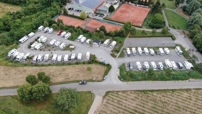
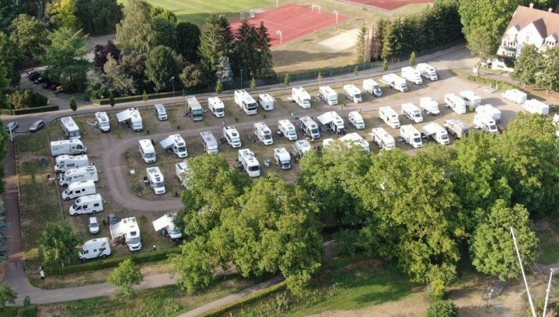
Wohnmobilstellplatz Ladenburg
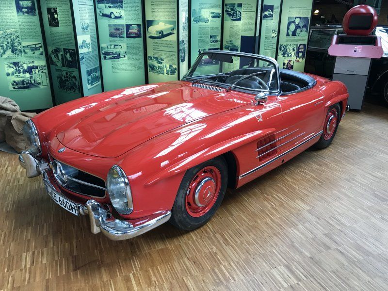
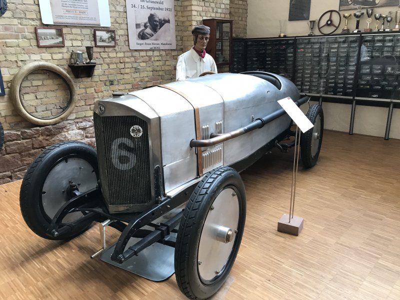
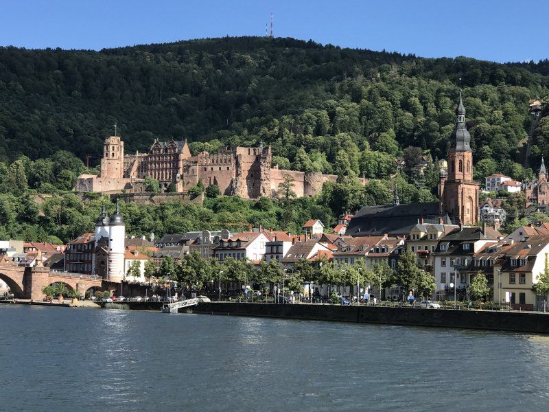
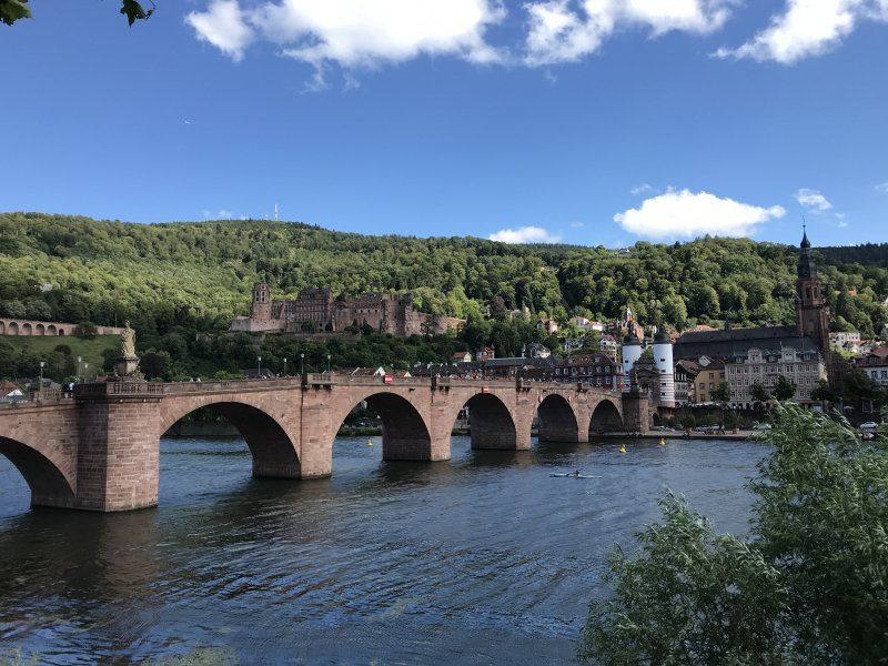
Very nice place from which we cycled to Heidelberg. We were lucky with the parking space because another motorhome cleared a very nice space when we arrived.
The Benz Museum is well worth seeing and worth a visit.
Heidelberger Straße 56, 68526, Ladenburg, Deutschland
49° 27' 57" N 8° 36' 53" E
49.4658333 8.6147222
• Head northeast on Heidelberger Straße. Go for 47 m.
• Turn left onto Heidelberger Straße. Go for 305 m.
• Turn right onto Trajanstraße. Go for 538 m.
• Turn left onto Schriesheimer Straße (K4238). Go for 539 m.
• Take the 2nd exit from roundabout onto Weinheimer Straße (K4238). Go for 746 m.
• Turn left onto L536. Go for 1.8 km.
• Continue on L597. Go for 3.8 km.
• Take ramp onto Siebenbürger Straße (K9751) toward MA-Zentrum. Go for 1.4 km.
• Continue on Banater Straße (L538) toward MA-Zentrum/SAP-Arena. Go for 1.6 km.
• Take ramp onto B38A toward MA-Käfertal-Zentrum. Go for 1.0 km.
• Keep left onto B38A toward MA-Zentrum/Krankenhaus. Go for 30 m.
• Turn left onto Feudenheimer Straße (L538) toward MA-Zentrum/Krankenhaus. Go for 2.8 km.
• Turn right onto Käfertaler Straße (L538) toward Neckarstadt. Go for 787 m.
• Keep left toward Alter Meßplatz. Go for 26 m.
• Continue on Alter Meßplatz. Go for 189 m.
• Continue on Kurpfalzbrücke. Go for 221 m.
• Turn right onto Kurpfalzkreisel. Go for 16 m.
• Keep right onto Luisenring. Go for 988 m.
• Take ramp onto Kurt-Schumacher-Brücke (B44) toward A650/A61/Ludwigshafen. Go for 1.8 km.
• Take ramp onto Pasadenaallee (K8) toward Stadion LU-Süd/Zentrum/Hbf. Go for 665 m.
• Turn right onto Lorientallee (K8). Go for 490 m.
• Turn right onto Rohrlachstraße (K5). Go for 186 m.
• Continue toward Rohrlachstraße/K5. Go for 34 m.
• Turn left onto Bürgermeister-Grünzweig-Straße. Go for 325 m.
• Continue on Industriestraße. Go for 1.8 km.
• Arrive at Industriestraße. Your destination is on the right.
☍
22,2 km
( 29 min.)
Day
Industriestraße 48, Ludwigshafen am Rhein, Deutschland
Handover of AUDI to dealers for assessment.
Onward journey towards Lahnstein. Leave the A61 at Bingen am Rhein and along the B9 along the Rhine to Lahnstein. We then interrupted the goal in St. Goar on the CP Loreley for one day and one night. Lahnstein then started the next day.
Industriestraße 48, 67063 Ludwigshafen am Rhein, Deutschland
49° 29' 21.2" N 8° 24' 8" E
49.4892283 8.4022182
• Head west on Industriestraße. Go for 809 m.
• Turn left onto Sternstraße (K3). Go for 1.9 km.
• Take ramp onto A650 toward Mainz/Bad Dürkheim/Speyer/Neustadt/Weinstr. Go for 4.5 km.
• Take exit 5 toward Koblenz/Mainz/Kaiserslautern onto A61. Go for 66.2 km.
• Take exit 49 toward Bingen-Mitte/St. Goar/Rhein. Go for 268 m.
• Continue on B9. Go for 607 m.
• Take left ramp onto B9 toward Bingen/Sportzentrum/St. Goar. Go for 1.3 km.
• Keep left onto B9 toward St. Goar/Bin.-Bingerbrück. Go for 28.5 km.
• Turn right onto An der Loreley. Go for 11 m.
• Arrive at An der Loreley. Your destination is on the right.
☍
104,1 km
(1 hrs. 9 min.)
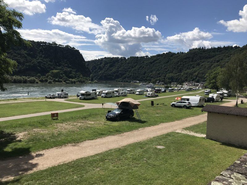
Camping Loreleyblick
A nice campsite for € 28 a night with bread service in the morning.
The course is within sight of the Lorelei on the Rhine. There are many trains on both banks that are relatively loud. The campsite is located between the train, road and Rhine.
Strolled a little in St. Goar and bought good peach liqueur and peach brandy.
An der Loreley 49-50, 56329, St. Goar, Deutschland
50° 8' 32.3" N 7° 43' 18.5" E
50.1423000 7.7218000
• Head west on An der Loreley. Go for 11 m.
• Turn right onto An der Loreley (B9). Go for 14.4 km.
• Keep left onto Koblenzer Straße (B9) toward A61/Koblenz. Go for 11.7 km.
• Take the 2nd exit from roundabout onto B9 toward Koblenz. Go for 7.6 km.
• Take ramp toward A61/Hermeskeil/B327/Montabaur/B49/Lahnstein/B42/KO-Karthause. Go for 369 m.
• Take left ramp onto Südbrücke (B327) toward Montabaur/B49/Lahnstein/B42. Go for 1.4 km.
• Take ramp onto B42 toward Rüdesheim/Lahnstein Industriegebiet/Bad Ems. Go for 478 m.
• Take ramp toward Niederlahnstein/Gewerbegebiet Nord/KO-Horchheim. Go for 267 m.
• Continue on Kölner Straße. Go for 284 m.
• Take the 2nd exit from roundabout onto Kölner Straße. Go for 692 m.
• Take the 2nd exit from roundabout onto Bahnhofstraße. Go for 578 m.
• Take the 1st exit from roundabout. Go for 30 m.
• Continue on Johann-Baptist-Ludwig-Straße. Go for 262 m.
• Turn left onto Im Nauling. Go for 267 m.
• Turn right onto Johannesstraße. Go for 177 m.
• Arrive at Johannesstraße. Your destination is on the right.
☍
38,4 km
( 36 min.)
Day
Stellplatz Kränchen
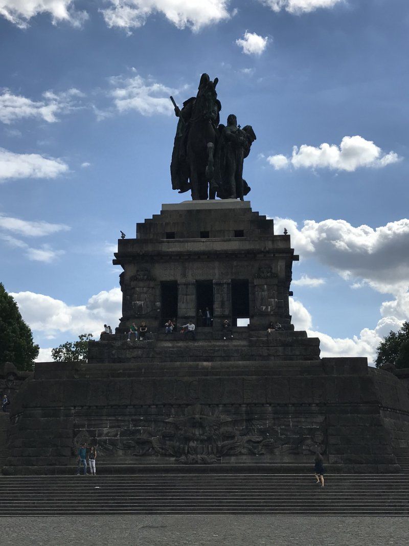
From here bike tour to Koblenz to the German Corner and Ehrenbreitstein Castle.
We got the last place near the supply station. 11 € / night was okay. In the morning there was a strong rush to dispose of what we weren't waiting for and drove on.
Johannesstraße, 56112, Lahnstein, Deutschland
50° 18' 34" N 7° 35' 54" E
50.3094444 7.5983333
• Head east on Johannesstraße. Go for 177 m.
• Turn slightly right onto Johannesstraße. Go for 240 m.
• Turn left onto Brückenstraße. Go for 105 m.
• Continue on Bahnhofstraße. Go for 225 m.
• Take the 2nd exit from roundabout onto Bahnhofstraße. Go for 567 m.
• Take the 2nd exit from roundabout onto Kölner Straße. Go for 689 m.
• Take the 1st exit from roundabout onto Hermsdorfer Straße. Go for 191 m.
• Turn left and take ramp onto B42 toward Koblenz. Go for 550 m.
• Take ramp onto B327 toward A61/Koblenz/B9. Go for 1.6 km.
• Take ramp toward Boppard/Koblenz/KO-Oberwerth/Krankenhaus Ev.-Stift/B9. Go for 805 m.
• Continue on Römerstraße (B9). Go for 1.9 km.
• Keep left onto Cusanusstraße (B9) toward Bonn/Cochem/B49/Europabrücke/Zentrum. Go for 520 m.
• Keep left onto Moselring (B9) toward Bonn/Mayen/Europabrücke/Uni/Krankenhaus der Bundeswehr/Cochem/B49/KO-Moselweiß/Krankenhaus Kemperhof/Krankenhaus Marienhof/KO-Rauental. Go for 886 m.
• Keep left onto Europabrücke (B9) toward Bonn/KO-Lützel Gewerbegebiet. Go for 4.2 km.
• Take ramp onto A48 toward Trier/Köln/Ludwigshafen. Go for 6.1 km.
• Take exit 9 toward Köln onto A61. Go for 81.3 km.
• Keep right onto A61 (Autobahndreieck Erfttal) toward Venlo/Mönchengladbach/Aachen. Go for 6.8 km.
• Take exit 21 toward Kerpen-Süd onto L496. Go for 964 m.
• Continue on B264. Go for 82 m.
• Keep left onto B264. Go for 841 m.
• Pass 2 roundabouts and continue on B264. Go for 7.1 km.
• Take the 2nd exit from roundabout onto B477 toward Bergheim/Elsdorf/Buir. Go for 730 m.
• Turn left onto L276 toward Buir. Go for 1.2 km.
• Take the 2nd exit from roundabout onto Zum Schlichshof (L276). Go for 742 m.
• Turn right onto Manheimer Straße. Go for 161 m.
• Turn left onto Eichemstraße. Go for 470 m.
• Turn right onto Bahnstraße (L276). Go for 370 m.
• Take the 1st exit from roundabout onto L276. Go for 840 m.
• Continue straight ahead. Go for 479 m.
• Arrive at your destination.
☍
120,9 km
(1 hrs. 18 min.)
Day
Hambacher Forst, Kerpen, Deutschland
From Lahnstein we drove across to NRW in the direction of the Hambacher open-cast mine. There we took photos of the opencast mine at various viewpoints. Gigantic area with approx.4,000 hectares.
50170 Kerpen, Deutschland
50° 52' 49.8" N 6° 33' 46.6" E
50.8805126 6.5629491
• Head toward Von-Morschenich. Go for 479 m.
• Continue on L276. Go for 181 m.
• Turn left onto An den Birkenhöfen (K4). Go for 2.9 km.
• Turn right onto K53 toward Zülpich/Bergheim/B477. Go for 2.3 km.
• Take the 3rd exit from roundabout onto B477 toward Bergheim/Elsdorf/A4. Go for 2.0 km.
• Take the 2nd exit from roundabout onto B477 toward A4/Bergheim/Elsdorf. Go for 1.8 km.
• Take the 2nd exit from roundabout onto A4 toward Köln. Go for 15.6 km.
• Take the exit toward Dortmund/Düsseldorf/Köln-Nord onto A1. Go for 9.7 km.
• Take exit 101 toward Köln-Zentrum/K-Zentrum onto A57. Go for 5.4 km.
• Continue on K4. Go for 1.1 km.
• Keep left onto K4 toward Flughafen/Zoobrücke. Go for 579 m.
• Continue on Innere Kanalstraße (L100). Go for 2.1 km.
• Take ramp onto Amsterdamer Straße toward Niehl. Go for 387 m.
• Continue on Elsa-Brändström-Straße toward Riehl/Niehl. Go for 230 m.
• Turn left onto Konrad-Adenauer-Ufer (B51) toward Riehl/Niehl. Go for 1.1 km.
• Take ramp onto B51 toward Mülheimer Brücke/Mülheim. Go for 216 m.
• Turn right onto An der Schanz. Go for 26 m.
• Turn slightly right onto An der Schanz. Go for 45 m.
• Turn slightly right. Go for 155 m.
• Arrive at your destination on the right.
☍
46,2 km
( 38 min.)
Reisemobilhafen Köln
The planned onward journey to Waldeck on the Edersee was interrupted by a passage barrier for vehicles with a gross vehicle weight of 3.5 t, whereupon we decided to spend the night in Cologne. We chose the SP An der Schanz am Rhein. 11 € with a view of the Rhine is okay. The next morning we went on to Waldeck.
An der Schanz, 50735, Köln, Deutschland
50° 57' 45" N 6° 59' 8" E
50.9625000 6.9855556
• Head toward An der Schanz. Go for 155 m.
• Turn slightly left onto An der Schanz. Go for 97 m.
• Turn right onto B51. Go for 1.7 km.
• Turn left onto Clevischer Ring (B51). Go for 1.5 km.
• Keep right onto Clevischer Ring toward A3. Go for 128 m.
• Continue on Mülheimer Zubringer. Go for 997 m.
• Take left ramp onto A3 toward Oberhausen. Go for 6.4 km.
• Take exit 23 toward Dortmund onto A1. Go for 77.6 km.
• Take the exit toward Unna/Kassel/Paderborn onto A44. Go for 99.3 km.
• Take exit 64 toward Korbach/Bad Arolsen/Diemelstadt onto B252. Go for 18.8 km.
• Turn left onto L3118. Go for 5.3 km.
• Continue on Waldecker Straße (L3118). Go for 7.5 km.
• Turn left onto B251 toward Kassel/Bad Wildungen/Sachsenhausen. Go for 183 m.
• Turn right onto B485. Go for 1.5 km.
• Turn right onto Nieder-Werber-Straße (L3200) toward Nieder-Werbe. Go for 4.8 km.
• Turn right onto L3086 toward Frankenberg/Vöhl/Basdorf/Scheid. Go for 58 m.
• Turn left onto K22. Go for 1.7 km.
• Continue on K22. Go for 83 m.
• Continue on K22. Go for 87 m.
• Continue on Am Bettenhagen (K22). Go for 729 m.
• Arrive at Am Bettenhagen (K22). Your destination is on the right.
☍
228,5 km
(2 hrs. 28 min.)
Day
Day
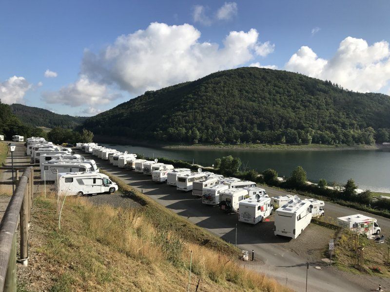
Am Bettenhagen 2, 34513 Waldeck
Onward journey to Waldeck at the Edersee on the parking space Edersee-Alm. Very nice terraced SP, from which every camper has a clear view of the Eder reservoir. Recommendable. With 15 € not exactly cheap but the view is worth it. We spent two nights here.
Am Bettenhagen 2
51° 11' 17.9" N 9° 0' 35.4" E
51.1882930 9.0098375
• Head north on Am Bettenhagen (K22). Go for 729 m.
• Continue on K22. Go for 1.9 km.
• Turn right onto L3086. Go for 58 m.
• Turn left onto Uferstraße (L3200). Go for 6.5 km.
• Turn right onto B251. Go for 18.5 km.
• Turn right onto B251/B450 toward A44/Kassel/Fritzlar. Go for 5.8 km.
• Take ramp onto A44 toward Kassel. Go for 18.3 km.
• Take the left exit toward Hamburg/Hannover/Kassel onto A7. Go for 210 km.
• Take exit 48 toward Bremen/Walsrode onto A27. Go for 11.4 km.
• Take exit 27 toward Walsrode/Rethem/Nienburg. Go for 326 m.
• Turn left onto Verdener Straße (B209) toward Visselhövede/Walsrode. Go for 2.1 km.
• Turn slightly left onto Neue Straße (B209) toward Rotenburg. Go for 186 m.
• Continue on Bergstraße (L161). Go for 1.3 km.
• Turn right onto Am Vogelpark (K129). Go for 1.5 km.
• Turn right onto Am Rieselbach. Go for 65 m.
• Arrive at Am Rieselbach. Your destination is on the right.
☍
278,9 km
(2 hrs. 44 min.)
Day
Vogelpark Walsrode, Am Vogelpark, Walsrode, Deutschland
Free SP with power supply and V / E.
Spent a quiet night here and went to the World Bird Park the next day. Very nice park with lots of exotic birds. Air show was suspended but replaced by so-called training flights. Very nice.
Am Vogelpark, 29664 Walsrode, Deutschland
52° 52' 56" N 9° 35' 55.9" E
52.8822148 9.5988702
• Head toward Am Vogelpark on Am Rieselbach. Go for 65 m.
• Turn right onto Am Vogelpark (K129). Go for 823 m.
• Turn right onto Am Böhmeufer (K134). Go for 1.2 km.
• Continue on K134. Go for 1.6 km.
• Continue on Am Böhmeufer (K134). Go for 516 m.
• Turn right onto Walsroder Straße (K135). Go for 808 m.
• Continue on Bomlitzer Straße (K135). Go for 925 m.
• Continue on Uetzinger Straße (K135). Go for 1.0 km.
• Turn left onto Honerdingen (B209). Go for 3.3 km.
• Turn right onto B209 toward A7/Ostenholz/Siebensteinhäuser. Go for 2.1 km.
• Turn left and take ramp onto A7 toward Hamburg. Go for 69.5 km.
• Keep left onto Horster Dreieck toward Lübeck/Berlin/Hamburg/Lüneburg/A1. Go for 2.5 km.
• Continue on A1. Go for 13.2 km.
• Take exit 36 toward Lübeck/Berlin/Hamburg-Südost onto A1. Go for 24.6 km.
• Take exit 28 toward Ahrensburg/Großhansdorf onto L224 (Sieker Landstraße). Go for 7.7 km.
• Turn right onto Gartenholz. Go for 444 m.
• Arrive at Gartenholz.
☍
130,3 km
(1 hrs. 21 min.)
Day
Gartenholz, Ahrensburg, Deutschland
Our last day, when we were still in the bird park and started our journey home around 5:00 p.m.
Gartenholz, 22926 Ahrensburg, Deutschland
53° 41' 18.6" N 10° 14' 41" E
53.6885070 10.2447134
Day