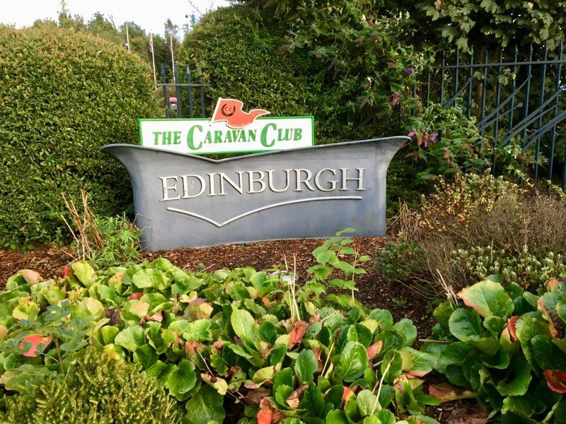
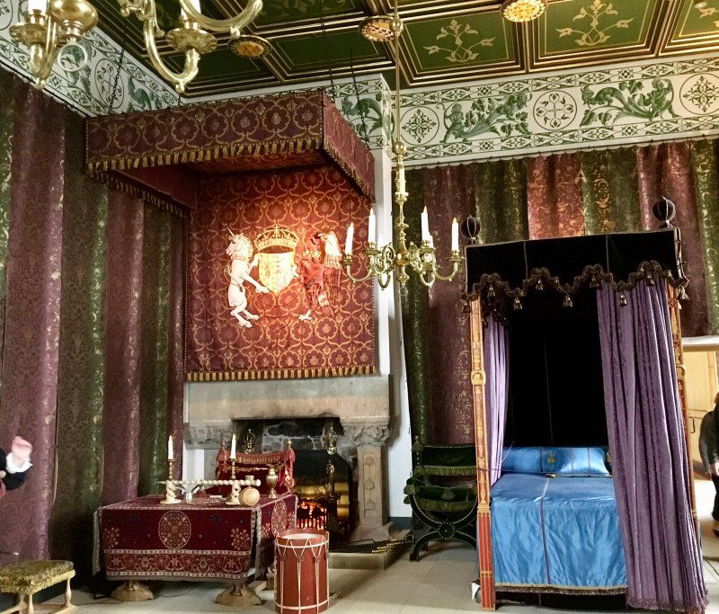
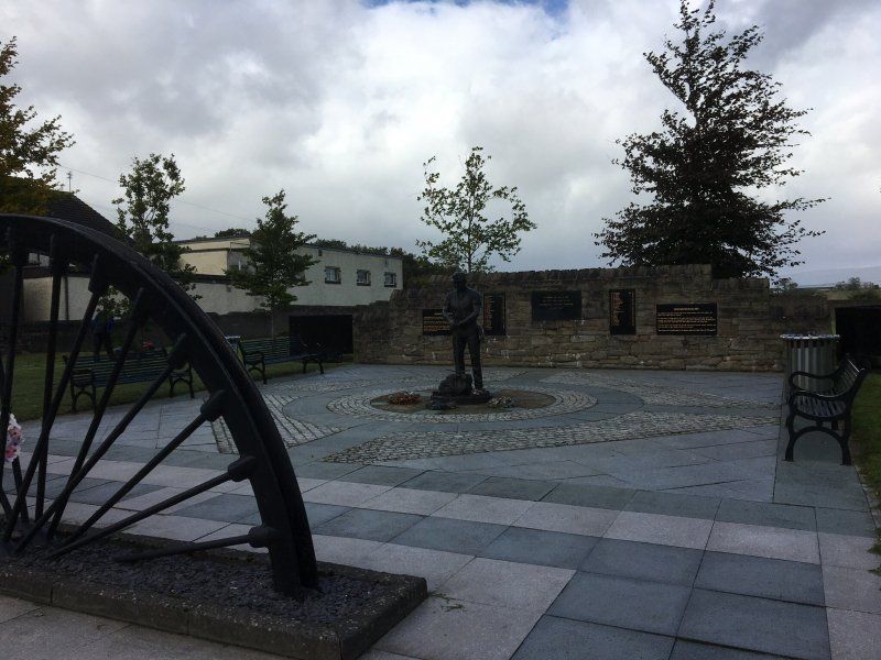
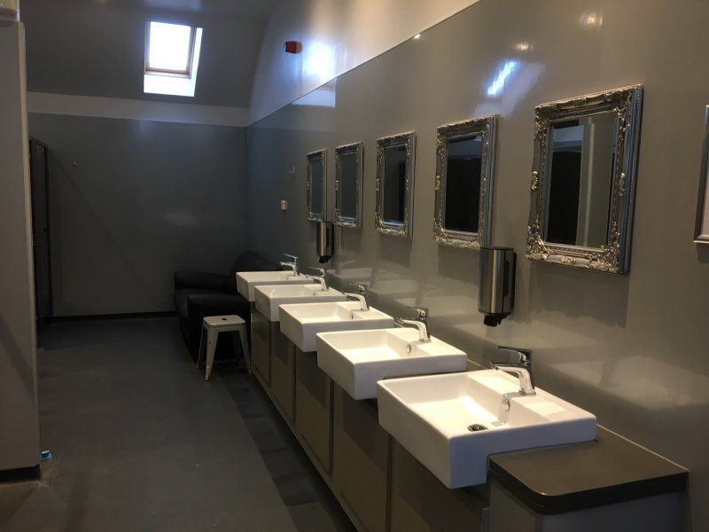
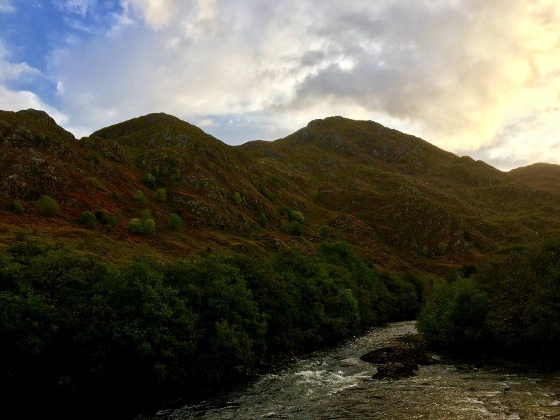
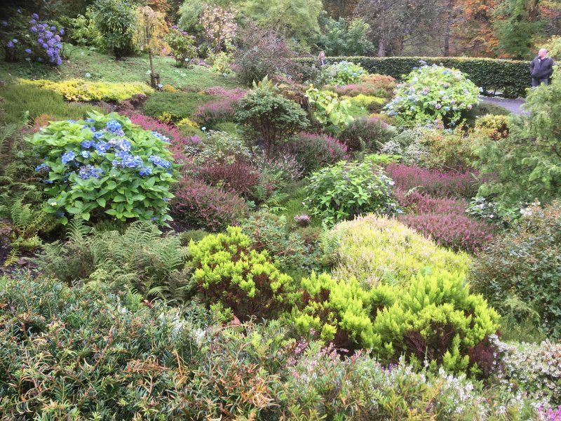
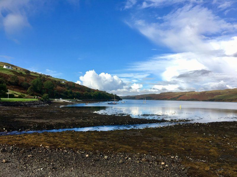
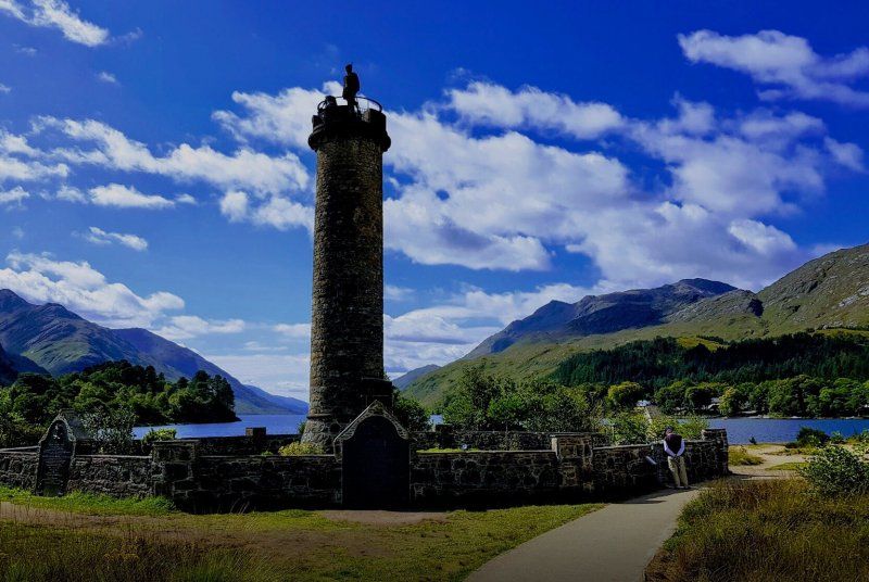
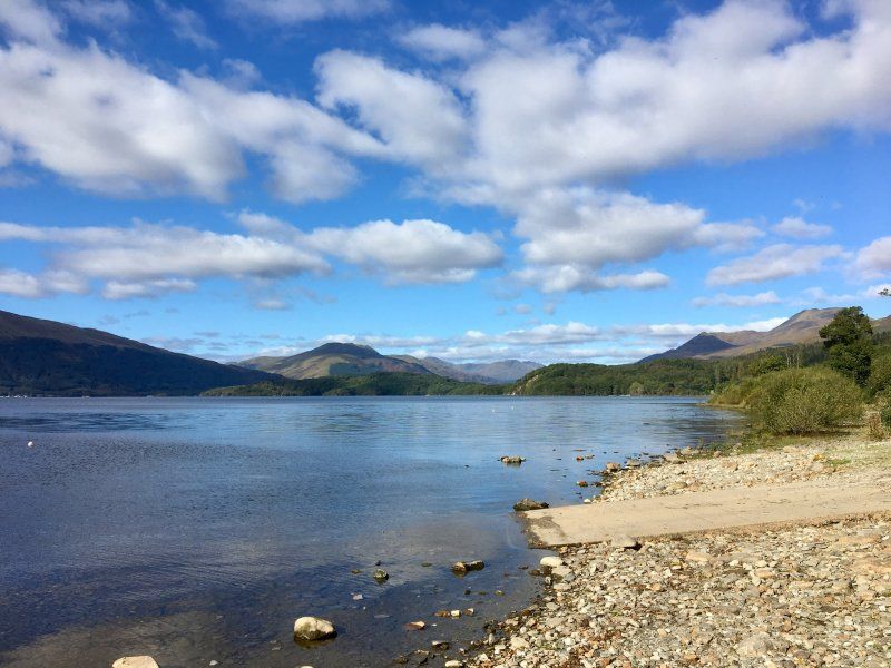
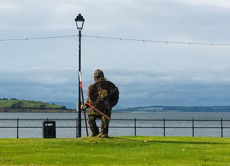
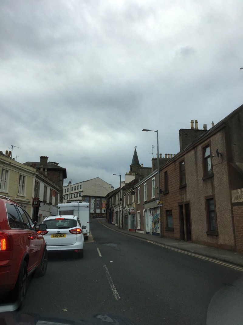
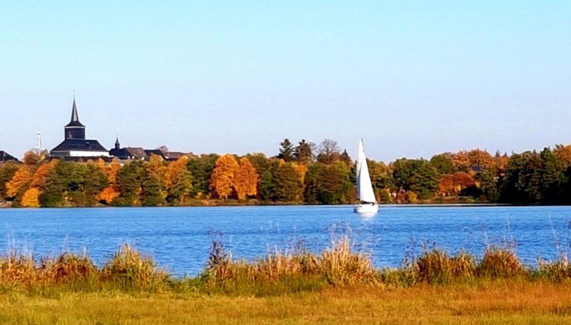
Weißenstadt, Deutschland
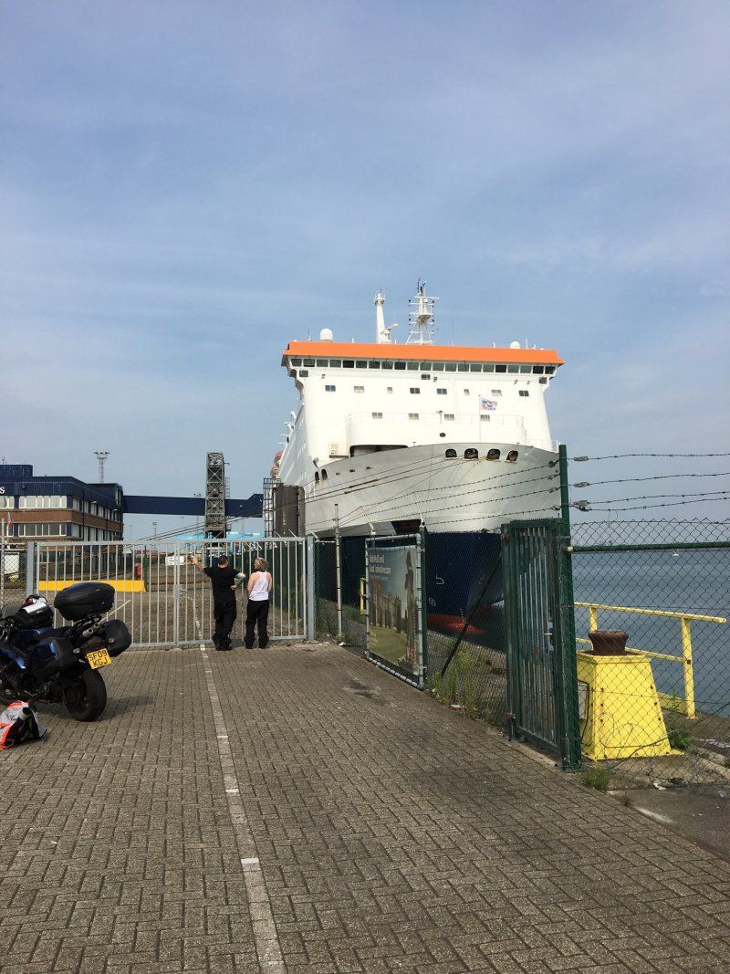
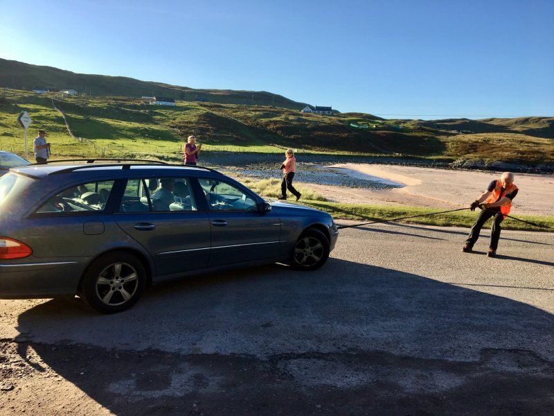
08/22/19 It starts today. It starts around noon. The planned destination is Duisburg, we want to visit friends here. Unfortunately nothing came of it after 200 km our towing vehicle went on strike. We only got as far as Offenbach where we stayed overnight to visit a workshop the next day.
95163 Weißenstadt, Deutschland
50° 6' 5.4" N 11° 53' 7.8" E
50.1015135 11.8855088
• Head toward Zeller Straße on Marktplatz (WUN1). Go for 59 m.
• Turn left onto Marktplatz (WUN1). Go for 20 m.
• Continue on Bayreuther Straße (WUN1). Go for 318 m.
• Pass 2 roundabouts and continue on St2180. Go for 14.6 km.
• Take ramp onto A9 toward München/Nürnberg. Go for 11.2 km.
• Take exit 40A toward Würzburg/Schweinfurt/Bamberg/Kulmbach onto A70. Go for 120 km.
• Take the exit toward Ulm/Würzburg/Stuttgart onto A7. Go for 20.0 km.
• Take exit 101 toward Würzburg/Estenfeld/Rimpar onto B19. Go for 6.4 km.
• Keep left onto B19 toward Frankfurt/Stuttgart/Ansbach/B13/Schwäbisch Hall/Stadtring-Süd/Uni-Hubland. Go for 6.6 km.
• Take ramp onto A3 toward Frankfurt/Stuttgart. Go for 95.5 km.
• Arrive at A3. Your destination is on the right.
☍
274,2 km
(2 hrs. 37 min.)
Day
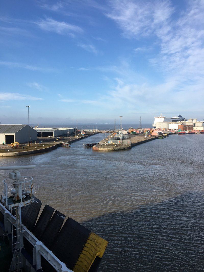
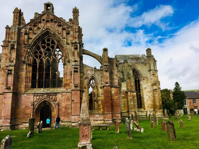
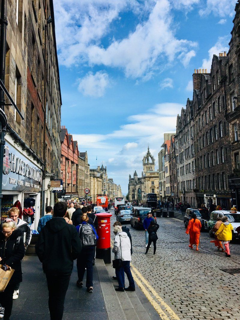
Offenbach
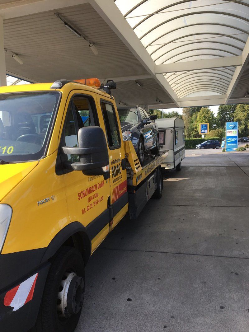
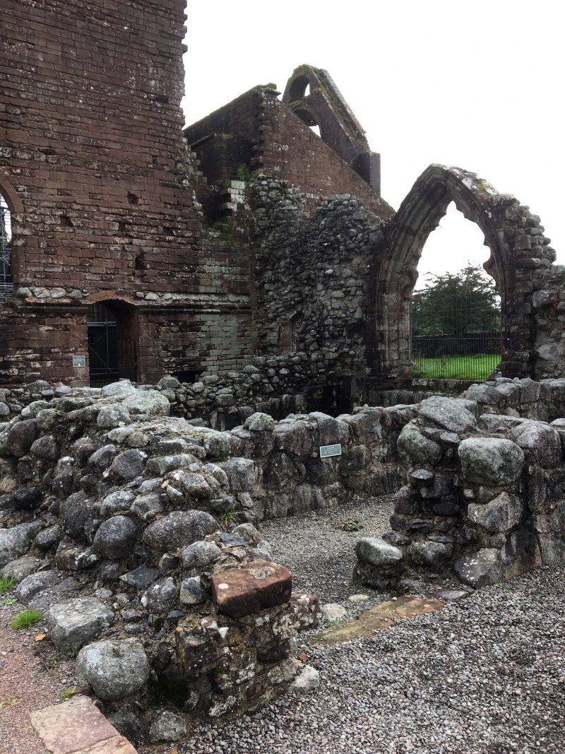
We spend the morning in the workshop and start again around noon. But we won't get far again. We are back at the Leverkusen junction. This time nothing works. We need a tow truck that will take us to Cologne. It goes to a workshop again. Since it is now Friday evening, the workshop only has an emergency service and we have to wait until Monday until it can be repaired. We spend the weekend at the camping site Stadt Köln in Cologne-Poll.
A3
50° 3' 36.1" N 8° 52' 34.8" E
50.0600269 8.8763202
• Head west on A3. Go for 190 km.
• Take exit 28 toward Köln-Süd/Aachen/Köln-Deutz onto A4. Go for 5.6 km.
• Take exit 13 toward K.-Poll/K.-Porz/Zentrum/Poll. Go for 423 m.
• Turn left onto Siegburger Straße (L82) toward Zentrum/Poll. Go for 875 m.
• Turn left onto Salmstraße. Go for 513 m.
• Turn right onto Poller Hauptstraße. Go for 184 m.
• Turn slightly right onto Weingartengasse. Go for 13 m.
• Turn slightly left onto Maifischgasse. Go for 72 m.
• Continue on Weidenweg. Go for 919 m.
• Arrive at Weidenweg. Your destination is on the right.
☍
198,8 km
(1 hrs. 49 min.)
Day
Camping der Stadt Köln
Campingplatz Stadt Köln, Weidenweg 35, 51105 Köln, Germany
50° 54' 10.1" N 6° 59' 26.2" E
50.9028000 6.9906000
• Head northwest on Weidenweg. Go for 919 m.
• Continue on Maifischgasse. Go for 72 m.
• Turn slightly right onto Weingartengasse. Go for 13 m.
• Turn slightly left onto Poller Hauptstraße. Go for 439 m.
• Turn left onto Auf dem Sandberg. Go for 352 m.
• Turn left onto Siegburger Straße (L82). Go for 3.1 km.
• Continue on Mindener Straße (L111). Go for 292 m.
• Turn sharp left onto Mindener Straße (L111). Go for 1.1 km.
• Turn right onto Heumarkt toward Altstadt. Go for 42 m.
• Turn left onto Gürzenichstraße. Go for 155 m.
• Turn slightly right onto Quatermarkt. Go for 109 m.
• Continue on Gülichplatz. Go for 42 m.
• Continue on Unter Goldschmied. Go for 257 m.
• Arrive at Unter Goldschmied.
☍
6,8 km
( 15 min.)
Day
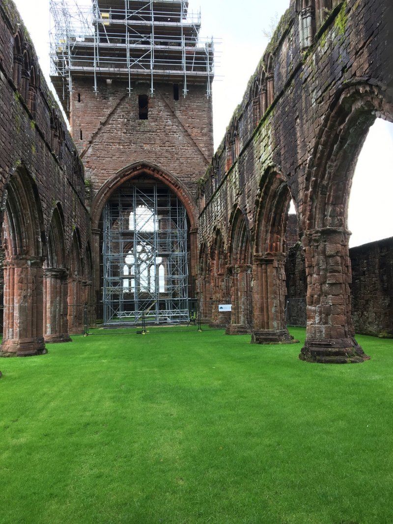
Köln
Domkloster 4, 50667 Köln, Germany
50° 56' 28.1" N 6° 57' 30.1" E
50.9411460 6.9583513
• Head north on Unter Goldschmied.
• Turn right onto Am Hof. Go for 114 m.
• Turn left onto Kurt-Hackenberg-Platz. Go for 62 m.
• Continue on Am Domhof. Go for 132 m.
• Turn right onto Am Bahndamm. Go for 137 m.
• Turn slightly left onto Am Bahndamm. Go for 102 m.
• Continue on Konrad-Adenauer-Ufer (B51). Go for 731 m.
• Keep right onto Heumarkt toward Deutzer Brücke/Koelnmesse/Altstadt. Go for 234 m.
• Continue on Pipinstraße (L111). Go for 676 m.
• Turn right onto Siegburger Straße (L82) toward Poll. Go for 3.3 km.
• Turn right onto Agnes-Freitag-Straße. Go for 233 m.
• Turn right onto Im Wasserfeld. Go for 159 m.
• Arrive at Im Wasserfeld. Your destination is on the left.
☍
5,9 km
( 11 min.)
Day
Poll
Im Wasserfeld 3, 51105 Köln, Germany
50° 54' 42.1" N 6° 59' 38.4" E
50.9116821 6.9940068
• Head toward Poller Hauptstraße on Im Wasserfeld. Go for 49 m.
• Turn right onto Auf dem Sandberg. Go for 352 m.
• Turn right onto Siegburger Straße (L82). Go for 707 m.
• Take ramp onto A4 toward Aachen/Bonn. Go for 66.6 km.
• Take the exit onto A4. Go for 6.1 km.
• Take exit 2 toward Ac.-Laurensberg/Ac.-Richterich/Ac.-Uniklinik/TH/Herzogenrath/Aachen/Laurensberg/RWTH/Uniklinik onto L232 (Kohlscheider Straße). Go for 1.5 km.
• Keep right onto Toledoring (L260) toward Außenring/Vaals/Uniklinik/RWTH-Hörn/RWTH-Melaten/Gewerbegebiet Süsterfeld. Go for 4.0 km.
• Turn right onto Vaalser Straße (B1) toward Maastricht/Vaals. Go for 527 m.
• Keep left onto Vaalser Straße (B1). Go for 1.0 km.
• Continue on Maastrichterlaan (N278). Go for 376 m.
• Take the 2nd exit from roundabout onto Maastrichterlaan (N278). Go for 1.1 km.
• Enter the roundabout. Go for 38 m.
• Arrive at your destination on the left.
☍
82,5 km
( 51 min.)
Day
Camping Hoeve de Gastmolen
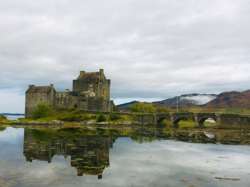
After the compulsory break in Cologne we change our plan and decide instead of going to Duisburg to Aachen to visit family. It goes to the Hoeve de Gastmolen in Vaals. It is already off season and we can use the Asci Card. As vacations in NRW and the Netherlands are already over, the place is not too crowded and we can choose our place for the night.
Lemierserberg 23, 6291 NM, Vaals, Niederlande
50° 46' 39" N 6° 0' 25.9" E
50.7775000 6.0072000
• Follow the roundabout. Go for 7 m.
• Take the 1st exit from roundabout onto Lemierserberg (N278) toward Nijswiller/Maastricht. Go for 3.2 km.
• Take the 1st exit from roundabout onto N278 toward Nijswiller/Maastricht. Go for 1.1 km.
• Keep right toward Baneheide/Bocholtz/Simpelveld/Heerlen. Go for 40 m.
• Take the 1st exit from roundabout onto Provincialeweg (N281) toward Baneheide/Bocholtz/Simpelveld/Heerlen. Go for 5.0 km.
• Turn left and take ramp onto A76 toward Maastricht/Eindhoven/Antwerpen/Industrieterrein Parkstad 1000-3000 8000-9900. Go for 25.0 km.
• Continue on E314 (Scharbergbrug). Go for 38.2 km.
• Take the exit toward Antwerpen onto E313 (Koning Boudewijnsnelweg). Go for 62.5 km.
• Continue on E34 (Antwerpen-Oost) toward Ring Antwerpen 1/Brugge/Gent/Haven 1000-2000/Brussel/Ring Antwerpen 2/Breda/Haven 1-999. Go for 1.8 km.
• Continue on E19 (Ring Antwerpen 1). Go for 2.4 km.
• Continue on E34 (Kleine Ring) toward Brugge/Gent/Haven 1000-2000. Go for 5.2 km.
• Take the exit onto E34 (Ring Antwerpen 1). Go for 81.2 km.
• Take ramp onto A11 toward E40/E403/Brugge/Haven Zeebrugge. Go for 5.7 km.
• Take the exit toward A11/Haven Zeebrugge onto Alfred Ronsestraat. Go for 5.0 km.
• Take the 4th exit from roundabout toward Oostende/Zeebrugge-Bad/Haven Car Ferries/Kaaien 100-499/Zeebrugge-Centrum/Kaaien 700-799. Go for 195 m.
• Turn slightly left onto Isabellalaan (N34). Go for 2.5 km.
• Keep right onto Minister Beernaertstraat toward E40/E403/Brugge/N31. Go for 344 m.
• Turn right and take ramp. Go for 219 m.
• Take the 1st exit from Posterijenplein roundabout onto Pieter Troostlaan toward Kaaien 100-199/Zeestation. Go for 285 m.
• Continue on Albert II Laan toward Kaaien 100-139. Go for 528 m.
• Take the 1st exit from Albert II Plein roundabout onto Engelandstraat. Go for 301 m.
• Take the 2nd exit from roundabout onto Vivesweg. Go for 189 m.
• Arrive at Vivesweg. Your destination is on the left.
☍
241,1 km
(2 hrs. 30 min.)
Day
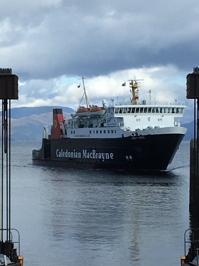
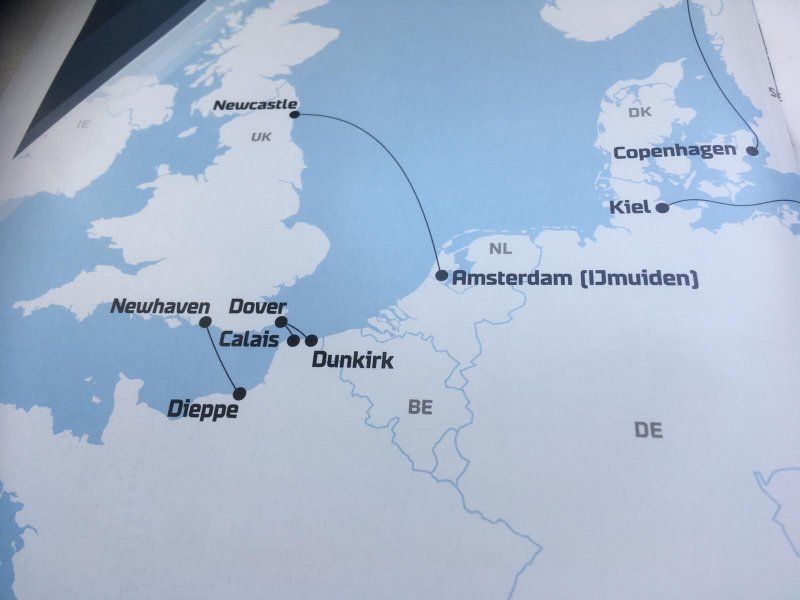
P&O Ferries Terminal Zeebrügge
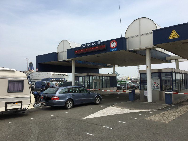
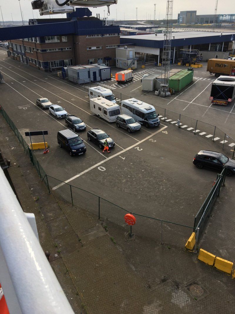
The next morning we continue to the ferry to Zeebrugge. We reach the ferry terminal shortly after noon. Check-in to Hull starts at 3pm. Everything is going smoothly and we leave punctually at 7:00 p.m.
Goltziusweg 45030, 8380 Brugge, Belgium
51° 20' 16.8" N 3° 11' 5.2" E
51.3380077 3.1847772
• Head northeast on Vivesweg. Go for 158 m.
• Continue on Leopold II-Dam. Go for 506 m.
• Make a U-Turn onto Leopold II-Dam. Go for 506 m.
• Continue on Vivesweg. Go for 251 m.
• Take the 2nd exit from roundabout onto Engelandstraat. Go for 337 m.
• Take the 2nd exit from Albert II Plein roundabout onto Albert II Laan. Go for 662 m.
• Continue on Pieter Troostlaan. Go for 250 m.
• Take the 2nd exit from Posterijenplein roundabout onto Baron de Maerelaan (E403) toward E40/Brugge/Knokke-Heist/N34/Zeebrugge-Centrum. Go for 4.5 km.
• Continue on Zeelaan (E403). Go for 2.5 km.
• Take ramp onto A11 toward E40/Brugge. Go for 928 m.
• Continue on Zeelaan (E403). Go for 9.4 km.
• Take ramp toward Zedelgem/St.-Michiels. Go for 316 m.
• Take the 1st exit from roundabout onto Koning Albert I-Laan (N397) toward Zedelgem. Go for 1.6 km.
• Take the 1st exit from roundabout onto E40 toward Oostende. Go for 50.5 km.
• Continue on A16 (Autoroute des Estuaires). Go for 56.7 km.
• Take exit 42 toward Tunnel S/S la Manche/Tunnel sous la Manche onto E15. Go for 978 m.
• Keep right onto E15. Go for 111 m.
• Take the 3rd exit from roundabout. Go for 724 m.
• Take the 2nd exit from roundabout. Go for 809 m.
• Turn right. Go for 89 m.
• Turn left. Go for 146 m.
• Turn right. Go for 103 m.
• Keep right. Go for 20 m.
• Take the Channel Tunnel car shuttle train. Stay on for 57.6 km.
• Head northeast. Go for 2.7 km.
• Take right ramp onto M20 toward London/Ashford. Go for 76.5 km.
• Take exit 1 toward Dartford Crossing/M25(N)/C. London/(A2) onto M25. Go for 6.7 km.
• Continue on A282. Go for 7.4 km.
• Continue on M25 toward M11/M1/Stansted Airport. Go for 25.4 km.
• Take exit 27 toward M11(S)/London (NE & C)/Stansted Airport/Harlow/Cambridge onto M11. Go for 46.1 km.
• Keep right onto M11 toward Cambridge. Go for 26.0 km.
• Keep right onto Huntingdon Road (A14) toward The North/The Midlands/Huntingdon. Go for 19.7 km.
• Take ramp onto A1 toward The North/Peterborough. Go for 6.3 km.
• Keep right onto A1(M) toward The North/Peterborough. Go for 20.7 km.
• Continue on Great North Road (A1). Go for 75.7 km.
• Take ramp toward Lincoln/Sleaford/(A17). Go for 273 m.
• Take the 1st exit from roundabout onto A46 toward Lincoln/Sleaford/(A17). Go for 323 m.
• Turn left onto A46 toward Lincoln/Gainsborough/(A1133)/Winthorpe/Collingham. Go for 1.2 km.
• Pass 6 roundabouts and continue on A46. Go for 22.1 km.
• Take the 2nd exit from Carholme Roundabout roundabout onto A46 toward Lincoln N'th/Grimsby/Immingham/(A15)/Skegness/(A158)/Riseholme/Ermine. Go for 2.8 km.
• Take the 1st exit from Riseholme Roundabout roundabout onto A15 toward Humber Bridge/Scunthorpe/Immingham/(M180). Go for 4.1 km.
• Pass 2 roundabouts and continue on A15. Go for 28.7 km.
• Take the 3rd exit from roundabout onto M180 toward Humber Br./Grimsby. Go for 10.4 km.
• Take exit 5 toward Humber Br./Hull/Airport. Go for 505 m.
• Take the 2nd exit from roundabout onto A15 toward Humber Bridge/Hull. Go for 15.5 km.
• Keep right onto Humber Bridge (A15). Go for 881 m.
• Take the 1st exit from roundabout onto Boothferry Road (A15) toward Leeds/(M62)/Hull/(A63). Go for 477 m.
• Take the 3rd exit from roundabout onto A15 toward Hull/(A63)/Bridlington/(A165)/Leeds/(M62)/Goole/(A614)/North Ferriby. Go for 195 m.
• Take ramp onto Clive Sullivan Way (A63) toward Hull/Bridlington/(A165). Go for 9.8 km.
• Turn left onto Market Place toward Old Town & Market/City Centre North. Go for 263 m.
• Continue on Lowgate. Go for 292 m.
• Continue on Wilberforce Drive. Go for 174 m.
• Turn left onto George Street. Go for 366 m.
• Turn left onto Bond Street. Go for 37 m.
• Continue on Vernon Street. Go for 18 m.
• Turn left onto Vernon Street. Go for 25 m.
• Turn left onto Dock Street. Go for 150 m.
• Arrive at Dock Street. Your destination is on the left.
☍
601,6 km
(7 hrs. 19 min.)
Day
Hull, Vereinigtes Königreich
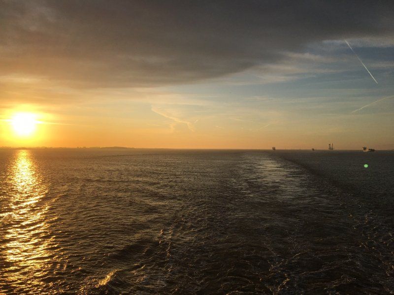
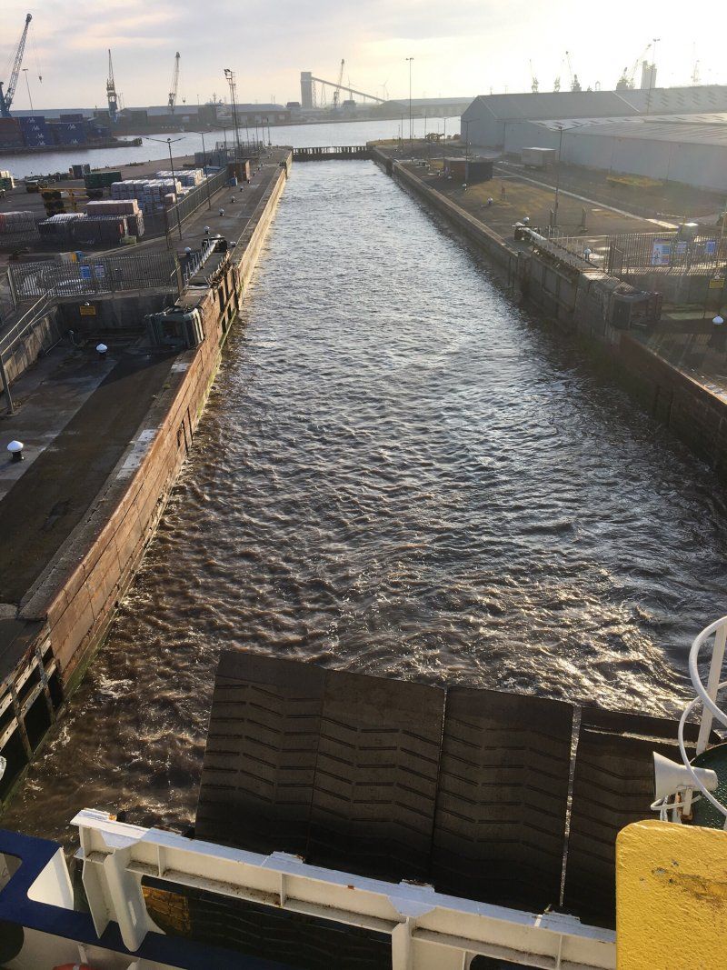
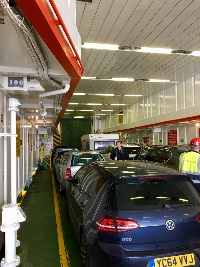
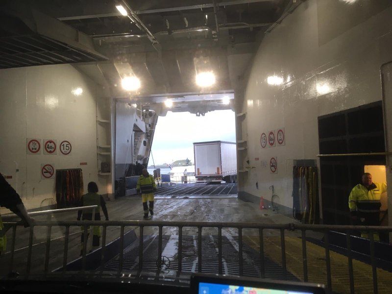
After a rather restless night (engine noise, bed rattling and last but not least grunts from the neighboring cabins) we reach Hull in the morning. To get to the landing place the ferry has to pass through a narrow port lock (millimeter work for captain and crew). After checking out and the border control we leave the port. From now on left-hand traffic, with a rather queasy feeling we drive off. Our destination for today is the Clark Hill Farm near Haltwhistle. Here we have booked for 4 nights.
Kingston Upon Hull, Hull, Vereinigtes Königreich
53° 44' 44.4" N 0° 20' 12.3" W
53.7456709 -0.3367413
• Head toward Grimston Drive on Dock Street. Go for 74 m.
• Turn left onto Grimston Street. Go for 57 m.
• Turn right onto George Street. Go for 176 m.
• Turn left onto Freetown Way (A165). Go for 900 m.
• Turn left onto Ferensway (A1079). Go for 618 m.
• Turn right onto Anlaby Road (A1105). Go for 950 m.
• Turn left onto Rawling Way. Go for 725 m.
• Take the 2nd exit from roundabout onto Daltry Street toward (M62)/Leeds/(A63)/Humber Br./(A15)/Goole/(A614)/WM Wright & Albert Docks. Go for 266 m.
• Take ramp onto Clive Sullivan Way (A63) toward Leeds/M62/Humber Bridge/A15/Goole/A614. Go for 23.3 km.
• Keep right onto M62 toward Leeds/Goole. Go for 45.0 km.
• Take exit 32A toward The NORTH/Wetherby onto A1(M). Go for 13.2 km.
• Take the exit onto A1(M) (Aberford By Pass). Go for 134 km.
• Continue on A1. Go for 8.2 km.
• Keep right onto A1 toward Newcastle/Airport/Hexham/(A69). Go for 5.9 km.
• Take ramp toward Hexham/City (West). Go for 243 m.
• Keep left toward Hexham. Go for 144 m.
• Continue on A69. Go for 18.6 km.
• Take the 3rd exit from Styford roundabout onto A69 toward Hexham/Carlisle. Go for 33.4 km.
• Turn right onto B6322 toward Haltwhistle. Go for 814 m.
• Turn right onto Lantys Lonnen. Go for 194 m.
• Turn right onto Main Street. Go for 72 m.
• Turn slightly left toward Fair Hill. Go for 172 m.
• Turn left onto Fair Hill. Go for 147 m.
• Arrive at Fair Hill. Your destination is on the right.
☍
286,9 km
(2 hrs. 49 min.)
Haltwhistle, Vereinigtes Königreich
Haltwhistle NE49, Vereinigtes Königreich
54° 58' 20.1" N 2° 27' 39.1" W
54.9722370 -2.4608560
• Head toward Comb Hill Road on Fair Hill. Go for 10 m.
• Turn left onto Aesica Road. Go for 222 m.
• Turn right onto Westgate. Go for 242 m.
• Continue on Station Road. Go for 47 m.
• Turn right onto West Road (B6322). Go for 244 m.
• Continue on Tyne View Road (B6322). Go for 735 m.
• Continue on B6322. Go for 120 m.
• Turn right onto A69 toward Carlisle/Brampton/Greenhead. Go for 19.4 km.
• Take the 2nd exit from roundabout onto A689 toward Carlisle Airport/Crosby. Go for 4.7 km.
• Take the 1st exit from roundabout onto A689 toward Carlisle. Go for 5.4 km.
• Take the 3rd exit from roundabout onto A689. Go for 3.6 km.
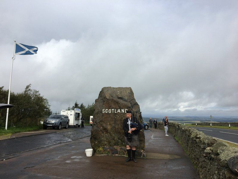
• Take the 4th exit from Greymoorhill roundabout toward SCOTLAND/Glasgow/Edinburgh/Dumfries. Go for 285 m.
• Take ramp onto M6. Go for 9.5 km.
• Continue on A74(M). Go for 946 m.
• Take exit 22 toward Gretna. Go for 886 m.
• Turn left onto Glasgow Road (B7076) toward Glasgow/Edinburgh/(A74(M))/Gretna Green/Springfield. Go for 337 m.
• Turn right onto Gretna Loaning (B7076) toward (Springfield). Go for 378 m.
• Turn right. Go for 10 m.
• Arrive at your destination.
☍
47,1 km
( 34 min.)
Day
Gretna Green, Gretna, Vereinigtes Königreich
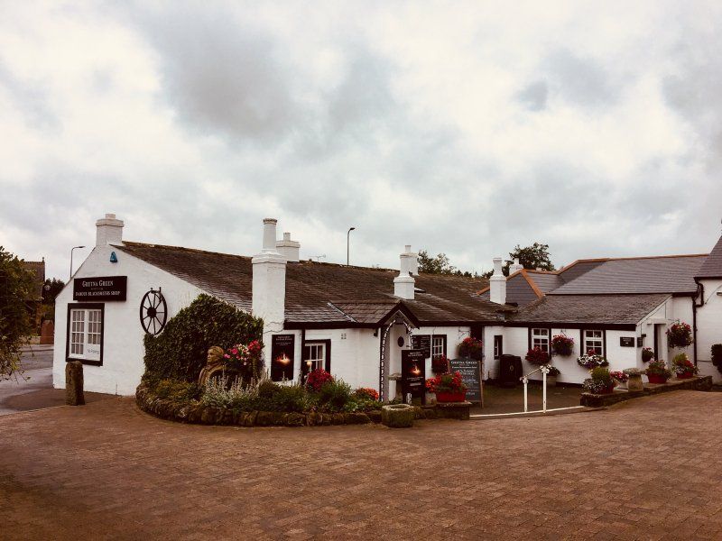
We looked at the blacksmiths and the museum in Gretna Green. Fortunately, we were there early, around noon, it was then really full.
Gretna Green, Gretna DG16, Vereinigtes Königreich
55° 0' 18.1" N 3° 3' 45.4" W
55.0050199 -3.0626071
• Head west. Go for 10 m.
• Turn left onto Gretna Loaning (B7076) toward Glasgow/(A74(M))/Edinburgh/Carlisle/(M6)/Dumfries/(A75)/Gretna. Go for 378 m.
• Turn left onto Glasgow Road (B7076) toward Carlisle/(M6)/Dumfries/(A75)/Stranraer/Gretna. Go for 895 m.
• Take the 2nd exit from Crossways Roundabout roundabout onto Glasgow Road (B7076). Go for 870 m.
• Continue on A6071. Go for 123 m.
• Turn right and take ramp onto M6 toward Carlisle. Go for 9.3 km.
• Take exit 44 toward Carlisle/Workington. Go for 388 m.
• Take the 4th exit from Greymoorhill roundabout onto Kingstown Road (A7) toward Carlisle. Go for 3.9 km.
• Take the 4th exit from Hardwicke Circus roundabout onto Castle Way (A595). Go for 1.2 km.
• Take the 4th exit from roundabout onto Church Street (A595). Go for 454 m.
• Turn left onto Devonshire Walk. Go for 122 m.
• Arrive at Devonshire Walk. Your destination is on the right.
☍
17,6 km
( 16 min.)
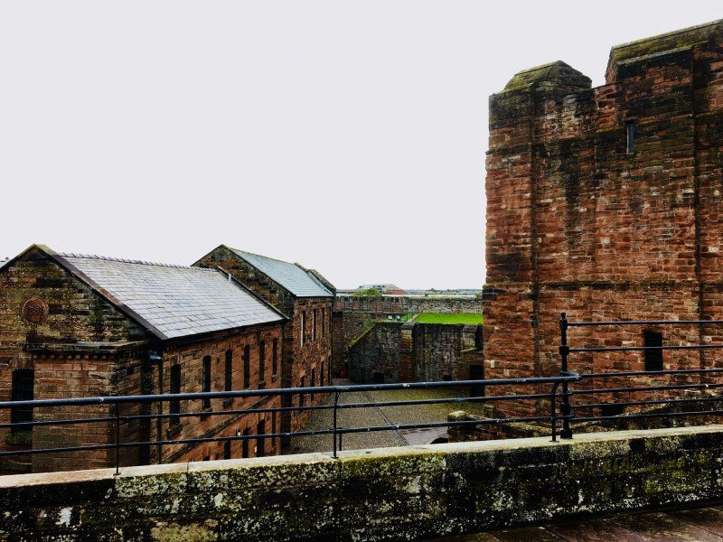
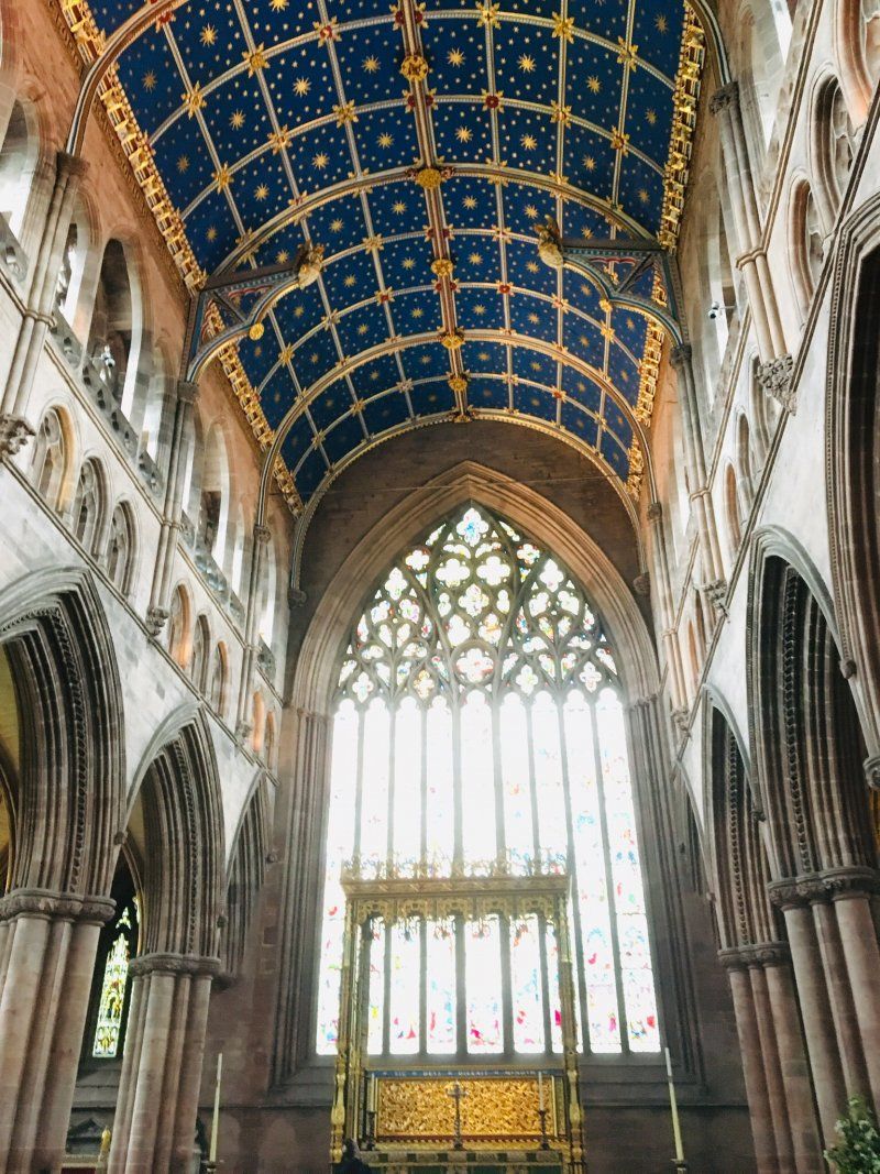
Carlisle Castle
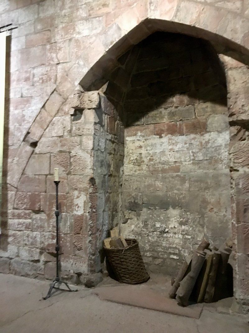
Then we went to Carlisle Castle, an 11th century castle, and Carlisle Cathedral.
Devonshire Walk, Carlisle CA3 8UR, UK
54° 53' 49.3" N 2° 56' 30.7" W
54.8970297 -2.9418720
• Head toward Bridge Street on Devonshire Walk. Go for 122 m.
• Turn left onto Castle Way (A595). Go for 563 m.
• Take the 1st exit from Hardwicke Circus roundabout onto Bridgewater Road (A7). Go for 401 m.
• Turn right onto Brampton Road (B6264). Go for 3.6 km.
• Take the 2nd exit from roundabout onto A689. Go for 5.4 km.
• Take the 2nd exit from roundabout onto A689 toward Hexham/Carlisle Airport. Go for 4.7 km.
• Take the 2nd exit from roundabout onto A69 toward Hexham/Newcastle/(A689). Go for 15.3 km.
• Turn left onto B6318 toward Greenhead/B630/Gilsland/Chollerford. Go for 275 m.
• Turn left onto Greenhead Bank (B6318). Go for 20 m.
• Turn right onto B6318. Go for 1.4 km.
• Continue on New Hall Farm (B6318). Go for 36 m.
• Continue on B6318. Go for 544 m.
• Continue on Fellview (B6318). Go for 39 m.
• Continue on B6318. Go for 857 m.
• Continue on Railway Terrace (B6318). Go for 59 m.
• Continue on B6318. Go for 140 m.
• Continue on Thirlwall Terrace (B6318). Go for 66 m.
• Continue on B6318. Go for 47 m.
• Turn right onto B6318. Go for 312 m.
• Turn left onto B6318. Go for 1.7 km.
• Turn left. Go for 729 m.
• Arrive at your destination on the left.
☍
36,4 km
( 30 min.)
Day
Hadrian's Wall, Brampton, Vereinigtes Königreich
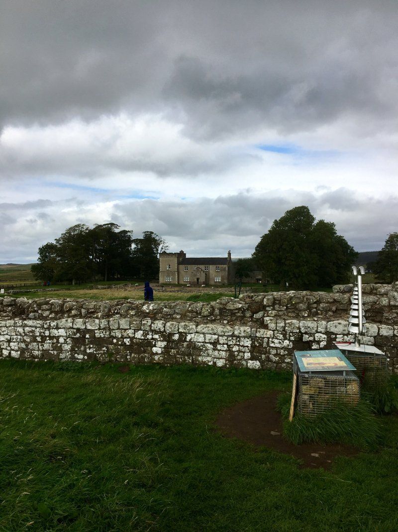
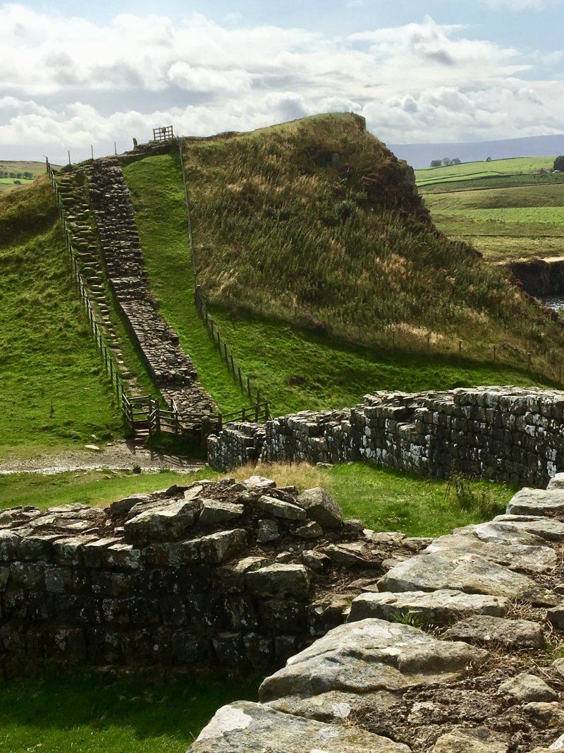
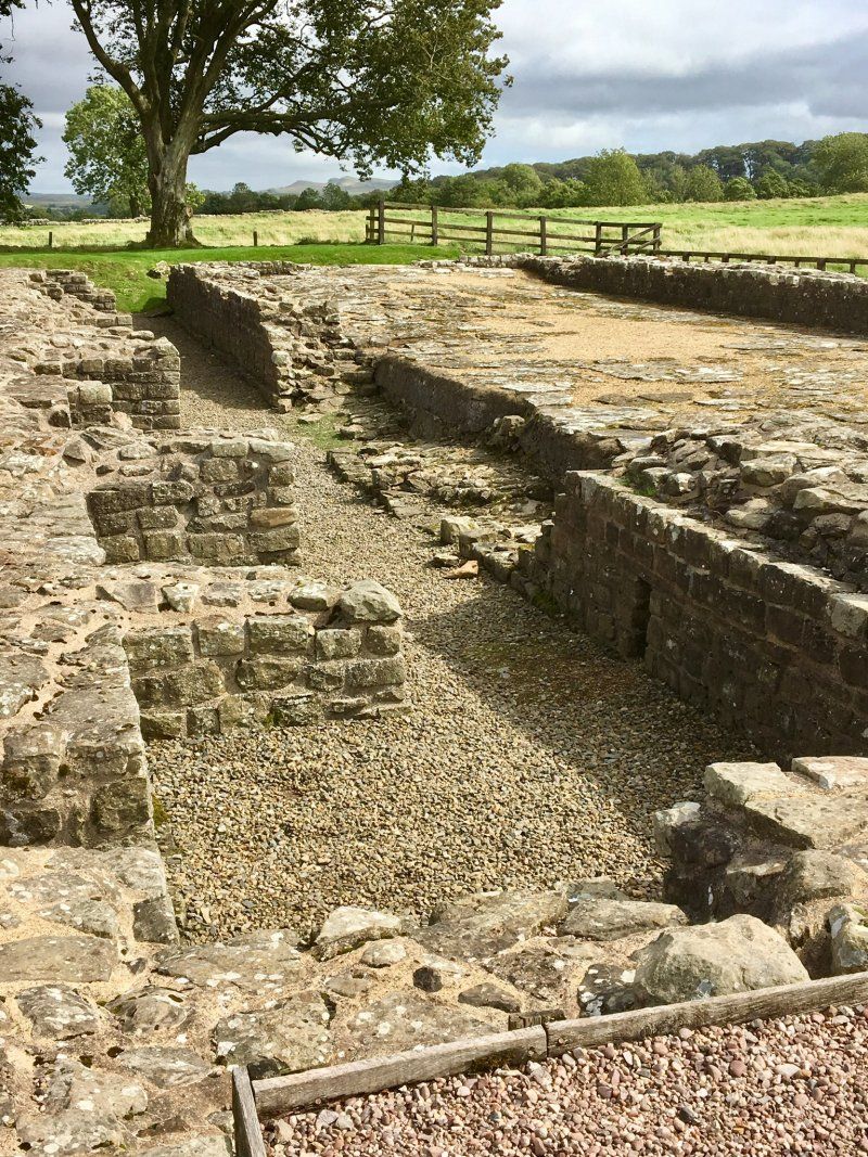
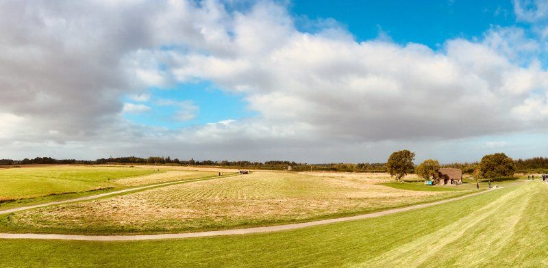
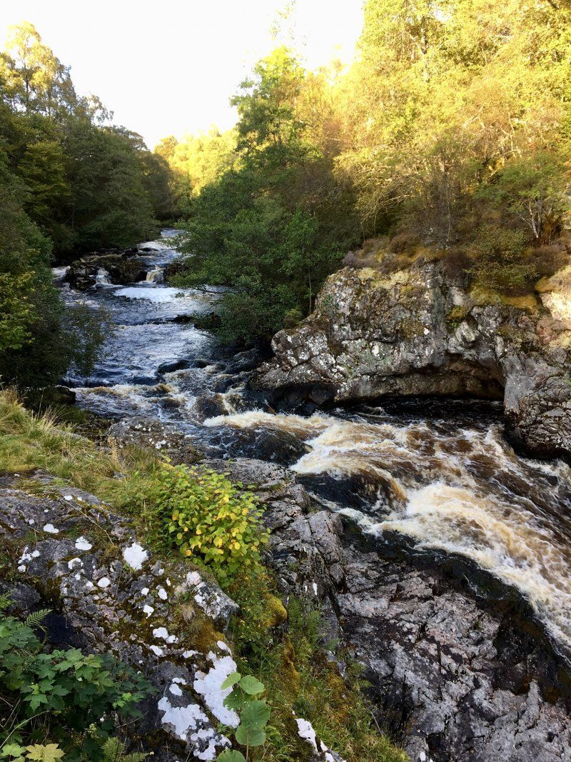
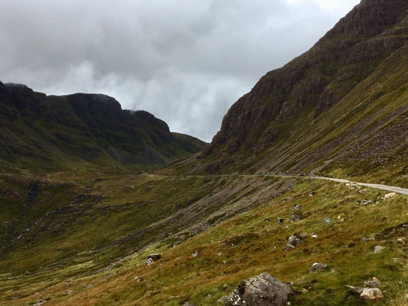
The next morning it was very windy and wet. The rain came horizontally. So that was not to think about a bigger trip. By noon rain and wind were less and we decided to drive to the nearby Roman fort Birdoswald on Hadrianswall. We visited the fort and as the weather got better we drove along the wall.
Brampton CA8 7DD, Vereinigtes Königreich
54° 59' 23.6" N 2° 36' 6.1" W
54.9898985 -2.6016963
• Head east. Go for 729 m.
• Turn right onto B6318. Go for 1.7 km.
• Turn right onto B6318. Go for 312 m.
• Turn left onto B6318. Go for 47 m.
• Continue on Thirlwall Terrace (B6318). Go for 66 m.
• Continue on B6318. Go for 140 m.
• Continue on Railway Terrace (B6318). Go for 59 m.
• Continue on B6318. Go for 857 m.
• Continue on Fellview (B6318). Go for 39 m.
• Continue on B6318. Go for 544 m.
• Continue on New Hall Farm (B6318). Go for 36 m.
• Continue on B6318. Go for 1.4 km.
• Turn left onto Greenhead Bank (B6318). Go for 20 m.
• Continue on Glenwhelt Bank (B6318). Go for 1.0 km.
• Continue on B6318. Go for 2.1 km.
• Continue on North Road (B6318). Go for 1.8 km.
• Continue on B6318. Go for 22.2 km.
• Continue on New Houses (B6318). Go for 182 m.
• Continue on B6318. Go for 146 m.
• Take the 1st exit from roundabout onto B6320. Go for 9.3 km.
• Continue on Hexham Road (B6320). Go for 577 m.
• Turn left onto Main Street (B6320). Go for 43 m.
• Turn right onto Church Lane (B6320). Go for 874 m.
• Continue on B6320. Go for 7.3 km.
• Turn left. Go for 5.0 km.
• Turn left toward Eals House. Go for 3.1 km.
• Continue on Eals House. Go for 5.1 km.
• Continue on Shilling Pot. Go for 6.8 km.
• Turn right toward The Border Forest Park. Go for 117 m.
• Continue on The Border Forest Park. Go for 2.8 km.
• Arrive at your destination.
☍
74,6 km
(1 hrs. 1 min.)
Day
Kielder Water, Hexham, Vereinigtes Königreich
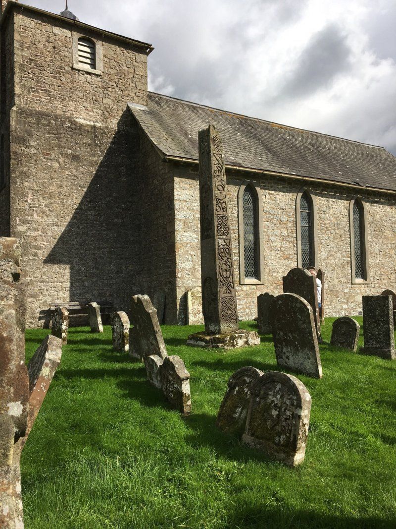
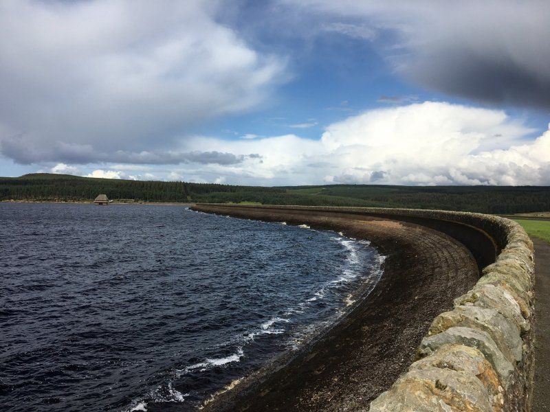
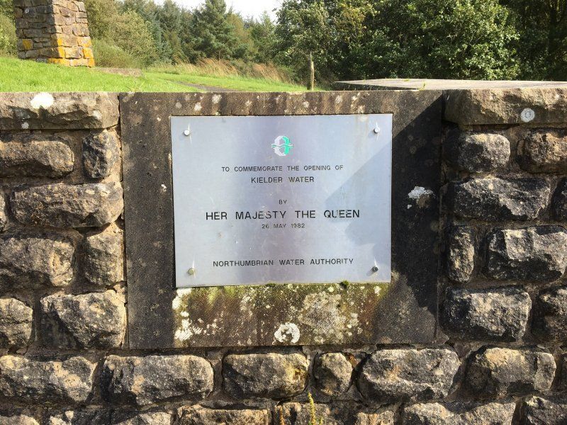
Today we are going on a day trip to Kielder Water. First it goes to Bewcastle Church, to get there you drive for a while through sheep pastures. The stele in front of the church dates from the 8th century. Then it goes on via Newcastleton to Kielder Water. From the Elf Kirk View you have a great view over the reservoir.
Kielder Water, Hexham NE48, Vereinigtes Königreich
55° 10' 52.8" N 2° 29' 5.3" W
55.1813287 -2.4848011
• Head west. Go for 1.3 km.
• Continue on The Border Forest Park. Go for 1.5 km.
• Turn right toward Catcleugh. Go for 8.8 km.
• Continue on Catcleugh. Go for 4.0 km.
• Continue on Deadwater. Go for 5.5 km.
• Continue on Saughtree. Go for 666 m.
• Turn right onto B6357. Go for 6.0 km.
• Continue on Singdean (B6357). Go for 183 m.
• Continue on B6357. Go for 4.7 km.
• Continue on Hyndlee (B6357). Go for 208 m.
• Continue on B6357. Go for 3.9 km.
• Continue on Cleuch Head (B6357). Go for 101 m.
• Continue on B6357. Go for 459 m.
• Turn left onto A6088. Go for 1.8 km.
• Turn right onto Greenriver Cottages (B6357). Go for 206 m.
• Continue on Sclentie Cottages (B6357). Go for 201 m.
• Continue on B6357. Go for 9.2 km.
• Turn left onto A68. Go for 2.7 km.
• Turn left onto Canongate (B6358) toward Town centre. Go for 131 m.
• Continue on Market Place (B6358). Go for 64 m.
• Arrive at Market Place (B6358). Your destination is on the right.
☍
51,7 km
( 47 min.)
Day
Jedburgh, Vereinigtes Königreich
It goes on. We hang up the caravan and drive via Jedburgh and Melrose on the east coast to Coldingham
Jedburgh TD8, Vereinigtes Königreich
55° 28' 39.8" N 2° 33' 17.8" W
55.4777210 -2.5549369
• Head toward Deans Close on Market Place (B6358). Go for 64 m.
• Continue on Canongate (B6358). Go for 131 m.
• Turn left onto A68. Go for 17.5 km.
• Take the 1st exit from roundabout onto A6091 toward Galashiels/Carlisle/(A7)/Borders General Hospital. Go for 2.7 km.
• Turn right onto High Road (B6374) toward Melrose. Go for 414 m.
• Continue on East Port (B6374). Go for 133 m.
• Continue on Market Square (B6374). Go for 7 m.
• Turn slightly left onto Market Square (B6374). Go for 82 m.
• Continue on High Street (B6374). Go for 121 m.
• Keep left onto High Street (B6374). Go for 328 m.
• Continue on High Cross Avenue (B6374). Go for 28 m.
• Arrive at High Cross Avenue (B6374). Your destination is on the right.
☍
21,5 km
( 18 min.)
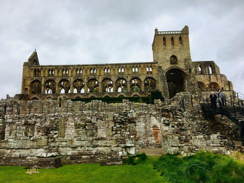
Melrose Abbey
2 High Cross Ave, Melrose TD6 9SE, UK
55° 35' 59" N 2° 43' 36.6" W
55.5997168 -2.7268310
• Head toward Huntly Road on High Cross Avenue (B6374). Go for 28 m.
• Continue on High Street (B6374). Go for 295 m.
• Turn left onto Buccleuch Street (B6361). Go for 199 m.
• Continue on Abbey Street (B6361). Go for 112 m.
• Continue on Market Square (B6361). Go for 43 m.
• Turn left onto Market Square (B6374). Go for 7 m.
• Continue on East Port (B6374). Go for 133 m.
• Continue on High Road (B6374). Go for 386 m.
• Turn left onto A6091. Go for 2.6 km.
• Take the 1st exit from roundabout onto A68 toward Earlston/Edinburgh. Go for 4.8 km.
• Turn right onto High Street (A6105) toward Town centre/Duns/Gordon/Greenlaw/Kelso. Go for 17.2 km.
• Turn right onto West High Street (A697). Go for 245 m.
• Turn left onto Duns Road (A6105) toward Duns/Chirnside. Go for 11.6 km.
• Turn left onto Castle Street (A6112). Go for 6.1 km.
• Turn right onto B6438. Go for 2.2 km.
• Continue on Marygold (B6438). Go for 172 m.
• Continue on B6438. Go for 3.9 km.
• Continue on B6437. Go for 2.0 km.
• Turn right onto A1. Go for 3.1 km.
• Turn left onto B6438 toward Coldingham/St Abbs. Go for 1.3 km.
• Continue on Cairncross (B6438). Go for 159 m.
• Continue on B6438. Go for 2.0 km.
• Continue on Reston Road (B6438). Go for 494 m.
• Turn left onto Bridge Street (A1107). Go for 132 m.
• Turn right onto High Street (B6438). Go for 168 m.
• Continue on Fishers Brae (B6438). Go for 152 m.
• Continue on St Abbs Road (B6438). Go for 132 m.
• Turn right onto Scoutscroft. Go for 77 m.
• Turn left. Go for 13 m.
• Arrive at your destination.
☍
59,7 km
( 52 min.)
Scoutscroft Holiday Centre
St Abbs Road, TD14 5NB, Coldingham, Großbritannien
55° 53' 16.4" N 2° 9' 1.8" W
55.8879000 -2.1505000
• Head toward Scoutscroft. Go for 13 m.
• Turn right onto Scoutscroft. Go for 77 m.
• Turn left onto St Abbs Road (B6438). Go for 132 m.
• Continue on Fishers Brae (B6438). Go for 152 m.
• Continue on High Street (B6438). Go for 168 m.
• Turn left onto Bridge Street (A1107). Go for 132 m.
• Turn right onto Reston Road (B6438). Go for 494 m.
• Continue on B6438. Go for 2.0 km.
• Continue on Cairncross (B6438). Go for 159 m.
• Continue on B6438. Go for 1.3 km.
• Turn left onto A1. Go for 14.3 km.
• Take the 3rd exit from roundabout onto A1 toward Alnwick/Newcastle. Go for 4.0 km.
• Take the 3rd exit from roundabout onto A1 toward Alnwick/Newcastle. Go for 3.4 km.
• Take the 2nd exit from roundabout onto A1 toward Alnwick/Newcastle. Go for 9.2 km.
• Turn left toward Holy Island/Beal. Go for 386 m.
• Continue on West Mains. Go for 1.2 km.
• Continue on Beal. Go for 1.9 km.
• Continue on Lindisfarne Causeway. Go for 4.2 km.
• Continue on Chare Ends. Go for 752 m.
• Turn right onto Marygate. Go for 66 m.
• Arrive at Marygate. Your destination is on the right.
☍
44,1 km
( 37 min.)
Day
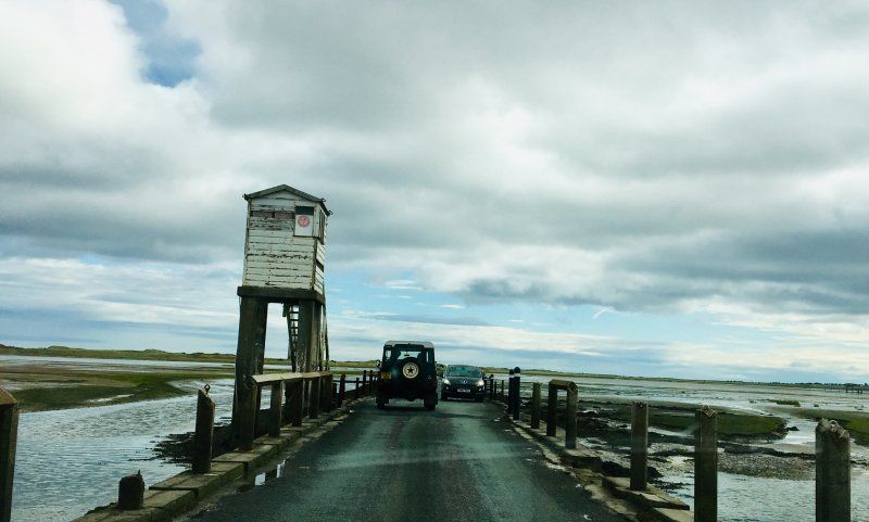
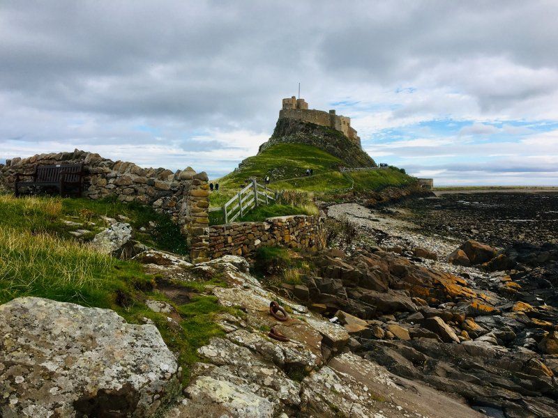
Holy Island, Berwick-upon-Tweed, Vereinigtes Königreich
We're still making a detour to England. We drive to Holy Island an island which can only be reached without a boat at low tide.
Holy Island, Berwick-upon-Tweed TD15 2SD, Vereinigtes Königreich
55° 40' 16.5" N 1° 48' 7.3" W
55.6712390 -1.8020390
• Head toward Crossgate Lane on Marygate. Go for 66 m.
• Turn left onto Chare Ends. Go for 752 m.
• Continue on Lindisfarne Causeway. Go for 6.0 km.
• Turn right onto Beal. Go for 1.2 km.
• Continue on West Mains. Go for 536 m.
• Turn right onto A1. Go for 9.1 km.
• Take the 1st exit from roundabout onto A1 toward Edinburgh. Go for 3.4 km.
• Take the 2nd exit from roundabout onto A1 toward Edinburgh/Berwick Train Station. Go for 4.0 km.
• Take the 2nd exit from roundabout onto A1 toward Edinburgh. Go for 14.4 km.
• Turn right onto B6438 toward Coldingham/St Abbs. Go for 1.3 km.
• Continue on Cairncross (B6438). Go for 159 m.
• Continue on B6438. Go for 2.0 km.
• Continue on Reston Road (B6438). Go for 494 m.
• Turn left onto Bridge Street (A1107). Go for 132 m.
• Turn right onto High Street (B6438). Go for 168 m.
• Continue on Fishers Brae (B6438). Go for 152 m.
• Continue on St Abbs Road (B6438). Go for 2.1 km.
• Turn left onto The Harbour. Go for 120 m.
• Turn left. Go for 32 m.
• Arrive at your destination on the right.
☍
46,2 km
( 40 min.)
Day
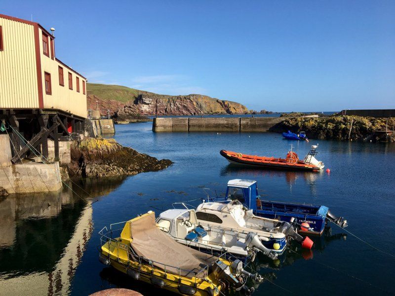
Saint Abbs
Before we leave for Edinburgh around noon, we visit the harbor in St. Abbs.
Rock House, Eyemouth TD14 5PW, UK
55° 53' 56.4" N 2° 7' 50.4" W
55.8990026 -2.1306617
• Head toward The Harbour. Go for 32 m.
• Turn right onto The Harbour. Go for 120 m.
• Turn right onto St Abbs Road (B6438). Go for 2.1 km.
• Continue on Fishers Brae (B6438). Go for 152 m.
• Continue on High Street (B6438). Go for 168 m.
• Turn right onto School Road (A1107). Go for 13.8 km.
• Turn right onto A1 toward Edinburgh. Go for 2.7 km.
• Pass 4 roundabouts and continue on Milton Link (A1). Go for 51.4 km.
• Turn left onto Milton Road (A1) toward City Centre. Go for 3.6 km.
• Turn left onto London Road (A1). Go for 1.3 km.
• Turn slightly left onto Montrose Terrace (A1). Go for 980 m.
• Take the 1st exit from roundabout onto Regent Road (A1). Go for 391 m.
• Arrive at Waterloo Place (A1). Your destination is on the left.
☍
76,8 km
( 56 min.)
Edinburgh, Vereinigtes Königreich
In the afternoon we arrive in Edinburgh, where we get one of the last seats on the club area of the Caravan Club.
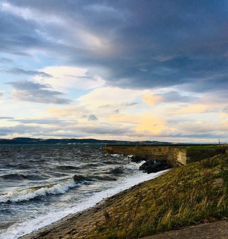
In the evening we go for a walk on the Firth of Forth.
55° 57' 11.7" N 3° 11' 17.8" W
55.9532520 -3.1882670
• Head toward Leith Street on Waterloo Place (A1). Go for 48 m.
• Turn left onto North Bridge (A7). Go for 1.7 km.
• Continue on Newington Road (A701). Go for 5.8 km.
• Take the 3rd exit from roundabout onto Straiton Road (A701) toward Forth Road Bridge/(A90)/Glasgow/(M8)/Stirling/(M9)/A720/Peebles/(A702)/Edinburgh West & North/Airport/Loanhead/Straiton/Bilston/Penicuik. Go for 296 m.
• Turn left onto Straiton Road (A701) toward Peebles/Penicuik/Bilston/(A703). Go for 695 m.
• Take the 2nd exit from roundabout onto Straiton Road (A701). Go for 1.7 km.
• Take the 1st exit from roundabout onto Bilston Cottages (B7006). Go for 121 m.
• Continue on B7006. Go for 922 m.
• Continue on Main Street (B7006). Go for 653 m.
• Turn slightly left onto Chapel Loan. Go for 257 m.
• Turn slightly right. Go for 60 m.
• Arrive at your destination on the right.
☍
12,2 km
( 18 min.)
Day
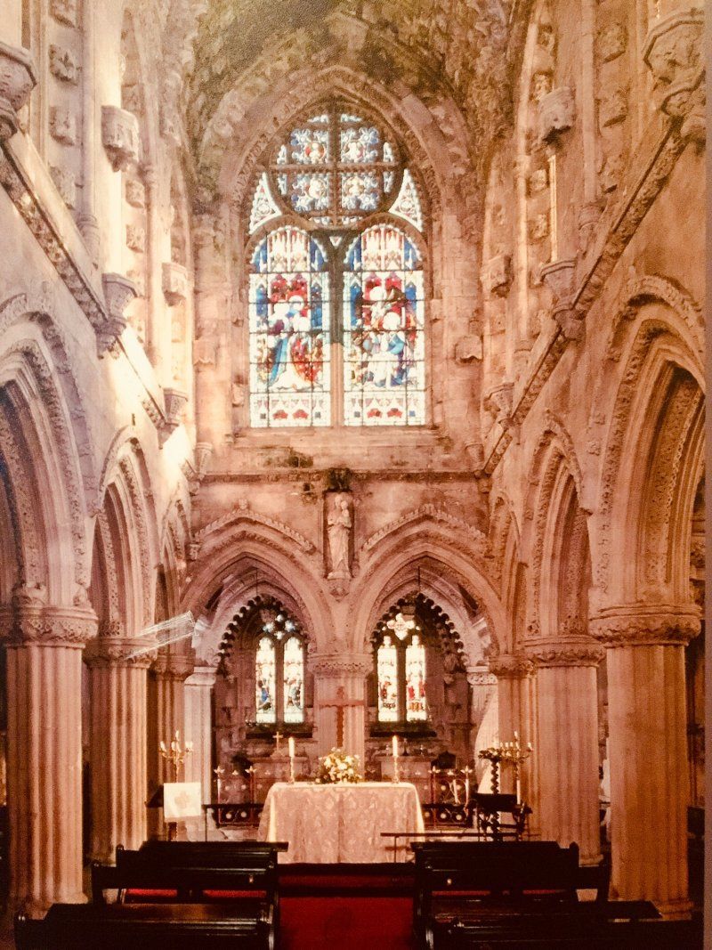
Rosslyn Chapel
Great Britain
55° 51' 18.1" N 3° 9' 32.6" W
55.8550200 -3.1590447
• Head northeast. Go for 21 m.
• Turn slightly left. Go for 73 m.
• Turn left toward Chapel Loan. Go for 36 m.
• Turn slightly right onto Chapel Loan. Go for 257 m.
• Turn slightly right onto Main Street (B7006). Go for 653 m.
• Continue on B7006. Go for 922 m.
• Continue on Bilston Cottages (B7006). Go for 100 m.
• Take the 2nd exit from roundabout onto A701. Go for 1.7 km.
• Pass 2 roundabouts and continue on Burdiehouse Road (A701). Go for 6.8 km.
• Turn left onto West Preston Street (A700). Go for 151 m.
• Turn right onto Summerhall Place (A700). Go for 178 m.
• Continue on Hope Park Crescent. Go for 87 m.
• Continue on Buccleuch Street. Go for 323 m.
• Continue on Chapel Street. Go for 115 m.
• Continue on Potterrow. Go for 409 m.
• Continue on Teviot Place. Go for 57 m.
• Keep right onto Forrest Road. Go for 118 m.
• Keep left onto George IV Bridge. Go for 364 m.
• Turn left onto Lawnmarket. Go for 114 m.
• Take the 3rd exit from roundabout onto Castlehill. Go for 427 m.
• Turn left. Go for 76 m.
• Arrive at your destination on the left.
☍
13,0 km
( 20 min.)
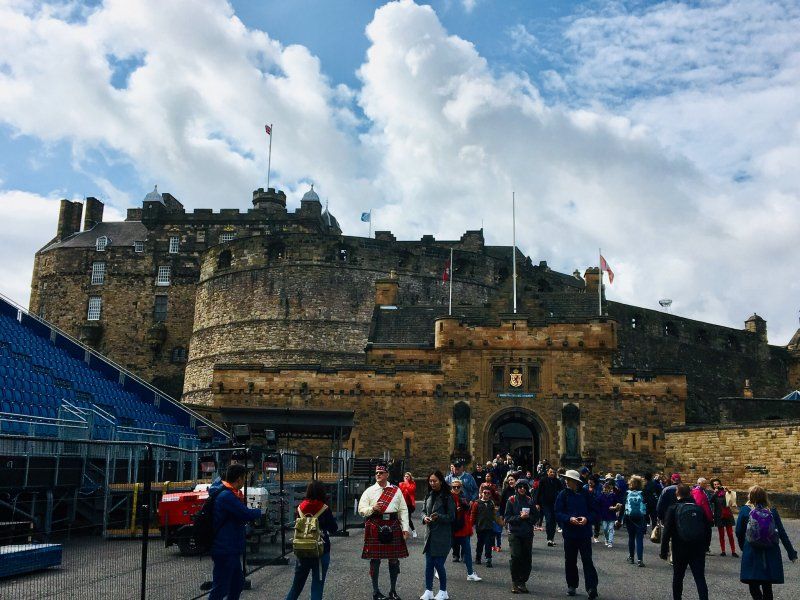
Edinburgh Castle
55° 56' 54.3" N 3° 12' 1.7" W
55.9484097 -3.2004855
• Head west. Go for 76 m.
• Turn right toward Esplanade. Go for 52 m.
• Turn slightly left onto Esplanade. Go for 348 m.
• Take the 1st exit from roundabout onto Lawnmarket. Go for 123 m.
• Turn left onto Bank Street. Go for 181 m.
• Continue on The Mound. Go for 288 m.
• Continue on Hanover Street. Go for 161 m.
• Take the 2nd exit from roundabout onto Hanover Street. Go for 188 m.
• Turn right onto Queen Street. Go for 333 m.
• Continue on York Place. Go for 341 m.
• Continue on Broughton Street (A900). Go for 45 m.
• Turn left onto Picardy Place (A900). Go for 205 m.
• Turn right onto London Road (B1350) toward Berwick upon Tweed/(A1). Go for 801 m.
• Continue on London Road (B1350). Go for 1.1 km.
• Turn right onto Meadowbank. Go for 189 m.
• Turn slightly left onto Dukes Walk. Go for 173 m.
• Turn left onto Queens Drive. Go for 37 m.
• Turn left onto Queens Drive. Go for 2.9 km.
• Arrive at Queens Drive.
☍
7,5 km
( 18 min.)
Day
Holyrood-Park
The Dasses, Edinburgh EH8 8HG, UK
55° 56' 47.3" N 3° 9' 46.8" W
55.9464820 -3.1629901
• Head west on Queens Drive. Go for 185 m.
• Take the 2nd exit from roundabout onto Queens Drive. Go for 1.2 km.
• Take the 2nd exit from roundabout onto Queens Drive. Go for 201 m.
• Take the 1st exit from roundabout onto Horse Wynd. Go for 318 m.
• Turn left onto Abbeyhill. Go for 9 m.
• Take the 2nd exit from roundabout onto Abbeyhill. Go for 291 m.
• Continue on Abbeymount. Go for 190 m.
• Continue on Easter Road. Go for 1.5 km.
• Turn left onto Duke Street. Go for 332 m.
• Continue on Great Junction Street (A901). Go for 1.0 km.
• Turn slightly right onto Ocean Drive toward The Port of Leith/Victoria Quay/Ocean Terminal. Go for 148 m.
• Turn left onto Ocean Drive. Go for 99 m.
• Turn right. Go for 317 m.
• Arrive at your destination on the left.
☍
5,7 km
( 13 min.)
HMS Britannia
Ocean Terminal
55° 58' 55.7" N 3° 10' 38.5" W
55.9821451 -3.1773579
• Head toward Ocean Drive. Go for 219 m.
• Continue on Ocean Drive. Go for 108 m.
• Turn right onto Ocean Drive. Go for 437 m.
• Turn slightly left onto Portland Place (A901). Go for 316 m.
• Turn right onto Ferry Road (A902) toward Forth Road Bridge/(A90)/Glasgow/(M8). Go for 3.7 km.
• Take the 2nd exit from Crewe Toll Roundabout roundabout onto Telford Road (A902) toward Drylaw/Craigleith/Forth Road Bridge/(A90)/City Bypass/(A720). Go for 1.9 km.
• Turn slightly right onto Hillhouse Road (A90) toward Forth Road Bridge/City Bypass/(A720)/Davidson's Mains/Queensferry/Airport. Go for 6.1 km.
• Take ramp toward S. Queensferry/Dalmeny. Go for 262 m.
• Continue on B924. Go for 2.3 km.
• Continue on Hawes Brae (B924). Go for 516 m.
• Continue on Newhalls Road (B924). Go for 527 m.
• Continue on High Street (B924). Go for 309 m.
• Continue on Hopetoun Road (B924). Go for 149 m.
• Turn right onto Shore Road. Go for 258 m.
• Arrive at Shore Road. Your destination is on the right.
☍
17,0 km
( 24 min.)
Forth Brigdes
40/18 Shore Rd, South Queensferry EH30 9RE, UK
55° 59' 31.1" N 3° 24' 12.5" W
55.9919732 -3.4034787
• Head toward Hopetoun Road on Shore Road. Go for 258 m.
• Turn right onto Hopetoun Road (B924). Go for 316 m.
• Continue on Bo'Ness Road (B924). Go for 1.1 km.
• Continue on B924. Go for 106 m.
• Turn right onto Builyeon Road (A904). Go for 79 m.
• Take the 2nd exit from roundabout onto A904. Go for 9.4 km.
• Turn left onto A803. Go for 2.4 km.
• Pass 2 roundabouts and continue on High Street (A803). Go for 988 m.
• Turn right onto Kirkgate. Go for 130 m.
• Arrive at Kirkgate. Your destination is on the right.
☍
14,8 km
( 16 min.)
Linlithgow Palace
1-3 Kirkgate, Linlithgow EH49 7AL, UK
55° 58' 42.5" N 3° 36' 2.9" W
55.9784756 -3.6008010
• Head south on Kirkgate. Go for 130 m.
• Turn right onto High Street (A803). Go for 755 m.
• Take the 2nd exit from roundabout onto Falkirk Road (A803). Go for 4.8 km.
• Take the 3rd exit from Lathallan Interchange roundabout onto M9 toward Stirling. Go for 11.4 km.
• Keep left onto M876 toward Glasgow. Go for 8.4 km.
• Continue on M80. Go for 12.2 km.
• Take exit 4 toward Moodiesburn/(A80). Go for 635 m.
• Take the 2nd exit from roundabout toward Glasgow/Stirling/Kincardine Bridge/(M80)/Moodiesburn. Go for 594 m.
• Turn right onto Mollins Road. Go for 926 m.
• Take the 1st exit from Deerdykes Roundabout roundabout onto Mollins Road. Go for 539 m.
• Turn left onto Gartshore Road. Go for 782 m.
• Turn left. Go for 39 m.
• Arrive at your destination on the right.
☍
41,2 km
( 28 min.)
Day
Barbeth Farm
We leave Edinburgh and drive to Barbeth Farm near Glasgow
Gartshore Rd, Glasgow, UK
55° 55' 47.3" N 4° 4' 28.7" W
55.9298137 -4.0746459
• Head toward Gartshore Road. Go for 39 m.
• Turn right onto Gartshore Road. Go for 782 m.
• Turn right onto Mollins Road. Go for 513 m.
• Take the 1st exit from Deerdykes Roundabout roundabout onto Westfield Road. Go for 2.1 km.
• Pass 2 roundabouts and continue on Westfield Road (B802). Go for 687 m.
• Take the 4th exit from Craiglinn Roundabout roundabout onto B8048. Go for 451 m.
• Take the 1st exit from Back O Hill Roundabout roundabout onto B8048 toward Glasgow/Stirling/(A80). Go for 717 m.
• Take the 1st exit from roundabout onto M80 toward Stirling/A80/(M80)/Kincardine Br./(M876)/Cumbernauld Airport. Go for 8.9 km.
• Keep left onto M876 toward Kincardine Bridge/Falkirk/Grangemouth. Go for 3.4 km.
• Take exit 1 toward Falkirk/Denny. Go for 230 m.
• Turn left onto A883 toward Falkirk/Bonnybridge. Go for 471 m.
• Take the 2nd exit from Checkbar Roundabout roundabout onto A883. Go for 2.1 km.
• Take the 1st exit from Three Bridges roundabout onto Glasgow Road (A803). Go for 1.5 km.
• Take the 2nd exit from Camelon Roundabout roundabout onto Main Street (A803). Go for 729 m.
• Take the 2nd exit from Rosebank Roundabout roundabout onto Camelon Road (A803). Go for 115 m.
• Take the 1st exit from roundabout onto Camelon Road (A803). Go for 1.0 km.
• Keep left onto Upper Newmarket Street (A803). Go for 57 m.
• Turn left onto A803. Go for 381 m.
• Arrive at Garrison Place (A803). Your destination is on the right.
☍
24,2 km
( 22 min.)
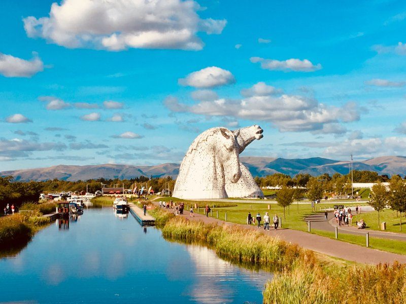
Falkirk, Vereinigtes Königreich
In the afternoon, in bright sunshine, it goes to Falkirk to the Falkirk Wheel and in the Helix Park to the Kelpies
56° 0' 6.8" N 3° 47' 2.1" W
56.0018775 -3.7839131
• Head northeast.
• Take the 2nd exit from roundabout onto Park Street (A803). Go for 207 m.
• Keep left onto Park Street (A803). Go for 323 m.
• Continue on Kerse Lane (A904). Go for 1.5 km.
• Pass 2 roundabouts. Go for 1.1 km.
• Take ramp onto M9. Go for 21.1 km.
• Take exit 10 toward Callander/(A85). Go for 561 m.
• Pass 2 roundabouts and continue on A84. Go for 6.0 km.
• Turn left toward Gargunnock. Go for 33 m.
• Turn left onto Kirk Lane (B8075). Go for 3.5 km.
• Turn right onto A811. Go for 5.0 km.
• Take the 2nd exit from Kippen Station Roundabout roundabout onto A811 toward Erskine Br. Go for 15.5 km.
• Turn left onto A81 toward Glasgow. Go for 143 m.
• Keep left onto A81 toward Glasgow. Go for 5.7 km.
• Take the 3rd exit from Blane Smithy Roundabout roundabout onto B834. Go for 129 m.
• Take the 1st exit from roundabout onto B834. Go for 1.5 km.
• Turn left onto A809. Go for 162 m.
• Arrive at A809.
☍
62,6 km
( 47 min.)
Day
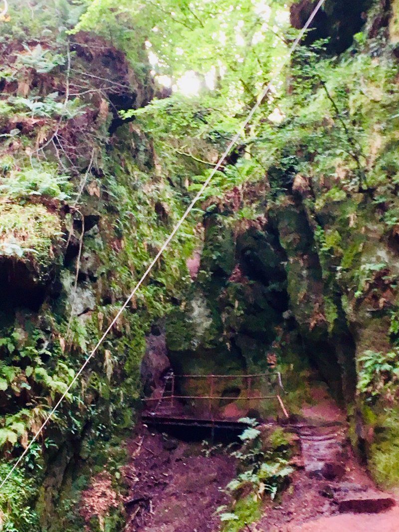
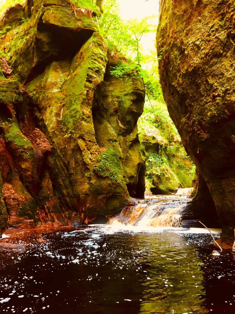
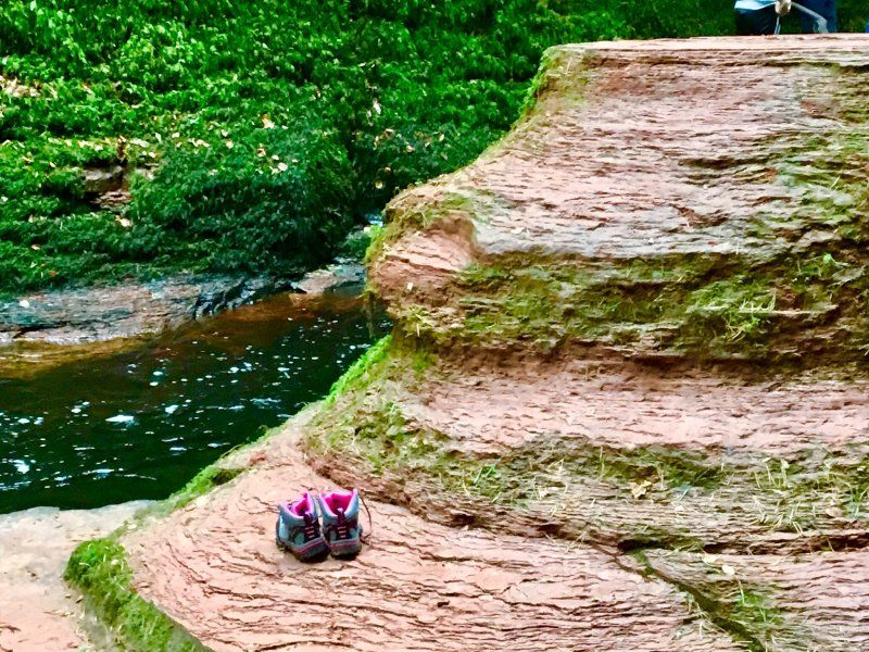
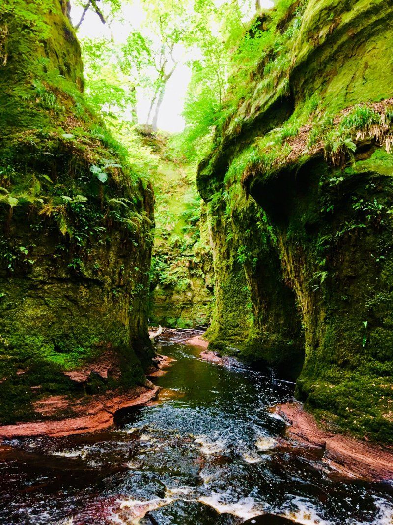
The Devils Pulpit
The weather holds and we drive to the Devils Pulpit. Finding the descent into the gorge is a bit difficult as there are no signposts.
A809, Glasgow G63 9QL, UK
56° 1' 59.7" N 4° 24' 57.1" W
56.0332395 -4.4158552
• Head south on A809. Go for 6.4 km.
• Turn left onto Cuilts Road (B821). Go for 637 m.
• Continue on Station Road (B821). Go for 2.7 km.
• Turn right onto Glasgow Road (A81). Go for 816 m.
• Take the 2nd exit from roundabout onto Glasgow Road (A81). Go for 198 m.
• Take the 1st exit from roundabout onto Campsie Road (A891). Go for 5.9 km.
• Pass 2 roundabouts and continue on Whitefield Terrace (A891). Go for 6.8 km.
• Turn left onto A803. Go for 4.3 km.
• Pass 2 roundabouts and continue on Parkfoot Street (A803). Go for 1.0 km.
• Turn left onto Takmadoon Road. Go for 2.8 km.
• Arrive at Takmadoon Road. Your destination is on the right.
☍
31,6 km
( 36 min.)
Tal Na Doon Road
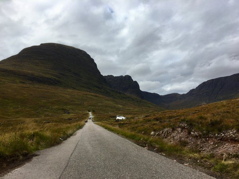
Here we got a foretaste of the single track roads in the Highlands
Great Britain
55° 59' 51.4" N 4° 2' 16.3" W
55.9976031 -4.0378524
• Head southwest on Takmadoon Road. Go for 2.8 km.
• Turn left onto Stirling Road (A803). Go for 6.4 km.
• Pass 2 roundabouts and continue on Kilsyth Road (A803). Go for 673 m.
• Turn left and take ramp onto M80 toward Stirling/Kincardine BR./M876. Go for 12.2 km.
• Continue on M9. Go for 5.4 km.
• Take exit 10 toward Stirling. Go for 561 m.
• Take the 3rd exit from Craigforth Roundabout roundabout onto A84 toward Stirling. Go for 714 m.
• Take the 3rd exit from roundabout onto A84 toward Stirling/Erskine Bridge/Castle Business Park/(A811). Go for 381 m.
• Take the 2nd exit from roundabout onto A84 toward City Centre/Erskine Br./(A811). Go for 901 m.
• Take the 2nd exit from roundabout onto Raploch Road (A811) toward Ring Road/Erskine Br. Go for 83 m.
• Turn left onto Ballengeich Road. Go for 423 m.
• Turn slightly right onto Ballengeich Pass. Go for 186 m.
• Arrive at Ballengeich Pass. Your destination is on the right.
☍
30,7 km
( 25 min.)
Day
Stirling Castle
Outer Close, Great Hall FK8 1EJ, United Kingdom
56° 7' 28.4" N 3° 56' 51.2" W
56.1245429 -3.9475635
• Head northwest on Ballengeich Pass. Go for 186 m.
• Turn slightly left onto Ballengeich Road. Go for 423 m.
• Turn right onto Raploch Road (A811). Go for 50 m.
• Take the 1st exit from roundabout onto A84 toward Motorway/(M9)/(M80)/Crianlarich/(A85)/Castle Business Park/Forth Valley College. Go for 888 m.
• Take the 2nd exit from roundabout onto A84 toward Perth/(M9)/Crianlarich/(A85). Go for 289 m.
• Take the 1st exit from roundabout onto M9 toward Glasgow/(M80)/Edinburgh. Go for 6.3 km.
• Keep right onto M80 toward Glasgow/Carlisle. Go for 21.9 km.
• Take exit 4 toward Moodiesburn/(A80). Go for 635 m.
• Take the 2nd exit from roundabout toward Glasgow/Stirling/Kincardine Bridge/(M80)/Moodiesburn. Go for 594 m.
• Turn left onto Mollins Road. Go for 305 m.
• Continue toward Cumbernauld Road/A80. Go for 38 m.
• Take the 2nd exit from roundabout onto Cumbernauld Road (A80) toward Moodiesburn/Muirhead/Chryston. Go for 1.3 km.
• Turn right onto Stoneyetts Road. Go for 404 m.
• Turn left onto Glenmanor Avenue. Go for 389 m.
• Arrive at Glenmanor Avenue. Your destination is on the right.
☍
33,8 km
( 24 min.)
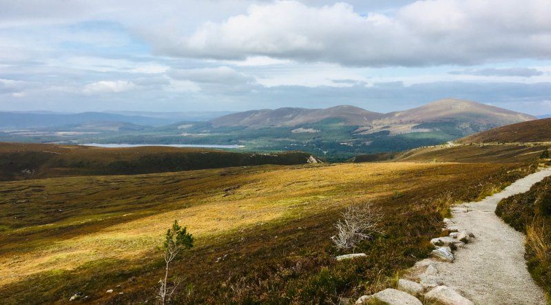
National Wallace Monument
There are 246 steps to the top
Day
Moodiesburn
Since someone drove us into our parked car in Stirling, we have to take a compulsory break for repairs and look around a bit in the vicinity.
Glencairn Drive, Moodiesburn, Glasgow G69 0LB, UK
55° 54' 41.4" N 4° 5' 22.8" W
55.9114951 -4.0896652
• Head west on Glenmanor Avenue. Go for 5 m.
• Turn left onto Glencairn Drive. Go for 183 m.
• Turn left onto Bridgeburn Drive. Go for 499 m.
• Continue on Langdale Road. Go for 127 m.
• Turn right onto Langdale Road. Go for 24 m.
• Turn right onto Stoneyetts Road. Go for 47 m.
• Turn left onto Cumbernauld Road (A80). Go for 1.3 km.
• Take the 1st exit from roundabout toward Carlisle/(M73)/Glasgow/(M80)/Westfield/Mollinsburn. Go for 379 m.
• Continue on Mollins Road. Go for 938 m.
• Take the 2nd exit from Deerdykes Roundabout roundabout onto Westfield Road. Go for 1.7 km.
• Arrive at Westfield Road.
☍
5,2 km
( 7 min.)
Loch Broadwood
Westfield Rd, Cumbernauld, Glasgow G68, UK
55° 56' 12.8" N 4° 2' 31.2" W
55.9368755 -4.0419979
• Head northeast on Westfield Road. Go for 442 m.
• Pass 2 roundabouts and continue on Westfield Road (B802). Go for 687 m.
• Take the 4th exit from Craiglinn Roundabout roundabout onto B8048. Go for 451 m.
• Take the 1st exit from Back O Hill Roundabout roundabout onto B8048 toward Glasgow/Stirling/(A80). Go for 717 m.
• Take the 1st exit from roundabout onto M80 toward Stirling/A80/(M80)/Kincardine Br./(M876)/Cumbernauld Airport. Go for 19.3 km.
• Continue on M9. Go for 9.8 km.
• Take the 2nd exit from roundabout onto A9 toward Perth. Go for 42.3 km.
• Take the 3rd exit from Broxden Roundabout roundabout onto M90 toward Perth City Centre/Broxden/Edinburgh/Dundee/Aberdeen/Coupar Angus/Blairgowrie/Braemar. Go for 4.2 km.
• Take exit 10 toward Dundee/Aberdeen/Coupar Angus/Blairgowrie/Braemar/(A90) onto M90. Go for 3.0 km.
• Continue on A90. Go for 25.0 km.
• Pass 4 roundabouts and continue on Kingsway (A90). Go for 7.6 km.
• Turn left onto Forfar Road (A90) toward Aberdeen/Forfar. Go for 1.3 km.
• Pass 2 roundabouts and continue on Forfar Road (A90). Go for 49.0 km.
• Turn left onto B974 toward Fettercairn/Luthermuir. Go for 5.5 km.
• Continue on Burnside Road (B974). Go for 879 m.
• Turn right onto Main Street (B966). Go for 74 m.
• Take the 1st exit from roundabout onto School Road (B974). Go for 27 m.
• Continue on The Square (B974). Go for 69 m.
• Continue on Cairn O'Mount Road (B974). Go for 249 m.
• Continue on B974. Go for 1.8 km.
• Continue on Old Military Road (B974). Go for 1.2 km.
• Continue on B974. Go for 2.6 km.
• Continue on Clatterin' Brig (B974). Go for 119 m.
• Continue on B974. Go for 9.1 km.
• Continue on Bridge of Dye (B974). Go for 151 m.
• Continue on B974. Go for 271 m.
• Continue on Glendye Lodge (B974). Go for 143 m.
• Continue on B974. Go for 7.2 km.
• Turn right onto B974. Go for 3.9 km.
• Continue on Bridge of Feugh (B974). Go for 197 m.
• Continue on B974. Go for 329 m.
• Continue on Dee Street (B974). Go for 485 m.
• Turn right onto Station Road (A93). Go for 2.1 km.
• Arrive at A93. Your destination is on the left.
☍
200,3 km
(2 hrs. 15 min.)
Day
Day
Silversand Club Site, Banchory
We reach the campsite around noon and are even welcomed in German. Olwyn lived in Hanover for a long time.
Great Britain
57° 3' 27.6" N 2° 28' 18.4" W
57.0576752 -2.4717876
• Head northeast on A93. Go for 3.6 km.
• Turn right onto A957. Go for 18.9 km.
• Take the 2nd exit from roundabout onto Slug Road (A957) toward Stonehaven. Go for 521 m.
• Take the 3rd exit from roundabout onto Farrochie Road. Go for 915 m.
• Turn right onto Auchenblae Road. Go for 208 m.
• Turn left onto Stonehaven Bypass (A90) toward (A92). Go for 1.7 km.
• Take ramp onto A92 toward Montrose/Arbroath. Go for 1.9 km.
• Turn left. Go for 450 m.
• Turn right. Go for 211 m.
• Arrive at your destination.
☍
28,5 km
( 26 min.)
Day
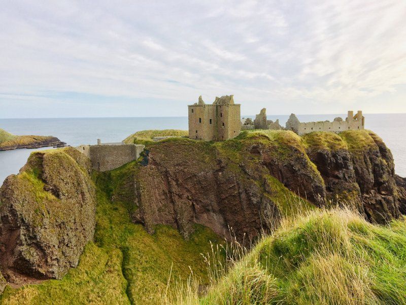
Dunnotar Castle
Unnamed Road, Stonehaven AB39 2TL, UK
56° 56' 45.7" N 2° 11' 46.4" W
56.9460206 -2.1962262
• Head west. Go for 211 m.
• Turn left toward A92. Go for 450 m.
• Turn right onto A92. Go for 1.4 km.
• Turn right onto A957 toward Stonehaven. Go for 2.2 km.
• Turn left onto Evan Street (A957). Go for 291 m.
• Turn right onto Slug Road (A957). Go for 1.5 km.
• Take the 2nd exit from roundabout onto Slug Road (A957). Go for 488 m.
• Take the 1st exit from roundabout onto Slug Road (A957) toward Banchory. Go for 18.9 km.
• Turn left onto A93. Go for 4.8 km.
• Turn right onto Raemoir Road (A980). Go for 3.5 km.
• Turn left onto A980. Go for 12.7 km.
• Continue on Main Road. Go for 90 m.
• Continue on Old Military Road. Go for 77 m.
• Arrive at Old Military Road.
☍
46,7 km
( 47 min.)
Peel Ring of Lumphanan
48 Main Road, Banchory AB31 4PY, UK
57° 7' 34.5" N 2° 41' 33.7" W
57.1262599 -2.6927038
• Head toward Kirk View on Old Military Road. Go for 77 m.
• Continue on Main Road. Go for 12.8 km.
• Turn right onto A980. Go for 3.5 km.
• Turn right onto Station Road (A93). Go for 880 m.
• Turn left onto Dee Street (B974). Go for 485 m.
• Continue on B974. Go for 329 m.
• Continue on Bridge of Feugh (B974). Go for 197 m.
• Turn left. Go for 43 m.
• Arrive at your destination.
☍
18,3 km
( 18 min.)
Falls of Feugh
Footbridge River Feugh, Water of Feugh, United Kingdom
57° 2' 42.2" N 2° 29' 34.2" W
57.0450580 -2.4928460
• Head west. Go for 43 m.
• Turn right onto Bridge of Feugh (B974). Go for 197 m.
• Continue on B974. Go for 329 m.
• Continue on Dee Street (B974). Go for 485 m.
• Turn left onto High Street (A93). Go for 35.6 km.
• Turn right onto Pass of Ballater (B972). Go for 3.0 km.
• Turn right onto A93. Go for 687 m.
• Turn right onto A939. Go for 7.5 km.
• Turn right onto Old Military Road (A939) toward Tomintoul. Go for 9.4 km.
• Turn left onto A939. Go for 18.8 km.
• Turn left onto A939. Go for 423 m.
• Turn right onto Main Street (A939). Go for 19.9 km.
• Turn left onto A95. Go for 1.4 km.
• Take the 1st exit from Speybridge Roundabout roundabout onto A95 toward Perth/(A9)/Inverness/Aviemore/(B9152). Go for 838 m.
• Take the 1st exit from Inverallan Roundabout roundabout onto A95 toward Perth/(A9)/Inverness/Aviemore/(B9152). Go for 2.8 km.
• Turn right onto A938 toward Carrbridge/Skye of Curr/Dulnain Bridge. Go for 14.6 km.
• Turn right onto A9 toward Inverness. Go for 12.5 km.
• Take the 1st exit from roundabout onto A9. Go for 22.3 km.
• Take the 1st exit from Longman Roundabout roundabout onto Longman Road (A82) toward Inverness/FT. William/Longman Ind. Est. Go for 734 m.
• Pass 2 roundabouts and continue on Longman Road (A82). Go for 847 m.
• Take the 1st exit from Shore Street Roundabout roundabout onto Chapel Street (B865) toward Town Centre/Dores/Foyers/(B862). Go for 239 m.
• Turn right onto Friars Lane (B862). Go for 497 m.
• Turn left onto Bridge Street (B861). Go for 129 m.
• Arrive at Castle Street (B861). Your destination is on the left.
☍
153,4 km
(2 hrs. 14 min.)
Day
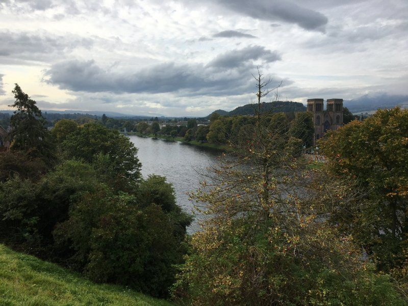
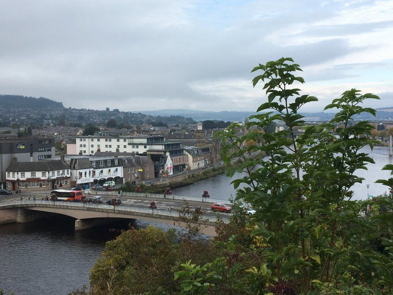
Inverness, Vereinigtes Königreich
57° 28' 40" N 4° 13' 29" W
57.4777730 -4.2247210
• Head southeast on Castle Street (B861). Go for 385 m.
• Turn left onto Old Edinburgh Road (B853). Go for 871 m.
• Turn left onto Damfield Road (B853). Go for 839 m.
• Take the 2nd exit from roundabout onto Old Perth Road (B9006). Go for 546 m.
• Take the 2nd exit from roundabout onto Culloden Road (B9006) toward Culloden Moor/Croy/Perth/(A9). Go for 2.9 km.
• Arrive at Culloden Road (B9006). Your destination is on the right.
☍
5,5 km
( 8 min.)
Ardtower Caravan Park
IV2 5AA, Inverness, Großbritannien
57° 28' 10.2" N 4° 8' 55.3" W
57.4695000 -4.1487000
• Head toward Leanach Gardens on Culloden Road (B9006). Go for 2.5 km.
• Turn right. Go for 555 m.
• Arrive at your destination.
☍
3,1 km
( 3 min.)
Day
Culloden Battlefield
Unnamed Road, Inverness IV2 5BS, UK
57° 28' 17.2" N 4° 6' 18.1" W
57.4714498 -4.1050274
• Head northwest. Go for 555 m.
• Turn right onto B9006. Go for 8.2 km.
• Continue on B9091. Go for 2.4 km.
• Turn left onto Old Military Road (B9090). Go for 1.7 km.
• Continue on B9006. Go for 642 m.
• Turn right onto A96 toward Aberdeen. Go for 40 m.
• Turn left onto B9006. Go for 2.8 km.
• Continue on Station Road (B9006). Go for 520 m.
• Continue on B9006. Go for 106 m.
• Continue on High Street (B9006). Go for 527 m.
• Continue on Old Military Road (B9006). Go for 2.0 km.
• Arrive at Old Military Road (B9006).
☍
19,5 km
( 19 min.)
Fort George
B9006, Inverness IV2 7TE, UK
57° 35' 0.8" N 4° 4' 18.6" W
57.5835516 -4.0718303
• Head east on Old Military Road (B9006). Go for 2.0 km.
• Continue on High Street (B9006). Go for 527 m.
• Continue on B9006. Go for 106 m.
• Continue on Station Road (B9006). Go for 520 m.
• Continue on B9006. Go for 2.8 km.
• Turn right onto A96 toward Inverness. Go for 40 m.
• Turn left onto B9006. Go for 642 m.
• Continue on Old Military Road (B9090). Go for 1.7 km.
• Turn right onto B9091. Go for 2.4 km.
• Continue on B9006. Go for 6.4 km.
• Turn left onto B851. Go for 307 m.
• Turn left. Go for 1.3 km.
• Turn right. Go for 399 m.
• Arrive at your destination on the right.
☍
19,1 km
( 20 min.)
Clara Cairns
Clava, Inverness IV2 5EJ, UK
57° 28' 23.5" N 4° 4' 24.3" W
57.4731836 -4.0734240
• Head northeast. Go for 399 m.
• Turn left toward B9006. Go for 1.5 km.
• Turn left onto B9006. Go for 6.8 km.
• Take the 4th exit from roundabout onto Old Perth Road (B9006) toward Raigmore Hospital/Town Centre/(B865)/Culcabock/Kingmills/Hilton/Culduthel. Go for 626 m.
• Take the 1st exit from roundabout onto Culcabock Road (B853). Go for 854 m.
• Turn right onto Annfield Road (B853). Go for 438 m.
• Turn left onto Southside Road. Go for 68 m.
• Turn right onto Mayfield Road. Go for 357 m.
• Turn right onto Culduthel Road (B861). Go for 2.3 km.
• Take the 2nd exit from roundabout onto Glenurquhart Road (A82). Go for 356 m.
• Take the 3rd exit from Torvean Roundabout roundabout onto A82. Go for 22.4 km.
• Take the 2nd exit from roundabout onto A82. Go for 2.3 km.
• Turn left. Go for 204 m.
• Arrive at your destination.
☍
38,5 km
( 41 min.)
Day
Urquhart Castle
Unnamed Road, Inverness IV63 6XL, UK
57° 19' 27.7" N 4° 26' 30.9" W
57.3243504 -4.4419055
• Head south. Go for 103 m.
• Turn left toward A82. Go for 13 m.
• Turn right onto A82. Go for 2.4 km.
• Pass 3 roundabouts and continue on Glenurquhart Road (A82). Go for 24.1 km.
• Turn left onto Kenneth Street (A82) toward Perth/Thurso/(A9)/Aberdeen/(A96)/Beauly/(A862). Go for 599 m.
• Take the 3rd exit from Telford Street Roundabout roundabout onto A82 toward Aberdeen/Perth/Wick/(A9). Go for 542 m.
• Take the 3rd exit from Shore Street Roundabout roundabout onto Longman Road (A82) toward Aberdeen/Perth/Wick/(A9). Go for 297 m.
• Take the 1st exit from Rose Street Roundabout roundabout onto Longman Road (A82) toward Longman Ind. Est./Dingwall/Ullapool/Aberdeen/Perth/Wick/(A9). Go for 552 m.
• Take the 3rd exit from Harbour Road Roundabout roundabout onto Harbour Road toward Longman Ind. Est. South & East. Go for 336 m.
• Turn left. Go for 81 m.
• Arrive at your destination on the right.
☍
29,1 km
( 29 min.)
Moray Firth Motors
As our car strikes again in trailer mode, we decide to allow the caravan in Inverness and explore with day trips to the north.
32 Harbour Rd, Inverness IV1 1SQ, UK
57° 29' 8.9" N 4° 12' 54" W
57.4858009 -4.2149940
• Head toward Harbour Road. Go for 81 m.
• Turn right onto Harbour Road. Go for 272 m.
• Take the 3rd exit from Harbour Road Roundabout roundabout onto Longman Road (A82) toward Dingwall/Ullapool/Aberdeen/Perth/Wick/(A9)/Longman Ind. Est. North/Nairn. Go for 792 m.
• Take the 3rd exit from Longman Roundabout roundabout onto A9 toward Aberdeen/(A96)/Perth/Nairn. Go for 22.4 km.
• Take the 2nd exit from roundabout onto A9. Go for 43.9 km.
• Turn left onto A86 toward Kingussie/Newtonmore/Spean Bridge/Fort William/(A82). Go for 168 m.
• Turn right onto A86 toward Kingussie/Newtonmore/Spean Br./Fort William/(A82). Go for 4.5 km.
• Arrive at Kingussie Road (A86). Your destination is on the left.
☍
72,1 km
( 48 min.)
Day
Highland Folk Museum
A86, Newtonmore PH20 1AY, UK
57° 4' 12.2" N 4° 6' 7.9" W
57.0700596 -4.1021997
• Head toward Ardvonie Road on Kingussie Road (A86). Go for 4.1 km.
• Turn right and take ramp onto A9 toward Inverness. Go for 21.4 km.
• Turn right onto A95 toward Carrbridge/(B9153)/Grantown on Spey/Elgin/(A941)/Boat of Garten/Nethy Bridge/Keith. Go for 266 m.
• Turn left onto A95 toward Elgin/(A941)/Keith/(A96)/Grantown on Spey/(B9102)/Carrbridge/(B9153). Go for 18.9 km.
• Take the 2nd exit from Inverallan Roundabout roundabout onto A95 toward Elgin/(A941)/Keith/Aberlour/Tomintoul/(A939). Go for 886 m.
• Take the 3rd exit from Speybridge Roundabout roundabout onto A95 toward Keith/Elgin/(A941). Go for 1.4 km.
• Turn right onto A939 toward Braemar/(A93)/Tomintoul. Go for 19.9 km.
• Turn left onto A939. Go for 423 m.
• Turn right onto A939. Go for 18.8 km.
• Turn right onto A939. Go for 9.4 km.
• Turn right onto B976 toward Crathie/Braemar/(A93). Go for 195 m.
• Continue on Gairnshiel Lodge (B976). Go for 84 m.
• Continue on B976. Go for 6.2 km.
• Continue on Bush Crathie (B976). Go for 166 m.
• Continue on B976. Go for 1.4 km.
• Turn right onto A93. Go for 14.0 km.
• Turn right onto Invercauld Road. Go for 91 m.
• Turn slightly right onto Invercauld Road. Go for 69 m.
• Continue on Mar Road. Go for 229 m.
• Continue on Linn of Dee Road. Go for 139 m.
• Turn right onto Linn of Dee Road. Go for 6.7 km.
• Continue on Inverey. Go for 722 m.
• Continue on Muir Cottage. Go for 1.8 km.
• Continue on Muir. Go for 640 m.
• Turn left. Go for 2.4 km.
• Arrive at your destination.
☍
130,4 km
(1 hrs. 55 min.)
Cairngorms National Park
Ballater AB35 5YJ, UK
57° 2' 37.1" N 3° 36' 12.6" W
57.0436356 -3.6034907
• Head east. Go for 2.4 km.
• Turn right toward Muir. Go for 512 m.
• Continue on Muir. Go for 1.9 km.
• Continue on Muir Cottage. Go for 724 m.
• Continue on Inverey. Go for 3.9 km.
• Turn right toward Linn of Dee Road. Go for 2.6 km.
• Continue on Linn of Dee Road. Go for 459 m.
• Continue on Mar Road. Go for 229 m.
• Continue on Invercauld Road. Go for 160 m.
• Turn left onto A93. Go for 14.0 km.
• Turn left onto B976. Go for 1.4 km.
• Continue on Bush Crathie (B976). Go for 166 m.
• Continue on B976. Go for 6.2 km.
• Continue on Gairnshiel Lodge (B976). Go for 84 m.
• Continue on B976. Go for 195 m.
• Turn left onto Old Military Road (A939) toward Tomintoul. Go for 9.4 km.
• Turn left onto A939. Go for 18.8 km.
• Turn left onto A939. Go for 423 m.
• Turn right onto Main Street (A939). Go for 19.9 km.
• Turn left onto A95. Go for 1.4 km.
• Take the 1st exit from Speybridge Roundabout roundabout onto A95 toward Perth/(A9)/Inverness/Aviemore/(B9152). Go for 838 m.
• Take the 1st exit from Inverallan Roundabout roundabout onto A95 toward Perth/(A9)/Inverness/Aviemore/(B9152). Go for 2.8 km.
• Turn right onto A938 toward Carrbridge/Skye of Curr/Dulnain Bridge. Go for 14.6 km.
• Turn right onto A9 toward Inverness. Go for 12.5 km.
• Take the 1st exit from roundabout onto A9. Go for 22.3 km.
• Take the 2nd exit from Longman Roundabout roundabout onto A9 toward Thurso/Ullapool/(A835). Go for 5.4 km.
• Turn right onto B9161. Go for 1.2 km.
• Continue on Millbank Road (B9161). Go for 2.2 km.
• Continue on B9161. Go for 1.1 km.
• Continue on Millbank Road (B9161). Go for 631 m.
• Continue on B9161. Go for 177 m.
• Turn right onto A832. Go for 5.4 km.
• Continue on Toll Road (A832). Go for 85 m.
• Continue on Bridge Street (A832). Go for 123 m.
• Continue on High Street (A832). Go for 236 m.
• Continue on A832. Go for 2.0 km.
• Continue on Canonbury Terrace (A832). Go for 506 m.
• Continue on High Street (A832). Go for 604 m.
• Continue on Rosemarkie Road (A832). Go for 16 m.
• Turn right onto Ness Road. Go for 2.3 km.
• Arrive at Ness Road.
☍
159,8 km
(2 hrs. 22 min.)
Day
Chanonry Point
17 Ness Rd, Fortrose IV10 8SD, UK
57° 34' 26.3" N 4° 5' 33.8" W
57.5739784 -4.0927215
• Head southeast on Ness Road. Go for 18 m.
• Take the 2nd exit from roundabout. Go for 90 m.
• Turn slightly left onto Ness Road. Go for 2.3 km.
• Turn left onto Rosemarkie Road (A832). Go for 16 m.
• Continue on High Street (A832). Go for 604 m.
• Continue on Canonbury Terrace (A832). Go for 506 m.
• Continue on A832. Go for 2.0 km.
• Continue on High Street (A832). Go for 236 m.
• Continue on Bridge Street (A832). Go for 123 m.
• Continue on Toll Road (A832). Go for 85 m.
• Continue on A832. Go for 10.5 km.
• Take the 4th exit from roundabout onto A9. Go for 10.6 km.
• Take the 2nd exit from Ardullie Roundabout roundabout onto A9. Go for 26.5 km.
• Take the 1st exit from Nigg Roundabout roundabout onto A9. Go for 9.9 km.
• Take the 3rd exit from Meikle Ferry Roundabout roundabout onto A9. Go for 51.8 km.
• Take the 2nd exit from roundabout onto A9. Go for 28.5 km.
• Turn left onto A9. Go for 27.9 km.
• Turn left onto A9. Go for 9.2 km.
• Turn right onto A836. Go for 13.2 km.
• Turn left onto B855. Go for 1.5 km.
• Continue on Hunspow (B855). Go for 199 m.
• Continue on B855. Go for 739 m.
• Turn left onto B855. Go for 4.9 km.
• Arrive at your destination on the left.
☍
201,2 km
(2 hrs. 36 min.)
Day
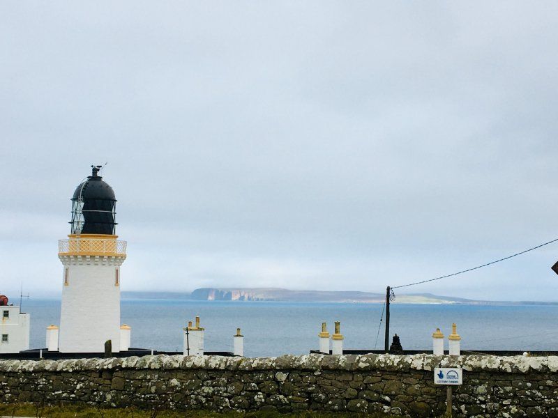
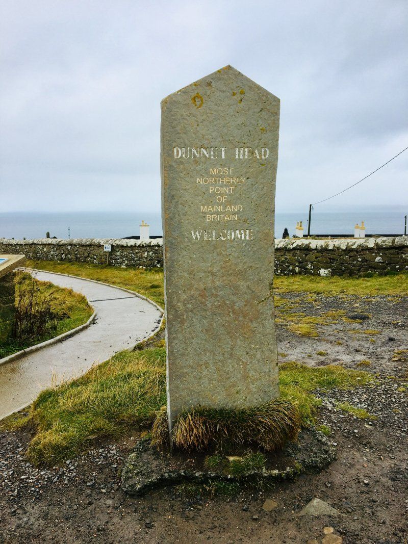
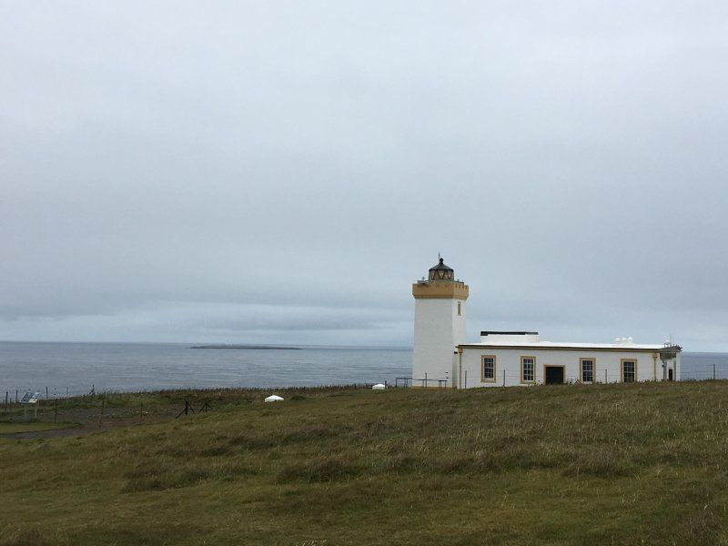
Dunnet Head
Today we went north.
2 Dunnet Head, Dunnet, Thurso KW14 8XS, UK
58° 40' 17.1" N 3° 22' 34.8" W
58.6714253 -3.3763387
• Head east. Go for 148 m.
• Continue on B855. Go for 4.8 km.
• Turn right onto B855. Go for 739 m.
• Continue on Hunspow (B855). Go for 199 m.
• Continue on B855. Go for 1.5 km.
• Turn right onto A836. Go for 13.2 km.
• Turn left onto A9. Go for 9.2 km.
• Turn right onto A9. Go for 27.9 km.
• Turn right onto A9. Go for 28.4 km.
• Take the 1st exit from roundabout onto A9. Go for 51.8 km.
• Take the 1st exit from Meikle Ferry Roundabout roundabout onto A9. Go for 9.9 km.
• Take the 2nd exit from Nigg Roundabout roundabout onto A9. Go for 26.5 km.
• Pass 2 roundabouts and continue on A9. Go for 20.1 km.
• Take the 2nd exit from Longman Roundabout roundabout onto A9 toward Aberdeen/(A96)/Perth/Cairngorms National Park/Nairn. Go for 3.1 km.
• Take ramp onto B9006 toward Culloden/Croy/Raigmore Hospital. Go for 220 m.
• Turn right onto Culloden Road (B9006). Go for 2.3 km.
• Arrive at Culloden Road (B9006). Your destination is on the right.
☍
199,8 km
(2 hrs. 29 min.)
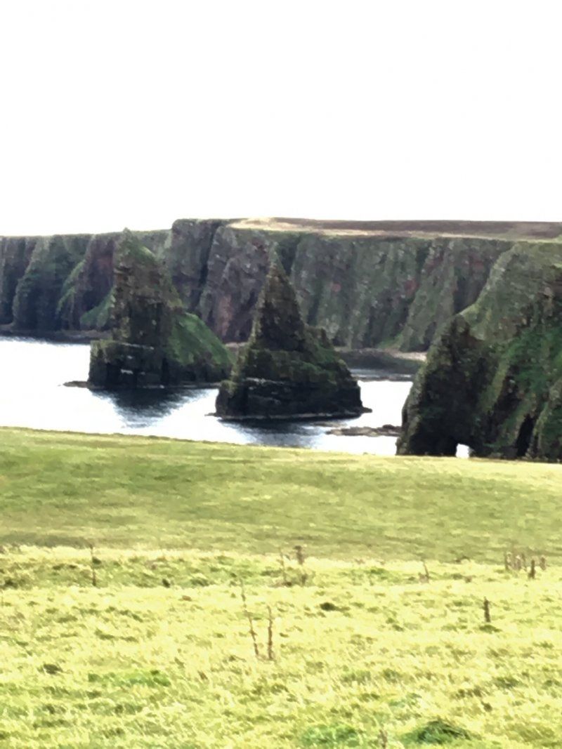
Duncasby Head und Duncasby Staks
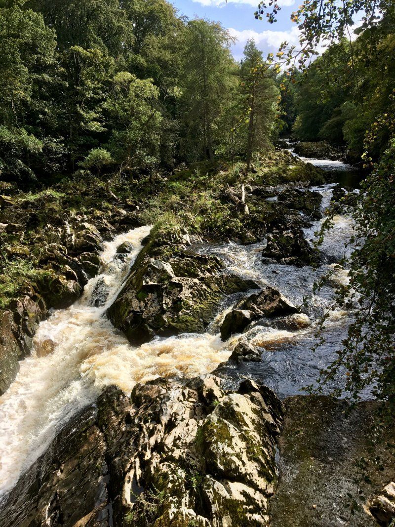
Shin Falls
Salmon can still be seen jumping at Shin Falls in September.
Ardtower Caravan Park
IV2 5AA, Inverness, Großbritannien
57° 28' 10.2" N 4° 8' 55.3" W
57.4695000 -4.1487000
• Head toward Ardtower Road on Culloden Road (B9006). Go for 2.8 km.
• Take the 5th exit from roundabout onto Sir Walter Scott Drive (A8082) toward Longman Ind. Est./Nairn/Ullapool/FT. William/Wick/(A9). Go for 318 m.
• Take ramp onto A9. Go for 2.8 km.
• Take the 2nd exit from Longman Roundabout roundabout onto A9 toward Thurso/Ullapool/(A835). Go for 9.6 km.
• Take the 2nd exit from roundabout onto A835. Go for 8.5 km.
• Take the 2nd exit from roundabout onto A835. Go for 70.7 km.
• Arrive at Garve Road (A835).
☍
94,6 km
(1 hrs. 8 min.)
Day
Ullapool
In bright sunshine and 24 degrees we drive from Inverness to the west coast.
20 Argyle St, Ullapool IV26 2UB, UK
57° 53' 47.9" N 5° 9' 16.7" W
57.8966431 -5.1546335
• Head toward Shore Street on Garve Road (A835). Go for 14 m.
• Turn right onto Mill Street (A835). Go for 337 m.
• Continue on North Road (A835). Go for 592 m.
• Continue on A835. Go for 14.4 km.
• Continue on Drumrunie (A835). Go for 297 m.
• Continue on A835. Go for 12.3 km.
• Turn left onto A837. Go for 7.2 km.
• Continue on Stronchrubie (A837). Go for 137 m.
• Continue on A837. Go for 2.5 km.
• Continue on Inchnadamph (A837). Go for 165 m.
• Continue on A837. Go for 2.0 km.
• Arrive at A837. Your destination is on the right.
☍
39,9 km
( 33 min.)
Loch Assynt
Great Britain
58° 10' 0.3" N 4° 59' 22.2" W
58.1667575 -4.9895088
• Head northwest on A837. Go for 7.5 km.
• Continue on Lochassynt Lodge (A837). Go for 169 m.
• Continue on A837. Go for 9.2 km.
• Turn right onto B869. Go for 2.7 km.
• Continue on Rhicarn (B869). Go for 127 m.
• Continue on B869. Go for 6.5 km.
• Continue on Stoer (B869). Go for 145 m.
• Continue on B869. Go for 1.6 km.
• Continue on Rienachait (B869). Go for 182 m.
• Continue on B869. Go for 1.2 km.
• Continue on Clashnessie (B869). Go for 161 m.
• Continue on B869. Go for 251 m.
• Arrive at B869. Your destination is on the left.
☍
29,9 km
( 30 min.)
Clashnessie Beach
We stopped at Clashnessie Beach. When we wanted to go on, our car didn't start anymore. We needed the tow truck. It was 3 hours piggyback back to Inverness.
Beach, Lairg IV27 4JF, UK
58° 13' 25.2" N 5° 18' 34.6" W
58.2236744 -5.3096050
• Head southwest on B869. Go for 251 m.
• Continue on Clashnessie (B869). Go for 161 m.
• Continue on B869. Go for 1.2 km.
• Continue on Rienachait (B869). Go for 182 m.
• Continue on B869. Go for 1.6 km.
• Continue on Stoer (B869). Go for 145 m.
• Continue on B869. Go for 6.5 km.
• Continue on Rhicarn (B869). Go for 127 m.
• Continue on B869. Go for 2.7 km.
• Turn left onto A837. Go for 9.2 km.
• Continue on Lochassynt Lodge (A837). Go for 169 m.
• Continue on A837. Go for 9.5 km.
• Continue on Inchnadamph (A837). Go for 165 m.
• Continue on A837. Go for 2.5 km.
• Continue on Stronchrubie (A837). Go for 137 m.
• Continue on A837. Go for 9.6 km.
• Continue on Altnacealgach (A837). Go for 199 m.
• Continue on A837. Go for 13.3 km.
• Continue on Lubcroy (A837). Go for 152 m.
• Continue on A837. Go for 2.9 km.
• Continue on Oykel Bridge (A837). Go for 300 m.
• Continue on A837. Go for 9.1 km.
• Continue on Invercassley (A837). Go for 284 m.
• Continue on A837. Go for 12.5 km.
• Keep right onto A837. Go for 1.2 km.
• Turn right onto A836. Go for 1.0 km.
• Continue on Invershin Station (A836). Go for 290 m.
• Continue on A836. Go for 2.9 km.
• Continue on Lairg Road (A836). Go for 2.1 km.
• Continue on A836. Go for 16 m.
• Turn right onto A836. Go for 306 m.
• Continue on South Bonar Industrial Estate (A836). Go for 184 m.
• Continue on A836. Go for 5.7 km.
• Continue on Fearn Lodge (A836). Go for 111 m.
• Continue on A836. Go for 109 m.
• Turn right onto B9176. Go for 8.0 km.
• Continue on Aultnamain Inn (B9176). Go for 168 m.
• Continue on B9176. Go for 8.4 km.
• Continue on Stittenham (B9176). Go for 94 m.
• Continue on B9176. Go for 7.7 km.
• Turn right onto A9. Go for 7.1 km.
• Pass 2 roundabouts and continue on A9. Go for 20.1 km.
• Take the 2nd exit from Longman Roundabout roundabout onto A9 toward Aberdeen/(A96)/Perth/Cairngorms National Park/Nairn. Go for 3.1 km.
• Take ramp onto B9006 toward Culloden/Croy/Raigmore Hospital. Go for 220 m.
• Turn right onto Culloden Road (B9006). Go for 2.3 km.
• Arrive at Culloden Road (B9006). Your destination is on the right.
☍
153,9 km
(2 hrs. 20 min.)
Ardtower Caravan Park
5 Leanach Gardens, Westhill, Inverness IV2 5DD, UK
57° 28' 10.2" N 4° 8' 55.3" W
57.4695000 -4.1487000
• Head toward Ardtower Road on Culloden Road (B9006). Go for 2.8 km.
• Take the 4th exit from roundabout onto Old Perth Road (B9006) toward Raigmore Hospital/Town Centre/(B865)/Culcabock/Kingmills/Hilton/Culduthel. Go for 626 m.
• Take the 1st exit from roundabout onto Culcabock Road (B853). Go for 854 m.
• Turn right onto Annfield Road (B853). Go for 438 m.
• Turn left onto Southside Road. Go for 68 m.
• Turn right onto Mayfield Road. Go for 357 m.
• Turn right onto Culduthel Road (B861). Go for 227 m.
• Turn left onto View Place (B861). Go for 62 m.
• Arrive at View Place (B861). Your destination is on the left.
☍
5,4 km
( 10 min.)
Day
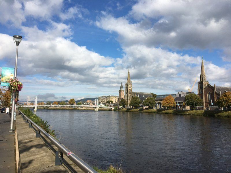
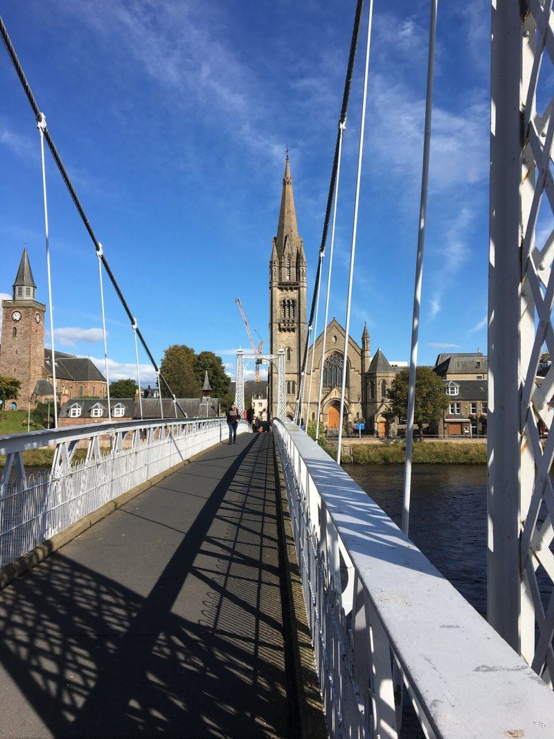
Inverness Castle
We are spending the weekend in Inverness.
2 Culduthel Rd, Inverness IV2 4AB, UK
57° 28' 29.7" N 4° 13' 30.8" W
57.4749196 -4.2252257
• Head toward Haugh Road on View Place (B861). Go for 71 m.
• Turn right onto Castle Road (B862). Go for 315 m.
• Turn left onto Young Street (B861). Go for 166 m.
• Turn right onto King Street. Go for 238 m.
• Turn right onto Greig Street. Go for 83 m.
• Turn right onto Huntly Street. Go for 229 m.
• Arrive at Huntly Street. Your destination is on the right.
☍
1,1 km
( 3 min.)
Day
Inverness
10 Huntly St, Inverness IV3 5PR, UK
57° 28' 37.3" N 4° 13' 43.5" W
57.4770171 -4.2287415
• Head toward Young Street on Huntly Street. Go for 30 m.
• Turn left onto Young Street (B861). Go for 98 m.
• Turn left onto Bank Street (B862). Go for 497 m.
• Turn right onto Academy Street (B865). Go for 401 m.
• Arrive at Academy Street (B865). Your destination is on the right.
☍
1,0 km
( 3 min.)
Day
Inverness
2-6 Eastgate, Inverness IV2 3NA, UK
57° 28' 41.3" N 4° 13' 21.9" W
57.4781406 -4.2227589
• Head toward Baron Taylor's Street on Academy Street (B865). Go for 634 m.
• Take the 4th exit from Shore Street Roundabout roundabout onto Longman Road (A82) toward Aberdeen/Perth/Wick/(A9)/Longman Ind. Est./Airport. Go for 333 m.
• Take the 1st exit from Rose Street Roundabout roundabout onto Longman Road (A82) toward Longman Ind. Est./Dingwall/Ullapool/Aberdeen/Perth/Wick/(A9). Go for 552 m.
• Take the 3rd exit from Harbour Road Roundabout roundabout onto Harbour Road toward Longman Ind. Est. South & East. Go for 336 m.
• Turn left. Go for 81 m.
• Arrive at your destination on the right.
☍
1,9 km
( 4 min.)
Day
Moray Firth Motors
Monday it's back to the workshop. James notices that the fuel pump is broken. He has to order it and can't fix our car until the next day.
32 Harbour Rd, Inverness IV1 1SQ, UK
57° 29' 9" N 4° 12' 53.9" W
57.4858247 -4.2149671
• Head toward Harbour Road. Go for 81 m.
• Turn right onto Harbour Road. Go for 272 m.
• Take the 1st exit from Harbour Road Roundabout roundabout onto Longman Road (A82) toward Fort William/Town Centre/Carse Ind. Est. Go for 553 m.
• Pass 3 roundabouts and continue on Kenneth Street (A82). Go for 1.4 km.
• Turn right onto Tomnahurich Street (A82) toward Fort William. Go for 1.4 km.
• Take the 2nd exit from roundabout onto Glenurquhart Road (A82). Go for 356 m.
• Take the 3rd exit from Torvean Roundabout roundabout onto A82. Go for 22.4 km.
• Take the 2nd exit from roundabout onto A82. Go for 19.5 km.
• Turn right onto A887 toward Caol Loch Aillse/Kyle of Lochalsh/(A87). Go for 24.3 km.
• Continue on A87. Go for 33.1 km.
• Arrive at A87. Your destination is on the left.
☍
103,2 km
(1 hrs. 30 min.)
Day
Shiel Bridge
The car is running again and we hook up the trailer and drive towards Skye. However, we do not go straight to the island but make a stop in Shiel Bridge, from where we drive over the Bealach na Ba to Appelcross.
Junction, Kyle IV40 8HW, UK
57° 12' 49.3" N 5° 25' 6.5" W
57.2136926 -5.4184747
• Head west on A87. Go for 16.3 km.
• Turn right onto A890. Go for 23.5 km.
• Turn left onto A896. Go for 2.5 km.
• Continue on Kirkton (A896). Go for 58 m.
• Continue on A896. Go for 431 m.
• Continue on Main Street (A896). Go for 418 m.
• Continue on A896. Go for 16 m.
• Continue on Main Street (A896). Go for 1.8 km.
• Continue on A896. Go for 6.8 km.
• Continue on Sanachan (A896). Go for 136 m.
• Continue on A896. Go for 1.0 km.
• Continue on Kishorn (A896). Go for 62 m.
• Continue on A896. Go for 1.6 km.
• Turn left. Go for 17.9 km.
• Turn slightly right. Go for 18 m.
• Arrive at your destination.
☍
72,7 km
(1 hrs. 15 min.)
Shiel Bridge Caravan und Camping Park
Applecross, Strathcarron, Vereinigtes Königreich
57° 25' 54.8" N 5° 48' 35" W
57.4319012 -5.8097270
• Head southeast. Go for 18.0 km.
• Turn right onto A896. Go for 1.6 km.
• Continue on Kishorn (A896). Go for 62 m.
• Continue on A896. Go for 1.0 km.
• Continue on Sanachan (A896). Go for 136 m.
• Continue on A896. Go for 6.8 km.
• Continue on Main Street (A896). Go for 1.8 km.
• Continue on A896. Go for 16 m.
• Continue on Main Street (A896). Go for 418 m.
• Continue on A896. Go for 431 m.
• Continue on Kirkton (A896). Go for 58 m.
• Continue on A896. Go for 2.5 km.
• Turn right onto A890. Go for 23.4 km.
• Turn right toward A87. Go for 50 m.
• Continue on A87. Go for 1.3 km.
• Continue on Kirkton (A87). Go for 136 m.
• Continue on A87. Go for 7.2 km.
• Continue on Station Road (A87). Go for 275 m.
• Continue on A87. Go for 1.8 km.
• Continue on Skye Bridge (A87). Go for 480 m.
• Continue on A87. Go for 135 m.
• Take the 3rd exit from roundabout onto A87. Go for 6.1 km.
• Continue on Ashaig (A87). Go for 78 m.
• Continue on A87. Go for 3.2 km.
• Continue on Moorlands (A87). Go for 205 m.
• Continue on A87. Go for 725 m.
• Continue on Harrapool (A87). Go for 230 m.
• Continue on A87. Go for 551 m.
• Continue on Limepark Terrace (A87). Go for 58 m.
• Continue on A87. Go for 3.9 km.
• Continue on Scalpay Ho (A87). Go for 207 m.
• Continue on A87. Go for 3.9 km.
• Continue on Dunan (A87). Go for 122 m.
• Continue on A87. Go for 18.5 km.
• Continue on Sligachan Hotel (A87). Go for 121 m.
• Continue on Sligachan (A87). Go for 69 m.
• Continue on A87. Go for 13.7 km.
• Continue on Viewfield Road (A87). Go for 680 m.
• Continue on Bridge Road (A855). Go for 384 m.
• Continue on The Green (A855). Go for 182 m.
• Turn left onto Bank Street (A855). Go for 236 m.
• Continue on Mill Road (A855). Go for 111 m.
• Keep left onto Staffin Road (A855). Go for 1.0 km.
• Continue on A855. Go for 4.7 km.
• Continue on Fada (A855). Go for 256 m.
• Continue on A855. Go for 7.8 km.
• Arrive at A855.
☍
134,6 km
(2 hrs. 17 min.)
Day
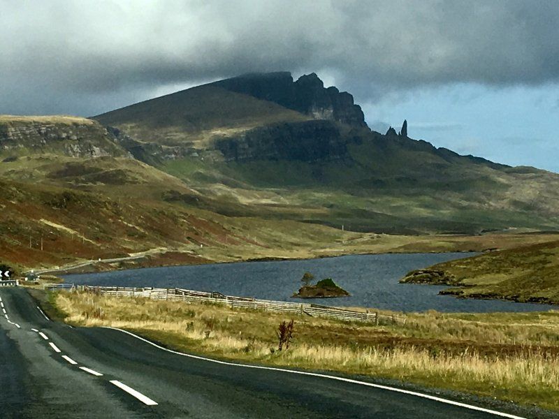
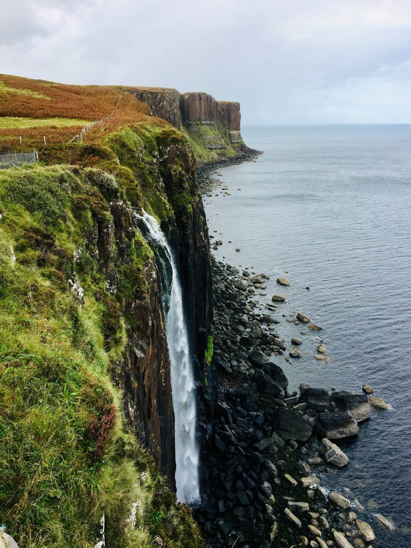
Skye, Vereinigtes Königreich
57° 32' 9.3" N 6° 13' 34.6" W
57.5359261 -6.2262725
• Head south on A855. Go for 7.8 km.
• Continue on Fada (A855). Go for 256 m.
• Continue on A855. Go for 4.7 km.
• Continue on Staffin Road (A855). Go for 1.0 km.
• Continue on Mill Road (A855). Go for 111 m.
• Continue on Bosville Terrace (A855). Go for 236 m.
• Turn right onto The Green (A855). Go for 182 m.
• Continue on Bridge Road (A855). Go for 384 m.
• Continue on Viewfield Road (A87). Go for 680 m.
• Continue on A87. Go for 2.2 km.
• Turn right onto A87. Go for 11.6 km.
• Continue on Sligachan (A87). Go for 69 m.
• Turn right. Go for 97 m.
• Arrive at your destination on the left.
☍
29,3 km
( 30 min.)
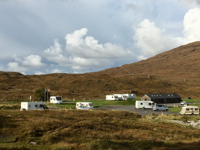
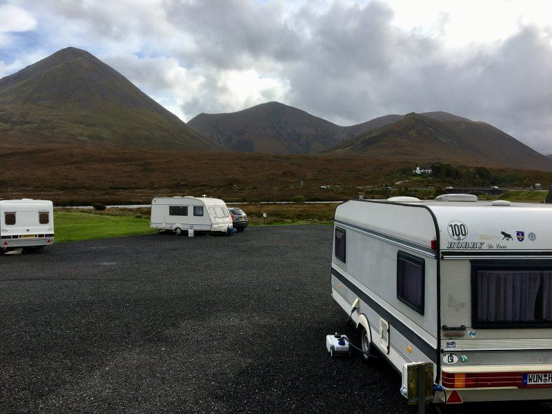
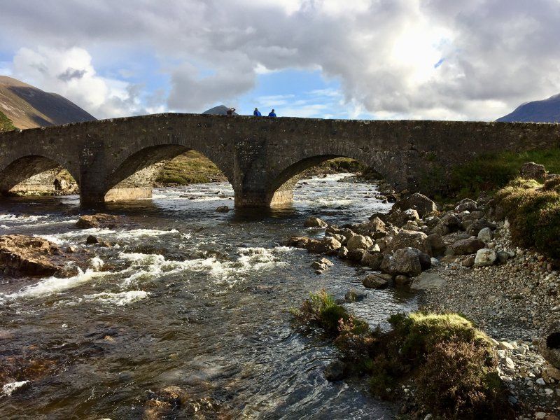
Sligachan Campsite
IV47 8SW, Sligachan, Großbritannien
57° 17' 24.4" N 6° 10' 30" W
57.2901000 -6.1750000
• Head southeast. Go for 78 m.
• Turn left onto A863. Go for 67 m.
• Turn left onto Sligachan Hotel (A87). Go for 121 m.
• Continue on Sligachan (A87). Go for 69 m.
• Continue on A87. Go for 13.7 km.
• Continue on Viewfield Road (A87). Go for 680 m.
• Continue on Bridge Road (A855). Go for 384 m.
• Continue on The Green (A855). Go for 182 m.
• Turn left onto Bank Street (A855). Go for 236 m.
• Continue on Mill Road (A855). Go for 111 m.
• Keep left onto Staffin Road (A855). Go for 1.0 km.
• Continue on A855. Go for 4.7 km.
• Continue on Fada (A855). Go for 256 m.
• Continue on A855. Go for 1.7 km.
• Arrive at A855. Your destination is on the right.
☍
23,4 km
( 24 min.)
Old Man of Storr
A855, Portree IV51 9HX, UK
57° 28' 46" N 6° 10' 46.9" W
57.4794545 -6.1796898
• Head north on A855. Go for 9.6 km.
• Continue on Upper Tote (A855). Go for 122 m.
• Continue on A855. Go for 481 m.
• Continue on Lealt Falls House (A855). Go for 291 m.
• Continue on A855. Go for 3.7 km.
• Continue on Valtos (A855). Go for 169 m.
• Continue on A855. Go for 1.6 km.
• Turn right. Go for 133 m.
• Turn right. Go for 83 m.
• Arrive at your destination on the right.
☍
16,2 km
( 14 min.)
Mealt Fall
Island of Skye
57° 36' 40.5" N 6° 10' 21.3" W
57.6112457 -6.1725814
• Head east. Go for 11 m.
• Arrive at your destination on the left.
☍
0,0 km
( )
Kilt Rock
Island of Skye
57° 36' 38.9" N 6° 10' 19.7" W
57.6107949 -6.1721438
• Head south. Go for 205 m.
• Turn right onto A855. Go for 3.7 km.
• Continue on Stenscholl (A855). Go for 181 m.
• Continue on A855. Go for 531 m.
• Continue on Brogaig (A855). Go for 94 m.
• Continue on A855. Go for 784 m.
• Turn left. Go for 3.3 km.
• Arrive at your destination on the left.
☍
8,8 km
( 10 min.)
The Quirang
Unnamed Road, Portree IV51 9LB, United Kingdom
57° 37' 37.9" N 6° 17' 14.6" W
57.6271867 -6.2873901
• Head south. Go for 7.2 km.
• Keep left toward A855. Go for 204 m.
• Turn left onto A855. Go for 1.4 km.
• Continue on Laurel Bank (A855). Go for 206 m.
• Continue on A855. Go for 200 m.
• Continue on A87. Go for 424 m.
• Turn left. Go for 925 m.
• Arrive at your destination on the right.
☍
10,6 km
( 15 min.)
Fairy Glen
Unnamed Road, Portree IV51, UK
57° 35' 25.1" N 6° 20' 53.6" W
57.5902932 -6.3482116
• Head southwest. Go for 925 m.
• Turn left onto A87. Go for 316 m.
• Continue on Primrose Cottage (A87). Go for 9 m.
• Continue on A87. Go for 11.5 km.
• Continue on Eyre (A87). Go for 118 m.
• Continue on A87. Go for 11.0 km.
• Continue on Dunvegan Road (A87). Go for 167 m.
• Take the 2nd exit from roundabout onto Dunvegan Road (A87). Go for 771 m.
• Turn left onto Bridge Road (A855). Go for 345 m.
• Continue on The Green (A855). Go for 182 m.
• Turn left onto Bank Street (A855). Go for 82 m.
• Arrive at Bank Street (A855). Your destination is on the left.
☍
25,4 km
( 23 min.)
Portree
1 Wentworth St, Portree IV51 9EJ, UK
57° 24' 46.3" N 6° 11' 32.3" W
57.4128523 -6.1922922
• Head toward Wentworth Street on Bank Street (A855). Go for 82 m.
• Turn right onto The Green (A855). Go for 182 m.
• Continue on Bridge Road (A855). Go for 345 m.
• Turn right onto Dunvegan Road (A87). Go for 724 m.
• Take the 2nd exit from roundabout onto Dunvegan Road (A87). Go for 200 m.
• Continue on A87. Go for 5.1 km.
• Turn left onto A850. Go for 1.4 km.
• Continue on Carbost (A850). Go for 248 m.
• Continue on A850. Go for 2.6 km.
• Continue on Ceann na Coille (A850). Go for 73 m.
• Continue on A850. Go for 11.5 km.
• Continue on Hawthorn Place (A850). Go for 196 m.
• Continue on A850. Go for 14.0 km.
• Arrive at A850.
☍
36,6 km
( 32 min.)
Day
Dunvegan Castle and Gardens
Island of Skye
57° 26' 54.4" N 6° 35' 24.3" W
57.4484445 -6.5900726
• Head southeast on A850. Go for 1.7 km.
• Turn slightly right onto A863. Go for 863 m.
• Continue on Kilmuir (A863). Go for 45 m.
• Continue on A863. Go for 1.1 km.
• Continue on Lonmore (A863). Go for 107 m.
• Continue on A863. Go for 1.8 km.
• Continue toward Herebost/A863. Go for 67 m.
• Continue on A863. Go for 302 m.
• Continue on Roskhill (A863). Go for 254 m.
• Continue on A863. Go for 3.1 km.
• Continue on Caroy (A863). Go for 101 m.
• Continue on A863. Go for 8.0 km.
• Continue on Bracadale (A863). Go for 186 m.
• Continue on A863. Go for 12.5 km.
• Turn right onto Glendrynoch Lodge (B8009). Go for 280 m.
• Continue on B8009. Go for 821 m.
• Continue on Satran (B8009). Go for 187 m.
• Continue on B8009. Go for 1.2 km.
• Continue on Rosehall (B8009). Go for 16 m.
• Continue on B8009. Go for 127 m.
• Continue on Merkadale (B8009). Go for 131 m.
• Continue on B8009. Go for 777 m.
• Continue on Carbostmore (B8009). Go for 57 m.
• Continue on B8009. Go for 702 m.
• Turn left. Go for 19 m.
• Turn right. Go for 23 m.
• Arrive at your destination on the left.
☍
34,5 km
( 36 min.)
Talisker Distillery
Island of Skye
57° 18' 8.3" N 6° 21' 21.9" W
57.3023019 -6.3560746
• Head southeast. Go for 23 m.
• Turn left toward B8009. Go for 19 m.
• Turn right onto B8009. Go for 702 m.
• Continue on Carbostmore (B8009). Go for 57 m.
• Continue on B8009. Go for 777 m.
• Continue on Merkadale (B8009). Go for 131 m.
• Continue on B8009. Go for 127 m.
• Continue on Rosehall (B8009). Go for 16 m.
• Continue on B8009. Go for 1.2 km.
• Continue on Satran (B8009). Go for 187 m.
• Continue on B8009. Go for 821 m.
• Continue on Glendrynoch Lodge (B8009). Go for 280 m.
• Turn right onto A863. Go for 3.9 km.
• Continue on Crossal (A863). Go for 186 m.
• Continue on A863. Go for 424 m.
• Continue on Cuillin View (A863). Go for 71 m.
• Continue on A863. Go for 3.8 km.
• Turn right onto A87. Go for 18.5 km.
• Continue on Dunan (A87). Go for 122 m.
• Continue on A87. Go for 3.9 km.
• Continue on Scalpay Ho (A87). Go for 207 m.
• Continue on A87. Go for 3.9 km.
• Continue on Limepark Terrace (A87). Go for 58 m.
• Continue on A87. Go for 551 m.
• Continue on Harrapool (A87). Go for 230 m.
• Continue on A87. Go for 725 m.
• Continue on Moorlands (A87). Go for 205 m.
• Continue on A87. Go for 223 m.
• Turn right onto Skulamus (A851). Go for 276 m.
• Continue on A851. Go for 5.9 km.
• Continue on Kinloch (A851). Go for 138 m.
• Continue on A851. Go for 5.0 km.
• Continue on Duisdalemore (A851). Go for 141 m.
• Continue on A851. Go for 527 m.
• Continue on Duisdale Beag (A851). Go for 171 m.
• Continue on A851. Go for 6.6 km.
• Continue on Ferrindonald (A851). Go for 131 m.
• Continue on A851. Go for 323 m.
• Continue on Kilmore (A851). Go for 126 m.
• Continue on A851. Go for 1.4 km.
• Continue on Kilbeg (A851). Go for 140 m.
• Continue on A851. Go for 1.6 km.
• Continue on Castle Armadale (A851). Go for 162 m.
• Continue on A851. Go for 1.2 km.
• Turn left onto A851. Go for 72 m.
• Arrive at A851. Your destination is on the right.
☍
65,3 km
(1 hrs. )
Day
Armandale
From Skye back to the mainland we do not take the bridge, but the ferry from Armadale to Mallaig. The ferry always book in advance. It is also heavily frequented in the low season.
Armadale Ferry Terminal, Isle of Skye IV45 8RB, UK
57° 3' 54.1" N 5° 53' 36.5" W
57.0650402 -5.8934856
• Head northeast on A851.
• Take the Armadale-Mallaig Ferry. Stay on for 8.0 km.
• Head west. Go for 226 m.
• Take the 4th exit from roundabout. Go for 240 m.
• Keep middle. Go for 41 m.
• Arrive at your destination on the left.
☍
8,5 km
( 44 min.)
Mallaig
Sound of Sleat
57° 0' 26.1" N 5° 49' 34.7" W
57.0072516 -5.8263112
• Head west. Go for 226 m.
• Take the 2nd exit from roundabout onto A830. Go for 41.8 km.
• Arrive at A830. Your destination is on the right.
☍
42,0 km
( 34 min.)
Glenfinnan, Vereinigtes Königreich
Glenfinnan PH37, Vereinigtes Königreich
56° 52' 17.2" N 5° 26' 17.9" W
56.8714325 -5.4383094
• Head southeast on A830. Go for 23.5 km.
• Take the 3rd exit from roundabout onto A830. Go for 879 m.
• Take the 2nd exit from Lochy Bridge Roundabout roundabout onto A82 toward An Gearasdan/Fort William. Go for 744 m.
• Take the 4th exit from roundabout onto North Road (A82). Go for 1.0 km.
• Take the 1st exit from roundabout onto A82 toward A' Chrìon-Làraich/Crianlarich/Meadhan A' Bhaile/Town Centre. Go for 206 m.
• Take the 3rd exit from roundabout onto Belford Road (A82) toward A' Chrìon-Làraich/Crianlarich/Meadhan A' Bhaile/Town centre. Go for 932 m.
• Take the 1st exit from roundabout onto A82 toward Crianlarich. Go for 789 m.
• Take the 3rd exit from West End Roundabout roundabout onto Achintore Road (A82) toward A' Chrìon - Làraich/Crianlarich/An t-Òban/(A828)/Oban. Go for 13.8 km.
• Turn right. Go for 505 m.
• Turn right. Go for 85 m.
• Turn left. Go for 42 m.
• Arrive at your destination on the right.
☍
42,5 km
( 39 min.)
Bunree Caravan Club Site
Unnamed Road, Fort William, UK
56° 42' 45.7" N 5° 14' 12.5" W
56.7127000 -5.2368000
• Head south. Go for 97 m.
• Turn slightly left toward A82. Go for 762 m.
• Turn right onto A82. Go for 5.1 km.
• Turn left onto B863 toward Ceann Loch Lìobhann/Kinlochleven. Go for 12.2 km.
• Continue on Fort William Road (B863). Go for 2.2 km.
• Continue on Kinlochmore (B863). Go for 139 m.
• Continue on Lochaber Road (B863). Go for 66 m.
• Continue on B863. Go for 7 m.
• Continue on Lochaber Road (B863). Go for 67 m.
• Continue on B863. Go for 5 m.
• Continue on Lochaber Road (B863). Go for 310 m.
• Continue on Appin Road (B863). Go for 21 m.
• Turn left onto Foyers Road. Go for 59 m.
• Turn left onto Foyers Road. Go for 13 m.
• Arrive at Foyers Road. Your destination is on the left.
☍
21,1 km
( 21 min.)
Day
Kinlochleven
There is a large climbing hall in Kinlochleven, even with a really large ice wall.
The Aluminium Story, Linhe Road, Kinlochleven PH50 4SJ, UK
56° 42' 47.3" N 4° 57' 44.5" W
56.7131438 -4.9623695
• Head southwest on Foyers Road. Go for 13 m.
• Turn right onto Foyers Road. Go for 59 m.
• Turn left onto Appin Road (B863). Go for 15 m.
• Turn right onto Leven Road (B863). Go for 301 m.
• Continue on B863. Go for 5.1 km.
• Continue on Caolasnacon (B863). Go for 110 m.
• Continue on B863. Go for 5.2 km.
• Turn left onto A82. Go for 2.3 km.
• Turn right. Go for 200 m.
• Turn left. Go for 62 m.
• Arrive at your destination on the left.
☍
13,4 km
( 13 min.)
Glencoe Visitor Center
Visitor Centre, Ballachulish PH49 4HX, UK
56° 40' 16.8" N 5° 4' 54" W
56.6713383 -5.0816764
• Head southwest. Go for 263 m.
• Turn right toward A82. Go for 262 m.
• Turn left onto A82. Go for 6.7 km.
• Pass 2 roundabouts and continue on A82. Go for 21.1 km.
• Take the 2nd exit from roundabout onto Belford Road (A82) toward Inbhir Nis/Inverness/Mallaig/(A830)/Stèisean Train Station. Go for 955 m.
• Take the 1st exit from roundabout onto A82 toward Inverness/Mallaig/(A830). Go for 199 m.
• Pass 2 roundabouts and continue on A82. Go for 1.7 km.
• Take the 1st exit from Lochy Bridge Roundabout roundabout onto A830 toward Mallaig. Go for 832 m.
• Take the 2nd exit from roundabout onto A830. Go for 881 m.
• Arrive at A830. Your destination is on the right.
☍
32,9 km
( 31 min.)
Neptuns Staircase
Great Glen Way, Fort William PH33, UK
56° 50' 42.3" N 5° 5' 44.9" W
56.8450899 -5.0958174
• Head southeast on A830. Go for 840 m.
• Take the 3rd exit from roundabout onto A830. Go for 879 m.
• Take the 2nd exit from Lochy Bridge Roundabout roundabout onto A82 toward An Gearasdan/Fort William. Go for 744 m.
• Take the 4th exit from roundabout onto North Road (A82). Go for 1.0 km.
• Take the 1st exit from roundabout onto A82 toward A' Chrìon-Làraich/Crianlarich/Meadhan A' Bhaile/Town Centre. Go for 206 m.
• Take the 3rd exit from roundabout onto Belford Road (A82) toward A' Chrìon-Làraich/Crianlarich/Meadhan A' Bhaile/Town centre. Go for 755 m.
• Arrive at Belford Road (A82). Your destination is on the right.
☍
4,5 km
( 6 min.)
Day
Fort William, Vereinigtes Königreich
56° 49' 11.3" N 5° 6' 18.8" W
56.8198170 -5.1052179
• Head west on Belford Road (A82). Go for 177 m.
• Take the 3rd exit from roundabout onto Belford Road (A82) toward Inbhir Nis/Inverness/Stèisean Train Station. Go for 994 m.
• Take the 1st exit from roundabout onto A82 toward Inverness/Mallaig/(A830). Go for 199 m.
• Pass 3 roundabouts and continue on A82. Go for 6.9 km.
• Turn right toward An T-Aonach Mòr/Aonach Mòr. Go for 2.2 km.
• Turn right. Go for 66 m.
• Arrive at your destination on the left.
☍
10,6 km
( 11 min.)
Nevis Range Mountain
Visitor Centre, Spean Bridge PH33 6SQ, UK
56° 51' 7.5" N 4° 59' 55" W
56.8520874 -4.9986189
• Head southeast. Go for 168 m.
• Turn left. Go for 1.7 km.
• Continue toward A82. Go for 479 m.
• Turn left onto A82. Go for 3.2 km.
• Turn right. Go for 406 m.
• Arrive at your destination on the left.
☍
5,9 km
( 7 min.)
Old Inverlochy Castle
Great Britain
56° 50' 42.5" N 5° 3' 11.4" W
56.8451286 -5.0531668
• Head northeast.
• Turn right onto Inverlochy Castle. Go for 244 m.
• Turn slightly left toward A82. Go for 63 m.
• Turn right onto A82. Go for 2.0 km.
• Take the 1st exit from Lochy Bridge Roundabout roundabout onto A82 toward A' Chrìon-Làraich/Crianlarich/Meadhan A' Bhaile/Town Centre/An Gearasdan/Fort William. Go for 727 m.
• Take the 4th exit from roundabout onto North Road (A82). Go for 1.0 km.
• Take the 1st exit from roundabout onto A82 toward A' Chrìon-Làraich/Crianlarich/Meadhan A' Bhaile/Town Centre. Go for 206 m.
• Take the 3rd exit from roundabout onto Belford Road (A82) toward A' Chrìon-Làraich/Crianlarich/Meadhan A' Bhaile/Town centre. Go for 764 m.
• Turn left toward Meadhan a' Bhaile/Town centre. Go for 44 m.
• Turn left onto Fassifern Road. Go for 129 m.
• Turn slightly right onto Fassifern Road. Go for 26 m.
• Continue on Dudley Road. Go for 103 m.
• Turn right onto Bank Street. Go for 5 m.
• Turn left. Go for 125 m.
• Arrive at your destination on the left.
☍
5,5 km
( 8 min.)
West Highland Museum
42 High St, Fort William PH33 6AQ, UK
56° 49' 3.5" N 5° 6' 39.5" W
56.8176432 -5.1109634
• Head east. Go for 125 m.
• Turn right onto Bank Street. Go for 5 m.
• Turn left onto Dudley Road. Go for 103 m.
• Continue on Fassifern Road. Go for 155 m.
• Turn right. Go for 9 m.
• Turn left toward Belford Road/A82. Go for 30 m.
• Continue on Belford Road (A82). Go for 123 m.
• Take the 1st exit from roundabout onto A82 toward Crianlarich/Oban/(A828). Go for 789 m.
• Take the 3rd exit from West End Roundabout roundabout onto Achintore Road (A82) toward A' Chrìon - Làraich/Crianlarich/An t-Òban/(A828)/Oban. Go for 20.3 km.
• Pass 4 roundabouts and continue on A82. Go for 113 km.
• Take the 1st exit from Stoneymollan Roundabout roundabout onto A811 toward Stirling. Go for 497 m.
• Pass 2 roundabouts and continue on Lomond Road (A811). Go for 11.9 km.
• Turn left onto A811 toward Drymen/Stirling/Loch Lomond (E)/The Trossachs. Go for 905 m.
• Turn left onto B858 toward Drymen/Balmaha/(B837)/Loch Lomond(East). Go for 45 m.
• Continue on Main Street (B858). Go for 574 m.
• Continue on Old Gartmore Road (B858). Go for 19 m.
• Turn left onto Balmaha Road (B837). Go for 743 m.
• Continue on B837. Go for 740 m.
• Continue on Buchannan Smithy Cottages (B837). Go for 96 m.
• Continue on B837. Go for 2.2 km.
• Continue on Milton of Buchanan (B837). Go for 78 m.
• Continue on B837. Go for 2.7 km.
• Turn right toward Milarrochy. Go for 2.2 km.
• Continue on Milarrochy. Go for 1.9 km.
• Arrive at your destination on the left.
☍
159,4 km
(2 hrs. 9 min.)
Day
Cashel Campsite
Queen Elizabeth Forest Park
56° 6' 43.4" N 4° 34' 55" W
56.1120655 -4.5819357
• Head southeast. Go for 1.7 km.
• Continue on Milarrochy. Go for 2.4 km.
• Turn left onto B837. Go for 216 m.
• Arrive at B837.
☍
4,3 km
( 5 min.)
Balmaha
Car Park, Glasgow G63 0JQ, UK
56° 5' 4.1" N 4° 32' 27.7" W
56.0844784 -4.5410297
• Head southeast on B837. Go for 2.4 km.
• Continue on Milton of Buchanan (B837). Go for 78 m.
• Continue on B837. Go for 2.2 km.
• Continue on Buchannan Smithy Cottages (B837). Go for 96 m.
• Continue on B837. Go for 740 m.
• Continue on Balmaha Road (B837). Go for 743 m.
• Turn right onto Old Gartmore Road (B858). Go for 19 m.
• Continue on Main Street (B858). Go for 574 m.
• Continue on B858. Go for 45 m.
• Turn right onto A811. Go for 905 m.
• Turn right onto Old Military Road (A811) toward Balloch/Erskine Bridge/(A82). Go for 10.9 km.
• Take the 2nd exit from roundabout onto Lomond Road (A811) toward Glasgow/Erskine Bridge/Crianlarich/(A82). Go for 596 m.
• Turn right onto Tullichewan Road. Go for 192 m.
• Turn left onto Balloch Road. Go for 42 m.
• Turn right onto Pier Road. Go for 518 m.
• Turn right onto Pier Road. Go for 81 m.
• Take the 1st exit from roundabout. Go for 89 m.
• Turn right. Go for 52 m.
• Turn left. Go for 34 m.
• Arrive at your destination on the right.
☍
20,4 km
( 22 min.)
Day
Maid of the Loch
Loch-Lomond-and-the-Trossachs-Nationalpark
56° 0' 29.3" N 4° 35' 25.3" W
56.0081318 -4.5903613
• Head northwest. Go for 163 m.
• Take the 1st exit from roundabout onto Pier Road. Go for 126 m.
• Turn slightly right onto Ben Lomond Way. Go for 424 m.
• Take the 1st exit from roundabout onto Ben Lomond Way. Go for 311 m.
• Take the 2nd exit from roundabout onto Old Luss Road. Go for 158 m.
• Take the 3rd exit from roundabout onto A811 toward Glasgow/Erskine Bridge/Crianlarich/(A82). Go for 639 m.
• Take the 1st exit from Stoneymollan Roundabout roundabout onto A82 toward Glasgow/Dumbarton. Go for 5.7 km.
• Pass 3 roundabouts and continue on Great Western Road (A82). Go for 8.4 km.
• Take ramp onto A898 toward Erskine Bridge/Paisley/(M898). Go for 2.9 km.
• Take ramp toward Bishopton/(A726)/Erskine/A898. Go for 544 m.
• Pass 2 roundabouts. Go for 384 m.
• Take ramp onto A898. Go for 1.7 km.
• Arrive at Erskine Bridge (A898). Your destination is on the left.
☍
21,4 km
( 18 min.)
Day
Erskin Bridge
Erskine Bridge, United Kingdom
55° 55' 13.2" N 4° 27' 44.7" W
55.9203324 -4.4624129
• Head northeast on Erskine Bridge (A898). Go for 824 m.
• Take right ramp onto Great Western Road (A82) toward Glasgow. Go for 980 m.
• Take ramp toward Clydebank/Old Kilpatrick/(A814). Go for 444 m.
• Continue on Mountblow Road. Go for 208 m.
• Turn right onto Mountblow Road. Go for 155 m.
• Take ramp onto Great Western Road (A82). Go for 592 m.
• Take ramp onto A898 toward Erskine Bridge/Paisley/(M898). Go for 2.6 km.
• Keep right onto M898 toward Paisley/Glasgow Airport/Greenock/(M8). Go for 1.2 km.
• Take the exit toward Paisley/Airports onto M8. Go for 5.2 km.
• Take exit 29 toward Irvine. Go for 274 m.
• Take the 4th exit from St James Interchange roundabout onto A737 toward Irvine. Go for 6.3 km.
• Keep right onto Johnstone Bypass (A737) toward Irvine. Go for 7.4 km.
• Take the 3rd exit from Roadhead Roundabout roundabout onto A760 toward Lochwinnoch/Kilbirnie/Largs/RSPB Nature Centre/Castle Semple/Muirshiel/Barnbrock Farm. Go for 7.5 km.
• Take the 3rd exit from Police Roundabout roundabout onto Bridge Street (A760). Go for 166 m.
• Take the 1st exit from Townhead Roundabout roundabout onto School Wynd (A760). Go for 13.7 km.
• Turn right onto Irvine Road (A78). Go for 917 m.
• Pass 2 roundabouts and continue on Main Street (A78). Go for 534 m.
• Arrive at Gallowgate Street (A78).
☍
49,0 km
( 39 min.)
Largs
28 Gallowgate St, Largs KA30 8LX, UK
55° 47' 42.6" N 4° 52' 11.5" W
55.7951549 -4.8698606
• Head toward Fort Street on Gallowgate Street (A78). Go for 300 m.
• Take the 3rd exit from Largs Roundabout roundabout onto Main Street (A78). Go for 219 m.
• Pass 7 roundabouts and continue on Kilwinning Bypass (A78). Go for 30.5 km.
• Keep right onto Irvine Bypass (A78) toward Ayr/Prestwick Airport/Airport/Shewalton/Gailes. Go for 4.1 km.
• Pass 2 roundabouts and continue on Monkton Bypass (A78). Go for 7.2 km.
• Take the 2nd exit from Dutch House Roundabout roundabout onto Prestwick Bypass (A77) toward Ayr/Stranraer. Go for 3.6 km.
• Pass 5 roundabouts and continue on Maybole Bypass (A77). Go for 19.2 km.
• Take the 3rd exit from Culzean Roundabout roundabout onto Culzean Road (B7023) toward (A719). Go for 1.7 km.
• Continue on B7023. Go for 742 m.
• Continue on A719. Go for 2.6 km.
• Turn right. Go for 1.5 km.
• Turn slightly right. Go for 85 m.
• Turn right. Go for 221 m.
• Arrive at your destination on the right.
☍
71,9 km
( 57 min.)
Culzean Castle
Silver Ave, Maybole KA19 8LE, UK
55° 21' 16.8" N 4° 47' 20.5" W
55.3546697 -4.7890378
• Head northeast. Go for 221 m.
• Turn left. Go for 260 m.
• Turn left. Go for 82 m.
• Turn right. Go for 408 m.
• Turn right toward A719. Go for 687 m.
• Turn right onto A719. Go for 7.3 km.
• Turn right onto Girvan Road (A77) toward Stranraer. Go for 7.0 km.
• Take the 2nd exit from Bridgemill Roundabout roundabout onto A77 toward Stranraer. Go for 1.0 km.
• Turn slightly left onto Dalrymple Street toward Stranraer/A77/Newton Stewart/(A714)/Town Centre. Go for 695 m.
• Continue on Glendoune Street. Go for 487 m.
• Take the 1st exit from roundabout onto Glendoune Street (A77) toward Stranraer/Newton Stewart/(A714). Go for 470 m.
• Take the 3rd exit from Shallochpark Roundabout roundabout onto A77 toward Stranraer. Go for 35.1 km.
• Take the 1st exit from roundabout onto A77 toward Dumfries/(A75)/Stranraer. Go for 6.7 km.
• Turn left onto A751 toward Dumfries/(A75). Go for 2.8 km.
• Turn left onto A75 toward Dumfries. Go for 6.5 km.
• Turn right toward Portpatrick/B7084/(A77)/Drummore/(A716). Go for 775 m.
• Turn right onto B7084. Go for 599 m.
• Continue on Genoch Mains (B7084). Go for 137 m.
• Continue on B7084. Go for 858 m.
• Turn left onto B7084. Go for 5.8 km.
• Turn left onto A716. Go for 10.2 km.
• Turn left. Go for 230 m.
• Arrive at your destination on the left.
☍
88,3 km
(1 hrs. 14 min.)
New England Bay Caravan Club Site
When we arrive at the campsite, there is a strong storm. So that we look for a place in the 2nd row.
A716, Stranraer DG9 9NX, UK
54° 44' 22.2" N 4° 55' 19.2" W
54.7395000 -4.9220000
• Head south. Go for 230 m.
• Turn left onto A716. Go for 4.6 km.
• Turn right toward B7065. Go for 627 m.
• Turn left onto B7065. Go for 431 m.
• Continue on Kirkmaiden (B7065). Go for 113 m.
• Continue on B7065. Go for 1.4 km.
• Continue on B7041. Go for 4.9 km.
• Turn left. Go for 1.8 km.
• Turn slightly left. Go for 116 m.
• Arrive at your destination on the right.
☍
14,3 km
( 16 min.)
Day
Mull of Galloway
Great Britain
54° 38' 7.3" N 4° 51' 22.4" W
54.6353737 -4.8562135
• Head west. Go for 1.9 km.
• Turn right toward B7041. Go for 3.0 km.
• Continue on B7041. Go for 2.0 km.
• Keep left onto B7065. Go for 1.4 km.
• Continue on Kirkmaiden (B7065). Go for 113 m.
• Continue on B7065. Go for 6.4 km.
• Turn left. Go for 143 m.
• Arrive at your destination.
☍
14,9 km
( 19 min.)
Port Logan Fish Pond
Auchabreck Farm, Stranraer DG9 9NF, United Kingdom
54° 43' 49" N 4° 57' 32.2" W
54.7302905 -4.9589352
• Head southeast. Go for 143 m.
• Turn left onto B7065. Go for 2.4 km.
• Continue toward A716. Go for 88 m.
• Continue on A716. Go for 13.9 km.
• Continue on Market Slap (A716). Go for 722 m.
• Turn left onto B7077. Go for 791 m.
• Turn left onto Main Street (A77). Go for 221 m.
• Continue on A77. Go for 7.5 km.
• Continue on Main Street (A77). Go for 373 m.
• Arrive at Main Street (A77). Your destination is on the right.
☍
26,1 km
( 22 min.)
Portpatrick
27 South Cres, Portpatrick, Stranraer DG9 8JL, UK
54° 50' 30.5" N 5° 7' 0.4" W
54.8417997 -5.1167885
• Head toward Hill Street on Main Street (A77). Go for 34 m.
• Keep left onto Main Street (A77). Go for 339 m.
• Continue on A77. Go for 7.5 km.
• Continue on Main Street (A77). Go for 221 m.
• Turn right onto B7077. Go for 791 m.
• Turn right onto Market Slap (A716). Go for 703 m.
• Turn left onto B7077. Go for 5.4 km.
• Continue on B7084. Go for 858 m.
• Continue on Genoch Mains (B7084). Go for 137 m.
• Continue on B7084. Go for 599 m.
• Turn left toward A75. Go for 775 m.
• Turn right onto A75. Go for 28.9 km.
• Pass 3 roundabouts and continue on A75. Go for 53.8 km.
• Turn right onto B794 toward Haugh of Urr/Dalbeattie. Go for 1.4 km.
• Continue on Main Street (B794). Go for 431 m.
• Continue on B794. Go for 5.0 km.
• Continue on Haugh Road (B794). Go for 133 m.
• Turn left onto Maxwell Street. Go for 312 m.
• Turn left onto John Street (A711). Go for 9.5 km.
• Turn right. Go for 145 m.
• Arrive at your destination.
☍
117,1 km
(1 hrs. 22 min.)
Day
Beeswing Caravan Park
A711, Dumfries DG2, UK
54° 59' 53.2" N 3° 44' 13.2" W
54.9981000 -3.7370000
• Head northwest. Go for 145 m.
• Turn left onto A711. Go for 9.4 km.
• Turn left onto High Street. Go for 12 m.
• Turn left onto Water Street. Go for 45 m.
• Turn right. Go for 21 m.
• Arrive at your destination on the right.
☍
9,6 km
( 7 min.)
Dalbeattie
6 Water St, Dalbeattie DG5 4JX, UK
54° 55' 59.9" N 3° 49' 20.1" W
54.9333163 -3.8222627
• Head southeast. Go for 84 m.
• Turn slightly left onto Water Street. Go for 15 m.
• Turn right onto Water Street. Go for 50 m.
• Turn left onto John Street (A711). Go for 516 m.
• Turn right onto Haugh Road (B794). Go for 490 m.
• Continue on B794. Go for 5.0 km.
• Continue on Main Street (B794). Go for 431 m.
• Continue on B794. Go for 1.4 km.
• Turn left onto A75. Go for 3.5 km.
• Take the 2nd exit from roundabout onto A75 toward Stranraer/Ayr/(A713). Go for 4.0 km.
• Take the 2nd exit from roundabout onto A75 toward Stranraer. Go for 2.0 km.
• Turn right toward Glenlochar. Go for 1.8 km.
• Turn right. Go for 388 m.
• Arrive at your destination.
☍
19,8 km
( 18 min.)
Day
Threave Castle
Unfortunately, due to high water, it was not possible to cross over to the castle.
Unnamed Road, Castle Douglas DG7 2AB, UK
54° 56' 20.6" N 3° 58' 9.7" W
54.9390448 -3.9693595
• Head south. Go for 388 m.
• Turn left. Go for 1.7 km.
• Turn left toward A75. Go for 90 m.
• Turn left onto A75. Go for 2.0 km.
• Pass 4 roundabouts and continue on A75. Go for 27.4 km.
• Take the 2nd exit from roundabout onto A780 toward Dumfries. Go for 1.7 km.
• Turn right onto New Abbey Road (A710). Go for 10.6 km.
• Arrive at A710. Your destination is on the right.
☍
43,9 km
( 37 min.)
New Abbey Corn Mill
4-6 The Square, New Abbey, Dumfries DG2 8BX, UK
54° 58' 47" N 3° 37' 18.4" W
54.9797097 -3.6217768
• Head northeast on A710. Go for 157 m.
• Arrive at A710. Your destination is on the left.
☍
0,2 km
( )
Sweetheart Abbey
Corner Cottage, 24 Main St, New Abbey, Dumfries DG2 8BY, UK
54° 58' 48.5" N 3° 37' 7" W
54.9801419 -3.6186011
• Head northwest on A710. Go for 350 m.
• Turn left. Go for 7.7 km.
• Turn right. Go for 44 m.
• Arrive at your destination on the right.
☍
8,1 km
( 10 min.)
Day
Loch Arthur Farm Shop
Unnamed Road, Dumfries DG2 8JQ, UK
55° 0' 4.3" N 3° 43' 26.4" W
55.0012030 -3.7240002
• Head northwest. Go for 592 m.
• Turn right toward A711. Go for 53 m.
• Turn sharp left onto A711. Go for 4.4 km.
• Turn right. Go for 84 m.
• Turn left toward A711. Go for 23 m.
• Turn left onto A711. Go for 12.4 km.
• Take the 3rd exit from roundabout onto A711. Go for 442 m.
• Take the 2nd exit from roundabout onto A711. Go for 1.3 km.
• Turn sharp left onto Castle Douglas Road (A780). Go for 1.5 km.
• Take the 2nd exit from roundabout onto A75 toward Carlisle/Kilmarnock/(A76)/Glasgow/(M74)/Edinburgh/(A701)/Lockerbie/(A709). Go for 2.1 km.
• Take the 2nd exit from roundabout onto A75 toward Carlisle/Glasgow/(A701)/(A74)/Edinburgh/Lockerbie/(A709). Go for 2.5 km.
• Pass 3 roundabouts and continue on A75. Go for 37.2 km.
• Take ramp onto A74(M). Go for 1.5 km.
• Continue on M6. Go for 9.2 km.
• Take exit 44 toward Carlisle/Workington. Go for 388 m.
• Take the 2nd exit from Greymoorhill roundabout onto A689 toward Hexham. Go for 3.6 km.
• Take the 1st exit from roundabout onto A689. Go for 5.4 km.
• Take the 2nd exit from roundabout onto A689 toward Hexham/Carlisle Airport. Go for 4.7 km.
• Take the 2nd exit from roundabout onto A69 toward Hexham/Newcastle/(A689). Go for 21.5 km.
• Take the 2nd exit from roundabout onto A69 toward Newcastle. Go for 33.8 km.
• Take the 3rd exit from Styford roundabout onto A69 toward Newcastle. Go for 18.7 km.
• Take the 1st exit from roundabout toward Morpeth/Airport/Jedburgh/(A696). Go for 164 m.
• Keep left toward A1. Go for 419 m.
• Continue on A1. Go for 1.8 km.
• Keep right onto A1 toward Morpeth. Go for 7.4 km.
• Take ramp toward Tyne Tunnel/Cramlington/Blyth/Ashington/(A189)/Seaton Burn. Go for 923 m.
• Take the 3rd exit from roundabout onto A19 toward Tyne Tunnel/Blyth/Ashington/(A189). Go for 3.5 km.
• Take the 3rd exit from Moor Farm roundabout onto A19 toward Tyne Tunnel. Go for 9.4 km.
• Take ramp toward North Shields. Go for 201 m.
• Take the 1st exit from roundabout onto A193 toward North Shields/Tyne Tunnel. Go for 249 m.
• Take the 3rd exit from roundabout. Go for 644 m.
• Take the 1st exit from roundabout onto Howdon Road (A187). Go for 408 m.
• Take the 2nd exit from roundabout onto Howdon Road (A187). Go for 449 m.
• Take the 2nd exit from roundabout onto Coble Dene. Go for 260 m.
• Take the 2nd exit from roundabout onto Coble Dene. Go for 256 m.
• Take the 2nd exit from roundabout. Go for 427 m.
• Turn left. Go for 465 m.
• Arrive at your destination on the left.
☍
188,5 km
(2 hrs. 21 min.)
Day
Newcastle
Port of Tyne International Passenger Terminal, International Passenger Terminal, Royal Quays, North Shields NE29 6EE, UK
54° 59' 30.5" N 1° 26' 58.7" W
54.9918141 -1.4496503
• Head north. Go for 921 m.
• Take the 2nd exit from roundabout onto Coble Dene. Go for 264 m.
• Take the 2nd exit from roundabout onto Coble Dene. Go for 237 m.
• Take the 2nd exit from roundabout onto Howdon Road (A187). Go for 454 m.
• Take the 2nd exit from roundabout onto Howdon Road (A187). Go for 466 m.
• Take the 2nd exit from roundabout. Go for 629 m.
• Take the 2nd exit from roundabout onto A193. Go for 251 m.
• Take the 1st exit from roundabout onto A19. Go for 53.6 km.
• Keep right onto Fleet Bridge Road (A19) toward The South/Darlington/Middlesbrough/Airport/(A66). Go for 1.8 km.
• Keep right onto Tees Viaduct (A19) toward The South/Stockton/(A66)/Darlington. Go for 1.7 km.
• Keep right onto A19 toward The SOUTH/Thirsk/Whitby/Redcar/Teesport/Yarm/(A174). Go for 1.9 km.
• Keep right onto A19 toward The South/Thirsk. Go for 35.4 km.
• Keep right onto A168 toward The SOUTH/Wetherby/(A1)/Ripon. Go for 11.6 km.
• Take ramp onto A1(M). Go for 39.8 km.
• Take exit 43 toward A1/The SOUTH/(M62)/Hull onto A1(M). Go for 17.0 km.
• Continue on A1. Go for 828 m.
• Keep right onto A1 toward The South. Go for 12.4 km.
• Continue on A1(M) (Doncaster By-pass). Go for 141 km.
• Keep right onto A1(M) toward London. Go for 18.2 km.
• Keep right onto A1(M) toward (M11, A14)/London/Stansted Airport/Cambridge. Go for 2.6 km.
• Continue on A1. Go for 4.6 km.
• Take ramp onto Huntingdon Southern Bypass (A14) toward London (E)/Stansted Airport/(M11)/Felixstowe/Cambridge. Go for 23.3 km.
• Keep right onto Huntingdon Road (A14) toward London/Stansted Airport/Cambridge (S)/M11. Go for 67.9 km.
• Take exit 6 toward (M20, M23)/Dartford Crossing/Gatwick Airport onto M25. Go for 27.0 km.
• Continue on A282. Go for 6.7 km.
• Continue on M25. Go for 478 m.
• Take the exit toward Canterbury/(M2) onto A2. Go for 2.9 km.
• Keep right onto A2 toward Dover/(M2)/Canterbury. Go for 11.9 km.
• Keep right onto M2 toward Dover/Channel Tunnel/Canterbury/Chatham. Go for 40.8 km.
• Take exit 7 toward Canterbury/Dover. Go for 435 m.
• Take the 4th exit from Brenley Cor roundabout onto A2 toward Dover/Canterbury. Go for 32.7 km.
• Pass 2 roundabouts and continue on Jubilee Way (A2). Go for 5.6 km.
• Keep right onto Jubilee Way (A2) toward Eastern Docks. Go for 27 m.
• Take the 2nd exit from Eastern Docks Roundabout roundabout toward Eastern Docks. Go for 66 m.
• Continue on Back Road West. Go for 273 m.
• Continue on West Ramp. Go for 700 m.
• Continue on North Camber Way. Go for 640 m.
• Turn left onto South Camber Way. Go for 111 m.
• Continue on Lower Road East. Go for 318 m.
• Turn left. Go for 263 m.
• Take the Dover-Calais Ferry. Stay on for 40.6 km.
• Head southeast. Go for 281 m.
• Continue on Boulevard du Débarquement. Go for 1.4 km.
• Continue on Rocade Est (N216). Go for 5.9 km.
• Take the left exit toward Dunkerque/Lille onto A16 (Autoroute des Estuaires). Go for 51.1 km.
• Continue on E40. Go for 60.5 km.
• Take exit 10 toward Wingene/Beernem. Go for 267 m.
• Keep left toward Reigerlostraat/N370. Go for 34 m.
• Turn slightly left onto Reigerlostraat (N370) toward Beernem. Go for 1.4 km.
• Turn right onto Sint-Andreaslaan (N368). Go for 6.4 km.
• Turn right onto De Plaats (N368). Go for 880 m.
• Turn left onto Knokkebaan (N44). Go for 9.6 km.
• Take ramp onto E34 toward Antwerpen/Zelzate/Eeklo. Go for 56.6 km.
• Take the exit toward Breda/Rotterdam/Haven/Doel onto R2. Go for 12.1 km.
• Take the exit onto A12 (Havenweg). Go for 9.7 km.
• Continue on A4. Go for 5.9 km.
• Take the exit toward Rotterdam/Breda/Bergen op Zoom onto A4/A58 (Zeelandweg). Go for 9.2 km.
• Continue on A4 (Randweg-Oost) toward Bergen op Zoom-Noord/Rotterdam/Industrieterrein Bergen op Zoom/Amsterdam. Go for 25.2 km.
• Continue on A29/A59 (Zoomweg). Go for 5.3 km.
• Continue on A29. Go for 20.1 km.
• Take the left exit toward Ring-Z/W/Europoort/Amsterdam/Schiedam onto A15 (Knooppunt Vaanplein). Go for 8.2 km.
• Keep right onto A15 (Knooppunt Benelux) toward Hoogvliet/Ring-West/Rotterdam-Noord/Amsterdam/Den Haag/Ring/A4. Go for 764 m.
• Take the exit toward Ring-West/Rotterdam-Noord/Amsterdam/Den Haag/Ring onto A4 (Knooppunt Benelux). Go for 2.5 km.
• Keep left onto A4 (Beneluxweg) toward Amsterdam/Den Haag/Hoek v. Holland. Go for 57.0 km.
• Keep right onto A5 (Knooppunt de Hoek) toward Zaanstad/Haarlem. Go for 7.0 km.
• Take the exit toward Alkmaar/Haarlem onto A9. Go for 11.7 km.
• Keep right onto A22 (Knooppunt Velsen) toward Beverwijk/IJmuiden. Go for 1.8 km.
• Take exit 1 toward IJmuiden/Velsen-Zuid/Velserbroek. Go for 994 m.
• Turn left onto Amsterdamseweg (N202) toward Utrecht/Velserbroek/Velsen-Zuid/Driehuis/IJmuiden/Beverwijk. Go for 484 m.
• Continue on Parkweg toward IJmuiden/Industrieterrein Zeehaven/Driehuis/Beverwijk. Go for 952 m.
• Continue on Stationsweg. Go for 423 m.
• Continue on Stationsweg. Go for 12 m.
• Turn right onto Kanaaldijk. Go for 1.9 km.
• Turn right onto Kanaaldijk. Go for 925 m.
• Continue on Sluisplein. Go for 411 m.
• Turn right onto Sluisplein. Go for 71 m.
• Arrive at Sluisplein. Your destination is on the left.
☍
985,7 km
(11 hrs. 7 min.)
Day
Amsterdam
In the morning we reach Amsterdam after a stormy crossing
Sluisplein 42, 1975 AG IJmuiden, Netherlands
52° 27' 47.1" N 4° 35' 9.1" E
52.4630733 4.5858584
• Head east on Sluisplein. Go for 71 m.
• Turn left onto Sluisplein. Go for 423 m.
• Continue on Kanaaldijk. Go for 913 m.
• Turn left onto Kanaaldijk toward Amsterdam/Haarlem/Alkmaar. Go for 1.9 km.
• Turn left onto Stationsweg. Go for 490 m.
• Continue on Parkweg. Go for 943 m.
• Continue on Amsterdamseweg (N202). Go for 322 m.
• Take ramp onto A22 (IJmuiden) toward Amsterdam/Rotterdam. Go for 2.5 km.
• Continue on A9 (Knooppunt Velsen). Go for 27.7 km.
• Take the exit toward Utrecht/E35 onto A2. Go for 70.3 km.
• Keep left onto A2 toward Maastricht/Eindhoven/Tilburg. Go for 31.3 km.
• Take the exit toward Maastricht/Venlo onto A2 (Knooppunt Ekkersweijer). Go for 81.3 km.
• Take the exit toward Köln/Aachen/Heerlen onto A76. Go for 22.8 km.
• Take exit 7 toward Simpelveld/Vaals onto N281. Go for 5.6 km.
• Keep left toward Lemiers/Vaals. Go for 27 m.
• Take the 2nd exit from roundabout onto Rijksweg (N278) toward Lemiers/Vaals. Go for 1.2 km.
• Take the 2nd exit from roundabout onto Mamelis (N278) toward Lemiers/Vaals. Go for 3.0 km.
• Turn left onto Lemierserberg. Go for 421 m.
• Turn right onto Lemierserberg. Go for 134 m.
• Arrive at Lemierserberg. Your destination is on the left.
☍
251,3 km
(2 hrs. 18 min.)
Hoeve de Gastmolen
Lemierserberg 23, 6291 NM Vaals, Netherlands
50° 46' 50.4" N 6° 0' 26.5" E
50.7806547 6.0073665
• Head northwest on Lemierserberg. Go for 134 m.
• Turn left onto Lemierserberg. Go for 421 m.
• Turn left onto Lemierserberg (N278). Go for 247 m.
• Pass 2 roundabouts and continue on Maastrichterlaan (N278). Go for 1.5 km.
• Continue on Vaalser Straße (B1). Go for 3.3 km.
• Turn right onto An der Schanz (B1) toward Burtscheid/Kurkliniken. Go for 942 m.
• Turn left onto Karmeliterstraße. Go for 197 m.
• Continue on Borngasse. Go for 190 m.
• Continue on Borngasse. Go for 146 m.
• Turn left onto Theaterstraße. Go for 93 m.
• Turn left onto Theaterplatz. Go for 138 m.
• Turn right onto Kapuzinergraben. Go for 108 m.
• Turn left onto Hartmannstraße. Go for 173 m.
• Arrive at Hartmannstraße. Your destination is on the left.
☍
7,6 km
( 14 min.)
Day
Aachen
On the way back we visit the family in Aachen again.
Münsterpl. 23, 52062 Aachen, Germany
50° 46' 27.9" N 6° 5' 3.6" E
50.7744113 6.0843462
• Head northwest on Hartmannstraße.
• Arrive at Hartmannstraße. Your destination is on the left.
☍
Distance not available
(Duration not available)
Day
Aachen
Domhof 1, 52062 Aachen, Germany
50° 46' 28.6" N 6° 5' 2.8" E
50.7746095 6.0841157
• Head northwest on Hartmannstraße.
• Arrive at Hartmannstraße. Your destination is on the left.
☍
Distance not available
(Duration not available)
Day
Aachen
Domhof 1, 52062 Aachen, Germany
50° 46' 28.8" N 6° 5' 3.2" E
50.7746599 6.0842235
• Head toward Elisabethstraße on Hartmannstraße. Go for 173 m.
• Turn right onto Kapuzinergraben. Go for 108 m.
• Continue on Kapuzinergraben. Go for 131 m.
• Turn left onto Franzstraße. Go for 211 m.
• Keep right onto Franzstraße. Go for 50 m.
• Continue on Karmeliterstraße. Go for 165 m.
• Turn left onto Boxgraben (B1). Go for 39 m.
• Keep left onto Boxgraben (B1) toward Alleenring/Burtscheid/Kurkliniken/Hauptbahnhof. Go for 761 m.
• Turn left onto Kurbrunnenstraße (B1/B57) toward Würselen/Haaren/Brand. Go for 1.0 km.
• Turn right onto Hansemannplatz (B1) toward Broichweiden/Haaren/Gewerbegebiet Jülicher Straße. Go for 519 m.
• Turn right onto Blücherplatz (B1) toward A4/A44/A544. Go for 302 m.
• Continue on Europaplatz (B1). Go for 237 m.
• Take the 2nd exit from Europaplatz roundabout onto A544 toward Köln/A4/Düsseldorf/Liège/A44. Go for 4.9 km.
• Continue on A4. Go for 70.0 km.
• Take the left exit toward Frankfurt a.M./Siegburg onto A3. Go for 287 km.
• Take exit 70 toward W.-Heidingsfeld/W.-Zentrum onto B19. Go for 1.2 km.
• Keep right onto B19. Go for 5.7 km.
• Keep left onto B19 toward Kassel/Schweinfurt/Werneck/Wü.-Lengfeld. Go for 2.9 km.
• Keep left onto B19 toward Kassel/A7/Ulm/Nürnberg/Bad Neustadt a.d. Saale/Schweinfurt. Go for 4.1 km.
• Take ramp onto A7 toward Kassel/Schweinfurt. Go for 20.1 km.
• Take exit 99 toward Bamberg/Schweinfurt/Werneck/Erfurt onto A70. Go for 119 km.
• Take left exit 26 toward Berlin/Dresden/Hof onto A9. Go for 11.5 km.
• Take exit 37 toward Selb/Schirnding/Weißenstadt/Gefrees. Go for 181 m.
• Turn left onto St2180 toward Selb/Schirnding/Weißenstadt/Gefrees. Go for 13.3 km.
• Pass 2 roundabouts and continue on Bayreuther Straße (WUN1). Go for 1.4 km.
• Arrive at Bayreuther Straße (WUN1). Your destination is on the right.
☍
544,8 km
(4 hrs. 56 min.)
Day
Weissenstadt
In the evening we were back home.
Naturpark Fichtelgebirge
50° 6' 5.1" N 11° 53' 4.7" E
50.1014181 11.8846456