Day
Stuttgart, Deutschland
48° 46' 33" N 9° 10' 58.6" E
48.7758459 9.1829321
• Head south on Charlottenplatz (B27). Go for 791 m.
• Make a U-Turn onto Hohenheimer Straße (B27). Go for 1.2 km.
• Take ramp onto Friedrichstraße (B27) toward Heilbronn/Ludwigsburg. Go for 3.9 km.
• Keep right onto Heilbronner Straße (B27). Go for 1.5 km.
• Take ramp onto B10/B27 toward A81/Gewerbegebiet Zuffenhausen. Go for 2.0 km.
• Take ramp onto B10 toward Vaihingen (Enz)/A81/Korntal/S-Neuwirtshaus/S-Stammheim/Gewerbegebiet Zuffenhausen. Go for 4.5 km.
• Take ramp onto A81 toward Heilbronn. Go for 37.7 km.
• Keep left onto Autobahnkreuz Weinsberg toward Mannheim/Heilbronn/Neckarsulm/A6. Go for 1.5 km.
• Continue on A6. Go for 84.5 km.
• Continue on A67 toward Hannover/Frankfurt/Köln/Darmstadt. Go for 35.1 km.
• Take the exit toward Köln/Wiesbaden/Mainz/Darmstadt onto A67. Go for 23.2 km.
• Take the left exit toward Köln/Wiesbaden onto A3. Go for 167 km.
• Continue on A3. Go for 47.1 km.
• Take exit 16 toward Krefeld/Duisburg-Süd onto A524. Go for 7.5 km.
• Take exit 2 toward Dinslaken/Duisburg onto A59. Go for 15.1 km.
• Take exit 6 toward Dortmund onto A42 (Emscherschnellweg). Go for 2.9 km.
• Take exit 8 toward Arnheim/Hannover onto A3. Go for 6.3 km.
• Take exit 10 toward Arnheim/Emmerich onto A3. Go for 66.3 km.
• Continue on A12. Go for 28.7 km.
• Continue on A12 toward Den Haag/Utrecht. Go for 47.7 km.
• Keep left onto A12 toward Den Haag/E30/Rotterdam/Amsterdam. Go for 5.3 km.
• Take the exit toward Amsterdam onto A2. Go for 27.2 km.
• Take the exit toward Haarlem/Luchthaven Schiphol/Amstelveen onto A9. Go for 48.8 km.
• Take exit 12 toward Ring-West/Den Helder/Heiloo/Alkmaar-Centrum/N9. Go for 1.2 km.
• Take the 4th exit from Verkeersplein Kooimeer roundabout onto Heilooër Tolweg (N9) toward Egmond/Bergen/Heiloo/Den Helder. Go for 935 m.
• Continue on Heilooër Tolweg (N9) toward Ring Alkmaar/Egmond/Bergen/Den Helder. Go for 3.4 km.
• Continue on Martin Luther Kingweg (N9) toward RING Noord/Schoorl/Den Helder. Go for 2.6 km.
• Continue on Helderseweg (N9) toward Schoorl/Den Helder. Go for 12.0 km.
• Take the 2nd exit from roundabout onto Pettemerweg (N502) toward Petten. Go for 1.6 km.
• Take the 1st exit from roundabout onto Westerduinweg (N502). Go for 1.4 km.
• Turn left onto Spreeuwendijk toward Strand/Petten. Go for 868 m.
• Turn right onto Strandweg. Go for 188 m.
• Turn left. Go for 51 m.
• Arrive at your destination on the right.
☍
689,8 km
(6 hrs. 28 min.)
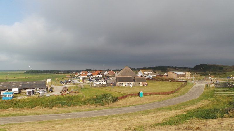
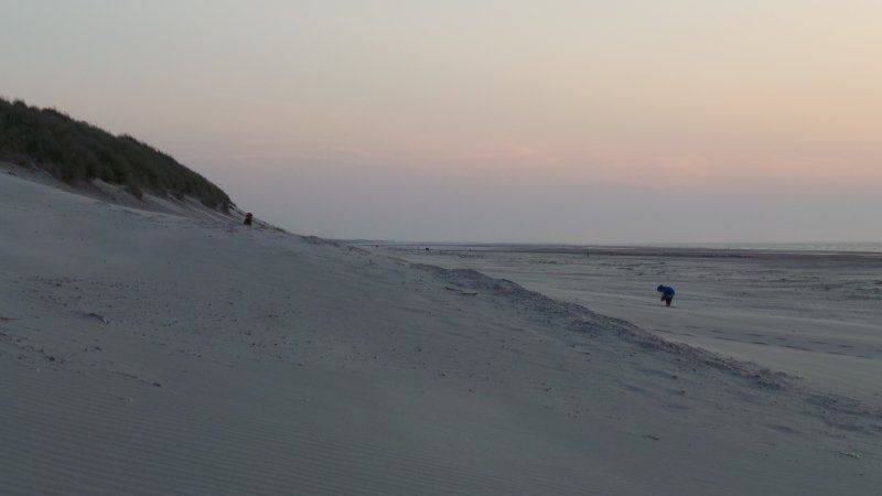
Camping Corfwater
Strandweg 3, 1755 LA, Petten, Niederlande
52° 46' 14.9" N 4° 39' 32" E
52.7708000 4.6589000
• Head northeast. Go for 279 m.
• Continue on Strandweg. Go for 74 m.
• Turn left onto Spreeuwendijk. Go for 868 m.
• Turn left onto Westerduinweg (N502) toward St. Maartenszee/Den Helder/Callantsoog. Go for 2.6 km.
• Take the 2nd exit from roundabout onto Westerduinweg (N502). Go for 3.5 km.
• Turn right onto Stolperweg (N503) toward Schagen/Den Helder. Go for 1.8 km.
• Take the 2nd exit from roundabout toward Schagerbrug/N248/Schagen/Den Helder/N9. Go for 426 m.
• Keep right toward Schagerbrug/Schagen/Hoorn/N248. Go for 27 m.
• Take the 2nd exit from roundabout onto Provincialeweg (N248) toward Schagerbrug/Schagen/Hoorn. Go for 438 m.
• Take the 3rd exit from roundabout onto Anna Paulownaweg (N249) toward Anna Paulowna/'t Zand/Leeuwarden. Go for 3.0 km.
• Pass 3 roundabouts and continue on Van Ewijcksvaart (N249). Go for 9.8 km.
• Take the 1st exit from roundabout onto Lelyweg (N99) toward Hippolytushoef/Leeuwarden/Amsterdam. Go for 4.6 km.
• Pass 4 roundabouts and continue on Rijksstraatweg (N99). Go for 7.7 km.
• Turn left and take ramp onto A7 (Afsluitdijk) toward Leeuwarden/Groningen. Go for 29.1 km.
• Take exit 15 toward Zurich/Harlingen/Leeuwarden/N31. Go for 639 m.
• Keep left onto A31 toward Harlingen/Leeuwarden/N31. Go for 1.5 km.
• Continue on N31. Go for 10.4 km.
• Keep left onto A31 toward Franeker. Go for 17.2 km.
• Take exit 22 toward Marsum/St. Annaparochie/Stiens. Go for 1.0 km.
• Continue on It Aldlân. Go for 19 m.
• Take the 3rd exit from roundabout onto Westergoawei (N383) toward A31/St. Annaparochie/Marssum/Harlingen. Go for 383 m.
• Take the 1st exit from Westergoawei roundabout onto Westergoawei (N383) toward Marssum/St. Annaparochie. Go for 181 m.
• Keep right toward Westergoawei/N383. Go for 28 m.
• Take the 2nd exit from roundabout onto Westergoawei (N383). Go for 2.2 km.
• Take the 1st exit from roundabout onto Middelseewei (N398). Go for 1.5 km.
• Pass 2 roundabouts and continue on Middelseewei (N398). Go for 4.9 km.
• Take the 3rd exit from roundabout onto Brédyk (N357). Go for 4.8 km.
• Pass 2 roundabouts and continue on Ljouwerterdyk (N357). Go for 11.2 km.
• Take the 3rd exit from roundabout onto Bjimsterweg (N356). Go for 3.1 km.
• Turn right onto Grândyk (N356). Go for 604 m.
• Take the Holwerd-Ameland Ferry. Stay on for 10.3 km.
• Head north on Reeweg. Go for 323 m.
• Turn right onto Reeweg. Go for 593 m.
• Take the 3rd exit from roundabout onto Achterdijken. Go for 1.0 km.
• Turn left onto Ballumerweg. Go for 439 m.
• Continue on Verbindingsweg. Go for 4.8 km.
• Take the 2nd exit from roundabout onto Verbindingsweg. Go for 1.7 km.
• Turn left onto P. Miedeweg. Go for 498 m.
• Turn right onto Trapweg. Go for 329 m.
• Arrive at Trapweg.
☍
144,0 km
(2 hrs. 29 min.)
Day
Day
Day
Day
Day
Day
Day
Day
Day
Ameland, Niederlande
53° 26' 26" N 5° 39' 31.6" E
53.4405640 5.6587659
• Head toward P. Miedeweg on Trapweg. Go for 329 m.
• Turn left onto P. Miedeweg. Go for 498 m.
• Turn right onto Verbindingsweg. Go for 1.6 km.
• Take the 2nd exit from roundabout onto Verbindingsweg. Go for 4.8 km.
• Continue on Ballumerweg. Go for 439 m.
• Turn right onto Achterdijken. Go for 955 m.
• Take the 1st exit from roundabout onto Reeweg. Go for 616 m.
• Turn left onto Reeweg. Go for 323 m.
• Take the Holwerd-Ameland Ferry. Stay on for 10.3 km.
• Head southeast on Grândyk (N356). Go for 604 m.
• Turn left onto Grândyk (N356). Go for 3.0 km.
• Take the 2nd exit from roundabout onto Hemmingawei (N356). Go for 8.1 km.
• Take the 1st exit from roundabout onto Rondweg-West (N356). Go for 632 m.
• Pass 2 roundabouts and continue on Rondweg-West (N356). Go for 1.2 km.
• Take the 3rd exit from roundabout onto Lauwersseewei (N361). Go for 1.3 km.
• Take the 1st exit from roundabout onto N361. Go for 597 m.
• Take the 1st exit from roundabout onto Sintrale as (N356) toward Broeksterwâld/Leeuwarden/Drachten. Go for 20.9 km.
• Keep right toward Drachten/Groningen/(A7). Go for 44 m.
• Take the 3rd exit from roundabout onto Waldwei (N31) toward Drachten/Groningen/(A7). Go for 9.4 km.
• Take ramp onto A7 toward Groningen. Go for 28.7 km.
• Continue on N7 (Weg Der Verenigde Naties). Go for 7.7 km.
• Take ramp onto A7 toward Oldenburg/Bad Nieuweschans/Hoogezand. Go for 46.6 km.
• Continue on A280. Go for 4.3 km.
• Take the left exit toward Emden/Leer/Oldenburg/Weener onto A31. Go for 20.7 km.
• Continue on A28 toward Bremen/Oldenburg/Leer-Ost. Go for 54.0 km.
• Take the exit toward Bremen/Osnabrück/Oldenburg-Haarentor/Oldenburg-Zentrum onto A28. Go for 42.4 km.
• Take the left exit toward Hamburg/Bremen onto A1. Go for 93.0 km.
• Take exit 43 toward Flensburg/Kiel/Hamburg-West/Tötensen/Flughafen onto A261 (Buchholzer Dreieck). Go for 10.3 km.
• Continue on A7. Go for 11.6 km.
• Keep right onto A7. Go for 7.9 km.
• Take exit 26 toward HH-Stellingen/A1/Elbbrücken/Centrum/Altona/Hagenbecks Tierpark/Stadion Arena onto B4/B5 (Kieler Straße). Go for 927 m.
• Turn left onto Kieler Straße. Go for 55 m.
• Turn right onto Kieler Straße. Go for 77 m.
• Arrive at Kieler Straße. Your destination is on the left.
☍
394,0 km
(4 hrs. 40 min.)
Day
Day
Day
Day
Day
Day
Day
Day
Day
Day
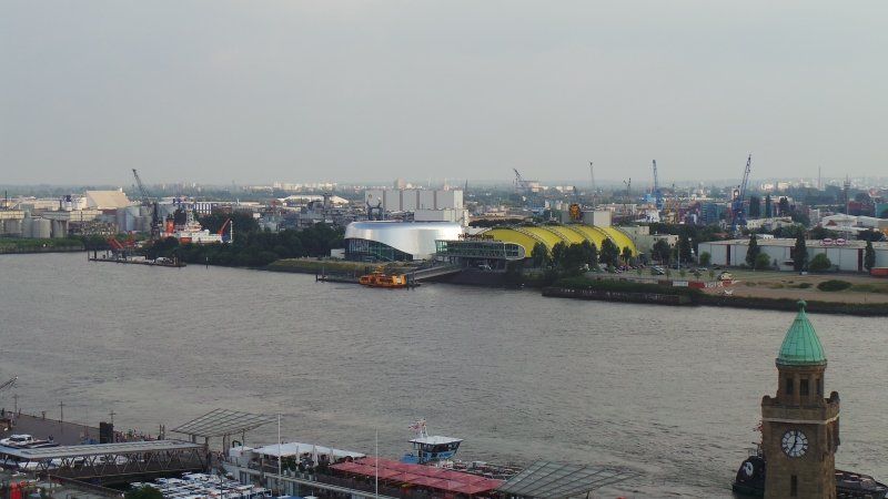
Camping Buchholz Hamburg City
Kieler Straße 374, 22525, Hamburg, Deutschland
53° 35' 24.4" N 9° 55' 53" E
53.5901000 9.9314000
• Head north on Kieler Straße. Go for 77 m.
• Turn left onto Kieler Straße. Go for 55 m.
• Turn left onto Kieler Straße (B4/B5). Go for 2.2 km.
• Turn left onto Eimsbütteler Marktplatz (B5) toward Centrum/City-Nord/Eppendorf/Messe/CCH. Go for 1.1 km.
• Continue on Fruchtallee. Go for 507 m.
• Continue on Schäferkampsallee. Go for 506 m.
• Continue on Schröderstiftstraße. Go for 588 m.
• Continue on An der Verbindungsbahn. Go for 318 m.
• Continue on Bundesstraße. Go for 157 m.
• Turn right onto Edmund-Siemers-Allee. Go for 379 m.
• Continue on Theodor-Heuss-Platz. Go for 194 m.
• Continue on Alsterglacis. Go for 205 m.
• Keep left onto Alsterglacis. Go for 94 m.
• Continue on Kennedybrücke. Go for 594 m.
• Take the 1st exit from roundabout onto An der Alster. Go for 998 m.
• Continue on Schwanenwik toward Elbbrücken/Krankenhaus Ak St. Georg. Go for 40 m.
• Turn right onto Sechslingspforte toward Elbbrücken/Krankenhaus Ak St. Georg. Go for 718 m.
• Continue on Wallstraße. Go for 376 m.
• Turn left onto Bürgerweide. Go for 855 m.
• Continue on Sievekingsallee toward Berlin/A24/Lübeck/Horn. Go for 2.1 km.
• Take the 2nd exit from Horner Kreisel roundabout onto A24 toward Berlin/Lübeck. Go for 5.9 km.
• Take the left exit toward Berlin/Schwerin onto A24. Go for 137 km.
• Take exit 17 toward Putlitz. Go for 377 m.
• Turn right onto Meyenburger Chaussee (L13) toward Meyenburg. Go for 6.9 km.
• Turn left onto Frehner Allee (K7021). Go for 167 m.
• Continue on K7021. Go for 557 m.
• Continue on Frehner Allee (K7021). Go for 1.6 km.
• Continue on K7021. Go for 165 m.
• Continue on Dorfring (K7021). Go for 155 m.
• Turn right onto Dorfring (L14). Go for 4.4 km.
• Turn left onto Plauer Straße (B103). Go for 6.9 km.
• Turn right onto Röbeler Straße (L17) toward Ganzlin. Go for 3.6 km.
• Turn right onto B198. Go for 6.3 km.
• Turn left onto Malchower Chaussee (L206) toward Malchow. Go for 7.9 km.
• Turn right onto Lexower Straße (K5) toward Roez/Walow. Go for 2.7 km.
• Continue on Zinnowitzer Straße (K5). Go for 1.8 km.
• Continue on Dorfstraße (K5). Go for 596 m.
• Turn left onto Kisserower Weg (K5). Go for 98 m.
• Continue on Roezer Weg (K5). Go for 387 m.
• Continue on K5. Go for 2.0 km.
• Continue on Malchower Straße (K5). Go for 90 m.
• Turn right onto Malchower Straße (B192) toward Neubrandenburg/Waren (Müritz). Go for 15.8 km.
• Turn left onto Teterower Straße toward Teterow/Gewerbegebiet Am Rothegrund/Schloss Ulrichshusen/B108. Go for 664 m.
• Take the 1st exit from roundabout onto Teterower Straße (B108) toward Teterow/Gewerbegebiet Rothegrund. Go for 558 m.
• Turn left onto Teterower Straße. Go for 200 m.
• Turn right onto Iesenbahnstraat. Go for 395 m.
• Turn left onto Iesenbahnstraat. Go for 158 m.
• Turn right onto Am Wiesengrund. Go for 38 m.
• Turn right onto Am Neuen Graben. Go for 363 m.
• Turn right onto Falkenhäger Weg. Go for 366 m.
• Turn left onto Falkenhäger Weg. Go for 31 m.
• Continue on Malchiner Straße. Go for 200 m.
• Turn right onto Lloydstraße. Go for 130 m.
• Turn left onto Bahnhofstraße. Go for 15 m.
• Arrive at Bahnhofstraße. Your destination is on the right.
☍
220,8 km
(2 hrs. 34 min.)
Day
Day
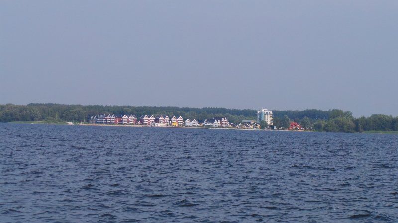
Waren (Müritz), Bahnhof, Waren (Müritz), Deutschland
17192 Waren (Müritz), Deutschland
53° 31' 17.4" N 12° 40' 51.9" E
53.5214914 12.6810709
• Head toward Wiesenstraße on Bahnhofstraße. Go for 57 m.
• Turn slightly right onto Lloydstraße. Go for 69 m.
• Turn left onto Malchiner Straße. Go for 200 m.
• Continue on Falkenhäger Weg. Go for 397 m.
• Turn left onto Am Neuen Graben. Go for 97 m.
• Turn right onto Buchenweg. Go for 94 m.
• Turn left onto Am Wiesengrund. Go for 225 m.
• Turn left onto Iesenbahnstraat. Go for 158 m.
• Turn right onto Iesenbahnstraat. Go for 395 m.
• Turn left onto Teterower Straße. Go for 200 m.
• Turn right onto B108. Go for 540 m.
• Take the 3rd exit from roundabout onto Teterower Straße toward A19/Neubrandenburg/Malchow/Zentrum/B192. Go for 692 m.
• Turn right onto Mozartstraße (B192) toward A19/Malchow/Röbel/Müritz/Gewerbegebiet Waren-West. Go for 12.8 km.
• Turn left onto Röbeler Straße (L24) toward Röbel/Müritz. Go for 7.4 km.
• Turn right onto Am Gildekamp (L24) toward A19/Plau am See/Neustrelitz. Go for 1.6 km.
• Turn left onto Bahnhofstraße (L241) toward Neustrelitz. Go for 685 m.
• Take the 1st exit from roundabout onto Mirower Straße (L241). Go for 5.5 km.
• Turn left onto B198. Go for 13.4 km.
• Turn left onto Jugendherberge. Go for 36 m.
• Turn right onto An der Clön. Go for 19 m.
• Arrive at An der Clön. Your destination is on the left.
☍
44,4 km
( 43 min.)
Day
Kanustation Mirow, An der Clön, Mirow, Deutschland
An der Clön 1, 17252 Mirow, Deutschland
53° 17' 21.4" N 12° 47' 38.6" E
53.2892854 12.7940570
• Head toward Jugendherberge on An der Clön. Go for 19 m.
• Turn left onto Jugendherberge. Go for 36 m.
• Turn right onto B198. Go for 13.4 km.
• Continue on B198 toward A19/Plau am See. Go for 12.2 km.
• Take the 1st exit from roundabout onto Plauer Chaussee (B198) toward Berlin/Hamburg/A19/Pritzwalk/Plau am See. Go for 278 m.
• Take the 2nd exit from roundabout onto A19 toward Berlin/Hamburg. Go for 27.2 km.
• Continue on A24. Go for 62.6 km.
• Take exit 26 toward Leipzig/Magdeburg/Potsdam onto A10 (Autobahndreieck Havelland). Go for 47.1 km.
• Take exit 21 toward Hannover/Magdeburg onto A2 (Autobahndreieck Werder). Go for 154 km.
• Take exit 58 toward Kassel/Salzgitter/Braunschweig-Süd onto A39. Go for 50.9 km.
• Take the left exit toward Kassel onto A7. Go for 115 km.
• Take exit 79 toward Marburg/Kassel onto A49 (Südtangente). Go for 86.5 km.
• Take the left exit toward Basel/Frankfurt/Wiesbaden/Gießen onto A5. Go for 107 km.
• Take exit 25 toward Darmstadt-Nord onto B42. Go for 3.3 km.
• Continue on Carl-Schenck-Ring toward Messel/DA-Kranichstein/Merck-Stadion. Go for 1.4 km.
• Turn right onto Frankfurter Straße toward Heidelberg/Stadtmitte/Merck-Stadion. Go for 1.6 km.
• Continue on Mathildenplatz. Go for 219 m.
• Continue on Cityring. Go for 142 m.
• Arrive at Cityring. Your destination is on the left.
☍
682,4 km
(6 hrs. 3 min.)
Day
Day
Day
Day
Day
Darmstadt, Deutschland
49° 52' 22.2" N 8° 39' 4.3" E
49.8728253 8.6511929