Day
Basingstoke, UK
Friday 13th May and finally its 12 noon and the start of our trip around Ireland. Been planning our trip for month’, the places to see, the things to take in and highlights not to miss. Advice taken from all over, including YouTube and previous trips blogged on various platforms.
51° 15' 59.5" N 1° 5' 32.6" W
51.2665400 -1.0923964
• Follow the roundabout. Go for 155 m.
• Take the 3rd exit from roundabout onto Churchill Way West (A3010). Go for 1.0 km.
• Take the 3rd exit from Thornycroft Roundabout roundabout onto Ringway West (A340) toward (M3)/Reading/(A33)/Newbury/(A339)/Aldermaston/Daneshill/Chineham/Houndmills. Go for 1.2 km.
• Take the 1st exit from roundabout onto A339 toward Newbury/Winklebury/Kingsclere/Headley. Go for 952 m.
• Pass 5 roundabouts and continue on A339. Go for 19.3 km.
• Take the 2nd exit from roundabout onto Newtown Road (A339) toward Newbury. Go for 1.3 km.
• Pass 2 roundabouts and continue on Greenham Road (A339). Go for 1.8 km.
• Take the 1st exit from roundabout onto A339 toward (M4)/Oxford/(A34)/Hungerford/(A4)/Thatcham. Go for 881 m.
• Keep right onto A339 toward (M4)/Oxford/(A34). Go for 1.1 km.
• Take the 2nd exit from roundabout onto A339. Go for 1.6 km.
• Take ramp onto A34. Go for 1.6 km.
• Keep right onto A34 toward The Midlands/Oxford. Go for 54.3 km.
• Take the 1st exit from Wendlebury Interchange roundabout toward The Midlands/Northampton/Banbury. Go for 68 m.
• Take ramp onto M40. Go for 73.6 km.
• Continue on M42. Go for 17.0 km.
• Take exit 4A toward The North West/M5(N)/B'Ham (W,N & Cent)/Stourbridge/(M6) onto M5. Go for 27.7 km.
• Continue on M6. Go for 13.7 km.
• Keep right onto M6. Go for 89.9 km.
• Take exit 20 toward N Wales/Chester/Runcorn onto M56. Go for 28.4 km.
• Take exit 15 toward Ellesmere Port/Birkenhead onto M53. Go for 16.4 km.
• Take exit 4 toward Clatterbridge/Heswall/Bebington. Go for 387 m.
• Take the 4th exit from roundabout onto Mount Road (B5151) toward Birkenhead/Higher Bebington/Tranmere Rovers F.C. Go for 3.1 km.
• Take the 2nd exit from roundabout onto Mount Road (B5151). Go for 43 m.
• Take the 2nd exit from roundabout onto Thornton Road. Go for 594 m.
• Turn left onto Borough Road. Go for 2.4 km.
• Arrive at Borough Road (A552). Your destination is on the left.
☍
358,6 km
(3 hrs. 31 min.)
Birkenhead, UK
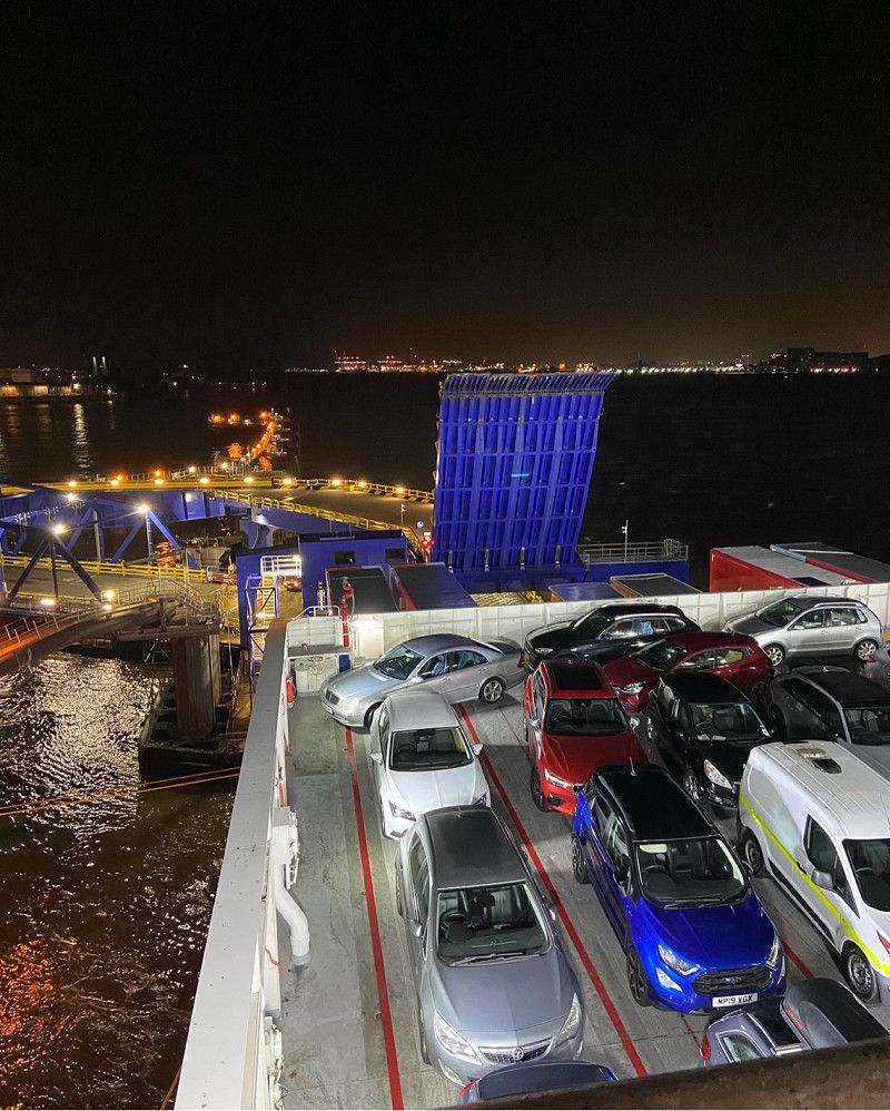
22:00 Stena line ferry to Belfast
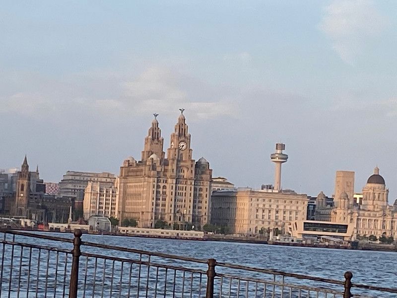
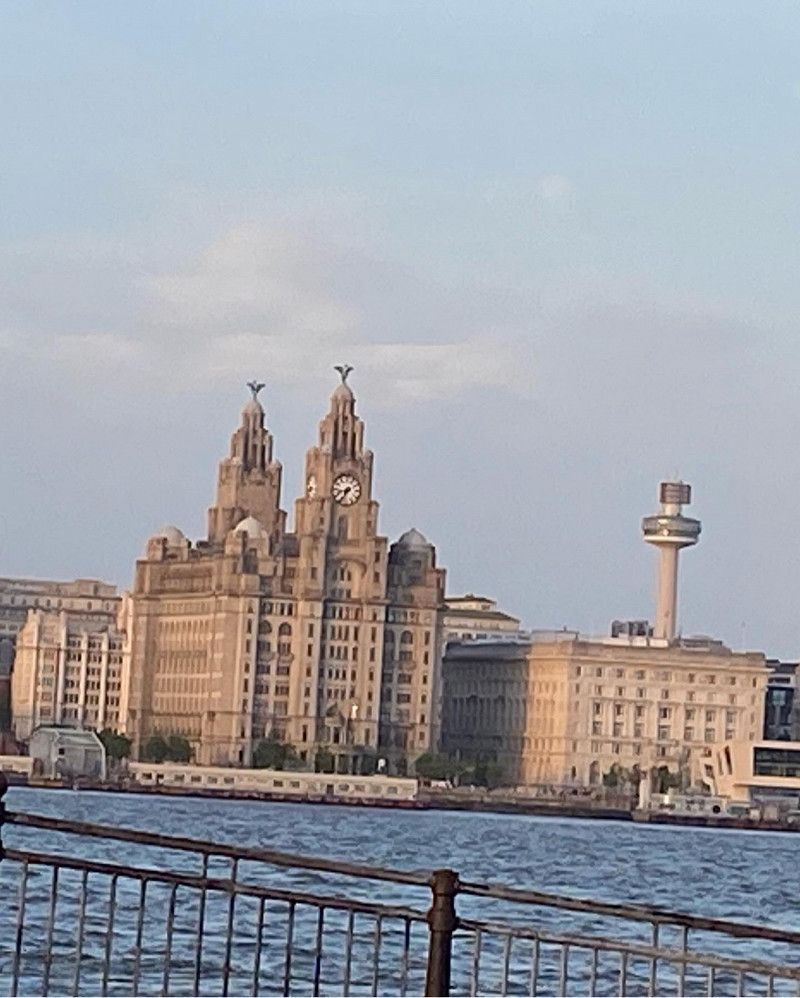
Took nearly 6 hours to get to Birkenhead from Basingstoke. Traffic around Birmingham was awful as a Friday and rush hour, comfort breaks and a fuel also took their tolls on the journey time. Parked at the port ready for check in and boarding. Looked a full boat
53° 23' 17.2" N 3° 1' 47.7" W
53.3881164 -3.0299176
• Head northeast on Borough Road (A552). Go for 365 m.
• Take right ramp onto Queensway Tunnel (A41). Go for 4.1 km.
• Continue on Queensway Entrance (A41). Go for 100 m.
• Take the 1st exit from roundabout onto Byrom Street (A59). Go for 174 m.
• Keep left onto Byrom Street (A59) toward (M6)(N)/(M58)/St Helens/(A580)/Widnes/(A561)/Southport/Bootle/(A567)/Liverpool Airport/Wallasey. Go for 1.5 km.
• Keep right onto Scotland Road (A59) toward The Walton Centre. Go for 718 m.
• Keep left onto Walton Road (A59) toward Walton/Kirkdale. Go for 379 m.
• Turn left onto Walton Road (A59). Go for 1.8 km.
• Take the 2nd exit from roundabout onto Rice Lane (A59) toward (M57)/(M58)/Fazakerley/(A506)/Aintree/Walton/University Hospital Aintree. Go for 2.0 km.
• Keep left onto Warbreck Moor (A59) toward (M57)/Preston/(M58)/Southport/Aintree. Go for 3.3 km.
• Keep right toward Preston/(M6)/Skelmersdale/Ormskirk. Go for 43 m.
• Turn right onto A59 toward Preston/(M6)/Skelmersdale/Ormskirk. Go for 62 m.
• Keep left onto A59 toward Preston/(M6)/Skelmersdale/Ormskirk. Go for 470 m.
• Keep right onto M58 toward Skelmersdale/Preston/(M6). Go for 11.9 km.
• Take exit 4 toward Skelmersdale. Go for 307 m.
• Take the 1st exit from roundabout onto Glenburn Road (A5068) toward Skelmersdale/Gillibrands. Go for 582 m.
• Take the 3rd exit from roundabout onto Grimshaw Road (B5312) toward Ring Road (E)/Up Holland/Town Centre. Go for 889 m.
• Take the 1st exit from roundabout onto Grimshaw Road (B5312) toward Up Holland/(A577)/Digmoor/Tanhouse/Beacon Country Park. Go for 1.8 km.
• Take the 2nd exit from roundabout onto Windmill Road (A577). Go for 370 m.
• Take the 2nd exit from roundabout onto Newgate Road (A577). Go for 373 m.
• Take the 1st exit from roundabout onto Ormskirk Road (A577). Go for 551 m.
• Pass 4 roundabouts and continue on Dingle Road (A577). Go for 1.1 km.
• Take the 2nd exit from roundabout onto Grove Road (A577). Go for 2.5 km.
• Turn right onto M58 toward Liverpool/Southport/Skelmersdale/Birmingham/Preston/(M6). Go for 411 m.
• Take the 2nd exit from roundabout onto M58 toward Preston/M6/Liverpool/Southport/Skelmersdale. Go for 589 m.
• Take the 1st exit from roundabout onto M6 toward Preston. Go for 183 km.
• Continue on A74(M). Go for 946 m.
• Take exit 22 toward South West Scotland/Dumfries/Stranraer/Gretna/(B7076). Go for 562 m.
• Keep right onto A75 toward South West Scotland/Dumfries/Stranraer. Go for 34.1 km.
• Take the 2nd exit from roundabout onto A75 toward Dumfries Bypass. Go for 1.5 km.
• Pass 2 roundabouts and continue on A75. Go for 4.2 km.
• Take the 4th exit from roundabout onto A75 toward Stranraer. Go for 2.1 km.
• Take the 2nd exit from roundabout onto A75 toward Stranraer. Go for 683 m.
• Take the 3rd exit from Garroch Roundabout roundabout onto A75 toward Stranraer. Go for 4.3 km.
• Take the 2nd exit from Drumore Roundabout roundabout onto A75 toward Stranraer. Go for 18.5 km.
• Take the 2nd exit from roundabout onto A75 toward Stranraer/Ayr/(A713). Go for 4.0 km.
• Take the 2nd exit from roundabout onto A75 toward Stranraer. Go for 46.3 km.
• Take the 2nd exit from roundabout onto A75 toward Stranraer/Girvan/(A714). Go for 35.5 km.
• Turn right onto A751 toward Cairnryan/Ayr/(A77). Go for 2.8 km.
• Turn right onto A77 toward Cairnryan/Ayr. Go for 4.4 km.
• Turn left toward P & O Larne Ferry. Go for 35 m.
• Take the 1st exit from roundabout. Go for 224 m.
• Turn left. Go for 903 m.
• Take the Cairnryan-Larne Ferry. Stay on for 61.6 km.
• Head southwest. Go for 154 m.
• Turn left. Go for 91 m.
• Take the 3rd exit from roundabout. Go for 116 m.
• Take the 3rd exit from Larne Harbour Roundabout roundabout onto The Harbour Highway (A8) toward Belfast/Londonderry/Ballymena/(A36)/Coleraine/Carrickfergus/(A2)/Town Centre. Go for 628 m.
• Take the 1st exit from Redlands Roundabout roundabout onto Belfast Road (A8) toward Belfast/Londonderry/Ballymena/(A36)/Carrickfergus/(A2)/Town Centre. Go for 2.2 km.
• Keep left onto Belfast Road (A8) toward Belfast/Londonderry/Ballymena/(A36). Go for 1.7 km.
• Take the 2nd exit from Millbrook Roundabout roundabout onto Belfast Road (A8) toward Belfast/Londonderry/(M2)/Ballymena/(A36). Go for 1.1 km.
• Pass 3 roundabouts and continue on Ballynure Road (A8). Go for 18.2 km.
• Take the 3rd exit from roundabout onto A8(M) toward Belfast/(M2). Go for 1.6 km.
• Take the 3rd exit from Sandyknowes Roundabout roundabout onto M2 toward Belfast. Go for 9.9 km.
• Take exit 1A toward Belfast (W)/M2/The West/The South/(A12)/(M1) onto A2 (Nelson Street). Go for 430 m.
• Continue on Great Georges Street (A12). Go for 87 m.
• Keep middle onto Westlink (A12) toward The West/The South/(M1). Go for 1.2 km.
• Take ramp onto Divis Street (A501) toward City Centre. Go for 463 m.
• Turn right onto College Avenue (B126). Go for 300 m.
• Turn left onto Wellington Place (A1) toward City Centre. Go for 296 m.
• Arrive at Donegall Square North (A1).
☍
479,7 km
(6 hrs. 39 min.)
Day
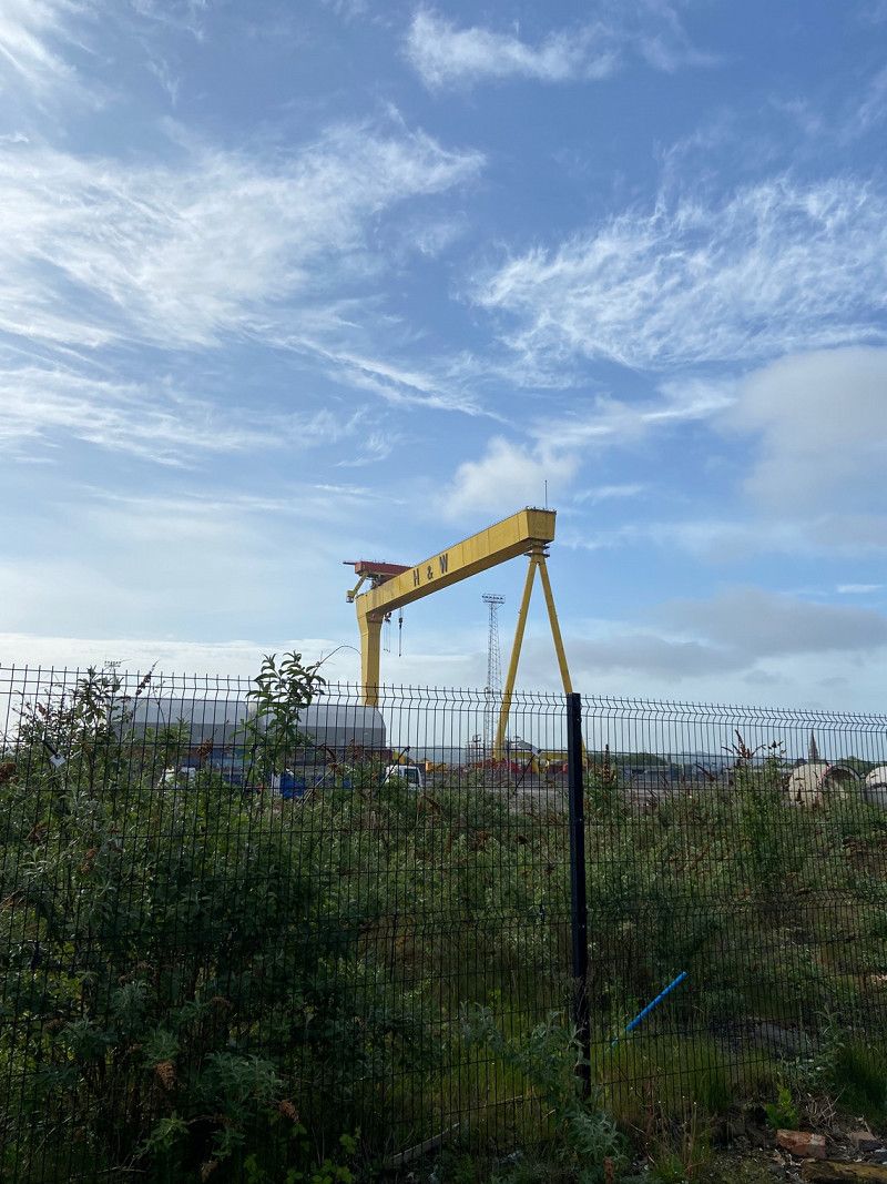
Belfast, UK
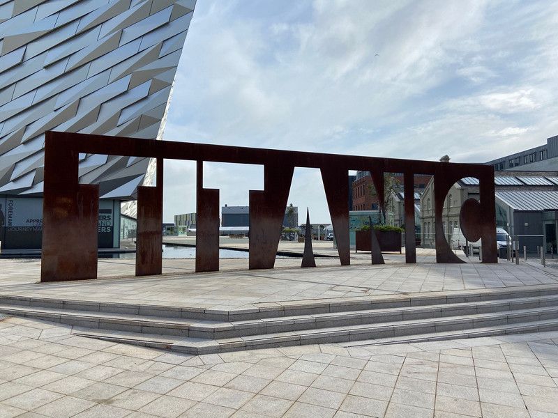
Alarm went off at 5am, bleary eyed we looked out the large round window to see the port of Belfast starting to appear in our view. We had already decided to skip breakfast on the ship and take it in the van once we had disembarked and parked up. Titanic experience today so we headed for the car park across the road which allows Motorhomes.
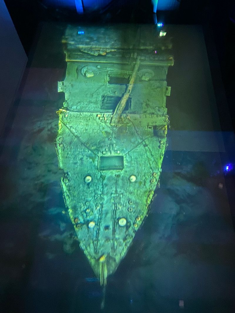
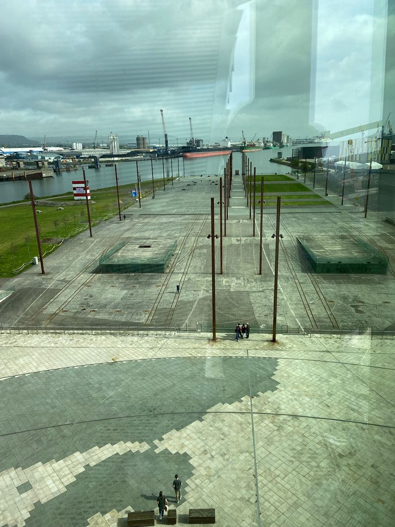
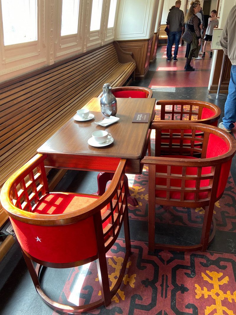
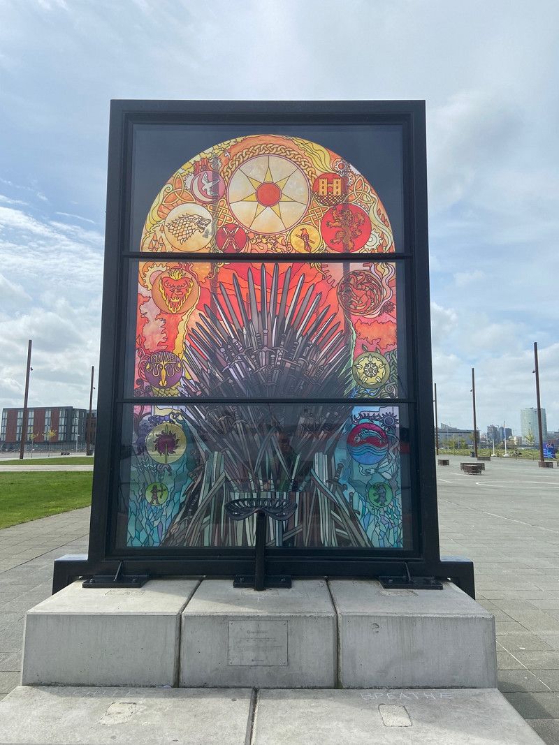
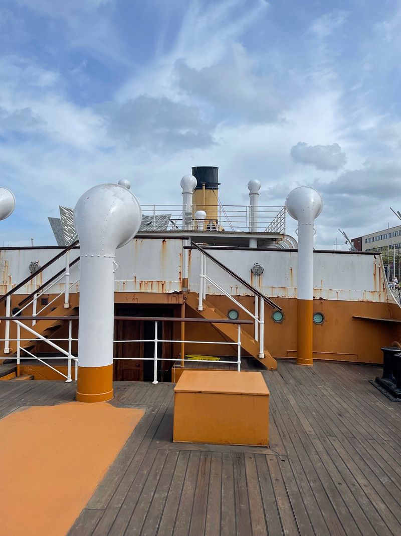
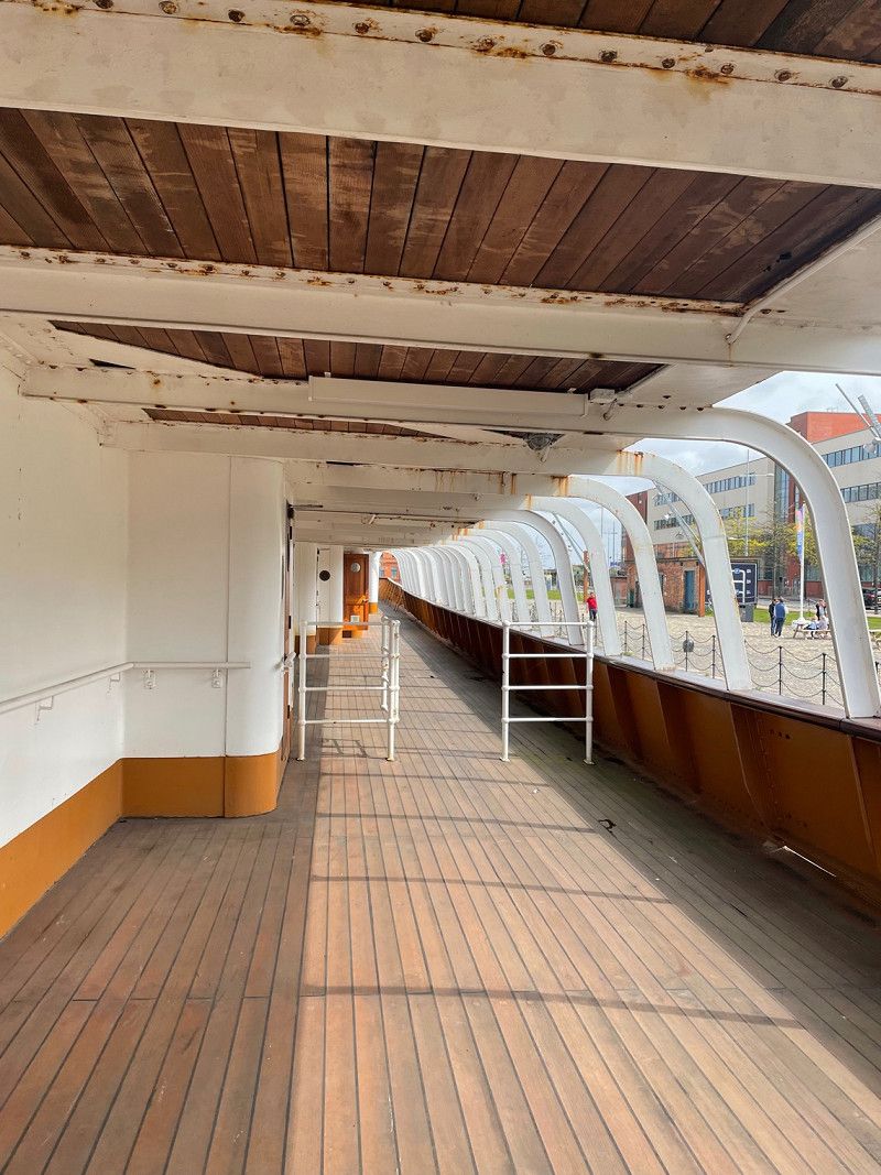
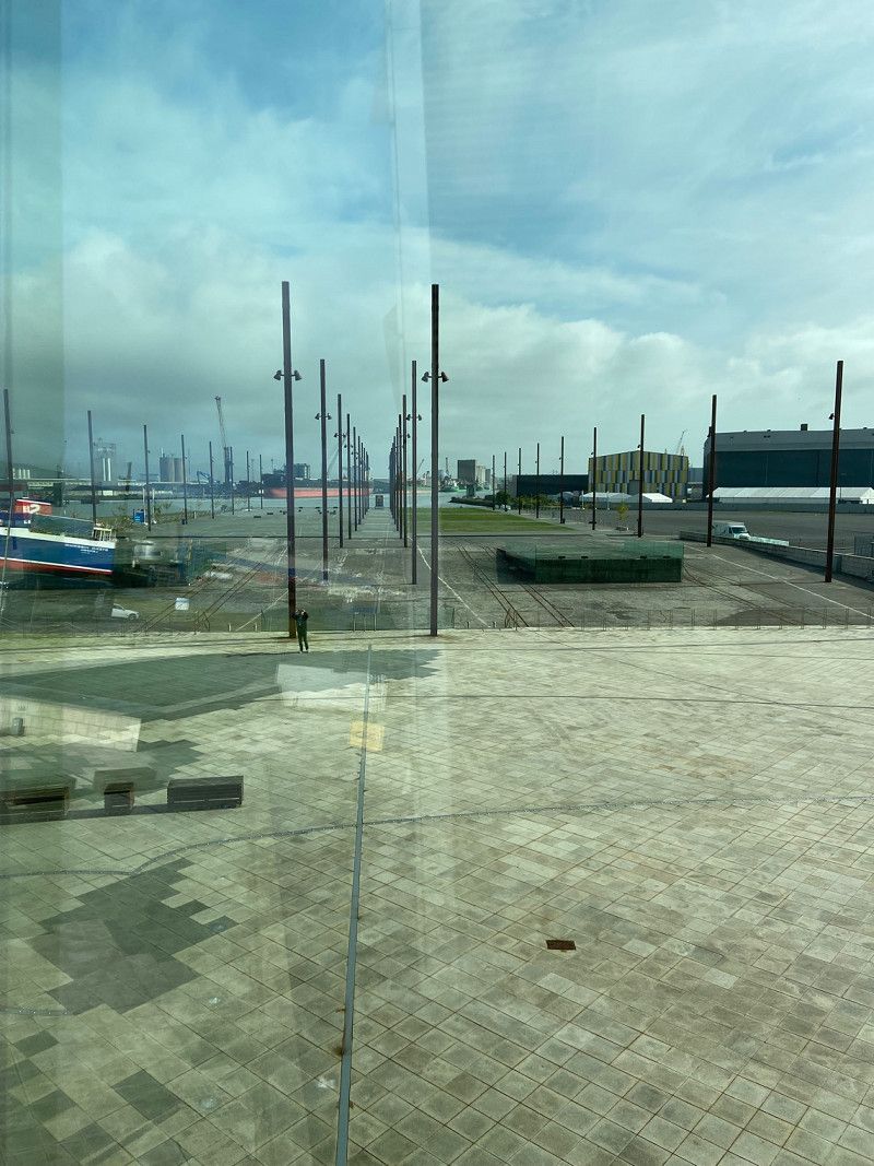
The tour is very informative and well worth the entrance fee. Headsets are provided and talks you through the history of the dockyard and the build of the liner. You also get the entrance to the SS Nomadic, a tender to the Titanic which is still as it was back in 1912.
54° 35' 50.2" N 5° 55' 48.4" W
54.5972850 -5.9301200
• Head toward Callender Street on Donegall Square North (A1). Go for 405 m.
• Turn left onto Victoria Street (A24) toward Bangor/(A2)/(A6)/(M2). Go for 444 m.
• Keep left onto Victoria Street (A2) toward The NORTH/(M2)/International Airport/Dublin/(M1)/(A12). Go for 481 m.
• Turn right onto York Street (A2) toward The NORTH/Larne/Carrickfergus/Yorkgate Station/Docks. Go for 280 m.
• Keep right onto A12 toward The North/Larne/International Airport/Stena Line. Go for 111 m.
• Take ramp onto M2 toward The North/Larne/International Airport/Stena Line. Go for 28.2 km.
• Take exit 1 toward Coleraine/Ballymena. Go for 461 m.
• Take the 3rd exit from roundabout onto Lisnevenagh Road (A26) toward Ballymena/Coleraine. Go for 11.4 km.
• Take the 3rd exit from Ballee Roundabout roundabout onto A26 toward (M2)/Coleraine/Ballymena/Larne/(A36)/Ecos Centre. Go for 1.6 km.
• Keep right onto M2 toward Coleraine/(A26)/Ecos Centre. Go for 7.8 km.
• Continue on A26. Go for 339 m.
• Continue on Crankill Road (A26) toward Coleraine/Ballycastle/A44. Go for 13.4 km.
• Take the 2nd exit from Drones Road Roundabout roundabout onto Drones Road (A44) toward Ballycastle/Armoy/Rathlin Island/Loughguile. Go for 13.3 km.
• Turn left toward Church Road. Go for 95 m.
• Turn left onto Gracehill Road (B15). Go for 2.4 km.
• Turn right onto Bregagh Road. Go for 1.5 km.
• Arrive at Bregagh Road.
☍
82,2 km
( 55 min.)
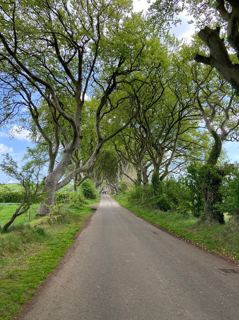
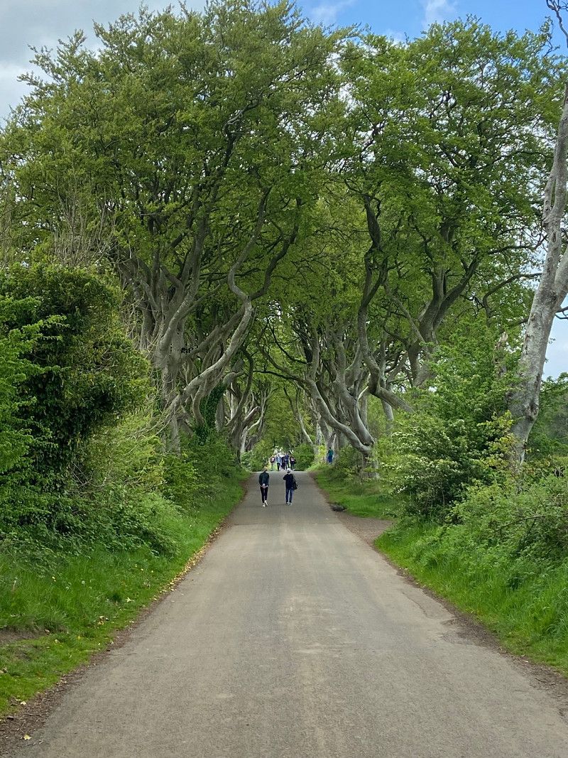
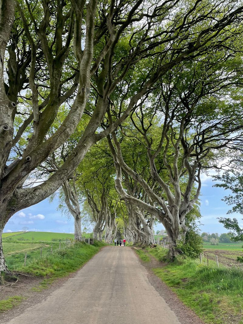
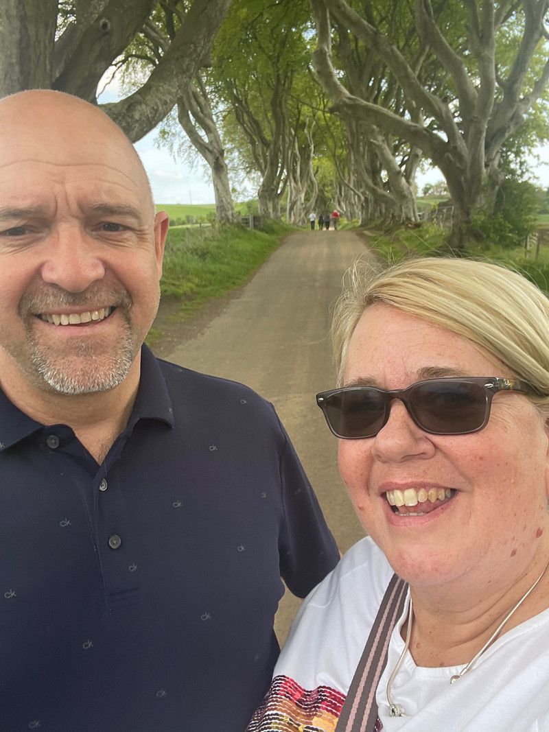
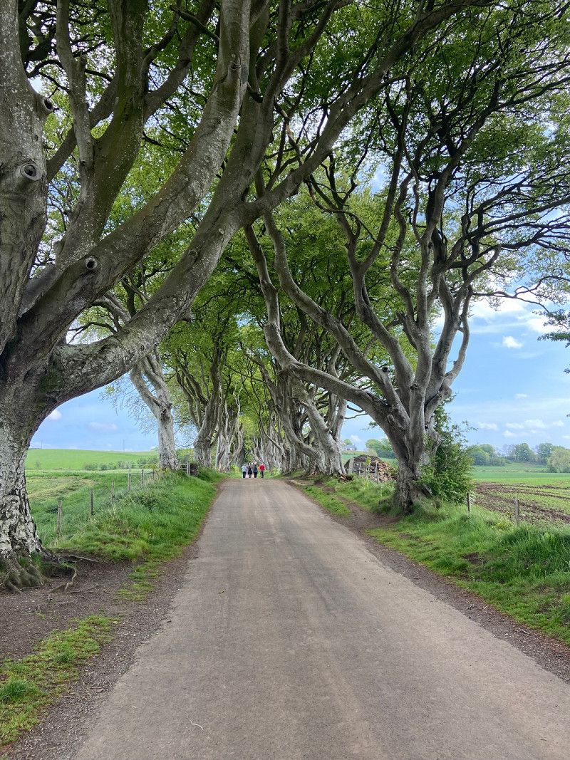
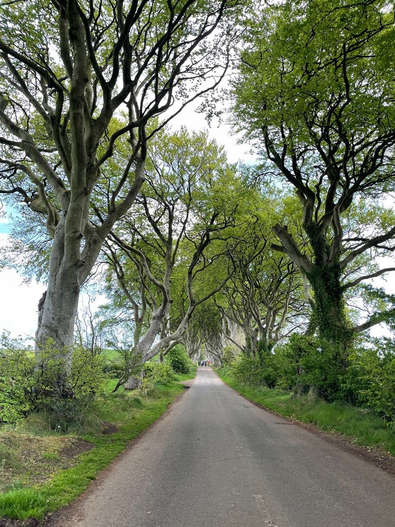
The Dark Hedges, Bregagh Road, Stranocum, Ballymoney, UK
A busy morning turned and onto the afternoon, A visit to the Dark Hedges Road from a Game of Thrones. Large car park only 10 minute walk from the road, the walk is flat but the path is not paved so a bit uneven in places. Worth the detour on our drive north to the coast.
Bregagh Rd, Stranocum, Ballymoney BT53 8PX, UK
55° 8' 4.9" N 6° 22' 51" W
55.1346929 -6.3808220
• Head toward Ballykenver Road on Bregagh Road. Go for 217 m.
• Turn left onto Ballykenver Road. Go for 317 m.
• Turn left toward Chatham Road. Go for 645 m.
• Turn left onto Chatham Road. Go for 561 m.
• Turn right onto Ballinlea Road (B147). Go for 2.4 km.
• Turn right toward Moyarget Road/B67. Go for 79 m.
• Continue on Moyarget Road (B67). Go for 7.7 km.
• Turn left onto Whitepark Road. Go for 352 m.
• Turn right onto Straid Road (A2). Go for 44 m.
• Turn left onto Whitepark Road. Go for 1.5 km.
• Turn right onto Clare Road (B15). Go for 1.6 km.
• Turn left. Go for 27 m.
• Turn right. Go for 96 m.
• Arrive at your destination on the right.
☍
15,5 km
( 16 min.)
Causeway Coast Holiday Park
Booked in for one night, grass pitch and not very level. Staff were very friendly and welcoming, facilities could do with updating but were clean.
21 Clare Road,, BT54 6DB, Ballycastle, United Kingdom
55° 12' 32.8" N 6° 14' 50.6" W
55.2091200 -6.2474000
• Head east.
• Turn slightly left. Go for 83 m.
• Turn left. Go for 16 m.
• Turn left. Go for 64 m.
• Take the 1st exit from roundabout. Go for 141 m.
• Turn right onto Clare Road (B15). Go for 1.6 km.
• Turn right onto Whitepark Road (B15). Go for 3.6 km.
• Keep left onto B15. Go for 576 m.
• Continue on Whitepark Road (B15). Go for 2.6 km.
• Continue on B15. Go for 194 m.
• Continue on Main Street (B15). Go for 680 m.
• Continue on B15. Go for 22 m.
• Continue on Whitepark Road (B15). Go for 10.0 km.
• Turn right onto Causeway Road (B146). Go for 854 m.
• Turn left onto Runkerry Road. Go for 360 m.
• Turn slightly left onto Runkerry Road. Go for 849 m.
• Arrive at Runkerry Road.
☍
21,7 km
( 23 min.)
Day
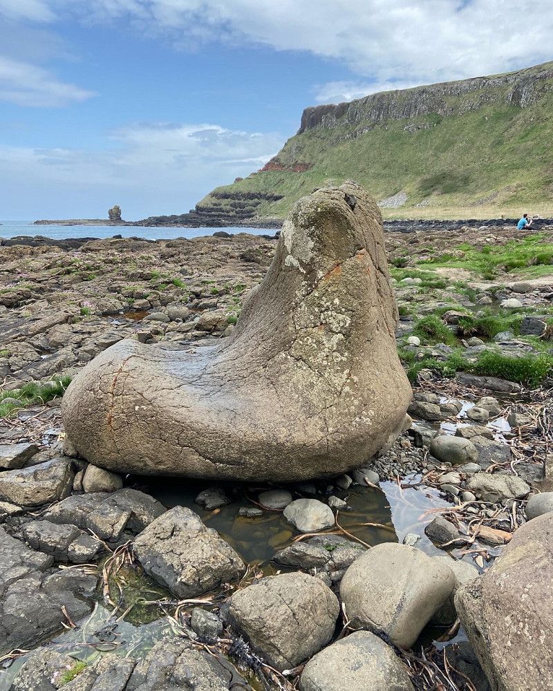
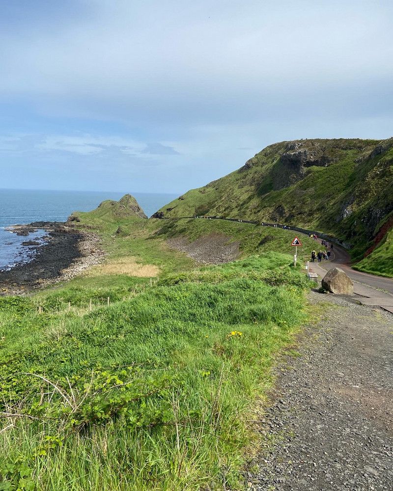
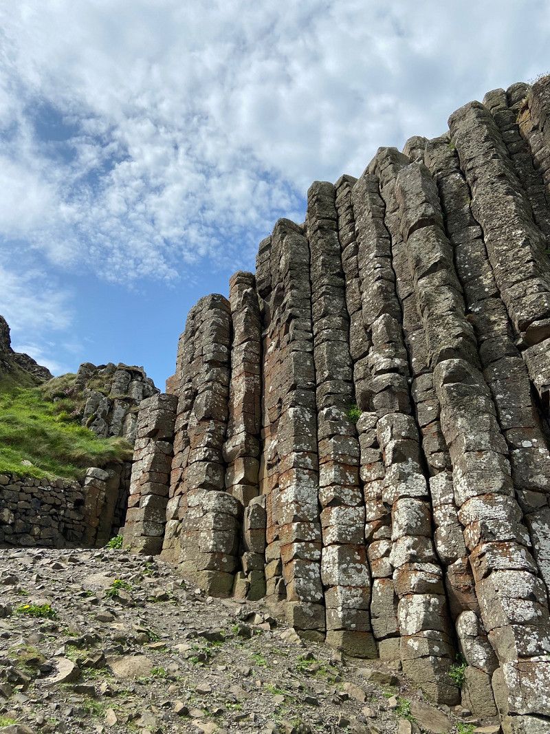
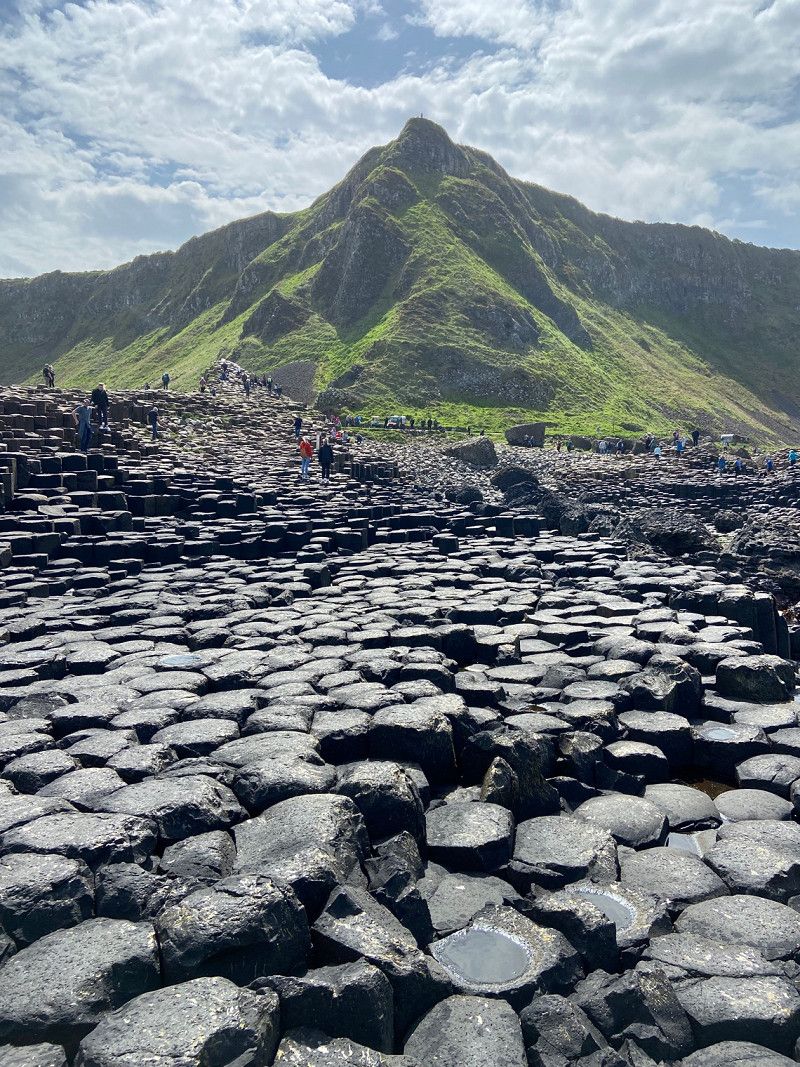
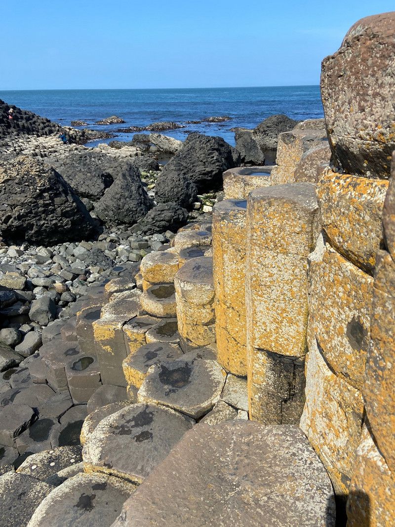
Giants Causeway, Bushmills, UK
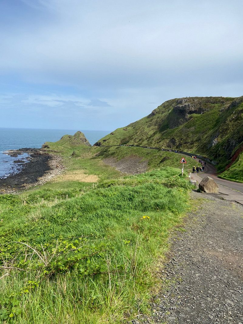
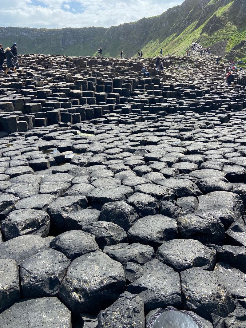
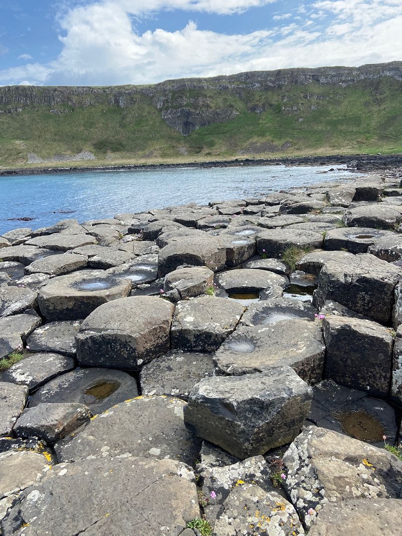
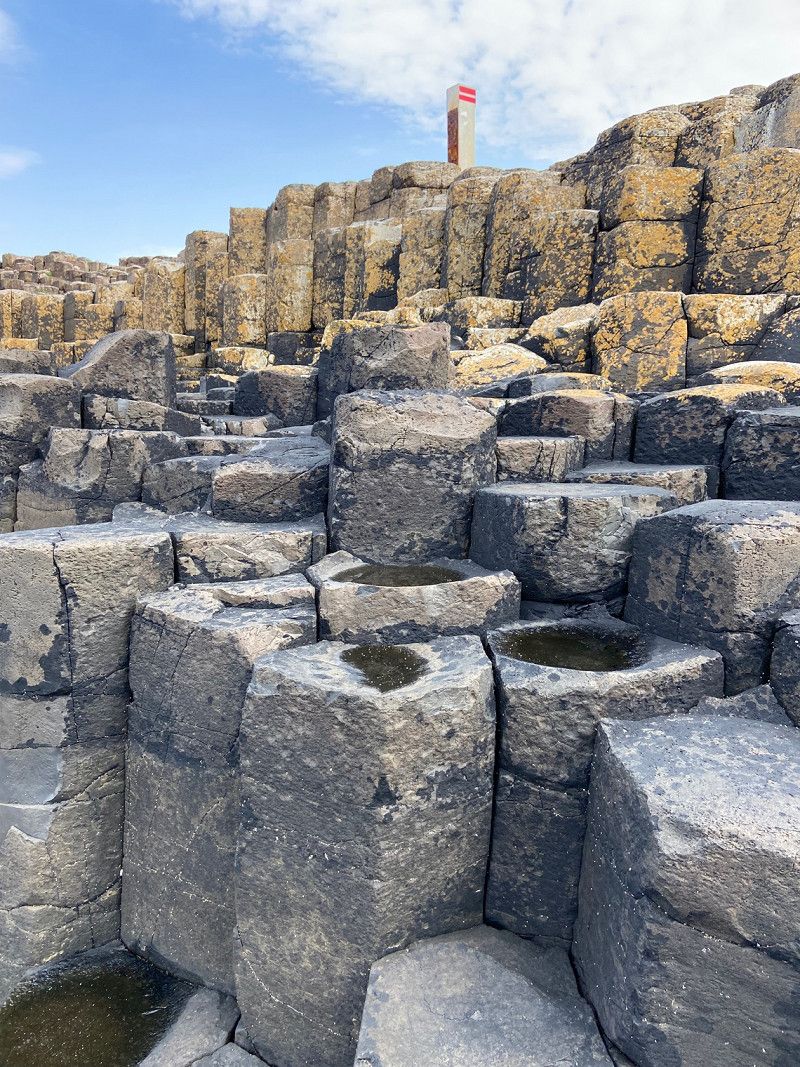
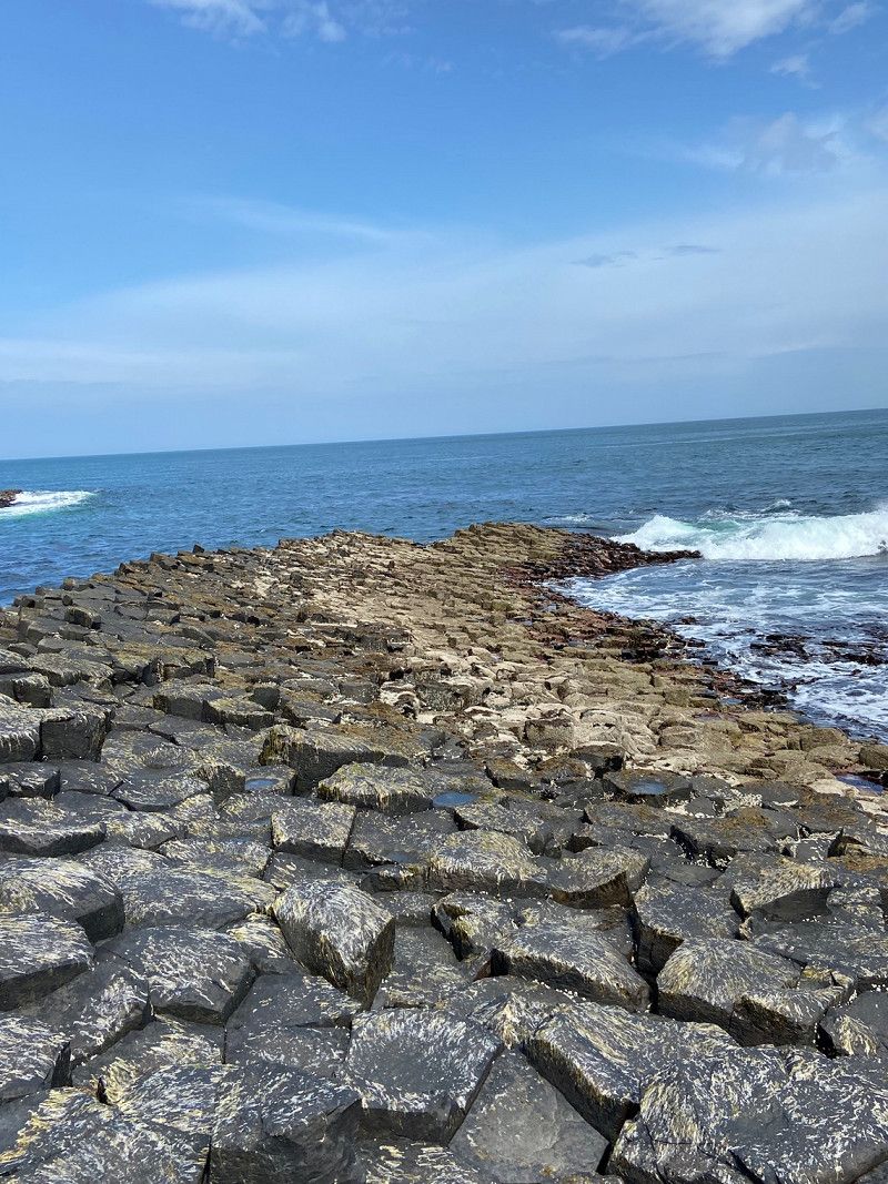
We leave the campsite and travel the 15 or so miles to the Causeway, an easy drive that only took about 30 minutes. We. Had planned on visiting Ballintoy Harbour, but a sign said No Motorhomes so we decided against it. If it was a weekday i would have attempted in but you never know with the weekends. Next time. For sure. Causeway car park was busy but we had booked tickets so straight in for us. I would recommend booking to avoid being turned away if busy. We parked right on the end of a row so we didn’t stick out to far.
Inside the entrance there is an interactive area with films and finds etc.. They explain the myths around the two giants fighting but i wont give it away. Good for both adults and children with a variety of things to do. We decide to walk down and get the shuttle bus back up, path is a little step in places but tarmac so sure under foot. The place is busy as you would expect but enough space not to feel cramped or rushed as you walk around. Good footwear essential on the stones, they are a little uneven as you would imagine.
Giants Causeway, Bushmills BT57 8SZ, UK
55° 13' 56" N 6° 31' 45" W
55.2322222 -6.5291667
• Head east on Runkerry Road. Go for 1.2 km.
• Continue on Causeway Road (B146). Go for 854 m.
• Turn right onto Whitepark Road (A2). Go for 1.8 km.
• Take the 2nd exit from roundabout onto Dunluce Road (A2). Go for 290 m.
• Turn left onto Priestland Road (B17). Go for 5.2 km.
• Turn right onto Ballybogy Road (B62). Go for 72 m.
• Turn left onto Cloyfin Road (B17). Go for 5.6 km.
• Take the 1st exit from Bushmills Road Roundabout roundabout onto Ring Road (A29). Go for 1.3 km.
• Take the 2nd exit from Ballycastle Road Roundabout roundabout onto Ring Road (A29). Go for 1.4 km.
• Take the 3rd exit from Lodge Road Roundabout roundabout onto Ring Road (A29) toward Cookstown/Garvagh/Londonderry/Limavady/(A37)/Kilrea/(A54)/Castlerock/(B201)/Killowen/Waterside. Go for 1.2 km.
• Pass 4 roundabouts and continue on Broad Road (A37). Go for 20.5 km.
• Take the 1st exit from Killane Roundabout roundabout onto Ballykelly Road (A2) toward Londonderry/Airport/Limavady. Go for 1.6 km.
• Take the 2nd exit from Lisnakilly Roundabout roundabout onto Ballykelly Road (A2) toward Londonderry/Eglinton/Airport/Ballykelly. Go for 10.7 km.
• Turn left onto Killylane Road. Go for 3.0 km.
• Continue on Moulton Park. Go for 290 m.
• Continue on Main Street (B118). Go for 584 m.
• Turn right. Go for 44 m.
• Arrive at your destination on the right.
☍
55,6 km
( 53 min.)
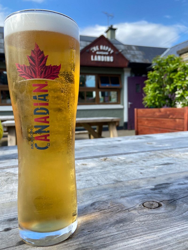
The Happy Landing, Main Street, Eglinton, Londonderry, UK
Pub stopover for the night. Quiet car park with easy access. Great food and very friendly staff. Would recommend if passing through.
4 Main Street, Eglinton, Londonderry BT47 3PQ, UK
55° 1' 36.9" N 7° 10' 47.9" W
55.0269190 -7.1799780
• Head southeast. Go for 44 m.
• Turn left onto Main Street (B118). Go for 139 m.
• Turn left onto Coolafinny Road (B118). Go for 934 m.
• Take the 1st exit from Broadbridge Roundabout roundabout onto Clooney Road (A2) toward Londonderry. Go for 1.8 km.
• Pass 3 roundabouts and continue on Clooney Road (A2). Go for 4.9 km.
• Take the 4th exit from Caw Roundabout roundabout onto Madams Bank Road (A515) toward Letterkenny/Buncrana/(A2)/Moville. Go for 2.5 km.
• Take the 3rd exit from Culmore Road Roundabout roundabout onto Culmore Road (A2). Go for 5.5 km.
• Continue on Main Street (R238). Go for 21.2 km.
• Continue on Main Street (R241). Go for 909 m.
• Continue on Carnagarve (R241). Go for 1.1 km.
• Continue on Ballybrack (R241). Go for 167 m.
• Turn left onto Ballybrack. Go for 512 m.
• Continue on Drumaweer. Go for 1.2 km.
• Continue on Shilling Hill. Go for 327 m.
• Continue on Eleven Ballyboes. Go for 323 m.
• Continue on Balleeghan. Go for 368 m.
• Continue on Eleven Ballyboes. Go for 421 m.
• Continue on Balleeghan. Go for 133 m.
• Continue on Eleven Ballyboes. Go for 343 m.
• Continue on Carrowhugh. Go for 302 m.
• Continue on The Warren. Go for 34 m.
• Continue on Carrowhugh. Go for 564 m.
• Continue on Carrowtrasna. Go for 1.2 km.
• Continue on Stroove. Go for 593 m.
• Turn left onto Head Road. Go for 692 m.
• Arrive at Head Road.
☍
46,3 km
( 43 min.)
Day
Inishowen Head, Ireland
We leave the pub after a peaceful sleep, we start the Wild Atlantic Way for real this morning. Travel to the start at Muff and then onto Inishowen Head for a picture of one of the viewpoint signs. Very blustery and not surprised when were the only ones there, a walk on the beach and time for us to have a walk. Joined 30 mins later by two men who have arrived for a cold swim, rather them than me that water was bloody freezing. Had a chat for a while and explained our route, they seemed envious. We watched them walk into the icy water and we headed for the van and a hot drink. Now onto Londonderry for a walk around the city.
55° 13' 60" N 6° 55' 0" W
55.2333333 -6.9166667
• Head toward Stroove on Head Road. Go for 692 m.
• Turn right onto Stroove. Go for 593 m.
• Continue on Carrowtrasna. Go for 1.2 km.
• Continue on Carrowhugh. Go for 564 m.
• Continue on The Warren. Go for 34 m.
• Continue on Carrowhugh. Go for 302 m.
• Continue on Eleven Ballyboes. Go for 343 m.
• Continue on Balleeghan. Go for 133 m.
• Continue on Eleven Ballyboes. Go for 421 m.
• Continue on Balleeghan. Go for 368 m.
• Continue on Eleven Ballyboes. Go for 323 m.
• Continue on Shilling Hill. Go for 327 m.
• Continue on Drumaweer. Go for 1.2 km.
• Continue on Ballybrack. Go for 512 m.
• Continue on Ballybrack (R241). Go for 167 m.
• Continue on Carnagarve (R241). Go for 1.1 km.
• Continue on Greencastle Road (R241). Go for 22.1 km.
• Continue on Culmore Road (A2). Go for 5.2 km.
• Turn left onto Madams Bank Road (A515). Go for 2.6 km.
• Take the 3rd exit from Caw Roundabout roundabout onto Clooney Road (A2) toward Omagh/City Centre/(A5)/Craigavon Bridge. Go for 2.7 km.
• Turn left. Go for 54 m.
• Turn right toward Bonds Street. Go for 18 m.
• Turn left onto Bonds Street. Go for 23 m.
• Arrive at Bonds Street. Your destination is on the right.
☍
41,0 km
( 40 min.)
Londonderry, UK
Drove into the city and parked at Foyle Valley Railway carpark, easy access and plenty of room. we parked across two spaces so we did the right thing by purchasing two tickets. Do not want a parking fine in a city you don't know. The carpark really is only a ten minute walk into the centre from the carpark. We pass the "Hands Across the Divide" statue and onto the old City Walls. Next a pic of the Derry Girls mural, loved the show so had to visit. A bit of retail therapy in the shops and then back to the van walking over The Peace Bridge. Derry had a great feel to it and we will certainly be back. 1 hour drive and onto our campsite for the night.
Derry, Londonderry, UK
54° 59' 47.8" N 7° 18' 30.9" W
54.9966124 -7.3085748
• Head toward Ebrington Gardens on Bonds Street. Go for 48 m.
• Turn left onto Ebrington Street Lower. Go for 51 m.
• Turn left onto Pine Street. Go for 73 m.
• Turn right toward Limavady Road/A2. Go for 54 m.
• Turn left onto Limavady Road (A2). Go for 43 m.
• Turn right onto King Street (A2) toward City Centre/Strabane/Omagh/(A5). Go for 144 m.
• Take the 1st exit from Waterside Roundabout roundabout onto Waterside Link (A2) toward City Centre/Strabane/Omagh/(A5)/Dublin. Go for 451 m.
• Take the 1st exit from Duke Street Roundabout roundabout onto Duke Street (A2) toward City Centre/(A5). Go for 181 m.
• Keep right onto A2 toward LR.Deck/L'Kenny/City Centre. Go for 231 m.
• Take the 2nd exit from Lower Deck Roundabout roundabout onto Craigavon Bridge Lower Deck (A2) toward Buncrana/Moville/City Centre/Letterkenny/(A40). Go for 318 m.
• Turn left onto Foyle Road (A40). Go for 1.4 km.
• Continue on Letterkenny Road (A40). Go for 2.9 km.
• Continue on Letterkenny Road (B193). Go for 1.8 km.
• Continue on B193. Go for 193 m.
• Continue on Altaghaderry (R237). Go for 390 m.
• Continue on Kildrum Upper (R237). Go for 1.0 km.
• Continue on Garshooey (R237). Go for 789 m.
• Continue on Monglass (R237). Go for 1.6 km.
• Continue on Creeve (R237). Go for 186 m.
• Continue on Roosky (R237). Go for 1.5 km.
• Continue on Castleforward Demesne (R237). Go for 361 m.
• Turn right onto Castleforward Demesne (R237). Go for 251 m.
• Continue on Keshends (R237). Go for 109 m.
• Continue on Castleforward Demesne (R237). Go for 791 m.
• Turn left onto Castleforward Demesne (N13). Go for 12.6 km.
• Take the 2nd exit from roundabout onto N13. Go for 4.4 km.
• Take the 2nd exit from Dry Arch Roundabout roundabout onto Bunnagee (N14). Go for 1.5 km.
• Take the 3rd exit from roundabout onto Ramelton Road (N56). Go for 538 m.
• Take the 2nd exit from roundabout onto Ramelton Road (N56). Go for 483 m.
• Take the 1st exit from roundabout onto Middle Road (N56) toward Dún Fionnachaidh/Dunfanaghy/Cill Mhic Réanáin/Kilmacrenan/Ospidéal/Hospital. Go for 406 m.
• Take the 2nd exit from Kiltoy Roundabout roundabout onto N56 toward Dún Fionnachaidh/Dunfanaghy/Cill Mhic Réanáin/Kilmacrenan. Go for 1.6 km.
• Take the 3rd exit from Knocknamona Roundabout roundabout onto Kilmacrenan Road (N56). Go for 1.7 km.
• Take the 2nd exit from Mountain Top Roundabout roundabout onto N56. Go for 21.8 km.
• Turn sharp right onto Creeslough. Go for 23 m.
• Arrive at Creeslough. Your destination is on the right.
☍
59,9 km
( 55 min.)
Wild Atlantic Camp, Main Street, Creeslough, County Donegal, Ireland
Main St, Creeslough, Co. Donegal, Ireland
55° 7' 11.4" N 7° 54' 16.9" W
55.1198403 -7.9047045
Day