What do you do with the grandchildren (3 and 5 years) on a long weekend with a reduced risk of stress and the highest possible fun factor? For 4 days in winter we enjoyed animal-rich and wet experiences. On the 4th day I also listed alternatives that we want to do in the near future. Therefore, the kilometer indication of the route is not correct. This time we were in Nettersheim, Mechernich, Rheinbach and Hellenthal (about 450 km).
Day
Essen, Deutschland
At 2 p.m. we head towards Cologne. We want to pick up our two grandchildren aged 3 and 5 there.
51° 27' 20.3" N 7° 0' 41.6" E
51.4556432 7.0115552
• Head toward Friedensplatz on I. Hagen. Go for 16 m.
• Turn left onto Kennedyplatz. Go for 73 m.
• Turn slightly left onto I. Hagen. Go for 10 m.
• Turn left onto II. Hagen. Go for 105 m.
• Continue on Theaterplatz. Go for 38 m.
• Turn left onto Theaterplatz. Go for 92 m.
• Turn right onto I. Dellbrügge. Go for 228 m.
• Turn right onto Gildehofstraße (K14). Go for 493 m.
• Keep left onto Helbingstraße (K14) toward Düsseldorf/A52/Messe/Gruga/Rellinghausen. Go for 1.6 km.
• Take ramp onto A52 toward Düsseldorf. Go for 14.4 km.
• Take exit 25 toward Krefeld/Köln/Oberhausen onto A3. Go for 48.6 km.
• Take exit 27 toward K-Zentrum/K-Deutz/Koelnmesse/Lanxess Arena onto B55A. Go for 3.9 km.
• Take ramp onto Pfälzischer Ring (L188) toward Deutz/Tanzbrunnen/Messehochhaus. Go for 1.3 km.
• Turn right onto Opladener Straße (L111) toward Zentrum/Deutzer Brücke/Tanzbrunnen/Rheinterrassen/Koelnmesse/Flughafen. Go for 1.6 km.
• Turn right onto Heumarkt toward Altstadt. Go for 174 m.
• Continue on Unter Käster. Go for 10 m.
• Arrive at Unter Käster.
☍
72,7 km
( 50 min.)
Köln, Deutschland
At 3:30 p.m., the children are packed up, including toys and suitcases. Ready to go.
50° 56' 15.1" N 6° 57' 37" E
50.9375310 6.9602786
• Head toward Seidmacherinnengäßchen on Unter Käster. Go for 10 m.
• Continue on Heumarkt. Go for 174 m.
• Turn right onto Augustinerstraße (L111). Go for 507 m.
• Turn left and take ramp onto Neuköllner Straße toward Barbarossaplatz/Severins-Brücke. Go for 412 m.
• Continue on Tel-Aviv-Straße toward Severins-Brücke/Barbarossaplatz. Go for 496 m.
• Continue on Ulrichgasse. Go for 437 m.
• Continue on Vorgebirgstraße. Go for 2.3 km.
• Turn left onto Raderthalgürtel (K12). Go for 770 m.
• Turn right onto Brühler Straße toward Raderthal. Go for 1.2 km.
• Continue on Brühler Landstraße (B51) toward Meschenich. Go for 6.0 km.
• Continue on A553. Go for 14.2 km.
• Continue on A1. Go for 28.6 km.
• Take exit 113 toward B477. Go for 1.1 km.
• Turn left onto L115 toward B477/Zülpich/Mechernich/Eiserfey/Weyer. Go for 1.1 km.
• Take the 1st exit from roundabout onto L115 toward Trier/B477/Gemünd/Blankenheim/Nettersheim/Zingsheim. Go for 488 m.
• Take the 2nd exit from roundabout onto L205 toward Marmagen/Nettersheim. Go for 3.8 km.
• Turn left onto K59. Go for 355 m.
• Continue on Bahnhofstraße (K59). Go for 257 m.
• Turn right onto Südstraße. Go for 59 m.
• Continue on Industriestraße. Go for 240 m.
• Arrive at your destination on the right.
☍
62,4 km
( 45 min.)
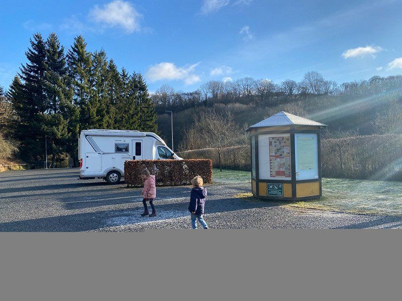
Wohnmobilhafen Nettersheim
We chose the parking space in Nettersheim as a place to stay. Here you can get the entire motorhome program including a barbecue area for €9. Although there are still traces of the flood disaster from last year, the parking space has been completely restored. For €9 you have everything you need. Thanks to the RV-friendly community
Urftstraße, 53947, Nettersheim, Deutschland
50° 29' 14" N 6° 37' 34" E
50.4872222 6.6261111
• Head toward Auf dem Hielig. Go for 76 m.
• Continue on Industriestraße. Go for 164 m.
• Continue on Südstraße. Go for 59 m.
• Turn left onto Bahnhofstraße (K59). Go for 257 m.
• Continue on K59. Go for 355 m.
• Turn right onto L205. Go for 3.7 km.
• Take the 2nd exit from roundabout onto L115 toward A1/Mechernich/Bad Münstereifel. Go for 516 m.
• Take the 3rd exit from roundabout onto L115 toward Köln/Trier/A1/Mechernich/Weyer. Go for 1.1 km.
• Take ramp onto A1 toward Köln. Go for 6.2 km.
• Take exit 112 toward Bad Münstereifel/Mechernich. Go for 359 m.
• Turn left onto B477 toward Mechernich. Go for 224 m.
• Pass 2 roundabouts and continue on B477. Go for 2.3 km.
• Take the 2nd exit from roundabout onto L61 toward Satzvey. Go for 2.0 km.
• Turn left onto Am Katzenstein toward Kommern/Kommern-Süd. Go for 524 m.
• Continue on Becherhofer Weg. Go for 300 m.
• Turn right. Go for 8 m.
• Turn left. Go for 28 m.
• Arrive at your destination on the right.
☍
18,2 km
( 16 min.)
Day
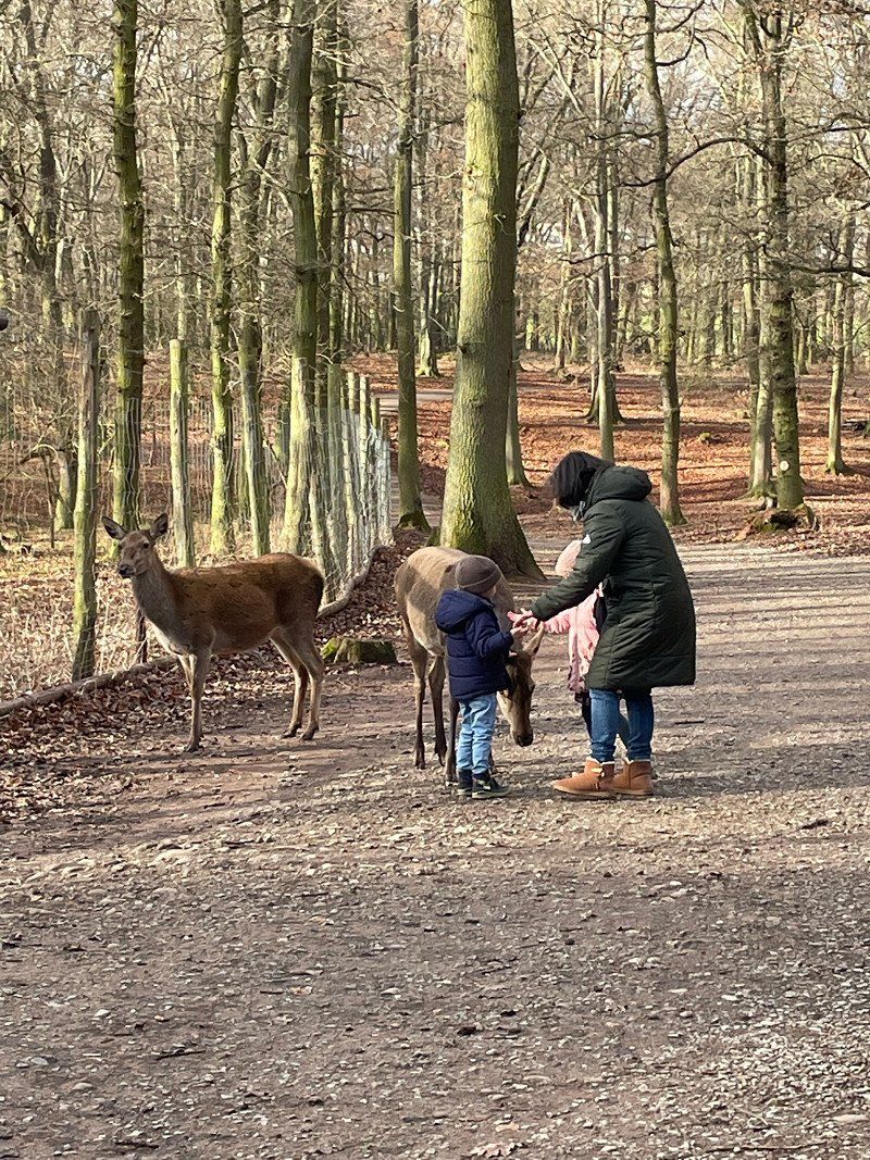
Parkplatz Wildpark, Mechernich, Deutschland
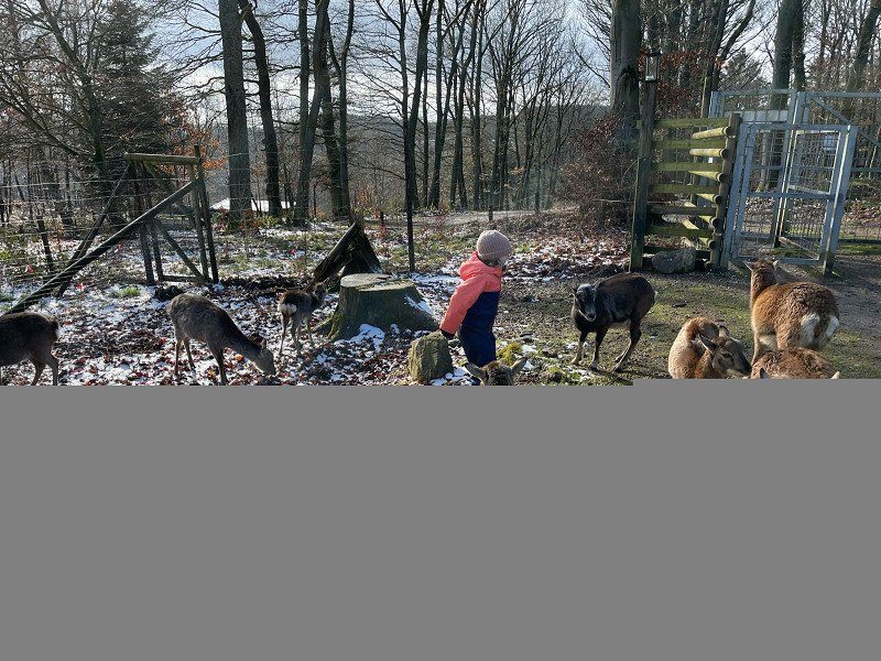
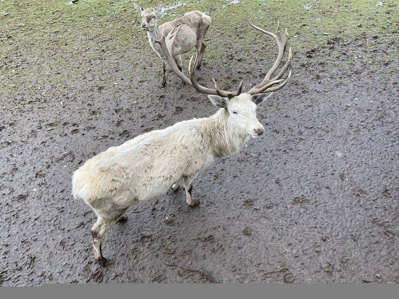
The park opens at 10 a.m. There you will find wild boars, deer, goats, deer, donkeys and many other animals in addition to a great children's playground. You can sometimes even enter the enclosure with a dog and pet the animals. I had never seen a deer up close before. let alone pet him. Great experience for young and old.
53894 Mechernich, Deutschland
50° 36' 19.8" N 6° 40' 45.3" E
50.6054890 6.6792409
• Head west. Go for 11 m.
• Turn slightly left toward Becherhofer Weg. Go for 9 m.
• Turn right onto Becherhofer Weg. Go for 1.2 km.
• Take the 2nd exit from roundabout. Go for 46 m.
• Continue on Becherhofer Weg. Go for 873 m.
• Take the 1st exit from roundabout onto Mechernicher Weg toward Zülpich/Euskirchen. Go for 965 m.
• Take the 2nd exit from roundabout onto Mechernicher Weg toward Zülpich. Go for 234 m.
• Turn left onto B266/B477 toward Schleiden/Gemünd/Kall/Mechernich. Go for 861 m.
• Turn right onto Eickser Straße (K20) toward Eicks. Go for 584 m.
• Turn left onto Eickser Straße. Go for 233 m.
• Continue on Neue Pfalz. Go for 334 m.
• Turn right onto Auf dem Kahlenbusch. Go for 380 m.
• Arrive at Auf dem Kahlenbusch.
☍
5,7 km
( 8 min.)
LVR-Freilichtmuseum Kommern, Eickser Straße, Mechernich, Deutschland
After a thorough discussion, we decided to skip the entrance fee. Animal park and open-air museum in one day with small children seemed too much for the kids. That's why we only took a siesta in the parking lot and enjoyed the view of the Cologne Bay.
Eickser Str., 53894 Mechernich, Deutschland
50° 36' 40.5" N 6° 37' 47" E
50.6112392 6.6297234
• Head north on Auf dem Kahlenbusch. Go for 380 m.
• Turn left onto Neue Pfalz. Go for 334 m.
• Continue on Eickser Straße. Go for 233 m.
• Turn right onto Eickser Straße (K20). Go for 584 m.
• Turn right onto B266/B477. Go for 2.1 km.
• Take the 1st exit from roundabout onto Mühlenthal. Go for 317 m.
• Arrive at Mühlenthal.
☍
3,9 km
( 4 min.)
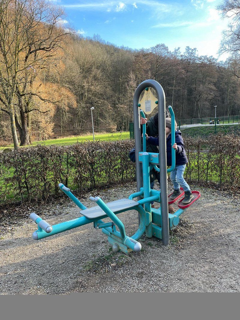
Kleintiermarkt Kommern, Mühlenpark, Mechernich, Deutschland
The Mühlenpark is on the main road just before Kommern. A large playground with a skate track, mini golf, trampoline, fitness and play equipment. Since the weather was still very good, we made a stopover here. Here we hoped to channel our grandchildren's energy into a tired-am-I-go-to-bed state. They had a lot of fun, but the condition didn't materialize.
Mühlenpark 1, 53894 Mechernich, Deutschland
50° 35' 42.2" N 6° 37' 31.9" E
50.5950420 6.6255369
• Head toward Zur Sommerrodelbahn on Mühlenthal. Go for 294 m.
• Take the 2nd exit from roundabout onto B477 toward Mechernich. Go for 1.0 km.
• Take the 2nd exit from roundabout onto Friedrich-Wilhelm-Straße (B477) toward Zülpich/Kommern/Euskirchen. Go for 606 m.
• Take the 1st exit from roundabout onto Friedrich-Wilhelm-Straße (B477). Go for 212 m.
• Pass 4 roundabouts and continue on Bruchgasse (B477). Go for 2.2 km.
• Take the 3rd exit from roundabout onto B477. Go for 1.6 km.
• Take the 1st exit from roundabout onto A1 toward Bad Münstereifel/Köln/Euskirchen. Go for 5.5 km.
• Take exit 113 toward B477. Go for 1.1 km.
• Turn left onto L115 toward B477/Zülpich/Mechernich/Eiserfey/Weyer. Go for 1.1 km.
• Take the 1st exit from roundabout onto L115 toward Trier/B477/Gemünd/Blankenheim/Nettersheim/Zingsheim. Go for 488 m.
• Take the 2nd exit from roundabout onto L205 toward Marmagen/Nettersheim. Go for 3.8 km.
• Turn left onto K59. Go for 355 m.
• Continue on Bahnhofstraße (K59). Go for 257 m.
• Turn right onto Südstraße. Go for 59 m.
• Continue on Industriestraße. Go for 240 m.
• Arrive at your destination on the right.
☍
18,7 km
( 17 min.)
Wohnmobilhafen Nettersheim
Since we liked it here so much, we also spent the second night here. This time there was a campfire with stick bread and grilled sausages.
Urftstraße, 53947, Nettersheim, Germany
50° 29' 14" N 6° 37' 34" E
50.4872222 6.6261111
• Head toward Auf dem Hielig. Go for 76 m.
• Continue on Industriestraße. Go for 164 m.
• Continue on Südstraße. Go for 59 m.
• Turn left onto Bahnhofstraße (K59). Go for 257 m.
• Continue on K59. Go for 355 m.
• Turn right onto L205. Go for 3.7 km.
• Take the 2nd exit from roundabout onto L115 toward A1/Mechernich/Bad Münstereifel. Go for 516 m.
• Take the 2nd exit from roundabout onto L206 toward Bad Münstereifel/Nöthen. Go for 6.4 km.
• Take the 2nd exit from roundabout onto Nöthen (L165) toward Bad Münstereifel. Go for 3.9 km.
• Turn right onto Trierer Straße (L165). Go for 323 m.
• Take the 3rd exit from roundabout onto L194 toward Köln/Euskirchen/Stadtmitte. Go for 1.7 km.
• Pass 2 roundabouts and continue on Euskirchener Straße (L194). Go for 4.3 km.
• Take the 1st exit from roundabout onto L11 toward Köln-Koblenz/Bonn/Flamersheim. Go for 4.8 km.
• Take the 1st exit from roundabout onto L210 toward Altenahr. Go for 4.3 km.
• Turn left onto L493. Go for 3.8 km.
• Turn right toward Münstereifeler Straße. Go for 402 m.
• Turn left onto Münstereifeler Straße. Go for 72 m.
• Turn right. Go for 49 m.
• Arrive at your destination on the right.
☍
35,2 km
( 32 min.)
Day
Monte Mare Rheinbach, Münstereifeler Straße, Rheinbach, Deutschland
Since the weather was extremely "modest" we went to Rheinbach to Monte Mare. We weren't the only ones with this idea. Nevertheless, the children had a lot of fun. If possible, you should start the bathroom during the week.
Münstereifeler Str. 69, 53359 Rheinbach, Deutschland
50° 37' 8.5" N 6° 56' 1.1" E
50.6190400 6.9336500
• Head south. Go for 49 m.
• Turn right onto Münstereifeler Straße. Go for 404 m.
• Take the 3rd exit from roundabout onto L493. Go for 4.2 km.
• Turn right onto Locher Straße (L210). Go for 4.3 km.
• Take the 3rd exit from roundabout onto Arloffer Straße (L11) toward Bad Münstereifel/Kirchheim. Go for 4.9 km.
• Take the 3rd exit from roundabout onto L194 toward Trier/B51/Bad Münstereifel. Go for 3.7 km.
• Take the 2nd exit from roundabout onto Kölner Straße (L194). Go for 628 m.
• Take the 3rd exit from roundabout onto L194 toward A1/Trier/Blankenheim. Go for 1.6 km.
• Take the 1st exit from roundabout onto Trierer Straße (L165) toward Nettersheim/Mechernich/A1. Go for 330 m.
• Turn left onto Große Bleiche (L165). Go for 3.9 km.
• Take the 2nd exit from roundabout onto Nöthen (L206) toward Zingsheim. Go for 6.4 km.
• Take the 2nd exit from roundabout onto L115 toward Trier/B477/Gemünd/Blankenheim/Nettersheim/Zingsheim. Go for 512 m.
• Take the 1st exit from roundabout onto L206 toward Gemünd/Kall. Go for 4.6 km.
• Turn left onto L22. Go for 1.3 km.
• Continue on Urfttalstraße (L204). Go for 1.1 km.
• Turn right onto L22. Go for 6.0 km.
• Take the 1st exit from roundabout onto B258. Go for 2.5 km.
• Take the 2nd exit from roundabout onto B258. Go for 1.3 km.
• Take the 3rd exit from roundabout onto K64 toward Hellenthal/Blumenthal/Eichen/Ingersberg. Go for 455 m.
• Continue on Eichen (K64). Go for 549 m.
• Continue on Ingersberg (K64). Go for 468 m.
• Continue on K64. Go for 568 m.
• Continue on Ingersberg (K64). Go for 389 m.
• Continue on K64. Go for 367 m.
• Continue on Müllershammer (K64). Go for 626 m.
• Turn left onto Schleidener Straße (B265) toward Aachen/Hellenthal. Go for 397 m.
• Pass 2 roundabouts and continue on Kölner Straße (B265). Go for 2.5 km.
• Take the 1st exit from roundabout onto Aachener Straße (L159) toward Aachen/Monschau. Go for 133 m.
• Turn left onto Oleftalstraße. Go for 801 m.
• Turn right. Go for 62 m.
• Arrive at your destination on the right.
☍
55,1 km
( 52 min.)
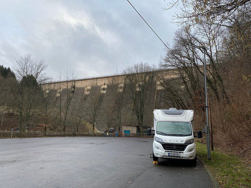
Wohnmobilstellplatz der Gemeinde Hellenthal, Oleftalstraße, Hellenthal, Deutschland
Since we wanted to go to the bird of prey sanctuary the next day, we chose the parking space at the bottom of the dam wall for the night. It is a normal parking lot with all the necessary facilities. The price for a family is disproportionately high at €19.50.
Oleftalstraße 30, 53940 Hellenthal, Deutschland
50° 29' 39" N 6° 25' 25.3" E
50.4941685 6.4236892
• Head toward Oleftalstraße. Go for 62 m.
• Turn left onto Oleftalstraße. Go for 801 m.
• Turn left onto Aachener Straße (L159). Go for 1.6 km.
• Turn left onto Wildfreigehege. Go for 275 m.
• Turn slightly left onto Wildfreigehege. Go for 209 m.
• Arrive at Wildfreigehege. Your destination is on the right.
☍
3,0 km
( 5 min.)
Day
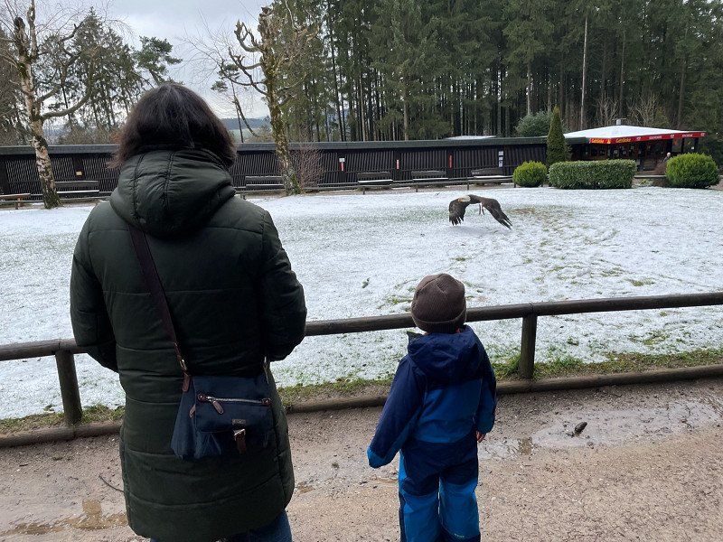
Greifvogelstation & Wildfreigehege Hellenthal, Wildfreigehege, Hellenthal, Deutschland
Absolutely recommendable for grandma, grandpa and grandchildren!
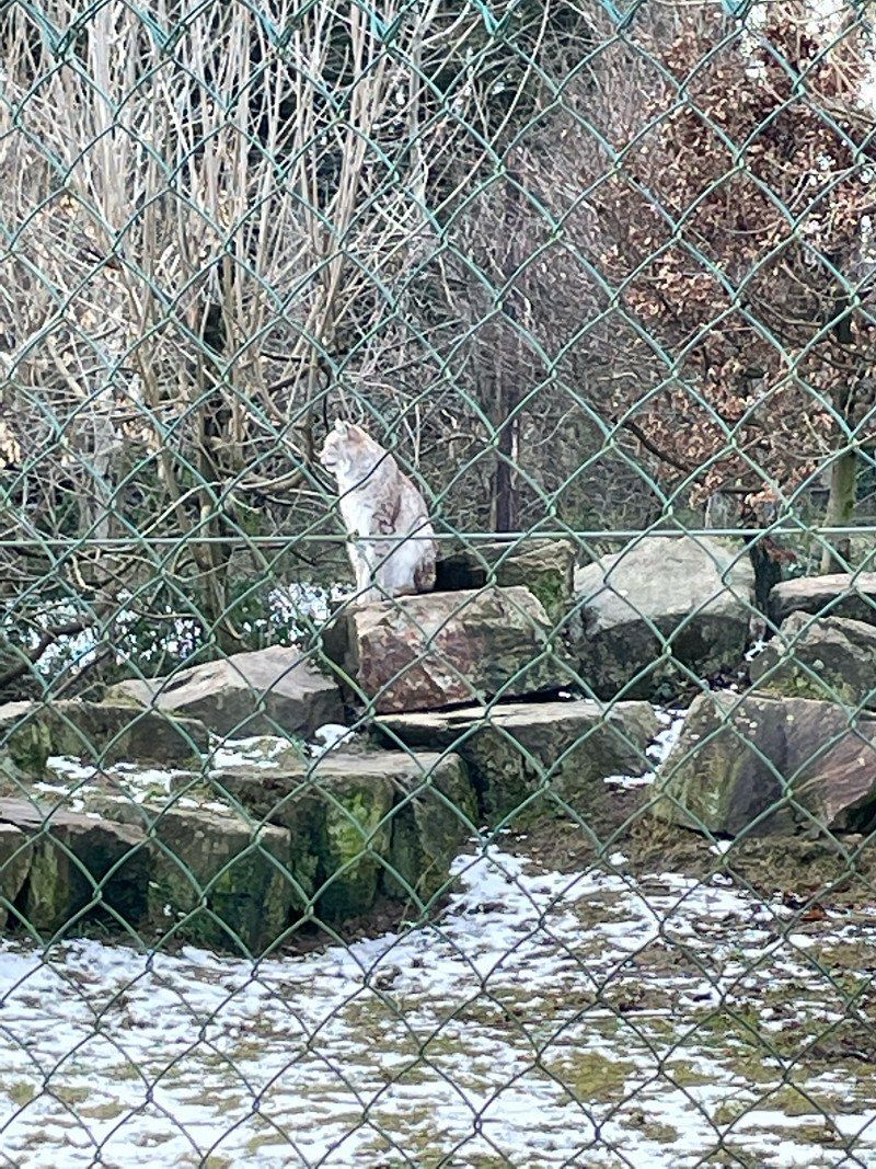
The birds of prey show is an absolute experience. For €5, the kiddies were even allowed to hold an eagle (with the physical support of Grandpa). Here, too, you can pet deer, stags, sheep, etc. There are also lynxes, arctic foxes, meerkats and much more.
Wildfreigehege 1, 53940 Hellenthal, Deutschland
50° 30' 9.2" N 6° 25' 47.2" E
50.5025648 6.4297916
• Head north on Wildfreigehege. Go for 484 m.
• Turn right onto Hellenthaler Straße (L159). Go for 1.8 km.
• Take the 2nd exit from roundabout onto Kölner Straße (B265) toward Köln/Schleiden. Go for 584 m.
• Pass 2 roundabouts and continue on Schleidener Straße (B265). Go for 2.4 km.
• Turn right onto Müllershammer (K64) toward Eichen/Ingersberg. Go for 626 m.
• Continue on K64. Go for 367 m.
• Continue on Ingersberg (K64). Go for 389 m.
• Continue on K64. Go for 568 m.
• Continue on Ingersberg (K64). Go for 468 m.
• Continue on Eichen (K64). Go for 549 m.
• Continue on K64. Go for 394 m.
• Take the 1st exit from roundabout onto B258 toward Trier/Blankenheim. Go for 1.3 km.
• Take the 2nd exit from roundabout onto B258. Go for 2.5 km.
• Take the 2nd exit from roundabout onto Am Kreuz (B258). Go for 3.9 km.
• Take the 2nd exit from roundabout onto B258 toward Trier/Koblenz/Blankenheim. Go for 4.1 km.
• Turn right onto Nürburgstraße (B258). Go for 260 m.
• Turn right and take ramp onto B51. Go for 6.8 km.
• Turn right onto L115 toward Ahrhütte/Rohr. Go for 10.4 km.
• Take the 3rd exit from roundabout onto Ahrtal (B258) toward Mayen/Nürburgring. Go for 21.7 km.
• Pass 2 roundabouts and continue on B258. Go for 454 m.
• Arrive at B258. Your destination is on the left.
☍
59,9 km
( 49 min.)
Alternative: Nürburgring Boulevard, Nürburg, Deutschland
Alternative excursion point
Tour of the Nürburgring and a visit to the racetrack museum
Nürburgring Boulevard 1, 53520 Nürburg, Deutschland
50° 20' 4.2" N 6° 56' 53.3" E
50.3344957 6.9481280
• Head northeast on B258. Go for 387 m.
• Take the 2nd exit from roundabout onto B258 toward A61/Koblenz/Mayen/Nordschleife. Go for 3.7 km.
• Turn left toward B258. Go for 46 m.
• Continue on B412. Go for 4.0 km.
• Turn left onto L10 toward Adenau/Hohe Acht. Go for 1.8 km.
• Turn left. Go for 379 m.
• Arrive at your destination.
☍
10,3 km
( 9 min.)
Alternative: Hohe Acht, Adenau, Deutschland
Alternative destination:
Tobogganing and snow hiking at the Hohe Acht ski area
Hohe Acht, 53518 Adenau, Deutschland
50° 23' 11" N 7° 0' 39" E
50.3863889 7.0108333
• Head northeast. Go for 379 m.
• Turn right onto L10. Go for 1.6 km.
• Turn right onto L10. Go for 112 m.
• Turn right onto B412. Go for 4.0 km.
• Turn right onto B258 toward Koblenz/Mayen. Go for 504 m.
• Turn left onto K1 toward Kelberg/Gewerbepark am Nürburgring. Go for 318 m.
• Continue on K93. Go for 1.2 km.
• Continue on Hauptstraße (K93). Go for 365 m.
• Continue on K92. Go for 2.9 km.
• Continue on Dreeser Straße (K92). Go for 161 m.
• Turn left onto Hauptstraße (L94). Go for 205 m.
• Turn right onto Dauner Straße (K89). Go for 93 m.
• Continue on K89. Go for 670 m.
• Continue on Hauptstraße (K89). Go for 798 m.
• Continue on K89. Go for 2.0 km.
• Continue on Zum Ring (K89). Go for 158 m.
• Turn right onto Kelberger Straße (B410). Go for 1.8 km.
• Pass 2 roundabouts and continue on Dauner Straße (B410). Go for 2.1 km.
• Turn left onto L46 toward Bitburg/Daun. Go for 6.5 km.
• Pass 2 roundabouts and continue on L46. Go for 4.5 km.
• Take the 1st exit from roundabout onto B257 toward Bitburg/Aachen/B421/Gerolstein/B410/Zentrum. Go for 937 m.
• Pass 2 roundabouts and continue on Bitburger Straße (B257). Go for 31.6 km.
• Take ramp onto A60 toward Lüttich/Liège/Luxembourg/Bitburg. Go for 6.5 km.
• Take exit 6 toward Luxembourg/Bitburg onto B51. Go for 10.4 km.
• Take ramp onto B257 toward Luxemburg/Echternach/Irrel. Go for 16.5 km.
• Take ramp onto K20 toward Ferschweiler/Ernzen/Irrel. Go for 2.7 km.
• Continue on Ferschweilerstraße (K20). Go for 734 m.
• Turn right onto Ferschweilerstraße. Go for 339 m.
• Arrive at Ferschweilerstraße. Your destination is on the left.
☍
99,9 km
(1 hrs. 18 min.)
Alternative: Dinosaurierpark Teufelsschlucht, Ferschweilerstraße, Ernzen, Deutschland
Open from March 12th, 2022 Time travel through the history of the earth
Ferschweilerstraße 50, 54668 Ernzen, Deutschland
49° 50' 42" N 6° 26' 5.6" E
49.8449987 6.4348956
• Head northwest on Ferschweilerstraße. Go for 339 m.
• Turn left onto Ferschweilerstraße (K20). Go for 734 m.
• Continue on K20. Go for 2.5 km.
• Take the 1st exit from roundabout onto B257 toward Bitburg/Wolsfeld. Go for 16.3 km.
• Turn left onto B257 toward Lüttich/A60/Wittlich/Köln/Aachen/Prüm/Bitburg-Zentrum. Go for 207 m.
• Turn right toward Lüttich/A60/Wittlich/Köln/Aachen/Prüm/Bitburg-Zentrum. Go for 182 m.
• Take ramp onto B51. Go for 9.7 km.
• Take ramp onto A60 toward Wittlich. Go for 28.5 km.
• Take exit 11 toward Koblenz/Wittlich-Mitte onto A1. Go for 31.3 km.
• Take exit 120 toward Koblenz/Köln onto A48. Go for 38.6 km.
• Take exit 7 toward Polch/Mendig/Welling/Trimbs. Go for 409 m.
• Continue on L113 toward Mendig/Welling/Trimbs. Go for 3.1 km.
• Take the 2nd exit from roundabout onto Thürer Weg (L113) toward Mendig/Thür. Go for 1.3 km.
• Continue on L113. Go for 1.7 km.
• Turn right onto Bundesstraße (B256) toward Neuwied/Andernach/Kruft/Mendig. Go for 1.6 km.
• Turn left onto L113 toward Maria Laach/Mendig/Gewerbegebiet Bahnstraße. Go for 1.5 km.
• Turn right onto Heidenstockstraße (L113). Go for 300 m.
• Turn right onto Brauerstraße. Go for 345 m.
• Arrive at Brauerstraße. Your destination is on the left.
☍
138,7 km
(1 hrs. 25 min.)
Alternative: Lavakeller (Mendig), Brauerstraße, Mendig, Deutschland
Many steps lead down below the town of Mendig: Here in the lava cellars, which were hammered into the cooled volcanic rock, it is consistently cold even in the hottest summers, there is a mysterious dim light, it smells of a touch of moisture.
Brauerstraße 5, 56743 Mendig, Deutschland
50° 22' 40.5" N 7° 17' 4.9" E
50.3779122 7.2846939
• Head southwest on Brauerstraße. Go for 345 m.
• Turn right onto Laacher-See-Straße (L113). Go for 1.3 km.
• Keep left onto Laacher-See-Straße (L113) toward A48/Trier/Mayen. Go for 39 m.
• Turn left onto B262 toward A48/Trier/Mayen. Go for 558 m.
• Keep left onto B262. Go for 3.2 km.
• Take ramp toward Thür/Kottenheim/Gewerbegebiet Mendig-Flugplatz. Go for 319 m.
• Turn right onto K93 toward Mayen/Kottenheim/Gewerbegebiet Kottenheim/Mayen. Go for 486 m.
• Pass 2 roundabouts and continue on K93. Go for 1.6 km.
• Turn left onto Rudolf-Diesel-Straße. Go for 216 m.
• Continue on Nikolaus-Otto-Straße. Go for 596 m.
• Arrive at Nikolaus-Otto-Straße. Your destination is on the left.
☍
8,6 km
( 10 min.)
Alternative: Tolli-Park, Nikolaus-Otto-Straße, Mayen, Deutschland
Adventures in Tolli Park! Water fun, petting zoo, children's circus, indoor park... and much more. great family fun in the amusement park in Mayen
Nikolaus-Otto-Straße 11, 56727 Mayen, Deutschland
50° 20' 2.5" N 7° 15' 54" E
50.3340292 7.2650083
• Head west on Nikolaus-Otto-Straße. Go for 596 m.
• Continue on Rudolf-Diesel-Straße. Go for 217 m.
• Turn right onto K93. Go for 1.2 km.
• Pass 2 roundabouts and continue on K93. Go for 940 m.
• Turn right toward Köln/A61/Mendig. Go for 33 m.
• Take ramp onto B262. Go for 4.6 km.
• Take ramp onto A61 toward Köln/Bonn. Go for 32.7 km.
• Take exit 29 toward Flughafen Bonn/Meckenheim onto A565. Go for 19.9 km.
• Take exit 4 toward Köln onto A555. Go for 20.1 km.
• Keep right onto Militärringstraße (B9/B51) toward Zentrum. Go for 5.7 km.
• Turn left toward Deutzer Brücke/Altstadt/Heumarkt/Kunsthochschule für Medien Köln. Go for 33 m.
• Turn slightly left onto Filzengraben toward Deutzer Brücke/Altstadt/Heumarkt/Kunsthochschule für Medien Köln. Go for 259 m.
• Turn right onto An der Malzmühle. Go for 72 m.
• Continue on Am Malzbüchel. Go for 70 m.
• Turn right onto Heumarkt toward Flughafen/Altstadt. Go for 152 m.
• Turn left toward Augustinerstraße/L111. Go for 329 m.
• Turn right onto Augustinerstraße (L111). Go for 45 m.
• Turn right onto Heumarkt toward Altstadt. Go for 174 m.
• Continue on Unter Käster. Go for 10 m.
• Arrive at Unter Käster.
☍
87,1 km
(1 hrs. 2 min.)
Köln, Deutschland
50° 56' 15.1" N 6° 57' 37" E
50.9375310 6.9602786
• Head toward Seidmacherinnengäßchen on Unter Käster. Go for 10 m.
• Continue on Heumarkt. Go for 174 m.
• Turn right onto Augustinerstraße (L111). Go for 475 m.
• Make a U-Turn onto Cäcilienstraße (L111). Go for 528 m.
• Keep left onto Pipinstraße (L111) toward Stadthaus/LANXESS Arena/Deutzer Brücke/Koelnmesse. Go for 756 m.
• Keep left toward Flughafen. Go for 74 m.
• Turn slightly left onto Mindener Straße (L111). Go for 780 m.
• Turn left onto Deutz-Mülheimer Straße (L188) toward A4/A3/Mülheim/Koelnmesse/Messehochhaus. Go for 722 m.
• Take ramp onto Zoobrücke (B55A) toward Flughafen Ost/A4/A3. Go for 3.3 km.
• Continue on A4 toward Oberhausen/Frankfurt a.M./Flughafen Bonn. Go for 21 m.
• Take the exit toward Oberhausen onto A3. Go for 47.5 km.
• Take exit 16 toward Essen onto A52. Go for 12.4 km.
• Take exit 28 toward Essen-Rüttenscheid/B224 onto L176 (Anschlussstelle Essen-Rüttenscheid). Go for 547 m.
• Keep left onto Norbertstraße toward Messe/Gruga. Go for 1.2 km.
• Turn left onto Alfredstraße (B224). Go for 1.6 km.
• Continue on Bismarckstraße (K15). Go for 1.1 km.
• Turn right onto Am Waldthausenpark toward Zentrum. Go for 96 m.
• Turn slightly left onto Am Waldthausenpark. Go for 22 m.
• Turn right onto Alfred-Herrhausen-Brücke. Go for 21 m.
• Continue on Am Waldthausenpark. Go for 138 m.
• Turn right onto II. Hagen. Go for 31 m.
• Turn left onto Theaterplatz. Go for 55 m.
• Turn left onto I. Hagen. Go for 80 m.
• Arrive at I. Hagen.
☍
71,6 km
( 54 min.)
Essen, Deutschland
51° 27' 20.3" N 7° 0' 41.6" E
51.4556432 7.0115552