
Challenging hikes in the beautiful mountains of Norway during the day and a delicious meal in good company in the evening: If you don't want to hike from hut to hut on your own in Jotunheimen and Valdres, the Fjellhotel Grønolen Fjellgard will not only find experienced and entertaining hiking guides, but also one true gourmet cuisine for hikers and a campsite nearby. We tested four very different hikes in Valdres and Jotunheimen with the Grønolen brothers and after a week were not only completely flat, but also completely thrilled.

Norway hiking tip 1: hiking tour on the Mugnetind in Valdres to warm up
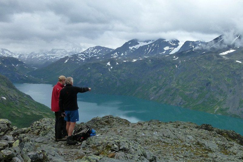
Uphill we go - sometimes gentle, sometimes really steep and sometimes it's even easy climbing. In between, there are short passages in which it gets a little more flat and the legs can relax a little. But the summit of Mugnetind is still damn far away and after every climb there is a slight hope that it has come a little closer.
Until he suddenly sits at 1738 m directly above you. A final steep climb and after about 2.5 hours it's finally done - with an almost majestic view of the Gjendealpen and over large parts of the Valdres region as a reward.
Now the hardest part of the tour on the Mugnetind has been completed - so it seems. A tour that by the way is indicated as moderate, and which is also suitable for children. In theory, now the easier part of the descent follows and in your mind you can imagine yourself back in the motorhome within two hours to put your feet up.
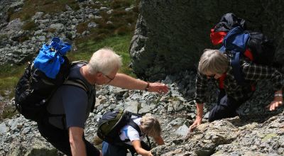
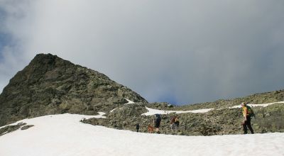
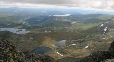

Photo: Claudia Rothkamp
But this actually remains a bit of a dream, because mountain guide Øyvind is no friend of well-trodden paths. In his opinion, nobody needs a guide for that. So instead he leads the way down across scree fields and around the mountain. While jumping from stone to stone is kind of fun in the beginning, most hikers get tired of this rather quickly.
The constant concentration on the next step in combination with the legs that have already been somewhat stressed by the ascent is exhausting. More and more people are looking down to see if there is an end in sight. And after about three hours descent past lakes, snow fields and mountain sheep, we finally made it.
Satisfied and tired, we now return to the starting point at the small Hotel Grønolen Fjellgard , which nestles comfortably against a mountain slope below Beitostølen. Time for a little muscle relaxation in the sauna and whirlpool before heading out to eat and back in the motorhome.

Summit happiness, guide and culinary delights in one package
Actually, the relaxation part is only for the guests today. Because for hiking guide Øyvind the real part of his working day begins. After all, the trained gourmet chef, who runs the hotel and the associated holiday homes together with his brother Tor Erik, is also responsible for the culinary well-being of the guests. A task that Øyvind loves and lives. And you can tell that from the food. Wherever possible, he tries to incorporate local ingredients into his dishes - starting with fish, reindeer meat, veal, goat, pork and sheep. This list goes on with potatoes, root vegetables and sophisticated sauces, which are partly based on fresh herbs and partly on rose petals collected by hand. At the same time Øyvind is convinced: “In terms of taste, it can be gourmet, but the portions I use are more like good old-fashioned home cooking. After all, those who have been on the mountain all day are really hungry - and you also have to build up strength for the next hike. ”

Norway Hiking tip 2: Hike in the Jotunheimen National Park to the Knutshøe
And that is not long in coming. After a much too short night in the motorhome, the next hike awaits. Early the next morning Tor Erik enters the breakfast room and advises to fill the thermos with a lot of hot coffee or tea: "It will be wet and cold today." A little voice in the back of the head can't help noticing that this is actually the perfect weather to spend the day in bed with a good book and relax your muscles - which some other hikers apparently thought as well. Only two Dutchmen are not deterred by the weather either and are ready for the tour to the 1517 m high Knutshøe in eastern Jotunheimen.
An approximately moderately difficult tour, with almost 500 meters of altitude difference and a total of 13 kilometers to be mastered. It has been on the personal hiking wish list for a long time, as it is at least as beautiful as the tour on the Besseggen, but is far less crowded. In Norwegian hiking literature it is described as easily accessible, but it has its pitfalls. A good argument to think about accompanying a guide.

Photo: Claudia Rothkamp
Do you have enough experience for Knutshøe?
It is not for nothing that a sign at the beginning of the route asks "Do you have enough experience for Knutshøe?" and warns against taking shortcuts in the steep terrain. There is also no path marking. But luckily we have Tor Erik with us as a guide - even if he sometimes shows "paths" that you would never have recognized as such. Shortly after the start of the tour at Vargebakkan, one of the steepest and most exposed parts of the hike is waiting. But Tor Erik ensures us: "If you master this piece, you won't have any problems with the rest of the route, at least not in your head." Those who like to climb will have fun here, even if the wet rock does not exactly increase the safety of grip and occur.
Nevertheless, the easy climbing sections can be mastered without physical difficulties, the real challenge might be rather the head for some people. The route over the approximately five kilometers long mountain ridge with its secondary peaks takes about two hours until the main summit is finally reached. For well-trained people like Tor Erik, this is of course faster. However, ordinary hikers like us have to catch a breath every now and then in order to cope with the ascent.
And let's not forget that it is also important to enjoy the great panorama every now and then: on the right, even in bad weather, there is a fantastic view of Lake Gjende and the ridges of the Besseggen. To the left, the eye is drawn to the green Leirungen valley.
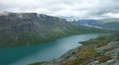
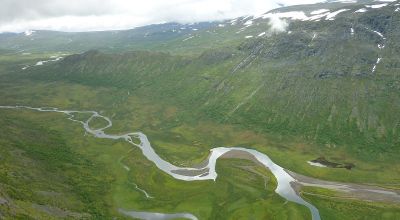
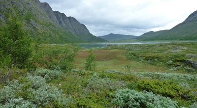

Photo: Claudia Rothkamp
Missing signage on Knutshøe: caution is a must
The route continues for about a kilometer on the ridge of Knutshøe until it slowly leads down into the valley. Due to the lack of signage, some people catch the notorious "Blindveien" - the "blind way" - for the descent, which is extremely steep and dangerous. A clear signage would remedy this, which has not least been demanded by the tourist association, the Red Cross and various mountain rescuers for several years. However, the environmental protection agency is vehemently against it as they do not want to intensify mountain tourism.
The discussion culminated some years ago in an incomprehensible action: After the fatal crash of a young woman, her angry father independently marked the path with red colored dots, which were then painted gray again by the Environmental Protection Agency. The argument: the red color would disturb nature too much. The result is an incomprehensible shake of the head of most hikers - and a search for gray spots on gray rock, where the red still shimmers through a little. But if you have found the right way down into the valley, you will be rewarded with a relaxed walk back through a wonderful green valley. The narrow trail would probably not even qualify as such in Central Europe, but it is pure nature. There is also a beautiful beach on the shores of the Øvre Leirungen, where you can bathe your feet in the cool glacier water.

Norway hiking tip 3: Easy tour over the Synshorn to the summer pasture
The next day there is more of an easy tour scheduled - quite relaxing, at least that's what Tor Erik and Øyvind think. At the sight of the 1464 m high Synshorn in Valdres, however, first doubts arise. "Now we go up there, then over the ridges of Heimre Fagerdalshøe and on the other side back down into the valley and to our summer pasture," explains Øyvind, who alternates daily with Tor Erik as mountain guide. Admittedly, there is only 400 meters of altitude to be overcome on this tour, but the legs that were tired from the previous day had really imagined something different under relaxation.
Nevertheless, the ascent is worthwhile, because the panorama on the Synshorn compensates for many hardships: In the west, the lake Bygdin extends, on which the venerable old lady M / S Bitihorn circles. In the distance you can see the peaks of Falketind and Uranostind and in the south you can see the Bitihorn and the mountains of Valdres. In the east you can see the summer alpine huts at the shore of Lake Vinstervatn, very small down in the valley. Those are the end destination of the approximately 4-hour hike.

First of all, however, we continue northwards over the ridges of Fagerdalshøe, where fascinating panorama images always open up. Then follows the sometimes quite steep descent - a cross-country tour that is not listed in any hiking guide. Those who do not know their way around here might have a hard time finding the right way. Øyvind however seems to know it like the back of his hand. No wonder. As children, he and Tor Erik spent two months every summer at Grønolstølen family pasture - without electricity and running water, but with the mountains right outside.
Today the mountain pasture, which has been family-owned since the 18th century, is no longer traditionally managed, but it is an integral part of the hiking program of the Grønolen brothers. Just like the mighty Rømmegrøt - the Norwegian national dish, which is served with cinnamon and sugar and sometimes with raisins. Delicious! For those who are looking for an additional challenge, the two Grønolen brothers also have a slightly different tour of the Synshorn in their program: the climbing path Via Ferrata.

Photo: Grønolen Fjellgard
Norway hiking tip 4: The Besseggen classic with a difference
The crowning highlight of the hiking week with the Grønolen brothers is the Besseggen - one of the most famous and sought-after tours in Jotunheimen, which is often very crowded in summer. To avoid the main stream of hikers, Tor Erik therefore chooses the little-used Jo-Stigen for the ascent. It follows the historical hunter path, which was used by the notorious reindeer hunter Jo Gjende in Norway. After about an hour's ascent from Gjendesheim along the banks of Lake Gjende, the narrow path winds steeply up the mountain.
Tor Erik chooses this route not only because there are hardly any other hikers, but above all because it is much more fun. Tor Erik thinks. Because the Jo-Stigen is a real challenge. For about two hours it is really steep uphill - first over stone fields and scree and then increasingly with easy climbing passages, in which the hands become almost as important as where you set your feet. Sometimes even the rope has to be used for protection. It's no wonder that Tor Erik shoulders several backpacks at some point to make the ascent a little easier for the hikers in his group. Some of you may be wondering why you are doing this strain.

You'll get your answer to this question as soon as the Jo-Stigen finally is overcome. Because one of the most beautiful views that the fjell in Norway has to offer is waiting for you: the fantastic panorama with the Bessvatnet on one side of the ridge and the Gjende on the other. Even the rather bad weather doesn't matter anymore. Here you build up new motivation for the last and steepest climb of the Besseggen and then it is finally done. So you believe.
Because about halfway downhill there awaits another part where you really need to concentrate when climbing down with help of an iron chain. This "abbreviated" Besseggentour via the Jo-Stigen took a good six hours. On the other hand, this fantastic Norway hike will remain in your memory for a lifetime. And of course, there will be a festive meal prepared by Øyvind in the evening as a reward.

Photo: Claudia Rothkamp
Guided hikes in Valdres and Jotunheimen: data and facts
Grønolen Fjellgard offers various guided hikes every summer, which can be booked individually or as a package including full board. The focus is on tours that many hikers would not dare to do without an expert guide. The level of difficulty ranges from moderately difficult to slightly demanding. For really well-trained hikers, there are also demanding 2-day tours on certain dates, with four or seven peaks on the program. The hikes on offer vary from year to year.
If you get in touch early, you can also book tours according to individual wishes, depending on the date. Grønolen Fjellgard is located near Beitostølen and is about 225 km from Oslo via the E 16. The family mountain hotel offers a total of 110 beds, which are spread over 22 family, single and double rooms with shower and toilet in the hotel as well as twelve holiday homes and apartments. The closest campsite Beitostølen Camping is about five kilometers away. If you are self-sufficient with the motorhome in Norway and book a hiking package with the Grønolen brothers, you can also inquire individually in advance from Tor Erik and Øyvind whether there is a nice corner somewhere on the Grønolen property as a parking space for the Camper there. And, of course, you can reserve a table in the hotel's restaurant regardless of a hiking package and let yourself be spoiled with culinary delights.